mits10.aori.u-tokyo.ac.jpmits10.aori.u-tokyo.ac.jp/asiacore/workshop 2011関連... · translate...
TRANSCRIPT

Ac#vity Reports and Research Proposals from Group 1 (Physical Oceanography)
Akihiko Morimoto Nagoya University

Ac#vity of G1 in 2011
• The assessment of the coastal environment dynamics in the offshore and onshore area in Indonesia based on Sato-Umi concept
• Habitat mapping in Malaysia
• CTD and Mooring observa#ons in Thailand
• Dataset in Upper Gulf of Thailand • Numerical study around coastal area in Vietnam


1. Emecs 9 Symposium, Bal#more, Oct. 2011
2. Paper in prepara#on : Sea Surface Temperature Variability Within Indonesian Water Revealed by Satellite Data A sustainable model of integrated mul# tropic aquaculture for the brackish water in the northern coastal area of Karawang West Java, Indonesia.
Idris Mandang : A numerical study of lateral dynamics and associated transport of fine sediment in the Mahakam Estuary. Proceeding of Interna#onal Seminar on Water Related Risk Management. Indonesian of Hydraulics Engineer.
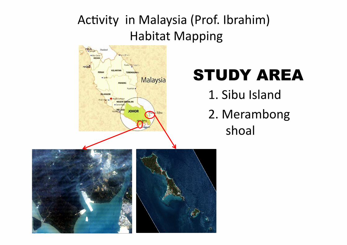
STUDY AREA 1. Sibu Island 2. Merambong
shoal
Ac#vity in Malaysia (Prof. Ibrahim) Habitat Mapping

Sea Truth Data (28 September 2011) – Sibu Island

Overlay of sea truth data
Sea truth legend:

27-‐31 October 2011 21-‐25 November 2011
Ac#vity in Thailand (Dr. Pramot)
Low salinity water distribu#on in the Upper Gulf of Thailand during and a[er flooding

27-‐31 October 2011 21-‐25 November 2011
Sea surface salinity

CTD and Mooring observa#on in Banpakong estuary
(Drs. Anukul, Morimoto, Kaneda) • Aquacultures of shellfish have been carried out in the Banpakong estuary, which is one of the main fishery industries around Chonburi, Thailand. In this area oyster and green mussel are mainly cul#vated.
• Mass mortality of the shellfish takes place every year from the end of September to early October. Total financial damage in 2010 was several million Baht.
• The aim of the present study is to elucidate cause of the shellfish mortality in the Banpakong estuary.

CTD observa#on in 2011
• Temperature
• Salinity • Dissolved Oxygen • Turbidity • Chlorophyll a • Nutrients
We conducted 3 #mes CTD observa#on and water sampling ・September 4-‐5 ・October 4-‐5 ・October 24-‐25

Mooring Observa#on in Banpakong estuary
Mooring Instruments ・ Current Meter (Compact-‐EM) ・ Temperature and salinity Meter with wiper (Compact-‐CTW) ・ DO Meter with wiper (Compact-‐DOW) ・ Temperature Meter (Hobo)

Time series of Dissolved Oxygen (blue line) and Salinity (red line)

Special field observa#ons in the Upper Gulf of Thailand
Transparency CTD, DO Water sampling (Nut, Chl.a) Plankton net Light characteris#cs ADCP GPS buoys tracking
Data set of UGOT observa#ons 2003-‐2009 Yutaka MICHIDA (U. Tokyo, Japan) Toru SUZUKI (MIRC, Japan)

Objec#ves
1. To develop the air-‐correc#on algorithm of ocean color images 2. To develop the water-‐correc#on algorithm of ocean color images 3. To develop the hydrodynamical model 4. To develop the ecosystem model 5. To inves#gate the rela#on between surface convergence and primary produc#on
What is the genera#on mechanism of the patchiness structure in the ocean?

Cruise # Date Vessel Port Chief Sci. Remarks
UGOT01 2003/10/9-‐10 Kasetsart I Ko Loi Matsumura
UGOT02 2003/12/4-‐6 Kasetsart I Ko Loi Matsumura
UGOT03 2004/1/13-‐15 Kasetsart I Ko Loi Matsumura
UGOT04 2004/5/12-‐15 Kasetsart I Ko Loi Sojisuporn
UGOT05 2004/10/7-‐9 Kasetsart I Ko Loi Sojisuporn
UGOT06 2005/2/5-‐6 Fishing boat Ansila Michida
UGOT07 2005/5/17-‐18 Chulavijai Sichang Sojisuporn
UGOT08 2005/7/26-‐29 Kasetsart I Fishing boat
Ko Loi Sojisuporn Michida
UGOT09 2005/11/22-‐25 Kasetsart I Ko Loi Sojisuporn
UGOT10 2006/7/23-‐26 Kasetsart I Ko Loi Sojisuporn
UGOT11 2009/3/20-‐21 Kasetsart I Ko Loi Yanagi Turbomap
UGOT12 2009/8/24-‐25 Kasetsart I Ko Loi Yanagi Turbomap

Bach Long Vy
Con Co
Ac#vity in Vietnam (Mr. Tu) Circula#on around islands in Gulf of Tonking


Implementa#on Plan 2012-‐2015 • Indonesia
Shore line changes around Karawang, west Java using satellite data
• Malaysia Habitat mapping and es#ma#on of seagrass and seaweed biomass based on both in-‐situ and remote sensing
• Thailand Habitat mapping River water movement in the Upper Gulf of Thailand Mass mortality of shellfish in Banpakong estuary
• Vietnam Development of numerical models around Bach Long Vy and Con Co. Satellite data analysis in Gulf of Tonking
• Exchange members in FY2012 Samsudin Ahmad (Malaysia) to analyze satellite data for habitat mapping A student in Burapha University (Thailand) to analyze mooring data in Banpakong estuary
• Integrative inter-disciplinary research site Tinggi Island or (Sibu Island, Merambong Shoal) in Malaysia