ميِحرّلا ِنَٰمحرّلا ِهلّلا ِمْسِب work.pdfthe high folded zone. the...
TRANSCRIPT


بسم الله الرحمن الرحيم
هى الذ خلق السوىات واالرض ف ستة أام
ثن أستىي عل العزش علن ها لج ف األرض وها خزج هنها وها نزل هي السوآء وها عزج
نوا كنتن واهلل بوا تعولىى ف ها وهى هعكن أ بصز
٤سىرة الحدد آة

Abstract
The field work for this academic year (2008-2009) was operated in
Shaqlawa District in Northeastern part of Erbil City. This work includes
the construct of geologic map, geologic cross-section, and columnar
section; these studies were done according to the lithology descriptions
and measuring the thickness, dip angle of the bed, slop angle and slop
distance and recording the notice about the sedimentary structures.
In this work the formations Kolosh, Khormala, Gercus, Pila Spi
and Avana were studied.
The area of the study (Shaqlawa) according to the tectonic divisions of
Iraq is located within High Folded Zone.
The stratigraphy in the studied area includes five formations these are “as
mentioned above” Kolosh consist mainly of shale's and sandstones;
Khormala consist mainly of dolomite and recrystallized limestones;
Gercus consist mainly of red and purple shales, mudstones, sandy and
gritty marls; Pila Spi consist mainly of Limestone, yellowish dolomitic
limestone; and Avana consist mainly of limestones.
At first Praise to Allah in order to achieve this
research.
Special thanks for Mr. Waleed Sinjari for supervising the project
and continuing guidance & Mr.Soran for their assistance of our
team.
Our thanks for dean of college of science, Head and
academic staff of Geology Department.
Extend thanks to all of Dr. Ahmed Aqrawi and Dr.
Mariwan A.Hama Saeed supervisors of field course.
We would like to extend my thankfulness also to Dr.
Mazin Y. Tamar–Agha and Dr.Abdullah A.Omer for gave us the
information abut the field work and writing reports. …..
We are also thanking my fellow students, for helping us in
providing references and previous research on the region during
writing this report.
Finally, we express from our hearts and soul thanks to
our family members, friends near and far, for their patience,
faith and just being around during this time of our life.
{Thanks everybody}
Students October 2009
List of Contents
Chapter One ---Introduction Page No.
1.1 Preface......……………………………….…….. 1
1.2 Geographic Location …………………………...1
1.3 Aim of the study ………………………………..3 1.4 Methodology ……………….………...……….5
Chapter Two--- Geology of studied area
2.1 Preface………………………………………….6
2.2 Tectonic Setting ………………………………..6
2.3 Structure………………………………………...8
2.4 Geomorphology …...……….………………….11
Chapter Three--- Stratigraphy
3.1 Preface………………………………………..13
3.2 Kolosh Formation…………………………….13 3.3 Khurmala Formation………………………….14
3.4 Gercus Formation…………………………….15
3.5 Pila spi Formation……...……………………..16 3.6 Avana Formation …….………………………17
Chapter Four---- Conclusion and Recommendations
4.1 Conclusion……………………………………20
4.2 Recommendation …………………………….22
References…………………………………………………..23
Appendix …………………………………...………………24
CHAPTER ONE
INTRODUCTION
1.1 Preface
Shaqlawa area geographically, located in the eastern part of Iraqi
Kurdistan Region. It is located at the limb of asymmetrical Safin anticline
within high folded zone. The exposed Formations in the study area are
extending from the Upper Cretaceous to Tertiary period.
1.2 Location Area
The study area (Shaqlawa) is located at the northeastern part of
Erbil City in Iraqi Kurdistan Region, it is about 55 Km. from Erbil city at
(36 17 56– 36 26 34" N) and (44 28' 24"- 44 37' 06" E). The location
was chosen for the study is showed in Fig. (1-1).
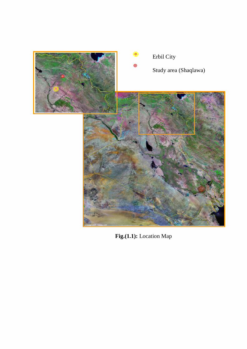
Erbil City
Study area (Shaqlawa)
Fig.(1.1): Location Map
1.3Aim of the study
Field geology offers students the opportunity to apply what has
been learned in the classroom to real geological problems. Unless you
already have fairly extensive field experience you should emerge from
the course with a much deeper and more realistic appreciation of
problems attending the collection, analysis, interpretation, and synthesis
of geological information. In the field, rocks look different than they do
in textbooks or on lab benches. A valuable aspect of the field course is
practice in approaching an outcrop and knowing what to do next. Even an
incorrect solution to a field problem or a faulty interpretation of a
geological event is of value because it prepares the way for a better
solution or interpretation next time. As you get better at your job through
practice, you gain confidence in your abilities. For this reason, a field
course must stress individual effort and personal initiative. Students
usually work in teams, primarily for safety, and we all realize that a good
deal of learning can be derived from discussing ideas with classmates.
But it is your own interpretation of the geology, developed from your
own investigation that will be of most value. Beside the field application
construction of curriculum course with in the geological department, that
the aims following:
1- Teaching students for using the geological field instruments practically
that are used in research and geological studies.
2- Showing students the geological feature in close distance especially
concerning the geological structure and different geological Formations
and the reconstruction and studying the lithologicl formations in detail in
the field.
3- Doing the complete geological survey throw preparing the geologic
map for the part of satin folds and also teaching students who to draw a
complete geological map.
4- Drawing the geological cross-section for the field by using the
instruments this paragraph requires a detail study a bout the litho logy and
the attitude of geological formation structure with the geological cross-
section pass throw it.
5- The summer field work is considered as a train for students to for how
to work correctively in all fields and also it is like the examination in
standing and potion that is needed to make such a kind of
geomorphologic feature and also contains the different variety on river
pattern.
1.4 Methodology
1.4.1 Field work
This work includes the construct of geologic map, geologic cross
section, and columnar section, this depend on the describing the lithology
and measuring the thickness, dip angle of the bed, slop angle and slop
distance and recording the notice about the sedimentary structures.
The tools which should be used in the field to draw cross-section like:
1- Geological compass.
2- Abney level.
3- Rod.
4- Foot meter.
5- Geologic hummer.
6- Pocket lens.
7- HCL.
8- Digital Camera
1.4.2 Office work
This work include:-
1. Drawing of geologic' cross section
2. Drawing of geologic columnar section of included Formations.
CAPTER TWO
GEOLOGY
2.1Preface
Shaqlawa located at high folded zone at unstable shelf according to
the tectonic divisions of Iraq. The fold of Safin is considered as a highest
fold in this zone, it is asymmetrical anticline. The western limb is steeper
than the eastern limb, and it have many drainage patterns. Surface is
inclined and extends in NW.SE direction, parallel to the Zagros thrust
zone.
2.2 Tectonic Setting of studied area
Iraq lies within the NE of Arabian shield, the north and the central
part of that affected by Alpine movement for forming folds, the strength
of the effect rises when ever we become close to the crash collide area of
the Arabian shield the Persian shield in the Northeastern part of Iraq .
According to the Buday and Jassim (2006) tectonic zones of Iraq are
divided in to three major zones (Fig. 2-1):-
1- The stable shelf.
2- Unstable shelf.
3- Zagros suture .
And the area where we made the applications lies under the unstable shelf
within high folded zone, according to this division . Safin anticline is the
more structure that is appearing in this area and it considered
asymmetrical fold (Fig. 2.2).
The dip amount of Northeastern limb of Safin anticline is between (20-
60) but the dip amount of Northeastern limb about (25-90), the length is
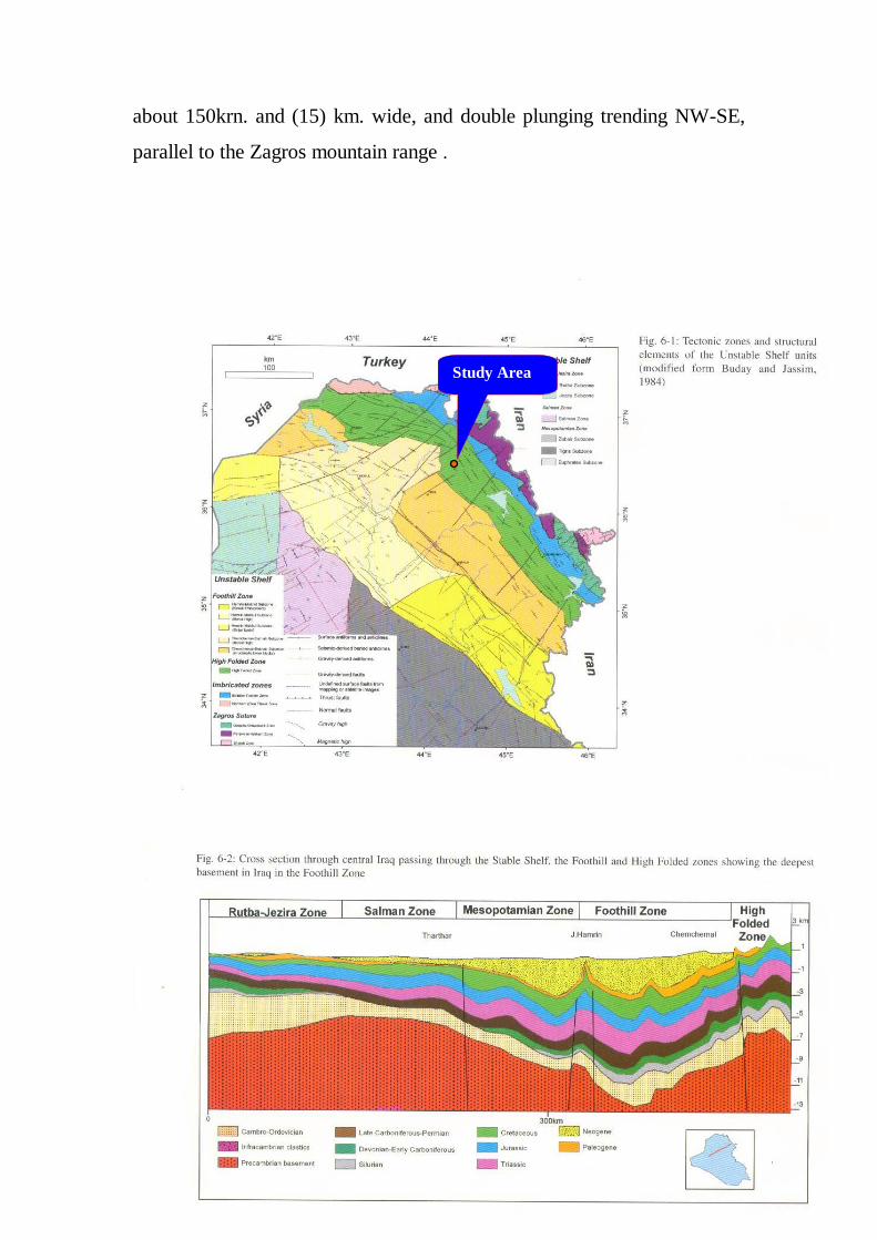
about 150krn. and (15) km. wide, and double plunging trending NW-SE,
parallel to the Zagros mountain range .
Study Area
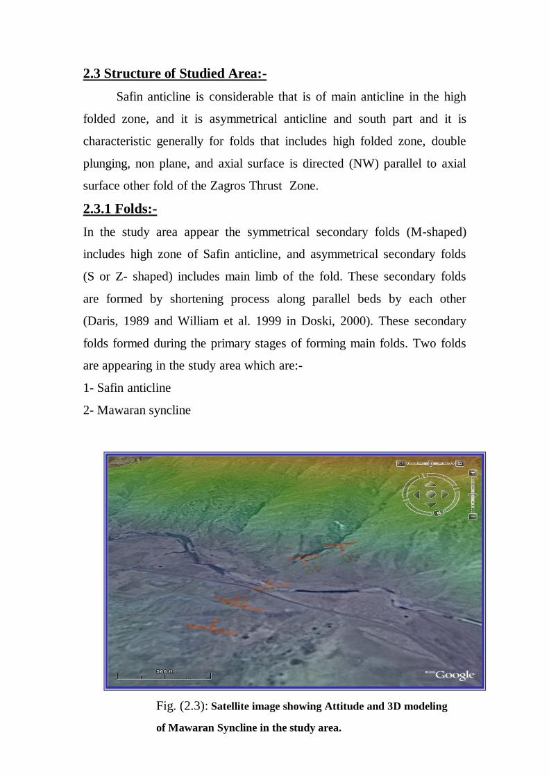
2.3 Structure of Studied Area:-
Safin anticline is considerable that is of main anticline in the high
folded zone, and it is asymmetrical anticline and south part and it is
characteristic generally for folds that includes high folded zone, double
plunging, non plane, and axial surface is directed (NW) parallel to axial
surface other fold of the Zagros Thrust Zone.
2.3.1 Folds:-
In the study area appear the symmetrical secondary folds (M-shaped)
includes high zone of Safin anticline, and asymmetrical secondary folds
(S or Z- shaped) includes main limb of the fold. These secondary folds
are formed by shortening process along parallel beds by each other
(Daris, 1989 and William et al. 1999 in Doski, 2000). These secondary
folds formed during the primary stages of forming main folds. Two folds
are appearing in the study area which are:-
1- Safin anticline
2- Mawaran syncline
Fig. (2.3): Satellite image showing Attitude and 3D modeling
of Mawaran Syncline in the study area.
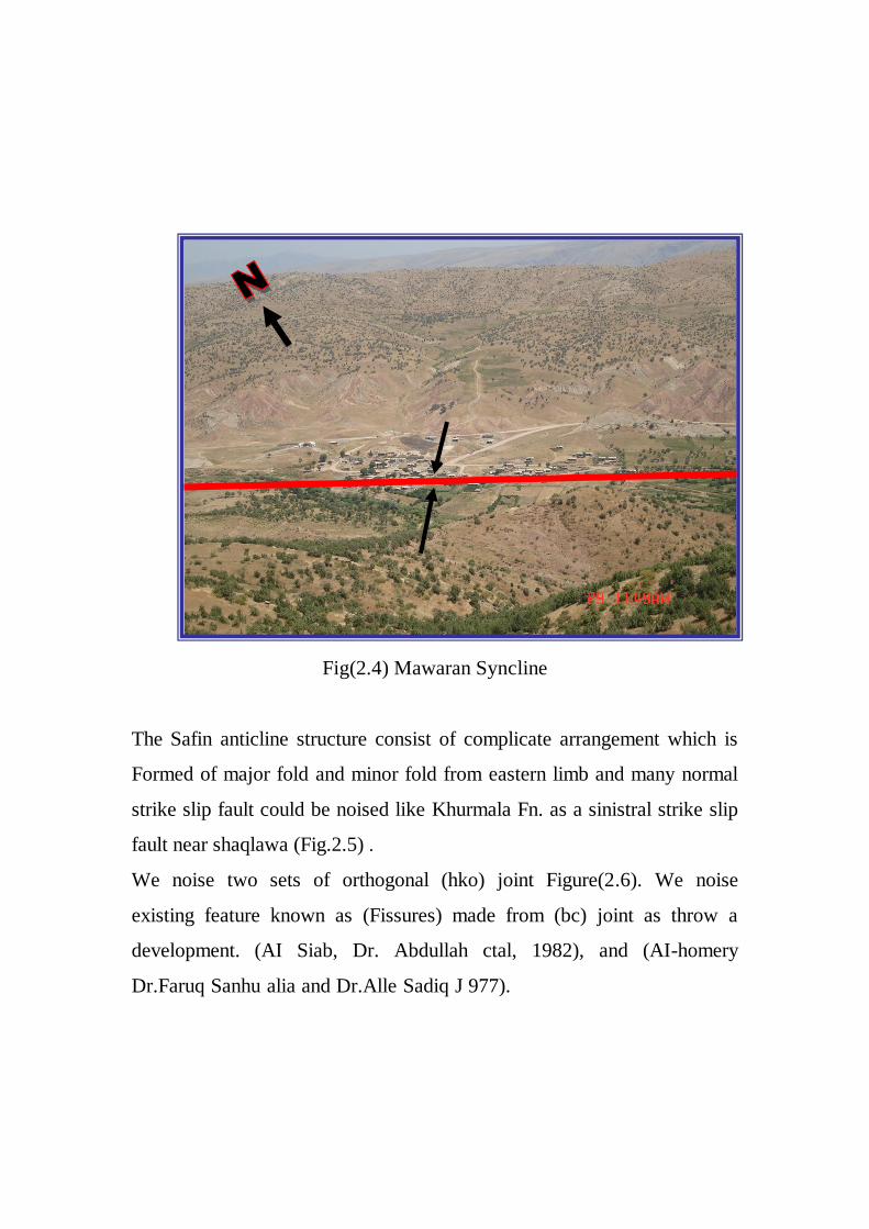
Fig(2.4) Mawaran Syncline
The Safin anticline structure consist of complicate arrangement which is
Formed of major fold and minor fold from eastern limb and many normal
strike slip fault could be noised like Khurmala Fn. as a sinistral strike slip
fault near shaqlawa (Fig.2.5) .
We noise two sets of orthogonal (hko) joint Figure(2.6). We noise
existing feature known as (Fissures) made from (bc) joint as throw a
development. (AI Siab, Dr. Abdullah ctal, 1982), and (AI-homery
Dr.Faruq Sanhu alia and Dr.Alle Sadiq J 977).
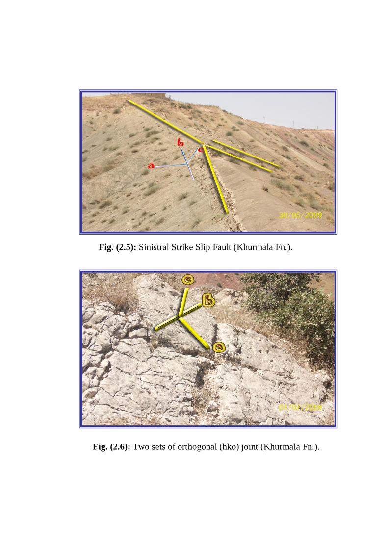
Fig. (2.5): Sinistral Strike Slip Fault (Khurmala Fn.).
Fig. (2.6): Two sets of orthogonal (hko) joint (Khurmala Fn.).
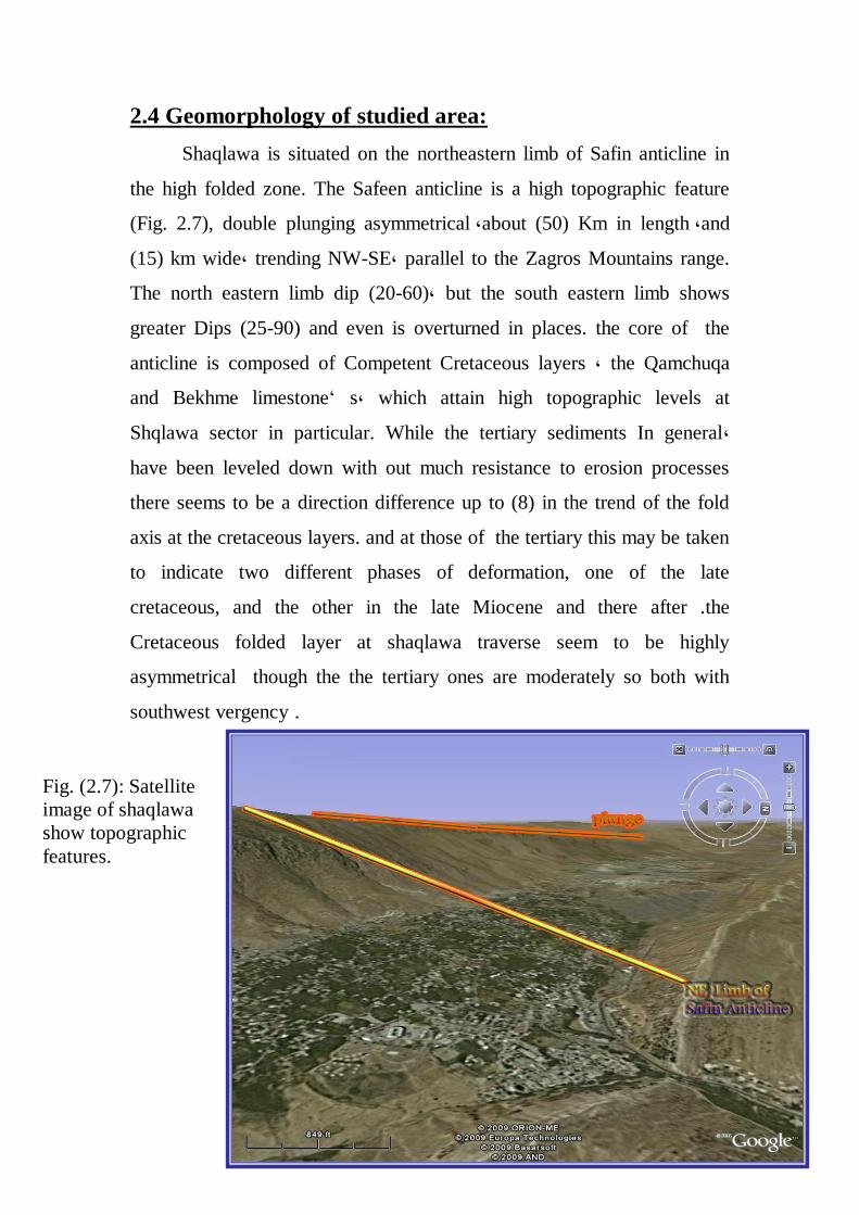
2.4 Geomorphology of studied area:
Shaqlawa is situated on the northeastern limb of Safin anticline in
the high folded zone. The Safeen anticline is a high topographic feature
(Fig. 2.7), double plunging asymmetrical ,about (50) Km in length ,and
(15) km wide, trending NW-SE, parallel to the Zagros Mountains range.
The north eastern limb dip (20-60), but the south eastern limb shows
greater Dips (25-90) and even is overturned in places. the core of the
anticline is composed of Competent Cretaceous layers , the Qamchuqa
and Bekhme limestone’ s, which attain high topographic levels at
Shqlawa sector in particular. While the tertiary sediments In general,
have been leveled down with out much resistance to erosion processes
there seems to be a direction difference up to (8) in the trend of the fold
axis at the cretaceous layers. and at those of the tertiary this may be taken
to indicate two different phases of deformation, one of the late
cretaceous, and the other in the late Miocene and there after .the
Cretaceous folded layer at shaqlawa traverse seem to be highly
asymmetrical though the the tertiary ones are moderately so both with
southwest vergency .
Fig. (2.7): Satellite
image of shaqlawa
show topographic
features.
A main longitudinal valley and several transverse ones at the Cretaceous
core of the anticline, where a parallel drainage pattern is developed, along
with karst valleys and caves. Encircling the elevated core of the Satin
anticline, are few longitudinal valleys for instance Shaqlawa valley at the
northeast, Tawska valley at the West, and Razga valley at the Northeast,
all being carved in the less resistant layer of the intermediate zone namely
Shiranish. Kolosh and Gercus Formations. 'Where they exhibit dendritic
drainage pattern.
Homoclinal ridges represented by the pila spi limestone, bound the
structure from both side forming the Sork mountain at the northeast,
Mizgawta at the south east these ridges have been transected by
transverse valleys, probably caused by major fractures that bad cut across
the whole structure. Darbandi Sork and the Shcraswar arc just two
examples of the V-shaped valleys that are formed as a result ofbrcaking
in the Pilaspi homocline ridge. Sarcand fault a dextral strike slip fault
trending NE-SW cuts a cross the Tertiary beds at the Zebarok sector, with
horizontal displacement of few hundred meters, and is thought to be
related to the Hadhr-Bekhrne fault.
The core syncline, at the southwestern limb, plunges to the SE, is
occupied by the Lf'ars layers which have been cdrnpressed on both sides,
Pirmam anticline symmetrical one, as the dip On both limbs ranges (8-
20), and the axis trending NE-SE, extending for more than (17) km. it is
composed predominantly by the ridge Pila spi formation, overlying the
argillaceous Gercus beds that are exposed near the southeastern plunge at
the northeastern limb of the Safin anticline, the Marawa syncline, is
occupied by the U, Fars and the L. Bakhtiary sediments.
CAPTER THREE
STRATIGRAPHY
3.1Preface
The stratigraphy of the studied area composed of seven formations
that all of them are out cropped, but we studied five of them which
explained below:
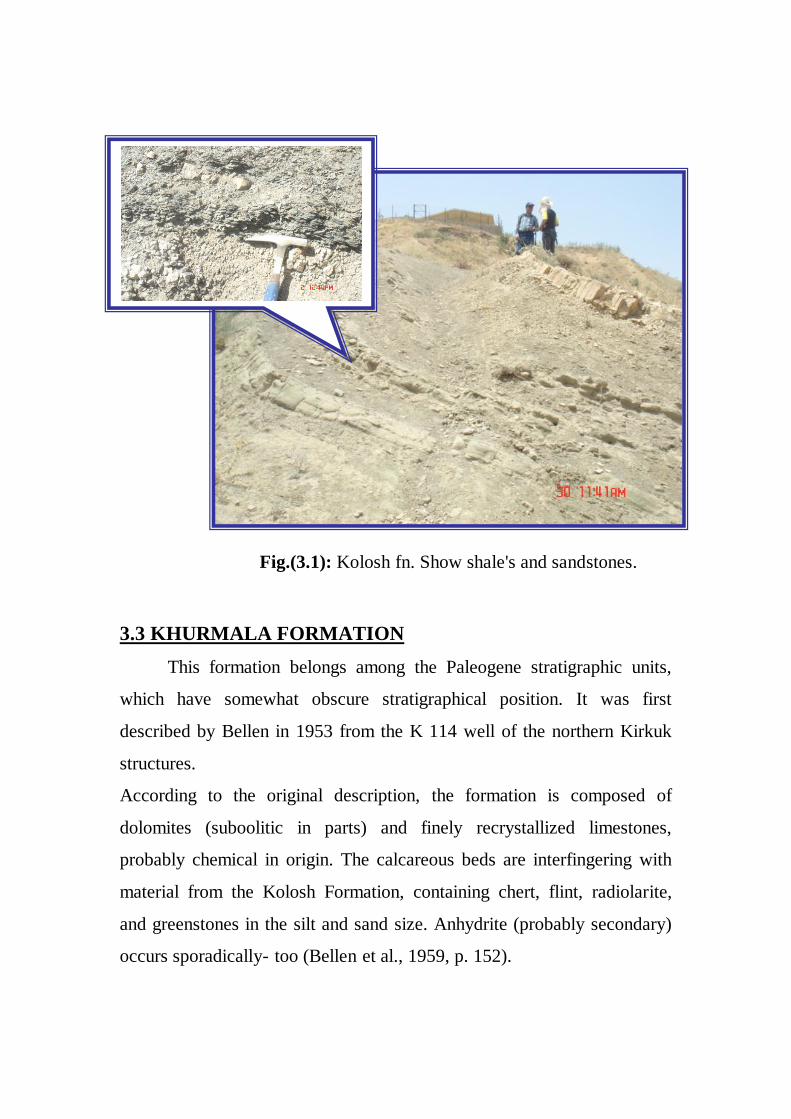
3.2 Kolosh Formation
The sediment of the deepest and most mobile sedimentary basin of
Paleocene - Lower Eocene Cycle, is connected with gradual lateral
passage with the previously described Aaliji and representing its pen
contemporaneous clastic facies. The formation was first described by
Dunnington in 1952, who designated Section at Kolosh, north of Koi
Sanjak, in the High Folaed Zone as the type area of the formation.
According to Ditmar et al. (1971, p. 84), the type section of the
form¬ation includes, in its upper parts, the Sinjar Limestone Formation
too. The lithology (prevalently limestones) and the fossils support this
statement. The formation according to the original description consists of
shale's and sandstones composed of green rock, chert, and radiolarite
(Fig. 3.1).
The upper contact of the formation is supposed to be unconformable too.
This was suggested by Bellen et al. (1959, pp, 156 and 110 – 111), but
was, in some areas, not clearly proved.
There however. In cases where the kolosh is covered by Paleocene -
Lower Eocene limestone formations, the upper boundary is conformable
and (as it is in the type area) gradational.
3.3 KHURMALA FORMATION
This formation belongs among the Paleogene stratigraphic units,
which have somewhat obscure stratigraphical position. It was first
described by Bellen in 1953 from the K 114 well of the northern Kirkuk
structures.
According to the original description, the formation is composed of
dolomites (suboolitic in parts) and finely recrystallized limestones,
probably chemical in origin. The calcareous beds are interfingering with
material from the Kolosh Formation, containing chert, flint, radiolarite,
and greenstones in the silt and sand size. Anhydrite (probably secondary)
occurs sporadically- too (Bellen et al., 1959, p. 152).
Fig.(3.1): Kolosh fn. Show shale's and sandstones.
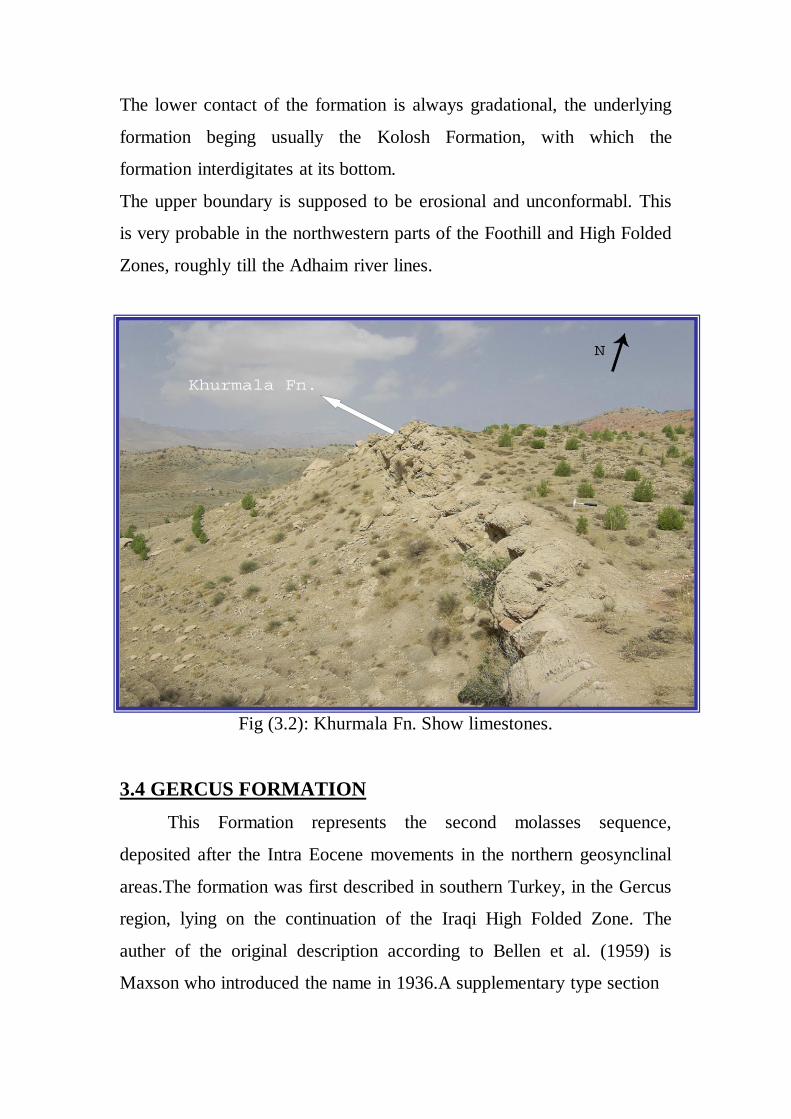
The lower contact of the formation is always gradational, the underlying
formation beging usually the Kolosh Formation, with which the
formation interdigitates at its bottom.
The upper boundary is supposed to be erosional and unconformabl. This
is very probable in the northwestern parts of the Foothill and High Folded
Zones, roughly till the Adhaim river lines.
Fig (3.2): Khurmala Fn. Show limestones.
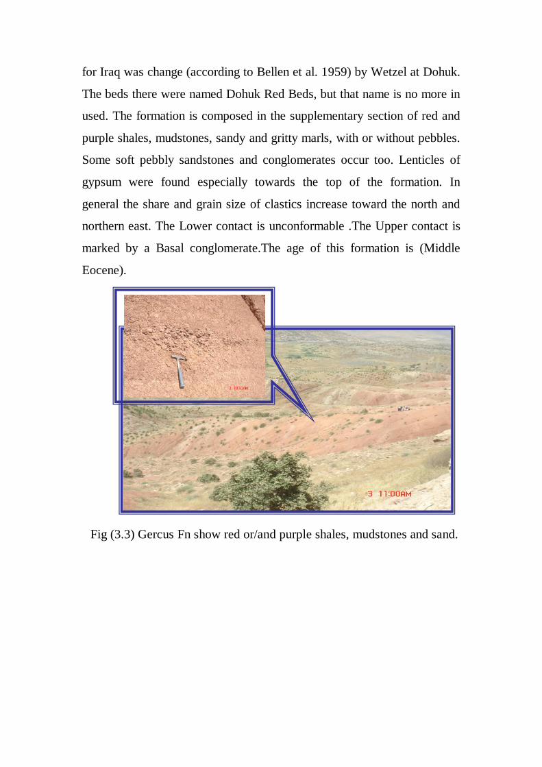
3.4 GERCUS FORMATION
This Formation represents the second molasses sequence,
deposited after the Intra Eocene movements in the northern geosynclinal
areas.The formation was first described in southern Turkey, in the Gercus
region, lying on the continuation of the Iraqi High Folded Zone. The
auther of the original description according to Bellen et al. (1959) is
Maxson who introduced the name in 1936.A supplementary type section
for Iraq was change (according to Bellen et al. 1959) by Wetzel at Dohuk.
The beds there were named Dohuk Red Beds, but that name is no more in
used. The formation is composed in the supplementary section of red and
purple shales, mudstones, sandy and gritty marls, with or without pebbles.
Some soft pebbly sandstones and conglomerates occur too. Lenticles of
gypsum were found especially towards the top of the formation. In
general the share and grain size of clastics increase toward the north and
northern east. The Lower contact is unconformable .The Upper contact is
marked by a Basal conglomerate.The age of this formation is (Middle
Eocene).
Fig (3.3) Gercus Fn show red or/and purple shales, mudstones and sand.
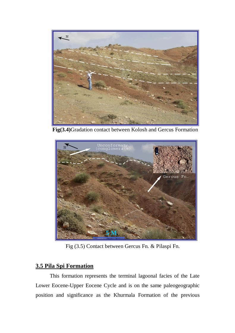
Fig(3.4)Gradation contact between Kolosh and Gercus Formation
3.5 Pila Spi Formation
This formation represents the terminal lagoonal facies of the Late
Lower Eocene-Upper Eocene Cycle and is on the same paleogeographic
position and significance as the Khurmala Formation of the previous
Fig (3.5) Contact between Gercus Fn. & Pilaspi Fn.
5 M.
cycle. The formation was first described by Lees in 1930 from the Pila
Spi area of the southeastern margins of the High Folded Zone. It was
redefined by Wetzel (1947) and amended by Bellen (1957).This
formation composed mainly of Limestone, yellowish dolomitic
limestone, marly limestone and chert nodules.The thickness of the
formation varies roughly between 100-200 m. smaller thicknesses, caused
mainly by erosion, are known in the mountainous areas too. The
formation represents an inshore, lagoonal deposit, filling in the marginal,
slightly subsiding foredeep basin. This basin was covering a slightly
broader area than the preceeding Gercus trough .Fossils are abundant.
The age of the formation is Middle and Upper Eocene. The Lower
Eocene is missing, being represented by the usually underlying Gercus
Formation. The Pila Spi Limestone Formation is correlative, as far as age,
and partly lithofacies are concerned, with the Dammam and Avanah
Limestone Formations. The main difference is the ubiquitous presence, or
even prevalent share of the lagoonal facies in the Pila Spi.
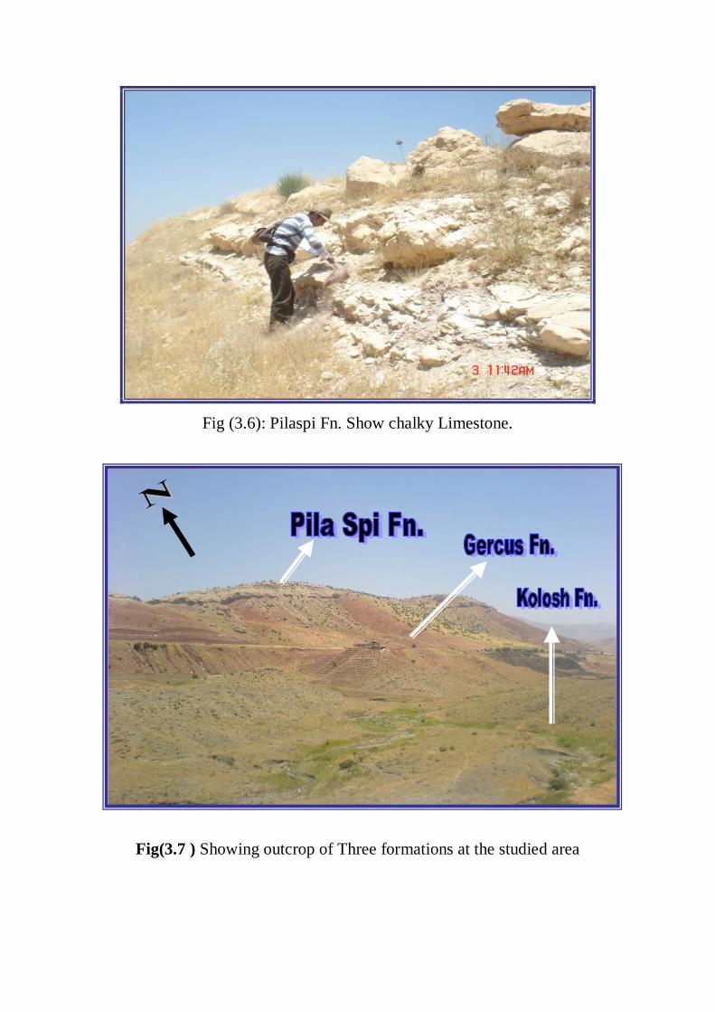
Fig (3.6): Pilaspi Fn. Show chalky Limestone.
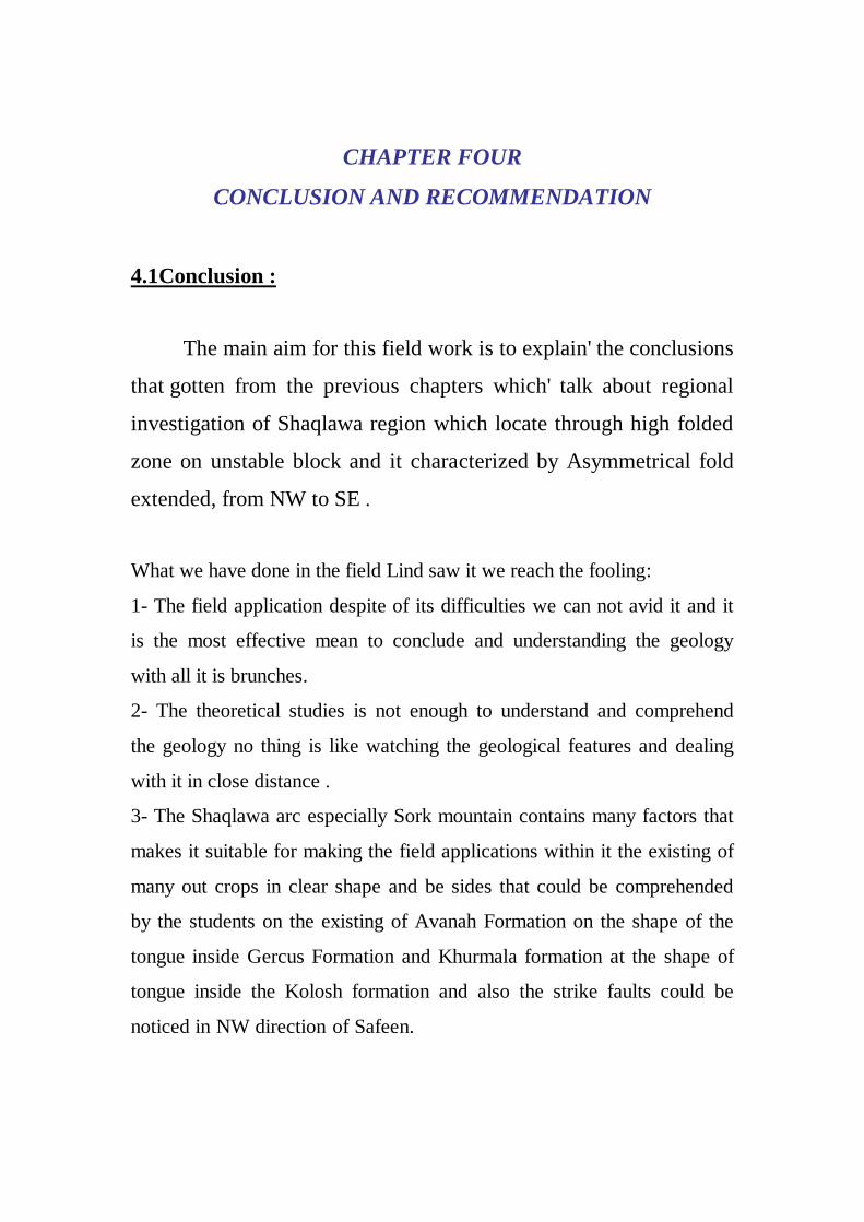
Fig(3.7 ) Showing outcrop of Three formations at the studied area

3.6 AVANAH FORMATION
This formation represents the second neritic, shoal type, limestone
unit of the late Lower Eocene - Upper Eocene Cycle The formation was
according to Bellen et al. (1959) first described by Mc Ginty in 1953
from the Kirkuk 116 well, located on the Avanah dome of the Kerkuk
anticline of the Foothill Zone. The thickness of the formation reaches its
maximum values in its type area, where it amounts to 210 m. usually the
thickness is of the same order throughout, though in areas of
interfingering, considerably lower values were ascertained.. The lower
contact of the formation is, according to Bellen et al. (1959, p. 44)
«probably» uncomfortable. This assumption was made on
paleogeographical considerations. The quoted outhors rightly claim
(1959, p. 153), that the change from the lagoonal conditions (prevailing
during the Khurmalah deposition) to the shoal fascias of the Avanah)
postulate a transgression.The upper contact isuncomfortable. The
formation is mostiy developed in areas, where the Oligocene is missing,
and mostly Middle Miocene sediments are overlying the Avanah
limstones.We saw only few meters of this formation in studied area as a
tongue within Gercus Formation.
Fig. (3.7): Avanah Formation as a tongue within Gercus Formation.
1 M.
CHAPTER FOUR
CONCLUSION AND RECOMMENDATION
4.1Conclusion :
The main aim for this field work is to explain' the conclusions
that gotten from the previous chapters which' talk about regional
investigation of Shaqlawa region which locate through high folded
zone on unstable block and it characterized by Asymmetrical fold
extended, from NW to SE .
What we have done in the field Lind saw it we reach the fooling:
1- The field application despite of its difficulties we can not avid it and it
is the most effective mean to conclude and understanding the geology
with all it is brunches.
2- The theoretical studies is not enough to understand and comprehend
the geology no thing is like watching the geological features and dealing
with it in close distance .
3- The Shaqlawa arc especially Sork mountain contains many factors that
makes it suitable for making the field applications within it the existing of
many out crops in clear shape and be sides that could be comprehended
by the students on the existing of Avanah Formation on the shape of the
tongue inside Gercus Formation and Khurmala formation at the shape of
tongue inside the Kolosh formation and also the strike faults could be
noticed in NW direction of Safeen.

4- From the economical point of view we can make use of this place to
establish the cement factory due to the existence of primitive ore material
in this place in a huge amount that makes the remaining of factory as long
as possible.
5- There are plane area, valleys, drainage patterns and cliffs .The low area
formed due to erosion process that act on the friable formations such as
(Kolosh & Gercus), but the ridges and cliffs present at Pila Spi Formation
due to high resistance to erosion process.
4.2Recommendation:
The work field area (Shaqlawa) have led to the following
recommendations:
1. Detailed tectonic study of the study area for determining the
general tectonic setting of the area and the origin locality of the
formation.
2. Detailed mineralogical study of the formations for determining its
economic minerals.
3. Detailed geophysical study of the formations for determining its
subsurface structures.
4. Detailed hydrological study of the area for determining its drainage
patterns.
Appendix
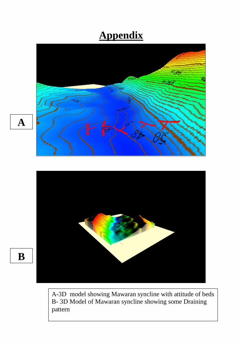
A
B
A-3D model showing Mawaran syncline with attitude of beds B- 3D Model of Mawaran syncline showing some Draining
pattern
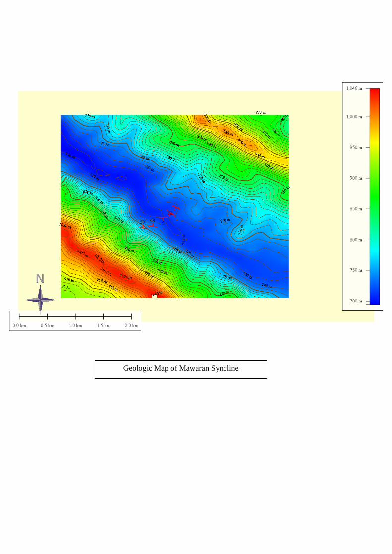
Geologic Map of Mawaran Syncline
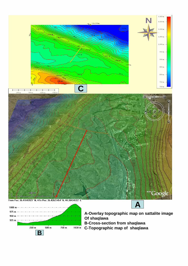
A-Overlay topographic map on sattalite image
Of shaqlawa
B-Cross-section from shaqlawa
C-Topographic map of shaqlawa
C
A
B
