advanced level geography202.82.16.155/bss/geography/notes/drainage_basin.pdftranspiration from...
TRANSCRIPT
ADVANCED LEVEL GEOGRAPHY
NATURAL LANDSCAPE: Landform System
Topic 6: Drainage Basin System –
(i) The Hydrological Cycle in the Landform
Development. (水份循環與地形發展的關係)
================================================
(I) INTRODUTION:
(A) Definition:
A drainage basin may be defined as an area of land, drained by the river and its tributaries.
Its boundary is marked by a ridge of highland beyond which precipitation from the
atmosphere falling on it eventually moves downslope to a river system.
The drainage basin is a fundamental unit of the water cycle. It is the most effective part of
water cycle in producing change in the land surface.
The region of the land drained by a particular river system is termed as River Basin. General speaking, the catchment area of a river is the River Basin. It is bounded by a watershed (water divide).

A drainage Basin can be viewed as an open system, and it form part of the
hydrological cycle. The major components are group into input, processes and output.
(System: A system is functional unit with energy and material transfer through the components of input, processes and output).
The basic function of drainage basin system is to take runoff and debris out of the catchment area.
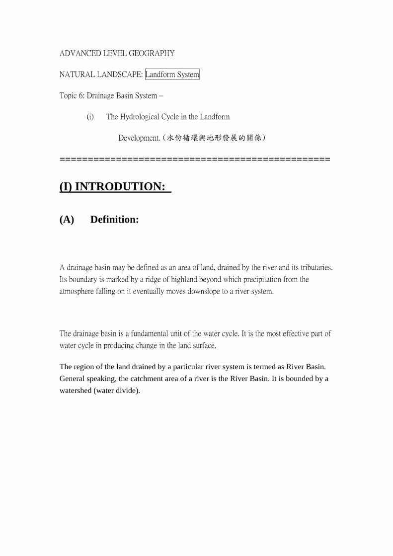
Within the system, there are different types of subsystems and elements. The drainage basin system is made up of the weathering, slope, channel and network subsystem. Together they form a cascading system – where the output from one is the input of other. One subsystem has the effect on other subsystem.
Importance of Drainage Basin:
1. Drainage Basin are basic areal units within which data on fluvial landforms and processes can be collected, organized and analyzed. In particular, they are common in the humid tropics because of the heavy precipitation and the dominance of rivers in carving out the fluvial landforms.
2. Drainage basin can be considered as an open system.
There are inputs of precipitation and solar radiation, and outputs of discharge, evapotranspiration and outgoing terrestrial radiation.
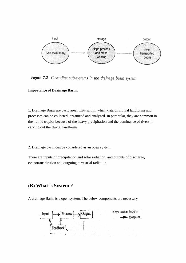
(B) What is System ?
A drainage Basin is a open system. The below components are necessary.
(An open system: There are materials lose or leave from the system.
A close system: There are no material lose from the system except energy.)
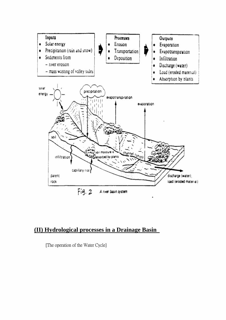
(C) Input, Process and Output in a River Basin:
In the system, there are vegetation, slope, soil, bed rock and river channel as the major parts.
(1) Input: (投入)
~ For example, climate, rock types, soil types, vegetation.
~ Materials input include rainfall(water), air, weathered rocks, and minerals.
~ Energy input is mainly come from solar energy.
~ Apart from above, slope and geological conditions of a river basin
can be regard as input too.
(2) Processes: (過程)
~ The processes in a river basin include River erosion, Transportation
and Deposition.
(3) Output: (產出)
~ include the erosional and depositional landforms in the basin
~ some materials will be transported away from the system.

~ The gradient of the basin may change by the erosional and
depositional process.
(4) Feedback: (反饋)
~ The output of the basin may affect the elements of input and
process.
~ For example, the water vapor (as a output through evaporation) can
be condensed again in the upper atmosphere inform of clouds and
precipitated again as rainfall.
~ For example, the gradient of river basin is reduced by river erosion
which in turns results the depositional process in the basin.

(II) Hydrological processes in a Drainage Basin
[The operation of the Water Cycle]
What is Hydrological Cycle ?
Within the drainage basin, there has hydrological cycle with hydrological processes.
~ The hydrological cycle describes the circulation of water from hydrosphere (ocean), atmosphere and lithosphere (land) in a great series of continuous interchanges of both geographic position and physical state.
~ Everyday, about 1,400,000 millions m3 of water are evaporated from the earth surfaces. 1,050,000 millions m3 of water reprecipitated into ocean and 350, 000 millions m3 of water reprecipitated onto lands surfaces eventually flow back into the oceans.
~ Such great water movement is driven by the solar energy (the heat derived by the earth from the sun) because this energy is necessary to bring about important changes in physical state and geographical position of the enormous amounts of water in the cycle.
~ Water exists in three states: solid (ice), liquid (rain) and gas (water vapor). The water is ever moving round through a series of processes called the Water Cycle.
General speaking, water cycle describes the movement and storage of water among four main sectors of the earth system.
a. the atmosphere
b. the biosphere
c. the lithosphere
d. the hydrosphere
Thus water cycle itself is a closed system, because no material is lost.
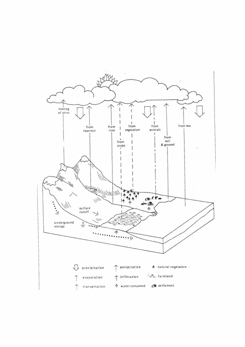
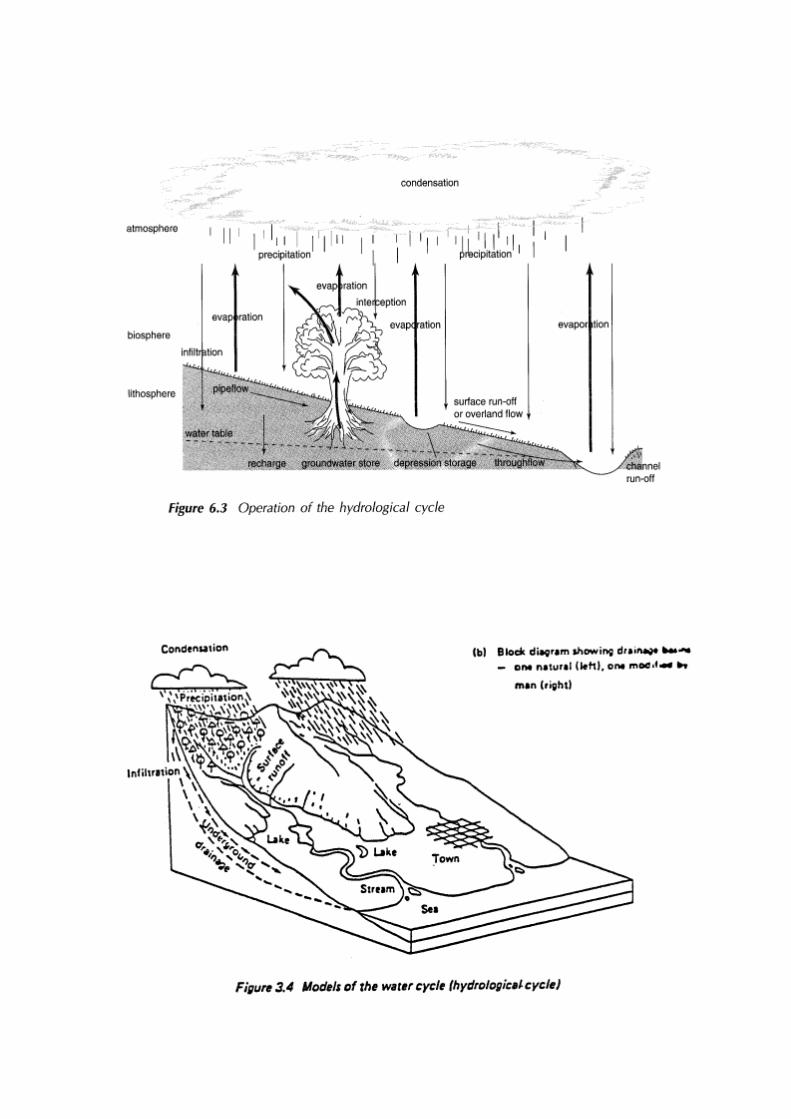
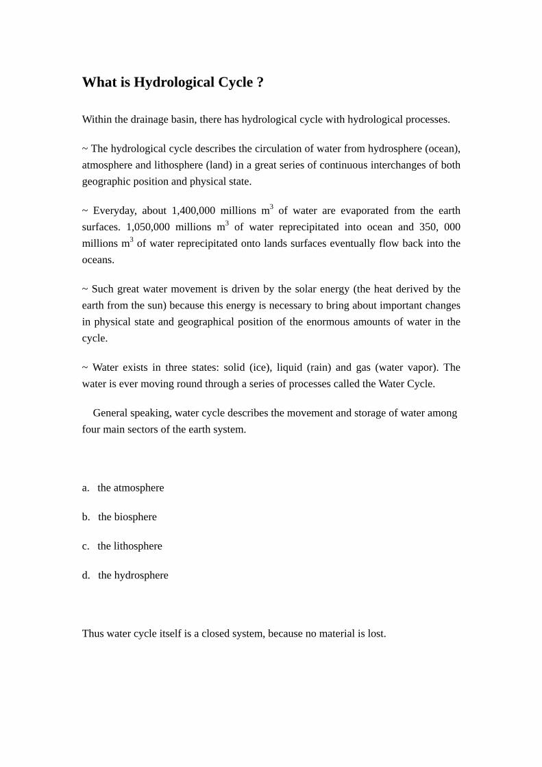
The Hydrological processes within a drainage basin.
With reference of the above diagram, describe the operation of Water
Cycle:
~ When water is in hydrosphere, water is evaporated into atmosphere.
~ In the atmosphere, water is in gas form and can be condensed to form precipitation.
~ The precipitation can either return to hydrosphere to complete a simple water cycle or enter the biosphere and lithosphere.
~ When the precipitation enter the biosphere and lithosphere, water may leaves the landscapes by one of the two routes:
(1) it forms runoff, makes its way to the ocean and is eventually evaporated into the atmosphere.
(2) it may be passed directly back to the atmosphere, due to evaporation or transpiration from leaves of plants back to atmosphere.
~ By the condensation and precipitation processes, water is back to the biosphere and lithosphere, thus form the simple water cycle.
~ The largest water cycle in the World is the water in the hydrosphere (sea) is evaporated by solar Energy and enter the atmosphere to form precipitation in the lithosphere and biosphere. After the water enter the lithosphere and the biosphere, water will form surface runoff (e.g. river), underground water back to the hydrosphere. Also, some of the water will be stored in the biosphere and lithosphere and back to atmosphere by evapotranspiration.
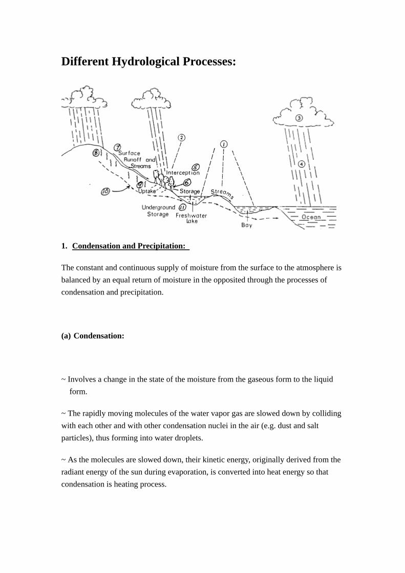
Different Hydrological Processes:
1. Condensation and Precipitation:
The constant and continuous supply of moisture from the surface to the atmosphere is balanced by an equal return of moisture in the opposited through the processes of condensation and precipitation.
(a) Condensation:
~ Involves a change in the state of the moisture from the gaseous form to the liquid form.
~ The rapidly moving molecules of the water vapor gas are slowed down by colliding with each other and with other condensation nuclei in the air (e.g. dust and salt particles), thus forming into water droplets.
~ As the molecules are slowed down, their kinetic energy, originally derived from the radiant energy of the sun during evaporation, is converted into heat energy so that condensation is heating process.
~ Condensation occurs when the temperature of the air falls to a level known as dew point, which may be defined as the temperature at which the air is 100% saturated with water vapor. Rain drops are formed around condensation nuclei. Cloud is formed. As the raindrops become bigger and bigger, precipitation occurs.
(b) Precipitation:
- Applied to all forms of moisture (e.g. rain, snow, hail, frost) which reach the earth from the atmosphere.
- Occurs when cloud droplets (0.01mm in diameter) are coalesed to form rain drops (0.2mm in diameter) and become too heavy to be suspended.
- The annual precipitation intensity, amount and seasonality (the length of the humid season and the portion of annual precipitation total falling in the humid season) are the determinants of the amount of discharge in a river within the river basin.
- Tropical thunderstorms downpours are often very localized, i.e. the effect is limited on the scale of individual catchment. However, steady depressions rainfall may affect extensive drainage basins.
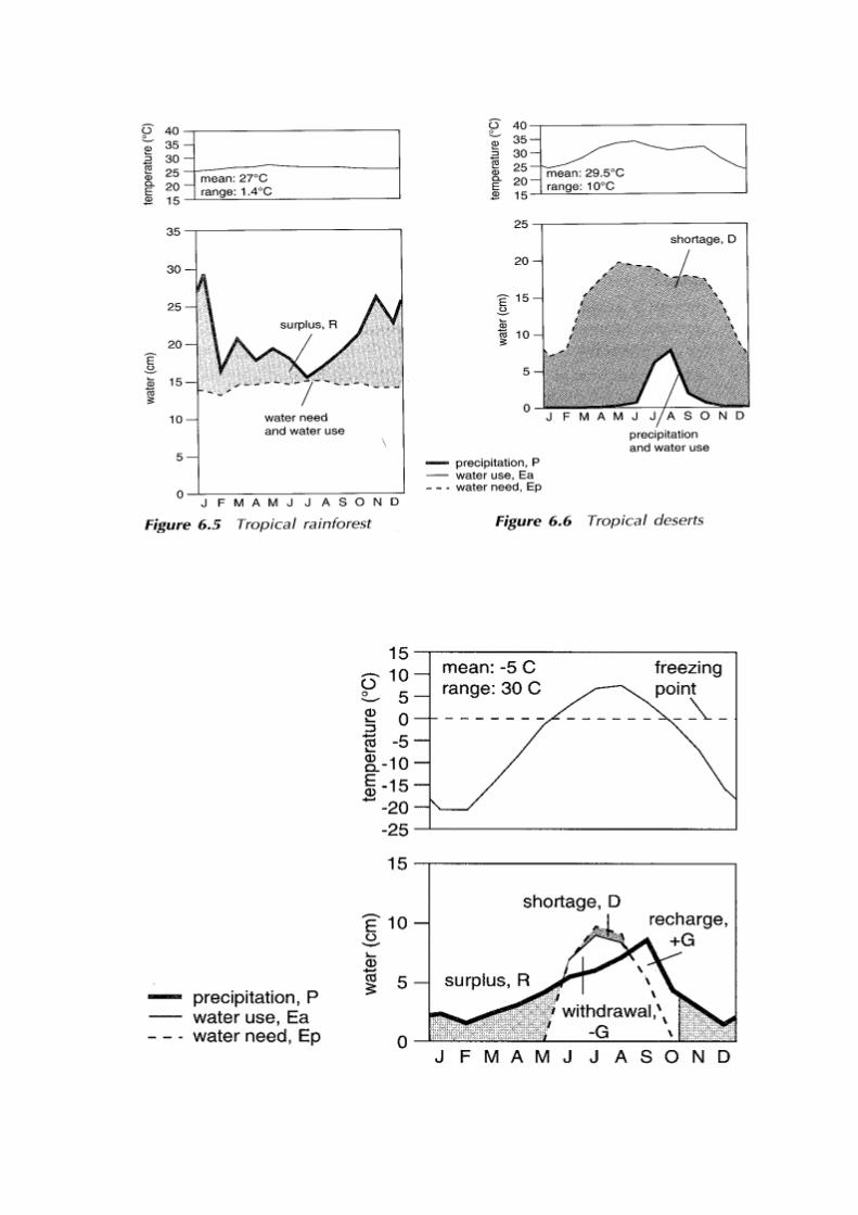
- In the tropical rain forest:
~ it has hot, humid climate and the precipitation is heavy – over 2000 mm per year. As warm air is uplift and becomes unstable, cumulonimbus clouds are developed.
- In the tropical desert:
~ it has hot, arid climate and the precipitation is small – less than 250 mm per year. As warm air is sink and becomes stable under the subtropical high pressure belt, sky is clear with no clouds are developed.
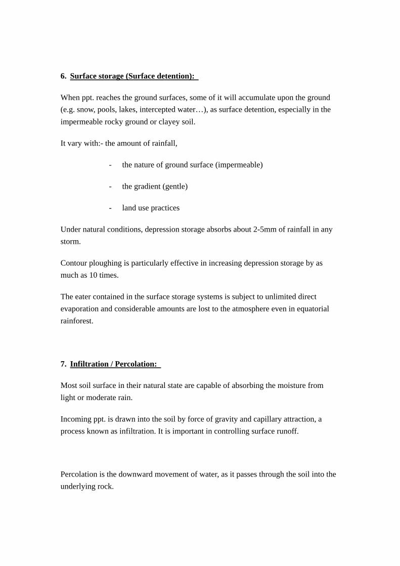
- In the tundra forest:
~ it has cold climate and the annual precipitation is low – between 250mm and 500mm, in form of snow, which had little effect on surface hydrological processe
The melting of snow is slow and hence only a small amount of water is contributed to the drainage basin.
2. Interception:
Vegetation are capable of catching/ trapping (intercepting) incoming ppt. and can store water temporarily before they finally reach the ground.
If the ppt. continues, the storage spaces of leaves and branches become filled and water drips through the canopy as throughfall.
Water will also reach the ground surface by running down trees trunks as stemflow.
Factors affecting interception:
(a) Extent of vegetation cover (density):
~ if the vegetation cover is denser, the amount of interception will be increased.
~ e.g. the amount of interception is higher in tropical rainforest (30%
of this precipitation). However, the savanna can only get 15 % of the
precipitation.
(b) Types of vegetation:
e.g. forest can intercept more ppt. than grass cover.
(c) Duration, magnitude and amount of rainfall:
Duration of storm:
~ if the storm lasts a short time, a considerable proportion of the
rainfall remains caught on the leaves and branches, this is called
interception storage.
~ if the storm lasts for long period, the amount of interception will
be increased. However, the ability of absorption of the vegetation
will be decreased because the body of the vegetation is wet enough.
Magnitude of storm:
~ if the magnitude (intensity) of the storm is great, the amount of
interception will be smaller.
Amount of storm:
~ if the amount of the storm is great, the amount of interception
will be decreased.
In other words, precipitation falling onto a vegetated area can follow three possible routes:
~ reaching the ground as throughfall in between the space unoccupied by branches, stems and foliage of plants.
~ being caught by the branches, stems and foliage of plants and eventually reaching the ground as stemflow.
~ being caught by the branches, stems and foliage of plants and returned directly to the atmosphere by evaporation.
- In the tropical rain forest,
~ much of the precipitation does not fall directly onto the ground,
making interception by the dense vegetation the highest amongst the
world’s landscapes.
- In the tropical rain forest,
~ the sparse vegetation means that the interception is very small.

Most precipitation reaches the ground directly.
- In the tundra,
~ the sparse and low height of vegetation also means there is little
interception.
P.S: The low interception rates of tropical deserts and tundra lead to a high proportion of water being available (80-100%) for surface hydrological processes. However, the actual amount of water available in tropical deserts and tundra is very low because of the low precipitation rate and also the quick of conversion of snow into hard ice in the tundra.
3. Transpiration: (T)
Plants draw the moisture into their systems through vast networks of tiny rootlets.
This water, after being carried upward through the roots and stems into leaves, is discharged in the form of water vapor, through leaf pores (stomata) into atmosphere. It is called transpiration.
In other words, this is the excretion of water which has been absorbed by roots and is produced as the water products of metabolism by plants. It takes place at the stomata or minute openings at the undersides of leaves.
Transpiration represents a loss of water needed for the reduction of body temperature and excretion of harmful metabolic wastes by plants. Its rate of occurrence is dependent on:
- Temperature: higher temperature increases the moisture holding capacity
of the air, reducing relative humidity and speeding up plant
metabolism.
- Relative humidity: which is in turn governed by solar radiation and
the amount of moisture found in the air.
- Wind speed
- Size and number of stomata
- Leaf size
- Seasonal growth
- In the tropical rain forest,
~ the sparse vegetation acts as a large reservoir. Water is taken up
from the soil by vegetation during photosynthesis. Large amounts of
water vapor are returned to the atmosphere by transpiration.
- In the tropical desert,
~ the sparse vegetation are xerophytic, that is. They can store water
in their tissue and transpiration is small.
- In the tundra, due to the low temperature, sparse vegetation growth
results in low transpiration.

4. Evaporation: (E)
~ “Evaporation involves in state of the moisture from liquid form (water)
to the gaseous state (water vapor).”
~ “The radiant energy provided by the sun causes the molecules of water in
the liquid form to move about more rapidly. These activated molecules
eventually move fast enough to break free from the liquid surface and
pass into the atmosphere in the gaseous state. In doing so, they take
with them their energy of molecular motion called kinetic energy. The
temperature of the remaining liquid is lowered by the removal of energy,
and it may be considered as a cooling process. Each year, some 360,000km3
of water are evaporated from the oceans and seas into the atmosphere.”
This is the change of liquid water into water vapor on exposed surfaces such as soil, foliage and water bodies by the action of solar radiation. Like transpiration rates, evaporation rates are dependent on
- temperature,
- relative humidity : the ability of the air to accept water vapor.
- wind speed
- (vegetation: evaporation rates are higher where the evaporation cover is denser, e.g. a larger amount of water is intercepted by leaves and will eventually be lost through evaporation).
- In the tropical rain forest,
~ the rate of evaporation , though high, is lower than TD
because of the cloud cover reduces the energy input.
- In the tropical desert,
~ evaporation rate is high due to clear sunny skies and low
relative humidity.
- In the tundra,
~ the evaporation rate is low because of the low temperature.
5. Evapotranspiration (ET)
This is the compound loss of water by direct evaporation from water on the surface of vegetation, soil and lands, and from transpiration from plants.
It represents the sum of water loss from both plant and other sources.
It is dependent on meteorological factors such as duration of direct sunshine, solar energy flux, wind speed and air moisture content.
Two forms of evapotranspiration:
(a) Potential evapotranspiration (Ep):
- the maximum amount of moisture that can be lost from the soil by
evaporation and transpiration if there is a continuous supply of
water to the soil to make up for the losses.
- such conditions apply under irrigation or in the very wet equatorial
land.
(b) Actual evapotranspiration (Ea):
- the actual amount of soil moisture lost to the atmosphere by plants
and soil.
- this loss is limited by the amount of moisture available in the soil
and is less than the potential loss.
Although the water deficits and water surplus in the soil are important for plant growth, they also affect the level of water available for surface hydrological processes. The relative amounts of water can be estimated from soil-moisture budget graphs.
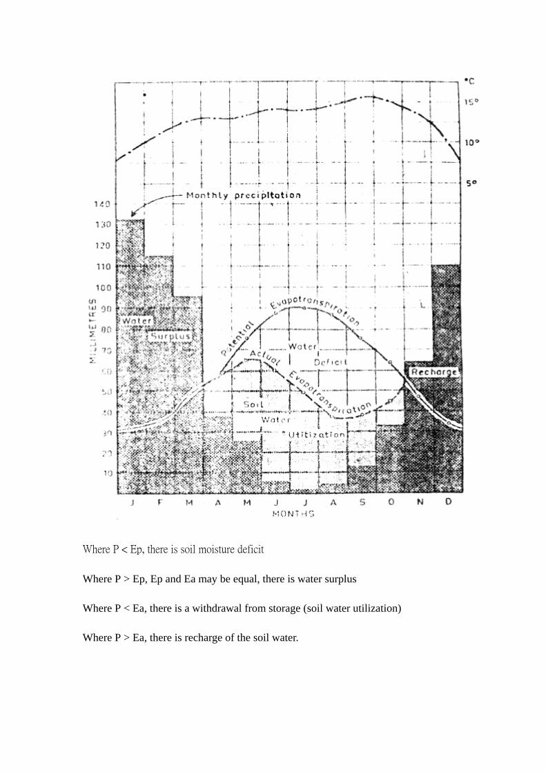
Where P < Ep, there is soil moisture deficit
Where P > Ep, Ep and Ea may be equal, there is water surplus
Where P < Ea, there is a withdrawal from storage (soil water utilization)
Where P > Ea, there is recharge of the soil water.
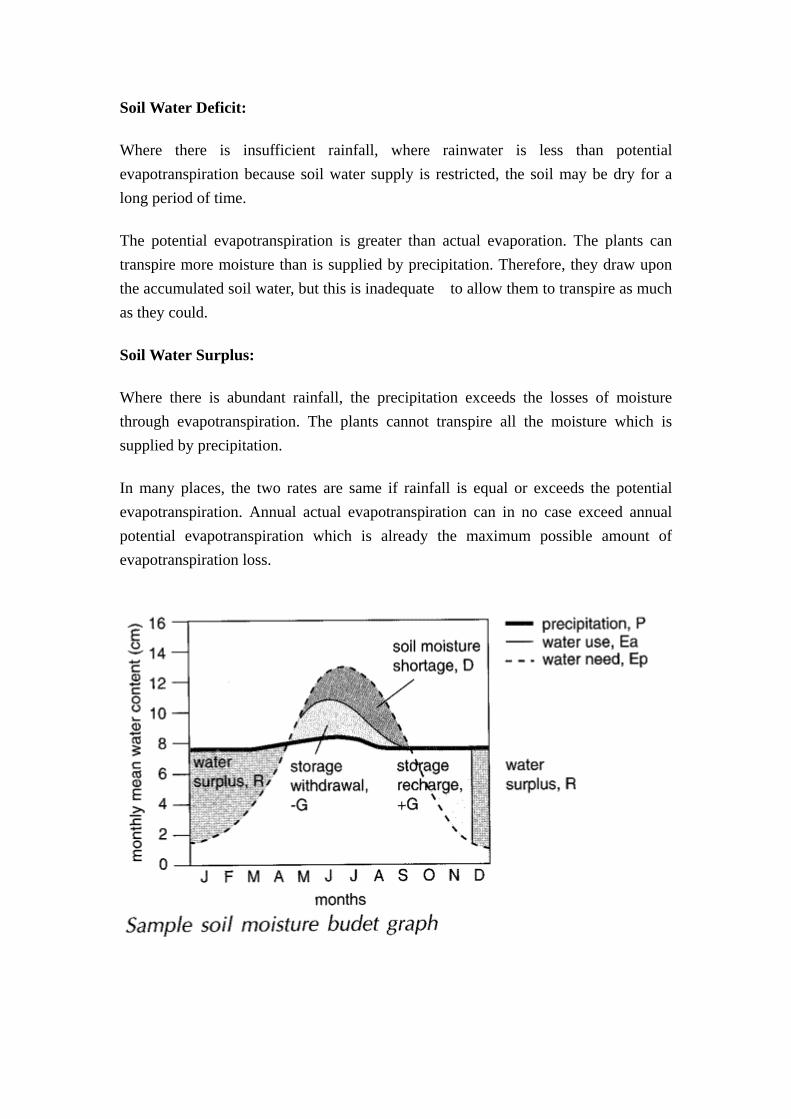
Soil Water Deficit:
Where there is insufficient rainfall, where rainwater is less than potential evapotranspiration because soil water supply is restricted, the soil may be dry for a long period of time.
The potential evapotranspiration is greater than actual evaporation. The plants can transpire more moisture than is supplied by precipitation. Therefore, they draw upon the accumulated soil water, but this is inadequate to allow them to transpire as much as they could.
Soil Water Surplus:
Where there is abundant rainfall, the precipitation exceeds the losses of moisture through evapotranspiration. The plants cannot transpire all the moisture which is supplied by precipitation.
In many places, the two rates are same if rainfall is equal or exceeds the potential evapotranspiration. Annual actual evapotranspiration can in no case exceed annual potential evapotranspiration which is already the maximum possible amount of evapotranspiration loss.
6. Surface storage (Surface detention):
When ppt. reaches the ground surfaces, some of it will accumulate upon the ground (e.g. snow, pools, lakes, intercepted water…), as surface detention, especially in the impermeable rocky ground or clayey soil.
It vary with:- the amount of rainfall,
- the nature of ground surface (impermeable)
- the gradient (gentle)
- land use practices
Under natural conditions, depression storage absorbs about 2-5mm of rainfall in any storm.
Contour ploughing is particularly effective in increasing depression storage by as much as 10 times.
The eater contained in the surface storage systems is subject to unlimited direct evaporation and considerable amounts are lost to the atmosphere even in equatorial rainforest.
7. Infiltration / Percolation:
Most soil surface in their natural state are capable of absorbing the moisture from light or moderate rain.
Incoming ppt. is drawn into the soil by force of gravity and capillary attraction, a process known as infiltration. It is important in controlling surface runoff.
Percolation is the downward movement of water, as it passes through the soil into the underlying rock.
Precipitation which has managed to reach the ground without suffering interception and subsequent direct evaporation will infiltrates into the ground until the saturation point is reached.
The soil infiltration capacity is usually great at the start of rain that has been preceded by a dry spell. However, it drops rapidly as the rain continues to fall and soak into the soil. After several hours, the soil’s infiltration capacity become almost constant.
When rain falls, water infiltrate or percolate through successive layers of the soil:
(1) The soil water belt (zone of aeration)
~ closest to the ground surface and the space in the subsoil is not always
filled up. There is free movement of water through this zone upward and
downward.
(2) Intermediate belt (zone of aeration)
~ it is saturated only after long periods of rain.
~ occurs even in the rainforest regions, but has more water than the soil water.
(3) Groundwater belt (zone of saturation)
~ usually lie close to the bed of the weathering profile.
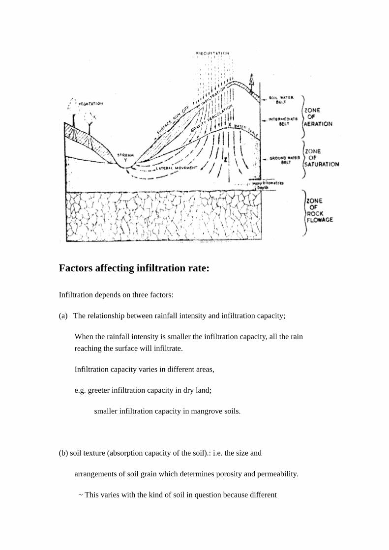
Factors affecting infiltration rate:
Infiltration depends on three factors:
(a) The relationship between rainfall intensity and infiltration capacity;
When the rainfall intensity is smaller the infiltration capacity, all the rain reaching the surface will infiltrate.
Infiltration capacity varies in different areas,
e.g. greeter infiltration capacity in dry land;
smaller infiltration capacity in mangrove soils.
(b) soil texture (absorption capacity of the soil).: i.e. the size and
arrangements of soil grain which determines porosity and permeability.
~ This varies with the kind of soil in question because different

soils tend to have different rates of porosity and the permeability.
Soils which are rich in sand tend to have lower porosity and higher
permeability than soils rich in clays.
(p.s. Porosity(孔隙度) : amount of pore space that it contains;
= Volume of voids in the materials
Bulk volume of the materials
Permeability(滲透率) : the ease with which water can move through a
given soil type. This is affected by the shape,
packing, and uniformity of grain size)
(c) Initial moisture content (antecedent soil moisture condition):
= Initial drier soils tend to have higher infiltration rates than already
soaked soils. This is because soil particles, especially clay, tend to

become more sticky and swell whenever wetted such that the pore spaces
may become sealed. Moisture still present in the soil from a previous
rain will tend to lower infiltration capacity
= Extreme dryness where the soil surface is compacted, will lower the
ability to absorb water.
Infiltration Rate (mm/hr) Initial moisture content % Good grass cover Poor weed cover
0-14 18 6
14-24 7 4
24 + 4 3
(d) The time from the start of a rain – infiltration rate are high in the first ten minutes or so after the start of a rain but gradually decreases with time and ultimately reach small constant values an hour or more late.
(e) Presence of absence of near-surface impermeable subsoil or rock layer.
Infiltration is checked by the presence if impermeable layer lies next the surface, (e.g. tropical deserts: cliché; tropical rain forests: duricrust;
Tundra, permafrost). Precipitation cannot percolate or infiltrate for more than a few meters at most. Infiltration is neglected on rocky or stony surfaces (such as rocky deserts or stony deserts) although there may be some minor pores, crevices in the rock through which water can pass.
(e) Vegetation cover:
Grasses, ground herbs helps infiltration by
- preserving loose soil structure by roots of plants,
- diffusion the flow of water, increasing infiltration opportunity,
- break the impact of raindrops,
- protect the soil surface from the compaction of soil particles by raindrops.
The bare soil surface will be exposed to the direct raindrop impact of the rain drops. The rain drop will compact the soil and also wash small particles into the open cracks and holes. This has the effect of reducing infiltration as rain continues.
(f) Angle of slope:
On a steep slope, water moves rapidly over the surface and hence has
little time to infiltrate, whereas on flat surfaces or depressions
water is detained until it evaporates or infiltrate.
(g) Animals:
infiltration takes place through the pores in between soil particles,
deep openings along plant roots and cracks opened by earthworms and
termites. Such openings may however, be more or less compacted and
sealed off if rainfall intensity is too great and if the soil is clayey
in texture.
- In the tropical rain forest,
~ the soil is permeable due to the loosening of the topsoil by
numerous plant roots. Water infiltrates into the soil forming a
large storage reservoir.

- In the tropical desert,
~ sandy deserts have the highest infiltration rates because of the large number of macro-pore spaces. Storage is usually at great depth, therefore water is not generally available to vegetation. In stony or rocky deserts, infiltration is negligible.
- In the tundra,
~ the tundra soils have the lowest infiltration rate because of their thinness and the permafrost near the soil surface.
8. Soil Water Storage:
~ The water stored in the soil is the soil water storage
~ soil is composed of minerals and organic particles. The spacing or voids
between the particles can store water and influence the water movement.
~ when infiltration occurs during heavy and prolonged rains, the water is
drawn downward by infiltration through pore-holes, wetting successively
lower layers.
~ when soil has been saturated by water and allows no more water to move
downward, it is said to be holding its field capacity. This takes no more
than 2 or 3 days for most soils.
~ field capacity of a given soil depends on its nature:
Clay soil: - has very high field capacity (porosity = 45 %)
- take a long rain periods to reach field capacity, because
infiltration (permeability) is slow and the total quantity
required to be absorbed is great (higher porosity).
Sandy soil:- has lower field capacity (porosity = 35 %)
- take a short rain periods to reach field capacity, because
infiltration (permeability) is fast and the total quantity
required to be absorbed is smaller (lower porosity).
9. Throughflow / Interflow:
Throughflow: (表層流)
When there is a decrease in permeability at the underlying parent material, water tends to start moving downslope within the soil. Such downslope flow of soil water is called throughflow.
This is the downslope seepage or movement of moisture through the B horizon of soil beneath a slope. On a vegetated surface, more of the precipitation seeps into the soil than runs on the ground. It takes much more time for the infiltration water to reach water table; rather, most of the water remains within the soil layer and seeps through the soil layer in a direction more or less parallel to that of the slope surface above. Throughflow ends up in rivers and hence is an important source of river discharge.
Because of the downward infiltration and upward evaporation, no moisture occurs in A horizon. Throughflow occurs mainly in the B horizon, taking a duration of 1 to 2 days to reach peak discharge after a rainstorm. Its rate of movement depends on soil texture (relative percentage of sand, silt and clay), gradient of the surface slope, evaporation rate and density of root growth in horizon B).
Interflow: (間層流)
Lateral movement of water within the parent rock above the water table.

It is increased by the presence of an impermeable layer which limits percolation to the water table and force the water to move laterally.
10. Baseflow (基本徑流)/ Groundwater flow (地下水流):
This is the very slow downslope movement of underground water at water table level to where weathered rock and unweathered bedrock meet. Underground water moves downslope at this depth because the bedrock beneath is impermeable.
In other words, at some depth beneath the surface, the rock will be saturated and the ground water zone is called aquifer.
Although it is a very slow process because of the discontinuity of cracks in the bedrock, baseflow or groundwater flow in a steady contributor of water to river channels. Because of the obstruction of bedrock and large weathered rock debris, any rise in baseflow after a rainstorm can only be very gradual and cannot be felt until several weeks later.
Underground water is important because it serves as a regular supply of water to channel system. However, it is not in direct water supply to plants.
11. Overland flow / Runoff
According to Horton, overland flow which occurs when rainfall intensity is so great that not all the water can infiltrate. It is the gravitational movement of water over the
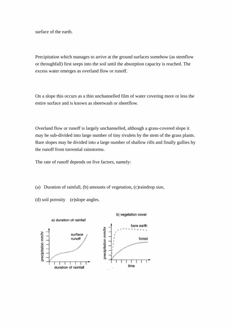
surface of the earth.
Precipitation which manages to arrive at the ground surfaces somehow (as stemflow or throughfall) first seeps into the soil until the absorption capacity is reached. The excess water emerges as overland flow or runoff.
On a slope this occurs as a thin unchannelled film of water covering more or less the entire surface and is known as sheetwash or sheetflow.
Overland flow or runoff is largely unchannelled, although a grass-covered slope it may be sub-divided into large number of tiny rivulets by the stem of the grass plants. Bare slopes may be divided into a large number of shallow rills and finally gullies by the runoff from torrential rainstorms.
The rate of runoff depends on five factors, namely:
(a) Duration of rainfall, (b) amounts of vegetation, (c)raindrop size,
(d) soil porosity (e)slope angles.
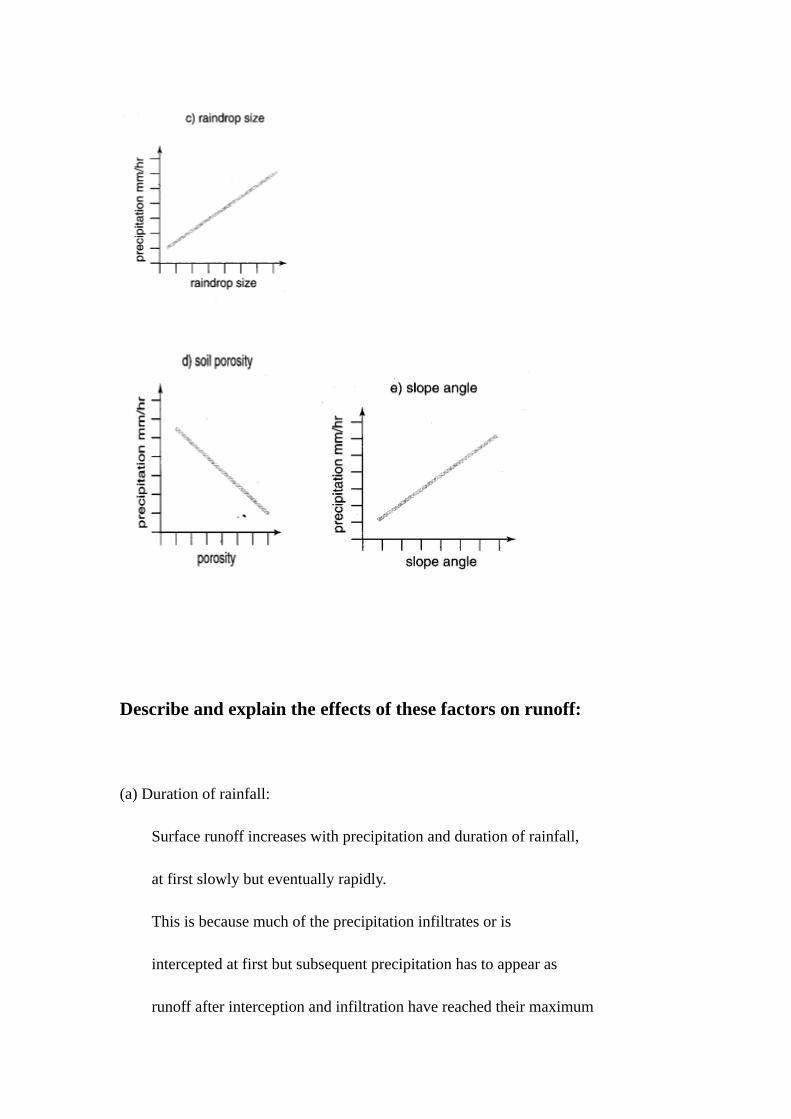
Describe and explain the effects of these factors on runoff:
(a) Duration of rainfall:
Surface runoff increases with precipitation and duration of rainfall,
at first slowly but eventually rapidly.
This is because much of the precipitation infiltrates or is
intercepted at first but subsequent precipitation has to appear as
runoff after interception and infiltration have reached their maximum

capacity and saturation level.
(b) Amounts of vegetation:
Runoff on bare slopes rises more rapidly with precipitation than
runoff on forested slopes.
This is because vegetation can intercept a substantial amount of water
and make the soil more permeable to infiltrating water, thus reducing
the amount of runoff available for runoff.
Besides, vegetation promotes infiltration by promoting better soil
texture and thick layer. As infiltration increased, runoff decreased.
(c) Raindrop size:
Surface runoff increased with precipitation and raindrop size. This is
because larger raindrops, common during heavy precipitation, are less
easily intercepted by plant leaves and cannot infiltrates easily into
finer soil pores.
(d) Soil porosity:
Surfaces runoff decreases with decreases in precipitation and increase
in soil porosity.
This is because with less precipitation there will be less water
available for runoff. With increased soil porosity more of the

precipitation water will infiltrate and become unavailable for runoff.
(e) Slope angle:
Surface runoff increases with precipitation and slope angles.
This is because with more precipitation there will be more water
available for runoff. On steeper slopes less water infiltrates and
water runs more quickly downslope.
(For more factors, refer to p.113-115, “A-Level Geography Notes” by Teresa Law.)
- In the tropical rain forest,
~ it has the largest amount of water available for surface
hydrological processes. This is because of the high precipitation
which keeps the soil saturated, and the soil water surplus.
- In the tropical desert,
~ Although there is shortage of rainwater, river channels can still
be found in stony and rocky desert. This is because rainfall in
deserts is often torrential and the infiltration rate of stony
and rocky desert surfaces is low,
- In the tundra,
~ despite a shortage of rainwater, surfaces may be swamped
with water in the early summer. This is because by then, the
surface ice cover has melted, but the meltwater cannot sink into
the ground because of the permafrost beneath.
12. Channel flow
Water falling within a drainage basin arrives at the basin floor and
becomes concentrated into channel flow. The stream or river which
eventually drains the water out of the basin is supplied with water
from four sources: (a) direct channel precipitation,
(b) surface runoff from slopes on the two sides of channel
(c) throughflow / interflow
(d) groundwater flow
(e) snow melts – adds more water to runoff
Importance of water cycle:
(a) Water, in one form or another, plays a major role in most of the
processes that influence the various phenomena in the natural
environment:
- As atmospheric moisture – an important element of weather and climate
- It affects the rate of chemical & biological weathering.
- It affects the rate and types of slope processes.
- It affects the rate and type of channel flow and fluvial processes.
- All plants depends on water, and vegetation growth and patterns are influenced by the availability of water.
- The amount of moisture moving through the soil influences chemical reaction in the soil, as well as its profile development.
- Contribution to the salinity of seas and oceans.
- Water, in its various form(e.g. rain, ice and waves() is largely responsible for the variety of landforms through its role as an agent of earth sculpture.
(b) Within the drainage basin, precipitation and solar insolation are capable of producing weathered debris within a drainage basin. Both unchannelled surface runoff and channelled river flow can remove the weathered materials and changing the shape of the slopes and surfaces through which they pass. The effects of weathering, slope processes and channel processes are outlines in the next topics.
Water Balance (Global water cycle):
- Within the hydrosphere, water is neither created or destroyed. Since the
total amount of water is constant, there must be a continuous cycling of
water from 1 form of storage to another. The cycling starts and runs non-
stop because of energy from the sun.
- Within the drainage basin, it is a simple input-output analysis of the
drainage basin as a single unit.
- It assumes that total volumes of water input and output must ultimately
be equal if no cumulative change of water held in the basin taken place.
P = ET + RO (discharge)
- the water balances equation must be correct over infinitely long time
period.
- for the finite time of any experiment, the volume of water stored in the
basin may change, therefore:
P = ET + RO changes in storage
= ET + RO SWS GWS DS GWO
SMS – soil moisture storage
GWS – Groundwater storage
D S – Depression storage
GWO – Groundwater flow
~ Hence, on the global scale, the hydrological cycle is a closed system
except that energy is added to provided a motive force.
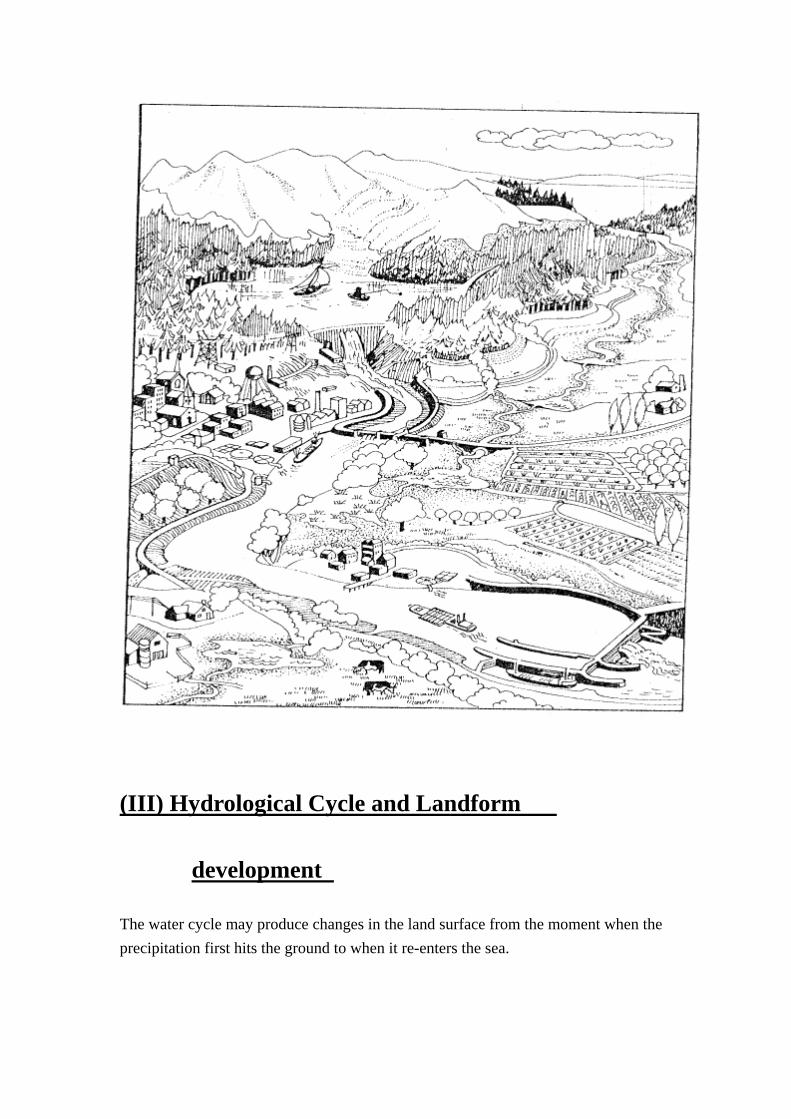
(III) Hydrological Cycle and Landform
development
The water cycle may produce changes in the land surface from the moment when the precipitation first hits the ground to when it re-enters the sea.
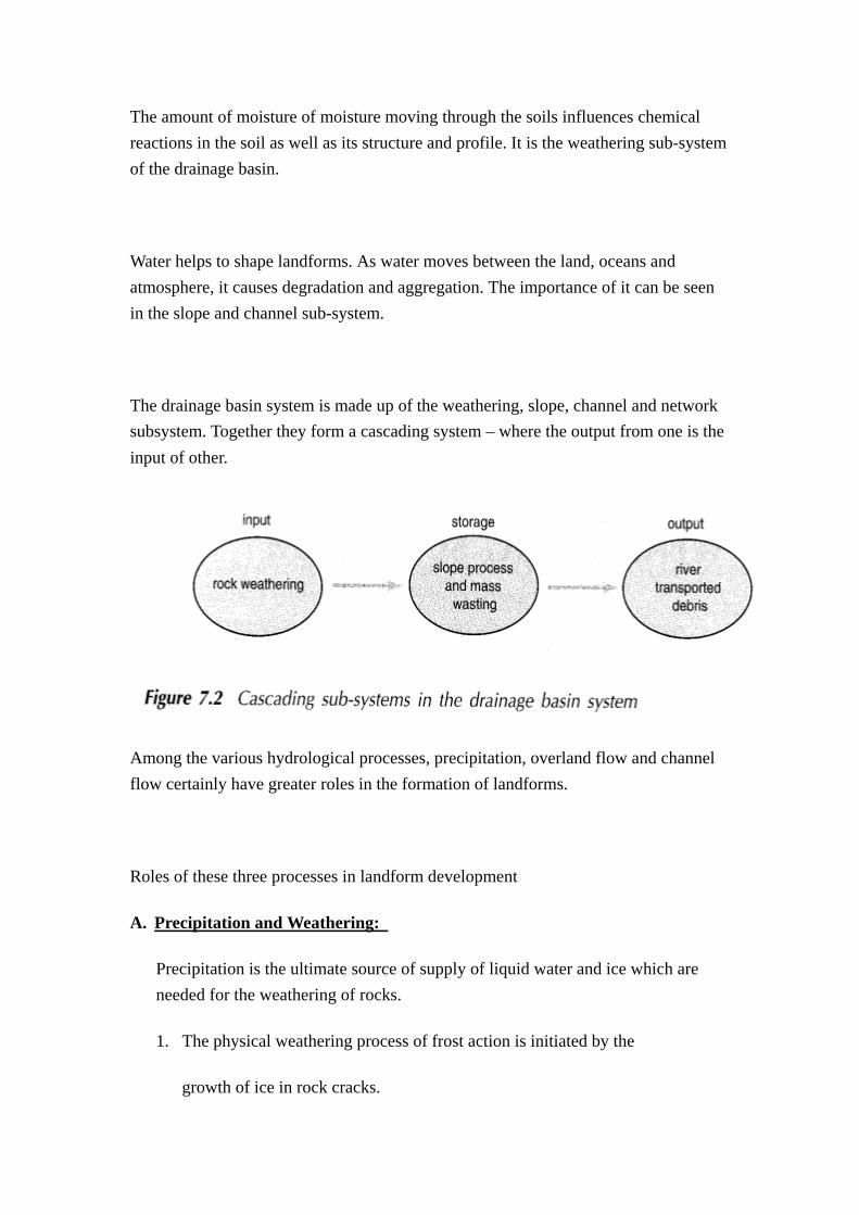
The amount of moisture of moisture moving through the soils influences chemical reactions in the soil as well as its structure and profile. It is the weathering sub-system of the drainage basin.
Water helps to shape landforms. As water moves between the land, oceans and atmosphere, it causes degradation and aggregation. The importance of it can be seen in the slope and channel sub-system.
The drainage basin system is made up of the weathering, slope, channel and network subsystem. Together they form a cascading system – where the output from one is the input of other.
Among the various hydrological processes, precipitation, overland flow and channel flow certainly have greater roles in the formation of landforms.
Roles of these three processes in landform development
A. Precipitation and Weathering:
Precipitation is the ultimate source of supply of liquid water and ice which are needed for the weathering of rocks.
1. The physical weathering process of frost action is initiated by the
growth of ice in rock cracks.
2. Liquid water found on rock surfaces and topsoil cause chemical
weathering in four ways: --
~ Hydrolysis, which is a reaction between a mineral and water
~ Hydration, which is the taking up of the water molecule (H2O)
into the rock mineral.
~ Carbonation, which is the reaction between carbonic acid
(formed by the combination of carbon dioxide and water) and
carbonate minerals *such as calcium carbonate in limestone)
~ Biological weathering which is indirectly related to but
dependent on the supply of rainwater that is needed for the
growth of plants and animals.
B. Overland flow and Slopes
Overland flow, while derived from precipitation, is the process which
produces changes to slopes. The main ways by which overland flow causes
changes to slopes are :--
1. Landslides occurring along straight glide planes after slopes have
become over-saturated with rainwater.
2. Slumps occurring as rotational movements along a curved slip planes.
3. Flow occurring as movements of weathered masses on clayey slopes by internal deformation. Flow takes three forms – earthflows (which are rapid flowage of saturated soil masses). Mudflows (which are less rapid downslope
of slows of a moisture of water and mineral fragments), and solifluction (which are very slow movements of the seasonally thawed layer over tundra slopes underlain by permafrost).
4. Surface wash by which surface weathered debris is eroded by water running on the slopes. Sheetflow (which occurs as a thin continuous layer of water eroding fine and medium sized particles on vegetated slopes receiving high intensity rains) and raindrop splash (which causes a net downslope movement of soil through the impact of raindrops) are two common forms of surface wash.
C. Channel flow and stream sub-system:
Water entering into channels moves towards the outlets of drainage basins because of the force of gravity.
The geomorphical outcomes of this movement are the erosion or the removal of weathered debris from the channel perimeter (beds or floor), the transportation of weathered debris along with the channel flow towards the lower course, and the deposition of weathered debris at the bottom and along the two sides of the channels. Spatially, the ways in which these three outcomes are accomplished can be detailed as follows:
1. River erosion:
(a) Hydraulic action – the dislodgement of the unconsolidated material through the impact of moving water.
(b) Abrasion – the wear and tear of rock particles forced to strike at or being dragged along the channel bed.
(c) Solution – carbonic acid carried in the river or stream dissolves carbonate rocks (such as limestone).
(d) Attrition – reduction in size of the particles in transport as they strike at one another or the channel bed.
(2) Transportation:
Material eroded or detached from the channel perimeters carried
downstream by the moving river water in three ways:
(a) Suspension : turbulence caused by water movement makes it possible
for fine particles (such as silt and clay) to move forward without
sinking to the floor of the channel.
(b) Traction : larger particles like sand and gravel roll and slide along the channel bed under the force of forward moving river water.
(c) Saltation – small particles like sand and gravel bounces and jump forward along the channel bed under the force of forward moving river water.
(d) Solution – minerals soluble in river water are carried downstream in dissolved form.
(3) Deposition:
Rivers lay down their suspended load and bedload upon reaching plains or other flat surfaces because river velocity is substantially reduced by small channel gradients or the upstream surge of tidal water.
Given that in the long run the amount of water input into a drainage
basin is a fixed quantity, the amount of water involved in channel flow
is of great hydrological and geomorphological importance. This is because
it affects the amount of water lost from the drainage basin and the
amount of erosional, transportation and depositional work due to the
channel and its adjacent basin floor.
(IV) Water Cycle in Selected Regions
(1) Water cycle in tropical rain forest:
~ Equatorial rain forest areas experience hot and humid climate. Inputs in the form of precipitation is high, more than 2000mm per year. Rate of evaporation though high is lower than it could be because cloud cover reduces energy input. Uplift of warm, moist, unstable air caused by convergence of tropical air masses and aided by convection and orographical uplift produces towering cumulus clouds when condensation takes place due to rising air cooling and becoming saturated.
~ Much precipitation does not fall directly to the ground but is intercepted by dense vegetation cover—some of the intercepted rain evaporates into the atmosphere but most reaches the ground by direct throughfall and by running down trunks or dripping off branches.
~ Vegetation acts as large storage reservoir within the water cycle. Water is absorbed by vegetation during photosynthesis and by uptake from the soil reservoir. Large amounts of water vapor are returned to the atmosphere by transpiration.
~ Water reaching the ground either infiltrates into soil or flows across surface as runoff into streams and lakes. Much water is evaporated from these surfaces and returned to the atmospheric sector.
~ Water infiltrating into soil forms a large storage reservoir available to plant roots. Moisture extracted from this reservoir by plant roots is transported up to the biosphere sector where it may be retained in the form of plant tissue or returned to the atmospheric sector by transpiration.

(2) The Water Cycle in Desert Landscapes:
- Desert areas experience hot, dry climate. Inputs in form of precipitation is low which average less than 250mm. It is due to the general subsidence and stable conditions. Evaporation rates are high because of clear, sunny skies which gives high energy input and prevailing low atmospheric water content.
- Sparseness of vegetation cover means that interception of precipitation is very small because precipitation reaches the ground directly. Plant are xerophytic and are adapted to retain moisture. Thus water storage in plant tissue and transpiration area small components in the total balance.
- Most precipitation reaching the surface infiltrates into upper layers or more commonly flows across surface as runoff. Rainfall is often intense though of short duration. Thus, it produces sheet flow with little surface storage in lakes. Moreover, water is rapidly evaporated and returned to atmospheric sector due to the high energy input, hot surface and low humidity.
(3) COMPARE & CONTRAST THE WATER CYCLE IN TRF /DESERT /
TUNDRA
Tropical Rain Forest Tropical Desert Arctic Tundra
A. Processes in the Atmosphere
1. high energy input and
annual mean of temperature
1. high energy input and annual
mean of temperature about 18℃
1. low energy input and cold
throughout the year with
winter average -30℃ and

(21 ℃– 27℃)
2. high evapotranspiration
rates
3. condensation and
precipitation occur
frequently, because it is at
the rising arms of Hadley
Cells and ITCZ.
4. So annual Rainfall is great
(> 1500mm), some reaches
3000 – 4000 mm, and it is
evenly distributed.
5. There is no distinct dry
season.
2. high temperature and clear sky
and windy conditions, so that
there is high evapotranspiration
rates.
3. condensation and precipitation
seldom occurs as it is located at
the sinking arms of the Hadley
cells. RH is reduced.
4. So annual rainfall is < 250mm
(unreliable, variable, localized,
or sudden short-lived heavy
downpour).
summer max. < 10℃.
2. Evapotranspiration is relatively
slow.
3. Condensation and precipitation
seldom occur due to the sinking
air mass. RH is reduced.
4. Annual precipitation is <
250mm and in snow form.
B. Processes in the Biosphere
1.Dense vegetation, so that much of
the rainfall is intercepted. Only
some reach the ground directly.
There is much throughfall,
leaf-flow and stemflow.
2.Dense vegetation so large
infiltration compared to rainfall
intensity. Only some become
surface runoff.
3.There is dense vegetation so that
takes up by much moisture from
1. sparse/little vegetation so
little interception and most
rainfall reach the ground
directly.
2. Little vegetation means little
infiltration compared to
rainfall intensity.
Most rainfall becomes rapid and
erosive due to the absence of
vegetation. The rainfall comes as
sporadic heavy downpour. The
flash flood is erosive.
1. Small vegetation so little
interception and most
precipitation reaches the ground
directly.
2. Rainfall is small and in snow
form. Since there is also
permafrost so no infiltration and
runoff. In winter, precipitation
stores as snow on surface and in
summer it forms surface runoff.
In summer, it thaws and forms
seasonal stream flow, available
the soil all the year. So, vegetation
forms a large storage in the water
cycle.
4.Due to rapid evapotranspiration,
large amount of water on ground
and vegetation return to
atmosphere through
evapotranspiration.
3. Little vegetation so vegetation
forms a small storage in the
water cycle.
4. Through potential
evapotranspiration rate is rapid,
actual evapotranspiration is not
important because of little
vegetation and plants which are
xerophytic in nature, so little
moisture return to atmosphere
by transpiration.
for plants to uptake.
3. Little vegetation so vegetation
forms a small storage in the
water cycle.
4. Transpiration is not important
because of low temperatures,
little vegetation and plants
which are xerophytic in nature.
C. Process in the Lithosphere
1. Due to large infiltration and
percolation so large
underground water. The
ground water table is usually
high.
2. Some of it become throughflow
and underground flow, i.e. base
flow of rivers.
3. Some store as underground
water.
4. Some are uptaken by plants and
return to atmosphere by
evapotranspiration or store in
plant tissues.
5. Some is stored as soil
moisture, lakes in marshes
and swamps.
1. Most underground water come
from exotic sources and is too
deep for plants.
2. Due to little infiltration, so little
throughflow and underground
flow, so few permanent rivers.
3. Plants uptake moisture from
runoff and store in tissue and
little moisture return to
atmosphere by transpiration.
1. Underground storage is not
available to plants because it is
in solid state (permafrost) so
plants suffer from physiological
drought.
2. Due to low temperature and
permafrost, there is no
throughflow and underground
flow so no permanent rivers.
Rivers only occurs in summer
occasionally.
3. Vegetation uptake melt water
and store in tissue. Little
moisture is returned to
atmosphere as vegetation are
xerophytic in nature.
CASE STUDY: SHEET FLOODS AND STREAM FLOOSS
of DESERT
These two forms of runoff tends to be marked in desert with encrusted impervious surfaces. They are not always catastrophic in effect.
Sheetflood (first termed by McGee)
1. Sheetflood is a broad sheet of storm-borne water which moves partly in a system of small, shallow & shifting streamlets (rills).
2. Occurrence: It occurs on the top of flat plateau surfaces, or on desert plains, when streamfloods emerge from the mountains or when heavy rain falls on it. The sheet of water is thickest on the rock pediment.
3. Sheetflood is not uniform in thickness all over but is possessing an intricate network of high-velocity of rills in which water is moving at different speeds.
4. Conditions for the development of sheetfloods:
~ rapid rainfall on a bare surface of debris rock materials,
whereby runoff water becomes heavy loaded almost immediately.
5. Sheetflood in humid regions is usually referred to as sheetwash
or rillwash.
In arid regions, sheetflood becomes almost immediately fully
loaded with debris.
In humid regions, vegetation (e.g. grasses, forest areas) helps
retain the weathered materials. If the debris is rich in clay,
sheetflood may gradate into highly viscous mudflow.
6. Geomorphological work of sheetflood:
(a) According to W.M.Davis, sheetflood is an important transporting agent (but not an eroding agent) as it is responsible for moving large amount of debris from uplands to gentle slopes (pediment) that often borders them in deserts.
(b) Depositional debris by sheetflood is responsible for the flatness of large area of desert plains.
Streamflood (first termed W.M. Davis)
1. Rainfall in deserts is usually of high intensity is brief in occurrence and highly localized in distribution.
2. In deserts, percolation is checked by steep slopes or encrusted surface. Most of the rainfall is available as runoff. It readily enters the dry stream courses. Besides, during a heavy rain, immediate evaporation is not very high because of saturated air.
3. In most of the time, desert stream course are dry, although there may be a movement of water as underflows through the sands and gravels at the bottoms of their river beds.
4. Streamfloods rise very rapidly in mountain regions. These flows are termed streamfloods, rather than streams because of their irregular and violent flow and the fact they take a few hours to attain the maximum volume of flow and then subsides.
5. The Geomorphological Work of streamfloods:
(a) Large amounts of debris due to weathering and wind action
accumulate in the valleys during the long dry periods. Yet
they do not build up to high levels as to choke the valleys
because of the streamfloods.
Debris of all sizes from clay particles to boulders are moved
until eventually they reach the uplands edges and spread out
as alluvial fans.
(b) Streamflood can also causes erosion of stream channel themselves, and thereby carve out deep branching wadies which could bee made possible by streams with normal flow patterns.
(c) Streamflood in deserts are more important than floods of humid regions because so little river erosion between floods.
(d) Lateral abrasion of wadis channels is also due to streamfloods. This is the process eventually widens up the wadis floors.
[END]