biogeomorphology of sierra nevada streams and...
TRANSCRIPT

http://sierra.sfsu.edu
BBiiooggeeoommoorrpphhoollooggyy ooff SSiieerrrraa NNeevvaaddaa SSttrreeaammss aanndd MMeeaaddoowwss

Biogeomorphology of Sierra Nevada
Streams and Meadows June 28-July 5, 2019
Erth/Geog 643. The focus of this seven-day class is understanding the complex interactions of hydrologic and biogeomorphic systems on streams and meadows in the northern Sierra Nevada, and learning field methods for assessing stream function as they respond to long-term impacts related to glacial history and short-term human impacts of timber extraction, road construction, and grazing. We'll apply process-based and morphometric field methods to study the effectiveness of various stream and meadow restoration methods, and assess the effectiveness of projects on meadow hydrology, soils, vegetation, and species habitat. Protecting and restoring watersheds is a
growing public concern as we attempt to balance California’s needs for more water, less floods and greater resource protection. Field methods in fluvial geomorph-ology and related hydrologic processes will be explored in streams and watersheds within easy striking
distance of the field camp: (1) the North Yuba River, which flows through the Field Camp, provides a perfect setting for studying unregulated flow and the significance of hydrologic processes in bedrock and alluviated stream channels; (2) the Feather River watershed, including the nearby Sierra Valley, is a critical contributor to California water
resources, and has seen 150 years of cumulative impacts from logging, grazing, mining, forest fires and road building; and (3) tributaries of the Little Truckee River such as Sagehen Creek, where more than 60 years of stream gauge data allows us to observe the connections between streamflow and channel geomorphology. We’ll explore channel responses to impaired watershed functions and the challenges of implementing successful natural restoration projects in these watersheds. We'll use Excel, GPS, GIS, and photogrammetric software in the lab to process data and imagery from drones and other platforms. Instructor: Jerry Davis, SFSU Professor and a specialist in watershed geomorphology. We'll also spend a day with a restoration project specialist from Feather River Coordinated Resource Management, and a USGS hydrologist at the Sagehen Creek stream gauge. This class will present moderately technical information. Prospective students are strongly urged to have taken an introductory physical geography or physical geology course. The first class meets right after dinner on the first day Friday June 28. We wrap up on Friday, July 5, mid-day. **Note: more than half of this class will be held outdoors; rain, snow or shine. Storms are common in this region so participants should be prepared for any weather condition. Participants should use either hip waders or river shoes (e.g. tevas) for investigating channel elements.
To get more details about this class please email Jerry Davis at [email protected]. For registration materials, contact: J.R. Blair [email protected]
June - August: 530-862-1230
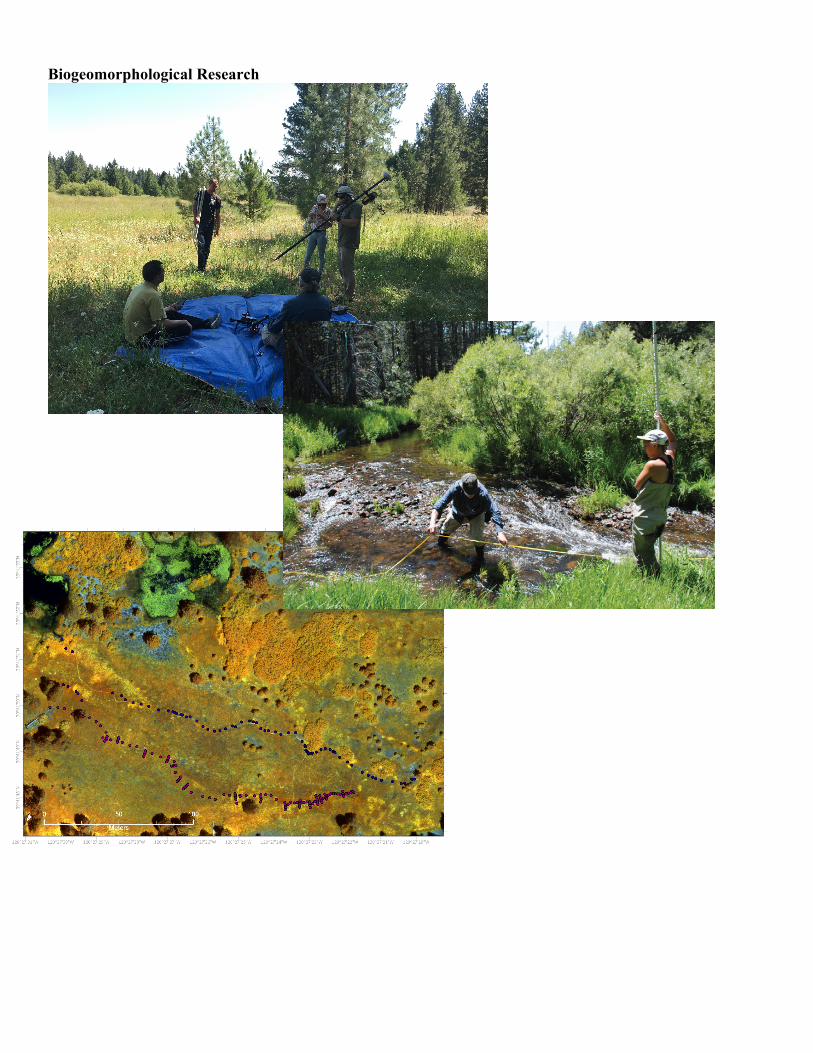
Biogeomorphological Research

Schedule Earth Science/Geog 643, Sierra Nevada Field Campus
Date Time Topic/Activity Reading 6/28 Fri
pm Orientation & introduction, just after dinner
6/29 Sat
am Review of hydrologic and fluvial processes (lect/field)
Gordon, Leopold et al… pm
6/30 Sun
am Field Trip to N Yuba Canyon, Sierra Buttes, Gold Lakes areas: stream processes, glacial modification, fluvial response
Gordon, Rosgen, Montgomery-Buffington pm Stream classification and assessment methods (lect/field)
7/1 Mon
am Geomorphic survey/ reach characterization methods (lect/field) Gordon
pm N Yuba River survey
7/2 Tue
am Sagehen Creek field trip, with USGS hydrologic technician Harrelson et al.
pm
7/3 Wed
am Carman Valley, with USFS and northern Sierra Nevada restoration specialists, e.g Plumas Corporation
Carman Valley Restoration Documents; Slocombe & Davis
pm
7/4 Thu
am Red Clover Valley field trip, with The Sierra Fund restoration group
Red Clover Restoration Documents pm
7/5 Fri
a.m. survey & data compilation, produce report, map, cross sections, and longitudinal profile.
Some course-specific items to bring with you:
The field campus recommends items to bring for camping, etc., but we have additional specific needs: Waders or Teva-type sandals suitable for wading in sometimes chilly water. I use tevas in these streams –
get a little chilly after a long stint, but hey, it's summer. Might want to use a trekking pole for stability in river crossings. Waterproof field notebook. An important part of this class is making field sketches of the plan and
sections we'll be investigating. We may have a few available for purchase, but it would be best to order one from http://www.riteintherain.com/ Lots of choices: o Stapled (like the metric field #361), spiral (like the #363), or bound. The stapled will squeeze into a
pocket a bit better, but some people like the spiral. The bound books are thicker, with more than twice as many pages, and fit just as easily in a large pocket.
o Page Pattern – some good choices are metric grid, metric field, universal, or field. o Size: most are 4 5/8" x 7" and thus fit in a big pocket. There are smaller pocket sized models, but
they don't really provide enough room for sketches. There are also 8 ½" x 11" books like the #373-MX Universal that seems like it would work quite well for a good sketch, with space for data and notes. You might also consider a clipboard and waterproof sheets.
Camera. If you have a small one, you can use it on our pole mount for stream condition monitoring. We have a firmware update to program the intervalometer on a Canon PowerShot S95.
Laptop with Excel or other spreadsheet program is useful for processing field data, if you have one. If a few students have one, we should be ok.
A small ruler with millimeter scale, for pebble counts. Mechanical pencil.
Readings/Textbooks: There will be a limited amount of time for reading during the course. I recommend one textbook, which you can order from Amazon, and there are also some reference materials and articles you should download and print for use during the week. Some useful, recommended texts, though there won't be much time for reading… Gordon, Nancy D., Thomas A. McMahon, Brian L. Finlayson, and Christopher J. Gippel (2004).
Stream Hydrology – An Introduction for Ecologists, 2d edition. Currently unavailable from Amazon in paperback, but they do have the hardback edition.
Leopold, Wolman and Miller (1964). Fluvial Processes in Geomorphology. Classic. Montgomery, David R., and John M. Buffington (1997). Channel-reach morphology in mountain
drainage basins. Geological Society of America Bulletin (May) 109(5): 596-611. References to download & print: Harrelson, Cheryl, C. L. Rawlins and John P. Potyondy (1994). Stream Channel Reference Sites: An
Illustrated Guide to Field Technique. http://online.sfsu.edu/jerry/snfc/refs/referenceSites.pdf Slocombe M, Davis JD (2014). Morphology of small, discontinuous montane meadow streams in the
Sierra Nevada. Geomorphology 209: 103-113. DOI: 10.1016/j.geomorph.2014.04.040. Davis JD, Blesius L, Slocombe M, Maher S, Vasey M, Christian P, "Biogeomorphological systems in
restored montane meadows". Manuscript, submitted spring 2019. Optional: Rosgen, David: Either Applied River Morphology or Field Guide for Stream Classification. Available
for purchase from http://www.wildlandhydrology.com/html/publish.htm Various (mostly) Dave Rosgen references from Wildland Hydrology's web reference page.
Peruse the available freely downloadable references at: http://www.wildlandhydrology.com/html/references_.html
Note: This course is not a Rosgen course, and while we will learn about the basics of level 2 Rosgen stream classification used by federal and state agencies, we will be instead using the Montgomery and Buffington classification system for alluvial channels: cascades, step pool, plane bed, pool riffle, dune ripple, and braided, as the primary language to use when describing the stream channels we'll be studying.
Riding from the Bay Area? The instructor will be driving a van up from the Bay Area for the class. If anyone wants a ride, email at [email protected].