code athens print
DESCRIPTION
ÂTRANSCRIPT
CODE-‐ATHENS
Task definition
Joint seminar week Railway and City Development in Athens
15-‐20 June 2015

II
III
Contents
List of figures
List of tables
List of pictures
Preface
1. Introduction
2. Overview
2.1 Railway development in Greece 2.1.1 Past railway development in Greece 2.1.2 Present railway development in Greece 2.1.3 Railway development in Piraeus harbor
2.2 Urban development in Athens 2.2.1 History of Athens urban development 2.2.2 Current conditions of Athens urban development
3. Problematics
3.1 Integrated spatial and passenger railway development: SKA-‐Piraeus line 3.2 Current plans for the SKA-‐Piraeus corridor upgrade 3.3 Urban transformations around Larissis station
4. Project definition
4.1 Task description 4.2 Expected results 4.3 Organisation
References
Appendix:
A 1: Spatial Planning in Greece
A 2: Urban Regeneration Initiatives in Athens
A 3: Rail Technical Parameters

IV
V
List of figures
Figure 1.1 Overview of transport network in the metropolitan area of Athens Figure 2.1 Figure 2.2
Plan of Athens in 1892 by Pallis and Kotzias The city of Athens in 1930 with expansions of the city plan by K. Mpiris
Figure 2.3 Overview of Athens neighbourhoods Figure 2.4 Pan-‐European Corridor Network Figure 2.5 TEN-‐T Corridor no. 22 Figure 2.6 TEN-‐T Core Network Corridor no. 4 Figure 2.7 Railway transportation network in Greece Figure 2.8 Railway network in the Athens and Peloponnese – until 2004 Figure 2.9 Railway network in Athens and Peloponnese – nowadays (2014) Figure 2.10 Passenger railway transportation network in Great Athens Figure 2.11 Freight and passengers railway and waterway transport along the Hamburg-‐Athens
corridor Figure 2.12 Key stages of Athenian expansion Figure 2.13 Existing land use Figure 2.14 Density of housing Figure 2.15 Percentage of immigrants Figure 2.16 Large-‐scale interventions in the vicinity of Larissis station Figure 2.17 Public spaces in the city centre Figure 3.1 SKA-‐Larissis-‐Piraeus railway line Figure 3.2 Levelcrossings along the Larissis station – 3 Gefires section: planned situation Figure 3.3 Barrier function of the railway line Figure 4.1 Task perimeters: observation, operational and in-‐depth perimeter
List of tables
Table 2.1 Expected reduction of travel times Table 2.2 Train service development in last years
List of pictures
Picture 2.1 Peloponnese station Picture 2.2 Larissis station Picture 2.3 Athens three most important public spaces Picture 3.1 SKA node Picture 3.2 Larissis station Picture 3.3 Rouf station Picture 3.4 Agios Ioannis Rentis Picture 3.5 Lefka shunting yard Picture 3.6 Piraeus station

1
2
Preface
The history of modern Greece is closely connected to the development of the modern railway. In 1869, the first railway between Piraeus and Athens was built. It was possible thanks to the Prime Minister Charilaos Trikoupis, who also in 1862 initiated the construction of railway line from Athens to Larissis. The main railway station in Athens got called 'Stathmos Larissis', as it was the starting point of the train leaving to Larissis. Moreover, Greek government recognised the strategic importance of railway system for national development and cohesion.
This is still true nowadays. Railway and spatial development are always two sides of the same coin. In other words, the planning of the required transport infrastructure and improved accessibility is essential for the coordination of future spatial development. Thus, several questions can be raised. How should the railway stations be designed? What kind of urban development should take place in vicinity of railway station and what should be omitted? How should the stations be connected to other transport means? And, how should the track connections to and from the railway stations be routed?
Within the framework of the Rail&City International Symposium in April 2015, initiated by our universities, experiences from important European cities and metropolitan regions have illustrated possible answers and inspired us to explore open questions, challenges and possibilities to be applied in the Athens metropolitan region. The further development of the railway in the Athens agglomeration could encompass many advantages, such as: shorter travel times to important national centres, new perspectives for metropolitan and cultural tourism, promotion of Greek city rail network that would enhance polycentric and sustainable settlements and lead to stronger cohesion for the entire nation. The required infrastructure could induce larger and urgently needed investments, thus opening cross-‐border cooperation and the exchange of knowledge and experience.
Good accessibility to European regions will not improve only regional/national competitive edge, but it will also affect European competitiveness in general. More precisely, Athens is the most southern node in the European railway network along the TEN-‐T Orient/east-‐Med corridor, stretching from Hamburg to Athens.
All abovementioned reasons led the universities of Athens, Patras and ETH Zurich to take the initiative of bringing their students together for a chance to plumb the depths of urban and railway development in a one-‐week joint seminar. The following task mission is the basis for such collaboration.
We want to thank to all, namely from the City of Athens and the Greek railway institutions, who supported us during the preparation phase of the seminar week. We also thank to the Albert Speer Foundation, whose generous support has made it possible to bring together young professionals from various countries in order to create ideas for the future of Railway and City development.
Prof. Konstantinos Moraitis, NTU Athens Prof. Vassilis Pappas, University of Patras Prof. Bernd Scholl, ETH Zurich Athens, Patras, Zurich May 2015
3
1. Introduction
During the past two decades, numerous policies regarding the development of transport infrastructure were initiated, mainly by the European Union (EU) member states1. The reasons for this were further territorial cohesion and socio-‐economic competitiveness. In addition to this, the aspect of sustainability was stressed − mostly through the promotion of railway and waterway transport. However, it should be emphasized that transport development cannot be considered without spatial development, since ‘these are two sides of the same coin’ (Scholl, 2012).
Since 2007, Greece has been facing challenges of great political and economic importance, known as Greek Depression (starting with global financial crisis in 2007/2008). Followed by the economic crisis, many Greek companies declared bankruptcy and many businesses went bust in 2011, thus unemployment rate has increased three-‐fold since then2. The country is now seeking for reliable solutions for the current impoverishment of Greek middle class and has to offer a healing remedy for the deep gash caused by the social and economic crisis, in the people’s lives as well as the social structure of the country. More precisely, the sustainable development of Greece demands a new, integral socio-‐economic model, with the priority on the internal economical reconstruction of the country. That means the primacy should be given to small and medium sized national enterprises in order to facilitate production, distribution and export of Greek products (agricultural, crafts, high quality technological products, etc.). Tourism should be a subsidiary source of income for the country, and by no means the main income-‐source as nowadays. External mega-‐investments should be on the lowest priority. Hence, railway development, as well as its integration within the transportation infrastructure network is of significant importance for the internal economical reconstruction of the country.
The above-‐described bleak socioeconomic conditions may also be related to massive population movements that already began and may augment their impact in the next few years. The first of these movements concerns a major part of qualified young Greeks of university education moving abroad, especially towards countries of Central Europe and North America. A second migratory tendency deals with internal decentralization movements caused by increasing poverty und unemployment in the urban areas. Nowadays – contrary to the internal migratory movement of the 1960s – Greek citizens move from the metropolitan areas of Athens and Thessaloniki, towards rural areas or to the villages of their origin, expecting to find a way-‐out from a long period of unemployment.
Drawing a country out of crisis, one might truly think of transport infrastructure development as a starting point. In case of Greece, there are a lot of infrastructural potentials supporting a sustainable spatial path toward the post-‐crisis socioeconomic situation. In other words, the current crisis offers also new opportunities for sustainable
1 -‐ TEN-‐T (Trans-‐European transport network) infrastructure development policy was set for the first time in the 1980s with the aim of ensuring economic, social and territorial cohesion and improving accessibility mainly across the Western Europe countries. The focus of its last revision from 2004 was on 30 EU priority transnational axes and projects that should support the integration of the networks of the new member states; -‐ PEC (Pan-‐European Corridors and Areas) were developed during two Ministerial Conferences in Crete (1994) and in Helsinki (1997) with the aim of connecting the EU-‐15 with the then neighbouring countries; -‐ TINA (Transport Infrastructure Needs Assessment) process started in 1995 aiming at strengthening of linkages within the eastern part of Europe (EC, 2011; European Communities, 2005).
2 After six years of economical recession and four years of making savings, the unemployment rate in Greece is 27.8% (Konstandaras, 2014).
4
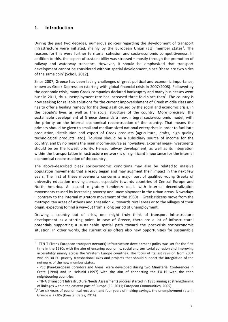
spatial development and the amelioration of the official transport policy, which has been implemented until now. However, it should be clarified that in recent decades the priority has been given to the investments concerning the road network on national and regional level as well, as at the city and community level. More precisely, the network of the regional busses (ΚΤΕΛ) has been remarkably extended and ameliorated. Nevertheless, the construction of the railway line from Neo Ikonio (freight port) to Thriasio Pedio (shunting yard) in 2013 should be mentioned (Figure 1.1). Namely, the line only serves freight traffic, and it links the port of Neo Ikonio to the rest of the rail network in Thriasio Pedio complex, where rail and freight operations are assembled. The rail link to Piraeus freight port at Neo Ikonio enable imported goods, mostly coming into Greece by sea through the port, to be channelled to their final destinations across the country by train. Similarly, it is possible to transport Greek goods by train to Piraeus port, either to be exported or to be delivered to the Aegean Sea islands, thus contributing to the development of combined freight transport. In the long term, taking into account trends showing a drastic increase in ships carrying containers and vehicles from the Far East, as well as the tendency to limit distribution points to only few ports in the Mediterranean, the rail link of Piraeus port (which is well placed to serve as such a point of distribution) may be extended beyond the northern borders of Greece. Therefore, this project will lead to a significant increase in rail traffic (reversing negative trends of recent years), largely due to the modal shift from road to rail, with all the advantages that this entails in terms of energy consumption, environmental management, accidents in the transport sector, etc. (http://ergose.gr). The fact that the construction of this freight railway line was financed by international investor (i.e. Chinese company COSCO) shows the importance of Greece as a transportation node of transnational importance.
Figure 1.1. Overview of transport network in the metropolitan area of Athens
(Source: ETH documentation)
On the other side, the investments (funded by the Greek government and the EU) in the Greek railway network during the last decade have not delivered the expected positive effect in national and regional level yet. Particularly inconvenient situation is in the Athens agglomeration, where three main spatial problems can be noticed.
5
Firstly, there is no direct and convenient rail connection between Athens airport and city centre. This means that passengers on the line Airport-‐Kiato have to transfer in SKA station. Trains along this new line run every hour and are electrified (standard gauge). One of the main reasons for a transfer is the diesel track operation in the branch between Athens centre and SKA station. In addition to this, transfer conditions in SKA are highly unfavourable (long walking distances and unreliable timetable). This will be particularly elaborated in following chapters.
Secondly, the port of Piraeus, 12 kilometers far from Athens city centre and with almost a 2500-‐year history and great archeological, strategic and commercial importance not only in Greece, but also in Europe, nowadays lacks efficient connection with the rest of Greece in terms of passenger transport. Namely, although the port city of Piraeus has a multilateral importance, there is a lack of its connection with railway network systems in order to enable reliable passenger transportation to the city of Athens and other main urban centres in Greece. More precisely, until 2004 a metric (Peloponnese) rail network was operating from the old (metric gauge) station Agios Ioannis in Piraeus, via Peloponnese station towards the entire Peloponnese peninsula (regard to Figure 2.7). Nowadays the metric line is suspended operating only the non-‐electrified line connecting Piraeus and main railways station in Athens (Larissis).
Finally, main railway station is recognized as a barrier in urban context of Athens. Although Larissis station is an important node along the SKA-‐Piraeus corridor, it should be particularly noticed that it also plays a crucial role in connecting western and eastern city areas. Namely, there is a lack of cohesion between eastern (i.e. developed) part of the city, which is also covered by the Athens Urban Integrated Plan and thus recognized as one of the most perspective urban areas for future development. On the other side, western part of the city has a dual character. Mainly, it is recognized as an underdeveloped area due to the Eleonas 900-‐hectare brownfield site, which is dominant in this zone. However, in the close vicinity of both Larissis station and Eleonas area is the Plato’s Academy, the place of great cultural and historical heritage. Thus, in such complex present conditions it is necessary to understand the multifaceted importance of Athens main railway station improvement and to look for various opportunities of its future development. This, in fact, will be a key research point during the seminar week, as it is stated in Chapter 4.
6
2. Overview
2.1. Railway development in Greece
2.1.1. Past railway development in Greece In the middle of the 19th century, the Prime Minister Charilaos Trikoupis managed to envision a very ambitious plan for the newly constituted Greek state: the development of the Greek railway network. In 1869, the first railway train travelled from Athens to Piraeus.
In 1831, after the official recognition of Greek independence from the Ottoman Empire, Thessaly, an administration region between Athens and Thessaloniki, was incorporated to Greece. The construction of the railway line from Athens to Larissa and Volos was important for political and military reasons. The railway line had to connect Greece to the rest of Europe, while at the same time it should facilitate army and ammunition supply to the Greek borders in a quick and cheap manner. Thessaloniki in Macedonia was freed only 80 years later.
An Italian engineer named Evaristo de Chirico played an important role in the construction of the railway line to Volos and to the mountain Pilion. His son, the famous Italian painter Giorgio de Chirico, who was born in 1888 in Volos, depicted the imposing stony railway bridge in Pilion designed by his father, in one of his metaphysical-‐surrealistic paintings.
The integration of Peloponnese to the railway network played an important economic role. Though Peloponnese is a mountainous territory, it also contains large, fertile high plateaus, as those existing for example, around the towns of Kalavryta and Tripolis, where intensive cereal cultivation takes place. In this way the interior of the Peloponnese seems to be the granary of Greece. However, due to a lack of road and railway infrastructure, inland grain transport was expensive. At that time, it was more expensive to transport grain from Kalavryta to Aigion (40 km away) than from Odessa (in Russia) to Aigion. For this reason, not just a single railway-‐line was constructed in Peloponnese region, but rather the railway network running along the coastline of the peninsula and crisscrossing the inland areas.
In 1886, the railway came to Navplion, 1887 to Patras, 1892 to Tripoli, and in 1899 to Kalamata. Technical and economic reasons have determined in the Peloponnese railway network a track width of 1.00 m (metric) instead of 1.435m (standard) (Figure 2.8). The construction costs of the metric gauge were much lower, especially in mountainous areas where tunnels, bridges and other engineering structures were needed. The network is today disconnected, with the exception of a few parts operating only for touristic purposes (for example between Diakofto and Kalavryta) and the tram-‐like operation in Patras (ETH, 2014).
The first trains in Greece belonged to private companies. The organization of these companies was satisfactory – detailed regulations defined each business activity with military discipline. This meant that thousands of people from different social classes, different cultures and different countries were working together harmoniously for many decades. Moreover, the development of the railroad resulted in the improvement of the postal and telegraph services (http://ose.gr).
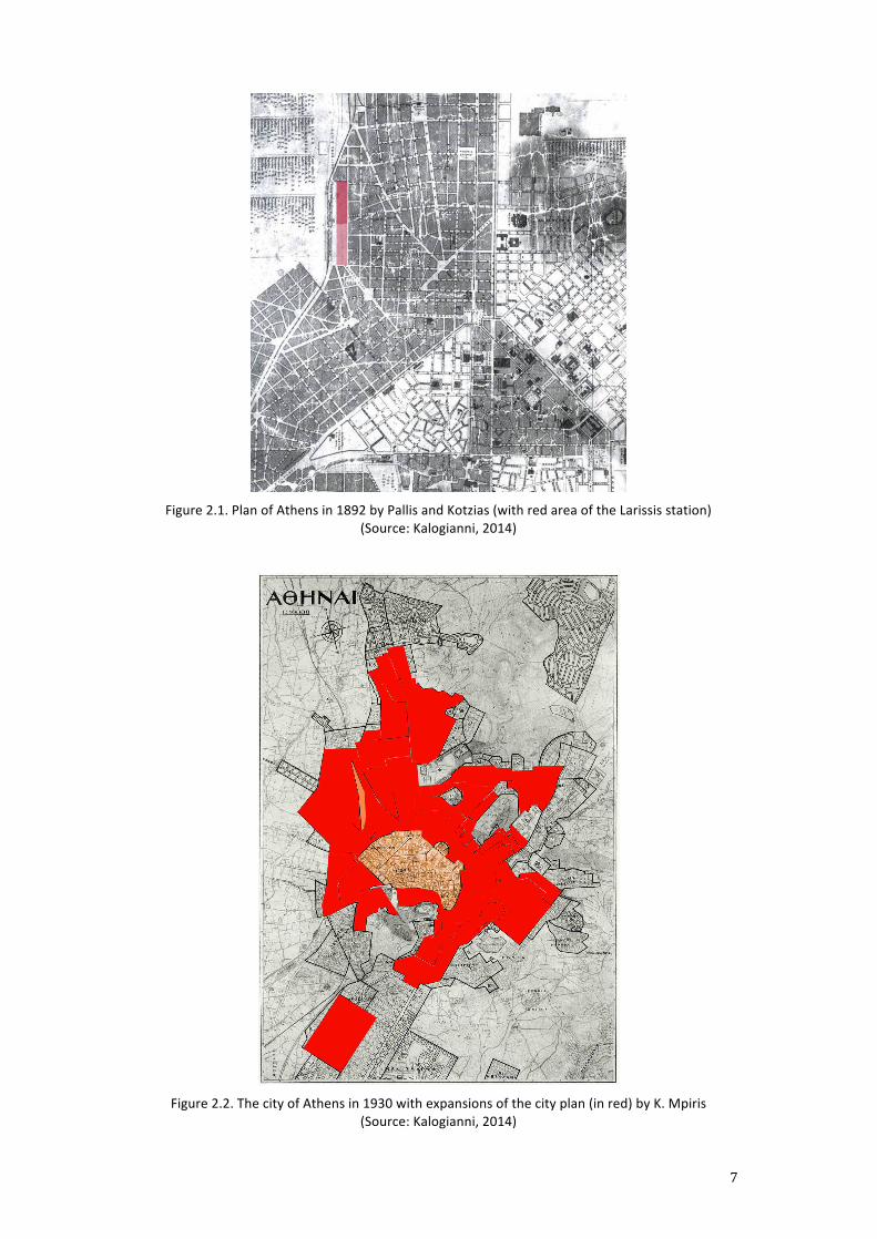
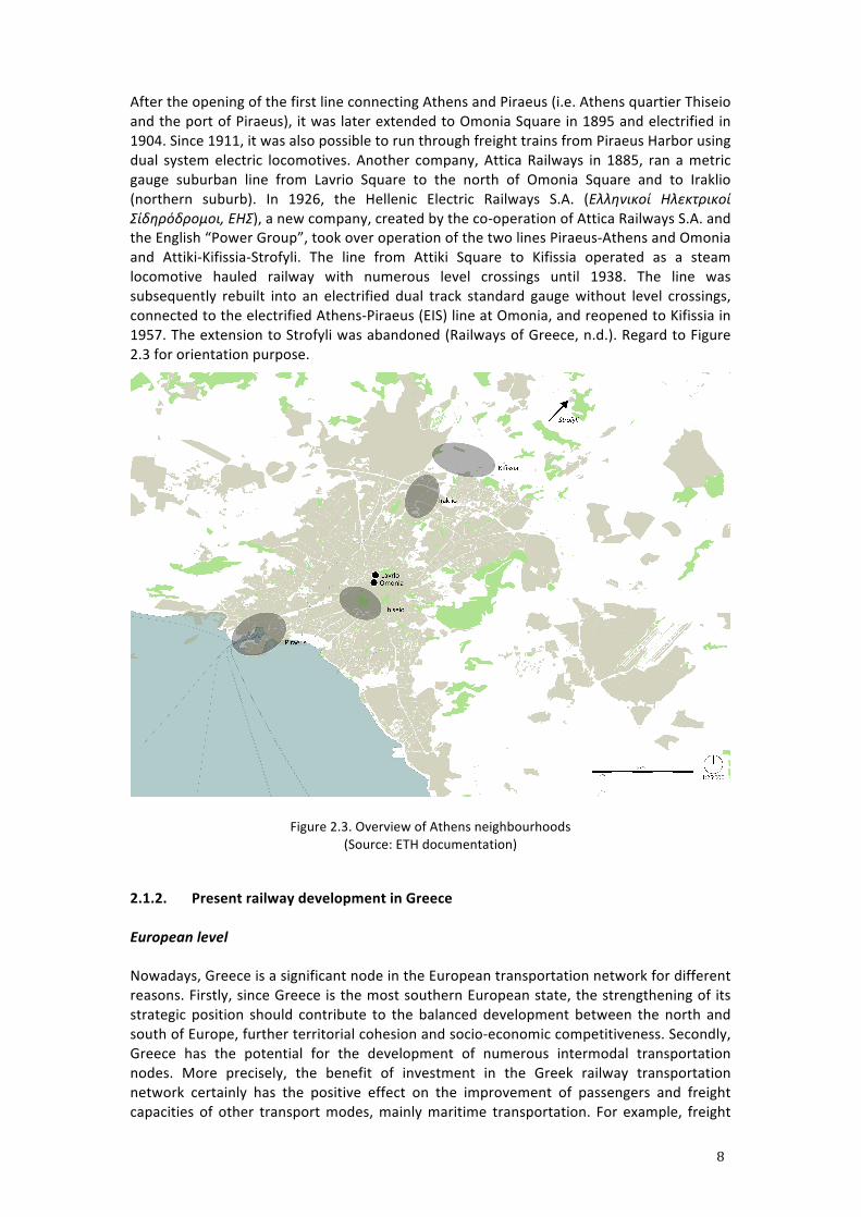
Urban railways of Athens agglomeration were developed at fast pace. The area of the railway station was for the first time incorporated into the City Plan in 1890. More precisely, within the City Plan of Athens from 1892, the Larissis station was included as a part of peripheral city area (Figure 2.1). Several decades later, in 1930, the Larissis station and its catchment area were considerably included into the major urban areas of the city of Athens (Figure 2.2).
7
Figure 2.1. Plan of Athens in 1892 by Pallis and Kotzias (with red area of the Larissis station)
(Source: Kalogianni, 2014)
Figure 2.2. The city of Athens in 1930 with expansions of the city plan (in red) by K. Mpiris
(Source: Kalogianni, 2014)
8
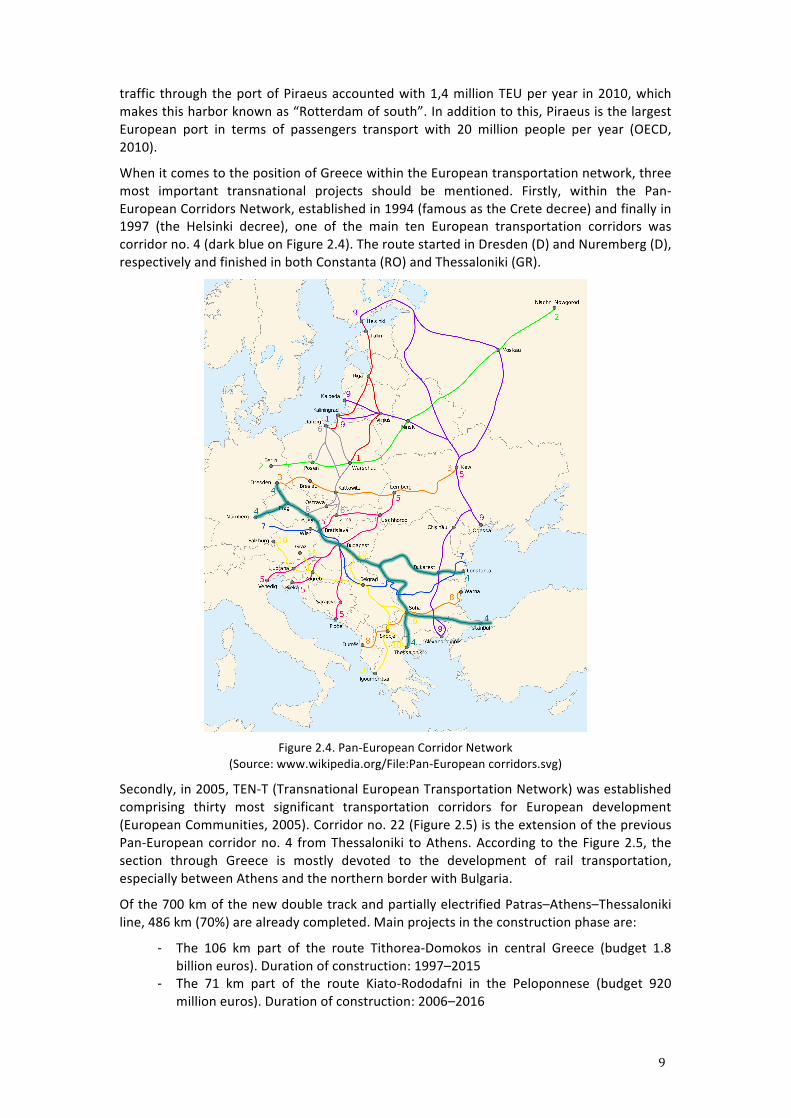
After the opening of the first line connecting Athens and Piraeus (i.e. Athens quartier Thiseio and the port of Piraeus), it was later extended to Omonia Square in 1895 and electrified in 1904. Since 1911, it was also possible to run through freight trains from Piraeus Harbor using dual system electric locomotives. Another company, Attica Railways in 1885, ran a metric gauge suburban line from Lavrio Square to the north of Omonia Square and to Iraklio (northern suburb). In 1926, the Hellenic Electric Railways S.A. (Ελληνικοί Ηλεκτρικοί Σίδηρόδρομοι, ΕΗΣ), a new company, created by the co-‐operation of Attica Railways S.A. and the English “Power Group”, took over operation of the two lines Piraeus-‐Athens and Omonia and Attiki-‐Kifissia-‐Strofyli. The line from Attiki Square to Kifissia operated as a steam locomotive hauled railway with numerous level crossings until 1938. The line was subsequently rebuilt into an electrified dual track standard gauge without level crossings, connected to the electrified Athens-‐Piraeus (EIS) line at Omonia, and reopened to Kifissia in 1957. The extension to Strofyli was abandoned (Railways of Greece, n.d.). Regard to Figure 2.3 for orientation purpose.
Figure 2.3. Overview of Athens neighbourhoods (Source: ETH documentation)
2.1.2. Present railway development in Greece
European level
Nowadays, Greece is a significant node in the European transportation network for different reasons. Firstly, since Greece is the most southern European state, the strengthening of its strategic position should contribute to the balanced development between the north and south of Europe, further territorial cohesion and socio-‐economic competitiveness. Secondly, Greece has the potential for the development of numerous intermodal transportation nodes. More precisely, the benefit of investment in the Greek railway transportation network certainly has the positive effect on the improvement of passengers and freight capacities of other transport modes, mainly maritime transportation. For example, freight
9
traffic through the port of Piraeus accounted with 1,4 million TEU per year in 2010, which makes this harbor known as “Rotterdam of south”. In addition to this, Piraeus is the largest European port in terms of passengers transport with 20 million people per year (OECD, 2010).
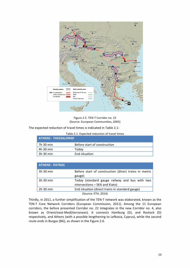
When it comes to the position of Greece within the European transportation network, three most important transnational projects should be mentioned. Firstly, within the Pan-‐European Corridors Network, established in 1994 (famous as the Crete decree) and finally in 1997 (the Helsinki decree), one of the main ten European transportation corridors was corridor no. 4 (dark blue on Figure 2.4). The route started in Dresden (D) and Nuremberg (D), respectively and finished in both Constanta (RO) and Thessaloniki (GR).
Figure 2.4. Pan-‐European Corridor Network
(Source: www.wikipedia.org/File:Pan-‐European corridors.svg)
Secondly, in 2005, TEN-‐T (Transnational European Transportation Network) was established comprising thirty most significant transportation corridors for European development (European Communities, 2005). Corridor no. 22 (Figure 2.5) is the extension of the previous Pan-‐European corridor no. 4 from Thessaloniki to Athens. According to the Figure 2.5, the section through Greece is mostly devoted to the development of rail transportation, especially between Athens and the northern border with Bulgaria.
Of the 700 km of the new double track and partially electrified Patras–Athens–Thessaloniki line, 486 km (70%) are already completed. Main projects in the construction phase are:
-‐ The 106 km part of the route Tithorea-‐Domokos in central Greece (budget 1.8 billion euros). Duration of construction: 1997–2015
-‐ The 71 km part of the route Kiato-‐Rododafni in the Peloponnese (budget 920 million euros). Duration of construction: 2006–2016
10
Figure 2.5. TEN-‐T Corridor no. 22
(Source: European Communities, 2005)
The expected reduction of travel times is indicated in Table 2.1:
Table 2.1. Expected reduction of travel times ATHENS -‐ THESSALONIKI
7h 30 min Before start of construction 4h 30 min Today 3h 30 min End situation
ATHENS -‐ PATRAS
3h 30 min Before start of construction (direct trains in metric gauge)
3h 30 min Today (standard gauge railway and bus with two intersections – SKA and Kiato)
2h 30 min End situation (direct trains in standard gauge) (Source: ETH, 2014)
Thirdly, in 2011, a further simplification of the TEN-‐T network was elaborated, known as the TEN-‐T Core Network Corridors (European Commission, 2011). Among the 11 European corridors, the before presented Corridor no. 22 integrates in the new Corridor no. 4, also known as Orient/east-‐Med(iterranean). It connects Hamburg (D), and Rostock (D) respectively, and Athens (with a possible lengthening to Lefkosia, Cyprus), while the second route ends in Burgas (BG), as shown in the Figure 2.6.
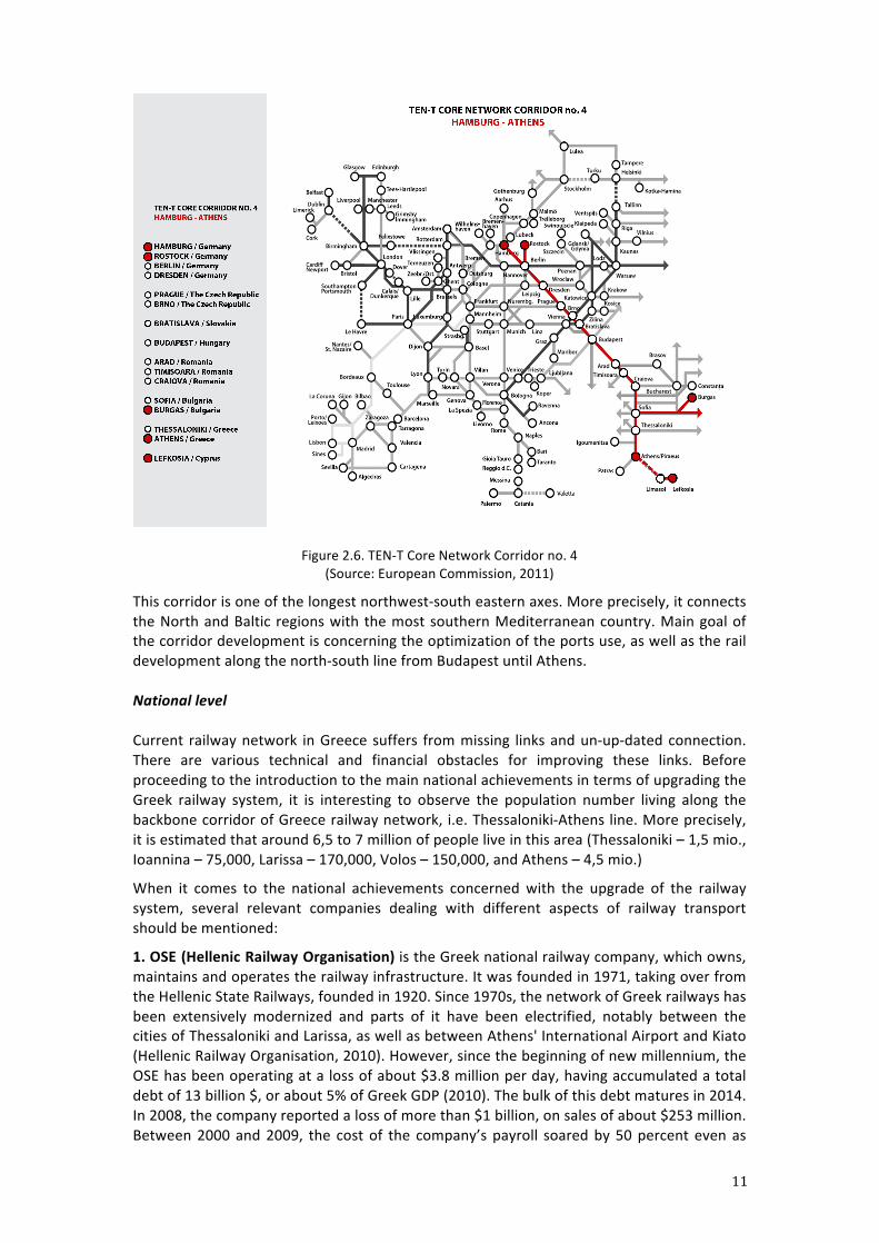
11
Figure 2.6. TEN-‐T Core Network Corridor no. 4 (Source: European Commission, 2011)
This corridor is one of the longest northwest-‐south eastern axes. More precisely, it connects the North and Baltic regions with the most southern Mediterranean country. Main goal of the corridor development is concerning the optimization of the ports use, as well as the rail development along the north-‐south line from Budapest until Athens. National level Current railway network in Greece suffers from missing links and un-‐up-‐dated connection. There are various technical and financial obstacles for improving these links. Before proceeding to the introduction to the main national achievements in terms of upgrading the Greek railway system, it is interesting to observe the population number living along the backbone corridor of Greece railway network, i.e. Thessaloniki-‐Athens line. More precisely, it is estimated that around 6,5 to 7 million of people live in this area (Thessaloniki – 1,5 mio., Ioannina – 75,000, Larissa – 170,000, Volos – 150,000, and Athens – 4,5 mio.)
When it comes to the national achievements concerned with the upgrade of the railway system, several relevant companies dealing with different aspects of railway transport should be mentioned:
1. OSE (Hellenic Railway Organisation) is the Greek national railway company, which owns, maintains and operates the railway infrastructure. It was founded in 1971, taking over from the Hellenic State Railways, founded in 1920. Since 1970s, the network of Greek railways has been extensively modernized and parts of it have been electrified, notably between the cities of Thessaloniki and Larissa, as well as between Athens' International Airport and Kiato (Hellenic Railway Organisation, 2010). However, since the beginning of new millennium, the OSE has been operating at a loss of about $3.8 million per day, having accumulated a total debt of 13 billion $, or about 5% of Greek GDP (2010). The bulk of this debt matures in 2014. In 2008, the company reported a loss of more than $1 billion, on sales of about $253 million. Between 2000 and 2009, the cost of the company’s payroll soared by 50 percent even as
12
overall personnel decreased by 30 percent (Railways of Greece, n.d.).
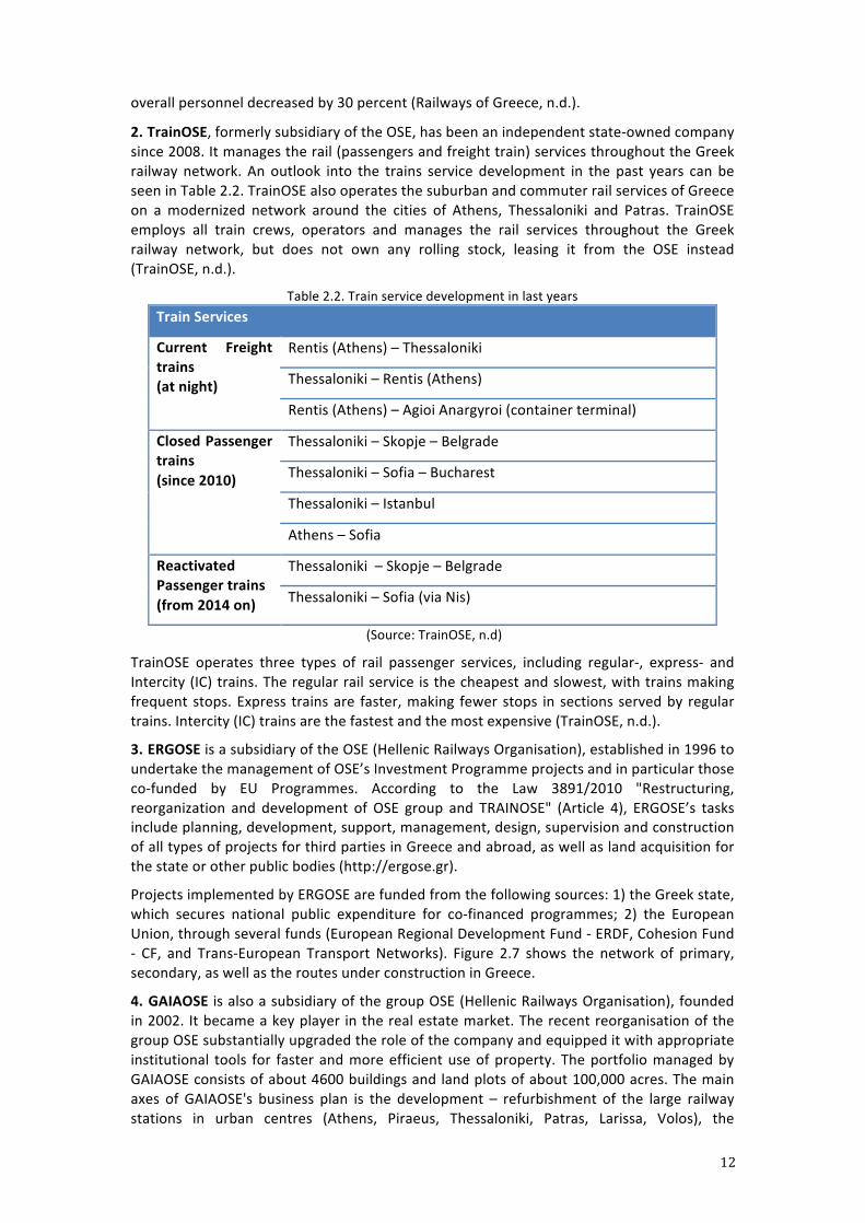
2. TrainOSE, formerly subsidiary of the OSE, has been an independent state-‐owned company since 2008. It manages the rail (passengers and freight train) services throughout the Greek railway network. An outlook into the trains service development in the past years can be seen in Table 2.2. TrainOSE also operates the suburban and commuter rail services of Greece on a modernized network around the cities of Athens, Thessaloniki and Patras. TrainOSE employs all train crews, operators and manages the rail services throughout the Greek railway network, but does not own any rolling stock, leasing it from the OSE instead (TrainOSE, n.d.).
Table 2.2. Train service development in last years Train Services
Current Freight trains (at night)
Rentis (Athens) – Thessaloniki
Thessaloniki – Rentis (Athens)
Rentis (Athens) – Agioi Anargyroi (container terminal)
Closed Passenger trains (since 2010)
Thessaloniki – Skopje – Belgrade
Thessaloniki – Sofia – Bucharest
Thessaloniki – Istanbul
Athens – Sofia
Reactivated Passenger trains (from 2014 on)
Thessaloniki – Skopje – Belgrade
Thessaloniki – Sofia (via Nis)
(Source: TrainOSE, n.d)
TrainOSE operates three types of rail passenger services, including regular-‐, express-‐ and Intercity (IC) trains. The regular rail service is the cheapest and slowest, with trains making frequent stops. Express trains are faster, making fewer stops in sections served by regular trains. Intercity (IC) trains are the fastest and the most expensive (TrainOSE, n.d.).
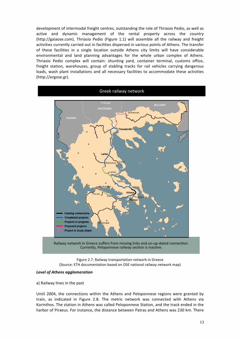
3. ERGOSE is a subsidiary of the OSE (Hellenic Railways Organisation), established in 1996 to undertake the management of OSE’s Investment Programme projects and in particular those co-‐funded by EU Programmes. According to the Law 3891/2010 "Restructuring, reorganization and development of OSE group and TRAINOSE" (Article 4), ERGOSE’s tasks include planning, development, support, management, design, supervision and construction of all types of projects for third parties in Greece and abroad, as well as land acquisition for the state or other public bodies (http://ergose.gr).
Projects implemented by ERGOSE are funded from the following sources: 1) the Greek state, which secures national public expenditure for co-‐financed programmes; 2) the European Union, through several funds (European Regional Development Fund -‐ ERDF, Cohesion Fund -‐ CF, and Trans-‐European Transport Networks). Figure 2.7 shows the network of primary, secondary, as well as the routes under construction in Greece.
4. GAIAOSE is also a subsidiary of the group OSE (Hellenic Railways Organisation), founded in 2002. It became a key player in the real estate market. The recent reorganisation of the group OSE substantially upgraded the role of the company and equipped it with appropriate institutional tools for faster and more efficient use of property. The portfolio managed by GAIAOSE consists of about 4600 buildings and land plots of about 100,000 acres. The main axes of GAIAOSE's business plan is the development – refurbishment of the large railway stations in urban centres (Athens, Piraeus, Thessaloniki, Patras, Larissa, Volos), the
13
development of intermodal freight centres, outstanding the role of Thriasio Pedio, as well as active and dynamic management of the rental property across the country (http://gaiaose.com). Thriasio Pedio (Figure 1.1) will assemble all the railway and freight activities currently carried out in facilities dispersed in various points of Athens. The transfer of these facilities in a single location outside Athens city limits will have considerable environmental and land planning advantages for the whole urban complex of Athens. Thriasio Pedio complex will contain: shunting yard, container terminal, customs office, freight station, warehouses, group of stabling tracks for rail vehicles carrying dangerous loads, wash plant installations and all necessary facilities to accommodate these activities (http://ergose.gr).
Figure 2.7. Railway transportation network in Greece
(Source: ETH documentation based on OSE national railway network map)
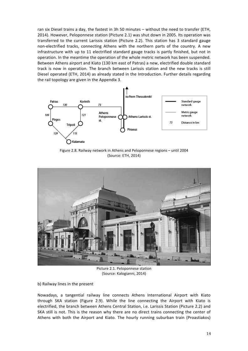
Level of Athens agglomeration a) Railway lines in the past Until 2004, the connections within the Athens and Peloponnese regions were granted by train, as indicated in Figure 2.8. The metric network was connected with Athens via Korinthos. The station in Athens was called Peloponnese Station, and the track ended in the harbor of Piraeus. For instance, the distance between Patras and Athens was 230 km. There
Greek railway network
Railway network in Greece suffers from missing links and un-‐up-‐dated connecron. Currently, Peloponnese railway secron is inacrve.
Completed projectsProjects in progressProposed projectsProject in study phase
Existing connections
FYROM
14
ran six Diesel trains a day, the fastest in 3h 50 minutes – without the need to transfer (ETH, 2014). However, Peloponnese station (Picture 2.1) was shut down in 2005. Its operation was transferred to the current Larissis station (Picture 2.2). This station has 3 standard gauge non-‐electrified tracks, connecting Athens with the northern parts of the country. A new infrastructure with up to 11 electrified standard gauge tracks is partly finished, but not in operation. In the meantime the operation of the whole metric network has been suspended. Between Athens airport and Kiato (130 km east of Patras) a new, electrified double standard track is now in operation. The branch between Larissis station and the new tracks is still Diesel operated (ETH, 2014) as already stated in the Introduction. Further details regarding the rail topology are given in the Appendix 3.
Figure 2.8. Railway network in Athens and Peloponnese regions – until 2004
(Source: ETH, 2014)
Picture 2.1. Peloponnese station (Source: Kalogianni, 2014)
b) Railway lines in the present Nowadays, a tangential railway line connects Athens International Airport with Kiato through SKA station (Figure 2.9). While the line connecting the Airport with Kiato is electrified, the branch between Athens Central Station, i.e. Larissis Station (Picture 2.2) and SKA still is not. This is the reason why there are no direct trains connecting the center of Athens with both the Airport and Kiato. The hourly running suburban train (Proastiakos)
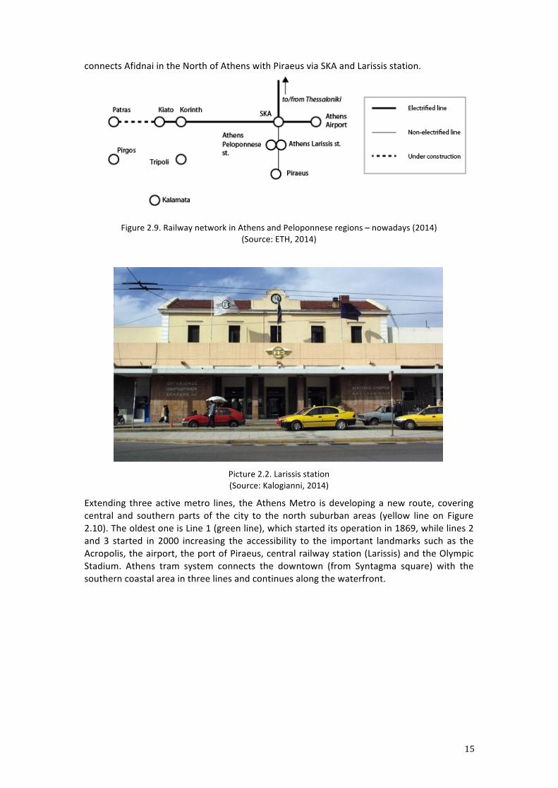
15
connects Afidnai in the North of Athens with Piraeus via SKA and Larissis station.
Figure 2.9. Railway network in Athens and Peloponnese regions – nowadays (2014) (Source: ETH, 2014)
Picture 2.2. Larissis station (Source: Kalogianni, 2014)
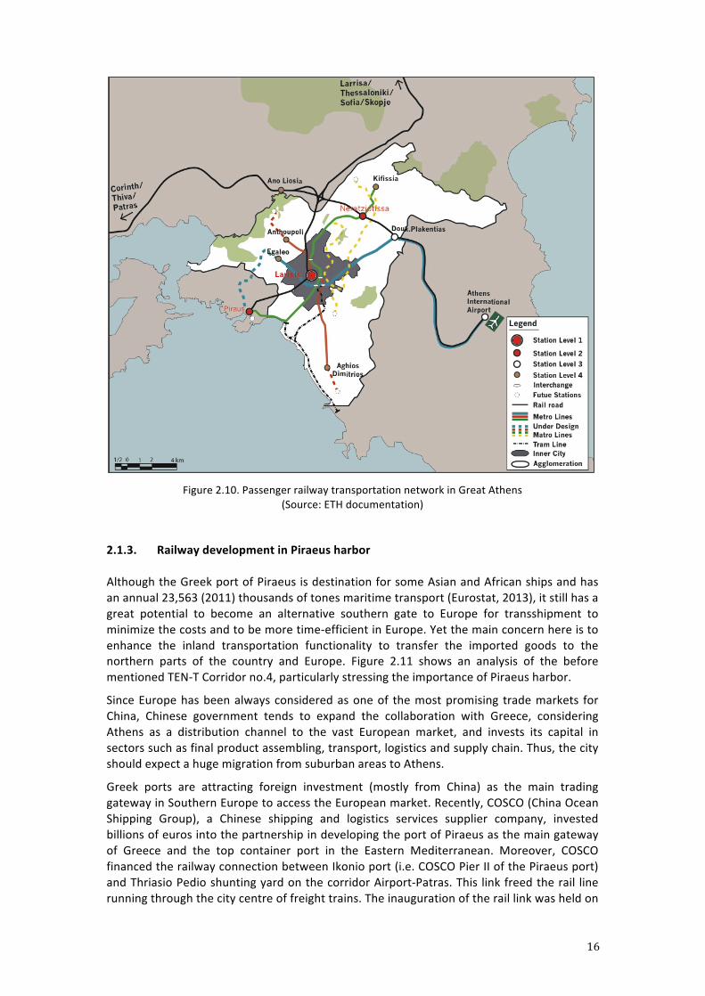
Extending three active metro lines, the Athens Metro is developing a new route, covering central and southern parts of the city to the north suburban areas (yellow line on Figure 2.10). The oldest one is Line 1 (green line), which started its operation in 1869, while lines 2 and 3 started in 2000 increasing the accessibility to the important landmarks such as the Acropolis, the airport, the port of Piraeus, central railway station (Larissis) and the Olympic Stadium. Athens tram system connects the downtown (from Syntagma square) with the southern coastal area in three lines and continues along the waterfront.
16
Figure 2.10. Passenger railway transportation network in Great Athens
(Source: ETH documentation)
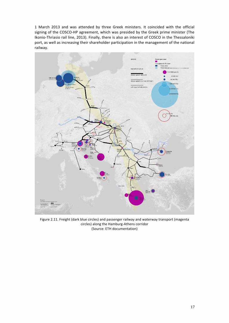
2.1.3. Railway development in Piraeus harbor Although the Greek port of Piraeus is destination for some Asian and African ships and has an annual 23,563 (2011) thousands of tones maritime transport (Eurostat, 2013), it still has a great potential to become an alternative southern gate to Europe for transshipment to minimize the costs and to be more time-‐efficient in Europe. Yet the main concern here is to enhance the inland transportation functionality to transfer the imported goods to the northern parts of the country and Europe. Figure 2.11 shows an analysis of the before mentioned TEN-‐T Corridor no.4, particularly stressing the importance of Piraeus harbor.
Since Europe has been always considered as one of the most promising trade markets for China, Chinese government tends to expand the collaboration with Greece, considering Athens as a distribution channel to the vast European market, and invests its capital in sectors such as final product assembling, transport, logistics and supply chain. Thus, the city should expect a huge migration from suburban areas to Athens.
Greek ports are attracting foreign investment (mostly from China) as the main trading gateway in Southern Europe to access the European market. Recently, COSCO (China Ocean Shipping Group), a Chinese shipping and logistics services supplier company, invested billions of euros into the partnership in developing the port of Piraeus as the main gateway of Greece and the top container port in the Eastern Mediterranean. Moreover, COSCO financed the railway connection between Ikonio port (i.e. COSCO Pier II of the Piraeus port) and Thriasio Pedio shunting yard on the corridor Airport-‐Patras. This link freed the rail line running through the city centre of freight trains. The inauguration of the rail link was held on
17
1 March 2013 and was attended by three Greek ministers. It coincided with the official signing of the COSCO-‐HP agreement, which was presided by the Greek prime minister (The Ikonio-‐Thriasio rail line, 2013). Finally, there is also an interest of COSCO in the Thessaloniki port, as well as increasing their shareholder participation in the management of the national railway.
Figure 2.11. Freight (dark blue circles) and passenger railway and waterway transport (magenta circles) along the Hamburg-‐Athens corridor
(Source: ETH documentation)
18
2.2. Urban Development in Athens
2.2.1. History of Athens urban development
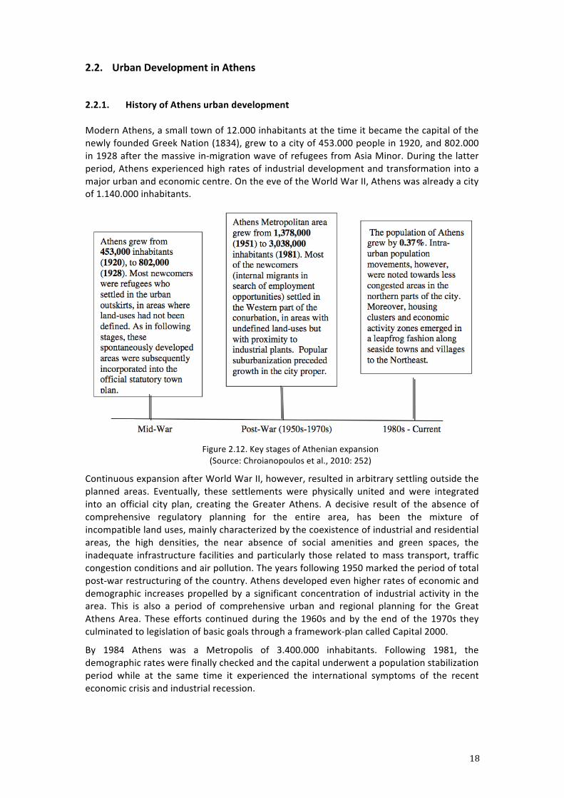
Modern Athens, a small town of 12.000 inhabitants at the time it became the capital of the newly founded Greek Nation (1834), grew to a city of 453.000 people in 1920, and 802.000 in 1928 after the massive in-‐migration wave of refugees from Asia Minor. During the latter period, Athens experienced high rates of industrial development and transformation into a major urban and economic centre. On the eve of the World War II, Athens was already a city of 1.140.000 inhabitants.
Figure 2.12. Key stages of Athenian expansion (Source: Chroianopoulos et al., 2010: 252)
Continuous expansion after World War II, however, resulted in arbitrary settling outside the planned areas. Eventually, these settlements were physically united and were integrated into an official city plan, creating the Greater Athens. A decisive result of the absence of comprehensive regulatory planning for the entire area, has been the mixture of incompatible land uses, mainly characterized by the coexistence of industrial and residential areas, the high densities, the near absence of social amenities and green spaces, the inadequate infrastructure facilities and particularly those related to mass transport, traffic congestion conditions and air pollution. The years following 1950 marked the period of total post-‐war restructuring of the country. Athens developed even higher rates of economic and demographic increases propelled by a significant concentration of industrial activity in the area. This is also a period of comprehensive urban and regional planning for the Great Athens Area. These efforts continued during the 1960s and by the end of the 1970s they culminated to legislation of basic goals through a framework-‐plan called Capital 2000.
By 1984 Athens was a Metropolis of 3.400.000 inhabitants. Following 1981, the demographic rates were finally checked and the capital underwent a population stabilization period while at the same time it experienced the international symptoms of the recent economic crisis and industrial recession.
19
Finally, Athens is an example of the Mediterranean city3. Its crucial characteristic in Athens case is the unplanned mode of the city expansion. Three main phases of expansion throughout the last century are shown in the Figure 2.12. 2.2.2. Current conditions of Athens urban development
Socio-‐spatial structure Since the mid-‐1970s, the dominant process of urban growth in Athens has been middle-‐class suburbanization. This process has reinforced community segregation and, at the same time, has triggered a filtering-‐down process in wide areas around the CBD, formerly occupied by upper and mainly intermediate professional categories. Interclass vertical segregation has subsequently appeared in these areas, where intermediate professional categories and lower middle-‐class households are now predominant. The fact that these areas do not represent a real choice for any of their resident groups shows that this vertical cohabitation has been the unintended consequence of changing segregation patterns, and hardly the outcome or the corollary of a growing process of socio-‐spatial homogenization (Maloutas, 2003).
Middle-‐class population is the most affected by the recent economic crisis. Indeed, the lack of crisis management during this time caused a great rearrangement in social and economic classification accordingly drove a variety of social classes to the extremes of the social ladder. In a sense, the process of industrial relocation and urban renovation has deeply affected the whole structure of urban populations and the morphology of urban landscapes. The current distribution of uses along the axis of Panepistimou, a street connecting Syntagma-‐ with Omonia square, is characterized by a high proportion of office and administration use, as well as some retail activity. As a consequence, an unbalanced activity during day-‐ and nighttime occurs in the area.
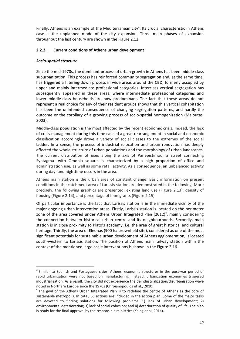
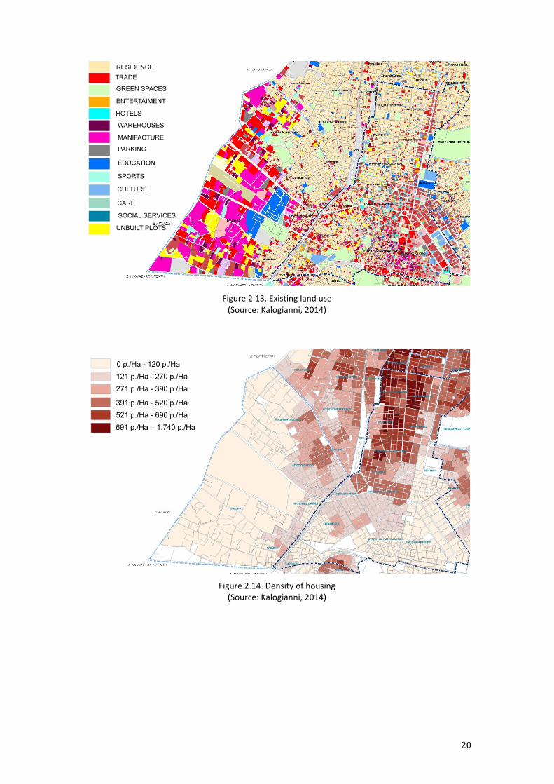
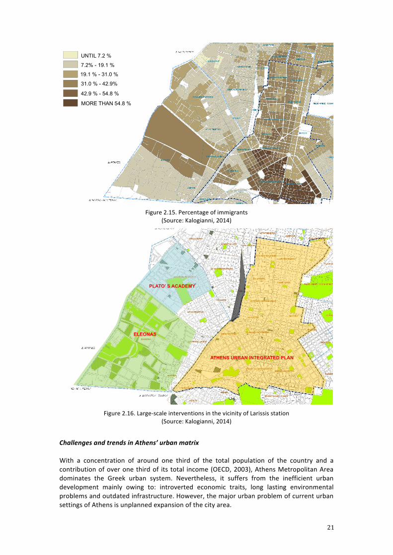
Athens main station is the urban area of constant change. Basic information on present conditions in the catchment area of Larissis station are demonstrated in the following. More precisely, the following graphics are presented: existing land use (Figure 2.13), density of housing (Figure 2.14), and percentage of immigrants (Figure 2.15).
Of particular importance is the fact that Larissis station is in the immediate vicinity of the major ongoing urban intervention areas. Firstly, Larissis station is located on the perimeter zone of the area covered under Athens Urban Integrated Plan (2012)4, mainly considering the connection between historical urban centre and its neighbourhoods. Secondly, main station is in close proximity to Plato’s academy, i.e. the area of great historical and cultural heritage. Thirdly, the area of Eleonas (900 ha brownfield site), considered as one of the most significant potentials for sustainable urban development of Athens agglomeration, is located south-‐western to Larissis station. The position of Athens main railway station within the context of the mentioned large-‐scale interventions is shown in the Figure 2.16.
3 Similar to Spanish and Portuguese cities, Athens’ economic structures in the post-‐war period of rapid urbanization were not based on manufacturing. Instead, urbanization economies triggered industrialization. As a result, the city did not experience the deindustrialization/disurbanisation wave noted in Northern Europe since the 1970s (Chroianopoulos et al., 2010). 4 The goal of the Athens Urban Integrated Plan is to redefine the centre of Athens as the core of sustainable metropolis. In total, 65 actions are included in the action plan. Some of the major tasks are devoted to finding solutions for following problems: 1) lack of urban development; 2) environmental deterioration; 3) lack of social cohesion; and 4) deterioration of quality of life. The plan is ready for the final approval by the responsible ministries (Kalogianni, 2014).
20
Figure 2.13. Existing land use (Source: Kalogianni, 2014)
Figure 2.14. Density of housing (Source: Kalogianni, 2014)
TRADE
GREEN SPACES
SPORTS
UNBUILT PLOTS
CULTURE
CARE
SOCIAL SERVICES
ENTERTAIMENT
HOTELS
WAREHOUSES
PARKING
EDUCATION
RESIDENCE
MANIFACTURE
121 p./Ha - 270 p./Ha 0 p./Ha - 120 p./Ha
271 p./Ha - 390 p./Ha
391 p./Ha - 520 p./Ha
691 p./Ha – 1.740 p./Ha 521 p./Ha - 690 p./Ha
21
Figure 2.15. Percentage of immigrants
(Source: Kalogianni, 2014)
Figure 2.16. Large-‐scale interventions in the vicinity of Larissis station
(Source: Kalogianni, 2014)
Challenges and trends in Athens’ urban matrix With a concentration of around one third of the total population of the country and a contribution of over one third of its total income (OECD, 2003), Athens Metropolitan Area dominates the Greek urban system. Nevertheless, it suffers from the inefficient urban development mainly owing to: introverted economic traits, long lasting environmental problems and outdated infrastructure. However, the major urban problem of current urban settings of Athens is unplanned expansion of the city area.
UNTIL 7.2 %
MORE THAN 54.8 %
7.2% - 19.1 %
31.0 % - 42.9%
19.1 % - 31.0 %
42.9 % - 54.8 %
ATHENS URBAN INTEGRATED PLAN
ELEONAS
PLATO’ S ACADEMY
22
These spontaneous urbanization processes driven by self-‐promoted housing strategies are imprinted on the physical and functional facets of the Athenian urban environment, characterized by:
-‐ A combination of high densities in the urban core and sub-‐optimal land-‐use in the metropolitan periphery;
-‐ A high degree of land-‐use mix and lack of open public spaces in central areas; -‐ A low quality of environmental infrastructure and concomitant private car
transportation dependence; -‐ Significant distortion of the historical and natural topography (Leontidou et al.,
2007).
However, it should be noted that some efforts in raising Athens’ competitiveness were made during past decade owing to the Olympic Games, which were held in Athens in 2004. One of two priority project categories aimed at reducing peripheral development and improving the functional aspects of the metropolitan area, focusing on telecommunication and transport infrastructure provision. Key examples include the new Athens Underground, the international airport, the Athens ring road, the suburban railway and the tramway connecting the city centre with the western waterfront (Beriatos & Gospodini, 2004). This resulted in the following:
-‐ Establishment of new connections between previously ill-‐linked areas; -‐ Expansion of the functional urban limits; -‐ Transformation of the geography of the metropolis.
Nevertheless, the Athens metropolitan area still needs constant spatial improvement in order to become truly competitive European city. Further spatial strengthening of the Attica region can be achieved just through prospective investment in transport infrastructure. In addition, the city tends to develop towards the International Airport to the eastern part. Since some of the international railway connections to Greece have been suspended as seen previously in Table 2.2, the Athens International Airport has become an important alternative, covering the long-‐distance and international travels. Currently the airport hosts around 20 million passengers per year and is the main option to support the international tourism to Athens area and the southern islands. Public spaces in Athens
Unlike in other European cities, railway stations have a small functionality as the urban hubs and, in some cases the stations are situated even on the margins of the cities (e.g. Larissis station). However, the city of Athens has some other urban places as the main activity hubs of the city; mainly including the three urban squares: Syntagma, Omonia and Monastiraki (Picture 2.3). Other open spaces emerge in the city centre as focal points in the social activity of Athenians, including Plato’s Academy and other cultural and archeological sights shown in the Figure 2.17.
23
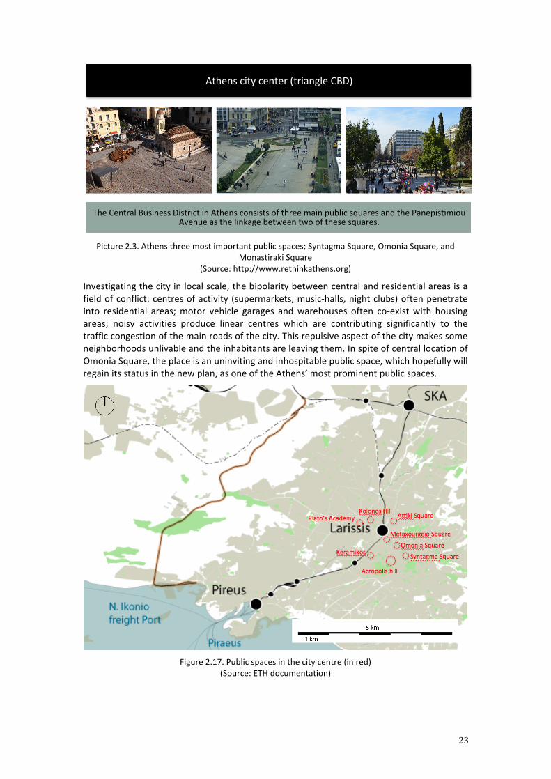
Picture 2.3. Athens three most important public spaces; Syntagma Square, Omonia Square, and
Monastiraki Square (Source: http://www.rethinkathens.org)
Investigating the city in local scale, the bipolarity between central and residential areas is a field of conflict: centres of activity (supermarkets, music-‐halls, night clubs) often penetrate into residential areas; motor vehicle garages and warehouses often co-‐exist with housing areas; noisy activities produce linear centres which are contributing significantly to the traffic congestion of the main roads of the city. This repulsive aspect of the city makes some neighborhoods unlivable and the inhabitants are leaving them. In spite of central location of Omonia Square, the place is an uninviting and inhospitable public space, which hopefully will regain its status in the new plan, as one of the Athens’ most prominent public spaces.
Figure 2.17. Public spaces in the city centre (in red)
(Source: ETH documentation)
Athens city center (triangle CBD)
The Central Business District in Athens consists of three main public squares and the Panepisrmiou Avenue as the linkage between two of these squares.
24
3. Problematics
3.1. Integrated spatial and railway development: SKA-‐Piraeus line
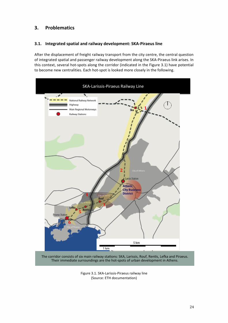
After the displacement of freight railway transport from the city centre, the central question of integrated spatial and passenger railway development along the SKA-‐Piraeus link arises. In this context, several hot-‐spots along the corridor (indicated in the Figure 3.1) have potential to become new centralities. Each hot-‐spot is looked more closely in the following.
Figure 3.1. SKA-‐Larissis-‐Piraeus railway line
(Source: ETH documentation)
SKA-‐Larissis-‐Piraeus Railway Line
The corridor consists of six main railway starons: SKA, Larissis, Rouf, Renrs, Leta and Piraeus. Their immediate surroundings are the hot-‐spots of urban development in Athens.
1
2
3
4
5
6
25
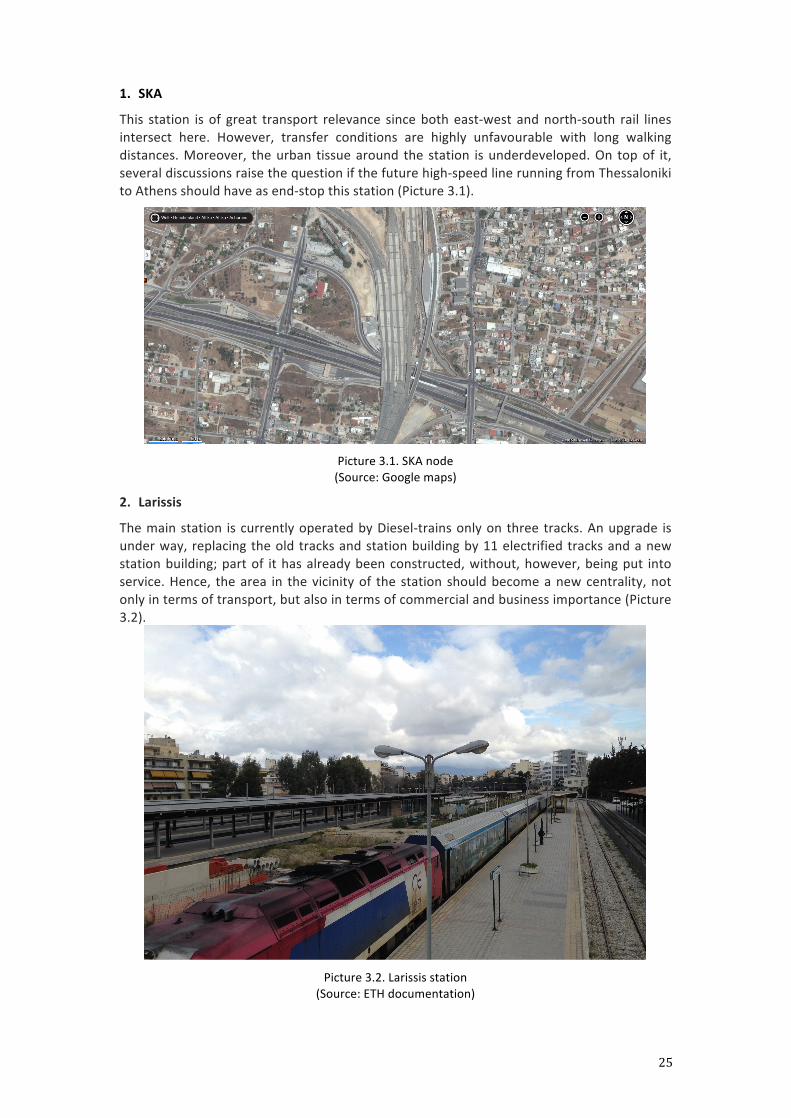
1. SKA
This station is of great transport relevance since both east-‐west and north-‐south rail lines intersect here. However, transfer conditions are highly unfavourable with long walking distances. Moreover, the urban tissue around the station is underdeveloped. On top of it, several discussions raise the question if the future high-‐speed line running from Thessaloniki to Athens should have as end-‐stop this station (Picture 3.1).
Picture 3.1. SKA node (Source: Google maps)
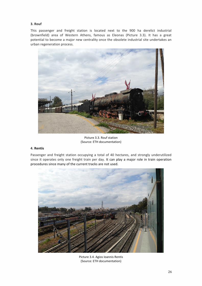
2. Larissis
The main station is currently operated by Diesel-‐trains only on three tracks. An upgrade is under way, replacing the old tracks and station building by 11 electrified tracks and a new station building; part of it has already been constructed, without, however, being put into service. Hence, the area in the vicinity of the station should become a new centrality, not only in terms of transport, but also in terms of commercial and business importance (Picture 3.2).
Picture 3.2. Larissis station
(Source: ETH documentation)
26
3. Rouf
This passenger and freight station is located next to the 900 ha derelict industrial (brownfield) area of Western Athens, famous as Eleonas (Picture 3.3). It has a great potential to become a major new centrality once the obsolete industrial site undertakes an urban regeneration process.
Picture 3.3. Rouf station
(Source: ETH documentation)
4. Rentis
Passenger and freight station occupying a total of 40 hectares, and strongly underutilized since it operates only one freight train per day. It can play a major role in train operation procedures since many of the current tracks are not used.
Picture 3.4. Agios Ioannis Rentis (Source: ETH documentation)
27
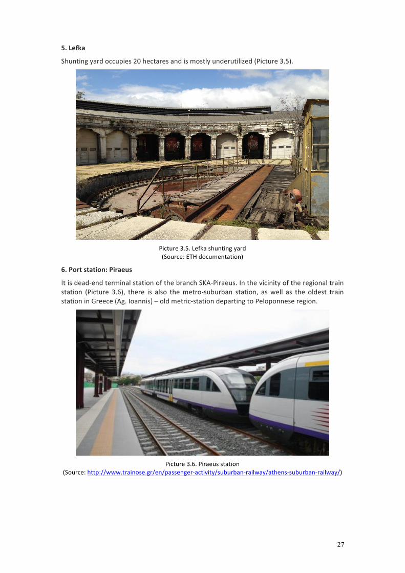
5. Lefka
Shunting yard occupies 20 hectares and is mostly underutilized (Picture 3.5).
Picture 3.5. Lefka shunting yard (Source: ETH documentation)
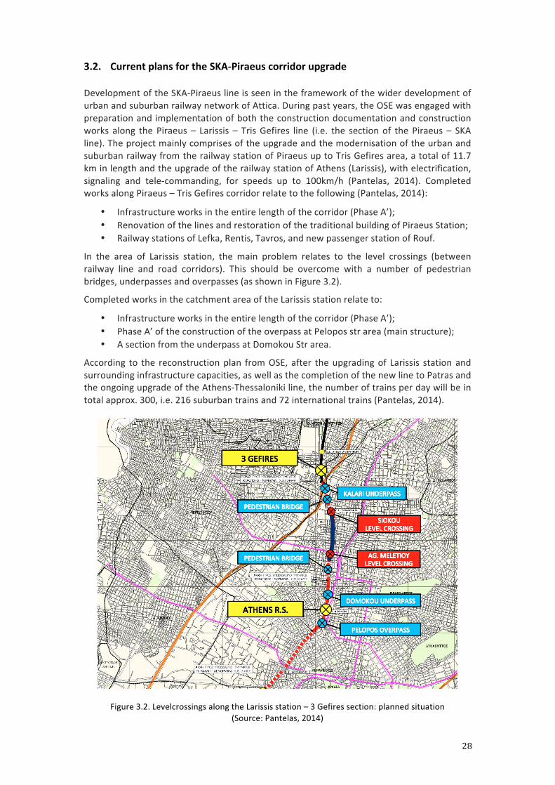
6. Port station: Piraeus
It is dead-‐end terminal station of the branch SKA-‐Piraeus. In the vicinity of the regional train station (Picture 3.6), there is also the metro-‐suburban station, as well as the oldest train station in Greece (Ag. Ioannis) – old metric-‐station departing to Peloponnese region.
Picture 3.6. Piraeus station
(Source: http://www.trainose.gr/en/passenger-‐activity/suburban-‐railway/athens-‐suburban-‐railway/)
28
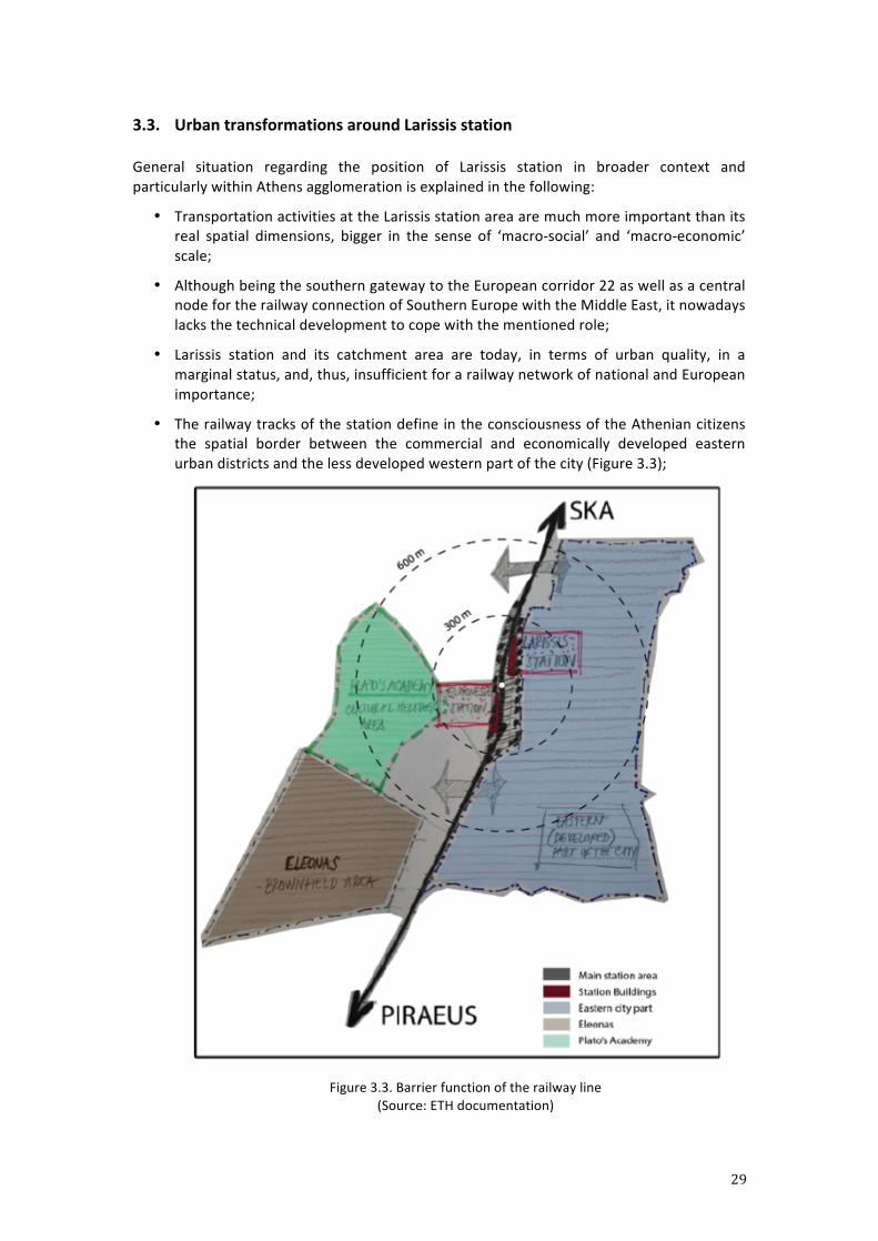
3.2. Current plans for the SKA-‐Piraeus corridor upgrade
Development of the SKA-‐Piraeus line is seen in the framework of the wider development of urban and suburban railway network of Attica. During past years, the OSE was engaged with preparation and implementation of both the construction documentation and construction works along the Piraeus – Larissis – Tris Gefires line (i.e. the section of the Piraeus – SKA line). The project mainly comprises of the upgrade and the modernisation of the urban and suburban railway from the railway station of Piraeus up to Tris Gefires area, a total of 11.7 km in length and the upgrade of the railway station of Athens (Larissis), with electrification, signaling and tele-‐commanding, for speeds up to 100km/h (Pantelas, 2014). Completed works along Piraeus – Tris Gefires corridor relate to the following (Pantelas, 2014):
• Infrastructure works in the entire length of the corridor (Phase A’); • Renovation of the lines and restoration of the traditional building of Piraeus Station; • Railway stations of Lefka, Rentis, Tavros, and new passenger station of Rouf.
In the area of Larissis station, the main problem relates to the level crossings (between railway line and road corridors). This should be overcome with a number of pedestrian bridges, underpasses and overpasses (as shown in Figure 3.2).
Completed works in the catchment area of the Larissis station relate to:
• Infrastructure works in the entire length of the corridor (Phase A’); • Phase A’ of the construction of the overpass at Pelopos str area (main structure); • A section from the underpass at Domokou Str area.
According to the reconstruction plan from OSE, after the upgrading of Larissis station and surrounding infrastructure capacities, as well as the completion of the new line to Patras and the ongoing upgrade of the Athens-‐Thessaloniki line, the number of trains per day will be in total approx. 300, i.e. 216 suburban trains and 72 international trains (Pantelas, 2014).
Figure 3.2. Levelcrossings along the Larissis station – 3 Gefires section: planned situation (Source: Pantelas, 2014)
29
3.3. Urban transformations around Larissis station
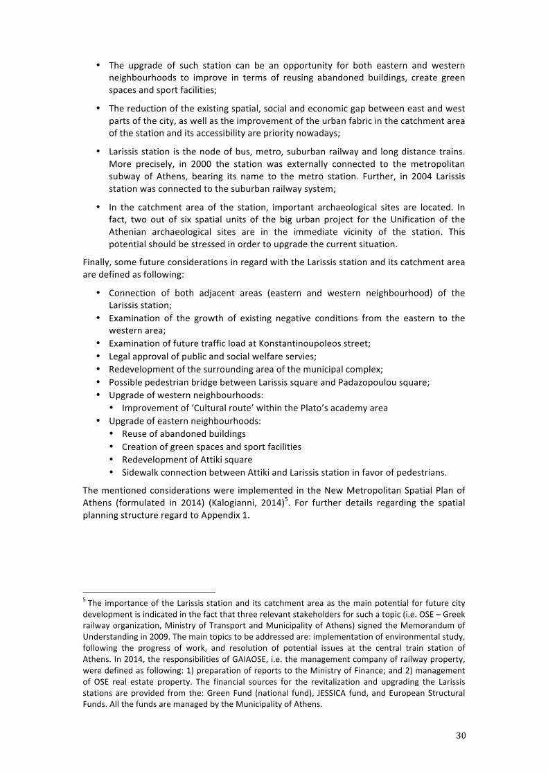
General situation regarding the position of Larissis station in broader context and particularly within Athens agglomeration is explained in the following:
• Transportation activities at the Larissis station area are much more important than its real spatial dimensions, bigger in the sense of ‘macro-‐social’ and ‘macro-‐economic’ scale;
• Although being the southern gateway to the European corridor 22 as well as a central node for the railway connection of Southern Europe with the Middle East, it nowadays lacks the technical development to cope with the mentioned role;
• Larissis station and its catchment area are today, in terms of urban quality, in a marginal status, and, thus, insufficient for a railway network of national and European importance;
• The railway tracks of the station define in the consciousness of the Athenian citizens the spatial border between the commercial and economically developed eastern urban districts and the less developed western part of the city (Figure 3.3);
Figure 3.3. Barrier function of the railway line
(Source: ETH documentation)
30
• The upgrade of such station can be an opportunity for both eastern and western neighbourhoods to improve in terms of reusing abandoned buildings, create green spaces and sport facilities;
• The reduction of the existing spatial, social and economic gap between east and west parts of the city, as well as the improvement of the urban fabric in the catchment area of the station and its accessibility are priority nowadays;
• Larissis station is the node of bus, metro, suburban railway and long distance trains. More precisely, in 2000 the station was externally connected to the metropolitan subway of Athens, bearing its name to the metro station. Further, in 2004 Larissis station was connected to the suburban railway system;
• In the catchment area of the station, important archaeological sites are located. In fact, two out of six spatial units of the big urban project for the Unification of the Athenian archaeological sites are in the immediate vicinity of the station. This potential should be stressed in order to upgrade the current situation.
Finally, some future considerations in regard with the Larissis station and its catchment area are defined as following:
• Connection of both adjacent areas (eastern and western neighbourhood) of the Larissis station;
• Examination of the growth of existing negative conditions from the eastern to the western area;
• Examination of future traffic load at Konstantinoupoleos street; • Legal approval of public and social welfare servies; • Redevelopment of the surrounding area of the municipal complex; • Possible pedestrian bridge between Larissis square and Padazopoulou square; • Upgrade of western neighbourhoods:
• Improvement of ‘Cultural route’ within the Plato’s academy area • Upgrade of eastern neighbourhoods:
• Reuse of abandoned buildings • Creation of green spaces and sport facilities • Redevelopment of Attiki square • Sidewalk connection between Attiki and Larissis station in favor of pedestrians.
The mentioned considerations were implemented in the New Metropolitan Spatial Plan of Athens (formulated in 2014) (Kalogianni, 2014)5. For further details regarding the spatial planning structure regard to Appendix 1.
5 The importance of the Larissis station and its catchment area as the main potential for future city development is indicated in the fact that three relevant stakeholders for such a topic (i.e. OSE – Greek railway organization, Ministry of Transport and Municipality of Athens) signed the Memorandum of Understanding in 2009. The main topics to be addressed are: implementation of environmental study, following the progress of work, and resolution of potential issues at the central train station of Athens. In 2014, the responsibilities of GAIAOSE, i.e. the management company of railway property, were defined as following: 1) preparation of reports to the Ministry of Finance; and 2) management of OSE real estate property. The financial sources for the revitalization and upgrading the Larissis stations are provided from the: Green Fund (national fund), JESSICA fund, and European Structural Funds. All the funds are managed by the Municipality of Athens.
31
4. Project Definition
4.1. Task description
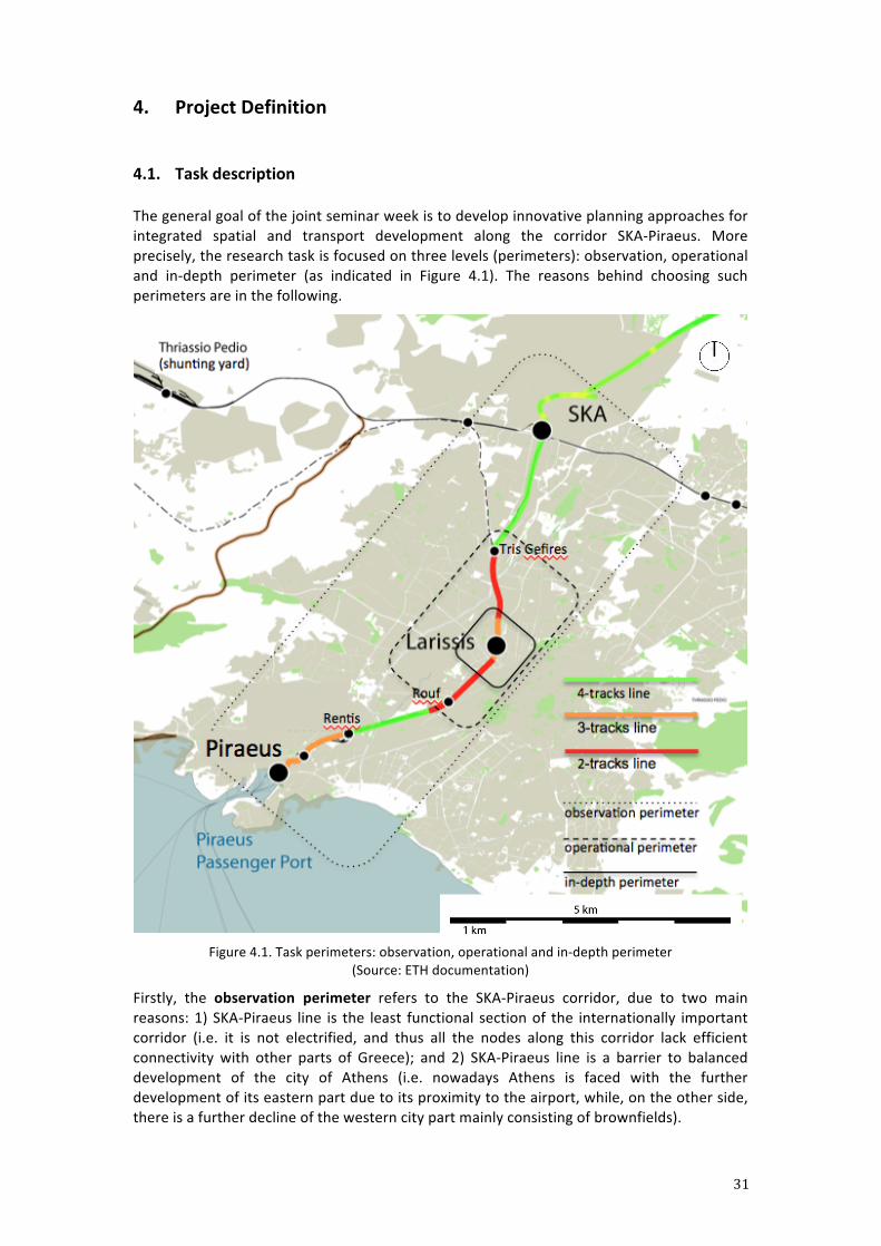
The general goal of the joint seminar week is to develop innovative planning approaches for integrated spatial and transport development along the corridor SKA-‐Piraeus. More precisely, the research task is focused on three levels (perimeters): observation, operational and in-‐depth perimeter (as indicated in Figure 4.1). The reasons behind choosing such perimeters are in the following.
Figure 4.1. Task perimeters: observation, operational and in-‐depth perimeter
(Source: ETH documentation)
Firstly, the observation perimeter refers to the SKA-‐Piraeus corridor, due to two main reasons: 1) SKA-‐Piraeus line is the least functional section of the internationally important corridor (i.e. it is not electrified, and thus all the nodes along this corridor lack efficient connectivity with other parts of Greece); and 2) SKA-‐Piraeus line is a barrier to balanced development of the city of Athens (i.e. nowadays Athens is faced with the further development of its eastern part due to its proximity to the airport, while, on the other side, there is a further decline of the western city part mainly consisting of brownfields).
32
Secondly, the operational perimeter occupies the area between the Tris Gefires node in the north and Rouf station in the south. This section is recognized as a bottleneck due to the following: 1) Tri Gefires-‐Rouf section mainly consists of double-‐track line (as indicated in Figure 4.1); 2) there is a number of levelcrossings along the section (i.e. 5 levelcrossings, 3 overpasses, 2 underpasses) thus disabling the efficient east-‐west transfer; and 3) Rouf station is the border between two municipalities (City of Athens and City of Tavros). All the mentioned spatial demands make the Tris Gefires-‐Rouf section one of the most problematic and, thus, most challenging areas for future integrated spatial and transport development.
Finally, after analyzing the corridor structure, the in-‐depth perimeter focuses on the catchment area of Larissis station. In a nutshell, the research task should aim at creating the main railway station of Athens as both the functional node along the SKA-‐Piraeus corridor and the viable urban centre within Athens city pattern.
The key-‐point research task is to propose a long-‐term solution with forward-‐compatibility (i.e. where each step is compatible with the next and fits future versions of itself). All the recent studies on spatial and railway development in Athens, as well as the technical requirements should be respected and considered. For this, regard to the previous chapters as well as the appendices dealing with the planning structure and technical parameters.
4.2. Expected results The study project will be conducted in teamwork (8 groups with max. 8 members). The final research outcome is in form of 3 A0, each of these dealing with one territorial coverage scale, described in the following.
Namely, the research methodology consists of three levels. First, the Observation Perimeter analyses systemic trends along the railway corridor from SKA to Piraeus. Second, the Operational Perimeter looks more closely into infrastructure networks from Tris Gefires to Rouf. Third, the In-‐depth Perimeter focuses on Larissis station catchment area, around 1km2 from the station.
The methodological steps are the following:
1. OBSERVATION PERIMETER | SKA -‐ PIRAEUS | 1 : 25’000
The Observation Perimeter concerns the regional overview and situation assessment regarding the train network. It contains the following:
-‐ Description of the long term perspective -‐ Concept proposal scheme -‐ Technical overview
a) Track numbers and available land for possible future development b) Electrified and diesel-‐operated routes c) Timetable scheme for the corridor (present and future) d) Where and how to cross the tracks (slow traffic, cars and buses) (present and
future)
2. OPERATIONAL PERIMETER | TRIS GEFIRES -‐ ROUF | 1 : 10’000 -‐ 5’000
This level is concerned with the preferred development direction, namely, the areas of infrastructure, settlement, and landscape. It contains the following:
-‐ SWOT analysis -‐ Concept within the concrete urban pattern -‐ Elaboration of the aims to be achieved by the proposed concept design -‐ Infrastructure proposal
33
a) Private transport network (primary-‐, secondary roads, garages, etc.) b) Public transport network (bus, metro, train) c) Slow mobility network (bicycle, pedestrian) d) Archeological network integration e) Social infrastructures (kindergarten, schools, sport facilities, etc.)
-‐ Built environment proposal a) Public/Open spaces (classification) b) Built areas (classification)
Integrative and stepwise approach regarding infrastructure, settlement and landscape proposal should refer to various time-‐periods, e.g.: immediate measures, short-‐term measures (until 2020), mid-‐term measures (until 2025) and long-‐term measures (later than 2025).
3. IN-‐DEPTH PERIMETER | LARISSIS STATION | 1 : 2’000 -‐ 1’000
This level represents the focus intervention around Larissis station. It should describe the urban planning concept in detail and clarify the strategies proposed to improve the urban quality of the area. The plan contains the following:
-‐ Urban Design Masterplan of Larissis area: a) Transport intermodal layout b) Public/Open spaces (uses/activities on them) c) Built areas (land classification, densities, capacity) -‐ Sections – min 2, max 4 -‐ Volumetric design as 3D model, physical model (optional)
d) Rough cost estimation of overall concept e) Time schedule for project implementation
The project outcome should be presented on 3 DIN A0 posters (portrait orientation) corresponding one for each perimeter. Besides this, textual argumentation on long term perspective, aims and results of the proposed solution should be prepared in 2 DIN A4 documents. Elaboration style of the maps in the A0 posters is free to choose. Both hand-‐made sketches and digital-‐produced maps are allowed as soon as clarity and consistency in the explanation is maintained.
Although Larissis stations counts as the default (and desired) In-‐Depth Perimeter, it is exceptionally allowed to change it to another hot-‐spot along the above mentioned corridor. However, this change should come along a very well funded argumentation justifying the action. If done so, both Operational-‐ as well as In-‐Depth Perimeter should be adapted accordingly to the new situation.
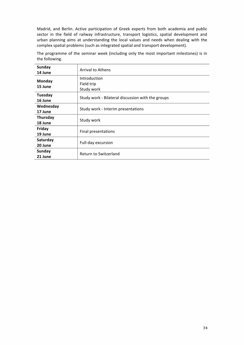
4.3. Organisation
The seminar week takes place in the period between 15 and 20 June 2015 in Athens. The joint workshop is organized by three academic institutions: ETH Zurich, National Technical University of Athens (NTUA), and University of Patras. In total, approx. 55 students from all three universities will participate in the workshop: 20 students from ETH Zurich, 16 students from NTUA and 18 students from the University of Patras.
The preliminary overview on the topic of integrated spatial and transport development is presented to students during the international symposium “Rail&City” (14-‐17 April 2015, Athens), concerned on railway and city development in the context of both European and Greek experiences. More precisely, students are informed about railway development and its integration into existing spatial structure based on the case studies of Vienna, Zurich,
34
Madrid, and Berlin. Active participation of Greek experts from both academia and public sector in the field of railway infrastructure, transport logistics, spatial development and urban planning aims at understanding the local values and needs when dealing with the complex spatial problems (such as integrated spatial and transport development).
The programme of the seminar week (including only the most important milestones) is in the following.
Sunday 14 June Arrival to Athens
Monday 15 June
Introduction Field trip Study work
Tuesday 16 June Study work -‐ Bilateral discussion with the groups
Wednesday 17 June Study work -‐ Interim presentations
Thursday 18 June Study work
Friday 19 June Final presentations
Saturday 20 June Full-‐day excursion
Sunday 21 June Return to Switzerland
35
References Beriatos, E. & Gospodini, A. (2004). ‘‘Urban” landscapes: Athens and the 2004 Olympics. Cities, 21(3),
187-‐202. Chroianopoulos, I., Pagonis, T., Koukoulas, S. & Drymoniti, S. (2010). Planning, competitiveness and
sprawl in the Mediterranean city: The case of Athens. Cities, 27, 249-‐259. ESPON Interstat. (2013). Current context of integrated territorial development strategic planning in
Greece. EU: ESPON. ETH. (2014). Rail and the City: Test-‐planning Process for Patras. Mission. Zurich: ETH. European Communities. (2005). Trans-‐European Transport Network – TEN-‐T priority axes and
projects. Luxembourg: Office for Publications of the European Communities. European Commission (EC). (2011). TEN-‐T Core Network Including Core Network Corridors. Brussels:
EC. Eurostat (2013). Continued recovery in volume of goods handled in EU ports -‐ Issue number 7/2013.
Accessed on 25 May 2014 from http://epp.eurostat.ec.europa.eu/portal/page/portal/product_details/publication?p_product_code=KS-‐SF-‐13-‐007.
Giannakourou, G. (1998). The Spatial Planning System in Greece: a Brief Overview. Proc. European Space and Territorial Integration Alternatives. Accessed on 8 July 2014 from http://www.internationalplanninglaw.com/files_content/Greece%20Planning%20Law%20Gian nakourouBalla.doc.
Hellenic Railway Organisation. (2010). Accessed on 29 June 2014 from http://en.wikipedia.org/wiki/Hellenic_Railways_Organisation#Future_lines.
Iliopoulou, E. (n.d.). New Structural Plan of Attica – Athens: Resource-‐efficient Urban Spatial Development. OPEPA (Organization for Planning and Environmental Protection of Athens) Report.
Kalogianni, I. (2014). Urban transformations of the Larissis station catchment area. Presentation held at the Preparation meeting Rail&City Development in Athens, ETH Zurich, September 18.
Konstandaras, N. (2014). Stabilität, Sicherheit, Eigenheim – das bedeutete in Griechenland Wohlstand. Neue Zürcher Zeitung, s. 16., 31.07.2014
Leontidou, L., Afouxenidis, A., Kourliouros, E. & Marmaras, E. (2007). Infrastructure-‐ related urban sprawl: mega-‐events and hybrid peri-‐urban landscapes in Southern Europe. In C. Couch, L. Leontidou & G. Petschel-‐Held (Eds.), Urban Sprawl in Europe: Landscapes, Land-‐use Change and Policy, 71-‐101. Blackwell, Oxford.
Maloutas, T. (2003). Promoting social sustainability -‐ The case of Athens. City, 7 (2): 165-‐179. Nagy, E., Nagy, G., Timar, J., Mangels, K., Schrader-‐Bolsche, N. & Berdavs, J. (n.d.). Transnational
comparison of national policies and planning systems. Report of the WP3/Action 3.2. South east Europe Transnational cooperation programme “Integrated Urban Development of Vital Historic Towns as Regional Centres in South East Europe”.
OECD (Organisation for Economic Co-‐operation and Development). (2003). The review of Athens. 5th Session of the Working Party on Territorial Policy in Urban Areas, 22 October 2003, Sevilla, Spain. Public Governance and Territorial Development Directorate, Territorial Development Committee.
OECD (Organisation for Economic Co-‐operation and Development). (2010). Transcontinental Infrastructure Needs to 2030/2050: North-‐West Europe Gateway Area – Port of Rotterdam Case Study. OECD final report of Workshop, November 2010. Public Governance and Territorial Development Directorate, Territorial Development Committee.
OPEPA (Organization for Planning and Environmental Protection of Athens). (2011). Strategic Plan for Athens/Attica. Report.
Panepistimiou pedestrianization and Faliro Bay redevelopment at risk. (2014). Accessed on 2 December 2014 from http://www.tovima.gr/en/article/?aid=653357.
Pantelas, G. (2014). Railway development in Greece: The corridor of Piraeus to Athens and the railway
36
station of Athens (Larissis station). Presentation held at the Preparation meeting Rail&City Development in Athens, ETH Zurich, September 18.
Railways of Greece. (n.d.). Accessed on 29 June 2014 from http://en.wikipedia.org/wiki/Railways_of_Greece#Current_status.
Scholl, B. (Ed.) (2012). Spaces and Projects of National Importance − SAPONI. Zürich: VDF ETH. Serraos, K., Gianniris, E. & Zifou, M. (n.d.). The Greek spatial planning system in the European context. The Ikonio-‐Thriasio rail line. (2013). Accessed on 1 December 2014 from
https://oncosco.wordpress.com/2013/03/11/the-‐ikonio-‐thriasio-‐rail-‐line/. TrainOSE. (n.d.) Accessed on 29 June 2014 from http://en.wikipedia.org/wiki/TrainOSE. USESPON. (2013). National Spatial Planning and Sustainable Development Framework (in Greek).
Accessed on 15 July 2014 from http://www.espon-‐usespon.eu/library,national-‐spatial-‐planning-‐and-‐sustainable-‐development-‐framework-‐7cbb.
ΦΕΚ 128Α 03/07/2008. National Spatial Planning and Sustainable Development Framework (in Greek).
http://ose.gr http://ergose.gr http://gaiaose.com http://www.rethinkathens.org
37
A 1: Spatial Planning in Greece
1. Spatial problems and challenges in Greece
The Greek spatial planning system seems currently to be influenced mainly by two factors. The first one concerns more general changes in the field of the Greek administrative and institutional framework (for example decentralization and deregulation process), while the second one is focused on the impact of European policies on the Greek spatial planning system (Serraos, Gianniris & Zifou, n.d.). Highlighting the urban-‐rural dichotomy, which is accompanied by the inflow of population in the urban centres, Greek spatial planning authorities have to deal with a lot of spatial problems, such as (Nagy et al, n.d.):
-‐ Unclear responsibilities in the domain of spatial planning and development6; -‐ Deficits of the infrastructure; -‐ Malfunctions of the transport system resulting from infrastructure and
organizational deficits; -‐ Overdevelopment of private space at expense of the public space; -‐ Urban sprawl and the existing rule of “ex post” planning; -‐ Restructuring of cities and their cultural centres that included upheavals of
functionality and property; -‐ High risk of malfunction and degradation of districts as a result of increasing
segregation and social exclusion; -‐ Increasing pollution.
Concerning these problems, the government is trying to cope with the social and economic disparities, but there is a wide gap between the theory and praxis. The influence of the European policy and especially the development funds take an important part by the restructuring of the spatial planning system and implementation of cohesion policy (Nagy et al, n.d.; Chroianopoulos et al., 2010). Thus, there are several basic challenges affecting spatial planning in Greece, such as:
-‐ Spatial planning framework is complex and characterized by a rigid top-‐down approach that lacks clarity;
-‐ Spatial planning is generally understood to be product-‐oriented, i.e. it is concentrated on the production of individual plans rather than on pursuing a continuous and integrated planning process;
-‐ The planning horizon of the politicians is four to eight years, i.e. one or two mandates, which influences the actual planning horizon of the public authorities;
-‐ The decision procedures are numerous and unclear; -‐ There is a lack of coordination among planning authorities belonging to different
levels (national, regional, metropolitan, municipality), as well as between representatives of different sectors (i.e. public and private).
6 The importance of spatial planning has decreased in the last year of the economic crisis. For that reason, spatial relevant decisions of extreme importance for local, regional, and national level are made by irrelevant authorities and not by the ministry in charge of spatial planning (YPEKA). The striking example is the government’s attempt to change the official definition of the coastal zone in order to attract big investments in the touristic sector in Greece. The result of such change would be the development of the touristic complexes according to the model of Costa del Sol in Spain. Not surprisingly, the draft of the new law has been created by the Ministry of Finance. Nevertheless, due to the fact that it was against the Greek and the European constitutional laws, it did not get through the Greek Parliament.
38
2. Institutional framework of spatial planning In Greece, urban and regional planning was for a long time the sole responsibility of the central state. However, in the 1980s and mainly in the 1990s, regional administrations and local authorities were given more power and planning responsibilities through a process of decentralization (Giannakourou, 1998). However, in recent times more power and responsibilities on spatial planning issues were delegated to regional and local level (Nagy et al, n.d.). More precisely, since 1 January 2011, in accordance with the Kallikratis plan (Law 3852/2010), the administrative system of Greece was drastically overhauled7. Greek national state nowadays comprises: 7 decentralized administrations, 13 regions, 74 regional units and 325 municipalities. Thus, spatial planning in Greece is carried out at three levels: national, regional and local.
National level. The Ministry responsible for the field of spatial planning is the Ministry of Environment, Energy and Climate Change (YPEKA). It is responsible for the elaboration, approval and implementation of urban master plans, statutory town plans, housing plans and environmental protection programs. It is also responsible for the elaboration, monitoring, evaluation and revision of national and regional strategic spatial plans. Other ministries, responsible for sectors as industry, tourism, agriculture, transport and energy, intervene also in the formulation and implementation of spatial planning policy especially in the field of sectoral spatial plans (Giannakourou, 1998; Nagy et al, n.d.). The planning horizon is 15 years.
Regional level. Greece is divided into 13 regions 8 . Regional planning authorities are concerned mainly with the elaboration, the approval, the amendment, the revision and the monitoring and control of different types of national planning guidelines on spatial structure, land use, infrastructure and settlement networks, town plans, housing and building regulations (Nagy et al, n.d.). Also, the responsibilities of regional authorities relate to the approval of zones for the transfer of floor-‐area ratio and the approval of departures from general building rules in the case of non-‐residential buildings, such as: buildings used for health care, education and welfare services, as well as industrial plants and public sports facilities (ESPON, 2013). The planning horizon for regional plans is also 15 years.
Local level. In the production and approval of statutory plans the role of local authorities (i.e. regional units and municipalities) is mostly advisory, while the core of their responsibilities is concerned with the delivery of building permits and other licenses and the implementation of town plans (Giannakourou, 1998; Nagy et al, n.d.). Besides regional and local authorities, a great number of government agencies and public sector organizations intervene in the spatial planning process, especially at implementation stage. Among them, we should mention the “Athens Organization” and the “Thessaloniki Organization”, respectively responsible for the implementation and the monitoring of the Master Plans of Athens and Thessaloniki (ESPON, 2013).
3. Spatial planning instruments Greek planning law comprises a wide range of instruments which extent from strategic and framework plans at the national and regional levels to regulatory town plans and zones at the local level. Existing legislation establishes a hierarchical structure between different types of plans with the higher tier being binding on the tiers below it. The organization of
7 The former administrative system of Greece consisted of: 13 regions, 54 prefectures and 1033 municipalities and communities. 8 The regions are consolidated decentralized units of state administration that ensure that state policies can be administered at a more local level (Giannakourou, 1998).
39
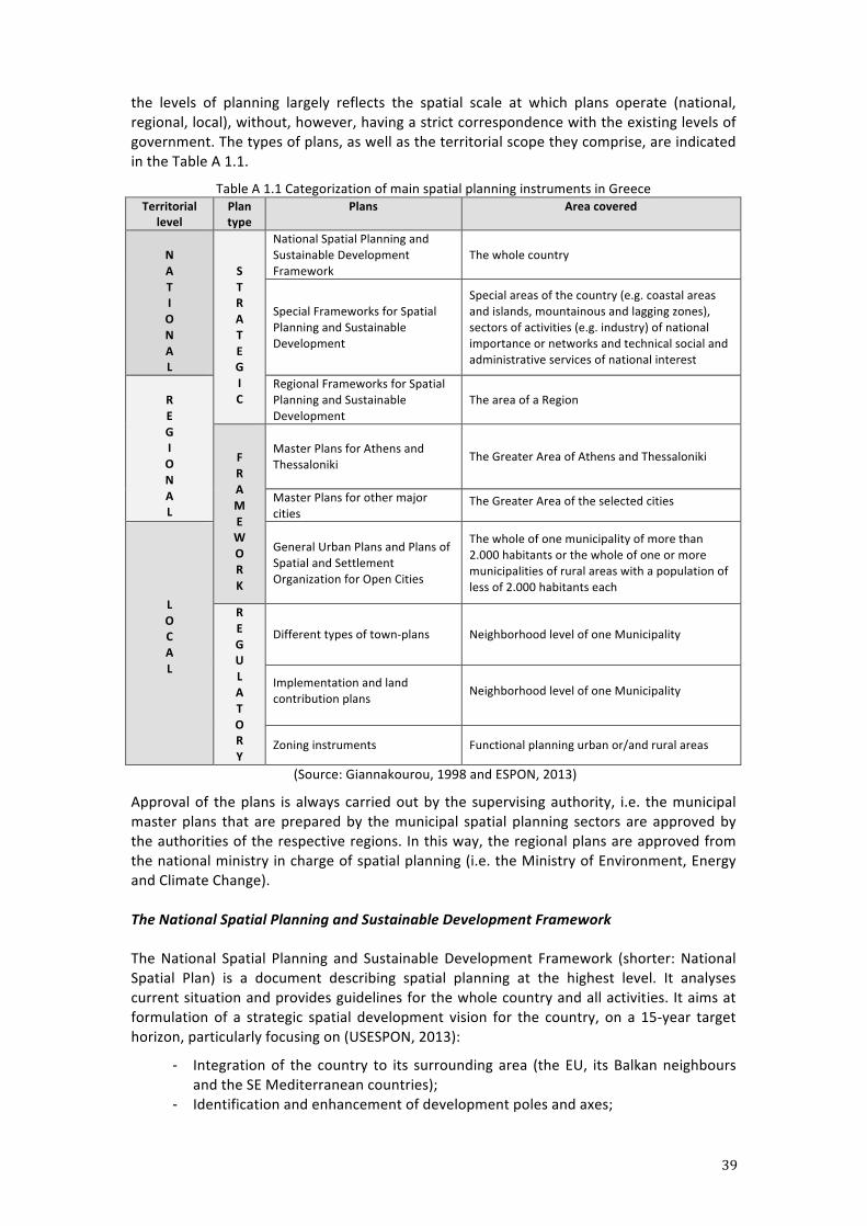
the levels of planning largely reflects the spatial scale at which plans operate (national, regional, local), without, however, having a strict correspondence with the existing levels of government. The types of plans, as well as the territorial scope they comprise, are indicated in the Table A 1.1.
Table A 1.1 Categorization of main spatial planning instruments in Greece Territorial
level Plan type
Plans Area covered
N A T I O N A L
S T R A T E G I C
National Spatial Planning and Sustainable Development Framework
The whole country
Special Frameworks for Spatial Planning and Sustainable Development
Special areas of the country (e.g. coastal areas and islands, mountainous and lagging zones), sectors of activities (e.g. industry) of national importance or networks and technical social and administrative services of national interest
R E G I O N A L
Regional Frameworks for Spatial Planning and Sustainable Development
The area of a Region
F R A M E W O R K
Master Plans for Athens and Thessaloniki
The Greater Area of Athens and Thessaloniki
Master Plans for other major cities
The Greater Area of the selected cities
L O C A L
General Urban Plans and Plans of Spatial and Settlement Organization for Open Cities
The whole of one municipality of more than 2.000 habitants or the whole of one or more municipalities of rural areas with a population of less of 2.000 habitants each
R E G U L A T O R Y
Different types of town-‐plans Neighborhood level of one Municipality
Implementation and land contribution plans Neighborhood level of one Municipality
Zoning instruments Functional planning urban or/and rural areas
(Source: Giannakourou, 1998 and ESPON, 2013)
Approval of the plans is always carried out by the supervising authority, i.e. the municipal master plans that are prepared by the municipal spatial planning sectors are approved by the authorities of the respective regions. In this way, the regional plans are approved from the national ministry in charge of spatial planning (i.e. the Ministry of Environment, Energy and Climate Change). The National Spatial Planning and Sustainable Development Framework
The National Spatial Planning and Sustainable Development Framework (shorter: National Spatial Plan) is a document describing spatial planning at the highest level. It analyses current situation and provides guidelines for the whole country and all activities. It aims at formulation of a strategic spatial development vision for the country, on a 15-‐year target horizon, particularly focusing on (USESPON, 2013):
-‐ Integration of the country to its surrounding area (the EU, its Balkan neighbours and the SE Mediterranean countries);
-‐ Identification and enhancement of development poles and axes;
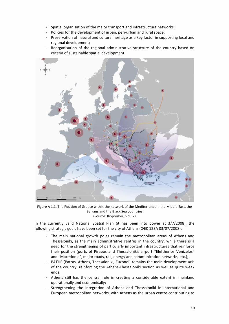
40
-‐ Spatial organisation of the major transport and infrastructure networks; -‐ Policies for the development of urban, peri-‐urban and rural space; -‐ Preservation of natural and cultural heritage as a key factor in supporting local and
regional development; -‐ Reorganisation of the regional administrative structure of the country based on
criteria of sustainable spatial development.
Figure A 1.1. The Position of Greece within the network of the Mediterranean, the Middle East, the
Balkans and the Black Sea countries (Source: Iliopoulou, n.d.: 2)
In the currently valid National Spatial Plan (it has been into power at 3/7/2008), the following strategic goals have been set for the city of Athens (ΦΕΚ 128Α 03/07/2008):
-‐ The main national growth poles remain the metropolitan areas of Athens and Thessaloniki, as the main administrative centres in the country, while there is a need for the strengthening of particularly important infrastructures that reinforce their position (ports of Piraeus and Thessaloniki; airport “Eleftherios Venizelos” and “Macedonia”, major roads, rail, energy and communication networks, etc.);
-‐ PATHE (Patras, Athens, Thessaloniki, Euzonoi) remains the main development axis of the country, reinforcing the Athens-‐Thessaloniki section as well as quite weak ends;
-‐ Athens still has the central role in creating a considerable extent in mainland operationally and economically;
-‐ Strengthening the integration of Athens and Thessaloniki in international and European metropolitan networks, with Athens as the urban centre contributing to
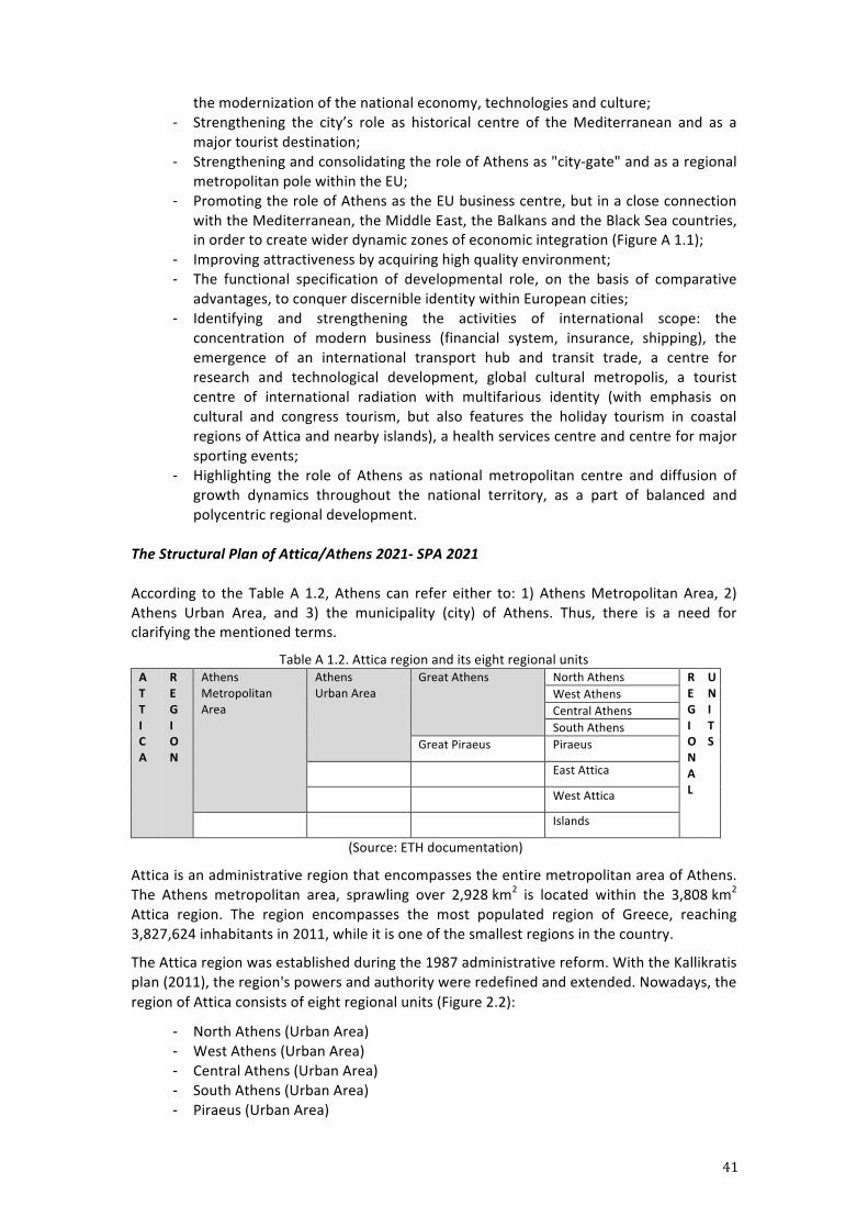
41
the modernization of the national economy, technologies and culture; -‐ Strengthening the city’s role as historical centre of the Mediterranean and as a
major tourist destination; -‐ Strengthening and consolidating the role of Athens as "city-‐gate" and as a regional
metropolitan pole within the EU; -‐ Promoting the role of Athens as the EU business centre, but in a close connection
with the Mediterranean, the Middle East, the Balkans and the Black Sea countries, in order to create wider dynamic zones of economic integration (Figure A 1.1);
-‐ Improving attractiveness by acquiring high quality environment; -‐ The functional specification of developmental role, on the basis of comparative
advantages, to conquer discernible identity within European cities; -‐ Identifying and strengthening the activities of international scope: the
concentration of modern business (financial system, insurance, shipping), the emergence of an international transport hub and transit trade, a centre for research and technological development, global cultural metropolis, a tourist centre of international radiation with multifarious identity (with emphasis on cultural and congress tourism, but also features the holiday tourism in coastal regions of Attica and nearby islands), a health services centre and centre for major sporting events;
-‐ Highlighting the role of Athens as national metropolitan centre and diffusion of growth dynamics throughout the national territory, as a part of balanced and polycentric regional development.
The Structural Plan of Attica/Athens 2021-‐ SPA 2021 According to the Table A 1.2, Athens can refer either to: 1) Athens Metropolitan Area, 2) Athens Urban Area, and 3) the municipality (city) of Athens. Thus, there is a need for clarifying the mentioned terms.
Table A 1.2. Attica region and its eight regional units A T T I C A
R E G I O N
Athens Metropolitan Area
Athens Urban Area
Great Athens North Athens R E G I O N A L
U N I T S
West Athens Central Athens South Athens
Great Piraeus Piraeus
East Attica
West Attica
Islands
(Source: ETH documentation)
Attica is an administrative region that encompasses the entire metropolitan area of Athens. The Athens metropolitan area, sprawling over 2,928 km2 is located within the 3,808 km2 Attica region. The region encompasses the most populated region of Greece, reaching 3,827,624 inhabitants in 2011, while it is one of the smallest regions in the country.
The Attica region was established during the 1987 administrative reform. With the Kallikratis plan (2011), the region's powers and authority were redefined and extended. Nowadays, the region of Attica consists of eight regional units (Figure 2.2):
-‐ North Athens (Urban Area) -‐ West Athens (Urban Area) -‐ Central Athens (Urban Area) -‐ South Athens (Urban Area) -‐ Piraeus (Urban Area)
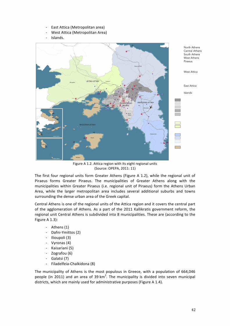
42
-‐ East Attica (Metropolitan area) -‐ West Attica (Metropolitan Area) -‐ Islands.
Figure A 1.2. Attica region with its eight regional units
(Source: OPEPA, 2011: 11)
The first four regional units form Greater Athens (Figure A 1.2), while the regional unit of Piraeus forms Greater Piraeus. The municipalities of Greater Athens along with the municipalities within Greater Piraeus (i.e. regional unit of Piraeus) form the Athens Urban Area, while the larger metropolitan area includes several additional suburbs and towns surrounding the dense urban area of the Greek capital.
Central Athens is one of the regional units of the Attica region and it covers the central part of the agglomeration of Athens. As a part of the 2011 Kallikratis government reform, the regional unit Central Athens is subdivided into 8 municipalities. These are (according to the Figure A 1.3):
-‐ Athens (1) -‐ Dafni-‐Ymittos (2) -‐ Ilioupoli (3) -‐ Vyronas (4) -‐ Kaisariani (5) -‐ Zografou (6) -‐ Galatsi (7) -‐ Filadelfeia-‐Chalkidona (8)
The municipality of Athens is the most populous in Greece, with a population of 664,046 people (in 2011) and an area of 39 km2. The municipality is divided into seven municipal districts, which are mainly used for administrative purposes (Figure A 1.4).
North Athens Central Athens South Athens West Athens Piraeus
West Attica
East Attica
Islands
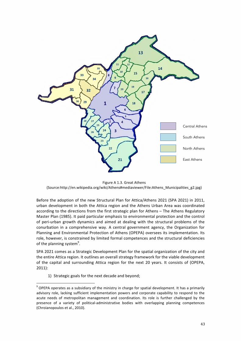
43
Figure A 1.3. Great Athens (Source:http://en.wikipedia.org/wiki/Athens#mediaviewer/File:Athens_Municipalities_g2.jpg)
Before the adoption of the new Structural Plan for Attica/Athens 2021 (SPA 2021) in 2011, urban development in both the Attica region and the Athens Urban Area was coordinated according to the directions from the first strategic plan for Athens – The Athens Regulatory Master Plan (1985). It paid particular emphasis to environmental protection and the control of peri-‐urban growth dynamics and aimed at dealing with the structural problems of the conurbation in a comprehensive way. A central government agency, the Organization for Planning and Environmental Protection of Athens (OPEPA) oversees its implementation. Its role, however, is constrained by limited formal competences and the structural deficiencies of the planning system9.
SPA 2021 comes as a Strategic Development Plan for the spatial organization of the city and the entire Attica region. It outlines an overall strategy framework for the viable development of the capital and surrounding Attica region for the next 20 years. It consists of (OPEPA, 2011):
1) Strategic goals for the next decade and beyond; 9 OPEPA operates as a subsidiary of the ministry in charge for spatial development. It has a primarily advisory role, lacking sufficient implementation powers and corporate capability to respond to the acute needs of metropolitan management and coordination. Its role is further challenged by the presence of a variety of political-‐administrative bodies with overlapping planning competences (Chroianopoulos et al., 2010).
Central Athens
South Athens
North Athens
East Athens
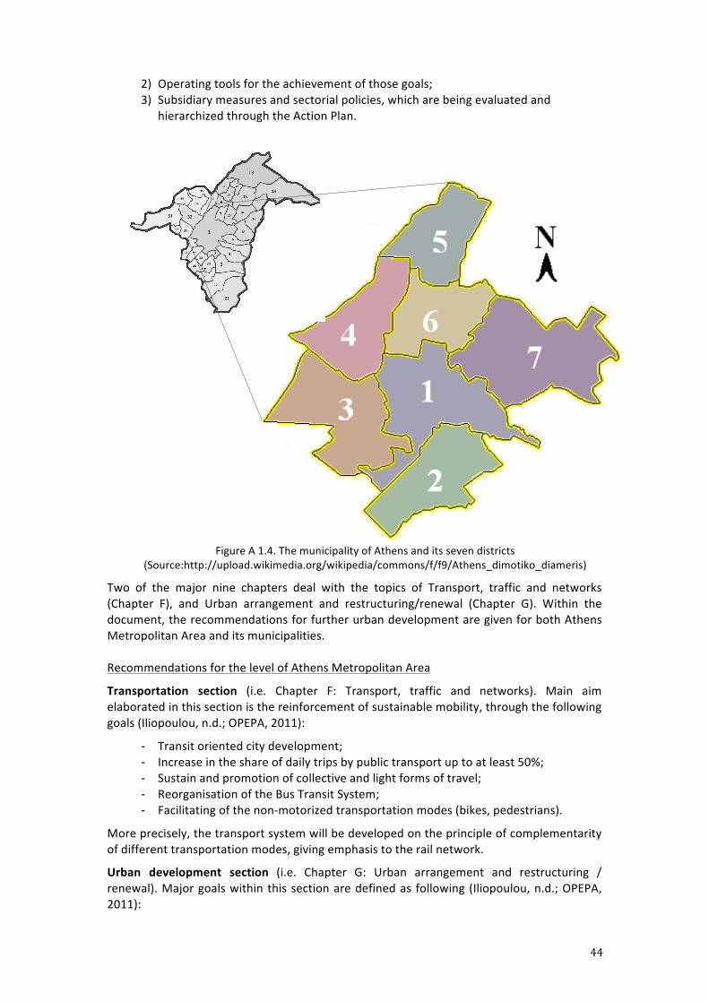
44
2) Operating tools for the achievement of those goals; 3) Subsidiary measures and sectorial policies, which are being evaluated and
hierarchized through the Action Plan.
Figure A 1.4. The municipality of Athens and its seven districts
(Source:http://upload.wikimedia.org/wikipedia/commons/f/f9/Athens_dimotiko_diameris)
Two of the major nine chapters deal with the topics of Transport, traffic and networks (Chapter F), and Urban arrangement and restructuring/renewal (Chapter G). Within the document, the recommendations for further urban development are given for both Athens Metropolitan Area and its municipalities. Recommendations for the level of Athens Metropolitan Area
Transportation section (i.e. Chapter F: Transport, traffic and networks). Main aim elaborated in this section is the reinforcement of sustainable mobility, through the following goals (Iliopoulou, n.d.; OPEPA, 2011):
-‐ Transit oriented city development; -‐ Increase in the share of daily trips by public transport up to at least 50%; -‐ Sustain and promotion of collective and light forms of travel; -‐ Reorganisation of the Bus Transit System; -‐ Facilitating of the non-‐motorized transportation modes (bikes, pedestrians).
More precisely, the transport system will be developed on the principle of complementarity of different transportation modes, giving emphasis to the rail network.
Urban development section (i.e. Chapter G: Urban arrangement and restructuring / renewal). Major goals within this section are defined as following (Iliopoulou, n.d.; OPEPA, 2011):
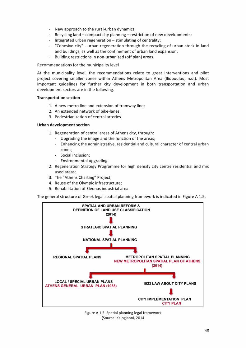
45
-‐ New approach to the rural-‐urban dynamics; -‐ Recycling land – compact city planning – restriction of new developments; -‐ Integrated urban regeneration – stimulating of centrality; -‐ “Cohesive city” -‐ urban regeneration through the recycling of urban stock in land
and buildings, as well as the confinement of urban land expansion; -‐ Building restrictions in non-‐urbanized (off plan) areas.
Recommendations for the municipality level
At the municipality level, the recommendations relate to great interventions and pilot project covering smaller zones within Athens Metropolitan Area (Iliopoulou, n.d.). Most important guidelines for further city development in both transportation and urban development sectors are in the following.
Transportation section
1. A new metro line and extension of tramway line; 2. An extended network of bike-‐lanes; 3. Pedestrianization of central arteries.
Urban development section
1. Regeneration of central areas of Athens city, through: -‐ Upgrading the image and the function of the areas; -‐ Enhancing the administrative, residential and cultural character of central urban
zones; -‐ Social inclusion; -‐ Environmental upgrading.
2. Regeneration Strategy Programme for high density city centre residential and mix used areas;
3. The “Athens Charting” Project; 4. Reuse of the Olympic infrastructure; 5. Rehabilitation of Eleonas industrial area.
The general structure of Greek legal spatial planning framework is indicated in Figure A 1.5.
Figure A 1.5. Spatial planning legal framework
(Source: Kalogianni, 2014
STRATEGIC SPATIAL PLANNING
SPATIAL AND URBAN REFORM & DEFINITION OF LAND USE CLASSIFICATION
(2014)
METROPOLITAN SPATIAL PLANNING NEW METROPOLITAN SPATIAL PLAN OF ATHENS
(2014)
NATIONAL SPATIAL PLANNING
REGIONAL SPATIAL PLANS
LOCAL / SPECIAL URBAN PLANS ATHENS GENERAL URBAN PLAN (1988)
CITY IMPLEMENTATION PLAN CITY PLAN
1923 LAW ABOUT CITY PLANS
46
A 2: Urban Regeneration Initiatives in Athens
1. The Unification of the Archaeological Sites of Athens (EAXA): The creation of
the archaeological bow In 1997, a new planning company was founded by the Ministry of planning and the Ministry of culture. The concept was to turn the historical city center of Athens into an open-‐air museum through the creation of a pedestrian network of archaeological sites, public open spaces, cultural monuments, and buildings of architectural interest. The unification of the archaeological sites of Athens was in the core of this vision, well known as ‘the archaeological bow’, or more romantic ‘the big stroll’.
This ambitious programme is divided in 6 spatial units:
1. Kerameikos, Piraeus r., Iera Odos r., Gazi, Thisseio; 2. Ancient Agora, Roman Agora, Plaka, Bibliothek of Adrianos; 3. Acropolis hill, pedestrian axes of Dionyssiou Areopagitou, Apostolou Pavlou,
Filopappou, Makrygianni; 4. Akadimia Platonos, Metaxourgeio, Psirri; 5. Commercial District (enclosed by the streets Stadiou, Mitropoleos, Ermou, and
Athinas), as well as the area of Monastiraki; 6. Olympieion, Zappeion, Panathinaikon Stadion, and Ardittos Hill in the eastern
part.10
Up to now, some pedestrian zones (with the most significant – the stroll around the Acropolis Hill) have been realized which changed dramatically the quality of the urban space in the historical centre. Another project was the architectural competition for the redesign of 4 central public squares (Syntagma, Monastiraki, Koumoundourou, Omonia). The Omonia project is considered as a failure. The extension of the programme will include the Iera Odos road (in translation: the Holy Street) and Elevsina with its archaeological site of the highest importance.
2. Rethink Athens On 27 February 2013, the Alexander S. Onassis Public Benefit Foundation launched a European architectural competition for the re-‐constitution of Athens city centre along the axis of Panepistimiou Street. The plan, called ‘One step beyond’ is the winning proposal for Onassis’s Rethink Athens, aspiring to create an accessible and vibrant city centre for gathering, commerce and living. The ambitious regeneration project hopes to bring contemporary ideas on climate control in cities, ideas on changing transportation nodes and on activating public realm a step further than already realized in many European cities.
Under this project, Panepistimiou Avenue is set to become off-‐limits to private cars. Instead, it will be covered with natural heat-‐absorbing materials, planted with trees and crossed by new tramway tracks as well as the first bicycle lane to be constructed in the centre of Athens (Picture A 2.1).
10 The 1st and the 4th spatial unit are in a strong spatial correlation with the district around the Larissis station.
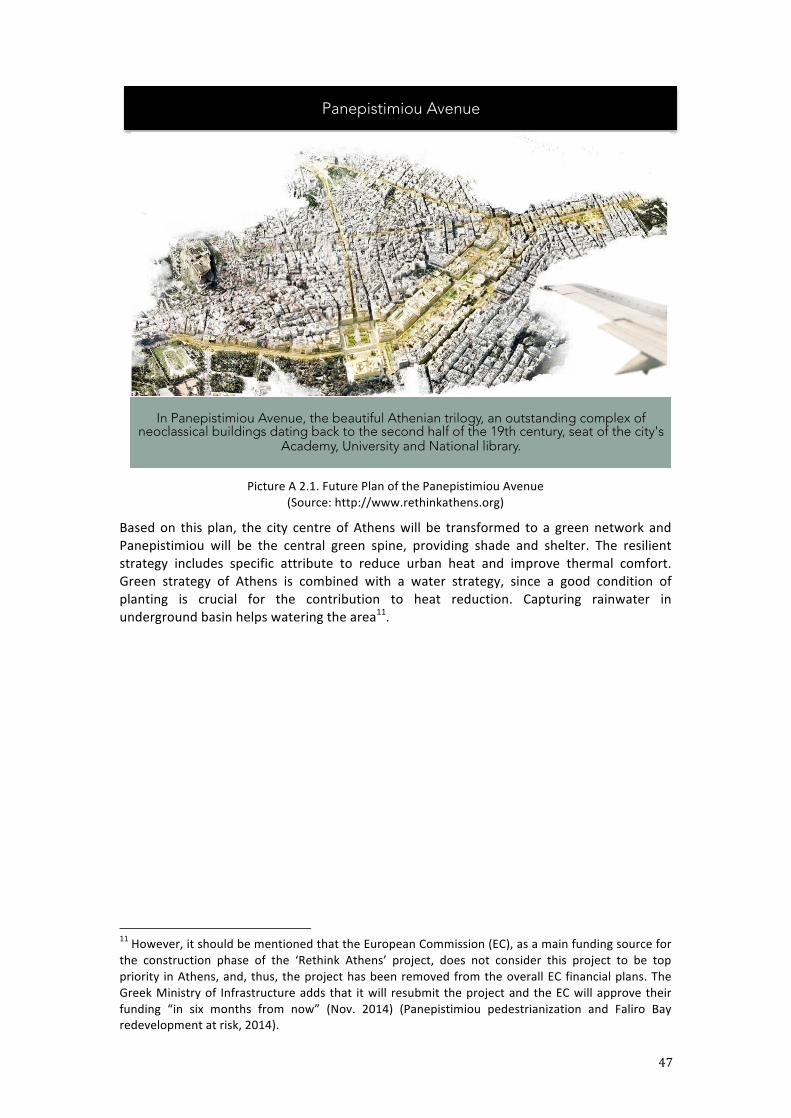
47
Picture A 2.1. Future Plan of the Panepistimiou Avenue
(Source: http://www.rethinkathens.org)
Based on this plan, the city centre of Athens will be transformed to a green network and Panepistimiou will be the central green spine, providing shade and shelter. The resilient strategy includes specific attribute to reduce urban heat and improve thermal comfort. Green strategy of Athens is combined with a water strategy, since a good condition of planting is crucial for the contribution to heat reduction. Capturing rainwater in underground basin helps watering the area11.
11 However, it should be mentioned that the European Commission (EC), as a main funding source for the construction phase of the ‘Rethink Athens’ project, does not consider this project to be top priority in Athens, and, thus, the project has been removed from the overall EC financial plans. The Greek Ministry of Infrastructure adds that it will resubmit the project and the EC will approve their funding “in six months from now” (Nov. 2014) (Panepistimiou pedestrianization and Faliro Bay redevelopment at risk, 2014).
Panepistimiou Avenue
In Panepistimiou Avenue, the beautiful Athenian trilogy, an outstanding complex of neoclassical buildings dating back to the second half of the 19th century, seat of the city's
Academy, University and National library.
48
A 3: Rail Technical Parameters Dr. Rolf Signer, Dr. Markus Nollert, Hans-‐Peter Vetsch
Contents
1. Relevance of this annex 2. Recent development of railway services in Greece 3. Plans of railway infrastructure by OSE in Greece and Attika region 4. Recent development of railway infrastructure development and services in the
observation perimeter 5. Current situation of railway infrastructure and services in the observation perimeter 6. Plans of railway infrastructure and services in the working perimeter by OSE 7. Guiding principles for the development of the working perimeter 8. Sample collection of rolling stock 1. Relevance of this annex
This document contains some more detailled information about railway items for the partici-‐pants in the joint seminar week in Athens complementing the task definition.
It first gives some overview about Greek railway development in the recent years. This con-‐cerns regional, national as well as international rail-‐traffic. Plans for the Greek railway system are described in the following section. The next section deals with the latest development in the observation perimeter (SKA-‐Pi-‐raeus). An important part is the current situation of railway infrastructure and services in the operational (working) perimeter (Tris Gefires-‐Rouf). The plans of OSE for railway infrastructure and services in the working perimeter are described in the next section. Some guiding principles for the development of the working perimeter are shown next. Finally, a sample collection of rolling stock will be presented.
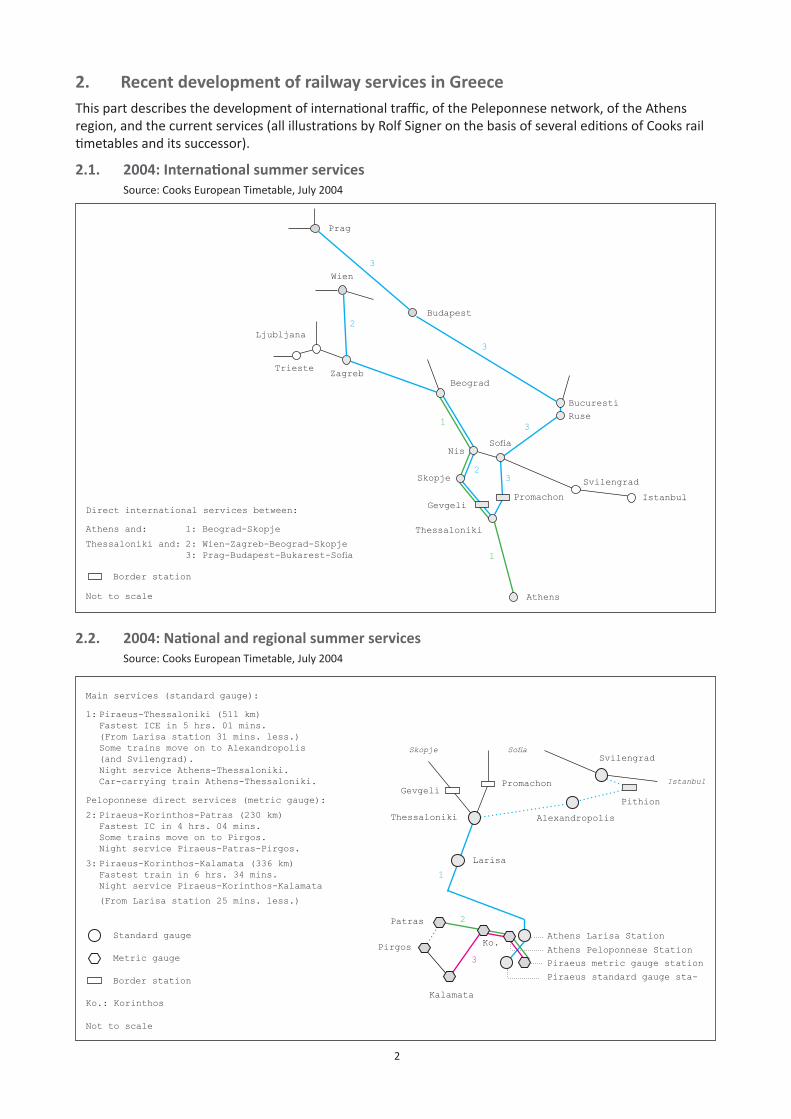
2
2. Recent development of railway services in GreeceThis part describes the development of international traffic, of the Peleponnese network, of the Athens region, and the current services (all illustrations by Rolf Signer on the basis of several editions of Cooks rail timetables and its successor).
2.1. 2004:Internationalsummerservices Source: Cooks European Timetable, July 2004
Budapest
Trieste
Ljubljana
ZagrebBeograd
Bucuresti
SofiaNis
Skopje
Thessaloniki
Svilengrad
Istanbul
Athens
Ruse
PromachonGevgeli
Promachon
Thessaloniki
Svilengrad
Alexandropolis
Larisa
Athens Larisa Station
Patras
Pirgos
Kalamata
GevgeliPithion
Sofia
2.2. 2004:Nationalandregionalsummerservices Source: Cooks European Timetable, July 2004
Direct international services between:
Athens and: 1: Beograd-Skopje
Thessaloniki and: 2: Wien-Zagreb-Beograd-Skopje 3:Prag-Budapest-Bukarest-Sofia
Wien
Prag
3
3
2
2
1
3
3
Border station
Not to scale
Not to scale
Border station
Standard gauge
Metric gaugeAthens Peloponnese Station
1
Main services (standard gauge):
1: Piraeus-Thessaloniki (511 km) Fastest ICE in 5 hrs. 01 mins. (From Larisa station 31 mins. less.) Some trains move on to Alexandropolis
(and Svilengrad). Night service Athens-Thessaloniki. Car-carrying train Athens-Thessaloniki.
Peloponnese direct services (metric gauge):
2: Piraeus-Korinthos-Patras (230 km) Fastest IC in 4 hrs. 04 mins. Some trains move on to Pirgos. Night service Piraeus-Patras-Pirgos.
3: Piraeus-Korinthos-Kalamata (336 km) Fastest train in 6 hrs. 34 mins. Night service Piraeus-Korinthos-Kalamata
(From Larisa station 25 mins. less.)
1
Istanbul
2
Ko.
Ko.: Korinthos
3
Skopje
Piraeus standard gauge sta-
Piraeus metric gauge station
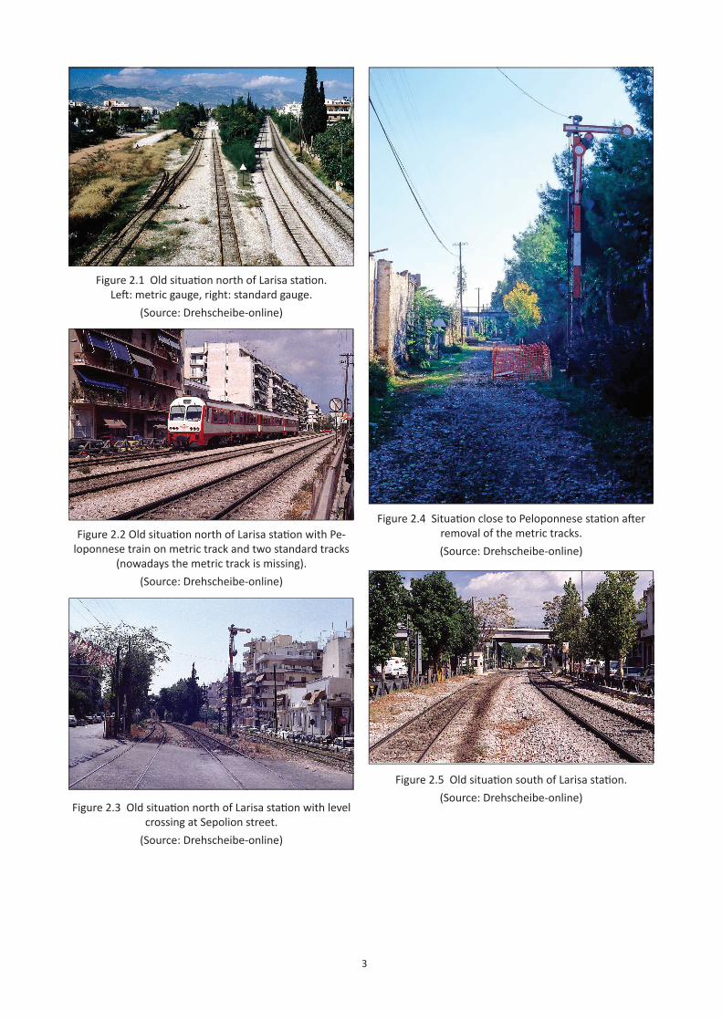
3
Figure 2.1 Old situati on north of Larisa stati on. Left : metric gauge, right: standard gauge.
(Source: Drehscheibe-online)
Figure 2.2 Old situati on north of Larisa stati on with Pe-loponnese train on metric track and two standard tracks
(nowadays the metric track is missing).(Source: Drehscheibe-online)
Figure 2.3 Old situati on north of Larisa stati on with level crossing at Sepolion street.
(Source: Drehscheibe-online)
Figure 2.4 Situati on close to Peloponnese stati on aft er removal of the metric tracks.(Source: Drehscheibe-online)
Figure 2.5 Old situati on south of Larisa stati on.(Source: Drehscheibe-online)
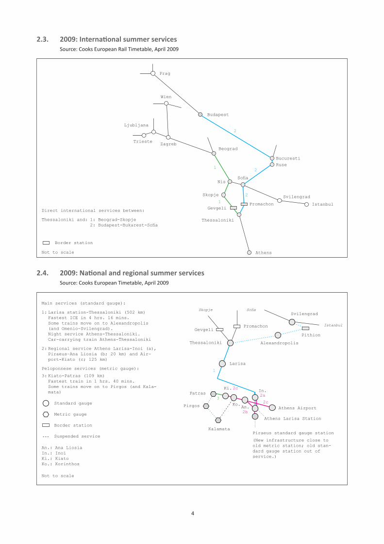
4
2.3. 2009:Internationalsummerservices Source: Cooks European Rail Timetable, April 2009
Budapest
Trieste
Ljubljana
ZagrebBeograd
Bucuresti
SofiaNis
Skopje
Thessaloniki
Svilengrad
Istanbul
Athens
Ruse
PromachonGevgeliDirect international services between:
Thessaloniki and: 1: Beograd-Skopje 2:Budapest-Bukarest-Sofia
Wien
Prag
21
2
2
Border station
Not to scale
1
Promachon
Thessaloniki
Svilengrad
Alexandropolis
Larisa
Patras
Pirgos
Kalamata
GevgeliPithion
Sofia
2.4. 2009:Nationalandregionalsummerservices Source: Cooks European Timetable, April 2009
Not to scale
Border station
Standard gauge
Metric gauge
Main services (standard gauge):
1: Larisa station-Thessaloniki (502 km) Fastest ICE in 4 hrs. 16 mins. Some trains move on to Alexandropolis
(and Omenio-Svilengrad). Night service Athens-Thessaloniki. Car-carrying train Athens-Thessaloniki
2: Regional service Athens Larisa-Inoi (a), Piraeus–Ana Liosia (b; 20 km) and Air-
port-Kiato (c; 125 km)
Peloponnese services (metric gauge):
3: Kiato-Patras (109 km) Fastest train in 1 hrs. 40 mins. Some trains move on to Pirgos (and Kala-
mata)
1
Istanbul
3Ko.
An.: Ana LiosiaIn.: InoiKi.: KiatoKo.: Korinthos
2a
Skopje
Athens Larisa Station
Piraeus standard gauge station
(New infrastructure close to old metric station; old stan-dard gauge station out of service.)
Ki.
Athens AirportAn.
In.
2b
2c
2c
Suspended service
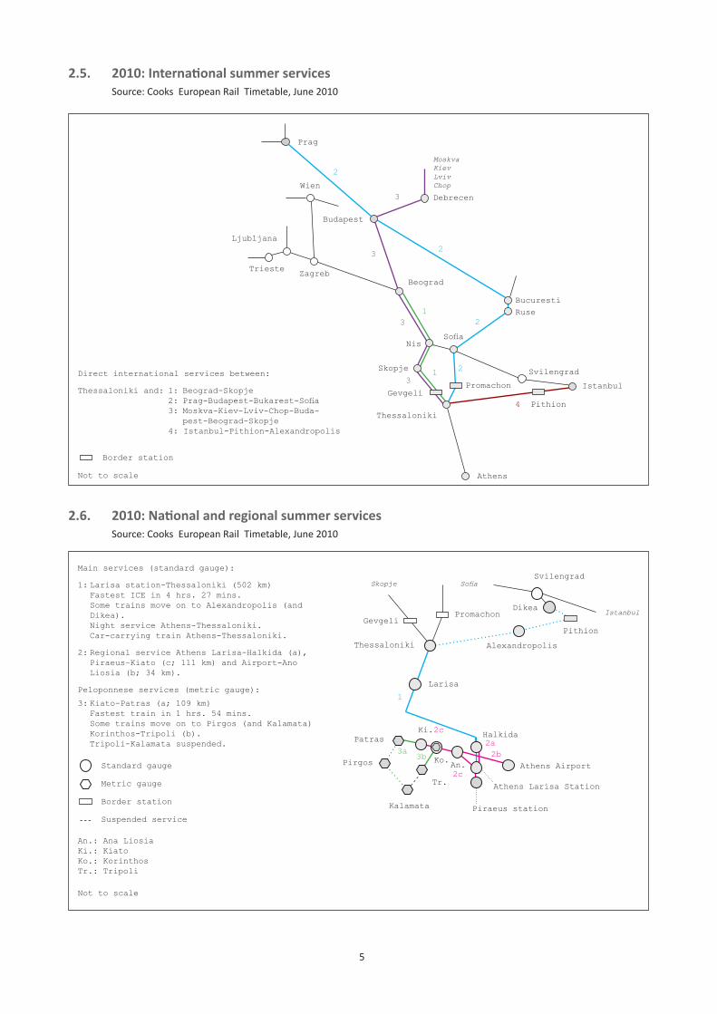
5
2.5. 2010:Internationalsummerservices Source: Cooks European Rail Timetable, June 2010
2.6. 2010:Nationalandregionalsummerservices Source: Cooks European Rail Timetable, June 2010
Budapest
Trieste
Ljubljana
ZagrebBeograd
Bucuresti
SofiaNis
Skopje
Thessaloniki
Svilengrad
Istanbul
Athens
Ruse
PromachonGevgeli
Direct international services between:
Thessaloniki and: 1: Beograd-Skopje 2:Prag-Budapest-Bukarest-Sofia 3: Moskva-Kiev-Lviv-Chop-Buda- pest-Beograd-Skopje 4: Istanbul-Pithion-Alexandropolis
Wien
Prag
21
2
2
Border station
Not to scale
1
Debrecen
MoskvaKievLvivChop
2
3
3
3
3
Promachon
Thessaloniki
Svilengrad
Alexandropolis
Larisa
Patras
Pirgos
Kalamata
GevgeliPithion
Sofia
Not to scale
Border station
Standard gauge
Metric gauge
Main services (standard gauge):
1: Larisa station-Thessaloniki (502 km) Fastest ICE in 4 hrs. 27 mins. Some trains move on to Alexandropolis (and
Dikea). Night service Athens-Thessaloniki. Car-carrying train Athens-Thessaloniki.
2: Regional service Athens Larisa-Halkida (a), Piraeus–Kiato (c; 111 km) and Airport-Ano
Liosia (b; 34 km).
Peloponnese services (metric gauge):
3: Kiato-Patras (a; 109 km) Fastest train in 1 hrs. 54 mins. Some trains move on to Pirgos (and Kalamata) Korinthos-Tripoli (b). Tripoli-Kalamata suspended.
1
Istanbul
3aKo.
An.: Ana LiosiaKi.: KiatoKo.: KorinthosTr.: Tripoli
2a
Skopje
Athens Larisa Station
Ki.
Athens AirportAn.
Halkida
2c
2b
2c
Suspended service
4
Dikea
Pithion
Tr.
3b
Piraeus station
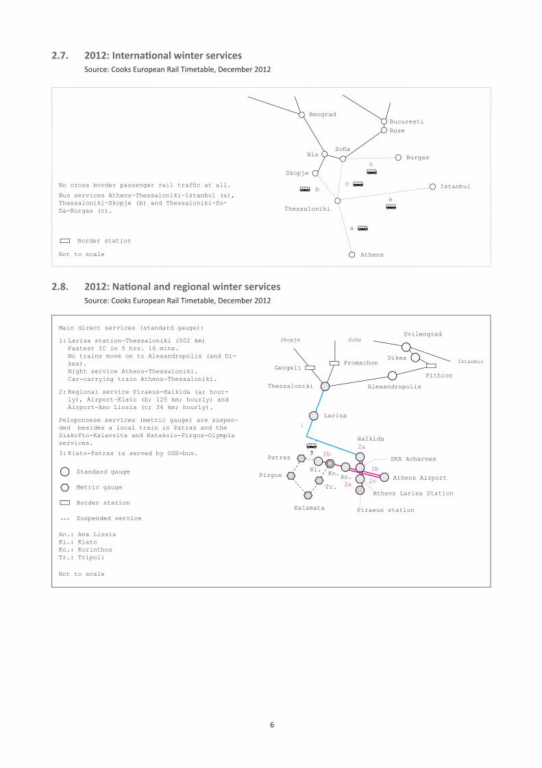
6
2.7. 2012:Internationalwinterservices Source: Cooks European Rail Timetable, December 2012
2.8. 2012:Nationalandregionalwinterservices Source: Cooks European Rail Timetable, December 2012
BeogradBucuresti
SofiaNis
Skopje
Thessaloniki
Istanbul
Athens
Ruse
Nocrossborderpassengerrailtrafficatall.
Bus services Athens-Thessaloniki-Istanbul (a), Thessaloniki-Skopje (b) and Thessaloniki-So-fia-Burgas(c).
Border station
Not to scale
Burgas
a
a
b
c
c
Promachon
Thessaloniki
Svilengrad
Alexandropolis
Larisa
Patras
Pirgos
Kalamata
GevgeliPithion
Sofi a
Not to scale
Border station
Standard gauge
Metric gauge
Main direct services (standard gauge):
1: Larisa station-Thessaloniki (502 km) Fastest IC in 5 hrs. 16 mins. No trains move on to Alexandropolis (and Di-
kea). Night service Athens-Thessaloniki. Car-carrying train Athens-Thessaloniki.
2: Regional service Piraeus-Halkida (a; hour-ly), Airport–Kiato (b; 125 km; hourly) and Airport-Ano Liosia (c; 34 km; hourly).
Peloponnese services (metric gauge) are suspen-ded besides a local train in Patras and the Diakofto-Kalavrita and Katakolo-Pirgos-Olympia services.
3: Kiato-Patras is served by OSE-bus.
1
Istanbul
Ko.
An.: Ana LiosiaKi.: KiatoKo.: KorinthosTr.: Tripoli
2a
Skopje
Athens Larisa Station
Ki.Athens AirportAn.
Halkida
2c
2b
Suspended service
Dikea
Tr.
3
Piraeus station
3SKA Acharnes
2a
2b
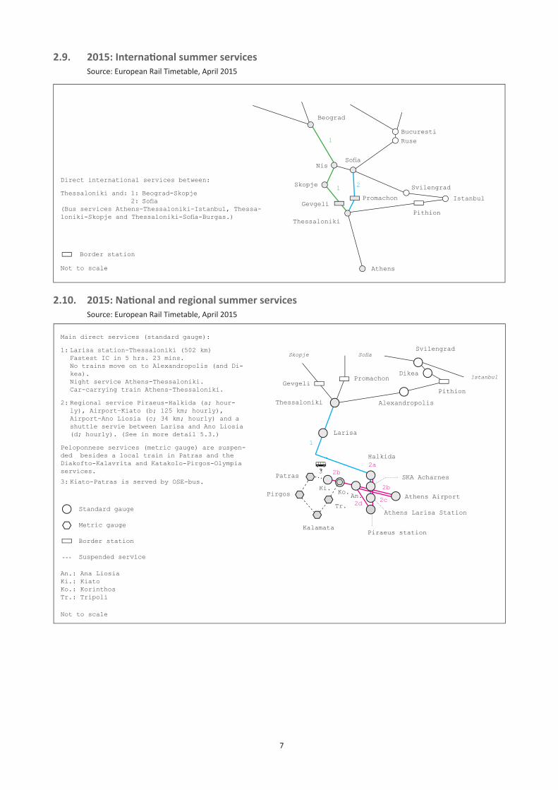
7
2.9. 2015:Internationalsummerservices Source: European Rail Timetable, April 2015
2.10. 2015:Nationalandregionalsummerservices Source: European Rail Timetable, April 2015
Beograd
Bucuresti
SofiaNis
Skopje
Thessaloniki
Svilengrad
Istanbul
Athens
Ruse
PromachonGevgeli
Direct international services between:
Thessaloniki and: 1: Beograd-Skopje 2:Sofia(Bus services Athens-Thessaloniki-Istanbul, Thessa-loniki-SkopjeandThessaloniki-Sofia-Burgas.)
1
2
Border station
Not to scale
1
Pithion
Promachon
Thessaloniki
Svilengrad
Alexandropolis
Larisa
Patras
Pirgos
Kalamata
GevgeliPithion
Sofi a
Not to scale
Border station
Standard gauge
Metric gauge
Main direct services (standard gauge):
1: Larisa station-Thessaloniki (502 km) Fastest IC in 5 hrs. 23 mins. No trains move on to Alexandropolis (and Di-
kea). Night service Athens-Thessaloniki. Car-carrying train Athens-Thessaloniki.
2: Regional service Piraeus-Halkida (a; hour-ly), Airport–Kiato (b; 125 km; hourly), Airport-Ano Liosia (c; 34 km; hourly) and a shuttle servie between Larisa and Ano Liosia (d; hourly). (See in more detail 5.3.)
Peloponnese services (metric gauge) are suspen-ded besides a local train in Patras and the Diakofto-Kalavrita and Katakolo-Pirgos-Olympia services.
3: Kiato-Patras is served by OSE-bus.
1
Istanbul
Ko.
An.: Ana LiosiaKi.: KiatoKo.: KorinthosTr.: Tripoli
2a
Skopje
Athens Larisa Station
Ki.Athens AirportAn.
Halkida
2c
2b
Suspended service
Dikea
Tr.
3
Piraeus station
3SKA Acharnes
2d
2b
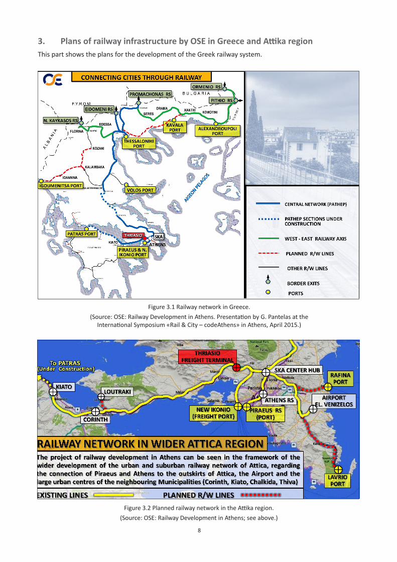
8
3. PlansofrailwayinfrastructurebyOSEinGreeceandAttikaregionThis part shows the plans for the development of the Greek railway system.
Figure 3.1 Railway network in Greece. (Source: OSE: Railway Development in Athens. Presentation by G. Pantelas at the
International Symposium «Rail & City – codeAthens» in Athens, April 2015.)
Figure 3.2 Planned railway network in the Attika region. (Source: OSE: Railway Development in Athens; see above.)
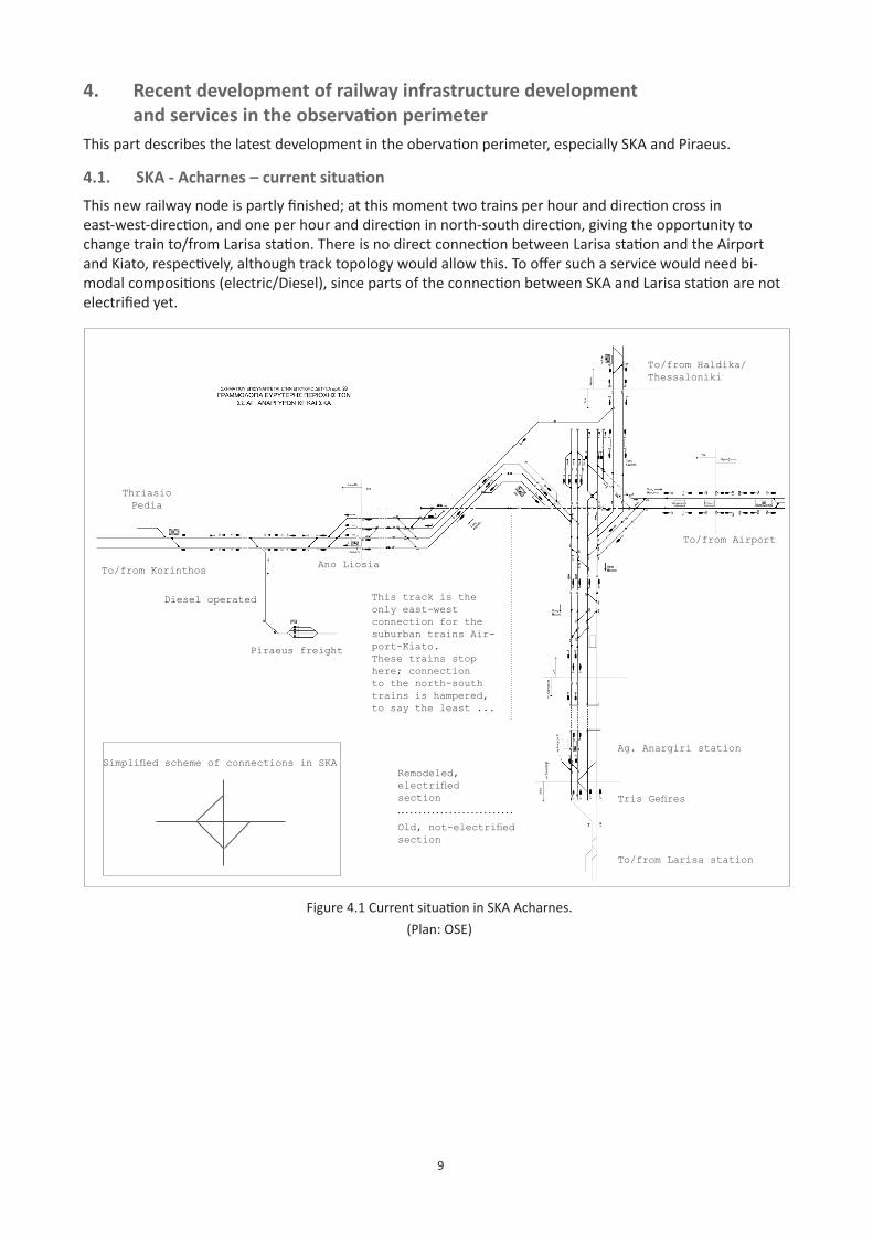
9
4. Recent development of railway infrastructure development andservicesintheobservationperimeterThis part describes the latest development in the obervation perimeter, especially SKA and Piraeus.
4.1. SKA-Acharnes–currentsituationThis new railway node is partly finished; at this moment two trains per hour and direction cross in east-west-direction, and one per hour and direction in north-south direction, giving the opportunity to change train to/from Larisa station. There is no direct connection between Larisa station and the Airport and Kiato, respectively, although track topology would allow this. To offer such a service would need bi-modal compositions (electric/Diesel), since parts of the connection between SKA and Larisa station are not electrified yet.
Figure 4.1 Current situation in SKA Acharnes.(Plan: OSE)
To/from Larisa station
TrisGefires
Ag. Anargiri station
To/from Airport
To/from Korinthos
To/from Haldika/Thessaloniki
This track is the only east-west connection for the suburban trains Air-port-Kiato.These trains stop here; connection to the north-south trains is hampered, to say the least ...
Remodeled, electrifiedsection
Old,not-electrifiedsection
SimplifiedschemeofconnectionsinSKA
Ano Liosia
Thriasio Pedia
Piraeus freight
Diesel operated
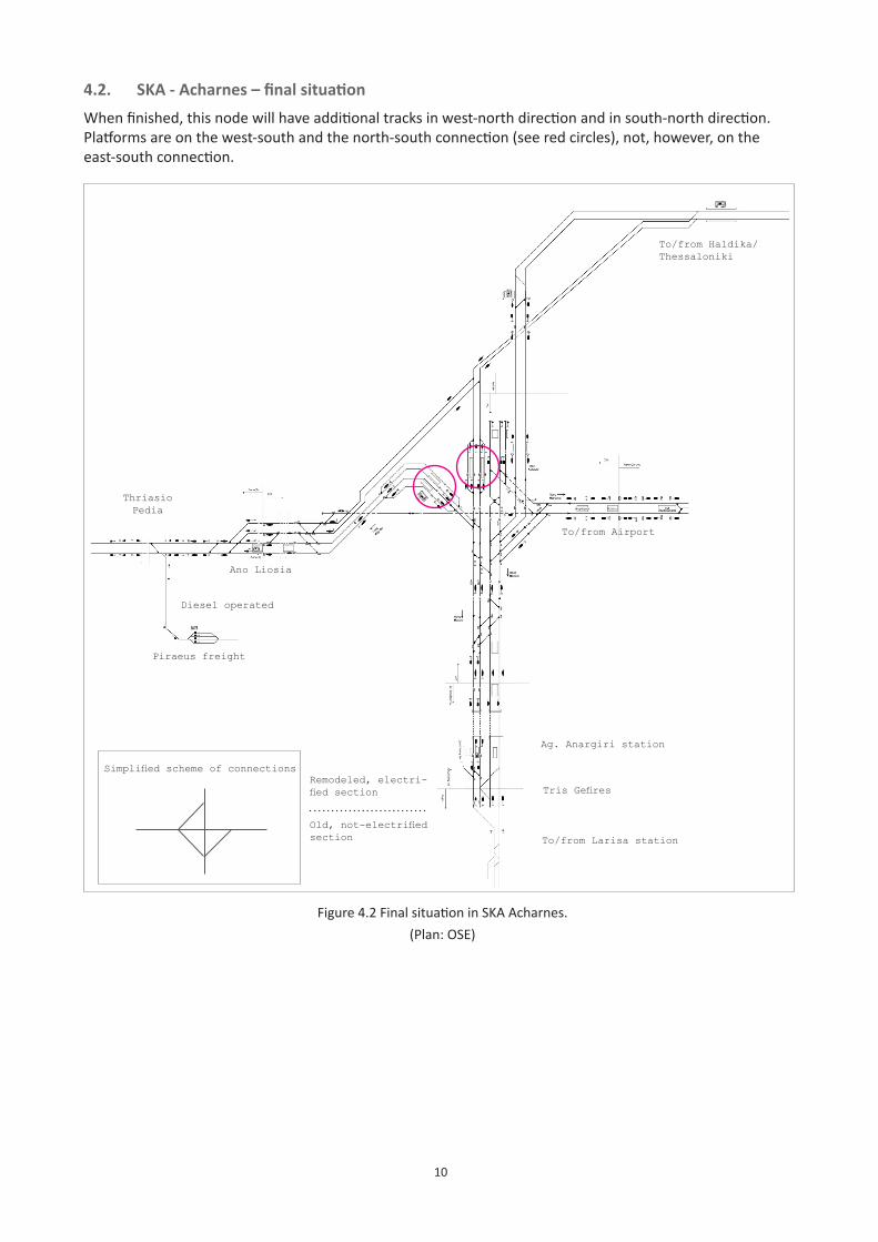
10
To/from Larisa station
TrisGefires
Ag. Anargiri station
To/from Airport
To/from Haldika/Thessaloniki
Remodeled, electri-fiedsection
Old,not-electrifiedsection
Simplifiedschemeofconnections
4.2. SKA-Acharnes–finalsituationWhen finished, this node will have additional tracks in west-north direction and in south-north direction. Platforms are on the west-south and the north-south connection (see red circles), not, however, on the east-south connection.
Figure 4.2 Final situation in SKA Acharnes.(Plan: OSE)
Ano Liosia
Thriasio Pedia
Piraeus freight
Diesel operated
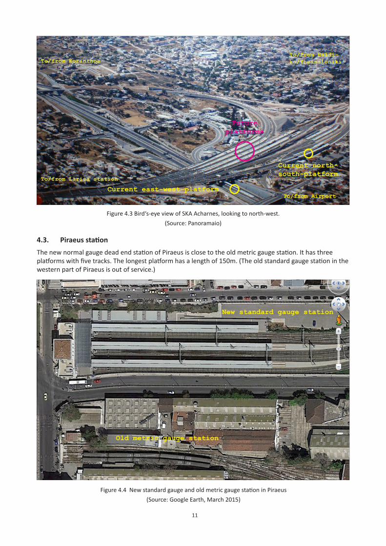
11
Figure 4.3 Bird‘s-eye view of SKA Acharnes, looking to north-west.(Source: Panoramaio)
To/from Larisa station
To/from Korinthos
To/from Airport
To/from Haldi-ka/Thessaloniki
Current east-west-platform
Current north-south-platform
Futureplatforms
4.3. PiraeusstationThe new normal gauge dead end station of Piraeus is close to the old metric gauge station. It has three platforms with five tracks. The longest platform has a length of 150m. (The old standard gauge station in the western part of Piraeus is out of service.)
Figure 4.4 New standard gauge and old metric gauge station in Piraeus(Source: Google Earth, March 2015)
New standard gauge station
Old metric gauge station
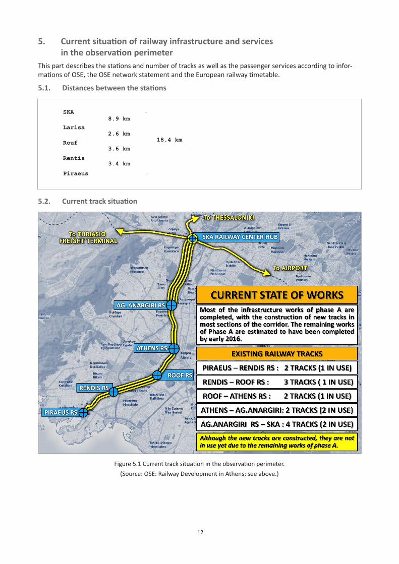
12
5. Currentsituationofrailwayinfrastructureandservices intheobservationperimeterThis part describes the stations and number of tracks as well as the passenger services according to infor-mations of OSE, the OSE network statement and the European railway timetable.
5.1. Distancesbetweenthestations
Figure 5.1 Current track situation in the observation perimeter.(Source: OSE: Railway Development in Athens; see above.)
5.2. Currenttracksituation
SKA
Larisa
Rouf
Rentis
Piraeus
8.9 km
2.6 km
3.6 km
3.4 km
18.4 km
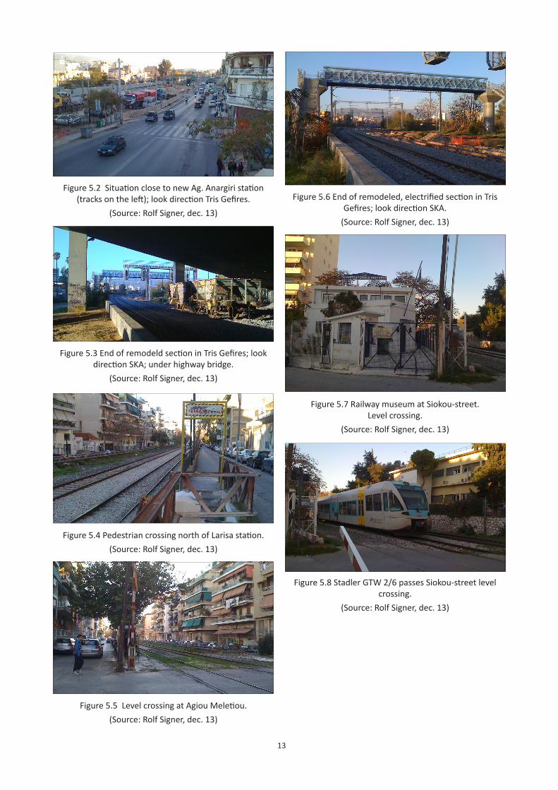
13
Figure 5.2 Situation close to new Ag. Anargiri station (tracks on the left); look direction Tris Gefires.
(Source: Rolf Signer, dec. 13)
Figure 5.6 End of remodeled, electrified section in Tris Gefires; look direction SKA.
(Source: Rolf Signer, dec. 13)
Figure 5.3 End of remodeld section in Tris Gefires; look direction SKA; under highway bridge.
(Source: Rolf Signer, dec. 13)
Figure 5.7 Railway museum at Siokou-street. Level crossing.
(Source: Rolf Signer, dec. 13)
Figure 5.8 Stadler GTW 2/6 passes Siokou-street level crossing.
(Source: Rolf Signer, dec. 13)
Figure 5.4 Pedestrian crossing north of Larisa station.(Source: Rolf Signer, dec. 13)
Figure 5.5 Level crossing at Agiou Meletiou.(Source: Rolf Signer, dec. 13)
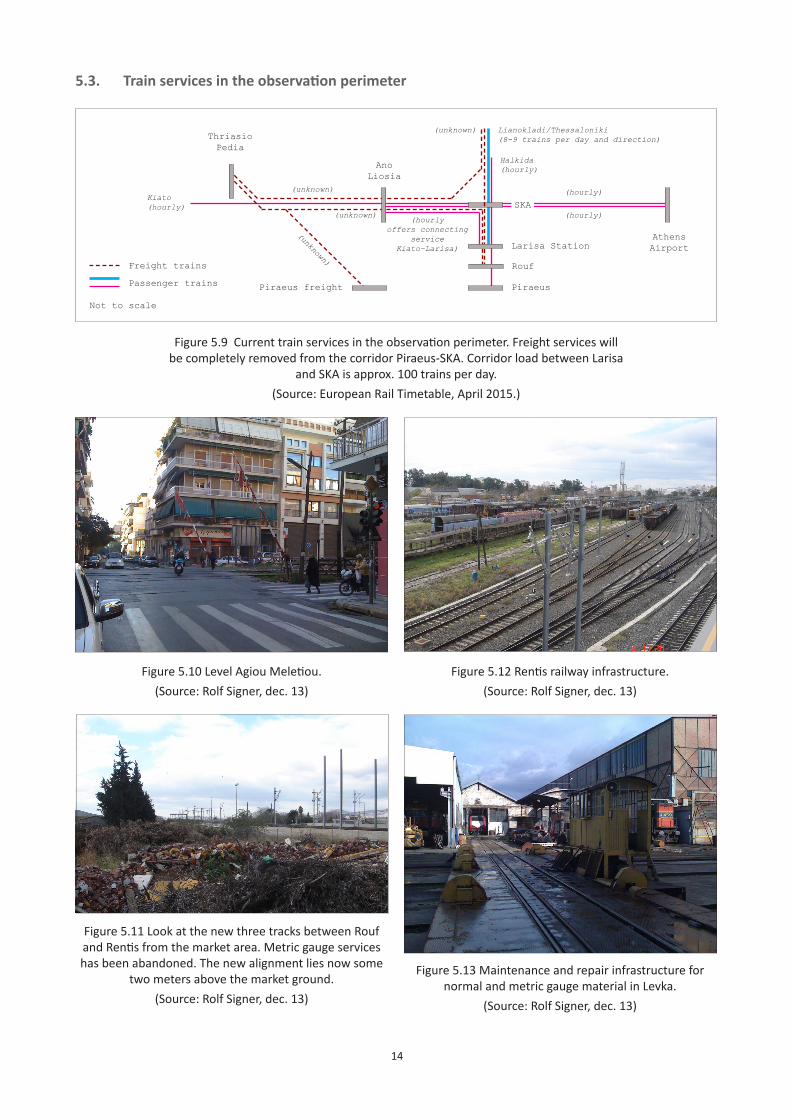
14
5.3. Trainservicesintheobservationperimeter
Athens Airport
Not to scale
Ano Liosia
SKA
Larisa Station
Piraeus
Lianokladi/Thessaloniki(8-9 trains per day and direction)
Halkida(hourly)
Kiato(hourly)
(hourly)(hourly
offers connecting service
Kiato-Larisa)
Figure 5.9 Current train services in the observation perimeter. Freight services will be completely removed from the corridor Piraeus-SKA. Corridor load between Larisa
and SKA is approx. 100 trains per day. (Source: European Rail Timetable, April 2015.)
Figure 5.10 Level Agiou Meletiou.(Source: Rolf Signer, dec. 13)
Figure 5.12 Rentis railway infrastructure.(Source: Rolf Signer, dec. 13)
Figure 5.11 Look at the new three tracks between Rouf and Rentis from the market area. Metric gauge services has been abandoned. The new alignment lies now some
two meters above the market ground.(Source: Rolf Signer, dec. 13)
Figure 5.13 Maintenance and repair infrastructure for normal and metric gauge material in Levka.
(Source: Rolf Signer, dec. 13)
Passenger trains
Freight trains Rouf
Piraeus freight
Thriasio Pedia
(unknown)
(unknown)
(unknown)
(hourly)(unknown)
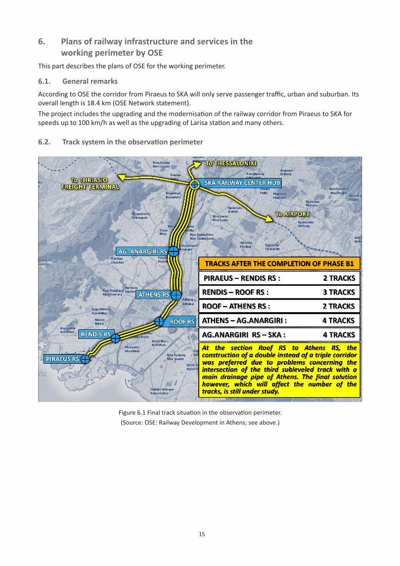
15
6. Plans of railway infrastructure and services in the workingperimeterbyOSEThis part describes the plans of OSE for the working perimeter.
6.1. GeneralremarksAccording to OSE the corridor from Piraeus to SKA will only serve passenger traffic, urban and suburban. Its overall length is 18.4 km (OSE Network statement).The project includes the upgrading and the modernisation of the railway corridor from Piraeus to SKA for speeds up to 100 km/h as well as the upgrading of Larisa station and many others.
6.2. Tracksystemintheobservationperimeter
Figure 6.1 Final track situation in the observation perimeter.(Source: OSE: Railway Development in Athens; see above.)
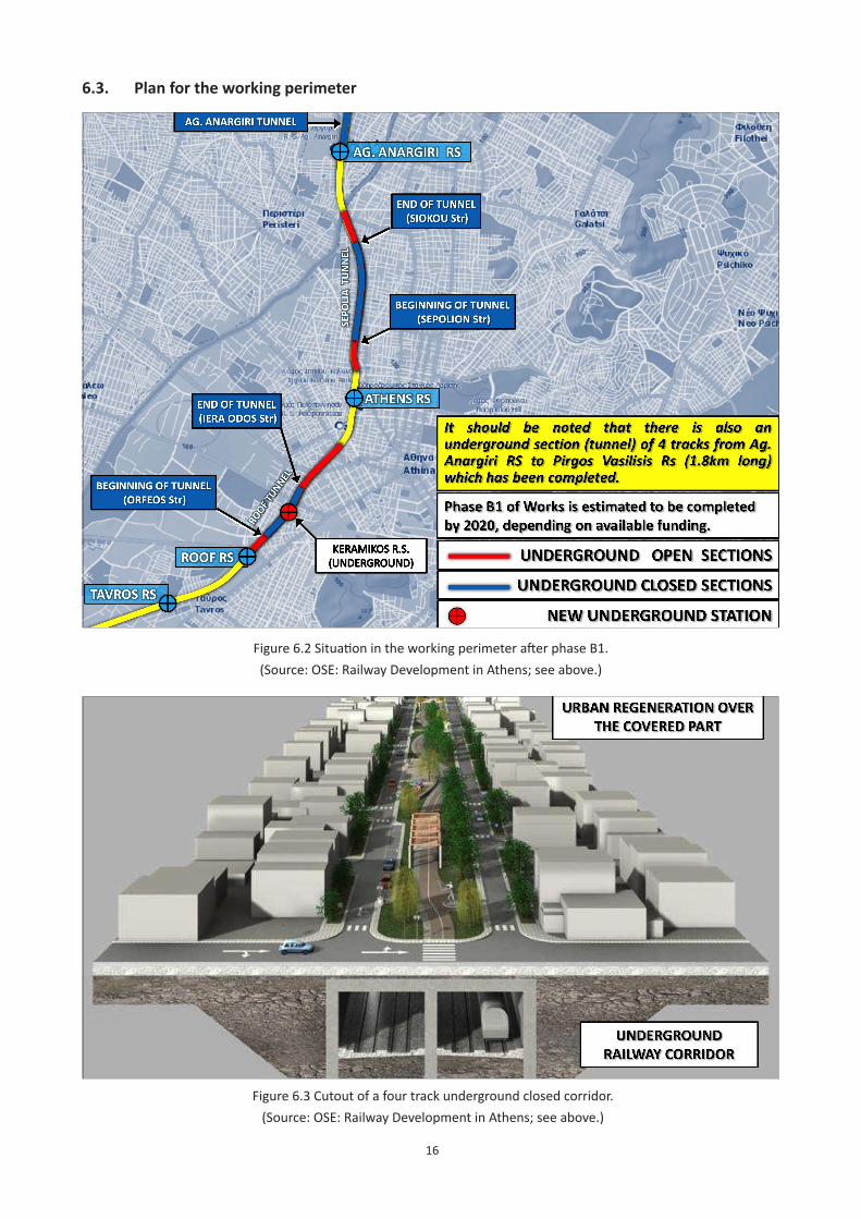
16
6.3. Planfortheworkingperimeter
Figure 6.2 Situation in the working perimeter after phase B1.(Source: OSE: Railway Development in Athens; see above.)
Figure 6.3 Cutout of a four track underground closed corridor.(Source: OSE: Railway Development in Athens; see above.)
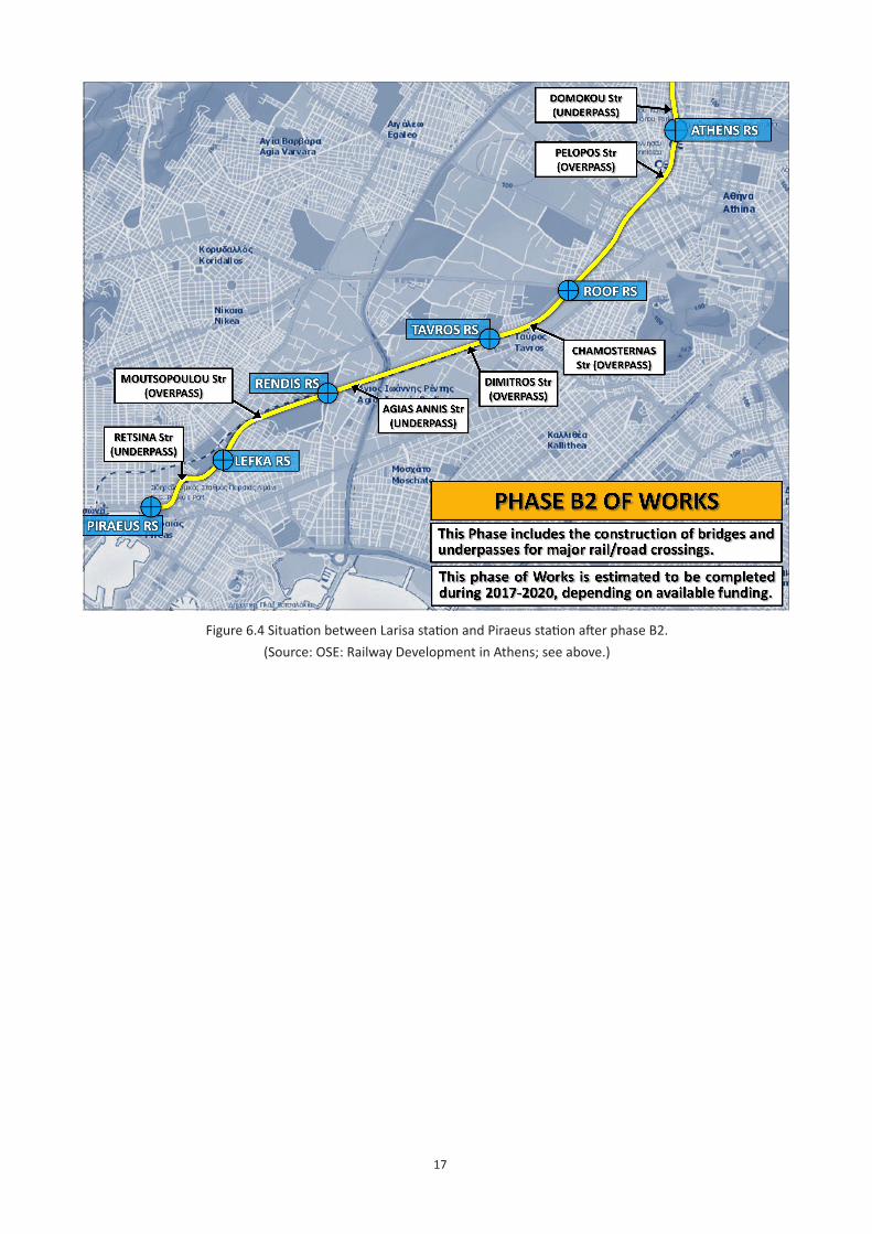
17
Figure 6.4 Situation between Larisa station and Piraeus station after phase B2.(Source: OSE: Railway Development in Athens; see above.)
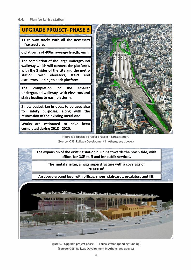
18
6.4. PlanforLarisastation
Figure 6.6 Upgrade project phase C – Larisa station (pending funding).(Source: OSE: Railway Development in Athens; see above.)
Figure 6.5 Upgrade project phase B – Larisa station.(Source: OSE: Railway Development in Athens; see above.)
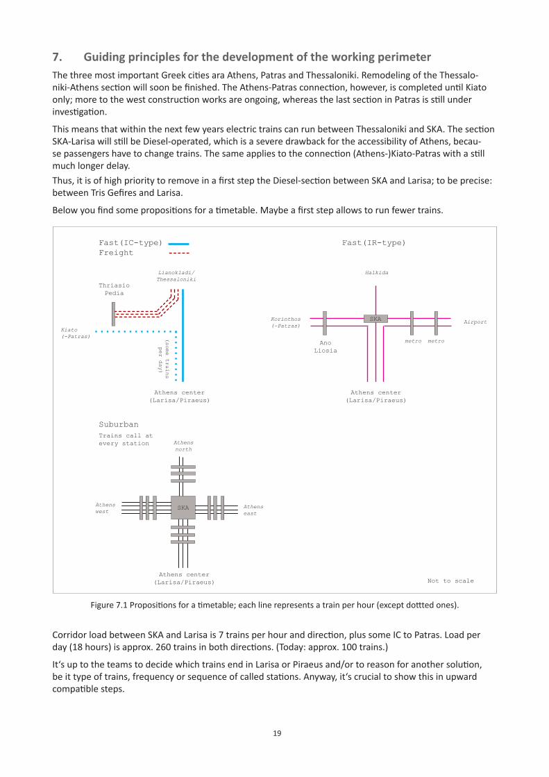
19
7. GuidingprinciplesforthedevelopmentoftheworkingperimeterThe three most important Greek cities ara Athens, Patras and Thessaloniki. Remodeling of the Thessalo-niki-Athens section will soon be finished. The Athens-Patras connection, however, is completed until Kiato only; more to the west construction works are ongoing, whereas the last section in Patras is still under investigation.
This means that within the next few years electric trains can run between Thessaloniki and SKA. The section SKA-Larisa will still be Diesel-operated, which is a severe drawback for the accessibility of Athens, becau-se passengers have to change trains. The same applies to the connection (Athens-)Kiato-Patras with a still much longer delay.Thus, it is of high priority to remove in a first step the Diesel-section between SKA and Larisa; to be precise: between Tris Gefires and Larisa.
Below you find some propositions for a timetable. Maybe a first step allows to run fewer trains.
Fast(IC-type)Freight
Athens center(Larisa/Piraeus)
Kiato (-Patras)
Lianokladi/Thessaloniki
Fast(IR-type)
metro metro
AirportKorinthos (-Patras)
Ano Liosia
Halkida
Thriasio Pedia
Athens center(Larisa/Piraeus)
Not to scale
Suburban
Athens north
Athens east
Athens center(Larisa/Piraeus)
(some trains
per day)
Trains call at every station
SKA
Figure 7.1 Propositions for a timetable; each line represents a train per hour (except dottted ones).
Corridor load between SKA and Larisa is 7 trains per hour and direction, plus some IC to Patras. Load per day (18 hours) is approx. 260 trains in both directions. (Today: approx. 100 trains.)
It‘s up to the teams to decide which trains end in Larisa or Piraeus and/or to reason for another solution, be it type of trains, frequency or sequence of called stations. Anyway, it‘s crucial to show this in upward compatible steps.
SKAAthens west
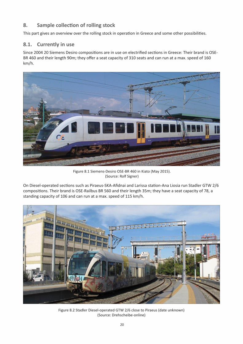
20
8. SamplecollectionofrollingstockThis part gives an overview over the rolling stock in operation in Greece and some other possibilities.
8.1. Currently in useSince 2004 20 Siemens Desiro compositions are in use on electrified sections in Greece: Their brand is OSE-BR 460 and their length 90m; they offer a seat capacity of 310 seats and can run at a max. speed of 160 km/h.
Figure 8.1 Siemens-Desiro OSE-BR 460 in Kiato (May 2015).(Source: Rolf Signer)
On Diesel-operated sections such as Piraeus-SKA-Afidnai and Larissa station-Ana Liosia run Stadler GTW 2/6 compositions. Their brand is OSE-Railbus BR 560 and their length 35m; they have a seat capacity of 78, a standing capacity of 106 and can run at a max. speed of 115 km/h.
Figure 8.2 Stadler Diesel-operated GTW 2/6 close to Piraeus (date unknown)(Source: Drehscheibe-online)
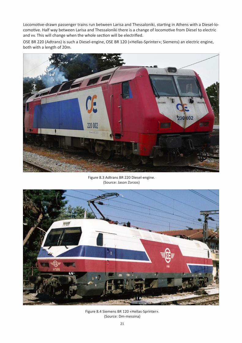
21
Locomotive-drawn passenger trains run between Larisa and Thessaloniki, starting in Athens with a Diesel-lo-comotive. Half way between Larisa and Thessaloniki there is a change of locomotive from Diesel to electric and vv. This will change when the whole section will be electrified.OSE BR 220 (Adtrans) is such a Diesel-engine, OSE BR 120 («Hellas-Sprinter»; Siemens) an electric engine, both with a length of 20m.
Figure 8.3 Adtrans BR 220 Diesel-engine.(Source: Jason Zorzos)
Figure 8.4 Siemens BR 120 «Hellas-Sprinter».(Source: Dm-messina)
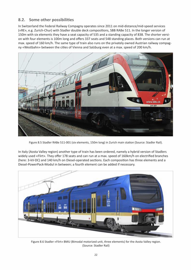
22
8.2. SomeotherpossibilitiesIn Switzerland the Federal Railway Compagny operates since 2011 on mid-distance/mid-speed services («RE», e.g. Zurich-Chur) with Stadler double deck compositions, SBB RABe 511. In the longer version of 150m with six elements they have a seat capacity of 535 and a standing capacity of 838. The shorter versi-on with four elements is 100m long and offers 337 seats and 548 standing places. Both versions can run at max. speed of 160 km/h. The same type of train also runs on the privately owned Austrian railway compag-ny «Westbahn» between the cities of Vienna and Salzburg even at a max. speed of 200 km/h.
Figure 8.5 Stadler RABe 511-001 (six elements, 150m long) in Zurich main station (Source: Stadler Rail).
In Italy (Aosta Valley region) another type of train has been ordered, namely a hybrid version of Stadlers widely used «Flirt». They offer 178 seats and can run at a max. speed of 160km/h on electrified branches (here: 3-kV-DC) and 140 km/h on Diesel-operated sections. Each composition has three elements and a Diesel-PowerPack-Modul in between; a fourth element can be added if necessary.
Figure 8.6 Stadler «Flirt» BMU (Bimodal motorized unit, three elements) for the Aosta Valley region.(Source: Stadler Rail)
