country activities - 一般財団法人リモート・セン … activities kusuma, msb, et.al....
TRANSCRIPT

GEOSS Asian Water Cycle Initiative Country Activities
Kusuma, MSB, et.al. Water Res Eng, FCEE, ITB

Kusuma, MSB, et.al, Water Res Eng, FCEE, ITB
INDONESIA
Study Area : Citarum River
2
Citarum River Basin,West Java. Indonesia
Lower Citarum

Kusuma, MSB, et.al, Water Res Eng, FCEE, ITB
INDONESIA
Citarum Frame Work
3
VISION Collaboration between government and the
community to have a clean, healthy, productive, and sustainable
Main Pillars
Foundation
Community Empowerment Data & Information
Institu-tional and IWRM Planning
Water Resour-ces Develop-ment
Water Use and
Allocation
Enviro-mental Protec-tion
Disaster Preven-tion
Source: citarum.org

Kusuma, MSB, et.al, Water Res Eng, FCEE, ITB
INDONESIA
Existing Problem Floods : upstream (Bandung City) and downstream area
(Kerawang etc)
Drought : Upstrean and Downstream
Water quality : Three cascade reservoir, Upstream (Bandung) and downstream (Kerawang etc).
Water allocation : constraint/conflict among three cascade reservoir with different purposes priority (Hydropower, irrigation and raw water for industry/housing). Water pricing issue.
Lack of data and reliable analitycal method.
Influences of landuse changes and climate changes to the above problem
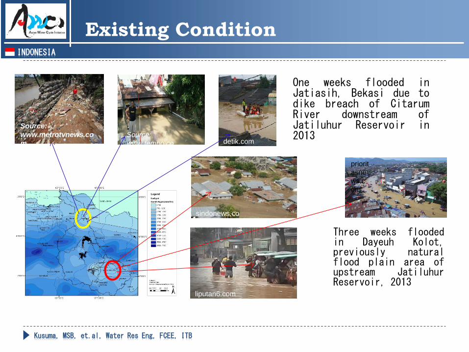
Existing Condition
Kusuma, MSB, et.al, Water Res Eng, FCEE, ITB
INDONESIA
Three weeks flooded in Dayeuh Kolot, previously natural flood plain area of upstream Jatiluhur Reservoir, 2013
sindonews.com
liputan6.com
prioritasnews.com
Existing Condition
detik.com Source: www.tempo.co
Source: www.metrotvnews.com
One weeks flooded in Jatiasih, Bekasi due to dike breach of Citarum River downstream of Jatiluhur Reservoir in 2013

Kusuma, MSB, et.al, Water Res Eng, FCEE, ITB
INDONESIA
Engineering solution is only a short term as there is socio engineering solution required for the following problem :
Erosion and sedimentation
Solid waste
Land use change
Water suply/allocation
Existing Condition
1986 Before normalization 1994 Partial normalization 2001 Nearly final normalization 2003 Final normalization
2005 After normalization
2010 After normalization

Kusuma, MSB, et.al, Water Res Eng, FCEE, ITB
INDONESIA
Three Cascade Reservoir of Citarum River (Flood, Irrigation, Power, Raw Water and Aqua Culture)
Saguling,1984, IndoPower Cirata (1988, PT PJB) Jatiluhur 1967, POJ
Jatiluhur Dam during drougt event in 2013, Source: voaindonesia.com
Jatiluhur Dam during flood event in 2010, Source: nasional.news.viva.co.id
Existing Condition
Average annual sedimentation rate 8 million m3/year flood in rainy
season and water scarcity in the dry season (ASER 2008, BPLHD)

Kusuma, MSB, et.al, Water Res Eng, FCEE, ITB
INDONESIA
Existing Condition
555 000 m3/year of solid waste (BBWSC, 2013), Batujajar Bridge - Photo: The Sun, 2009
190 Tons /day of organic Waste, BPLHD,2009
Watershed degradation in neglasari area (BBWSC, 2013)
Industrial and domestic waste, upstream and downstream, BBWSC, 2013
Ciwidey, upstream area, MSB Kusuma, 2005

Kusuma, MSB, et.al, Water Res Eng, FCEE, ITB
INDONESIA
White paper of Climate Chang Adaptation Scenario (Koike T, Univ of Tokyo, AWCI, Nov 2010)
Flood
Population
Growth
Urbanization
Three Cascades
Reservoir Operations Poverty
Organic Waste
Solid Waste
Subsidence
Ground Water Exploitation
Energy
Spatial
Planning
Problems
Food Production
Land Use
Change
Governance
many agencies
Fisheries
Watershed Degradation
Water
Demand Sedimentation
Water
Pollution
Inconsistency of Infrastructure
Characteristics of Water-Nexus in the Citarum River Basin (Koike T et al, WS, Bandung, 26J2013)
Key Changes Consequences
Runoff Ratio
Climate Change
Fertilizer

Kusuma, MSB, et.al, Water Res Eng, FCEE, ITB
INDONESIA
Project Design Matrix : Outline
Project Purpose:
Adaptation of water resources management system in Citarum River Basin based
on evaluation of land use and climate change impact to flood and drought, by using improved datasets and analytical methodology
Expected Outputs: Update hydrological data and analysis method to identify flood and
drought trend
Demonstrate climate change impacts on floods and droughts based on the updated data and analysis method
Improvement the use of observational data and modeling to develop water resources management strategies in the future and its application capacity
Potential Activities and Collaboration: Updating observation data of rainfall, climatology, river discharge, and
land cover and analysis method for flood and drought assessment
Disseminating water resources management strategies, data sharing and technology among institutions

Kusuma, MSB, et.al, Water Res Eng, FCEE, ITB
INDONESIA
Project Design Matrix : Expected Outputs
Update hydrological data and analysis method to identify flood and drought trend in Citarum River Basin Updated observation data of rainfall, climatology, river discharge, and land cover in
Citarum River Basin
Updated analysis method for flood and drought assessment
Demonstrate climate change impacts on floods and droughts based on the updated data and analysis method Updated flood and drought assessment through implementing of bias correction and
statistical downscaling of the selected GCMs
To develop near-real time rainfall-run off data observation/assessment and data dissemination systems based on ground data and satellite coupling which would be used as inputs into flood and drought prediction
To develop comprehensive climate observation data archives including land cover satellite image which are used for climate and land cover change analysis
Improvement the use of observational data and modeling to develop water resources management strategies in the future and its application capacity Improvement the appropriate unit hydrograph method and drought indices for
flood/drought assessment in Citarum River Basin / Indonesia
Dissemination of water resources management strategies, data sharing and technology among institutions
Improvement of the curriculum for undergraduate program in the topics of water resources engineering and management, sub-topics of flood and drought assessment

Kusuma, MSB, et.al, Water Res Eng, FCEE, ITB
INDONESIA
Project Design Matrix : Activities Plan
Potential activities and collaboration Updating hydrological and analysis method to identify flood and drought trend in Citarum River Basin Updating observation data of rainfall, climatology, river
discharge, and land cover in Citarum River Basin Updating analysis method for flood and drought assessment Expected collaborators:
Ministry of Public Work : Puslitbang SDA (Research Centre for Water Resources), BBWSC (Citarum River Basin Organization) and PJT-II (Jatiluhur Dam Authority)
BMKG (Indonesian Agency for Meteorology, Climatology and Geophysics),
Local Government : BPLHD and Dinas PSDA Jawa Barat (West Java Water Resources Development Agency)
LAPAN (National Institute of Aeronautic and Space of Indonesia)
Directorate General of Higher Education (DIKTI)
MP3EI (Masterplan for Acceleration and Expansion of Economic Development, Coordinating Ministry of Economic Affairs)
AWCI (Asian Water Cycle Initiative) and Tokyo University (DIAS : Data Integration and Analysis System)
GEOSS (Global Earth Observation System of Systems)

Kusuma, MSB, et.al, Water Res Eng, FCEE, ITB
INDONESIA
Project Design Matrix : Activities Plan
Demonstrating climate change impacts on floods and droughts based on the updated data and analysis method Updating flood and drought assessment through implementing of bias
correction and statistical downscaling of the selected GCMs
Developing near-real time rainfall-run off data observation/assessment and data dissemination systems based on ground data and satellite coupling which would be used as inputs into flood and drought prediction
Developing comprehensive climate observation data archives including land cover satellite image which are used for climate and land cover change analysis
Expected collaborators: Ministry of Public Work : Puslitbang SDA (Research Centre for Water Resources), BBWSC
(Citarum River Basin Organization) and PJT-II (Jatiluhur Dam Authority)
BMKG (Indonesian Agency for Meteorology, Climatology and Geophysics)
AWCI (Asian Water Cycle Initiative), DIAS (Data Integration and Analysis System) and University of Tokyo
LAPAN (National Institute of Aeronautic and Space of Indonesia)
GEOSS (Global Earth Observation System of Systems)

Kusuma, MSB, et.al, Water Res Eng, FCEE, ITB
INDONESIA
Project Design Matrix : Activities Plan
Improving the use of observational data and modeling to develop water resources management strategies in the future and its application capacity
Improving the appropriate unit hydrograph method and drought indices for flood/drought assessment in Citarum River Basin / Indonesia
Disseminating water resources management strategies, data sharing and technology among institutions
Improving the curriculum for undergraduate program in the topics of water resources engineering and management, sub-topics of flood and drought assessment
Expected collaborators: Ministry of Public Work : Puslitbang SDA (Research Centre for Water Resources),
BBWSC (Citarum River Basin Organization) and PJT-II (Jatiluhur Dam Authority)
BAPPENAS (State Ministry of National Development Planning)
BMKG (Indonesian Agency for Meteorology, Climatology and Geophysics)
Local Government
LAPAN (National Institute of Aeronautic and Space of Indonesia)
Directorate General of Higher Education (DIKTI)
AWCI (Asian Water Cycle Initiative), DIAS (Data Integration and Analysis System) and University of Tokyo

Kusuma, MSB, et.al, Water Res Eng, FCEE, ITB
INDONESIA
Indonesian Universities and Research Institution Join research on particular themes Private Sector
Involvement
Climate Variability Climate Change
Global
Regional
Local
Water Related Impacts
Drought Flood Other Impacts Research
People Awareness
Mitigation Plan
Implementation
Local Level Policy
AWCI, Tokyo/ Japanese University and Other Institution Downscaling of climatology data and scenarios
BBWSC, PJT-II,
DPSDA, etc Data,
Implementation and Policy BAPPENAS,
BAPPEDA Join research on particular themes
Collaboration Opportunities
International/National Funding Institution Program Cooperation
Curent Presentation

Kusuma, MSB, et.al, Water Res Eng, FCEE, ITB
INDONESIA
Project Design Matrix : Progress
Activities : Research : Improvement of data base and assessment method
Education : Improvement of curriculum of water resources engineering study program
Training : Improvement of assessment tools
Community services : Contribution to problem solving of local people
Partners National and local level
Government
Private
Local people
Universities and research institution
Overseas level
Association//Group : GEOSS-ACWI
Universities : Tokyo University
Donor institution : APN (last proposal failed might be caused by missed one
cv of team member)

Kusuma, MSB, et.al, Water Res Eng, FCEE, ITB
INDONESIA
Project Design Matrix : Progress
Research : Study of Runoff Control Effect in Upper Citarum Watershed Rivers (Cisangkuy,
Citarik, Cikapundung) to South Bandung Flood
Evaluation of Water Resources Management System for Climate Change Adaptation
Spatial Model of Risk Analysis in Determining Flood Control Criteria (Case study: Upper Citarum River Basin), 2013
Training : Improvement of assessment tools
Community services : Contribution to problem solving of local people

Kusuma, MSB, et.al, Water Res Eng, FCEE, ITB
INDONESIA
Project Design Matrix : Progress
Rainfall
Discharg
Data observation ; varies from one station to another. From 376 rainfall stations, 26 stations (6.9% ) has very good data record with data availability more than 90%, 142 stations (37.8% ) have relatively good data records with data availability more than 70% and 192 stations (51.2%) have bad data records with data availability less than 50%.
Data Availability >90% (26stations)
Data Availability >70% (142 stations)
Data Availability <50% (192stations)
Meteorological Station at Lembang
Discharge Station at Cirasea-Cengkrong
Rainfall Station at Cicalengka Discharge Station at Nanjung

19
Trend of Climate Change Effect in the Pacific Ocean to Rainfall in Citarum
Correlation of MEI and monthly rainfall during dry season
Correlation of MEI and monthly rainfall during wet season
Trend: Upper Citarum tends to have a positive correlation coefficient, while lower Citarum tends to have a negative correlation coefficient. If MEI takes place in the dry season, upper Citarum tends to have more rainfall while lower Citarum tends to get less rainfall. If the warm phase of MEI takes place during rain season, both regions of upper Citarum and lower Citarum tend to have less rainfall, however, the potential of reduction in rainfall tends to be much in upper Citarum than in lower Citarum

20
Trend of Climate Change Effect in the Indian Ocean to Rainfall in Citarum
Correlation of DMI and monthly rainfall during dry season
Correlation of DMI and monthly rainfall during wet season
Trend: If warm phase of DMI takes place in dry season, then both regions of upper Citarum and lower Citarum tend to have less rainfall compared to the potential reduction which is much in lower Citarum than upper Citarum If warm phase of DMI takes place in rain season, rainfall in upper Citarum tends to be lower while rainfall in lower Citarum tends to be higher.

Kusuma, MSB, et.al, Water Res Eng, FCEE, ITB
INDONESIA
21
Climate Change: Rainfall and river discharge trend
Trend of increase in average rainfall and discharge during wet season, and decrease in dry season within the last few decades: (Case Study of Upper Citarum River Basin)
decrease
increase
decrease increase
Nanjung Station
Upper Citarum River Basin
Current and near future Activities

Kusuma, MSB, et.al, Water Res Eng, FCEE, ITB
INDONESIA
Current and near future Activities Community Services
22
Citarum Bestari (Clean, Healthy, Sustainable, Attractive) and Eco-village Project
Rapid development in Citarum River Basin has resulted in the degradation in its water quality. Ecosystem restoration need to be conducted through an integrated and systematic action by involving the relevant stakeholders. To support this program, the Government of West Java Province through launch ‘Citarum Bestari Action Plan’, particularly in the upstream of Citarum River Basin from km 0 to km 77.
Eco Village Program also launched to increase the awareness of the society to support Citarum River Ecosystem Restoration
Cikapundung
Cidurian
Citarum Hulu Cijalupang
Citarik Cikeruh
Cisangkuy Ciwidey
Cimahi
Saguling
Cisanti Lake, Upstream of Citarum River Basin

Kusuma, MSB, et.al, Water Res Eng, FCEE, ITB
INDONESIA
23
Efforts To Support Water Resources Management in Subang district: Case Studies Cipunegara
Flood and droughts risk be reduced by a well-integrated water resources management especially in managing water during the rainy and dry season. Subang District is one of the area in West Java Province with relatively high risk to flood and drought. In the early of 2014, thousand of houses were inundated during the flood event which hit 13 sub-district in Subang. In the other hand, large area of rice field in this district also susceptible to drought in dry season. This program focused on the flood and drought assessment in Cipunegara River Basin as one of the main river in Subang District.
www.tempo.com
Flood in Subang District, 2014
Community Services
Current and near future Activities

Kusuma, MSB, et.al, Water Res Eng, FCEE, ITB
INDONESIA Related Research and Academic Activities
24
Flood Assessment in PT. INTI Area
PT . INTI is a national telecommunication and electrical devices manufacture, founded in the early 1970. The factory site in Dayeuh Kolot, Bandung, is located in low contour and relatively close to Citarum River. The rapid development of industrial area around its site location in, especially in some nearby river tributaries together with more intense heavy rainfall within the last few years has resulted flooding / inundation in the location of PT.INTI.
River tributaries adjacent to the site location
Building structure in the river water body nearby the site location
Current and near future Activities

Kusuma, MSB, et.al, Water Res Eng, FCEE, ITB
INDONESIA Community Service
25
Flood Assessment in PT. Pupuk Kujang
PT Pupuk Kujang is a national fertilizer company, founded in 1975. The rapid development of industrial area around its site location in Cikarang, together with more intense heavy rainfall within the last few years has resulted flooding / inundation in nearby area. Flood assessment in conducted as part of the effort to overcome the flood inundation within the company site and in the nearby residential areas
Flood from Cikarang Gelam River
Siphon in Cikarang Gelam River, filled with garbage
Current and near future Activities
Kusuma, MSB, et.al, Water Res Eng, FCEE, ITB
INDONESIA Education
26
Curriculum Improvement of Undergraduate Program of Water Resources Engineering and Management in ITB The Undergraduate Program of Water Resources Engineering and Management
of ITB is entered the second year
To cope with the latest water resources issues, and science & technology improvement, curriculum improvement and adjustment is conducted in several subjects, such in in the topics of drought hydrology, etc.
Staff Capacity Development
The member of Water Resources Engineering Research Group, ITB, are actively involved in workshop/training as part of staff capacity development, e.g.:
AWCI Training Course on Improved Bias Correction and Downscaling Techniques for Climate Change Assessment including Drought Indices (2013)
Planned: Climate change impact assessment techniques including hydrological modeling in cold region basins, Pakistan (2014)
Current and near future Activities

Kusuma, MSB, et.al, Water Res Eng, FCEE, ITB
INDONESIA
27
Evaluation of Application Unit Hydrograph Method for Non Uniform Rainfall and
Contribution of each tributary river
Cikapundung
Cidurian
Citarum Hulu Cijalupang
Citarik Cikeruh
Cisangkuy Ciwidey
Cimahi
Saguling
Research
Citarum Hulu Citarik Cikeruh Cisangkuy Cidurian Cikapundung Cipamokolan Cicadas
Event in 2007 21.71% 7.94% 7.27% 34.38% 3.12% 18.34% 3.50% 1.92%Event in 2008 22.16% 13.44% 13.65% 26.51% 2.89% 14.46% 3.20% 1.76%Event in 2010 16.18% 21.41% 6.94% 28.79% 3.65% 15.34% 4.19% 2.39%
0.00%
5.00%
10.00%
15.00%
20.00%
25.00%
30.00%
35.00%
40.00%
Perc
enta
ge o
f con
trib
utio
n flo
od h
ydro
grap
h (%
)
Contribution Flood Hydrograph of Sub Watrsheds in Upper Citarum River Basin
Current and near future Activities

Kusuma, MSB, et.al, Water Res Eng, FCEE, ITB
INDONESIA
28
Drought
Dry spell trends in the downstream of Citarum such as Bekasi, Karawang, and Indramayu Regency shows an increasing pattern.
Most of irrigation area in West Java is located in the downstream of Citarum River Basin, with total area about 200,00ha. Prolonged drought in this basin might disturb Indonesian rice production
Source: citarum.org
Dry Spell Trend in Citarum River Basin
Current and near future Activities

Kusuma, MSB, et.al, Water Res Eng, FCEE, ITB
INDONESIA Research
29
Analysis of Meteorological and Hydrological Drought in Citarum River Basin
This study presents an analysis of spatial and temporal of droughts from the aspect of meteorological and hydrological. In Citarum River Basin. Correlation between parameters of meteorological and hydrological is
evaluated to describe the magnitude of the drought event in terms of duration, severity, and extent of affected area - 3 - 3 - 4
- 4 - 3 - 3 - 4 - 4 - 4 - 4 - 4
- 3 - 3 - 3 - 4 - 4 - 4 - 4 - 4
- 3 - 3 - 3 - 3 - 3 - 4 - 4 - 4
- 3 - 3 - 3 - 3 - 3 - 3 - 4 - 4
- 3 - 3 - 3 - 3 - 3 - 3 - 3 - 3 - 3 - 4 - 3
- 3 - 3 - 3 - 3 - 3 - 3 - 3 - 3 - 3 - 3 - 3 - 3 - 3 - 2 - 2 - 2 - 2
- 3 - 3 - 3 - 3 - 3 - 3 - 3 - 3 - 3 - 3 - 3 - 3 - 3 - 3 - 3 - 2 - 2 - 2 - 2 - 2 - 2 - 2
- 3 - 3 - 3 - 3 - 3 - 3 - 3 - 3 - 3 - 3 - 3 - 3 - 3 - 4 - 3 - 3 - 2 - 2 - 2 - 2 - 2 - 2 - 2
- 3 - 3 - 3 - 3 - 3 - 3 - 3 - 3 - 4 - 4 - 4 - 4 - 4 - 4 - 3 - 3 - 3 - 3 - 2 - 2 - 2 - 2 - 2 - 2 - 2 - 2
- 3 - 3 - 3 - 3 - 3 - 3 - 3 - 4 - 4 - 4 - 4 - 4 - 4 - 4 - 3 - 3 - 2 - 2 - 2 - 2 - 2 - 2 - 2 - 2 - 2
- 3 - 3 - 3 - 3 - 3 - 3 - 4 - 4 - 4 - 4 - 4 - 4 - 3 - 3 - 3 - 3 - 3 - 3 - 2 - 2 - 2 - 2 - 2 - 2 - 2
- 3 - 3 - 3 - 3 - 3 - 3 - 3 - 3 - 3 - 3 - 4 - 4 - 3 - 3 - 3 - 3 - 2 - 2 - 2 - 2 - 3 - 2 - 2 - 2
- 3 - 3 - 3 - 3 - 3 - 3 - 3 - 4 - 4 - 3 - 3 - 3 - 2 - 2 - 2 - 3 - 2 - 3 - 3 - 2 - 2
- 3 - 3 - 3 - 3 - 3 - 3 - 3 - 3 - 3 - 3 - 3 - 3 - 3 - 3 - 2 - 2 - 3 - 3 - 3 - 3 - 3 - 3
- 3 - 3 - 3 - 3 - 3 - 3 - 3 - 3 - 3 - 3 - 3 - 3 - 3 - 3 - 3 - 3 - 3 - 3 - 3 - 3 - 3 - 3 - 3
- 3 - 3 - 3 - 3 - 3 - 3 - 3 - 3 - 3 - 3 - 3 - 3 - 3 - 3 - 3 - 3 - 3 - 3 - 3 - 3 - 3 - 3
- 3 - 3 - 3 - 3 - 3 - 3 - 3 - 3 - 3 - 4 - 4 - 3 - 3 - 3 - 3 - 3 - 3 - 2 - 3 - 3
- 3 - 3 - 3 - 3 - 3 - 3 - 3 - 3 - 3 - 3 - 3 - 4 - 4 - 3 - 3 - 3 - 3 - 3 - 3 - 3 - 3
- 3 - 3 - 3 - 3 - 3 - 3 - 3 - 3 - 3 - 3 - 3 - 3 - 3 - 4 - 4 - 3 - 3
- 3 - 3 - 3 - 3 - 3 - 3 - 3 - 3 - 3 - 2 - 2 - 3 - 3 - 3 - 4 - 3 - 3 - 3
- 3 - 3 - 3 - 3 - 3 - 3 - 3 - 3 - 2 - 2 - 3 - 3 - 3 - 3 - 3 - 3
- 3 - 3 - 3 - 3 - 3 - 3 - 3 - 3 - 2 - 2 - 3 - 3 - 3 - 3 - 3 - 3 - 3 - 3 - 3
- 3 - 3 - 3 - 3 - 3 - 3 - 2 - 2 - 2 - 2 - 2 - 2 - 3 - 3 - 3 - 3 - 3 - 3
- 3 - 3 - 3 - 3 - 2 - 2 - 2 - 2 - 2 - 2 - 2 - 2 - 2 - 2 - 3 - 3 - 3 - 3
- 2 - 2 - 2 - 2 - 2 - 2 - 2 - 2 - 2 - 2 - 2 - 2 - 2
- 2 - 2 - 1 - 1 - 2 - 2 - 2 - 2 - 2 - 2
- 2 - 1 - 1 - 2 - 2 - 2
- 2 - 2
- 2 - 2 - 2
- 2 - 2 - 2 - 2 - 2 - 2 - 2 - 2
- 2 - 2 - 2 - 2 - 2 - 2 - 2 - 2
- 2 - 2 - 2 - 2 - 2 - 2 - 2 - 2
- 2 - 2 - 2 - 2 - 2 - 2 - 2 - 2
- 2 - 2 - 2 - 2 - 2 - 2 - 2 - 2 - 2 - 2 - 2
- 2 - 2 - 2 - 2 - 2 - 2 - 2 - 2 - 2 - 2 - 2 - 2 - 2 - 2 - 2 - 2 - 2
- 2 - 2 - 2 - 2 - 2 - 2 - 2 - 2 - 2 - 2 - 2 - 2 - 2 - 2 - 2 - 2 - 2 - 2 - 2 - 2 - 2 - 2
- 3 - 2 - 3 - 2 - 2 - 2 - 2 - 2 - 2 - 2 - 2 - 2 - 2 - 2 - 2 - 2 - 2 - 2 - 2 - 2 - 2 - 2 - 2
- 3 - 3 - 3 - 2 - 3 - 2 - 2 - 2 - 2 - 2 - 2 - 2 - 3 - 3 - 3 - 2 - 2 - 2 - 2 - 2 - 2 - 2 - 2 - 2 - 2 - 2
- 3 - 3 - 2 - 3 - 3 - 2 - 2 - 2 - 2 - 2 - 3 - 3 - 3 - 3 - 3 - 3 - 3 - 2 - 2 - 2 - 2 - 2 - 2 - 2 - 2
- 2 - 2 - 2 - 3 - 3 - 3 - 3 - 3 - 3 - 3 - 3 - 3 - 3 - 3 - 3 - 3 - 3 - 3 - 3 - 3 - 2 - 2 - 2 - 2 - 2
- 3 - 3 - 2 - 2 - 3 - 3 - 3 - 3 - 3 - 3 - 3 - 3 - 3 - 3 - 3 - 2 - 2 - 2 - 3 - 3 - 3 - 2 - 2 - 2
- 2 - 2 - 2 - 3 - 3 - 3 - 3 - 3 - 3 - 3 - 2 - 2 - 2 - 2 - 2 - 3 - 3 - 3 - 2 - 2 - 2
- 2 - 2 - 2 - 2 - 3 - 3 - 3 - 3 - 3 - 3 - 3 - 3 - 2 - 2 - 2 - 2 - 3 - 3 - 3 - 3 - 2 - 2
- 2 - 2 - 2 - 2 - 3 - 3 - 3 - 3 - 3 - 3 - 3 - 3 - 3 - 2 - 2 - 2 - 2 - 3 - 2 - 2 - 2 - 2 - 2
- 2 - 2 - 2 - 3 - 3 - 3 - 3 - 3 - 3 - 3 - 3 - 3 - 2 - 2 - 2 - 2 - 2 - 1 - 1 - 2 - 2 - 2
- 2 - 2 - 2 - 2 - 3 - 3 - 3 - 3 - 3 - 3 - 3 - 3 - 3 - 3 - 3 - 2 - 2 - 1 - 2 - 2
- 2 - 2 - 2 - 2 - 2 - 2 - 3 - 3 - 3 - 3 - 3 - 3 - 3 - 3 - 3 - 3 - 3 - 2 - 2 - 2 - 2
- 2 - 2 - 2 - 2 - 2 - 3 - 3 - 3 - 2 - 2 - 2 - 2 - 3 - 3 - 3 - 3 - 3
- 2 - 2 - 2 - 2 - 2 - 2 - 3 - 3 - 2 - 2 - 2 - 2 - 2 - 3 - 3 - 3 - 3 - 3
- 2 - 2 - 2 - 2 - 2 - 2 - 2 - 2 - 2 - 2 - 2 - 3 - 3 - 3 - 3 - 3
- 2 - 2 - 2 - 2 - 2 - 2 - 2 - 2 - 2 - 2 - 2 - 2 - 3 - 3 - 3 - 3 - 3 - 2 - 2
- 2 - 2 - 2 - 2 - 2 - 2 - 2 - 2 - 2 - 2 - 2 - 2 - 3 - 3 - 3 - 3 - 3 - 3
- 2 - 2 - 2 - 2 - 2 - 2 - 2 - 2 - 2 - 2 - 2 - 2 - 3 - 2 - 2 - 2 - 3 - 3
- 2 - 2 - 2 - 2 - 2 - 2 - 2 - 2 - 2 - 2 - 2 - 2 - 2
- 1 - 2 - 2 - 2 - 2 - 2 - 2 - 2 - 2 - 2
- 1 - 1 - 2 - 2 - 2 - 2
- 2 - 2
4 Ekstrim Basah3 Sangat Basah2 Agak Basah1 Sedikit Basah
0 . 5 Awal Selang Basah0 Mendekati Normal
- 2 Awal Selang Kering- 3 Sedikit Kering- 5 Agak Kering- 6 Sangat Kering- 7 Ekstrim Kering
Extremely wet
Very wet
Moderately wet
Near normal
Moderately dry
Severely dry
Extremely dry
SPI 3-month (1997) PDSI (1997)
Current and near future Activities

Kusuma, MSB, et.al, Water Res Eng, FCEE, ITB
INDONESIA
Summary
30
• Socio engineering solution is required to achieve
appropriate solution for Citarum River Basin
• Data base development is compulsory to improve
results reliability and in this case national and
international cooperation is required
• Improvement of assessment method/tools is necessary
to support future program

Kusuma, MSB, et.al, Water Res Eng, FCEE, ITB
INDONESIA
Thank You Arigatou
Terimah kasih