dgps survey of boundaries in...
TRANSCRIPT
DGPS SURVEY OF BOUNDARIES IN STATE FOREST DEPARTMENTS
CONTENTS
S.NO CHAPTER PAGE
1. Scope of the work…………………………………………………………….
1
2. Procedure for Survey………………………………………………………..
3
3. Deliverables………………………………………………………………………
5
4.
Responsibilities of SFD..........................................................
6
5. Responsibilities of the Firm……………………………………………...
8
6. Technical Criteria for Selection of Firms…………………………….
10
7. Procedure for affixing a few missing boundary pillars........... 11
Annexure-1 (Abbreviations)………………………………………………
Annexure-2 (Some Important Terms)…………………………………
CHAPTER- 1
Scope of the work
1. Scope of the work:
1.1 Survey of Boundaries
i. Boundaries of RF/PF and Unclassed Forest in States with attributes.
ii. Boundaries of Forestlands diverted for various non-forestry purposes along
with Attributes.
iii. Boundaries of Non-forestlands acquired for CA, Penal CA, additional CA,
Safety Zone along with attributes
iv. Boundaries of CA Plantations
• Various plantations raised within CA areas with attributes
• Locations of soil and water conservation structures constructed within
CA areas with attributes
v. Afforestation works carried out by State and Centrally Sponsored Schemes in
the notified forests along with attributes.
1.2 Prepare & Supply geo-referenced maps along with report consisting of all the
readings and photograph at each BP as evidence in LPS/GIS usable format (e00
format) in Geographic Coordinate System - WGS84 datum of the respective
Zone.
1.3 Submission of RAW (for Rover and Base) as well as Post-Processed/ real-
time differentially corrected (for Rover) DGPS readings (along with source file, all
error charts and outputs) at each BP along the periphery, in RINEX and native format
(8 decimal places in degrees for Latitude and Longitude including height above MSL
and HAE in cm) with area and perimeter.
1.4 The survey shall be performed using DGPS in real-time or post-processed mode.
However the survey shall be performed using TS in GPS shadow areas, and data shall
be duly geo-referenced using GCPs collected by dual frequency DGPS receivers.
1.5 Field training about the procedure of DGPS survey to all the FBO/FSO/FRO/Sub
DFO or ACF/DFO of the concerned division.
1.6 Scanning of all the documents within SFD premises including Gazette
1

Notifications and forest block records; and FMBs, maps, village cadastral records etc.
1.7 Collection and Linking of attribute data, specified by the department.
2
CHAPTER- 2
Procedure for Survey
2. Procedure for Survey
2.1 DGPS Survey:
i. The Survey shall be carried along the boundaries which are invariably
shown by the concerned local forest staff and conforming to the
notifications or other documents relating to location and extent of the land.
ii. DGPS readings at each station along the periphery shall be taken by a
Rover with a minimum observation period of 15 minutes. Differentially
correct the DGPS Rover data with base station / control point data, if real-
time DGPS is not used. In addition to DGPS readings, at each location
simultaneously Handheld GPS readings must also be taken for comparison,
with the same observation period of 15 minutes.
iii. Establishment of Base stations (Control Points):
o Base Stations to be fixed by Multi/Dual frequency DGPS receivers
with SOI Control Point as reference (to be supplied by SFD).
o The minimum observation time for base station shall be 12 hours
from nearest SOI control point.
o Required number of Control Points shall be established in such a way
that the distance between the DGPS base station & rover shall be less
than 10 km (for single frequency DGPS Rovers) and less than 50 km
(for dual frequency DGPS Rovers).
o The panoramic view surrounding the Base Station as well as antenna
location showing the terrain in near proximity should be digitally
photographed (should be taken in three or four different directions) and
documented.
iv. Rovers shall be of Dual/Multiple frequency DGPS receivers within a
radius of 50 km from the base. In case Single frequency DGPS receivers
are used they should be used within 10 km radius only. Readings of the BPs
shall be taken with a minimum observation period of 15 minutes. To
3
differentially correct the DGPS Rover data with base station / control point
data.
1. In case real-time DGPS rovers are used, the Dual Frequency DGPS
with OMNISTAR XP/HP connection shall be used alone and
reading taken when accuracy is within 25 cm.
v. The height above MSL shall also be recorded for location and must be linked
to HAE.
2.2 Total Station Survey
i. Follow the procedure detailed in Para iv (01). Each BP must be fixed from at
least 2 known locations.
ii. Geo-reference the data using GCPs. (GCPs shall be collected using dual
frequency DGPS receivers in real-time/ post processed mode as per procedure
detailed in iv (01)).
iii. The accuracy desired is 5 mm/km, and angles to 1°/3600°. The distance
between the Total Station and the target shall not be more than 500m.
2.3 Conditions to be observed for Survey
i. The survey shall be conducted with similar instruments as far as possible.
ii. DGPS instruments are used for survey they must be set-in to Geographic
Coordinate System – WGS84 Datum.
iii. Raw (for Rover and Base) as well as post-processed/ real-time differentially
corrected DGPS readings (for Rover) (along with source file, all error charts
and outputs) for each location; and the Handheld GPS readings along with
original source file for each Survey Station shall be submitted every week or
as soon as the work is completed, whichever is earlier, to the Geomatics
Centre (In case real-time DGPS is used, the RAW and the differentially
corrected readings in real-time for each Survey Station along with error profile
and charts must be submitted).
iv. For each area a unique ID shall be given. All the features shall be recorded in
this ID. All the features will be extracted from this data.
v. The attributes shall be collected as specified by SFD and shall be linked to
the corresponding features.
4
CHAPTER- 3
Deliverables
3. Deliverables
3.1 Final Report containing the following documents and maps.
a) FCA Lands Area wise Survey Report
b) FCA Lands Area wise scanned copies of all connected documents in pdf
format and connected Map/maps in JPG format (wherever available).
c) One set of soft copy Maps, with area, perimeter and attributes
In e00 format in Geographic Coordinate System - WGS84 datum
and Universal Transverse Mercator Projection - WGS84 datum
FCA Lands Area wise RAW and differentially corrected DGPS
readings in RINEX and native format (8 decimal places in degrees for
latitude and longitude including height above MSL and HAE in cm)
For Total Stations: unregistered & geo-referenced maps along with
GCPs (RAW & differentially corrected DGPS readings in above
format).
d) One set of hard copy of maps and readings of each location in MS Excel
(latitude and longitude in WGS84 datum and height above MSL and HAE in
cm) certified by the respective FBO, FR, FSO, FRO, Sub-DFO, ACF & DFO,
CCFs/CFs of Circles in 1:10000 Scale, subject to maximum A0 size.
5
CHAPTER- 4
Responsibilities of SFD
4.1 Responsibilities of SFD:
a) SFD shall provide details of the lands mentioned at para III(a) to be surveyed
& mapped with all attribute data.
b) SFD shall coordinate the work with the consultant's team.
o The Field Officers (FRO/FSO/FBO/Forester/ABO/FG) shall locate and
demarcate the boundaries of the lands mentioned at para III (a), as per
the notifications and other documents available to confirm the location
and extent of land.
c) The boundaries of the lands mentioned at para III (a), identified, located and
demarcated by Field Officers (FRO/FSO/FBO or Forester/ABO or FG) shall
be authenticated by the respective Sub-DFOs, ACF and DFOs.
d) Respective DFOs shall provide necessary maps and other attribute data.
e) Respective DFOs shall facilitate interaction/coordination with other
stakeholder departments, if necessary.
f) Respective DFOs shall construct cairn /pillar at each corner or survey station,
wherever required.
g) On prior request, SFD shall provide logistic support like accommodation
subject to their availability at rates on par with touring forest officers.
4.2 Roles of various SFD officers:
S. No. Designation Roles
1 ABO/FG/FBO/Forester a. Identification of Stations and boundaries
b. Providing local support in carrying out the survey
2 FSO a. Supervise Identification of Stations and boundaries
b. 100% Verification of Stations and boundaries
c. Providing local support in carrying out the survey
3 FRO a. Construction of pillar at each Station.
6
b. Providing of all attribute data
c. Test checking of 50% Stations and boundaries
d. Organization of field work and providing the
necessary support
e. Interaction/Coordination with Revenue, SSLR and
other Stakeholders
4 Sub DFO/ACF a. Collection of revenue maps.
b. Collection of GOs & maps of all II(a)
c. Providing all the attribute data
d. Test checking of 25% Stations and boundaries
e. In charge officer for the entire work
f. Interaction/Coordination with Revenue, SSLR and
other Stakeholder agencies
5 DFO a. Collection of revenue maps.
b. Collection of GOs & maps of all II(a)
c. Providing all the attribute data
d. Test checking of 10% Stations and boundaries
e. Interaction/Coordination with Revenue, SSLR and
other Stakeholder agencies
f. Overall responsibility in conducting the survey
6 Geomatics Centre a. Assigning unique ID to each category of land II(a).
b. Designing of attributes to be collected.
c. Technical Evaluation of the data provided by the
Firm as per the specifications.
d. Joining of the GIS data of II(a) boundaries
e. Linking of attribute data.
7
CHAPTER- 5
Responsibilities of the Firm
5.1 Responsibilities of the Firm
a) The Firm shall deploy sufficient teams along with all logistics and equipment
to carry out the Survey and mapping as detailed in Chapter-4 and deliver the
outputs as detailed in Chapter-5.
b) Each team shall comprise of a Team leader who shall be Specialist in
Geomatics, a DGPS operator and/or a TS Operator and sufficient number of
supporting surveyors for accomplishing the task.
c) The Firm shall help the department in ascertaining the locations of the BPs
with the help of available records.
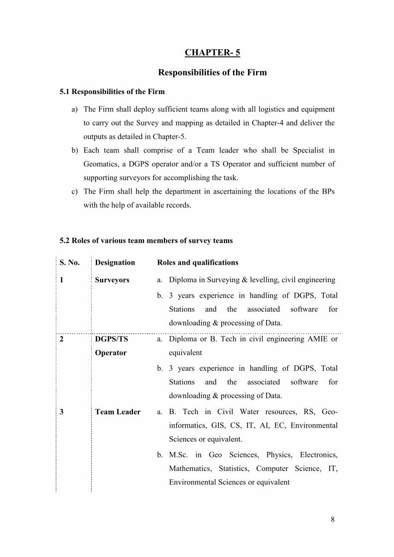
5.2 Roles of various team members of survey teams
S. No. Designation Roles and qualifications
1 Surveyors a. Diploma in Surveying & levelling, civil engineering
b. 3 years experience in handling of DGPS, Total
Stations and the associated software for
downloading & processing of Data.
2 DGPS/TS
Operator
a. Diploma or B. Tech in civil engineering AMIE or
equivalent
b. 3 years experience in handling of DGPS, Total
Stations and the associated software for
downloading & processing of Data.
3 Team Leader a. B. Tech in Civil Water resources, RS, Geo-
informatics, GIS, CS, IT, AI, EC, Environmental
Sciences or equivalent.
b. M.Sc. in Geo Sciences, Physics, Electronics,
Mathematics, Statistics, Computer Science, IT,
Environmental Sciences or equivalent
8
c. MCA or equivalent.
d. 2 years experience in handling of DGPS, Total
Stations and the associated software for
downloading & processing of Data.
e. 2 years experience in the field of Signal / Image
Processing / GIS (for B.Tech/MCA/M.Sc) in any
Image Processing and GIS Software.
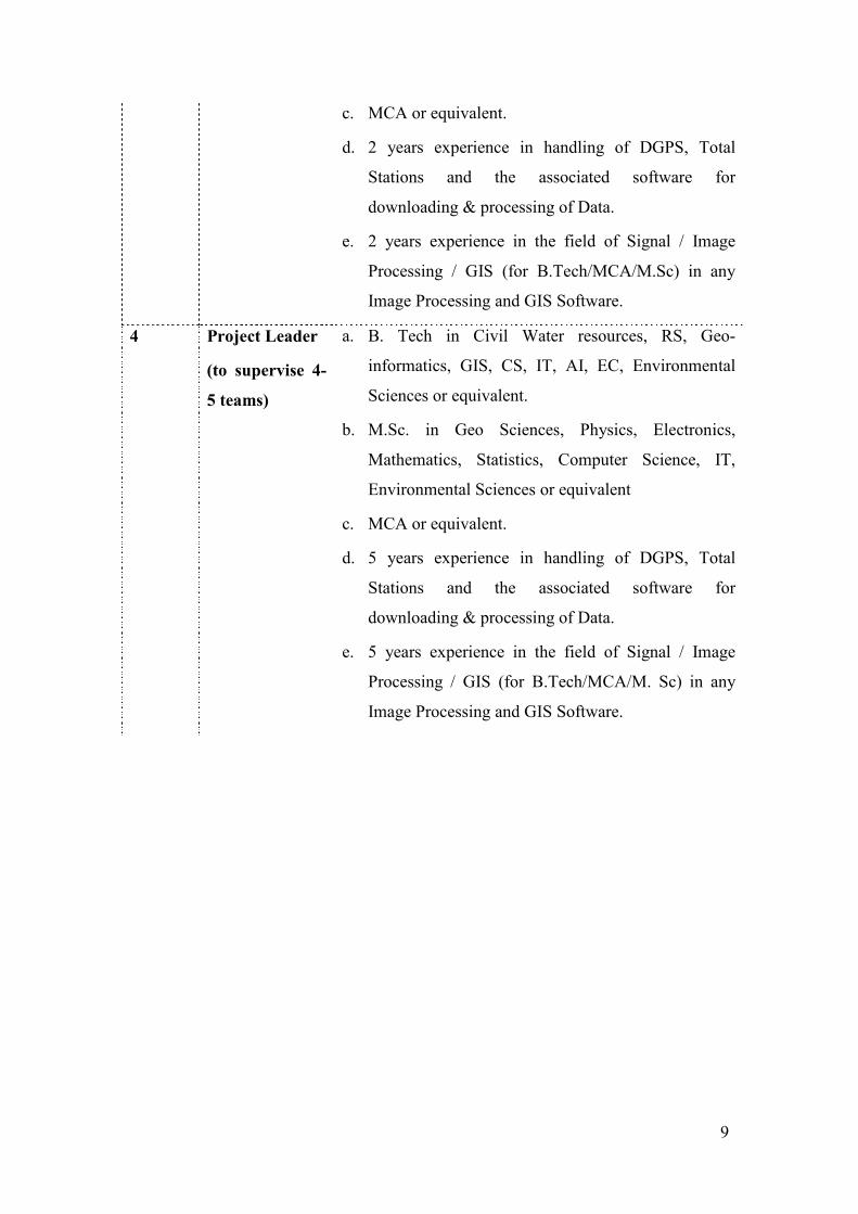
4 Project Leader
(to supervise 4-
5 teams)
a. B. Tech in Civil Water resources, RS, Geo-
informatics, GIS, CS, IT, AI, EC, Environmental
Sciences or equivalent.
b. M.Sc. in Geo Sciences, Physics, Electronics,
Mathematics, Statistics, Computer Science, IT,
Environmental Sciences or equivalent
c. MCA or equivalent.
d. 5 years experience in handling of DGPS, Total
Stations and the associated software for
downloading & processing of Data.
e. 5 years experience in the field of Signal / Image
Processing / GIS (for B.Tech/MCA/M. Sc) in any
Image Processing and GIS Software.
9
CHAPTER- 6
Technical criteria for selection of Firms 6.1 Technical criteria for selection of Firms:
a) The Tenderer should be an ISO 9001 or equivalent certified company for
providing GIS services – Copy of Certification must be furnished
b) The Tenderer should possess all requisite licenses, registrations etc., and the
same should be obtained invariably before transacting business with A.P.
Forest Department.
c) The bidder must have experience in DGPS/TS based surveying and mapping
and GCP establishment for last 5 years as on bid calling date, preferably the
forest areas, village cadastral boundaries and the areas with hostile conditions.
d) The bidder must have minimum experience of DGPS/TS based survey of more
than 1000 km2 area - testimonials from the clients must be furnished.
e) The bidders shall have at least 1 set of dual DGPS frequency receivers & 2
single frequency DGPS receivers.
f) The bidder must have affiliation/recognition with ISRO/ NRSC/ SRSACs/
SAC/ NASA/ any Government organization or institution dealing with
Geomatics activities.
g) The bidder must have at least 15 man power on company roll with required
skills & qualifications to handle DGPS/TS and its associated software, as well
as Geomatics software - details must be furnished along with their salary
slips
h) The bidder should have executed 15 Geomatics works like Survey/
Photogrammetry / Remote Sensing & Image Processing - details must be
furnished.
i) The bidder shall either be a Society/firm/company registered under Societies
Act/ the Indian Partnership Act/ Indian Companies Act 1956 or as the case
may be for at least 5 years as on 31st March 2011.
j) The bidder shall not have been blacklisted anywhere.
10
CHAPTER- 7
7.1 Procedure for affixing a few missing boundary pillars:
i. This can be done by the conventional method, i.e., Compass & chain survey.
Missing boundary pillars should be re-located with the help of a copy of the
original Surveyed sketch of the Forest Block in question along with its Field
book.
ii. With the help of Foreword & Backward Bearings of the adjacent existing
boundary pillar/s the location of the missing pillar/s can be easily arrived at.
7.2 Procedure for affixing boundary pillars of a block where almost all the
pillars are missing:
In case of those Forest Blocks where almost all the forest boundary pillars have
disappeared/are missing, the Chain & Compass survey readings will not be of
much use in the absence of any identifiable field mark/reference point.
Hence it is proposed to take up this work using the latest technologies like GIS &
GPS.
The following procedure is suggested using GPS & GIS, generically:-
a) Verification of Field Book entries & filling up of missing data, if any:
Survey Field book appended to the surveyed sketch of the Block and as it has
appeared in the Gazette notifications, should be verified for correctness of
bearings and measurements (angles and distances).
b) Verification of the closing error, if any:
The closing error should be verified by using ‘Auto CAD/CogoCad software,
and the area arrived at should be matched with the recorded area in the
surveyed sketch & Gazette Notifications. If the areas do not tally, the same
should be sorted out by visiting the field. The software is easy to use & can be
used by any person who has the knowledge of plotting using computers.
Corrections may be applied/ carried out, if closing error exists, before
proceeding to Step c.
11
c) One or more surveyed stations mentioned in the map/Notifications should be
identified on the ground jointly by the Team consisting of Forest, Revenue,
Survey & Settlement officials and the village elders. Preference shall be given
to the stations having natural features and which can be clearly identified on
the ground like village Tri-junction points, from the description of the forest
boundary given.
Joint-inspection notes/proceedings, to this affect, shall be drafted & recorded
duly signed by all the members of the Team present during the joint exercise.
It should be ensured that the station so identified is exactly the same station
which was located during the formation of Block and not moved since then.
d) Using the Differential Global Positioning System (DGPS) Latitude and
Longitude readings of the identified station (in Step c) should be taken &
recorded. This reading may be corrected with the help of base files to obtain
greater accuracy. The field files can be sent through e-mail to Geomatics
Centre for differential correction.
e) Survey field book data (Bearings & distances)may be converted into
differentially corrected Geographic coordinates (Lat-Longs & distances),
using the data obtained at Step(d) . Data processing can be carried out using
appropriate methodology and software.
f) Now with the help of the data generated in Step e, all the boundary
pillars/survey stations could be correctly located with the help of real time
GPS instruments (may be procured by the Department or taken on Hire-charge
basis locally). This work can be done by forest staff themselves as they are
trained in the use of GPS/DGPS.
12
Annexure- 1 ABBREVIATIONS
ACF: Assistant Conservator of Forest
BP: Boundary Pillars
CA: Compensatory Afforestation
DFO: Divisional Forest Officer
DGPS: Differential Global Positioning System
FBO: Forest Beat Officer
FCA: Forest (Conservation) Act, 1980
FMB: Field Measurement Book. In FMBs the individual survey number maps are
maintained at a scale of 1:1000 or 1:2000. Each survey number is divided into several
sub-divisions. Each sub-division is owned by an owner. The FMB’s also depicts the
dimension of each field boundaries and the sub-divisions.
FRO: Forest Range Officer
FSO: Forest Settlement Officer
GCP: Ground Control Points
GIS: Geographic Information System
HAE: High Altitude Endurance
LPS: Local Positioning System
MSL: Mean Sea Level
SFD: State Forest Department
SOI: Survey of India
SSLR: Survey Settlement and Land Records
TS: Terminal Station
13
Annexure- 2 SOME IMPORTANT TERMS
Base Station: A base station is a receiver placed at a known point on a jobsite that
tracks the same satellites as an RTK rover, and provides a real-time differential
correction message stream through radio to the rover, to obtain centimetre level
positions on a continuous real-time basis. A base station can also be a part of a virtual
reference station network, or a location at which GPS observations are collected over
a period of time, for subsequent postprocessing to obtain the most accurate position
for the location.
OMNISTAR HP: OmniSTAR HP service is the most accurate solution available in
the OmniSTAR portfolio of correction solutions. It is a L1/L2 solution requiring a
duel frequency receiver. OmniSTAR HP corrections are modeled on a worldwide
network of reference sites using carrier phase measurement to maximize accuracy.
The expected 2-sigma (95%) accuracy of OmniSTAR HP is 10cm. It is particularly
useful for Agricultural Machine guidance and many surveying tasks.
OMNISTAR HP: OmniSTAR XP is a worldwide dual frequency high accuracy
solution. It is a L1/L2 solution requiring a dual frequency receiver. Orbit and Clock
correction data is used together with atmospheric corrections derived from the dual
frequency data. By utilizing carrier phase measurement, very high accuracy can be
achieved. OmniSTAR XP service provides short term accuracy of 1-2 inches and
long term repeatability of better than 10 centimeters, 95%CEP. It is especially suited
for Agricultural automatic steering systems.
RINEX (Receiver Independent Exchange Format): RINEX is the standard format
that allows the management and disposal of the measures generated by a receiver, as
well as their off-line processing by a multitude of applications, whatever the
manufacturer of both the receiver and the computer application.
Rover: A rover is any mobile GPS receiver that is used to collect or update data in the
field, typically at an unknown location.
WGS 84 (World Geodetic System): A geodetic datum is the tool used to define the
shape and size of the earth, as well as the reference point for the various coordinate
systems used in mapping the earth. All GPS coordinates are based on the WGS-84
datum surface.
14