

1
Rujukan Kami: JUPEM 18/7/2.148 Jld. 3 ( 17 ) Tarikh: 25 Mei 2009
Semua Pengarah Ukur dan Pemetaan Negeri
PEKELILING KETUA PENGARAH UKUR DAN PEMETAAN BILANGAN 1 TAHUN 2009
GARIS PANDUAN MENGENAI SISTEM RUJUKAN KOORDINAT DI DALAM PENGGUNAAN
GLOBAL NAVIGATION SATELLITE SYSTEM (GNSS) BAGI TUJUAN UKUR DAN PEMETAAN
1. TUJUAN
Pekeliling ini bertujuan untuk memberikan garis panduan mengenai
sistem rujukan koordinat dalam kontek penggunaan Global Navigation
Satellite System (GNSS) bagi kerja-kerja ukur dan pemetaan di
Malaysia.
2. LATAR BELAKANG
2.1 Sistem rujukan koordinat Malayan Revised Triangulation 1948
(MRT48) dengan Bukit Kertau sebagai titik asalan (origin) telah
digunakan bagi aktiviti pemetaan dan ukur kadaster sejak tahun
1948 di Semenanjung Malaysia. Datum rujukan geodetik bagi
sistem ini adalah Datum Kertau yang menggunakan elipsoid
Modified Everest (Kertau). Bagi Sabah, Sarawak dan Labuan
pula, aktiviti ukur dan pemetaan telah dijalankan dengan
2
menggunakan sistem rujukan koordinat Borneo Triangulation
1968 (BT68) dengan Bukit Timbalai sebagai titik asalan. Datum
rujukan geodetik bagi BT68 adalah Datum Timbalai yang
menggunakan elipsoid Modified Everest (Timbalai).
2.2 Penggunaan teknologi GNSS bagi kerja-kerja ukur dan pemetaan
di Malaysia telah bermula sejak tahun 1989. Dalam hal ini,
Jabatan Ukur dan Pemetaan Malaysia (JUPEM) telah
menghasilkan sistem-sistem rujukan koordinat dengan
menggunakan teknik Global Positioning System (GPS), iaitu
Peninsular Malaysia Geodetic Scientific Network (PMGSN94)
pada tahun 1994, diikuti dengan East Malaysia Geodetic
Scientific Network (EMGSN97) pada tahun 1997. Seterusnya
dalam tahun 2003, kerangka rujukan geodetik GPS pasif tersebut
telah diperkukuhkan bagi menghasilkan Malaysia Primary
Geodetic Network (MPGN2000).
2.3 Dalam pada itu, antara tahun 1998 dan 2008, JUPEM telah
membangunkan rangkaian-rangkaian GPS/GNSS aktif, iaitu
Malaysia Active GPS System (MASS) antara tahun 1998 dan
2001 dan diikuti dengan penubuhan Malaysia Real-Time
Kinematic GNSS Network (MyRTKnet) antara tahun 2002 dan
2008.
2.4 Bagi memenuhi tuntutan semasa yang menjurus kepada
penggunaan datum rujukan global yang bersifat geosentrik,
JUPEM telah selanjutnya melancarkan datum rujukan geodetik
baru yang seragam bagi kerja-kerja ukur dan pemetaan di
Malaysia pada 26 Ogos 2003. Datum ini dikenali dengan nama
Geocentric Datum of Malaysia (GDM2000), di mana elipsoid
rujukan adalah Geodetic Reference System 1980 (GRS80). Titik
asalan bagi sistem-sistem rujukan koordinat yang berasaskan
GDM2000 ini adalah di pusat jisim bumi (geosentrik).

3
2.5 Pada tahun 2004 dan 2005 telah berlaku gempa bumi besar,
masing-masingnya bermagnitud 9.2 dan 8.7 pada skala Ritcher di
Sumatra, Indonesia dan kejadian ini telah menyebabkan anjakan
yang signifikan terhadap sistem koordinat GDM2000.
Sehubungan itu, pemantauan anjakan keatas sistem-sistem
rujukan koordinat telah dilakukan oleh JUPEM secara berterusan
melalui analisis anjakan ke atas stesen-stesen MyRTKnet.
Analisis mendapati bahawa sistem-sistem rujukan koordinat yang
berasaskan GDM2000 perlu disemak dan dihitung semula,
terutamanya bagi kerja-kerja pengukuran yang memerlukan
penggunaan sistem rujukan koordinat yang berkejituan tinggi
seperti di dalam bidang geodesi dan geodinamik.
2.6 Hasil daripada semakan dan hitungan semula tersebut yang
menggunakan produk data GPS bermula 1 Januari 2006 hingga
30 April 2009, siri set koordinat baru yang dikenali sebagai
GDM2000 (2009) bagi rangkaian-rangkaian GNSS/GPS aktif dan
pasif telah diterbitkan oleh JUPEM.
3. GARIS PANDUAN PENGGUNAAN SISTEM RUJUKAN KOORDINAT
Penerangan lebih lanjut tentang amalan penggunaan sistem rujukan
koordinat terkandung di dalam dokumen Technical Guide to the
Coordinate Reference Systems seperti di Lampiran ‘A’ yang disertakan.
Intisari kandungan garis panduan tersebut adalah seperti berikut:

4
Perenggan Perkara
1. INTRODUCTION
2. OLD TRIANGULATION NETWORKS
2.1 MALAYAN REVISED TRIANGULATION 1968 (MRT68)
2.2 BORNEO TRIANGULATION 1968 (BT68)
3. GPS-BASED NETWORKS
3.1 PENINSULAR MALAYSIA GEODETIC SCIENTIFIC
NETWORK 1994 (PMGSN94)
3.2 EAST MALAYSIA GEODETIC SCIENTIFIC NETWORK
1997 (PMGSN97)
4. GEOCENTRIC DATUM OF MALAYSIA (GDM2000)
4.1 INTRODUCTION
4.2 MALAYSIA ACTIVE GPS SYSTEM (MASS)
4.3 MALAYSIA PRIMARY GEODETIC NETWORK 2000
(MPGN2000)
4.4 MALAYSIA REAL-TIME KINEMATIC GNSS NETWORK
(MyRTKnet)
5. REVISION OF GDM2000
5.1 MAJOR SUMATRAN EARTHQUAKES IN 2004, 2005
AND 2007
5.2 MyRTKnet IN GDM2000 (2009)
5.3 MPGN200 IN GDM2000 (2009)
6. CONCLUSION
4. PEMAKAIAN
4.1 Sistem-sistem rujukan koordinat yang dinyatakan di dalam
pekeliling ini hendaklah digunakan berdasarkan tarikh-tarikh
tertentu seperti yang dinyatakan dalam Jadual 1 dan Jadual 2 di
bawah:
5
Jadual 1 : Jaringan GPS/GNSS Pasif Malaysia
Sistem Rujukan Koordinat Bil
Sistem Koordinat Datum Geodetik
Tarikh Penggunaan
1 Peninsular Malaysia Geodetic Scientific Network 1994 (PMGSN94)
WGS84 Ellipsoid: WGS84 Reference Frame: WGS84 Epoch: 1987.0
1 Januari 1994 hingga
22 Ogos 2003
2 East Malaysia Geodetic Scientific Network 1997 (EMGSN97)
WGS84 Ellipsoid: WGS84 Reference Frame: WGS84 (G783) Epoch: 1997.0
1 Januari 1997 hingga
22 Ogos 2003
GDM2000 Ellipsoid: GRS80 Reference Frame: ITRF2000 Epoch: 2000.0
23 Ogos 2003 hingga
30 April 2009 3
Malaysia Primary Geodetic Network 2000 (MPGN2000) GDM2000 (2009)
Ellipsoid: GRS80 Reference Frame: ITRF2000 Epoch: 2000.0
Mulai 1 Mei 2009
Jadual 2 : Jaringan GPS/GNSS Aktif Malaysia
Sistem Rujukan Koordinat Bil
Sistem Koordinat Datum Geodetik
Tarikh Penggunaan
1 Malaysia Active GPS System (MASS)
GDM2000 Datum: GRS80 Reference Frame: ITRF2000 Epoch: 2000.0
1 Januari 1999 hingga
30 April 2009
GDM2000 Datum: GRS80 Reference Frame: ITRF2000 Epoch: 2000.0
12 Mei 2004 hingga
30 April 2009 2
Malaysia Real-Time Kinematic GNSS Network (MyRTKnet) GDM2000 (2009)
Datum: GRS80 Reference Frame: ITRF2000 Epoch: 2000.0
Mulai 1 Mei 2009
4.2 Bagi pengguna-pengguna yang terlibat di dalam kerja-kerja ukur
yang memerlukan ketepatan dan kejituan yang tinggi, khususnya
bidang geodesi dan geodinamik, tarikh penggunaan sistem-

6
sistem rujukan koordinat berasaskan GDM2000 adalah sehingga
31 Disember 2005, manakala tarikh penggunaan sistem-sistem
rujukan koordinat berasaskan GDM2000 (2009) adalah mulai
1 Januari 2006.
4.3 Pengguna-pengguna boleh mendapatkan nilai-nilai koordinat dan
maklumat lokasi bagi setiap stesen trigonometri dan stesen
GPS/GNSS dengan menghubungi Ibu Pejabat JUPEM, Kuala
Lumpur atau dengan melayari Laman Web JUPEM, iaitu
http://www.jupem.gov.my. Selain itu, JUPEM juga turut
menyediakan maklumat dan perkhidmatan penukaran koordinat
dan transformasi datum bagi semua sistem rujukan koordinat
serta unjuran peta kepada para pengguna.
5. TARIKH BERKUATKUASA Pekeliling ini adalah berkuatkuasa mulai tarikh ianya dikeluarkan. Sekian, terima kasih. “BERKHIDMAT UNTUK NEGARA”
( DATUK HAMID BIN ALI ) Ketua Pengarah Ukur dan Pemetaan Malaysia
7
Salinan kepada: Timbalan Ketua Pengarah Ukur dan Pemetaan Pengarah Ukur Bahagian (Pemetaan) Pengarah Ukur Bahagian (Kadaster) Pengarah Bahagian Geospatial Pertahanan Setiausaha Bahagian (Tanah, Ukur dan Pemetaan) Kementerian Sumber Asli dan Alam Sekitar Pengarah Institut Tanah dan Ukur Negara (INSTUN) Kementerian Sumber Asli dan Alam Sekitar Pengarah Pusat Infrastuktur Data Geospatial Negara (MaCGDI) Kementerian Sumber Asli dan Alam Sekitar Ketua Penolong Pengarah Unit Ukur Tanah, Cawangan Pengkalan Udara dan Maritim Ibu Pejabat Jabatan Kerja Raya Malaysia Penolong Pengarah Unit Ukur Tanah, Bahagian Kejuruteraan Awam Ibu Pejabat Jabatan Perumahan Negara Setiausaha Lembaga Jurukur Tanah Semenanjung Malaysia Setiausaha Lembaga Jurukur Tanah Sabah Setiausaha Lembaga Jurukur Tanah Sarawak

Technical Guide to the
Coordinate Reference Systems
JABATAN UKUR DAN PEMETAAN MALAYSIA2009
Lampiran ‘A’
i
TABLE OF CONTENTS 1. INTRODUCTION 1
2. OLD TRIANGULATION NETWORKS 2
2.1 MALAYAN REVISED TRIANGULATION 1968 (MRT68) 2
2.2 BORNEO TRIANGULATION 1968 (BT68) 5
3. GPS-BASED NETWORKS 7
3.1 PENINSULAR MALAYSIA GEODETIC SCIENTIFIC NETWORK 1994 (PMGSN94) 7
3.2 EAST MALAYSIA GEODETIC SCIENTIFIC NETWORK 1997 (EMGSN97) 10
4. GEOCENTRIC DATUM OF MALAYSIA (GDM2000) 12
4.1 INTRODUCTION 12
4.2 MALAYSIA ACTIVE GPS NETWORK (MASS) 12
4.3 MALAYSIA PRIMARY GEODETIC NETWORK 2000 (MPGN2000) 14
4.4 MALAYSIA REAL-TIME KINEMATIC GNSS NETWORK (MyRTKnet) 17
5. REVISON OF GDM2000 19
5.1 MAJOR SUMATRAN EARTHQUAKES IN 2004, 2005 AND 2007 19
5.2 MyRTKnet IN GDM2000 (2009) 24
5.3 MPGN2000 IN GDM2000 (2009) 25
6. CONCLUSION 26
REFERENCES 27

1
1. INTRODUCTION
1.1 Coordinate reference systems have been established in many regions
around the world by national mapping authorities since the 19th
century, using conventional surveying techniques and procedures.
Most of them use local datums that are confined to small areas of the
globe, fit to limited areas to satisfy national mapping requirements.
This is also the case with Malaysia where it has in place two
old/classical triangulation networks, namely the Malayan Revised
Triangulation 1968 (MRT68) for Peninsular Malaysia and the Borneo
Triangulation 1968 (BT68) for Sabah and Sarawak.
1.2 With the recent advances in space-based positioning technology,
many countries have begun to implement and subsequently adopted a
global geocentric coordinate reference system. In relation to this,
JUPEM itself has embraced in the early 1990s the Global Positioning
System (GPS) technology with the eventual objective of adopting a
global unified datum for Peninsular Malaysia, Sabah and Sarawak.
This later led to the establishment of the Peninsular Malaysia GPS
Scientific Network 1994 (PMGSN94) and East Malaysia GPS Scientific
Network 1997 (EMGSN97), comprising of 238 stations and 171
stations respectively.
1.3 Subsequently, JUPEM established the permanent GPS tracking
stations known as Malaysia Active GPS System (MASS) at the end of
1998, with eighteen (18) stations making up the whole MASS
infrastructure. Coupled with the GPS data obtained from the
International Global Navigational Satellite System (GNSS) Service
(IGS) stations, the coordinates of MASS stations were derived from 4-
years of continuous GPS data (1999 - 2002). Collectively, these
coordinates represent the basis for the determination of the Geocentric
Datum of Malaysia (GDM2000), which was launched on 26 August
2003.
2
1.4 Between 2002 and 2008, JUPEM further developed a modern active
GNSS network with the latest state-of-the-art technology to establish
the Malaysia Real-Time Kinematic GNSS Network or MyRTKnet. The
new MyRTKnet system is able to provide real-time positioning services
at centimeter-level accuracy to users in the field.
1.5 However, there were significant displacements of positions of the
aforementioned Malaysian geodetic infrastructure as a result of two
major Indonesian earthquakes that occurred in 2004 and 2005.
Nevertheless, due to the relatively stable conditions that followed in the
past four years (albeit still quite unpredictable), JUPEM has taken
further steps to revise the coordinate reference systems, using GPS
data from the years 2006 to 2008 of MyRTKnet and IGS stations. The
resultant coordinates obtained through this endeavour are known as
GDM2000 (2009).
1.6 This technical guide then is produced to give an overview of the
coordinate reference systems that are available in Malaysia and to
assist users in understanding the concept, strategies and procedures
involved in the move towards the adoption of GDM2000 in 2003 and its
subsequent revision carried out in 2009.
2. OLD TRIANGULATION NETWORKS 2.1 MALAYAN REVISED TRIANGULATION 1968 (MRT68)
2.1.1 JUPEM could trace its origin to way back in 1885. The 1880s marked
an important phase with the commencement of widespread
trigonometrical works in various parts of Malaya, including a
triangulation survey in Penang in 1832.
2.1.2 The trigonometrical survey in Perak together with the Penang and
Province Wellesley triangulations as well as Malacca Triangulation

3
(1886 - 1888) laid the foundation for the existing control framework.
This was followed by the commencement of other trigonometrical
surveys in various parts of the country that included Selangor and
Negeri Sembilan.
2.1.3 However, the early works were so inconsistent and of questionable
quality that it was decided to re-observe the principal triangles of the
general triangulation with the object of bringing it up to modern
standards of that time. This triangulation scheme in Peninsular
Malaysia which was completed in 1916 is known as the Primary or
Repsold Triangulation.
2.1.4 The Primary or Repsold Triangulation was later replaced by a new
system known as the Malayan Revised Triangulation 1948 (MRT48).
This was subsequently followed by a lengthy process of additional
measurements and re-computation until 1968, which eventually
resulted in a system referred to as MRT68.
2.1.5 The MRT68 network consists of 77 geodetic, 240 primary, 837
secondary and 51 tertiary stations. It is based on conventional
observations with many of the triangulation points dated as far back
as 1885. The MRT68 has been adopted as a result of the re-
computations of the earlier network together with the Primary or
Repsold Triangulation (Figure 1) carried out between 1913 and 1916.
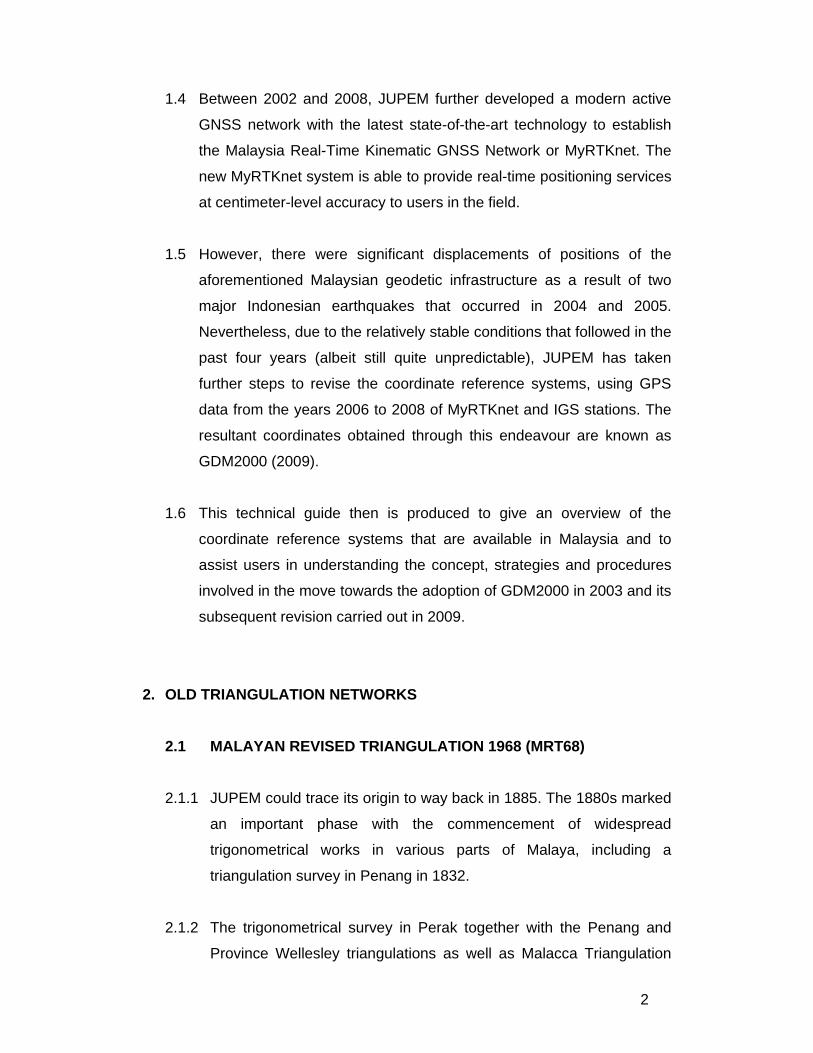
The reference ellipsoid used for MRT68 is in Table 1 below. The map
projection used for mapping in Peninsular Malaysia is Rectified Skew
Orthomorphic (RSO) and Cassini Soldner for cadastral surveying.
Table 2 tabulates the parameters for map projection used in
Peninsular Malaysia.
4
Table 1 Reference Ellipsoids for MRT68 and BT68
No. Parameter MRT68 BT68
1. Reference Ellipsoid Modified Everest Modified Everest
2. Origin Kertau, Pahang Timbalai, Labuan
3. Semi-major axis ( a ) 6 377 304.063 6 377 298.556
4. Semi-Minor Axis ( b ) 6 356 103.039 6 356 097.550
5. Flattening ( f ) 1/300.8017 1/300.8017
G001
G003
G004
G005
G007
G008
G009
G010
G011
G012
G013
G015
G016
G017
G018
G019
G020
G021
G022
G023
G024
G025
G026
G027
G028G029
G030G031
G032G033
G034
G035
G036
G037
G038 G039
G040
G041
G042
G043
G044
G045
G046
G047
G048
G049
G050
G051
G052
G053
G054
G055
G056
G057
G058
G059
G060
G061
G062
G063
G064
G065
G066
G067
G068
G069
G070
G071
G072
G073
G074G075
G076
G077
99.50 100.00 100.50 101.00 101.50 102.00 102.50 103.00 103.50 104.00
Longitude
1.00
1.50
2.00
2.50
3.00
3.50
4.00
4.50
5.00
5.50
6.00
6.50
Latit
ude
G002
G014
G084
P4
P075
Figure 1: Malayan Revised Triangulation 1968 (MRT68)

5
2.2 BORNEO TRIANGULATION 1968 (BT68)
2.2.1 Sabah started its primary triangulation work in a project known as the
Borneo West Coast Triangulation between 1930 and 1942. In around
1935, Sarawak and Brunei also began their primary triangulation
projects.
2.2.2 The Directorate of Overseas Survey (DOS) undertook the task of
readjusting the whole primary triangulation of Borneo. The adjusted
results for the Primary Triangulation of Borneo 1948 were then
published in terms of Timbalai Datum and Modified Everest ellipsoid.
2.2.3 The East Coast Triangulation was later introduced and initiated by
DOS and observations were carried out in the year 1955 to 1960.
The aim of this triangulation was to extend the Primary Triangulation
of Borneo to the eastern side of Sabah. EDM traversings were also
carried out in 1961 to 1968 to supplement the work.
2.2.4 The combined geodetic networks in Sabah and Sarawak, known as
the Borneo Triangulation 1968 (BT68), was established with the
station at Bukit Timbalai (in the island of Labuan) as the origin. BT68
consequently resulted from the readjustment of the primary control of
East Malaysia (Sabah, Sarawak and Brunei) made by the DOS.
2.2.5 The BT68 network consists of the Borneo West Coast Triangulation
of Brunei and Sabah (1930-1942), Borneo East Coast Triangulation
of Sarawak and extension of the West Coast Triangulation in Sabah
(1955-1960) as well as some new points surveyed between 1961
and 1968. This geodetic network is shown in Figure 2 with the
reference ellipsoid used given in Table 1. The map projection
employed for mapping and cadastral surveys is RSO and Table 2
shows the various parameters used.

6
Table 2: Map Projections for Peninsular Malaysia, Sabah and Sarawak
110.0 111.0 112.0 113.0 114.0 115.0 116.0 117.0 118.0 119.0
Longitude
1.0
2.0
3.0
4.0
5.0
6.0
7.0
Latit
ude
INDONESIA
SABAH
SARAWAK
SOUTH CHINA SEA
Figure 2: Borneo Triangulation 1968 (BT68)
No. Parameter Peninsular Malaysia Sabah & Sarawak
1. Projection Name Malayan RSO Borneo RSO
2. Datum Kertau Timbalai
3. Conversion Factor
1 chain = 20.11678249m (Chaney & Benoit, 1896)
1 chain= 20.11676512m (Sears, Jolly & Johnson, 1927)
4. Origin of Projection N 4° 00’ , E 102° 15’ N 4° 00’ , E 115° 00’
5. Scale Factor (Origin) 0.99 984 0.99 984

7
3. GPS-BASED NETWORKS
3.1 PENINSULAR MALAYSIA GEODETIC SCIENTIFIC NETWORK 1994 (PMGSN94)
3.1.1 As stated earlier, old triangulation networks such as MRT68 and
BT68 are regional in nature and are thus not aligned with global
geocentric coordinate frames. On the other hand, earth-centered
geocentric system is difficult to define - not until the recent
development of space-based positioning systems. This was made
possible over the last decade or so because the space-based
positioning satellites revolve around the center of mass of the earth
and are therefore related to an earth-centered or geocentric datum.
3.1.2 The World Geodetic System of 1984 or WGS84 is one such system,
which is maintained by the United States Department of Defense for
GPS-based positioning. Another is the International Terrestrial
Reference Frame (ITRF) and it is reported to be compatible with
WGS84 at the centimeter level.
3.1.3 In an effort to harness the full prowess of the space-based
technology, JUPEM has established a GPS network of 238 stations
in Peninsular Malaysia, called the Peninsular Malaysia Geodetic
Scientific Network 1994 (PMGSN94), as in Figure 3. The main
objectives of setting up PMGSN94 are to establish a new geodetic
network based on GPS observations and to analyse the existing
geodetic network. The network has been observed using four
Ashtech LX II dual frequency GPS receivers and the acquired data
was processed and adjusted in 1994.
3.1.4 In the network adjustment, a minimally constrained adjustment was
made with Kertau, Pahang, held fixed. The coordinates of Kertau are
in approximate WGS84 and derived from Doppler coordinates of
NSWC 9Z-2 reference frame. The Ashtech GPS Post-Processing

8
Software (GPPS) with broadcast ephemeris was used for the
determination of the baseline solutions. The relative accuracy of the
network is between 1-2 ppm for the horizontal coordinates and
between 3-5 ppm for the vertical coordinates. The summary of the
results of the network adjustment using Geolab network adjustment
software is tabulated in Table 3.
DOP1
DOP2
DOP3
DOP4
DOP5
GP02
G003GP04
GP05GP06
GP07
GP08
GP09GP10
GP11 GP12 GP13
GP14
GP15GP16
GP17
GP18
GP19 GP20
GP21
GP22
GP23
GP24GP25
GP26 GP27GP28
GP29 GP30 GP31 GP32GP33
GP34GP35
GP36 GP37
GP38
GP39GP40
GP41 GP42
GP43
GP44
GP45
GP47
GP48
GP49GP50
GP51
GP52
GP53
GP54
GP55
GP56GP57
GP58
GP59
GP60
GP61
GP79
GP80
GP81
GP82
P083
GP84GP85
GP86
GP87GP88
GP89
GP90GP91
GP94
GP95
GP98
GP99
G100
J416
TD01
TG01
TG03
TG04
TG05
TG06
TG07
TG09
TG10
TG11
TG13
TG14
TG15
TG18
TG19
TG20
TG24TG25
TG26
TG27TG28
TG31
TG33
TG35
TG36
TG38
TG42
TG56
TG57TG58
TG59
TG61
T190
T200
T283
13DJ
149B
251.00
P101
P102
P105
P106
P107
P201
P202
P203
P204
P205
P207
P209
P210P211
P212
P213
P214
P215
P216P217
P218
P219
P220
P221
P222
P223
P224
P225
P226
P227
P228
P229
P230
P231
P232
P233
P234P235
P236P237
P238
P239
P240
P241
P242
P243
P244P245
P246
P247
P248
P249P250
P251P252
P253
P254
P255 P256
P257
P258
P259P260
P261
P263
P264
P265
P267
P268
P269
P270
P271P272
P273P274
P275
P276
P277
P278
P279
P280P281
P282
P283 P285 P286
P287
P288
P289P290
P291
P292
P293
P295
P296
P297
P298
P299
P304
P305
P306P307
P308P309
P310
P311
P313
P314
P351
P352
P500
P808P809
S136
S290
K350
M331
99.00 99.50 100.00 100.50 101.00 101.50 102.00 102.50 103.00 103.50 104.00 104.50 105.00
Longitude
1.50
2.00
2.50
3.00
3.50
4.00
4.50
5.00
5.50
6.00
6.50
7.00
Latit
ude
Figure 3: Peninsular Malaysia GPS Scientific Network 1994
(PMGSN94)

9
Table 3: Results of Minimally Constrained Adjustment for PMGSN94
Network Adjustment Software Used
Geolab Network Adjustment
Fixed Point in 3D Kertau, Pahang
Approximate Positions 237
Number of Parameters 711
No. of Observations 3594
Redundancy 2883
Weights Used σN = 5mm ± 0.5 ppm σE = 5mm ± 0.7 ppm σU = 7mm ± 1.1 ppm
Variance Factor Used 0.9952
Chi-Square Test Passed
Station Error Ellipses Hort: 0.038 – 0.094 Vert: 0.032 – 0.080
Relative Error Ellipses Hort: 0.013 – 0.031 Vert: 0.011 – 0.030
Average Baseline Accuracies Hort: < 1.5 ppm Vert: < 2.0 ppm

10
3.2 EAST MALAYSIA GEODETIC SCIENTIFIC NETWORK 1997 (EMGSN97)
3.2.1 Following the successful completion of PMGSN94 in Peninsular
Malaysia, JUPEM began making plans to establish a similar type of
GPS-derived geodetic network in Sabah and Sarawak. For this
purpose, GPS observations were made using Trimble 4000SSE
L1/L2 receivers to establish the East Malaysia Geodetic Scientific
Network 1997 (EMGSN97) that comprises a total of 171 GPS
stations as shown in Figure 4.
3.2.2 In the network adjustment, a constrained adjustment was made with
coordinates from the Special Technical Royal Engineer (STRE) GPS
campaign fixed. Broadcast ephemeris was used for the baseline
determinations. The relative accuracy of the network is found to be
better than 1 ppm for the horizontal coordinates and 2-3 ppm for the
vertical coordinates. The summary of the results of the network
adjustment using Geolab network adjustment software is tabulated in
Table 4.
110.00 111.00 112.00 113.00 114.00 115.00 116.00 117.00 118.00 119.00
Longitude
0.50
1.50
2.50
3.50
4.50
5.50
6.50
Latit
ude
T002
M510
T006
T004
T003
M511
M502
D001
T007
T008
T005
4122
5101
T001
D002
42428045
8047
4044
T010
T009
8048T012
8028
T013
3074
3032
3046
T014T016
T015
3021
T020T019
3010
T021
6008
4127
4114
4118
2200
2011
T022
2038T029
9900
T030
T031
T026
R027
T0252005
T018
T017
6047
T045
708570866052
J01
70847082
7083
D003
T038
T037
7080
T039
4119T043
4120T042
T041
T0407079
2015
T032
1009
T034
T036
T035
1019
M501T004
M502
T101
T102
M503
M505
M504
T103
M507
M506M508
M402M403
M404
M405M509
M401
M407
M408
T114
M406
D004
M413
M412
M414M415
T108
M409
T106M410
M411
T107
T109
M416
M316
M417
M317
M315
M314
M418
T128
M313
M306T127
M419M422
M421
M420
M305
M307 M312
M311M310
T125
M304
M303
M302
M105
T124
M424
M423
T113T116
M104
M202
M301
M201
M203
T122A102
T123
T121D006
M204
T120
D005
T118
T119
T117
M102
T110
T112
M103
A101
T115M101
T111T100
T104
T105
Figure 4: East Malaysia Geodetic Scientific Network 1997 (EMSGN97)

11
Table 4: Results of Constrained Adjustment for EMGSN97
Network Adjustment Software Used
Geolab Network Adjustment
Fixed Points in 3D Five (5) Stations from STRE GPS Campaign
Approximate Positions 166
Number of Parameters 498
No. of Observations 1218
Redundancy 720
Weights used σN = 2mm ± 0.2 ppm σE = 2mm ± 0.2 ppm σU = 2.5mm ± 0.5 ppm
Variance Factor Used 0.9600
Chi-Square Test Passed
Station Error Ellipses Hort: 0.009 – 0.044 Vert: 0.010 – 0.055
Relative Error Ellipses Hort: 0.007 – 0.040 Vert: 0.008 – 0.052
Average Baseline Accuracies Hort: 0.6 ppm Vert: 0.8 ppm

12
4. GEOCENTRIC DATUM OF MALAYSIA (GDM2000)
4.1 INTRODUCTION 4.1.1 The Geocentric Datum of Malaysia or GDM2000 is the new national
geodetic datum for Malaysia and it replaces the old datum of MRT48
and BT68. It was officially launched nationwide on 26 August 2003.
4.1.2 The development of GDM2000 began firstly by the establishment of
the zero-order network of permanent GPS stations known as the
Malaysia Active GPS System (MASS). This was followed by the
establishment of the Malaysia Primary Geodetic Network 2000 or
MPGN2000 by strengthening the PMGSN94 and EMGSN97
networks via a GPS observation campaign performed at selected
stations to form a connection to the MASS network. Subsequently,
the MASS network is replaced by another network of active GNSS
stations known as the Malaysia Real-Time Kinematic GNSS Network
or MyRTKnet.
4.2 MALAYSIA ACTIVE GPS NETWORK (MASS)
4.2.1 Malaysia Active GPS Network or MASS is a permanent network of
active GPS stations that was established in 1999 and formed a
homogeneous and coherent geodetic infrastructure, covering the
whole of Malaysia. The MASS station’s GPS data were used along
with those from the International GNSS Service (IGS) stations for the
realization of the zero-order geodetic network for Malaysia.
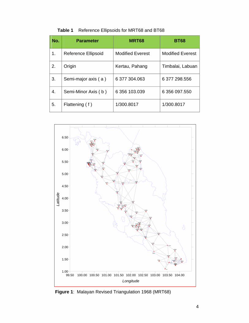
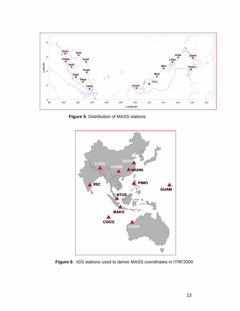
4.2.2 GPS data from seventeen (17) MASS stations (Figure 5) and eleven
(11) IGS stations (Figure 6) from 1999 to 2002 have been processed
to establish the zero-order geodetic network. The eleven (11)
permanent GPS tracking stations of the IGS world-wide network in
ITRF2000 Epoch 1997 were used as fiducial points in the processing
to obtain the MASS set of station coordinates.
13
GUAM
SHAO
WUHNKUNM
PIMO
BAKO
LHAS
IISC
COCOKARR
NTUSGUAM
SHAO
WUHNKUNM
PIMO
BAKO
LHAS
IISC
COCOKARR
NTUS
98 100 102 104 106 108 110 112 114 116 118 120
Longitude
0
2
4
6
8La
titud
e
Kuch
KinaLabu
Bint
Miri
Sand
Tawa
Arau Geti
Kual
Utmj
KuanKtpk
Ipoh
Usmp
Sega
Figure 5: Distribution of MASS stations
Figure 6: IGS stations used to derive MASS coordinates in ITRF2000
Sibu
14
4.2.3 The reference IGS station coordinates which are in ITRF2000 at
epoch 1997.0 were transformed to the same epoch as the adjusted
MASS station coordinates, i.e. ITRF 2000 at epoch 2000.00. From
the free network adjustment, the resulting accuracy of the MASS
stations with respect to the ITRF2000 reference frame at epoch
2000.0 is between 9 to 15 mm in the horizontal component and
between 12 to 19 mm in vertical component.
4.2.4 In the heavily constrained adjustment, a specific reference frame in
ITRF2000 was adopted and results indicated that the accuracy of
station coordinates is between 3 to 16 mm in the horizontal
component and between 8 to 13 mm for the vertical component.
Thus, the coordinates of the heavily constrained adjustment was
adopted as the final coordinates in ITRF2000 at epoch 2 January
2000. These new set of coordinates are known as the Geocentric
Datum of Malaysia or GDM2000 and was officially adopted on
26 August 2003.
4.3 MALAYSIAN PRIMARY GEODETIC NETWORK 2000 (MPGN2000)
4.3.1 Following the availability of MASS network in GDM2000 coordinates,
JUPEM carried out further efforts to transform the PMGSN94 and
EMGSN97 networks into the newly adopted datum. Both networks
formed the new Malaysia Primary Geodetic Network 2000
(MPGN2000) and were strengthened by connecting them to the
MASS network. This was achieved by carrying out GPS campaigns
to re-observe thirty-six (36) stations of PMGSN94 in 2000 and thirty
(30) stations of EMGSN in 2002 for a period of 48 hours to form the
strengthening network (Figures 7 and 8). The outcome defines a
new Malaysia Primary Geodetic Network 2000 (MPGN2000) for the
whole of Malaysia (Figure 9) based on the GDM2000 reference
frame.
15
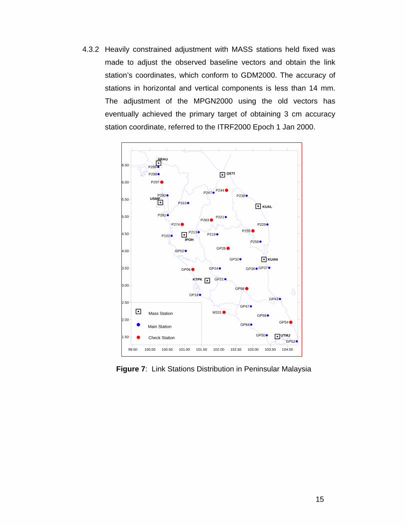
4.3.2 Heavily constrained adjustment with MASS stations held fixed was
made to adjust the observed baseline vectors and obtain the link
station’s coordinates, which conform to GDM2000. The accuracy of
stations in horizontal and vertical components is less than 14 mm.
The adjustment of the MPGN2000 using the old vectors has
eventually achieved the primary target of obtaining 3 cm accuracy
station coordinate, referred to the ITRF2000 Epoch 1 Jan 2000.
99.50 100.00 100.50 101.00 101.50 102.00 102.50 103.00 103.50 104.00
1.50
2.00
2.50
3.00
3.50
4.00
4.50
5.00
5.50
6.00
6.50
GP50
GP58
GP84
GP18
GP24
P102
P281
P310
P247
GP36
P219
P258
P221
P238
P229
GP32
P290
P298
P299
GP02
P213
GP47
GP43
GP52
GP37
GP21
P297
P244
P263P274
P255
GP28
GP06
M331
GP98
GP54
KUAL
GETI
KUAN
UTMJ
ARAU
USMP
IPOH
KTPK
Mass Station
Main Station
Check Station
Figure 7: Link Stations Distribution in Peninsular Malaysia

16
109.00 110.00 111.00 112.00 113.00 114.00 115.00 116.00 117.00 118.00 119.00 120.00
Longitude
1.00
2.00
3.00
4.00
5.00
6.00
7.00
Latit
ude
T 004M503
T112M302
M111
4119
4114
T008
T006
T001
M309
D006
D005
M305
M202
3046
7083
T041
7080
4242
M509
M416
M424
M405 M410
9900
70861009
2011
T021Kuch
Kina
Labu
Bint
Miri
Sand
Tawa
Main Station
Check Station
MASS Station
Figure 8: Link Stations Distribution in East Malaysia
100 102 104 106 108 110 112 114 116 118 120
Longitude
2
4
6
Latit
ude
Figure 9: MPGN2000 Stations in Peninsular Malaysia, Sabah & Sarawak

17
4.4 MALAYSIA REAL-TIME KINEMATIC GNSS NETWORK (MyRTKnet)
4.4.1 Beginning 2002, JUPEM has established a network known as the
Malaysia Real-Time Kinematic GNSS Network or MyRTKnet that
uses a new generation of RTK solution known as Virtual Reference
Station (VRS). MyRTKnet is based on a network of GPS reference
stations continuously connected via tele-communication network to
the control centre, situated at JUPEM headquarters in Kuala Lumpur
(Figures 11 and 12).
4.4.2 By the end of 2008, Malaysia has seventy-eight (78) RTK reference
stations for the network with fifty (50) stations covering the whole
Peninsular Malaysia, apart from fourteen (14) stations each covering
Sabah and Sarawak. The spacing between stations ranges from 30
to 100 km. Each station is equipped with either a Trimble 5700 or a
NetR5 GPS receiver, antenna, power supply and modem to
communicate with the central facility via Internet Protocol Virtual
Private Network (IPVPN) communication infrastructure.
4.4.3 The central facility at JUPEM headquarters in Kuala Lumpur
continuously gathers the information from GPS receivers at all
MyRTKnet stations and creates a living database of regional area
corrections. With MyRTKnet, a virtual reference station will be
established for any single roving GPS user near the survey area. It
also models the spatial errors that limit GPS accuracy through a
network solution and in turn generates corrections for the roving GPS
users to be positioned anywhere inside the network with an accuracy
better than a few centimetres to a few decimetres in real-time. A web
site is also available to enable downloading of GPS data for post-
processing solutions.

18
99.00 99.50 100.00 100.50 101.00 101.50 102.00 102.50 103.00 103.50 104.00 104.50 105.00
Longitude
1.50
2.00
2.50
3.00
3.50
4.00
4.50
5.00
5.50
6.00
6.50
7.00
Latit
ude
ARAU
BABH
BANT
BEHR
GETI
GMUS
GRIK
JHJY
JUML
KLAW
KUAL
KUKP
LGKW
MERS
MERU
PEKN
PUPK
SGPT
TGPG
TLOH
UPMS
USMP
UUMK
AYER
BAHA
BENT
CAME
CENE
GAJA
JRNT
KRAI
KROM
LASA
LIPI
MUAD
MUKH
PASP
PDIC
PRTS
PUSI
SBKB
SEG1
SETI
SIK1
SPGR
SRIJ
TERI
TGRH
TLKI
TOKA
Figure 11: MyRTKnet Stations in Peninsular Malaysia
109.00 110.00 111.00 112.00 113.00 114.00 115.00 116.00 117.00 118.00 119.00 120.00
Longitude
0.00
1.00
2.00
3.00
4.00
5.00
6.00
7.00
8.00
Latit
ude
MRDUBELU
RANA
TMBNKENIBEAU
TENM DATU
SEMA
SEMP
TEBE
SERAKAPI
BELA
NIAHMRDI
LAWS
AMAN
KUDA
UMSS
UMAS
SAND
TAWA
LAB1
SIB1
MIRI
BIN1
MUKH
Figure 12: MyRTKnet Stations in East Malaysia

19
5. REVISION OF GDM2000
5.1 MAJOR SUMATRAN EARTHQUAKES IN 2004, 2005 AND 2007
5.1.1 On 26 December 2004, 28 March 2005 and 12 September 2007,
three major earthquakes occurred in Sumatra, Indonesia with
magnitude 9.2, 8.7 and 7.9 on the Richter scale respectively. When
these natural catastrophes occurred, three types of motions were
generated:
a) Pre-seismic motion: earth movement before the earthquake.
b) Co-seismic motion: earth movement at the time of
earthquake.
c) Post-seismic motion: earth movement after the earthquake.
5.1.2 The earlier two aforementioned earthquakes have generated motions
and caused significant displacements to the geodetic infrastructures
in Malaysia which need to be modelled. The post-seismic motion is
the most difficult to model and the task can only be made after the
velocity and the rotating pole of the motion have been determined.
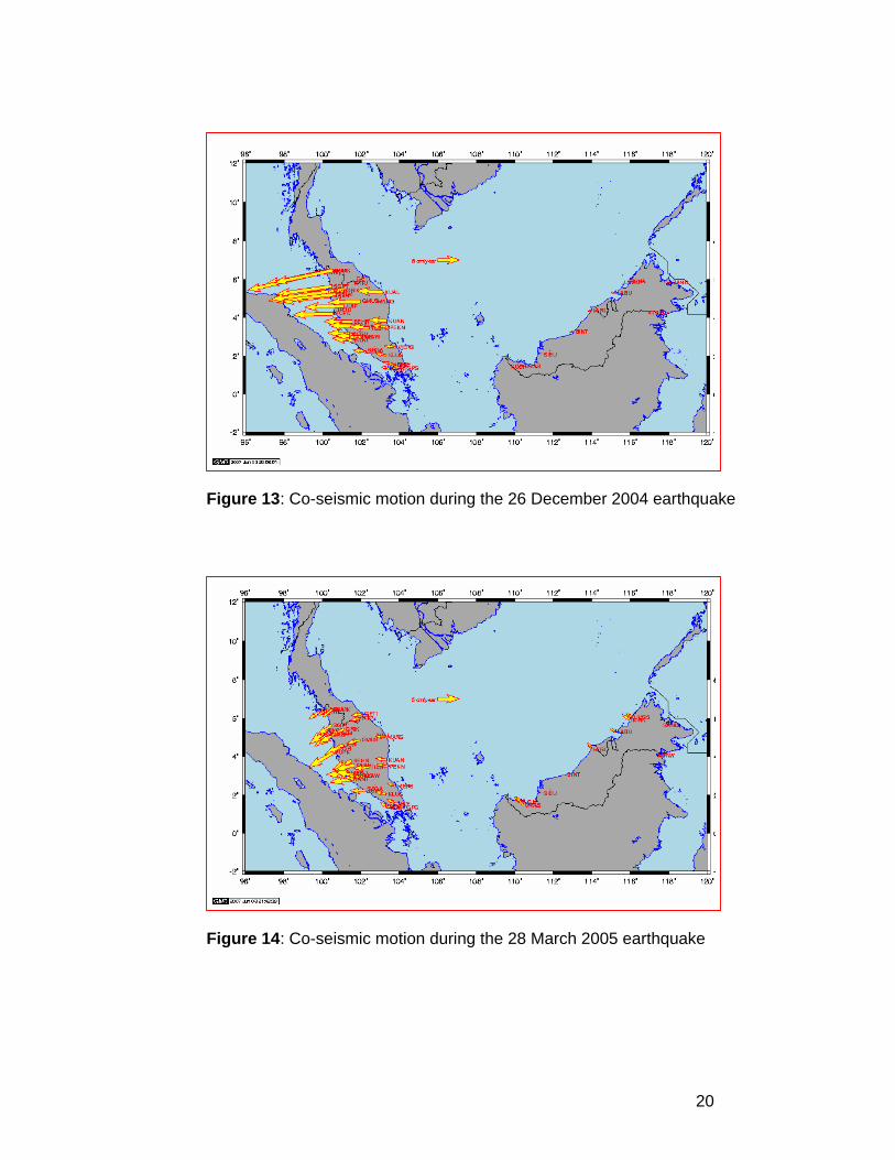
5.1.3 The co-seismic motion was deduced by comparing the coordinates of
MyRTKnet stations computed using GPS data during the first week
before the earthquake with those during the second week after the
event. Results indicate that the displacement of MyRTKnet stations
due to the co-seismic motion from the 2004 earthquake in Sumatra
was between 1.5 to 17 cm, occurring predominantly in the south-west
direction. Similarly, the results from 2005 and 2007 earthquakes
indicate displacements of between 1.0 to 6.5 cm and
1.0 to 3 cm respectively, also in the south-west direction.
5.1.4 Figures 13, 14 and 15 show the displacements of MyRTKnet stations
associated with the co-seismic motions from the 26 December 2004,
28 March 2005 and 12 September 2007 Sumatran earthquakes
respectively.
20
Figure 13: Co-seismic motion during the 26 December 2004 earthquake
Figure 14: Co-seismic motion during the 28 March 2005 earthquake

21
Figure 15: Co-seismic motion during the 12 September 2007 earthquake
5.1.5 Consecutively, the rate of the post-seismic motion was also deduced.
This was carried out by comparing the GDM2000 coordinates of
MyRTKnet stations with those computed after the 2005 earthquake
using GPS data from April to December 2005. Results indicate that
the MyRTKnet stations had experienced post-seismic motion from
the two earlier Sumatran earthquakes and moving at a rate of about
8 cm/year in the south-west direction.
5.1.6 Further computation of MyRTKnet station coordinates for the years
2006, 2007, 2008 and 2009 show that their displacement vectors
from the post-seismic motions continuously demonstrate an anti-
clockwise rotation, thus indicating a possible return to the effect of
tectonic plate motion. These yearly post-seismic motions for the
years 2006 to 2008 are illustrated in Figures 16, 17 and 18.
22
Figure 16: Post-seismic motion in 2006
Figure 17: Post-seismic motion in 2007 (January to August)

23
Figure 18: Post-seismic motion in 2008
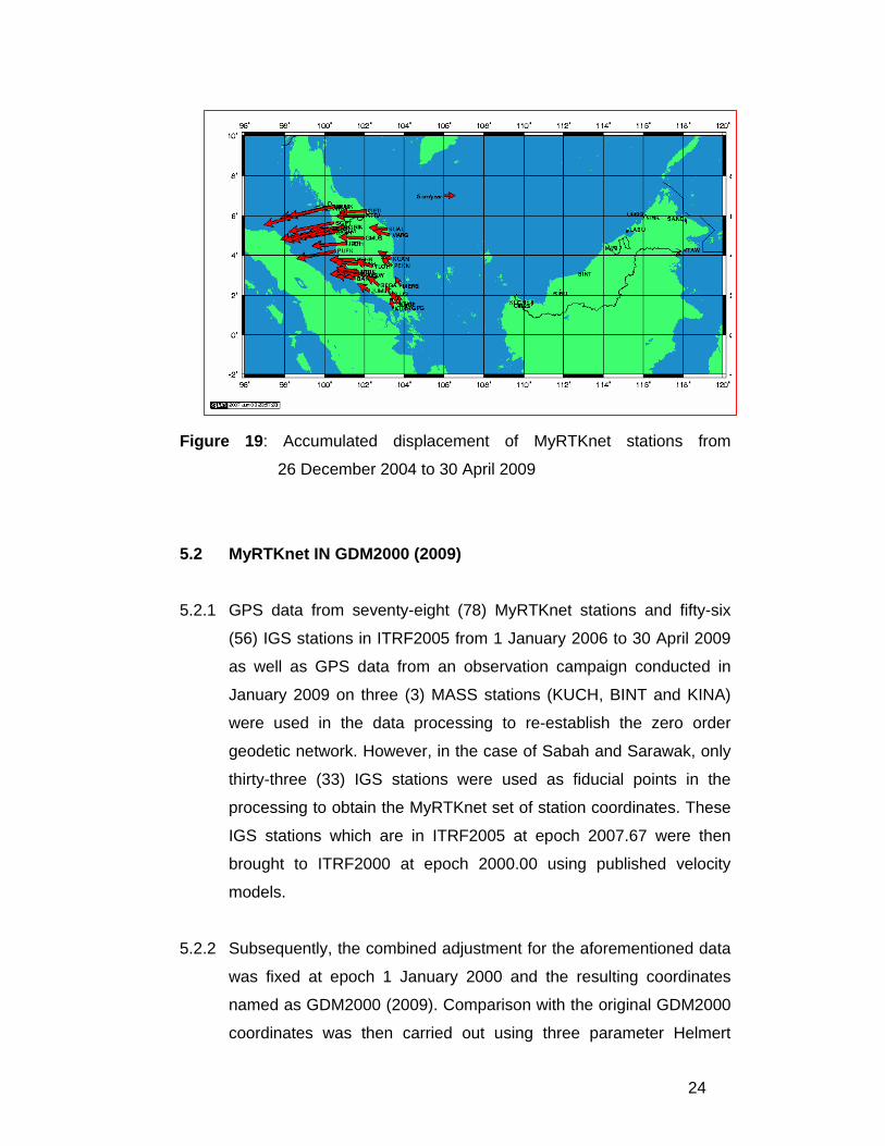
5.1.7 The accumulated displacement of MyRTKnet stations from
26 December 2004 until 30 April 2009 is shown in Figure 19. In
carrying out data adjustments, the GDM2000 coordinates of
MyRTKnet stations in Sabah and Sarawak were held fixed, as the
displacement of the coordinates in Sabah and Sarawak were found
to be very minimal.
5.1.8 From the magnitude of the displacements, which range from 1.0 to
25.8 cm, it can be concluded that the resultant displacement of
MyRTKnet stations, as a result of the co-seismic and post-seismic
motions associated with the 2004, 2005 and 2007 Sumatran
earthquakes, were significant. Consequently, their GDM2000
coordinates cannot be further utilised for high precision survey and
that they need to be revised.
24
Figure 19: Accumulated displacement of MyRTKnet stations from
26 December 2004 to 30 April 2009
5.2 MyRTKnet IN GDM2000 (2009)
5.2.1 GPS data from seventy-eight (78) MyRTKnet stations and fifty-six
(56) IGS stations in ITRF2005 from 1 January 2006 to 30 April 2009
as well as GPS data from an observation campaign conducted in
January 2009 on three (3) MASS stations (KUCH, BINT and KINA)
were used in the data processing to re-establish the zero order
geodetic network. However, in the case of Sabah and Sarawak, only
thirty-three (33) IGS stations were used as fiducial points in the
processing to obtain the MyRTKnet set of station coordinates. These
IGS stations which are in ITRF2005 at epoch 2007.67 were then
brought to ITRF2000 at epoch 2000.00 using published velocity
models.
5.2.2 Subsequently, the combined adjustment for the aforementioned data
was fixed at epoch 1 January 2000 and the resulting coordinates
named as GDM2000 (2009). Comparison with the original GDM2000
coordinates was then carried out using three parameter Helmert

25
transformation process and results indicate that the RMS fitting for
the coordinates of four (4) reference stations (KUCH, BINT, KINA
and MIRI) were less than one (1) cm in the north and east as well as
in the height components. Other stations saw large displacements
which were possibly caused by the earthquakes or seasonal
environmental effects.
5.2.3 The final combined adjustment, involving MyRTKnet and MASS
stations only, used the 2009 data and employed the original
GDM2000 reference frame as the reference by holding the
coordinates of the four (4) aforementioned reference stations fixed.
With this adjustment, the resulting coordinates of the MyRTKnet
stations were obtained and are labelled as GDM2000 (2009).
5.3 MPGN2000 IN GDM2000 (2009)
5.3.1 Apart from producing MyRTKnet stations in GDM2000 (2009)
coordinates, similar efforts were also made for the MPGN2000
stations. In order to establish MPGN2000 with GDM2000 (2009)
coordinates, it is necessary to firstly ascertain the thirty-six (36) link
stations between PMGSN94 and MASS (refer to Section 4.3.1) in
GDM2000 (2009). This approach requires adjustment to be
performed using the October to November 2000 GPS vectors of
those link stations and ten (10) MASS stations, by fixing them to the
GDM2000 (2009) coordinates of the MASS stations. With the link
stations in GDM2000 (2009), the next step taken is to perform the
adjustment using the GPS vectors of the remaining PMGSN94
stations. Similar process is carried out for EMGSN97 using thirty (30)
link stations (refer to Section 4.3.2).
5.3.2 Results indicate that the coordinate displacement of the MPGN2000
network in Peninsular Malaysia is not linear and displays elastic
properties. In addition, the displacements also differ from one station
to another. Thus, any type of modelling of the actual displacement
26
needs a long period of monitoring in order to produce precise
parameters. As an alternative, a multiple regression model was
subsequently produced to provide a relationship between the
MPGN2000 in GDM2000 and MPGN2000 in GDM2000 (2009). In
order to validate the accuracy of the multiple regression model, GPS
observations were carried out at selected MPGN2000 stations and
results showed that the coordinates of MPGN2000 in GDM2000
(2009) stations are at cm-level accuracy.
6. CONCLUSION
6.1 JUPEM has successfully established both active and passive GNSS
networks to replace the old triangulation networks in Malaysia. These
new networks will facilitate the development and enhancement of
various surveying and mapping activities and meet the requirements of
all types of users, ranging from the novice to the scientists.
6.2 The GDM2000 supersedes the classical geodetic datums in Malaysia
and has been established with respect to a geocentric reference frame
defined in ITRF system at ITRF2000 epoch 2 January 2000 at an
accuracy of 1 cm. On the other hand, with the reference frame and
epoch maintained, the new GDM2000 (2009) coordinates have taken
into account the displacements and movements resulting from the
Sumatran earthquakes in 2004, 2005 and 2007. This new
GDM2000 (2009) would be continuously maintained and managed
through the use of MyRTKnet permanent tracking stations to ensure
the availability of a highly accurate, homogeneous and up-to-date
datum for Malaysia.
27
REFERENCES Abu et al. (1998), Towards the Next Millienium: Current Status, Preliminary
Results and Applications of Malayssian Active GPS System), Paper presented
at the Directors of Surveys Conference, Kuala Lumpur, October 8-9.
Abu, S. (2002), Determination of Malaysian Geodetic GPS Network in the
ITRF2000, Universiti Teknologi Malaysia
Abu, S & Mohamed, A.B. (1997), Sea Level Monitoring System (Proposed
Malaysian Active Control System), Paper presented at the Departmental
Management Meeting, Riviera Bay Resort, Melaka, July 21-22.
Altamimi, Z., P. Sillard, and C. Boucher (2002), ITRF2000: A new release of the
International Terrestrial Reference Frame for earth science application, J.
Geophys. Res., 107(B10), 2214,doi:10.1029/2001 JB000561.
Bitwise Ideas Inc. (1998), Geolab 3.9 Reference Manual, 89 Auriga Drive
Nepean, Ontario Canada
Bowring, B.R. (1985), The accuracy of geodetic latitude and height equations,
Survey Review 28(218): 202-206.
Burford, B.J. (1985), A further examination of datum transformation parameters
in Australia The Australian Surveyor, vol.32 no. 7, pp. 536-558.
Bursa, M. (1962), The theory of the determination of the non-parallelism of the
minor axis of the reference ellipsoid and the inertial polar axis of the Earth, and
the planes of the initial astronomic and geodetic meridians from observations of
artificial Earth Satellites, Studia Geophysica et Geodetica, no. 6, pp. 209-214.
Defence Mapping Agency (DMA), (1987), Department of defence World
Geodetic System 1984: its definition and relationship with local geodetic
28
systems (second edition). Technical report no. 8350.2, Defence Mapping
Agency, Washington.
Department of Survey and Mapping Malaysia, 2000, Malaysia Reference
Frame System: Current Study and GDM2000 Revision (Sistem Kerangka
Rujukan: Kajian Semasa dan Semakan GDM2000).
Department of Survey and Mapping Malaysia, 2007, Malaysia Reference
Frame System: Current Study and GDM2000 Revision (Sistem Kerangka
Rujukan: Kajian Semasa dan Semakan GDM2000).
Directorate of Colonial Surveys, 1948, Primary Triangulation of Borneo
Directorate of Colonial Surveys, 1968, Report on the Adjustment of the Primary
Control in East Malaysia and Brunei
Heiskanen and Moritz (1967), Physical Geodesy, W. H Freeman and
Company, San Francisco, USA.
Hamid Ali, Ahmad Fauzi Nordin, Samad Abu, Chang Leng Hua (2006),
MyRTKnet: Get Set and Go, Coordinates, Issues 6, 6-13
Hugentobler, U., Schaer, S., and Fridez, P. (2001), Bernese GPS Processing
Software Version 4.2, Astronomical Institute University of Berne, Switzerland.
Jamil, H et al (2002), Geocentric Datum of Malaysia, 4th Malaysia Survey
Congress, Subang aya, June 13-14.
Krakiwsky, E.J. and Thomson, D.B. (1974), Mathematical models for the
combination of terrestrial and satellite networks, the Canadian Surveyor, vol.
28, no. 5, pp. 606-615.
Richardus, Peter, and Adler, R. K., (1974), Map Pprojetions for Geodesists,
Cartographers and Geographers: Amsterdam, North-Holland Pub. Co.
29
Rothacher, M., and Mervart, L. (1996), Bernese GPS Processing Software
Version 4.0, Astronomical Institute University of Berne, Switzerland.
Shahabuddin (1978), Msc Thesis, University of Oxford, United Kingdom.
Simons W. J. F., A. Socquet, C. Vigny, B. A. C. Ambrosius, S. Haji Abu,
Chaiwat Promthong, C. Subarya, D. A. Sarsito, S. Matheussen, P. Morgan, and
W. Spakman (2007), A decade of GPS in Southeast Asia: Resolving
Sundaland motion and boundaries, J. Geophys. Res., 112, B06420,
doi:10.1029/2005JB003868
Simons W.J.F., D.L.F. van Loon, A. Walpersdolf, B.A.C. Ambrosius, J. Kahar,
H.Z. Abidin, D.A. Sarsito, S.H. Abu, and P. Morgan (2000), Geodynamics of
S.E. Asia: Final Results of the Sulawesi 1998 GPS campaign, IAG: Geod.
Beyond 2000, 121 271-277
Snyder, J.P. (1984), Map projections used by the U.S. Geological Survey.
Geological Survey Bulletin 1532, U.S. Geological Survey.
Wolf, H. (1963), Geometric connection and re-orientation of three-dimensional
triangulation nets. Bulletin Geodesique. No, 68, pp165-169.


