
1st Place and Galloway St, NE
Transportation Access Study and Improvement Plan
Final Report & Conceptual Design
August 4, 2011
Contract No.: POKA‐2006‐T‐0035‐JJ
Prepared by: Toole Design Group, LLC
In association with:
Sabra, Wang and Associates, Inc.

1 Transportation Access Study and Improvement Plan
1st Place and Galloway St, NE
1st Place and Galloway St, NE Transportation Access Study and Improvement Plan
Table of Contents
1.0 Introduction .................................................................................................................. 3
1.1. Existing Conditions ........................................................................................................................ 3
1.2. Stakeholder & Public Improvement .............................................................................................. 4
1.3. Design Criteria ............................................................................................................................... 4
1.4. Proposed Improvements and Cost Estimates ............................................................................... 5
2.0 10% Conceptual Design Development ........................................................................... 7
2.1. Alternatives Analysis ..................................................................................................................... 7
2.2. Horizontal, Vertical and Edge Geometry ...................................................................................... 7
2.3. Typical Roadway Cross Sections ................................................................................................... 8
2.4. Bicycle and Pedestrian Considerations ....................................................................................... 10
2.4.1. Pedestrian Desire Lines and Crossing Distances ................................................................. 10
2.4.2. Buffers and Traffic Calming ................................................................................................. 10
2.4.3. Shared Lane Markings and Future Trail Connections ......................................................... 11
2.4.4. Bicycle Parking .................................................................................................................... 11
2.5. Streetscape and Landscape Design ............................................................................................. 12
2.6. Public Art ..................................................................................................................................... 12
2.7. Wayfinding .................................................................................................................................. 13
2.8. Lighting ........................................................................................................................................ 13
2.9. Drainage and Erosion & Sediment Control ................................................................................. 13
2.10. Utility Impacts ......................................................................................................................... 13
2.11. Right‐of‐Way and Property Impacts ....................................................................................... 14

2 Transportation Access Study and Improvement Plan
1st Place and Galloway St, NE
2.12. Traffic Analysis and Traffic Control ......................................................................................... 14
2.13. Construction Phasing and Maintenance of Traffic .................................................................. 15
2.14. Environmental Compliance ..................................................................................................... 16
List of Appendices
Appendix A: Existing Conditions Report
Appendix B: Design Alternatives Graphics
Appendix C: Conceptual Design Plans and Illustrative Drawings
Appendix D: Horizontal Alignment Report & AutoTurn
Appendix E: Traffic Analysis Memorandum
Appendix F: Construction Cost Estimate
Appendix G: Public Meeting Materials and Notes

3 Transportation Access Study and Improvement Plan
1st Place and Galloway St, NE
1.0 Introduction
This document summarizes the planning process and 10% conceptual design for 1st Place and Galloway
Street, NE to improve multimodal functionality and area circulation. This project was initiated by the
District Department of Transportation to improve access and circulation for the confluence of
pedestrians, bicyclists, buses, and vehicles at the Fort Totten Metrorail station. The study area included
roadways and paths within 1/4‐mile of the Metrorail station. There are several significant changes
coming to the area, including a planned reconfiguration of the Riggs Road/South Dakota intersection
and several major real estate developments in various stages of planning and construction in the
immediate vicinity that will significantly increase residential and commercial densities. These and other
projects underscore the need to provide safe and efficient multimodal traffic circulation in the project
study area. The primary goal of the project is to improve circulation so all modes can safely access and
navigate the station area as the surrounding neighborhood evolves and increases the demand for the
use of the Fort Totten Metrorail station.
The following design issues were addressed:
Station access and circulation
Streetscape and urban design
Perceptions of safety for all users
Access management
Wayfinding
Traffic calming
Transit efficiency
Bicycle parking
Connections to the existing and planned regional trail network
Congestion and safety at the reconfigured Riggs Road/South Dakota intersection
1.1. Existing Conditions
The project team conducted a thorough review of existing plans, studies, and designs to build upon and
maximize the resources already invested in the project study area. Existing traffic, bus, bicycle, and
pedestrian circulation conditions were evaluated and used as a baseline to develop three multimodal
redesign alternatives for the corridor.

4 Transportation Access Study and Improvement Plan
1st Place and Galloway St, NE
Detailed documentation and analysis of existing conditions can be found as an appendix, and includes
the following content:
Existing roadway, pedestrian, and bicycle facilities overview
Data collection and traffic model development: operations, level of service, mode splits
A summary and review of the proposed future development projects in the area
1.2. Stakeholder & Public Improvement
Numerous coordination and design review meetings and field visits were conducted over the course of
the project including DDOT Divisions, DC Office of Planning, National Park Service, and Washington
Metropolitan Area Transit Authority. The primary issues that were addressed with the various agencies
included: coordination with ongoing private land developments, maintaining bus operations,
reconfiguration of the Kiss‐and‐Ride lot, and protection of National Park Service lands from
encroachment.
In addition, a series of three public meetings were held over the course of this study. Full public
meeting agendas, meeting materials, and notes can be found as an appendix. The three meetings
included:
November 17, 2009: project kick off meeting
March 22, 2010: presentation of preliminary analysis and recommendations
March 22, 2011: presentation of preferred design alternative
The key theme heard from the public across the meetings was to improve pedestrian connectivity
through the station area and to the surrounding neighborhoods, particularly by formalizing the worn
pedestrian paths across National Park Service property between Galloway and Gallatin Streets. The
other key issue raised was to improve the perception of safety through regular maintenance and
improvements such as lighting under the railroad bridges.
1.3. Design Criteria
The majority of the corridor is owned by the District of Columbia, with the section through the Fort
Totten Metrorail Station being owned by WMATA. It was understood throughout the project that the
proposed roadway improvements would be designed to District of Columbia standards with the bus‐
specific facilities designed to WMATA standards.

5 Transportation Access Study and Improvement Plan
1st Place and Galloway St, NE
Functional Classification: It is understood that the project corridor is classified as a Collector.
Design Speed: The posted speed is 25 mph, therefore a design speed would be between 25 and 30 mph.
For geometric purposes a design speed of 30 mph was used, however there were locations where
existing geometry was held to avoid significant construction impacts.
Minimum lane widths: A 12 foot minimum lane width was used for this project. The AASHTO minimum
is 10 feet for this type of roadway; however, WMATA requested larger lane widths to better
accommodate the relatively high number of busses in the corridor.
Percent of Heavy Vehicles: Based on existing traffic counts and using a conservative approach, the
percentage of heavy vehicles was assumed to be 2%.
Design Vehicles: AASHTO bus was assumed as a design vehicle along the corridor. Within the
reconfigured Kiss‐and‐Ride lot, a modified single unit truck (SU) was used to replicate a WMATA
maintenance vehicle. The WMATA Station Site and Access Planning Manual was consulted for
circulation in the Kiss‐and‐Ride lot. An AutoTurn analysis was also conducted at intersections along the
corridor and within the Kiss‐and‐Ride lot. The AutoTurn analysis for critical turn movements are
included as an Appendix.
General Guidance: The proposed design was also developed in accordance with other general guidance
including the FHWA Manual on Uniform Traffic Control Devices (MUTCD), American Association of State
Highway and Transportation Officials (AASHTO), Americans with Disabilities Act (ADA), and other
guidelines, standards and specifications as appropriate.
1.4. Proposed Improvements and Cost Estimates
The proposed improvements seek to provide a more complete network of facilities and a friendlier
environment for bicyclists and pedestrians along the corridor, while also maintaining the safe
movements of vehicular traffic. Specific improvements are discussed in the 10% Conceptual Design
Development section. The 1st Place and Galloway Street improvements include the following general
components:
geometric modifications and fully accessible (ADA) pedestrian crossings oriented to the primary
desire lines to improve pedestrian access and safety
6 Transportation Access Study and Improvement Plan
1st Place and Galloway St, NE
continuous and widened multi‐use trail facilities along the corridor including new sections along
the south side of Galloway Street, NE and the west side of 1st Place, NE
shared lane markings and signage for bicycles on 1st Place, NE and Galloway Street, NE
reconfiguration of the Fort Totten Metro station Kiss‐and‐Ride lot to improve access and
circulation for both pedestrians and motorists
streetscaping and landscaping including aesthetic design features, improved corridor lighting,
seating areas, and a rain garden
bus stop upgrades
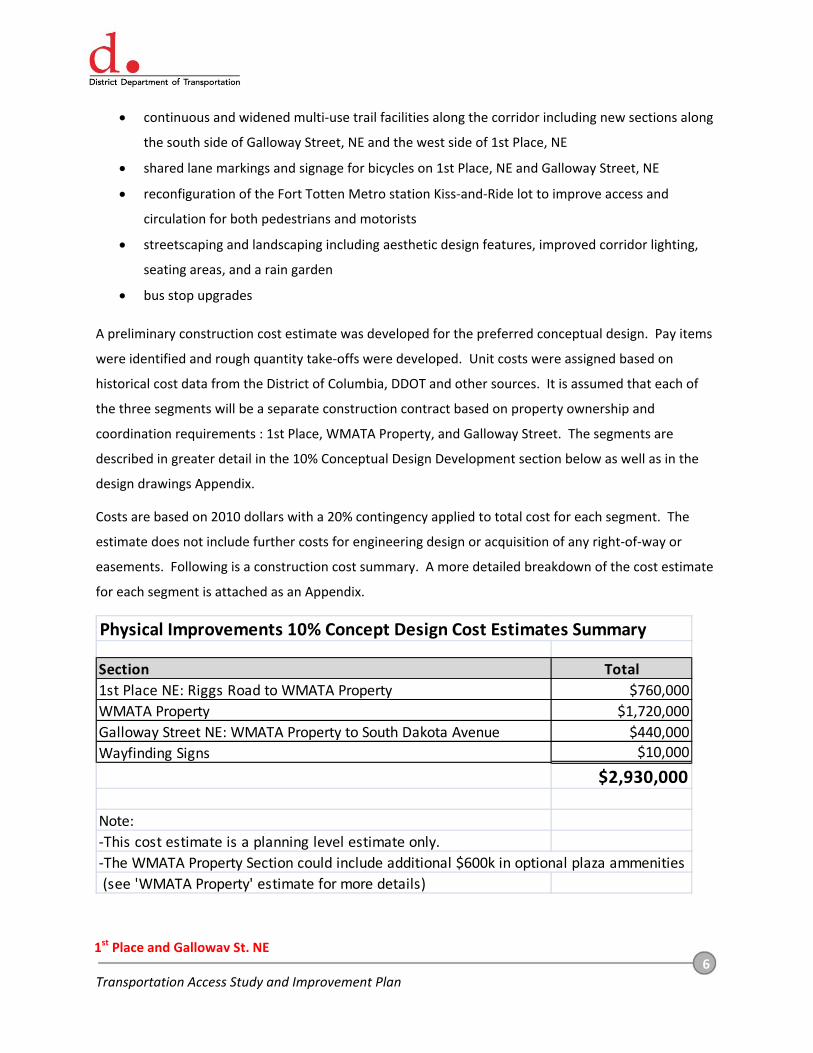
A preliminary construction cost estimate was developed for the preferred conceptual design. Pay items
were identified and rough quantity take‐offs were developed. Unit costs were assigned based on
historical cost data from the District of Columbia, DDOT and other sources. It is assumed that each of
the three segments will be a separate construction contract based on property ownership and
coordination requirements : 1st Place, WMATA Property, and Galloway Street. The segments are
described in greater detail in the 10% Conceptual Design Development section below as well as in the
design drawings Appendix.
Costs are based on 2010 dollars with a 20% contingency applied to total cost for each segment. The
estimate does not include further costs for engineering design or acquisition of any right‐of‐way or
easements. Following is a construction cost summary. A more detailed breakdown of the cost estimate
for each segment is attached as an Appendix.
Physical Improvements 10% Concept Design Cost Estimates Summary
Section Total
1st Place NE: Riggs Road to WMATA Property $760,000
WMATA Property $1,720,000
Galloway Street NE: WMATA Property to South Dakota Avenue $440,000
Wayfinding Signs $10,000
$2,930,000
Note:
‐This cost estimate is a planning level estimate only.
‐The WMATA Property Section could include additional $600k in optional plaza ammenities
(see 'WMATA Property' estimate for more details)

7 Transportation Access Study and Improvement Plan
1st Place and Galloway St, NE
2.0 10% Conceptual Design Development
2.1. Alternatives Analysis
Multiple improvement alternatives were developed, analyzed and presented to the public. The
alternatives were quite similar with inclusion of the general components mentioned above. Details of
the design alternatives as well as public comments on the alternatives are attached as appendices to
this report. Following describes the primary differences in the alternatives:
Alternative 1 – On‐street parking was not included on 1st Place NE along the Park‐and‐Ride lot.
On‐street parking was not included along the north side of Galloway Street NE west of South
Dakota Avenue. The sidewalk along the south side of Galloway Street NE did not include a
buffer.
Alternative 2 ‐ On‐street parking was not included along the north side of Galloway Street west
of South Dakota Avenue. The sidewalk along the south side of Galloway Street, NE included a
buffer.
Alternative 3 ‐ On‐street parking was included on 1st Place NE along the Park‐and‐Ride lot. On‐
street parking was included along the north side of Galloway Street NE west of South Dakota
Avenue. The sidewalk along the south side of Galloway Street NE did not include a buffer.
Based on the alternative evaluation process, public comment and coordination with stakeholders, the
preferred alternative ultimately developed most closely matched Alternative 3. All alternatives included
reconfiguring the existing Kiss‐and‐Ride parking lot, however the parking lot layout, entry and exit points
were significantly different in the ultimate preferred alternative based on detailed coordination with
WMATA.
The following sections provide a detailed description of the 10% design elements associated with the
preferred alternative.
2.2. Horizontal, Vertical and Edge Geometry
The existing horizontal alignment of 1st Place, NE and Galloway Street, NE through the project corridor
curves from a north‐south alignment to an east‐west alignment, with straight segments intermingled
with several curves. A Horizontal Design Report is attached as an appendix. Modifications to the
existing horizontal alignments are only proposed at the following locations:

8 Transportation Access Study and Improvement Plan
1st Place and Galloway St, NE
1st Place NE at Riggs Road NE– In order to accommodate vehicular movements at the 1st Place,
NE and Riggs Road NE intersection, the existing roadway width will be maintained on 1st Place
NE until PC Station 203+00.00, but will be shifted slightly east to accommodate the proposed
multi‐use path on the west side of the roadway. The improvements will narrow the roadway
south of PC Station 203+00.00, further increasing the curvature of the horizontal alignment.
Bus Driveway Entrance at Fort Totten Metro Station Plaza– In order to slow vehicular traffic
and provide additional space for the proposed multi‐use trail, the southwest corner of the bus
driveway entrance will be realigned to create a more traditional T‐intersection between 1st
Place NE and the bus driveway, opposed to the existing flatter angled turn.
Kiss & Ride Lot at Fort Totten Metro Station Plaza– In order to create additional pedestrian
space at the Fort Totten Metro Station entrance and reduce pedestrian‐motorist conflicts, the
entrance to the Kiss‐and‐Ride lot will be closed and all vehicular traffic will be re‐routed to the
existing lot exit. The improvement will also involve realigning the lot exit to accommodate two‐
way traffic.
The existing vertical alignment of 1st Place NE and Galloway Street NE is generally flat (0% to 4%), but
sloping down from a high point at Riggs Road NE and to the low point at South Dakota Avenue NE. No
modifications to the existing vertical alignments are proposed. Detailed vertical alignment design will be
completed in a later design phase.
2.3. Typical Roadway Cross Sections
The existing roadway typical sections are described in Section I‐Existing Conditions. With the conceptual
design, typical section changes are proposed for 1st Place NE and Galloway Street NE. Due to the
varying nature of the corridor, six basic typical sections are proposed as follows. The typical sections are
also presented in the Conceptual Design Drawings in the Appendix:
1st Place NE at Riggs Road NE– Proposed improvements for the first 400 feet of 1st Place NE
south of Riggs Road NE include maintaining the existing 12’ northbound and southbound
through lanes, while widening the existing 10’ turn lane to 12’. The existing through lanes will
also be striped and signed to include shared lane markings. The proposed curb line is shifted
from the existing location on both sides of the street to allow for the addition of 6’ buffer to
separate the sidewalk from the roadway on each side and widening the sidewalks. A 6’ sidewalk
will replace the existing 5’ sidewalk on the east side of 1st Place NE, and the existing 6’ sidewalk
on the west side will be widened to a 14’.

9 Transportation Access Study and Improvement Plan
1st Place and Galloway St, NE
1st Place NE West of the WMATA Parking Lot Entrance – Proposed improvements in the next
section of 1st Place NE involve both narrowing and realigning the roadway to provide additional
pedestrian and buffer space. The existing 17’ northbound and southbound lanes will be reduced
to 12’ and realigned eastward. The existing through lanes will also be striped and signed to
include shared lane markings. The existing non‐buffered 5’ sidewalks will be relocated to each
include a 6’ buffer, and will be widened to 14’ on the west side and 6’on the east side.
1st Place NE West of the Fort Totten Metro Station Entrance and Plaza – Proposed
improvements in this section of 1st Place NE requires narrowing the roadway by moving the
west side curb line eastward, which also tightens the right‐turn radius for southbound buses
entering the station bus loop. The existing two 11’ northbound and southbound through lanes
will be reduced to a single 12’ through lane in each direction with a 8’ parallel parking lane on
the east side of the road. The maintained through lanes will also be striped and signed to
include shared lane markings. The 10’ buffer on the east side of 1st Place will be reduced to 6’
and the existing railing will be removed to widen the existing 5’ sidewalk to 9’, while maintain
the curb line in the adjacent WMATA parking lot.
Galloway Street NE at the Fort Totten Metro Station Entrance Plaza – Proposed improvements
include maintaining the curb line on the north side of Galloway Street NE and creating curb
extensions on the south side that will channelize and shorten pedestrian crossings. The 12’
through lanes in each direction will be maintained and the taxi queue lane on the south side will
be maintained as a loading zone for private shuttles. Curbed median will replace the continuous
turn lane, with pockets for left turn movements at designated locations. The through lanes will
also be striped and signed with shared lane markings. The existing sidewalk on the south side
will be widened where curb extensions are installed.
Galloway Street NE East of the Fort Totten Metro Station Entrance and Plaza – Proposed
improvements will maintain the existing curb line on both sides of Galloway Street NE, with the
exception of relocating the Kiss‐and‐Ride lot entrance to the east end of the lot, and placing a
drop‐off lane in place of the current entrance. The single 12’ through lane in each direction will
be maintained. The existing through lanes will also be striped and signed to be shared lanes.
The existing sidewalks on each side of the road will also be maintained in dimension, and will be
improved with streetscape elements and crossing improvements.
Galloway Street NE to South Dakota Avenue NE– Proposed improvements will maintain the
existing curb line on both sides of Galloway Street NE. The existing 7’ parallel parking lane, 10’
westbound through lane, and the 17’ eastbound through lane will be reconfigured to create an

10 Transportation Access Study and Improvement Plan
1st Place and Galloway St, NE
8’ parking lane and 13’ through lanes in both directions. The through lanes will also be striped
and signed with shared lane markings. The buffer and sidewalk will be maintained on the north
side of the road. A 10’ sidewalk will be installed on the south side of the road, with the inclusion
of a retaining wall required to connect with the existing slope south of the road and stay within
DDOT right‐of‐way.
2.4. Bicycle and Pedestrian Considerations
2.4.1. Pedestrian Desire Lines and Crossing Distances
Several pedestrian desire lines were identified through the station area that are not directly served by
marked crossings or sidewalk connections. After crossing the bus only lane, pedestrians going to or from
the station entrance have a strong tendency to bear northwest and northeast from the station entrance
directly towards their destinations on either side of the tracks, rather than follow the marked crosswalk
under the tracks before proceeding west or east. The proposed improvements provide marked
crossings on each side of the tracks following these observed pedestrian desire lines. Moving the
crossings out from under the tracks also improves visibility.
There is also strong evidence of pedestrians desiring to cross Galloway Street NE at the east end of the
station, connecting to neighborhoods to the north. In addition, numerous worn paths are observed
connecting the south side of Galloway Street NE to the neighborhood south of the project corridor. The
proposed improvements include the addition of a new marked crossing across Galloway Street NE at the
east end of the Fort Totten Metro Station area. The National Park Service has indicated that it does not
intend to improve the connections south of Galloway Street at this time.
2.4.2. Buffers and Traffic Calming
The improvements for 1st Place NE include the creation of a buffer space between the
pedestrian/bicycle zone (currently a sidewalk; a multi‐use trail is proposed) and the roadway. A buffer
creates a physical separation between users and improves the experiential quality of the corridor for
pedestrians and bicyclists. Traffic calming measures such as curb extensions at intersections slow traffic
and improve the experience of all users. The consolidation of several wide or continuous driveways
along the corridor improves the access management and reduces the conflict points with pedestrians.

11 Transportation Access Study and Improvement Plan
1st Place and Galloway St, NE
2.4.3. Shared Lane Markings and Future Trail Connections
Shared lane markings are included through the entire corridor to facilitate on‐street bicycle movement.
The Metropolitan Branch Trail is a multi‐use trail connecting Union Station in DC to Silver Spring,
Maryland. The planned route generally parallels the tracks through the west side of the Fort Totten
Metro station area. Correspondingly, the new section of widened pathway on the west side of 1st Place,
NE is included to accommodate the future Metropolitan Branch Trail route subject to the draft
Environmental Assessment (EA).
The East Coast Greenway is envisioned as a national trail connecting Florida to Maine. The planned
route passes through the station area along Galloway Street, connecting to the Metropolitan Branch
Trail immediately west of the station. Correspondingly, the new section of wide pathway on the south
side of Galloway Street is included as a segment of the future East Coast Greenway route. The design of
this new pathway segment includes a retaining wall required to connect with the existing slope south of
the road and stay within DDOT right‐of‐way.
2.4.4. Bicycle Parking
While some bike parking currently exists directly at the Fort Totten Metro Station entrance, the
potential demand for bike parking is higher than the available spaces. Currently, approximately 10 U‐
racks (with a capacity of 20 bikes total) and 3 rentable bike lockers (with a capacity of 6 bikes total)
provide a total of 26 spaces and the only bike parking in the area. Several bicycles were observed locked
to railings and gates in higher visibility locations adjacent to the station entrance.
WMATA is currently studying projected bicycle parking needs through 2030 and evaluating higher
security bicycle parking options to fulfill that added capacity. Based on the growth projections, an
estimated 35 additional bike parking spaces will be needed at the Fort Totten Metrorail station by 2020.
By 2030, an estimated total of 100 bicycle parking spaces will be needed at the station.
According to the recommendations of the Metrorail Bicycle & Pedestrian Access Study (October 2010),
this additional bicycle parking should be located closer to the station entrances and could consist of
covered inverted‐U racks, on‐demand rental lockers, additional annual rental lockers, and additional
inverted‐U racks located in a secure room or cage. Several areas remain open immediately adjacent to
the station entrance to place the additional bicycle parking, including: between the bridge piers (which
would also funnel pedestrians to the marked crosswalk), inside the station gates, immediately east and
west of the station entrance (at the south edge of the sidewalk), and on the island west of the station.
12 Transportation Access Study and Improvement Plan
1st Place and Galloway St, NE
2.5. Streetscape and Landscape Design
The series of public meetings held between November 2009 and March 2011 informed the development
of a streetscape design for the project corridor. Key project goals were identified at the meetings and
include creating a comfortable and inviting pedestrian environment, particularly in the pedestrian plaza
at the Fort Totten Metro Station entrance. Through the public input process and subsequent design
efforts, several streetscape elements are included in the proposed design to accomplish the above goals,
and include:
Sufficient space for comfortable pedestrian use along their primary desire lines.
Buffer space between the street and sidewalk on 1st Place NE.
A wide sidewalk (approximately 10' wide) was preferred along the south side of Galloway Street,
NE, rather than reducing the sidewalk width to provide a sidewalk and buffer in the limited
right‐of‐way. (Additional width was also desired as a future segment of the East Coast
Greenway)
Street trees both along the roadway and throughout the pedestrian plaza.
Use of the decorative poured‐In‐place concrete walks in combination with decorative unit
pavers in the plaza area.
Decorative pedestrian scale lighting (Washington Globe).
Median construction under the WMATA train tracks bridge to improve pedestrian crossings and
channelize vehicular traffic.
Seating areas with benches and landscaping in the pedestrian plaza; focused adjacent to the kiss
& ride parking lot and bus bay areas.
Improved landscaping at various locations along the corridor, including street trees, a rain
garden and tree canopy areas in the pedestrian plaza.
2.6. Public Art
At the second public meeting, on March 22nd, 2010 it was indicated that an art piece is needed for the
traffic circle at 3rd Street NE and Hamilton Street NE, located immediately north of the Fort Totten Metro
Station Kiss‐and‐Ride lot. While this intersection is outside of the project limits, recommendations for
the plaza at the station entrance include the use of several paving patterns, and reservation of space for
art pieces such as sculptures.

13 Transportation Access Study and Improvement Plan
1st Place and Galloway St, NE
2.7. Wayfinding
The improvements include a wayfinding sign schedule, which focuses on directional guidance oriented
to key destinations including the Fort Totten Metro Station and amenities in the surrounding
neighborhoods, such as: Lamond‐Riggs Library, University of the District of Columbia, Food & Friends,
and Keene Community Center. The signs are of the typical DDOT blue wayfinding design and will be
oriented to all users. A detailed wayfinding signage plan including sign locations and suggested
destinations can be found in the Conceptual Design Plans in the Appendix.
2.8. Lighting
Based on comments from the aforementioned public meetings, input indicated that pedestrian lighting
is inadequate in the project area; particularly under the railroad bridge in the plaza area. The proposed
lighting design shown on the design plans attached as an appendix was developed to improve the
streetscape environment and improve visibility for pedestrians. Preliminary lighting spacing was
evaluated for roadway areas, walkway areas and crosswalks within the project. Washington Globe
pedestrian lights, a DDOT standard fixture, are recommended through the project area to supplement
existing roadway lighting fixtures. Some existing roadway lighting fixtures will have to be relocated to
accommodate proposed geometric improvements. Detailed lighting design will be completed in a later
design phase.
2.9. Drainage and Erosion & Sediment Control
Proposed improvements will generally not alter existing drainage patterns. Drainage modifications are
limited to either adjusting, or removing and replacing curb inlets. The impervious surface area will
slightly increase, particularly in the pedestrian plaza area, however the proposed rain garden will
infiltrate some of the additional runoff and the additional buffer space throughout the project area can
be used to improve overall drainage infiltration. Erosion and sediment control will primarily consist of
curb inlet protection, silt fence and possible sediment traps in the disturbed areas.
2.10. Utility Impacts
The project survey included some limited subsurface utility information. Other utility information was
gathered from existing construction plans; however the coverage of these plans was limited. Additional
utilities may exist within the project area that are not shown on the project survey.

14 Transportation Access Study and Improvement Plan
1st Place and Galloway St, NE
The conceptual designs assume that some utilities will be impacted with each phase of construction.
Utility impacts based on existing surface utility features have been quantified and costs provided,
however, this cost could vary significantly depending on actual utility conflicts and subsurface
conditions. As future design progresses, a comprehensive subsurface utility survey should be
conducted. Utility stakeholders for future phases include PEPCO, Washington Gas, DC Water and Sewer
Authority, Verizon, Comcast and possibly others.
2.11. Right‐of‐Way and Property Impacts
The project included a property survey as well as a complete metes and bounds survey of the WMATA
property. The metes and bounds survey was conducted assuming DDOT would construct improvements
on WMATA property and that property would ultimately be transferred to DDOT. Based on the current
survey and property information, all of the proposed conceptual design work will take place either on
WMATA property, within DDOT Right‐of‐Way, or minimally on National Park Service (NPS) land.
Three locations should be noted for future design phases with design considerations relative to right‐of‐
way and property impacts:
The design of the new pathway segment on the south side of Galloway Street includes a
retaining wall required to connect with the existing slope south of the road and stay within
DDOT right‐of‐way.
A small wedge of proposed widened sidewalk located adjacent to the bus loop entrance may
require National Park Service property.
The realignment and consolidation of driveways and the removal of informal parking on DDOT
right‐of‐way along 1st Place, NE south of Riggs Road will require coordination with the adjacent
property owners.
2.12. Traffic Analysis and Traffic Control
A comprehensive traffic analysis was performed as a part of the project and is included as an appendix.
The traffic analysis of the proposed geometry and projected traffic volumes indicated the following
findings:
All intersections are projected to perform at a level of service D or better
No operational problems were observed at any of the WMATA parking lot intersections

15 Transportation Access Study and Improvement Plan
1st Place and Galloway St, NE
Considering the potential for diverted traffic, and that limited right‐of‐way precludes the
addition of a short eastbound right turn lane at the intersection of Galloway Street and South
Dakota Avenue, it is recommended to implement a dedicated right turn overlap phase at the
Riggs Road/South Dakota Avenue intersection.
2.13. Construction Phasing and Maintenance of Traffic
Improvements are grouped into four phases, determined by property boundaries and the recommended
improvements. 1st Place NE refers to the area from the project limit at Riggs Road NE to the entrance
for the WMATA parking lot. The Metro Plaza area is from the entrance to the parking lot to just west of
the Galloway Street/4th Street NE intersection. The Galloway Street NE section consists of the area from
4th Street NE to the project limit at South Dakota Avenue NE. The fourth phase is the installation of a
wayfinding sign system. The phases are correspond to the cost estimates for each phase included in the
Appendices. The following describes the phases of the project and considers maintenance of traffic
schemes during each phase.
Phase I (1st Place NE) ‐ The work associated with this intersection requires modifications to the
road geometrics, striping, as well as the sidewalk and buffer zone. It appears that construction
would require closure of one lane at a time on 1st Place NE to facilitate curb modifications.
Bicycle and pedestrian traffic would be detoured to either side of 1st Place NE during
construction, dependent upon curb reconstruction.
Phase II (Metro Plaza) – The work associated with this intersection requires modifications to
road and sidewalk/trail geometrics, striping, pedestrian plaza at the Fort Totten Metro entrance,
and WMATA Kiss & Ride lot. It appears that construction would require closure of one lane at a
time on 1st Place NE.. Trail/sidewalk construction could be staged so that narrow portions of
trails or sidewalks are usable at all times.
Phase III (Galloway Street NE) ‐ The work associated with this intersection requires
modifications to sidewalk geometrics and improvements in the buffer zone. It appears that
construction will have a limited impact on vehicular movement, but will require the closure of
one lane during installation of concrete pads in the roadway at existing bus stops. Bicycle and
pedestrian traffic would be able to access the sidewalk on the north side of Galloway Street NE
during most of the construction, with possible closure during the installation of concrete bus
pads on the north side of Galloway Street NE.

16 Transportation Access Study and Improvement Plan
1st Place and Galloway St, NE
Phase IV (Wayfinding Signs) ‐ The work associated with this phase involves the installation of
wayfinding signs for pedestrians and bicyclists. It appears that construction will have limited
impact of vehicular, pedestrian, and bicycle movement.
Phases I, II and III, may require brief nighttime full roadway closures or one‐way flagging operations to
accomplish construction activities in particularly constrained locations. It is also recommended that all
construction activity be preceded by an intensive public outreach effort to alert citizens to the upcoming
work and potential inconvenience.
2.14. Environmental Compliance
Future design phases should include coordination with the National Park Service and FHWA to ensure
compliance with NEPA and 4(f) environmental review requirements, including coordination with the
Metropolitan Branch Trail Final Environmental Assessment.


