まちづくりの沿革 - city of nagoya...thanks to “shichiri-no-watashi”, the only sea route...
TRANSCRIPT

名古屋のまちづくりの概要
まちづくりの沿革
Outline of Nagoya’s City Planning
City Planning History3
名古屋のまちづくりの概要Outline of Nagoya’s City Planning
まちづくりの沿革 City Planning History4
For Kiso River至 木曽川
大津通
広小路名古屋駅
鶴舞公園
中村公園名古屋城
東山公園
名城公園
名古屋港
中川運河
新堀川
堀川
Higashiyama Park
Tsuruma Park
Meijo Park
Nagoya Castle
Nakamura Park
Nagoya StationHirokoji
Otsu-dori
Shin-Horikaw
a River
Horikaw
a River
Nakagaw
a Canals
Nagoya Port
主な水道
主な鉄道
主な市電
市域の変遷明治時代
築港・埋立
大正~昭和初期
Changes in the urban area
Meiji era
Port construction/land reclamation
Taisho to early Showa era
Main watersupply
Main railways
Main streetcars
City Planning Historyまちづくりの沿革
■名古屋のまちのなりたち名古屋城ができる前の尾張地方の中心地は、清須で
した。清須城は、戦の際の水攻めへの弱さなどが懸念されたため、徳川家康は慶長15 年に名古屋台地の北西端に名古屋城の建設を命じ、清須から町ぐるみで移転(清須越)をしました。城下町の中央、城の南に近代都市名古屋の原型となる碁盤割の町割を形成すると、そこに主に町人地を配置し、碁盤割を囲む東・南・西には武家地を配置しました。城から離れた東と南の街道沿いには、有事の際に防衛拠点とするための社寺地を配置しました。
築城と同時に城郭の西から熱田湊までを結ぶ堀川の開削が行われました。熱田は熱田社の門前町としてはじまり、鎌倉時代以降は湊町、京都と東国を結ぶ街道の宿場町として、江戸時代には東海道唯一の海上路「七里の渡し」により栄えました。堀川はこの熱田と城下町を結び、生活物資の運搬水路として重要な役割を担いました。
■明治〜戦前のまちづくり明治維新後は、都市の発展の基盤となる鉄道・道路・
運河・港湾等の整備が行われました。明治19 年には国鉄( 現在のJR) 東海道線の名古屋停車場(名古屋駅)の開業に伴い、東西のメインストリートである広小路通が都心から停車場まで延伸しました。この広小路通には明治31 年に国内2 番目の路面電車が開通しました。明治40年に名古屋港が開港すると、あわせて港と都心を結ぶ南北の大動脈である大津通を整備しました。明治43 年には新堀川が竣工し、その掘削土で本市が最初に設置した都市公園である鶴舞公園を整備しました。
大正9 年に旧都市計画法が施行されたことで近代的な都市計画が始まると、本市でも都市計画区域をはじめとして、用途地域や街路、公園、運河などのまちづくりの基盤となる施設を都市計画で定めました。また耕地整理や区画整理等の面的市街地整備事業によって、本市の計画的なまちづくりは推進されました。
大正13 年6月には、名古屋港と鉄道との連絡等を目的に運河計画を都市計画決定しました。中でも昭和5 年に供用を開始した中川運河は、名古屋駅と名古屋港を結ぶことで、運河沿線の産業開発や名古屋港の発展に大きく寄与しました。また昭和12 年には中川運河を掘削して造成した名古屋港臨海部を会場に、戦前最大の名古屋汎太平洋平和博覧会を開催しました。
・ Formation of the City of NagoyaBefore the construction of Nagoya Castle, the town of Kiyosu served as the center of the Owari region. However, Kiyosu Castle was vulnerable to inundation tactics, so Ieyasu Tokugawa ordered the construction of Nagoya Castle in 1610 (Edo Era) on the northwestern edge of the Nagoya plateau. The entire town was relocated to Nagoya City (then known as “Kiyosugoshi”). The city was formed by laying streets in a checkerboard pattern to make blocks, which was considered the foundation of the modern city of Nagoya at the central and southern part of the castle. A merchant district was situated within these blocks and warrior districts were placed in the peripheral areas (eastern, southern, and western part of the town). Finally, shrines and temples were placed in the areas apart from the castle and along the main road in the eastern and southern parts of the city to serve as a defense outputs in times of emergency.While constructing the castle, the Horikawa River was dredged, connecting the west side of the castle with Atsuta Port. Development of Atsuta began as a temple town surrounding Atsuta shrine, and after the Kamakura Era, it prospered as a post town along the main road connecting Kyoto and eastern regions. During the Edo Era, the town enjoyed prosperity thanks to “Shichiri-no-watashi”, the only sea route along the Tokaido road. The Horikawa River played a central role by connecting the town of Atsuta with the castle town, serving as a shipping channel for everyday commodities.
・ City Planning from the Meiji Era through the Pre-war Period
After the Meiji Restoration, railways, roads, canals, harbors, etc. were developed to serve as a development base for the urban area. In 1886, Japanese National Railways (now reorganized as Japan Railways) opened the Nagoya Railroad Depot (Nagoya Station) along the Tokaido Line, which stretched along the city’s east-west main avenue, called Hirokoji, from the downtown area to the railway depot.In 1898, streetcar service was started along Hirokoji—Japan’s second streetcar route at the time. After Nagoya Port was opened in 1907, the main artery road Otsudori was constructed to run through the city from north to south, connecting the port and the downtown area. In 1910, the Shin-Horikawa River was dredged. Using the dredged soil, Nagoya City established the first urban park in the city, which named Tsuruma Park.In 1920, the City Planning Law (now defunct) was enforced to begin modern city planning in Japan. Accordingly, the basic infrastructures of this city such as city planning districts, use district, roads, parks, and canals were designated by city planning. In addition, Nagoya City promoted rapid land readjustment and other urban development projects, which contributed to planned urbanization.In June 1924, the City of Nagoya defined its city plan to dredge canals to connect Nagoya Port with the railway network. Nakagawa Canal started service in 1930, connecting Nagoya station and Nagoya Port and making a great contribution to the development of industries along the canal as well as of Nagoya Port itself. In 1937, Nagoya hosted the Nagoya Pan-pacific Peace Exposition, the largest exhibition in the pre-war period, at an oceanfront venue created out of soil dredged from the Nakagawa Canal.
■江戸時代の町割りCity layout in Edo Era
■明治〜戦前に整備された都市基盤Urban infrastrure established between the Meiji Era and the pre-war era
■昭和初期の栄交差点(昭和 10 年ごろ)Sakae junction in the early Showa Era (around 1935)
■名古屋汎太平洋平和博覧会会場(昭和 12 年) Venue of Nagoya Pan-Pacifi c Peace Exhibition (1937)
■現在の市街地(平成 22 年撮影) Today's city area (photograph taken in 2010)
「万治年間名古屋絵図」 Image of Nagoya in the Manji era(1658-1661)万治年間(1658年~1661年)の城下町の様子で、碁盤の目状に整然とした
「碁盤割り」がよくわかります。The foundation of the city’s orderly layout based on checkerboard pattern can still be clearly seen.
提供:一般財団法人名古屋城振興協会GENERAL INCORPORATED FOUNDATION NAGOYA CASTLE PROMOTION ASSOCIATION
名古屋のまちづくりの概要
まちづくりの沿革
Outline of Nagoya’s City Planning
City Planning History5
名古屋のまちづくりの概要Outline of Nagoya’s City Planning
まちづくりの沿革 City Planning History6
100m道 路
戦災焼失区域
主な河川市域(昭和20年)
戦後に拡大した市域
海岸線(昭和25年)
凡例 Legend復興土地区画整理事業区域Reconstruction Land Readjustment Project area
Area burned down during war
City area (1945)
Consolidated cities, towns, villages in post-war period
100-m road
Coastal line (1950)
Major rivers
平和公園テレビ塔
城
白川公園
東山公園
名古屋港
熱田
名古屋
Heiwa Park
Higashiyama Park
Nagoya Castle
TV TowerShirakawa Park
Atsuta
Nagoya Port
City Planning Historyまちづくりの沿革
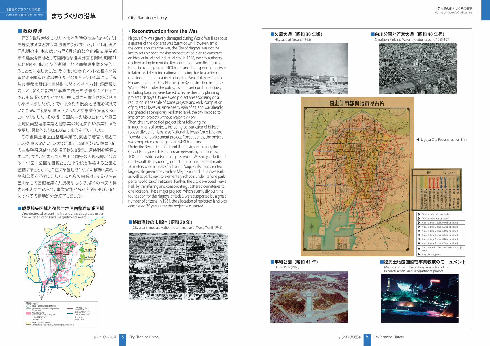
・ Reconstruction from the WarNagoya City was gravely damaged during World War II as about a quarter of the city area was burnt down. However, amid the confusion after the war, the City of Nagoya was not the last to set an epoch making reconstruction plan to construct an ideal cultural and industrial city. In 1946, the city authority decided to implement the Reconstruction Land Readjustment Project covering about 4,400 ha of land. To respond to postwar inflation and declining national financing due to a series of disasters, the Japan cabinet set up the Basic Policy related to Reconsideration of City Planning for Reconstruction from the War in 1949. Under the policy, a significant number of cities, including Nagoya, were forced to revise their city planning projects. Nagoya City reviewed project areas focusing on a reduction in the scale of some projects and early completion of projects. However, since nearly 90% of its land was already designated as temporary replotted land, the city decided to implement projects without major revision.Then, the city modified project plans following the inaugurations of projects including construction of bi-level roads/railways for Japanese National Railways Chuo Line and Toyoda land readjustment project. Consequently, the project was completed covering about 3,450 ha of land. Under the Reconstruction Land Readjustment Project, the City of Nagoya established a road network by building two 100-meter wide roads running east/west (Wakamiyaodori) and north/south (Hisayaodori), in addition to major arterial roads 50 meters wide to make grid roads. Nagoya also constructed large-scale green areas such as Meijo Park and Shirakawa Park, as well as parks next to elementary schools under its “one park per school district” inititative. Further, the city developed Heiwa Park by transferring and consolidating scattered cemeteries to one location. These major projects, which eventually built the foundation for the Nagoya of today, were supported by a great number of citizens. In 1981, the allocation of replotted land was completed 35 years after the project was started.
■戦災復興 第2 次世界大戦により、本市は当時の市域の約4 分の1
を焼失するなど甚大な被害を受けました。しかし戦後の混乱期の中、本市はいち早く理想的な文化都市、産業都市の建設を目標として画期的な復興計画を掲げ、昭和21年に約4,400ha に及ぶ復興土地区画整理事業を実施することを決定しました。その後、戦後インフレと相次ぐ災害による国家財政の悪化などのため昭和24 年には「戦災復興都市計画の再検討に関する基本方針」が閣議決定され、多くの都市が事業の変更を余儀なくされる中、本市も事業の縮小と早期収束に重点を置き区域の見直しを行いましたが、すでに約9 割の仮換地指定を終えていたため、当初の計画を大きく変えず事業を実施することになりました。その後、旧国鉄中央線の立体化や豊田土地区画整理事業など他事業の発足に伴い事業計画を変更し、最終的に約3,450haで事業を行いました。
この復興土地区画整理事業で、東西の若宮大通と南北の久屋大通という2 本の100 m道路を始め、幅員50mの主要幹線道路などを格子状に配置し、道路網を整備しました。また、名城公園や白川公園等の大規模緑地公園や1学区1公園を目標とした小学校と隣接する公園を整備するとともに、点在する墓地を1 か所に移転・集約し平和公園を整備しました。これらの事業は、今日の名古屋のまちの基礎を築く大規模なもので、多くの市民の協力のもとすすめられ、事業実施から35 年後の昭和56 年にすべての換地処分が終了しました。
■戦災焼失区域と復興土地区画整理事業区域Area destroyed by wartime fi re and areas designated under the Reconstruction Land Readjustment Project
■終戦直後の市街地 (昭和 20 年)City area immediately after the termination of World War II (1945)
■久屋大通(昭和 30 年頃)Hisayaodori (around 1955)
■平和公園(昭和 41 年)Heiwa Park (1966)
■復興土地区画整理事業収束のモニュメントMonument commemorating completion of the Reconstruction Land Readjustment project
■白川公園と若宮大通(昭和 40 年代) Shirakawa Park and Wakamiyaodori (around 1965-1974)
❶ Wide road (100 m or wider)
❷ Wide road (50 m or wider)
❸ Class 1 type 1 road (40 m or wider)
❹ Class 1 type 2 road (33 m or wider)
❺ Class 1 type 2 road (30 m or wider)
❻ Class 1 type 3 road (25 m or wider)
❼ Class 2 type 3 road (20 m or wider)
❽ Class 2 type 2 road (15 m or wider)
❾ Reconstruction land readjustment project area
❿ City planning area
❶❷❸❹❺❻❼❽❾❿
▲ Nagoya City Reconstruction Plan
Legend

名古屋のまちづくりの概要Outline of Nagoya’s City Planning
まちづくりの沿革 City Planning History8
名古屋のまちづくりの概要
まちづくりの沿革
Outline of Nagoya’s City Planning
City Planning History7
Area of land readjustment by association under the former law
Area of arable land readjustment
Area of land readjustment by public entities, etc.
Area of land readjustment by association under the new law
新法による土地区画整理組合区域
旧法による土地区画整理組合および耕地整理組合
区画整理区域内
公共団体等施行土地区画整理区域
8,916(27%)
8,958(28%)
4,297(13%)
22,171(68%)
市域32,643 ヘクタール
ヘクタール
ヘクタール
ヘクタール
ヘクタール
ヘクタール
その他の区域
10,472(32%)
Other area
10,472 ha (32%)
Area of land readjustment by public entities, etc.
4,297 ha (13%)
Area of land readjustment by association under the new law
8,916 ha (27%)
Total city area32,643 ha
Land readjustment area
22,171 ha (68%)
Area of land readjustment by association under the former law and arable land readjustment by association
8,958 ha (28%)
名鉄名古屋本線 有松駅Meitetsu Nagoya Main Line, Arimatsu Station
大将ヶ根線Taishogane Road
敷田大久手線Shikita-Okute Road
再開発ビル「ウィンハート有松」Redeveloped building (Win Heart Arimatsu)有松線
Arimatsu Road
東海道Tokaido
Legend
Area of Comprehensive Districts Development
Area for implementing Urban Redevelopment Project
Area for implementing Land Readjustment Project
Area for implementing City Road Projects
●①
●②●③
●④●⑤
●⑦●⑧●⑨
●⑥
●⑩
●⑪●❶
●❹
●❸
●❺●❻
●❷
まちづくりの沿革 City Planning History
・ Post-war Development of City AreaSince 1955, the City of Nagoya has been implementing Land Readjustment Projects, focusing on the existing city area downtown that was excluded from the Reconstruction Land Readjustment Project and old city areas requiring improvement of city infrastructure. The city also implemented the Urban Redevelopment Project in key areas, while implementing the Comprehensive Development Project in Residential Urban Area, etc. in areas where the city area environment needed to be improved.In Nagoya City,private-based land readjustment projects were implemented before the enforcement of the Land Readjustment Act in 1955. After the enforcement of the law, land readjustment projects were actively implemented in the city, partiularly in the outskirts of Nagoya.Areas in Nagoya City improved under the city land readjustment projects (including arable land readjustment projects) implemented by both the administration and private organizations affected about 22,000 ha. If the approximately 1,100 ha currently under construction are included, the area covers nearly 68% of the entire city area. Further, Nagoya City completed an Urban Redevelopment Project in 13 districts (implemented by both the administration and private organizations) and is currently working on four other districts.
・ Comprehensive Districts DevelopmentThe Comprehensive Districts Development began in 1980, around the completion of the Reconstruction Land Readjustment Project. This initiative is a unique system in Nagoya City designed to implement comprehensive city planning by combining various project techniques, regulations, and initiatives in collaboration with local residents. The target areas are: (1) areas excluded from the Reconstruction Land Readjustment Project because they escaped war desructuion, (2) existing city areas with undeveloped urban infrastructure facing problems in terms of living environment and disaster prevention, and (3) existing city areas requiring renewal and enhancement of urban functions.The initiative is defined as a long-term comprehensive improvement plan based on the Nagoya City Basic Concepts. The City of Nagoya designated nine districts requiring urgent improvement of urban development under the Nagoya City Basic Plan established in 1980, and further designated three additional districts thereafter. When the Nagoya New Basic Plan was established in 1988, the city decided to expand the target area of the Comprehensive Districts Development and added 14 districts. The City then implemented activities in 26 districts. Under the Nagya New Century Plan 2010 established in 2000, Nagoya decided to implement improvement projects in 24 districts in addition to the two districts where major projects had already been completed.Under the Comprehensive Districts Development, the city implemented various city planning measures, including the Land Readjustment Project, improvement of integrated stations, and improvement of living environments through an Urban Redevelopment Project and Comprehensive Development Project in Residential Urban Areas. The city also improved nearly 90% of essential city planning roads in the area.
■戦後の市街地整備 昭和30 年代以降、復興土地区画整理事業から除かれ
た都心部の既成市街地や、旧市街地で都市基盤の整備が必要な地区を中心に土地区画整理事業を行い、また地域の拠点となるような地区では市街地再開発事業を、市街地環境の改善が必要な地区では、住宅市街地総合整備事業などを行ってきました。
本市では、昭和30 年の土地区画整理法の施行以前から民間施行の土地区画整理事業が行われてきました。法律施行後は、とりわけ市域の周縁部などで、活発に土地区画整理事業が進められてきました。
本市の土地区画整理事業で整備された区域(耕地整理事業も含む)は行政施行、民間施行あわせて約22,000ha に及び、事業中の区域約1,100haを含めると市域の約68%に及びます。 また市街地再開発事業は行政施行、民間施行あわせて13 地区で事業が完了し、現在4地区が事業中です。
■地区総合整備 地区総合整備は復興土地区画整理事業の収束に前後
して昭和55 年からスタートしました。この制度は、戦災での焼失を免れ復興土地区画整理事業から除かれた地域や既成市街地で、都市基盤が未整備で居住環境や防災面で課題のある地区、都市機能の更新・ 強化が必要な地区などを対象に、各種の事業手法や規制・ 誘導策を組み合わせた総合的なまちづくりを地元住民との話し合いの中で進めていく本市独自の制度です。
「名古屋市基本構想」に基づく長期総合整備計画で位置づけており、昭和55 年の 「名古屋市基本計画」で都市整備の緊急性の高い9地区を位置づけ、その後3 地区を追加し整備を進めていくことになりました。昭和63年の
「名古屋市新基本計画」の策定において地区総合整備地区の拡大を図ることになり14 地区を追加指定し26 地区で整備を進めました。その後平成12 年に策定の「名古屋新世紀計画2010」では、主要な事業が完了した2 地区を除いた24 地区で整備を進めることにしました。
地区総合整備によって土地区画整理事業、総合駅の整備、市街地再開発事業、住宅市街地総合整備事業による生活環境改善など各種まちづくりを進めました。道路整備についても、地区内で必要な都市計画道路の9割近くを整備してきました。
■土地区画整理施行区域 Areas for implementing Land Readjustment Projects
■市街地再開発事業の事業地区 Areas for implementing Urban Redevelopment Projects
■土地区画整理施行面積Size of Area for implementing Land Readjustment Projects
№ 地区名 District name (完了年度 completed fiscal year)
❶ 泥江(昭和59年度)Hijie (1984)
❷ 築地(平成2年度)Tsukiji (1990)
❸ 小幡駅前(平成13年度)Obata station and peripheral area (2001)
❹ 日比野Hibino
❺ 鳴海駅前Narumi station and peripheral area
❻ 有松駅前(平成18年度)Arimatsu station and peripheral area (2006)
№ 地区名 District name(完了年度 completed fiscal year)
① 浄心(平成元年度)Joshin (1989)
②丸の内駅前(平成7年度)Marunouchi station and peripheral area (1995)
③ 池下(平成9年度)Ikeshita (1997)
④ 大須30番第1(平成15年度)Osu 30-1 (2003)
⑤ 大須30番第2(平成15年度)Osu 30-2 (2003)
⑥千種駅南(平成16年度)Chikusa station and south side area (2004)
№ 地区名 District name(完了年度 completed fiscal year)
⑦ 栄3丁目6番(平成16年度)Sakae 3-chome 6 (2004)
⑧ 納屋橋西(平成18年度)Nayabashi Nishi (2006)
⑨ 牛島南(平成18年度)Ushijima Minami (2006)
⑩ 大井町1番南Oi-cho 1 south
⑪ 納屋橋東Nayabashi Higashi
■地区総合整備の事例【有松地区(緑区)】 東海道の歴史的町並みが残る有松地区は、「名古屋市基本計画」で「地区総合整備事業」として抽出された9地区の一つとして位置
づけられて以降、「道路などの主要な公共施設の整備」、「再開発の促進などによる商業拠点の形成」、「歴史的町並みの保存」などを整備・誘導の基本方針として、土地区画整理事業、市街地再開発事業、街路事業等を推進してきました。また歴史的景観の保全と安心・安全で快適な歩行者空間の向上をはかるため、地元の方 と々ともに東海道の無電柱化を進めています。
・Comprehensive Districts Development case 【Arimatsu District (Midori Ward)】The Arimatsu District where the historic Tokaido is preserved was defined as one of the nine districts designated as target area of the Comprehensive Districts Development under the Nagoya City Basic Plan. Since then, the city has defined a basic policy for improvement and introduction through: improving major public facilities such as roads, establishing a commercial base by promoting redevelopment, and preserving historical streets to promote its land readjustment project (the Urban Redevelopment Project) and city road projects. In addition, to preserve its historical landscape and ensure more safe, secure, and comfortable pedestrian spaces, the city is making efforts to eliminate telephone poles along the Tokaido, working together with local residents.
名古屋のまちづくりの概要Outline of Nagoya’s City Planning
まちづくりの沿革 City Planning History10
名古屋のまちづくりの概要
まちづくりの沿革
Outline of Nagoya’s City Planning
City Planning History9
NHK名古屋放送会館
旧栄公園旧愛知県文化会館
バスターミナル
久屋大通公園
NHK Nagoya Broadcasting Hall
Former Aichi Prefecture Cultural Center
Former Sakae Park
Bus terminal
Hisaya Odori Park
バスターミナル
都市計画公園 久屋大通公園
愛知芸術文化センター
NHK名古屋放送センタービル
栄公園地区(広場ゾーン)
バスターミナルバスターミナル
整備後の栄公園地区
Sakae Park District (park zone)
NHK Nagoya Building
Aichi Arts Center
Bus terminal
Bus terminalBus terminal
Hisaya Odori Park (urban planned park)
整備前の栄公園地区 Sakae Park District prior to development 整備後の栄公園地区 Sake Park District after development
まちづくりの沿革 City Planning History
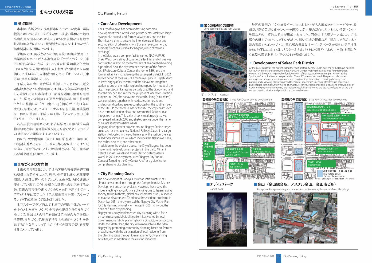
・ Core Area Development The City of Nagoya has been addressing core area development while introducing private-sector vitality on large-scale public-owned land, former railway sites, and the like. The initiative aims to ensure the intensive use of lands and accumulation of urban functions (for example commercial/business functions suitable for Nagoya, a hub of regional exchange). In the Sakae area, a complex facility named NADYA PARK (Naka Ward) consisting of commercial facilities and offices was constructed in 1996 on the former site of an abolished evening high school. Also, the city switched the sites of the former Aichi Prefecture Cultural Center, the former NHK, and the former Sakae Park to redevelop the Sakae park district. In 2002, service began at the Oasis 21 a multi-layer park in Higashi Ward. In 1989, Nagoya City constructed the Kanayama integrated station as one of the major regional transportation nodes of the city. The project in Kanayama partially used the city-owned land that the city had secured for the purpose of war reconstruction projects. In 1999, the Kanayama Minami building (Naka Ward) was completed together with roads, a station plaza and underground parking spaces constructed on the southern part of the site. On the norhern side of the site, the city constructed a bus terminal, station plaza, and commercial facilities in an integrated manner. This series of construction projects was completed in March 2005 and strated service under the name of Asunal Kanayama (Naka Ward). Ongoing development projects around Nagoya Station target areas such as the Japanese National Railways Sasashima cargo station site located in the southern area of the station, the area called “Sasashima Live 24” which includes the Nakagawa Canal, the harbor next to it, and other areas. In addition to the projects above, the City of Nagoya has been implementing development projects in the Daiko Minami district (Higashi Ward) and Atsuta Station district (Atsuta Ward). In 2004, the city formulated "Nagoya City Future Concept Targeting the City Center Area" as a guideline for comprehensive city planning.
・ City Planning GoalsThe development of Nagoya City urban infrastructure has almost been completed through the Comprehensive Districts Development and other projects. However, these days, the issues affecting Nagoya City are changing due to Japan’s aging society, falling birthrate, global environmental issues, response to massive disasters, etc. To address these various problems, in December 2011, the city revised the Nagoya City Master Plan for City Planning originally formulated in 2001 to lay out the goals of future city planning. Nagoya previously implemented city planning with a focus on constructing public facilities (i.e. initiatives led by local governments) and city planning from a big-picture perspective. Under the Master Plan, the city will aim to achieve the “Ideal Nagoya” by promoting community planning based on features of each area, with the participation of local residents from the planning stage through to management, city planning activities, etc. in addition to the existing initiatives.
■拠点開発
本市は、広域交流の拠点都市にふさわしい商業・業務機能をはじめとするさまざまな都市機能の集積と土地の高度利用を図るため、都心における大規模な公有地や鉄道跡地などにおいて、民間活力の導入をすすめながら拠点開発に取り組んでいます。
栄地区では、廃校となった夜間高校の跡地を活用して商業施設やオィスが入る複合施設「ナディアパーク」(中区)が平成8 年に完成しました。また旧愛知県文化会館、旧NHKと旧栄公園の敷地を入れ替え栄公園地区を再整備し、平成14 年に、立体型公園である「オアシス21」( 東区) の供用を開始しました。
平成元年に金山総合駅を整備し、市内有数の広域交通結節点となった金山地区では、戦災復興事業の用地として確保してきた市有地の一部等を活用し整備を進めました。駅南では隣接する道路や駅前広場、地下駐車場とともに整備した 「金山南ビル」(中区)が平成11 年に完成し、駅北では、バスターミナルや駅前広場、商業施設を一体的に整備し、平成17 年3月に「アスナル金山」(中区)がオープンしました。
名古屋駅周辺地区では、名古屋駅南の旧国鉄笹島貨物駅跡地と中川運河船だまり周辺を含むささしまライブ24 地区などで開発をすすめています。
他にも、大幸南地区(東区)、熱田駅前地区(熱田区)の開発を進めてきました。 また、都心部においては平成16 年に、総合的なまちづくりの指針となる「名古屋市都心部将来構想」を策定しています。
■まちづくりの方向性 本市の都市基盤については地区総合整備等を経て概
ね整備されてきましたが、近年、少子高齢化や地球環境問題、大規模災害への対応など、本市を取りまく課題が変化しています。こうした様々な課題への対応をするため、将来の都市像やまちづくりの方向性を示すものとして平成13 年に策定した「名古屋市都市計画マスタープラン」を平成23 年12月に改定しました。
本マスタープランでは、これまでの行政主体のハードを中心としたまちづくりや全市的な視点からのまちづくりに加え、地域ごとの特色を踏まえて地域の方が計画から管理、まちづくり活動まで行う「地域まちづくり」を推進することなどによって「めざすべき都市の姿」を実現することとしています。
■栄公園地区の開発 Development of Sakae Park District
■ナディアパーク
NADYA PARK
■金山(金山総合駅、アスナル金山、金山南ビル)Kanayama (Kanayama integrated station, Asunal Kanayama, Kanayama Minami building)
地区の東側の「文化施設ゾーン」には、NHK が名古屋放送センタービルを、愛知県が愛知芸術文化センターを建設し、名古屋の都心にふさわしい情報・文化・放送などの中枢的な拠点が形成されました。 西側の「広場ゾーン」については、都心の魅力の向上、にぎわいの創出、憩いの場の提供など「都心にきらめく水と緑の宝箱」をコンセプトに、都心部の貴重なオープンスペースを有効に活用するため、地下に広場、店舗、バスターミナル、地上に公園や「水の宇宙船」を配した立体型公園である 「オアシス21」を整備しました。
◦ Development of Sakae Park DistrictAt the eastern part of the district called the “cultural facility zone”, NHK built the NHK Nagoya building while Aichi Prefecture constructed the Aichi Arts Center, making the area a hub for information, culture, and broadcasting suitable for downtown of Nagoya. At the western part known as the “park zone”, a multi-layer urban park called “Oasis 21” was constructed. The park consists of an underground square, shopping arcade, and bus terminal, in addition to having above-ground parking and a viewing platform named the “Water spaceship” to ensure effective use of precious public space in the downtown area. The Oasis 21 construction concept is “a sparkling treasure box of water and greenery downtown”, and includes goals like improving the attractive features of the city center, creating vitality, and providing a comfortable area.
オアシス 21 Oasis 21