manual gps sunavi
TRANSCRIPT
晟航行动运算股份有限公司
Sunavi Mobile Computing Co.,Ltd.
1
User Manual for GPS Navigation System
Contents Chapter 1 Special Notice...........................................2
Chapter 2 Software Activation......................................2
Chapter 3 Menu Introduction .......................................3
Chapter 4 Destination Query......................................7
Chapter 5 Facilities around Query .................................15
Chapter 6 My Favourites..........................................21
6.1 Address Book...........................................................................................21
6.2 Historic Records ......................................................................................21 Chapter 7 Setup .................................................22
7.1 Display Setup...........................................................................................22
7.2 Sound Setup ............................................................................................24
7.3 Navigation Setup .....................................................................................25
7.4 Electronic Dog Setup ..............................................................................26
7.5 Restore the Initial Setup .........................................................................27
7.6 Version Information .................................................................................27 Chapter 8 Satellite State ..........................................27
Chapter 9 Transportation Query..................................27
Chapter 10 Exit ..................................................27
PDF 檔案使用 "pdfFactory Pro" 試用版本建立 www.ahasoft.com.tw/FinePrint
晟航行动运算股份有限公司
Sunavi Mobile Computing Co.,Ltd.
2
Chapter 1 Special Notice
Security Notice:
1 The system shall not be operated in the driving, unless the vehicles are in the
completely stationary state.
2 The driver’s sight shall be kept straight ahead; the careless driving shall cause the
severe accidents and damages.
3 The map information can not be guaranteed to be perfectly accurate; the driving shall
be in line with the actual roads situations and the traffic rules.
4 The Guiding Rules may not accord with the actual roads situations, please ignore any
suggestions being possible to induce any dangers.
A information menu will occur firstly when the system is used, for the aim of reminding
the drivers that the GPS Navigation System is an auxiliary tools providing assistance for
the driving, yet not a management tools controlling the driving. If there is any discrepancy
between the system and the actual roads situations, the driving shall be conducted
according to the actual situations. The illegal behaviors and unsafe conducts shall not be
occurred in the utilization of the system.
Attention:
1 The satellitic signals can be received by the GPS Navigation System only when it is in
the open air or besides the windows through which the sky can be seen.
2 Please confirm the current satellite state of the CPS Navigation System which can
locate accurately only after more than three satellites are received.
Chapter 2 Software Activation
At the first start-up of the system, such words as “No Legal Authorization for the
Software” will be shown. Then the system enters into the activation menu automatically.
After user inputs the correct activation code, the navigation system can be used normally.
PDF 檔案使用 "pdfFactory Pro" 試用版本建立 www.ahasoft.com.tw/FinePrint

晟航行动运算股份有限公司
Sunavi Mobile Computing Co.,Ltd.
3
Chapter 3 Menu Introduction
Choose “Disagree” means you exit from the system, and choose “Read and Agree”
means that you enter into the GPS Navigation System. Then, the GPS Satellitic
Information can be read by the system. And after several minutes’ calculation (the time
depends on the satellitic signals receiving), appears on the map for representing
the present location of the user if the successful location is obtained; otherwise, shall appear on the map, just as indicated by Figure 1.
Figure 1
The user can conduct the following operations also:
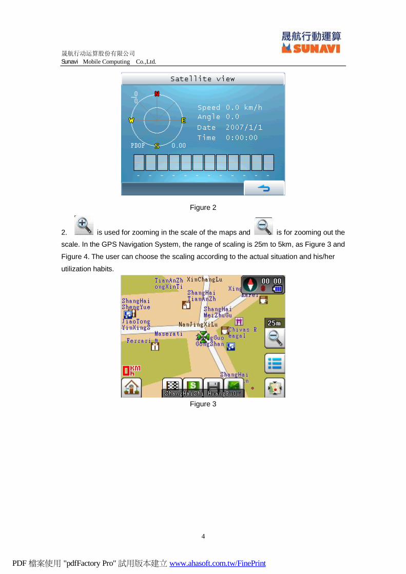
1. displays such information as North Arrow (the red point is for the
North), time, the number of satellites (different colors of the number stands for different
meanings: red for no location, yellow for the unstable location and the white for the stable
location) and electric quantity of the cells. Stroke the icon for displaying the present
satellite state, as Figure 2. (The satellitic signals can be received by the GPS Navigation
System only when it is in the open air or besides the windows through which the sky can
be seen. The menu of Figure 2 is for no signal.)
PDF 檔案使用 "pdfFactory Pro" 試用版本建立 www.ahasoft.com.tw/FinePrint
晟航行动运算股份有限公司
Sunavi Mobile Computing Co.,Ltd.
4
Figure 2
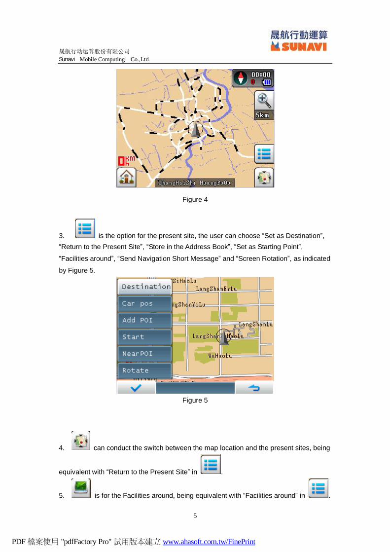
2. is used for zooming in the scale of the maps and is for zooming out the scale. In the GPS Navigation System, the range of scaling is 25m to 5km, as Figure 3 and
Figure 4. The user can choose the scaling according to the actual situation and his/her
utilization habits.
Figure 3
PDF 檔案使用 "pdfFactory Pro" 試用版本建立 www.ahasoft.com.tw/FinePrint
晟航行动运算股份有限公司
Sunavi Mobile Computing Co.,Ltd.
5
Figure 4
3. is the option for the present site, the user can choose “Set as Destination”, “Return to the Present Site”, “Store in the Address Book”, “Set as Starting Point”,
“Facilities around”, “Send Navigation Short Message” and “Screen Rotation”, as indicated
by Figure 5.
Figure 5
4. can conduct the switch between the map location and the present sites, being
equivalent with “Return to the Present Site” in .
5. is for the Facilities around, being equivalent with “Facilities around” in .
PDF 檔案使用 "pdfFactory Pro" 試用版本建立 www.ahasoft.com.tw/FinePrint

晟航行动运算股份有限公司
Sunavi Mobile Computing Co.,Ltd.
6
6 means being stored in the address book, being equivalent with “Store in the
Address Book” in .
7 indicates being set as the starting point, being equivalent with “Set as Starting
Point” in .
8. is being set as the destination, being equivalent with “Set as Destination” in
.
9. means entering into the Main Menu.
10. The option as “Send Navigation Short Message” in means the user can send the location short message to the others.
11. The option as “Screen Rotation” in means the user can rotate the screen as being horizontal or vertical.
PDF 檔案使用 "pdfFactory Pro" 試用版本建立 www.ahasoft.com.tw/FinePrint

晟航行动运算股份有限公司
Sunavi Mobile Computing Co.,Ltd.
7
Chapter 4 Destination Query
After is chosen, the Main Menu is obtained for providing seven menus as
“Destination Query”, “Facilities around”, “Short Message Navigation”, “My Favorites”,
“Setup”, “Satellite State”, “Transportation Query” and “Exit”. The user can query locations
through the first four menus. The differences are just that for “Destination Query” and
“Transportation Query”, the locations are provided by the system database and for “My
Favorites” and “Short Message Navigation”, the locations are defined by the users
themselves.
The Destination Query shall be introduced firstly and the other menus shall be
introduced one by one in the following.
Stroke “Destination Query” in the menu, there are four querying modes appeared as
“Facilities Query”, “Roads Query”, “Facilities Categories” and “Way Crossings”.
How to conduct destinations location and navigation by means of “Destination Query”
shall be then introduced.
Example 1: Locate Destination by “Facilities Categories”.
In this example, we make Emperor Hotel in Shenzhen, Guangdong Province as the
starting point.
After stroking and entering into the main menu, we choose “Destination
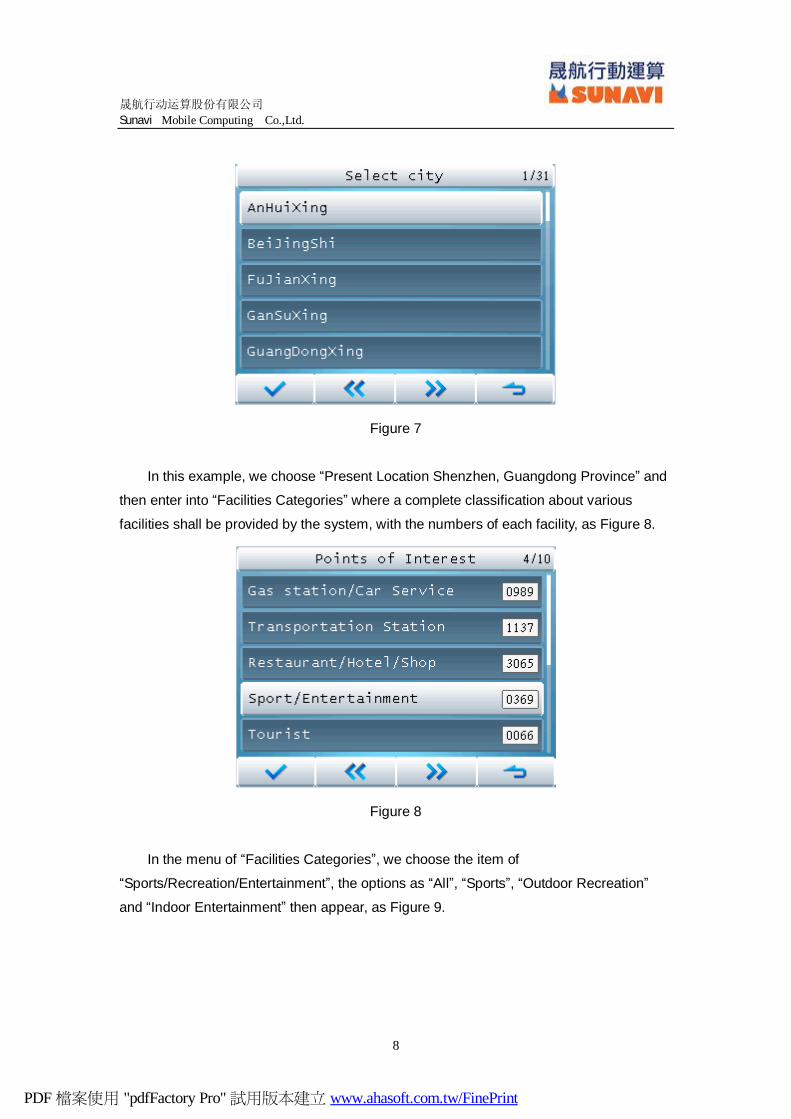
Query”----“Facilities Categories” and enter into the menu of “Choose City”. “Present
Location” refers to the cities we are located presently, as Figure 6. Choosing “All”, we will
have all the provinces and cities, as Figure 7.
Figure 6
PDF 檔案使用 "pdfFactory Pro" 試用版本建立 www.ahasoft.com.tw/FinePrint
晟航行动运算股份有限公司
Sunavi Mobile Computing Co.,Ltd.
8
Figure 7
In this example, we choose “Present Location Shenzhen, Guangdong Province” and
then enter into “Facilities Categories” where a complete classification about various
facilities shall be provided by the system, with the numbers of each facility, as Figure 8.
Figure 8
In the menu of “Facilities Categories”, we choose the item of
“Sports/Recreation/Entertainment”, the options as “All”, “Sports”, “Outdoor Recreation”
and “Indoor Entertainment” then appear, as Figure 9.
PDF 檔案使用 "pdfFactory Pro" 試用版本建立 www.ahasoft.com.tw/FinePrint
晟航行动运算股份有限公司
Sunavi Mobile Computing Co.,Ltd.
9
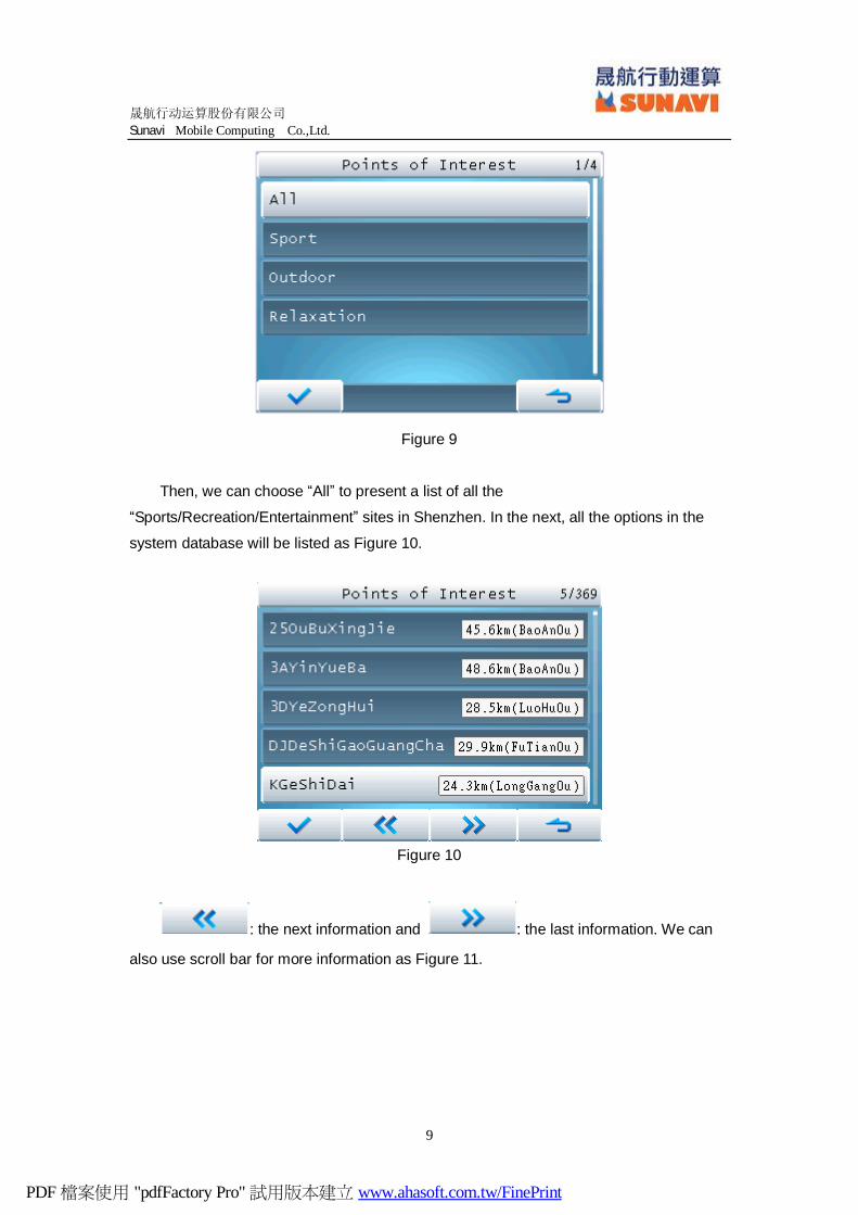
Figure 9
Then, we can choose “All” to present a list of all the
“Sports/Recreation/Entertainment” sites in Shenzhen. In the next, all the options in the
system database will be listed as Figure 10.
Figure 10
: the next information and : the last information. We can
also use scroll bar for more information as Figure 11.
PDF 檔案使用 "pdfFactory Pro" 試用版本建立 www.ahasoft.com.tw/FinePrint
晟航行动运算股份有限公司
Sunavi Mobile Computing Co.,Ltd.
10
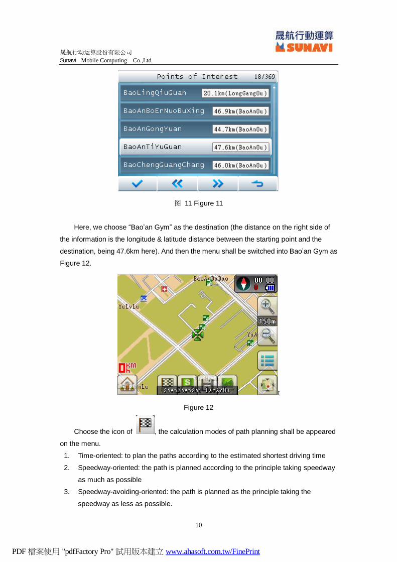
图 11 Figure 11
Here, we choose “Bao’an Gym” as the destination (the distance on the right side of
the information is the longitude & latitude distance between the starting point and the
destination, being 47.6km here). And then the menu shall be switched into Bao’an Gym as
Figure 12.
t
Figure 12
Choose the icon of , the calculation modes of path planning shall be appeared
on the menu.
1. Time-oriented: to plan the paths according to the estimated shortest driving time
2. Speedway-oriented: the path is planned according to the principle taking speedway
as much as possible
3. Speedway-avoiding-oriented: the path is planned as the principle taking the
speedway as less as possible.
PDF 檔案使用 "pdfFactory Pro" 試用版本建立 www.ahasoft.com.tw/FinePrint

晟航行动运算股份有限公司
Sunavi Mobile Computing Co.,Ltd.
11
4. Shortest Path: the path is planned as the shortest straight line distance.
Different transportation tools shall have different calculation modes.
1. Car Mode: having the modes as “Time-oriented”, “Speedway-oriented”,
“Speedway-avoiding-oriented” and “Shortest Path”.
2. Bicycle Mode and Walking Mode: having the modes as “Time-oriented” and
“Shortest Path”.
Here, we choose the tolerant “Time-oriented” to search the path. Then the occurred
green path is the planned navigation path, as Figure 13.
Figure 13
Choose the icon of or , the options as “Routes Showing”, “Routes Stimulation”, “Routes Canceling” and “Re-calculation” shall be displayed, as
Figure 14.
Figure 14
PDF 檔案使用 "pdfFactory Pro" 試用版本建立 www.ahasoft.com.tw/FinePrint
晟航行动运算股份有限公司
Sunavi Mobile Computing Co.,Ltd.
12
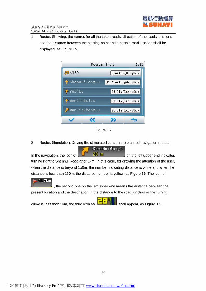
1 Routes Showing: the names for all the taken roads, direction of the roads junctions
and the distance between the starting point and a certain road junction shall be
displayed, as Figure 15.
Figure 15
2 Routes Stimulation: Driving the stimulated cars on the planned navigation routes.
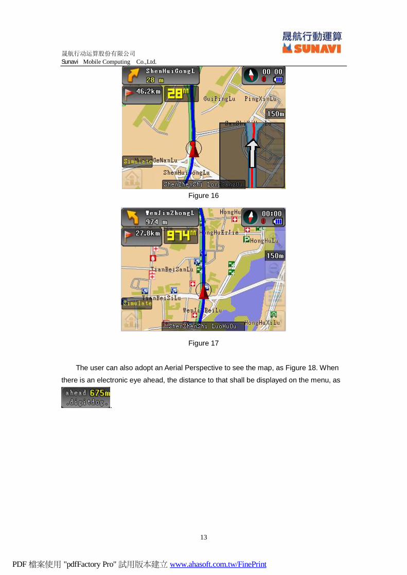
In the navigation, the icon of on the left upper end indicates turning right to Shenhui Road after 1km. In this case, for drawing the attention of the user,
when the distance is beyond 150m, the number indicating distance is white and when the
distance is less than 150m, the distance number is yellow, as Figure 16. The icon of
, the second one on the left upper end means the distance between the present location and the destination. If the distance to the road junction or the turning
curve is less than 1km, the third icon as shall appear, as Figure 17.
PDF 檔案使用 "pdfFactory Pro" 試用版本建立 www.ahasoft.com.tw/FinePrint
晟航行动运算股份有限公司
Sunavi Mobile Computing Co.,Ltd.
13
Figure 16
Figure 17
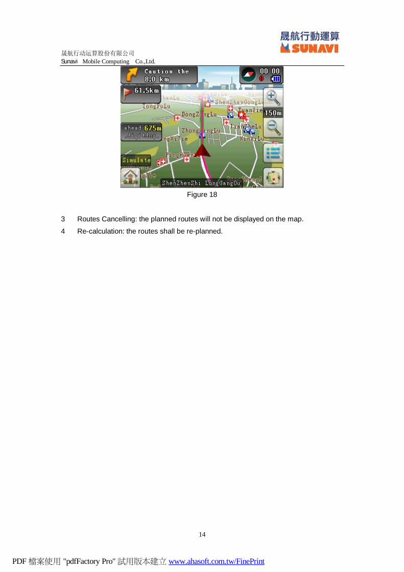
The user can also adopt an Aerial Perspective to see the map, as Figure 18. When
there is an electronic eye ahead, the distance to that shall be displayed on the menu, as
.
PDF 檔案使用 "pdfFactory Pro" 試用版本建立 www.ahasoft.com.tw/FinePrint
晟航行动运算股份有限公司
Sunavi Mobile Computing Co.,Ltd.
14
Figure 18
3 Routes Cancelling: the planned routes will not be displayed on the map.
4 Re-calculation: the routes shall be re-planned.
PDF 檔案使用 "pdfFactory Pro" 試用版本建立 www.ahasoft.com.tw/FinePrint

晟航行动运算股份有限公司
Sunavi Mobile Computing Co.,Ltd.
15
Chapter 5 Facilities around Query
Example 2: Locate the starting point through “Facilities around” and locate the
destination through “Way Crossings”.
The example takes Emperor Hotel in Shenzhen, Guangdong Province as the starting
point.
After choosing and entering into the main menu, we choose “Facilities
around”. Same with the “Facilities Categories”, the option will lead the user to choose the
facilities category and the concrete facility, as Figure 19 and Figure 20.
Figure 19
Figure 20
In the example, we choose “Industrial & Commercial/Residential Buildings” and its
option as “Living District”; then a list of all the facilities with the distance less than 30km to
PDF 檔案使用 "pdfFactory Pro" 試用版本建立 www.ahasoft.com.tw/FinePrint
晟航行动运算股份有限公司
Sunavi Mobile Computing Co.,Ltd.
16
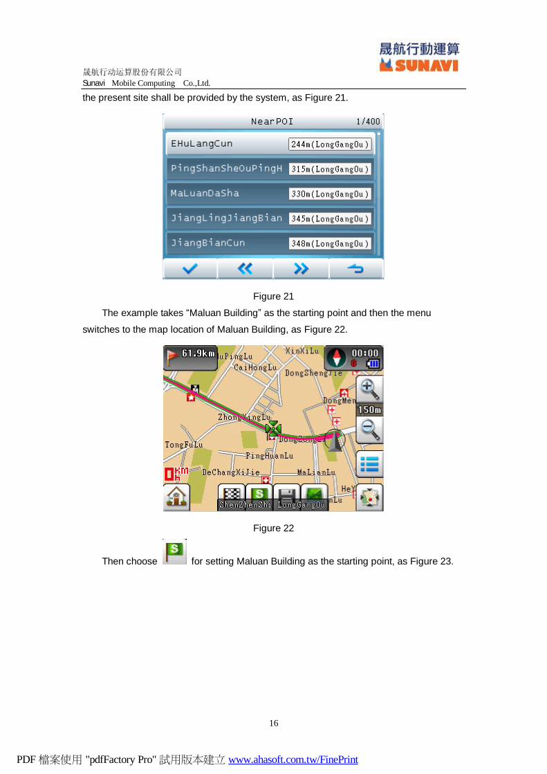
the present site shall be provided by the system, as Figure 21.
Figure 21
The example takes “Maluan Building” as the starting point and then the menu
switches to the map location of Maluan Building, as Figure 22.
Figure 22
Then choose for setting Maluan Building as the starting point, as Figure 23.
PDF 檔案使用 "pdfFactory Pro" 試用版本建立 www.ahasoft.com.tw/FinePrint
晟航行动运算股份有限公司
Sunavi Mobile Computing Co.,Ltd.
17
Figure 23
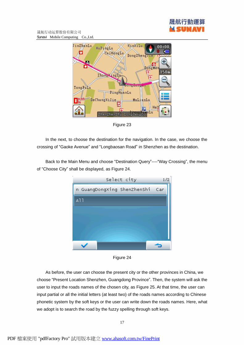
In the next, to choose the destination for the navigation. In the case, we choose the
crossing of “Gaoke Avenue” and “Longbaosan Road” in Shenzhen as the destination.
Back to the Main Menu and choose “Destination Query”----“Way Crossing”, the menu
of “Choose City” shall be displayed, as Figure 24.
Figure 24
As before, the user can choose the present city or the other provinces in China, we
choose “Present Location Shenzhen, Guangdong Province”. Then, the system will ask the
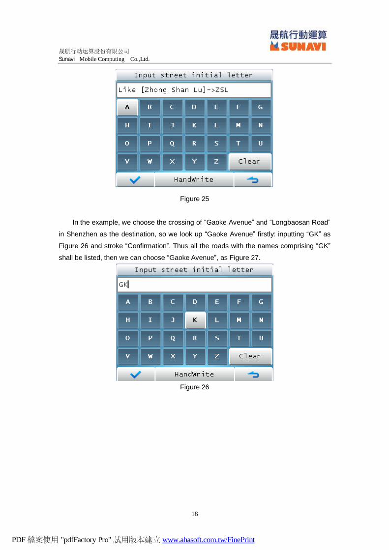
user to input the roads names of the chosen city, as Figure 25. At that time, the user can
input partial or all the initial letters (at least two) of the roads names according to Chinese
phonetic system by the soft keys or the user can write down the roads names. Here, what
we adopt is to search the road by the fuzzy spelling through soft keys.
PDF 檔案使用 "pdfFactory Pro" 試用版本建立 www.ahasoft.com.tw/FinePrint
晟航行动运算股份有限公司
Sunavi Mobile Computing Co.,Ltd.
18
Figure 25
In the example, we choose the crossing of “Gaoke Avenue” and “Longbaosan Road”
in Shenzhen as the destination, so we look up “Gaoke Avenue” firstly: inputting “GK” as
Figure 26 and stroke “Confirmation”. Thus all the roads with the names comprising “GK”
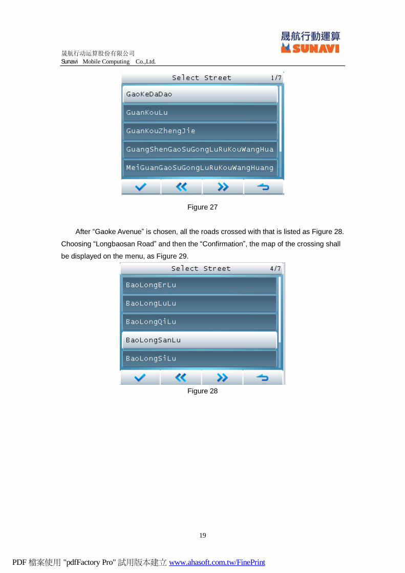
shall be listed, then we can choose “Gaoke Avenue”, as Figure 27.
Figure 26
PDF 檔案使用 "pdfFactory Pro" 試用版本建立 www.ahasoft.com.tw/FinePrint
晟航行动运算股份有限公司
Sunavi Mobile Computing Co.,Ltd.
19
Figure 27
After “Gaoke Avenue” is chosen, all the roads crossed with that is listed as Figure 28.
Choosing “Longbaosan Road” and then the “Confirmation”, the map of the crossing shall
be displayed on the menu, as Figure 29.
Figure 28
PDF 檔案使用 "pdfFactory Pro" 試用版本建立 www.ahasoft.com.tw/FinePrint
晟航行动运算股份有限公司
Sunavi Mobile Computing Co.,Ltd.
20
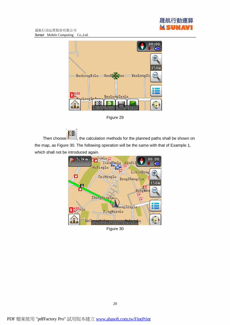
Figure 29
Then choose , the calculation methods for the planned paths shall be shown on
the map, as Figure 30. The following operation will be the same with that of Example 1,
which shall not be introduced again.
Figure 30
PDF 檔案使用 "pdfFactory Pro" 試用版本建立 www.ahasoft.com.tw/FinePrint
晟航行动运算股份有限公司
Sunavi Mobile Computing Co.,Ltd.
21
Chapter 6 My Favourites
Choose “My Favourites” in the Main Menu, the “Address Book” and “Historic Records”
shall be displayed.
6.1 Address Book
In the Map Mode, the user can record some location into the address book by
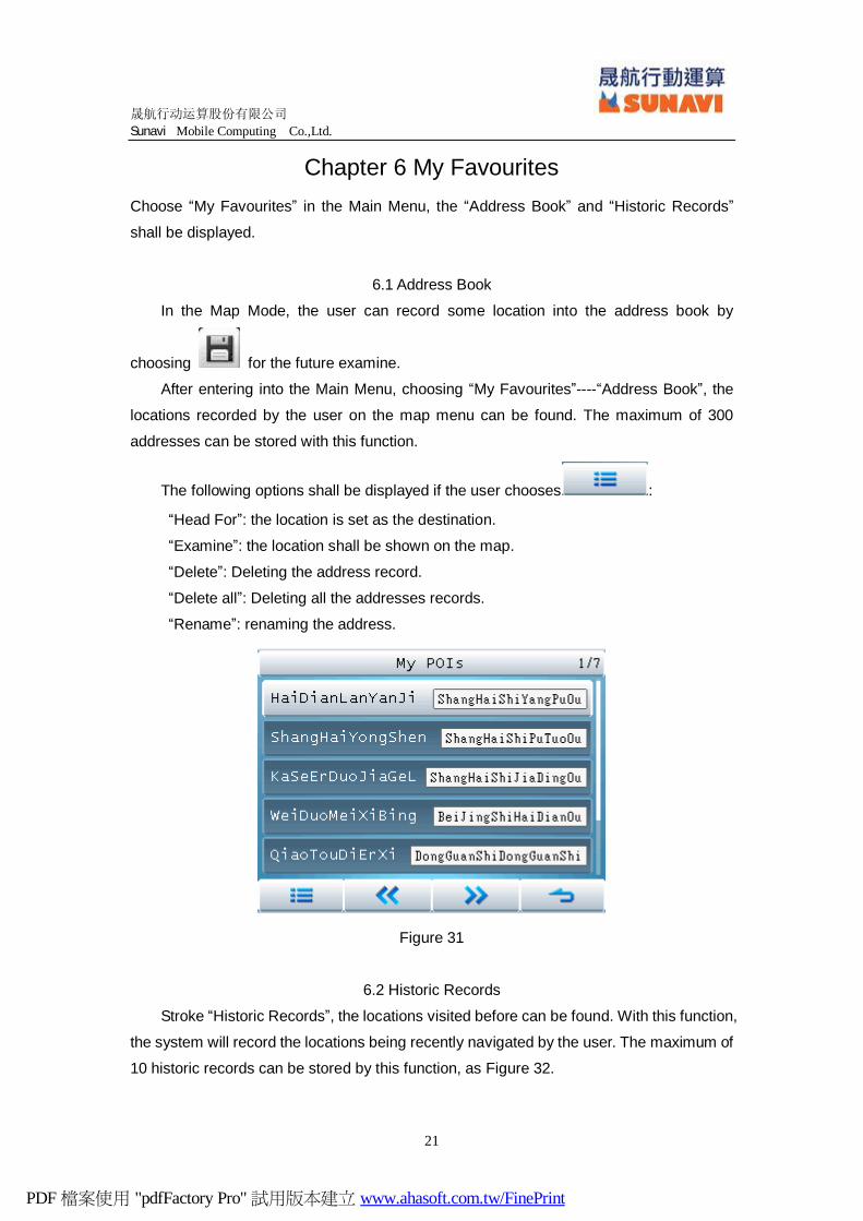
choosing for the future examine.
After entering into the Main Menu, choosing “My Favourites”----“Address Book”, the
locations recorded by the user on the map menu can be found. The maximum of 300
addresses can be stored with this function.
The following options shall be displayed if the user chooses :
“Head For”: the location is set as the destination.
“Examine”: the location shall be shown on the map.
“Delete”: Deleting the address record.
“Delete all”: Deleting all the addresses records.
“Rename”: renaming the address.
Figure 31
6.2 Historic Records
Stroke “Historic Records”, the locations visited before can be found. With this function,
the system will record the locations being recently navigated by the user. The maximum of
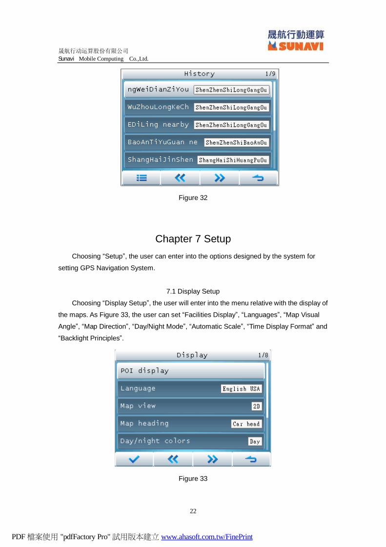
10 historic records can be stored by this function, as Figure 32.
PDF 檔案使用 "pdfFactory Pro" 試用版本建立 www.ahasoft.com.tw/FinePrint
晟航行动运算股份有限公司
Sunavi Mobile Computing Co.,Ltd.
22
Figure 32
Chapter 7 Setup Choosing “Setup”, the user can enter into the options designed by the system for
setting GPS Navigation System.
7.1 Display Setup
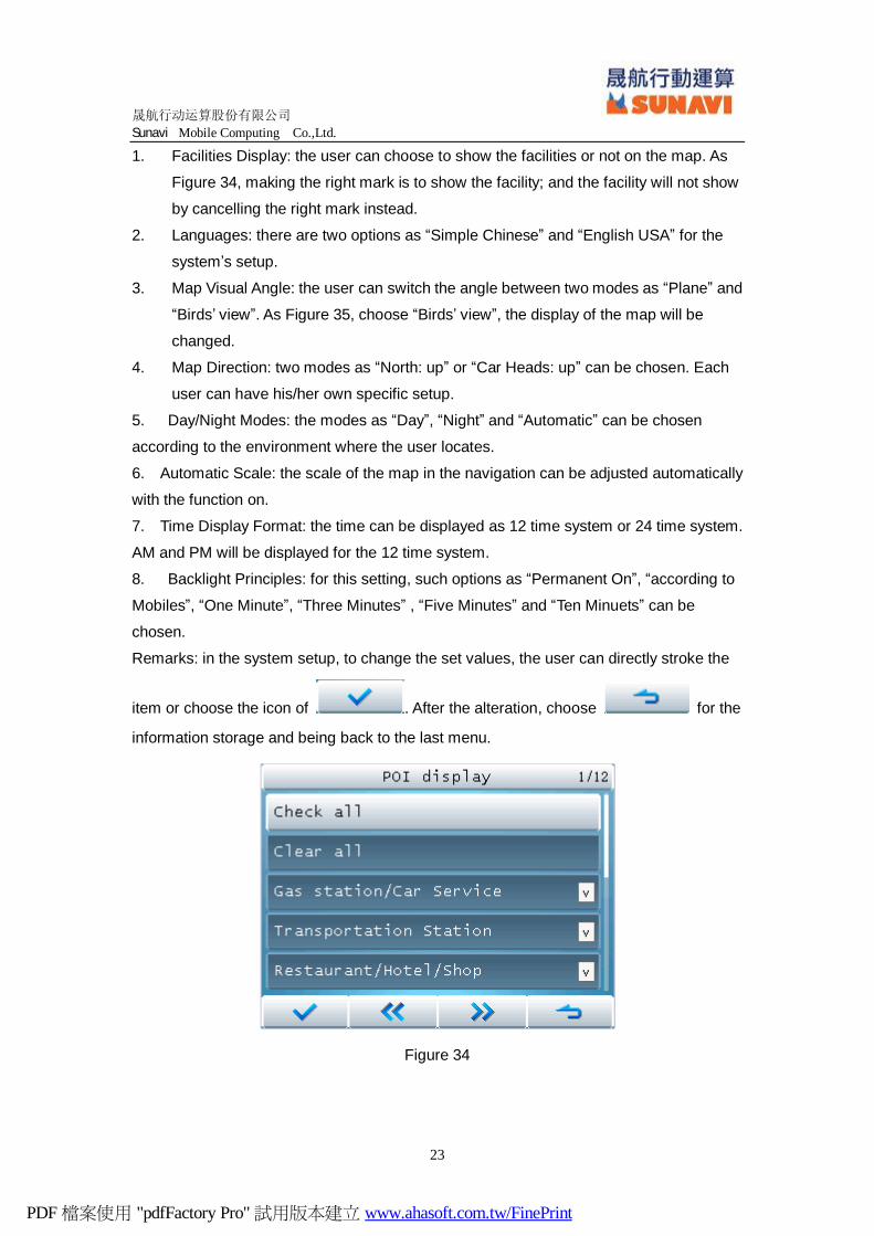
Choosing “Display Setup”, the user will enter into the menu relative with the display of
the maps. As Figure 33, the user can set “Facilities Display”, “Languages”, “Map Visual
Angle”, “Map Direction”, “Day/Night Mode”, “Automatic Scale”, “Time Display Format” and
“Backlight Principles”.
Figure 33
PDF 檔案使用 "pdfFactory Pro" 試用版本建立 www.ahasoft.com.tw/FinePrint
晟航行动运算股份有限公司
Sunavi Mobile Computing Co.,Ltd.
23
1. Facilities Display: the user can choose to show the facilities or not on the map. As
Figure 34, making the right mark is to show the facility; and the facility will not show
by cancelling the right mark instead.
2. Languages: there are two options as “Simple Chinese” and “English USA” for the
system’s setup.
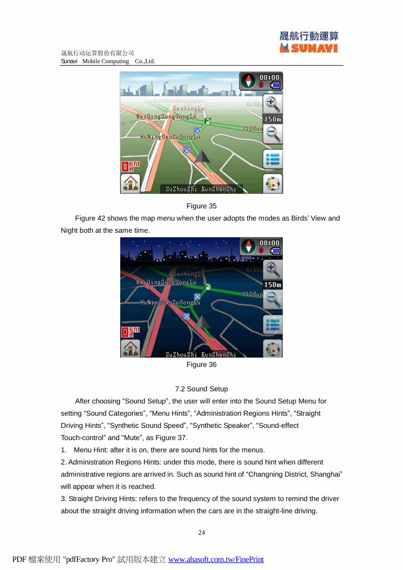
3. Map Visual Angle: the user can switch the angle between two modes as “Plane” and
“Birds’ view”. As Figure 35, choose “Birds’ view”, the display of the map will be
changed.
4. Map Direction: two modes as “North: up” or “Car Heads: up” can be chosen. Each
user can have his/her own specific setup.
5. Day/Night Modes: the modes as “Day”, “Night” and “Automatic” can be chosen
according to the environment where the user locates.
6. Automatic Scale: the scale of the map in the navigation can be adjusted automatically
with the function on.
7. Time Display Format: the time can be displayed as 12 time system or 24 time system.
AM and PM will be displayed for the 12 time system.
8. Backlight Principles: for this setting, such options as “Permanent On”, “according to
Mobiles”, “One Minute”, “Three Minutes” , “Five Minutes” and “Ten Minuets” can be
chosen.
Remarks: in the system setup, to change the set values, the user can directly stroke the
item or choose the icon of . After the alteration, choose for the
information storage and being back to the last menu.
Figure 34
PDF 檔案使用 "pdfFactory Pro" 試用版本建立 www.ahasoft.com.tw/FinePrint
晟航行动运算股份有限公司
Sunavi Mobile Computing Co.,Ltd.
24
Figure 35
Figure 42 shows the map menu when the user adopts the modes as Birds’ View and
Night both at the same time.
Figure 36
7.2 Sound Setup
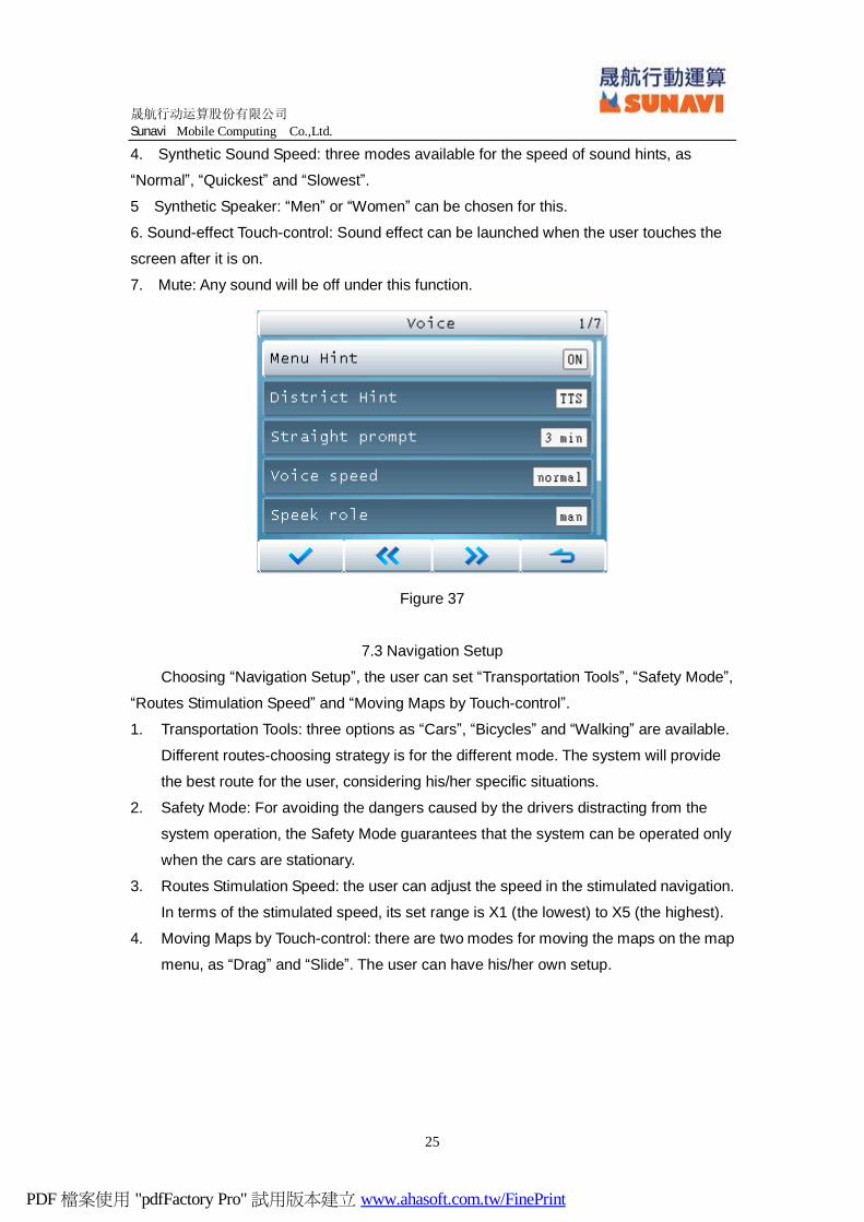
After choosing “Sound Setup”, the user will enter into the Sound Setup Menu for
setting “Sound Categories”, “Menu Hints”, “Administration Regions Hints”, “Straight
Driving Hints”, “Synthetic Sound Speed”, “Synthetic Speaker”, “Sound-effect
Touch-control” and “Mute”, as Figure 37.
1. Menu Hint: after it is on, there are sound hints for the menus.
2. Administration Regions Hints: under this mode, there is sound hint when different
administrative regions are arrived in. Such as sound hint of “Changning District, Shanghai”
will appear when it is reached.
3. Straight Driving Hints: refers to the frequency of the sound system to remind the driver
about the straight driving information when the cars are in the straight-line driving.
PDF 檔案使用 "pdfFactory Pro" 試用版本建立 www.ahasoft.com.tw/FinePrint
晟航行动运算股份有限公司
Sunavi Mobile Computing Co.,Ltd.
25
4. Synthetic Sound Speed: three modes available for the speed of sound hints, as
“Normal”, “Quickest” and “Slowest”.
5 Synthetic Speaker: “Men” or “Women” can be chosen for this.
6. Sound-effect Touch-control: Sound effect can be launched when the user touches the
screen after it is on.
7. Mute: Any sound will be off under this function.
Figure 37
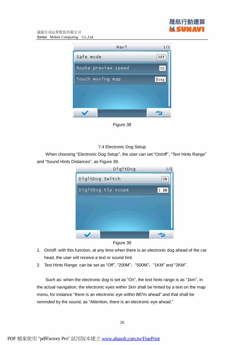
7.3 Navigation Setup
Choosing “Navigation Setup”, the user can set “Transportation Tools”, “Safety Mode”,
“Routes Stimulation Speed” and “Moving Maps by Touch-control”.
1. Transportation Tools: three options as “Cars”, “Bicycles” and “Walking” are available.
Different routes-choosing strategy is for the different mode. The system will provide
the best route for the user, considering his/her specific situations.
2. Safety Mode: For avoiding the dangers caused by the drivers distracting from the
system operation, the Safety Mode guarantees that the system can be operated only
when the cars are stationary.
3. Routes Stimulation Speed: the user can adjust the speed in the stimulated navigation.
In terms of the stimulated speed, its set range is X1 (the lowest) to X5 (the highest).
4. Moving Maps by Touch-control: there are two modes for moving the maps on the map
menu, as “Drag” and “Slide”. The user can have his/her own setup.
PDF 檔案使用 "pdfFactory Pro" 試用版本建立 www.ahasoft.com.tw/FinePrint
晟航行动运算股份有限公司
Sunavi Mobile Computing Co.,Ltd.
26
Figure 38
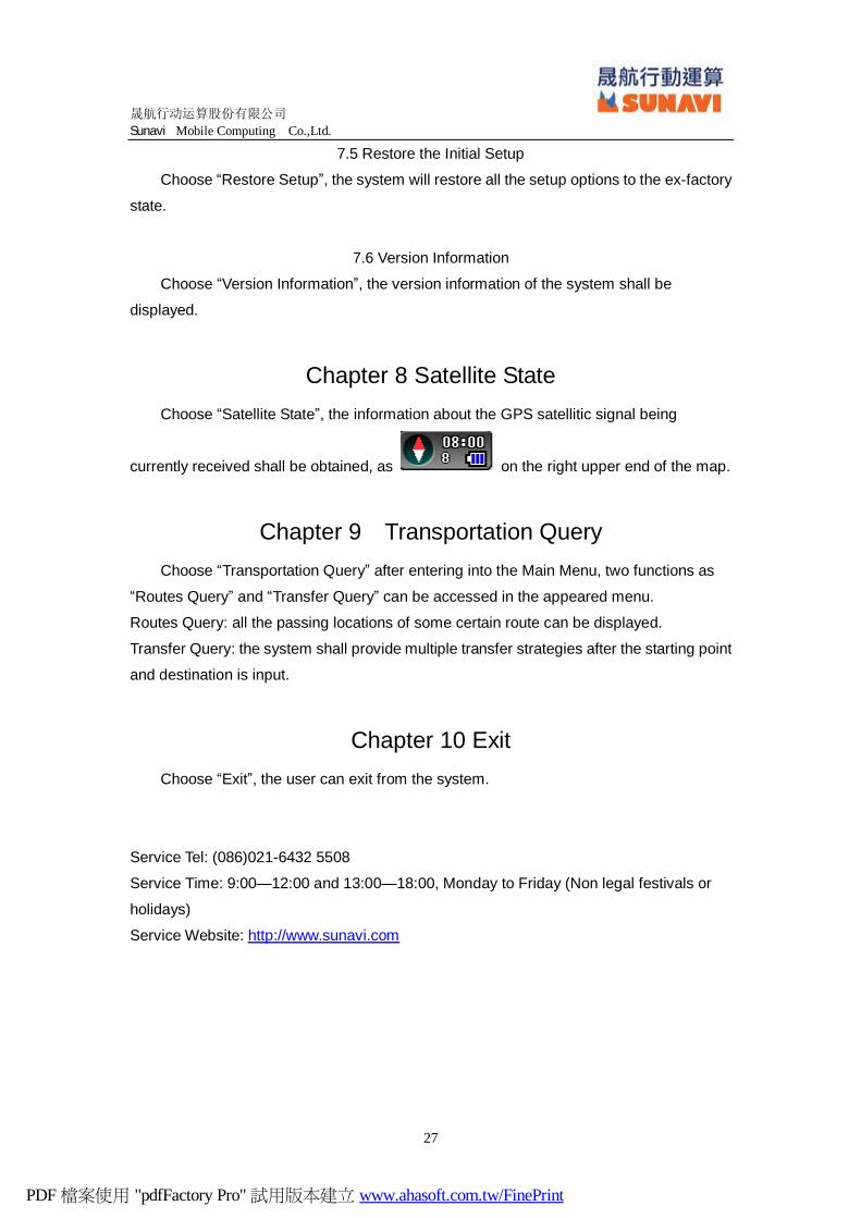
7.4 Electronic Dog Setup
When choosing “Electronic Dog Setup”, the user can set “On/off”, “Text Hints Range”
and “Sound Hints Distances”, as Figure 39.
Figure 39
1. On/off: with this function, at any time when there is an electronic dog ahead of the car
head, the user will receive a text or sound hint.
2. Text Hints Range: can be set as “Off”, “200M”,“500M”,“1KM” and “2KM”.
Such as: when the electronic dog is set as “On”, the text hints range is as “1km”, in
the actual navigation, the electronic eyes within 1km shall be hinted by a text on the map
menu, for instance “there is an electronic eye within 887m ahead” and that shall be
reminded by the sound, as “Attention, there is an electronic eye ahead.”
PDF 檔案使用 "pdfFactory Pro" 試用版本建立 www.ahasoft.com.tw/FinePrint
晟航行动运算股份有限公司
Sunavi Mobile Computing Co.,Ltd.
27
7.5 Restore the Initial Setup
Choose “Restore Setup”, the system will restore all the setup options to the ex-factory
state.
7.6 Version Information
Choose “Version Information”, the version information of the system shall be
displayed.
Chapter 8 Satellite State Choose “Satellite State”, the information about the GPS satellitic signal being
currently received shall be obtained, as on the right upper end of the map.
Chapter 9 Transportation Query Choose “Transportation Query” after entering into the Main Menu, two functions as
“Routes Query” and “Transfer Query” can be accessed in the appeared menu.
Routes Query: all the passing locations of some certain route can be displayed.
Transfer Query: the system shall provide multiple transfer strategies after the starting point
and destination is input.
Chapter 10 Exit Choose “Exit”, the user can exit from the system.
Service Tel: (086)021-6432 5508
Service Time: 9:00—12:00 and 13:00—18:00, Monday to Friday (Non legal festivals or
holidays)
Service Website: http://www.sunavi.com
PDF 檔案使用 "pdfFactory Pro" 試用版本建立 www.ahasoft.com.tw/FinePrint