mcconnells jest summary geological report
TRANSCRIPT

�1
Summary Geological Report for the
McConnells Jest Property, Yukon
Territory
Collaborative Authors: Fraser Kirk, Daniela Marcoux, Hanson Wong & Carrie Wong
Project Overseen By: Andrew Randell, PGeo
24th April 2015
Contents
1.0 Summary 3
2.0 Hive Introduc9on 4
3.0 Loca9on and Access 4 3.1 Accessibility 4 3.2 Infrastructure 4
4.0 Claim Informa9on 5
5.0 Physiography and Climate 6 5.1 Physiography 6 5.2 Climate 6
6.0 Property History 6
7.0 Geology 7 7.1 Regional Geology 7 7.2 Property Geology 10 7.3 MineralisaDon 11 7.4 StaDsDcs 11 7.4.1 Data PreparaDon 11 7.4.2 CorrelaDons 12 7.4.3 Principal Component Analysis (PCA) 13 7.5 Surficial Geology 15 7.6 Adjacent ProperDes 15
8.0 Explora9on Programs 17
9.0 Geochemical Analy9cal Procedure 19 9.1 2010 19 9.2 2011 20 9.3 2012 20 9.4 2014 21 9.5 QA / QC 21
10.0 Explora9on Results 22 10.1 Geochemical Evidence 22 10.2 Structural Elements 23 10.3 Rock Types 25 10.4 Revised Geology 27 10.5 InterpretaDon 28
11.0 Social Licence 29 11.1 First NaDons 29 11.2 Environmental Issues 30 11.3 Local PopulaDons 31
12.0 Recommenda9ons 31
13.0 References 35
Appendix 1: Team Details and Qualifica9ons 38 Appendix 2: Geochemical Cer9ficates 40 Appendix 3: Geochemical Maps -‐ Rocks 202 Appendix 4: Geochemical Maps -‐ Soils 209 Appendix 5: Other Maps 216 Appendix 6: Claims List 226
�2
1.0 Summary
The McConnell's Jest property, located in the central Yukon, lies 65 km northeast of Mayo, Y.T. Access to the property is limited to a 25 minute helicopter trip from the Mayo airstrip. The Hansen-‐McQuesten Lake road, which lies east of the property provides foot and skidoo access.
The McConnell Property consists of 172 conIguous (quartz) claims, owned 100% by Bill Koe-‐Carson, and covers an area of approximately 3,371 hectares. The property was under opIon with Golden Predator Canada Corp. but that agreement was terminated due to unrelated legal issues.
The property itself has seen limited exploraIon acIvity. The property was first staked by United Keno Hill Mines in the 1960’s, termed the “Zed” (Z) claims (Minfile#: 106D055). The property was subsequently staked in 2010 by Bill Koe-‐Carson. Golden Predator Canada Corp. oversaw soil and rock sampling programs in 2011 and 2012.
Mapping took place in 1961 (Green, 1972) by L. Green and the Geological Survey of Canada (GSC) as part of a helicopter-‐supported party known as the OperaIon Ogilvie (Minfile# 106D055). Directly south of the property, local topographic map sheet 105M was remapped by Roots (1997) of the GSC, and in 2003 the GSC released a geological compilaIon that included this area (Golden Predator Canada Corp., 2013).
The property underwent glaciaIon during the McConnell glaciaIon (>23,000 years ago; Bond, 1999). It has been demonstrated through a number of field seasons that the ground is covered by basal Ill. The lack of a disInct soil anomaly is agributed to the presence of loess deposits on the property.
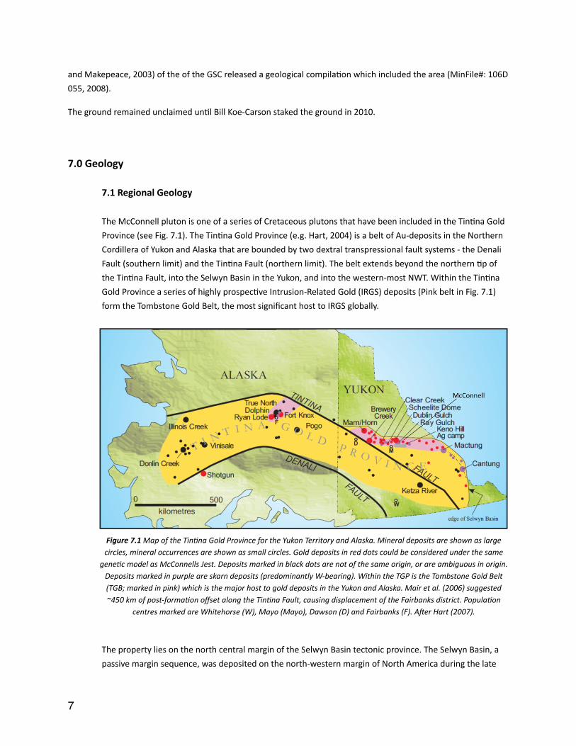
The McConnell pluton is one of a series of Cretaceous plutons that have been included in the TinIna Gold Province. The TinIna Gold Province (e.g. Hart, 2004) is a belt of Au-‐deposits in the Northern Cordillera of Yukon and Alaska that are bounded by two dextral transpressional fault systems -‐ the Denali Fault (southern limit) and the TinIna Fault (northern limit). The belt extends beyond the northern Ip of the TinIna Fault, into the Selwyn Basin in the Yukon, and into the western-‐most NWT. Within the TinIna Gold Province a series of highly prospecIve Intrusion-‐Related Gold (IRGS) deposits form the Tombstone Gold Belt, the most significant host to IRGS globally.
Paleozoic clasIc rocks of the upper Devonian and Mississippian Earn Group underlie the majority of the McConnell property. These metasedimentary sequences were formed in a submarine fan and channel deposit senng and subsequently deformed during Cordilleran tectonics. The 7 x 2.5 km McConnell pluton intrudes the Earn Group. The pluton is a mid-‐Cretaceous Tombstone suite granodiorite intrusion which occupies a large porIon of the property.
Two major mineral properIes lie adjacent to McConnells Jest, the Dublin Gulch IRGS deposit to the west and the Keno Hill silver district to the south east. Many similariIes exist between McConnells Jest and Dublin Gulch (6.3 M oz indicated and inferred, Wardrop Engineering Inc., 2011) and so the IRGS model has been adopted to describe mineralisaIon.
The basis of this report is to describe and draw conclusions from all previous exploraIon acIvity on the property. This report will address current understanding and look to provide new insight into the nature of mineralisaIon.
�3
AddiIonally, a series of cost-‐effecIve strategies in order to beger understand and expand mineral resources are proposed. All conclusions at this Ime should be considered preliminary.
2.0 Hive Introduc9on
This report has been compiled, researched and wrigen by SGDS Hive, which is a collaboraIve team of graduates and professionals. The informaIon in this report has been fact checked by Andy Randell P.Geo who also oversaw the project.
Note that this report does not consItute a NaIonal Instrument 43-‐101 as no site visit was conducted. Instead, this is a summary report that has consolidated data and made conclusions and recommendaIons from the informaIon available through the claim holder, government and other sources. The report does however follow the framework of a NI 43-‐101 layout to ensure maximum coverage and compleIon of the informaIon.
3.0 Loca9on & Access
3.1 Accessibility
The property is located in the central Yukon and lies 65 km northeast of Mayo, Y.T. on map sheet 106D03 and 105M14 at 479500m E and 7100000m N in NAD83 Zone 8 (Fig 3.1). The closest sizeable town is Mayo, located on the Stewart River, approximately 65 km to the southwest. Mayo is accessible from Whitehorse via a 460 km all-‐weather road and is also serviced by the Mayo airport, which is located just to the north of Mayo. Access to the property is limited to a 25 minute helicopter trip from the Mayo airstrip. The Hansen-‐McQuesten Lake road, which lies east of the property provides foot and skidoo access.
3.2 Infrastructure
Mayo has a populaIon of approximately 450 and offers accommodaIon, fuel, a nursing staIon, and earth-‐moving contractors. The Government of Yukon maintains a 1,400 m gravel airstrip, suitable for charter flights, about 3 km north of Mayo. There are no scheduled air services to Mayo. Local resources in terms of manpower, rental equipment, materials, and supplies are very limited.
A broader range of services is available in Whitehorse, Yukon, located about six hours by road to the south of the property. Whitehorse has a populaIon of 22,815 (NaIonal Household Survey, 2011) and has regularly scheduled air service to Vancouver, Edmonton, Calgary, and Fairbanks.
Electrical transmission lines from a hydroelectric facility near Mayo extend to the villages of Elsa and Keno City, about 20 km south of the property.
�4

� Figure 3.1 Map showing the boundary of the McConnells Jest claim block. Inset shows posiDon within the Yukon
Territory.
4.0 Claim Informa9on
Table 4.1 Claim informaDon for the McConnell's Jest property. Full details can be found in Appendix 6.
Claim Name Number(s) Grant Number Registered Owner
McConnells Jest 1 to 40 YD16701 to YD16740 Bill Koe-‐Carson -‐ 100%
McConnells Jest 41 to 52 YD54701 to YD54712 Bill Koe-‐Carson -‐ 100%
McConnells Jest 53 to 56 YD54713 to YD54716 Bill Koe-‐Carson -‐ 100%
McConnells Jest 57 to 120 YD54717 to YD54780 Bill Koe-‐Carson -‐ 100%
McConnells Jest 121 to 125 YD61470 to YD61474 Bill Koe-‐Carson -‐ 100%
McConnells Jest 126 -‐ 172 YD126853 -‐ YD126899 Bill Koe-‐Carson -‐ 100%
�5
5.0 Physiography and Climate
5.1 Physiography
The property is situated just southwest of the Davidson Range and McQuesten Lake. Topographically, the property lies in the bogom of the McQuesten Valley and is characterized by rolling hills and plateaus; elevaIon ranges from 640 m to 920 m above sea level. Relief on the property is moderately steep due to creek incising and hills that rise rapidly over lithology changes (Golden Predator Canada Corp., 2011). The property underwent glaciaIon during the McConnell glaciaIon (>23, 000 years ago; Bond, 1999), and it has been demonstrated through a number of field seasons that the ground is covered by basal Ill (Golden Predator Canada Corp., 2013). Outcrops are rare, generally less than two percent of the surface area, and are limited to ridge tops and creek walls. VegetaIon on the property consists of stunted spruce on north facing slopes and narrow valley floors, as well as slope alder. South facing slopes contain both coniferous trees and areas of deciduous aspen, poplar and birch. Patchy permafrost occurs on north-‐facing slopes (Golden Predator Canada Corp., 2011). It should be noted that an esImated 50% of the area has been burned in previous forest fires.
5.2 Climate
The central Yukon is characterized by a subarcIc conInental climate with cold winters and warm summers. The mean annual temperature for the area is approximately -‐3°C, with an annual range of 63.5°C. January is the coldest month, July the warmest. Average temperatures in the winter are between -‐15 and -‐20 degrees Celsius (°C) but can reach -‐60°C. The summers are moderately warm with average temperatures in July around 15°C. Annual precipitaIon ranges from 375 to 600 mm, about half of which falls as snow, which starts to accumulate in October and remains into May or June.
Because of its northern laItude, winter days are short with the sun low on the horizon such that north-‐facing slopes can experience ten weeks without direct sunlight around the winter solsIce. Conversely, summer days are very long, especially in early summer around the summer solsIce. ExploraIon and mining work can be carried out year-‐round.
6.0 Property History
There are no historical quartz claims recorded in the immediate vicinity of the property. However, based on the Minfile occurrence report for “Zed” (106D 055), United Keno Hill Mines had some ground over the current McConnells Jest claims. Throughout the 1960s and 1970s, United Keno Hill Mines carried out grid soil sampling and prospecIng on its claim groups including over the Zed occurrence. No significant mineralizaIon was recorded, and no assessment report was filed.
The area was regionally mapped (1:250,000) by L. Green (1972) of the GSC, and by C. Roots (1997) of the GSC, who remapped topographic map sheet 105 M located to the immediate south. In 2003, Gordey and Makepeace (Gordey
�6
and Makepeace, 2003) of the of the GSC released a geological compilaIon which included the area (MinFile#: 106D 055, 2008).
The ground remained unclaimed unIl Bill Koe-‐Carson staked the ground in 2010.
7.0 Geology
7.1 Regional Geology
The McConnell pluton is one of a series of Cretaceous plutons that have been included in the TinIna Gold Province (see Fig. 7.1). The TinIna Gold Province (e.g. Hart, 2004) is a belt of Au-‐deposits in the Northern Cordillera of Yukon and Alaska that are bounded by two dextral transpressional fault systems -‐ the Denali Fault (southern limit) and the TinIna Fault (northern limit). The belt extends beyond the northern Ip of the TinIna Fault, into the Selwyn Basin in the Yukon, and into the western-‐most NWT. Within the TinIna Gold Province a series of highly prospecIve Intrusion-‐Related Gold (IRGS) deposits (Pink belt in Fig. 7.1) form the Tombstone Gold Belt, the most significant host to IRGS globally.
�Figure 7.1 Map of the TinDna Gold Province for the Yukon Territory and Alaska. Mineral deposits are shown as large circles, mineral occurrences are shown as small circles. Gold deposits in red dots could be considered under the same
geneDc model as McConnells Jest. Deposits marked in black dots are not of the same origin, or are ambiguous in origin. Deposits marked in purple are skarn deposits (predominantly W-‐bearing). Within the TGP is the Tombstone Gold Belt (TGB; marked in pink) which is the major host to gold deposits in the Yukon and Alaska. Mair et al. (2006) suggested ~450 km of post-‐formaDon offset along the TinDna Fault, causing displacement of the Fairbanks district. PopulaDon
centres marked are Whitehorse (W), Mayo (Mayo), Dawson (D) and Fairbanks (F). Ader Hart (2007).
The property lies on the north central margin of the Selwyn Basin tectonic province. The Selwyn Basin, a passive margin sequence, was deposited on the north-‐western margin of North America during the late
�7
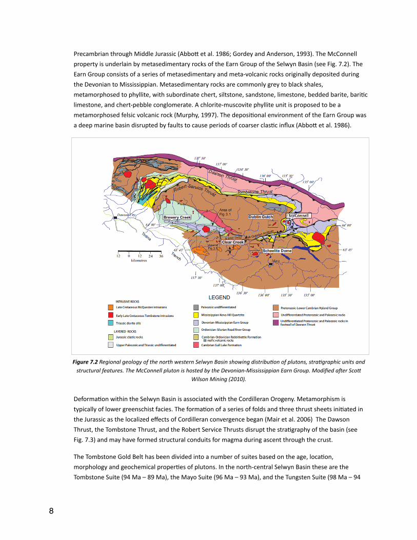
Precambrian through Middle Jurassic (Abbog et al. 1986; Gordey and Anderson, 1993). The McConnell property is underlain by metasedimentary rocks of the Earn Group of the Selwyn Basin (see Fig. 7.2). The Earn Group consists of a series of metasedimentary and meta-‐volcanic rocks originally deposited during the Devonian to Mississippian. Metasedimentary rocks are commonly grey to black shales, metamorphosed to phyllite, with subordinate chert, siltstone, sandstone, limestone, bedded barite, bariIc limestone, and chert-‐pebble conglomerate. A chlorite-‐muscovite phyllite unit is proposed to be a metamorphosed felsic volcanic rock (Murphy, 1997). The deposiIonal environment of the Earn Group was a deep marine basin disrupted by faults to cause periods of coarser clasIc influx (Abbog et al. 1986).
� Figure 7.2 Regional geology of the north western Selwyn Basin showing distribuDon of plutons, straDgraphic units and structural features. The McConnell pluton is hosted by the Devonian-‐Mississippian Earn Group. Modified ader Scof
Wilson Mining (2010).
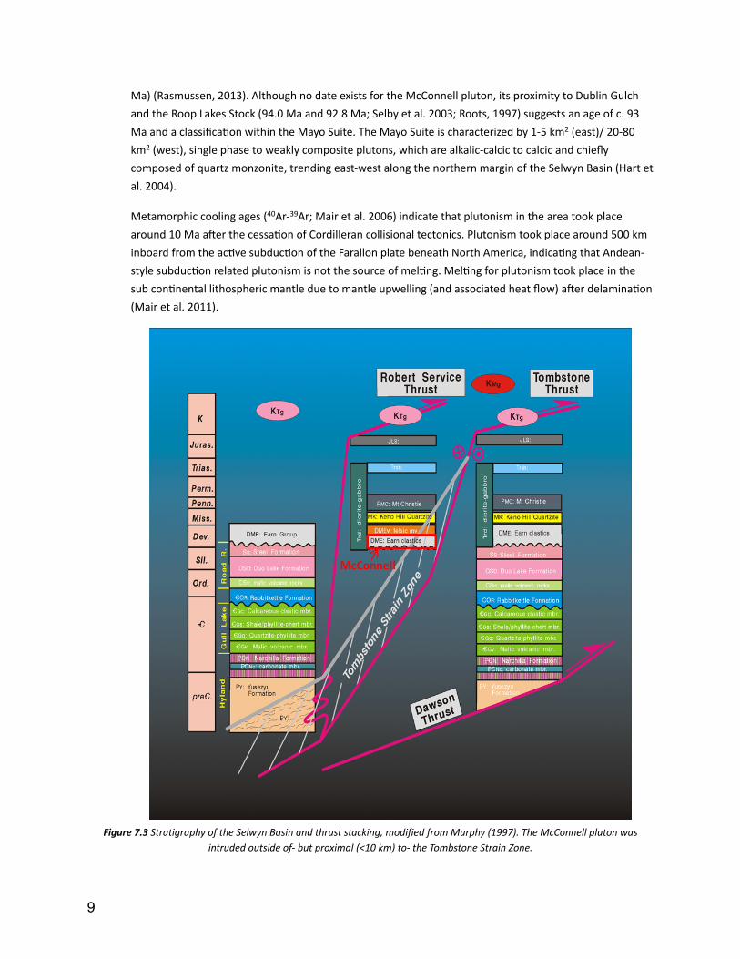
DeformaIon within the Selwyn Basin is associated with the Cordilleran Orogeny. Metamorphism is typically of lower greenschist facies. The formaIon of a series of folds and three thrust sheets iniIated in the Jurassic as the localized effects of Cordilleran convergence began (Mair et al. 2006) The Dawson Thrust, the Tombstone Thrust, and the Robert Service Thrusts disrupt the straIgraphy of the basin (see Fig. 7.3) and may have formed structural conduits for magma during ascent through the crust.
The Tombstone Gold Belt has been divided into a number of suites based on the age, locaIon, morphology and geochemical properIes of plutons. In the north-‐central Selwyn Basin these are the Tombstone Suite (94 Ma – 89 Ma), the Mayo Suite (96 Ma – 93 Ma), and the Tungsten Suite (98 Ma – 94
�8
Ma) (Rasmussen, 2013). Although no date exists for the McConnell pluton, its proximity to Dublin Gulch and the Roop Lakes Stock (94.0 Ma and 92.8 Ma; Selby et al. 2003; Roots, 1997) suggests an age of c. 93 Ma and a classificaIon within the Mayo Suite. The Mayo Suite is characterized by 1-‐5 km2 (east)/ 20-‐80 km2 (west), single phase to weakly composite plutons, which are alkalic-‐calcic to calcic and chiefly composed of quartz monzonite, trending east-‐west along the northern margin of the Selwyn Basin (Hart et al. 2004).
Metamorphic cooling ages (40Ar-‐39Ar; Mair et al. 2006) indicate that plutonism in the area took place around 10 Ma awer the cessaIon of Cordilleran collisional tectonics. Plutonism took place around 500 km inboard from the acIve subducIon of the Farallon plate beneath North America, indicaIng that Andean-‐style subducIon related plutonism is not the source of melIng. MelIng for plutonism took place in the sub conInental lithospheric mantle due to mantle upwelling (and associated heat flow) awer delaminaIon (Mair et al. 2011).
� Figure 7.3 StraDgraphy of the Selwyn Basin and thrust stacking, modified from Murphy (1997). The McConnell pluton was
intruded outside of-‐ but proximal (<10 km) to-‐ the Tombstone Strain Zone.
�9
�
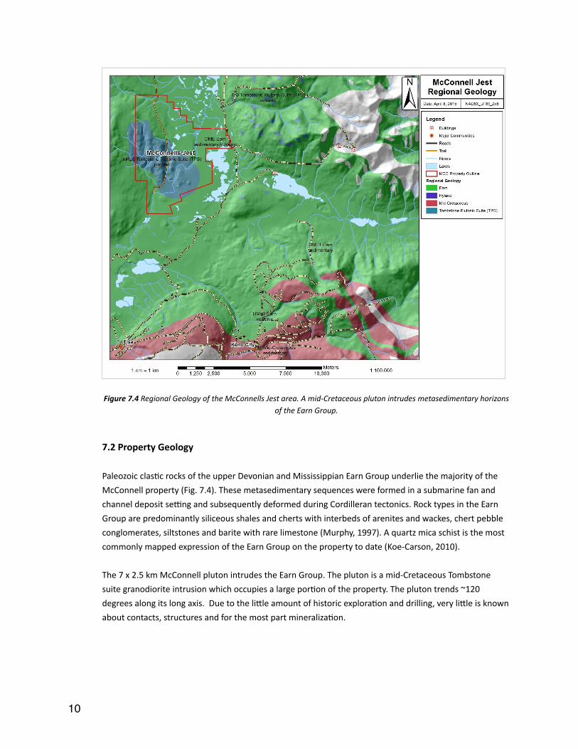
Figure 7.4 Regional Geology of the McConnells Jest area. A mid-‐Cretaceous pluton intrudes metasedimentary horizons of the Earn Group.
7.2 Property Geology
Paleozoic clasIc rocks of the upper Devonian and Mississippian Earn Group underlie the majority of the McConnell property (Fig. 7.4). These metasedimentary sequences were formed in a submarine fan and channel deposit senng and subsequently deformed during Cordilleran tectonics. Rock types in the Earn Group are predominantly siliceous shales and cherts with interbeds of arenites and wackes, chert pebble conglomerates, siltstones and barite with rare limestone (Murphy, 1997). A quartz mica schist is the most commonly mapped expression of the Earn Group on the property to date (Koe-‐Carson, 2010).
The 7 x 2.5 km McConnell pluton intrudes the Earn Group. The pluton is a mid-‐Cretaceous Tombstone suite granodiorite intrusion which occupies a large porIon of the property. The pluton trends ~120 degrees along its long axis. Due to the ligle amount of historic exploraIon and drilling, very ligle is known about contacts, structures and for the most part mineralizaIon.
�10
7.3 Mineraliza9on
Though the property is under-‐explored, an iniIal classificaIon within the intrusion-‐related gold system (IRGS) deposit model is suggested. Hart (2005) provides the following seven points as a summary of defining points for Intrusion-‐Related Gold Systems:
1. Metaluminous, sub-‐alkalic intrusion of intermediate to felsic composiIon, which are transiIonal between ilmenite and magneIte series.
2. Carbonic hydrothermal fluids responsible for mineralizaIon;
3. A metal assemblage that variably combines gold with elevated Bi, W, As, Mo,Te, and/or Sb and low concentraIons of base metals;
4. A low sulphide mineral content, mostly <5 vol%, with a reduced ore mineral assemblage that typically comprises arsenopyrite, pyrrhoIte and pyrite and lacks magneIte or hemaIte;
5. SpaIally-‐restricted, commonly weak hydrothermal alteraIon;
6. A tectonic senng well inboard of inferred or recognized convergent plate boundaries;
7. A locaIon in magmaIc provinces best or formerly known for tungsten and/or In deposits.
McConnells Jest saIsfies the regional geologic requirements of this model and early exploraIon work suggests that this model is the most appropriate. A parIally aligned stockwork of quartz veins, with potassic alteraIon selvedges, has been idenIfied in mulIple locaIons. AddiIonally, arsenopyrite veins associated with higher gold grades, with more pervasive clay alteraIon selvedges, are also present within the current sample set. The proximity and similarity of McConnells Jest to the adjacent Dublin Gulch, 6.3 M oz Au (Wardrop Engineering Inc., 2011), which is a holotypic example of an IRGS, further strengthens the case for this classificaIon. If further exploraIon clarifies the proposed IRGS classificaIon then gold can be geneIcally related to the intrusion of the McConnell pluton. Further, the areas of higher potenIal on the property will be those porIons of the pluton which are unroofed. Several examples of elevated tungsten exist in the sample set and suggest that exploraIon for a skarn deposit would be jusIfied.
7.4 Sta9s9cs
7.4.1 Data Prepara6on
Data was prepared for staIsIcal analysis by replacing values below detecIon with a zero value. Given the small sample set, values above detecIon were reset to the value represenIng the upper detecIon limit for inclusion. Data transformaIons were performed on an element by element basis in order to normalize the distribuIon of values, in order to saIsfy the requirement of normally distributed data for staIsIcal
�11
techniques. Data were either normalized using a natural logarithm (“_3” suffix in figures and tables) or a double natural logarithm (“_4” suffix in figures and tables) transformaIon.
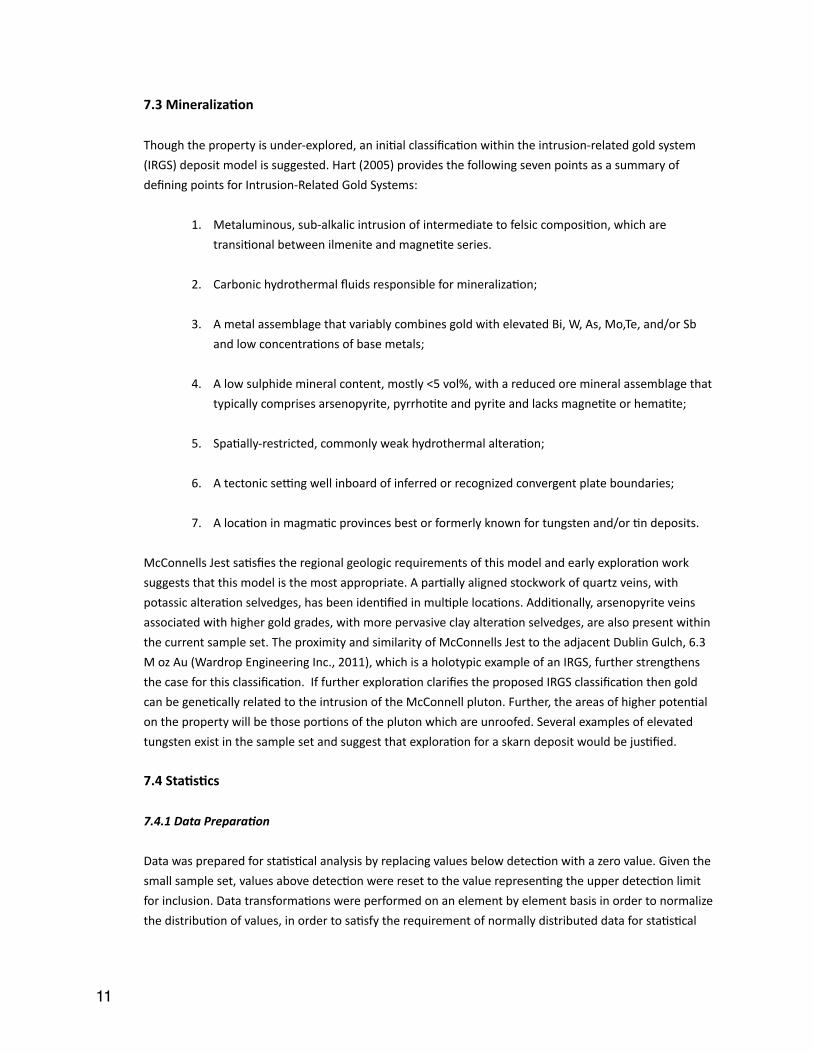
7.4.2 Correla6ons
A linear correlaIon was performed for 26 elements using the Pearson’s Product Moment CorrelaIon coefficient (Pearson, 1896). The Spearman’s Rank CorrelaIon Coefficient (Spearman, 1904), values are ranked and then a Pearsons CorrelaIon is performed on the ranked values. Ranking of the values can be useful for data which, even when transformed, is not enIrely normally distributed. Results vary between -‐1 and 1; a value of 1 represents a perfect posiIve correlaIon and a value of -‐1 represents a perfect negaIve correlaIon. A full set of correlaIon results are available in table 7.1 (Pearson) and 7.2 (Spearman).
Gold shows staIsIcally significant (≥0.70) correlaIons with Zn (0.98) using Pearson’s method and, K (0.83) and Ti (0.70) using Spearman’s method. The associaIon of Au with Zn may be due to co-‐precipitaIon of Au and Sphalerite ((Zn,Fe)S) during late-‐stage Au-‐Ag-‐Pb-‐Zn veins. The correlaIon between Au and K may point to a strong associaIon of gold within veins which have potassic (K-‐rich) alteraIon. The presence of hydrothermal ruIle (TiO2) in associaIon with gold and/or gold bearing minerals may be the cause for the correlaIon of Au with Ti. These associaIons should be confirmed with a mineralogical invesIgaIon of the property and should be considered as hypotheses only.
�
Table 7.1 Pearson’s CorrelaDon Coefficient for detected elemental concentraDons at McConnells Jest. Points of higher correlaDon (>0.59) are colour coded. Blue = 0.60 to 0.69, Green = 0.70 to 0.79, Orange = 0.80 to 0.89, Red = >0.90.
�12

�Table 7.2 Spearman’s Rank CorrelaDon Coefficient for detected elemental concentraDons at McConnells Jest. Points of higher correlaDon (>0.59) are colour coded. Blue = 0.60 to 0.69, Green = 0.70 to 0.79, Orange = 0.80 to 0.89, Red =
>0.90.
7.4.3 Principal Component Analysis (PCA)
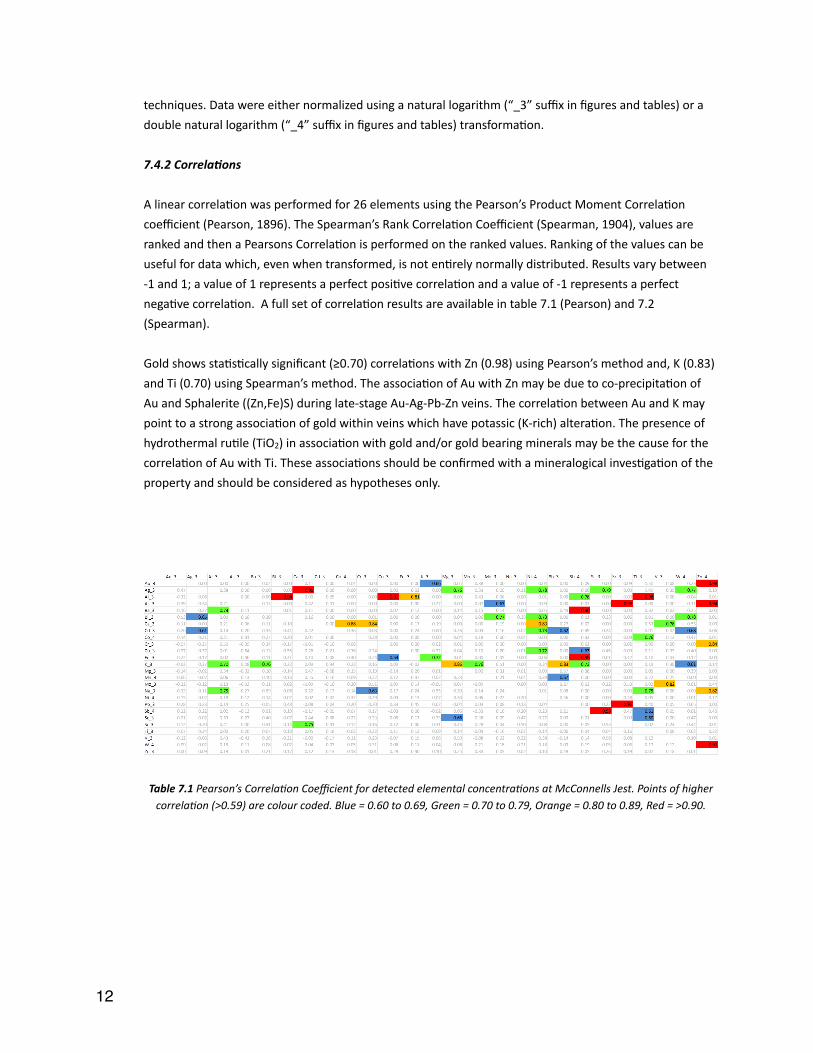
The suite of elements from assay data was split into two sets, 1) an “alteraIon” set (Al, Ba, Ca, Cr, K, Mg, Mn, Na, Sc,Sr, Ti, V), and 2) an “ore mineralizaIon” set (Au, Ag, As, Bi, Cd, Co, Cu, Fe, Mo, Ni, Pb, Sb, W, Zn) in order to most clearly portray these complementary aspects of the sample lithologies. Data used in the PCA was selected and transformed using the same criteria as for the element vs element correlaIons. The PAST sowware of Hammer et al. (2001) was used to carry out the PCA. These associaIons should be confirmed with a mineralogical invesIgaIon of the property and should be considered as hypotheses only.
AlteraIon Set (Fig 7.5): Three disInct grouping of elements are present:
1. Ti: Ti shows a large divergence from the rest of the elements within the alteraIon grouping. This may point to, as stated above, a hydrothermal ruIle (TiO2) phase.
2. MagmaIc (Al, Ba, Ca, K, Mg, Mn, Na, Sc, Sr, V): The close grouping of these elements is most likely explained by their dominant residence within the host rocks to mineralisaIon.
3. Cr: The proximity to the other magmaIc elements may point to the residence of Cr within intermediate dykes mapped on the property.
There is no clear pagern of associaIon of any of these elements with high grade gold values in Fig 7.5.
�13
� Figure 7.5 PCA Scafer plot for the alteraDon set of elements at McConnells Jest.
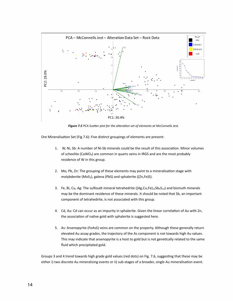
Ore MineralisaIon Set (Fig 7.6): Five disInct groupings of elements are present:
1. W, Ni, Sb: A number of Ni-‐Sb minerals could be the result of this associaIon. Minor volumes of scheelite (CaWO4) are common in quartz veins in IRGS and are the most probably residence of W in this group.
2. Mo, Pb, Zn: The grouping of these elements may point to a mineralisaIon stage with molybdenite (MoS2), galena (PbS) and sphalerite ((Zn,Fe)S).
3. Fe, Bi, Cu, Ag: The sulfosalt mineral tetrahedrite ((Ag,Cu,Fe)12Sb4S13) and bismuth minerals may be the dominant residence of these minerals. It should be noted that Sb, an important component of tetrahedrite, is not associated with this group.
4. Cd, Au: Cd can occur as an impurity in sphalerite. Given the linear correlaIon of Au with Zn, the associaIon of naIve gold with sphalerite is suggested here.
5. As: Arsenopyrite (FeAsS) veins are common on the property. Although these generally return elevated Au assay grades, the trajectory of the As component is not towards high Au values. This may indicate that arsenopyrite is a host to gold but is not geneIcally related to the same fluid which precipitated gold.
Groups 3 and 4 trend towards high grade gold values (red dots) on Fig. 7.6, suggesIng that these may be either i) two discrete Au mineralizing events or ii) sub-‐stages of a broader, single Au mineralisaIon event.
�14
An invesIgaIon into the hydrothermal paragenesis at McConnells Jest is required to test the above hypotheses.
� Figure 7.6 PCA Scafer plot for the mineralisaDon set of elements at McConnells Jest.
7.5 Surficial Geology
The property underwent glaciaIon during the McConnell glaciaIon (>23,000 years ago; Bond, 1999). It has been demonstrated through a number of field seasons that the ground is covered by basal Ill. Sampling of the property has been carefully completed, where possible, at sufficient depths (i.e. > 0.50 m) to avoid sampling possible shallow loess deposits. Generally, samples were collected at shallower depths (i.e. <0.3 m) in subalpine terrain with limited overburden or in boulder fields, as this was sufficient to avoid sampling glacial material (Golden Predator Canada Corp., 2013).
7.6 Adjacent Proper9es
Two major mineral properIes lie adjacent to McConnells Jest, the Dublin Gulch gold deposit to the west and the Keno Hill silver district to the south east (see Fig. 7.7). The Dublin Gulch and Keno Hill properIes are owned by Victoria Gold Corp. and Alexco Resources Corp., respecIvely.
�15
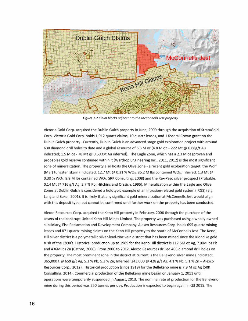
�Figure 7.7 Claim blocks adjacent to the McConnells Jest property.
Victoria Gold Corp. acquired the Dublin Gulch property in June, 2009 through the acquisiIon of StrataGold Corp. Victoria Gold Corp. holds 1,912 quartz claims, 10 quartz leases, and 1 federal Crown grant on the Dublin Gulch property. Currently, Dublin Gulch is an advanced-‐stage gold exploraIon project with around 630 diamond drill holes to date and a global resource of 6.3 M oz (4.8 M oz – 222 Mt @ 0.68g/t Au indicated; 1.5 M oz -‐ 78 Mt @ 0.60 g/t Au inferred). The Eagle Zone, which has a 2.3 M oz (proven and probable) gold reserve contained within it (Wardrop Engineering Inc., 2011, 2012) is the most significant zone of mineralizaIon. The property also hosts the Olive Zone -‐ a recent gold exploraIon target, the Wolf (Mar) tungsten skarn (Indicated: 12.7 Mt @ 0.31 % WO3, 86.2 M lbs contained WO3; Inferred: 1.3 Mt @ 0.30 % WO3, 8.9 M lbs contained WO3; SRK ConsulIng, 2008) and the Rex-‐Peso silver prospect (Probable: 0.14 Mt @ 716 g/t Ag, 3.7 % Pb; Hitchins and Orssich, 1995). MineralizaIon within the Eagle and Olive Zones at Dublin Gulch is considered a holotypic example of an intrusion-‐related gold system (IRGS) (e.g. Lang and Baker, 2001). It is likely that any significant gold mineralizaIon at McConnells Jest would align with this deposit type, but cannot be confirmed unIl further work on the property has been conducted.
Alexco Resources Corp. acquired the Keno Hill property in February, 2006 through the purchase of the assets of the bankrupt United Keno Hill Mines Limited. The property was purchased using a wholly-‐owned subsidiary, Elsa ReclamaIon and Development Company. Alexco Resources Corp. holds 695 quartz mining leases and 871 quartz mining claims on the Keno Hill property to the south of McConnells Jest. The Keno Hill silver district is a polymetallic silver-‐lead-‐zinc vein district that has been mined since the Klondike gold rush of the 1890’s. Historical producIon up to 1989 for the Keno Hill district is 117.5M oz Ag, 710M lbs Pb and 436M lbs Zn (Cathro, 2006). From 2006 to 2012, Alexco Resources drilled 405 diamond drill holes on the property. The most prominent zone in the district at current is the Bellekeno silver mine (Indicated: 365,000 t @ 659 g/t Ag, 5.3 % Pb, 5.3 % Zn; Inferred: 243,000 @ 428 g/t Ag, 4.1 % Pb, 5.1 % Zn – Alexco Resources Corp., 2012). Historical producIon (since 1919) for the Bellekeno mine is 7.9 M oz Ag (SRK ConsulIng, 2014). Commercial producIon of the Bellekeno mine began on January 1, 2011 unIl operaIons were temporarily suspended in August, 2013. The nominal rate of producIon for the Bellekeno mine during this period was 250 tonnes per day. ProducIon is expected to begin again in Q3 2015. The
�16

Lucky Queen, Flame & Moth, Onek and Bermingham occurrences provide addiIonal silver, lead and zinc resources. The deposit model of Hantelmann (2013) to describe mineralizaIon at Bellekeno is unlikely to occur at McConnells Jest, but cannot be enIrely ruled out unIl further work has taken place.
8.0 Explora9on Programs
In 2010 and with the assistance of a YMIP grant, Bill Koe Carson staked the property and collected 12 stream samples, 44 soil samples and 28 rock samples (Bourne, 2011). Stream sample MJSED-‐004 returned 11.7 ppm Au, MJSED-‐006 returned 0.558 ppm Au and MJSED-‐009 returned 0.305 ppm Au (Figure 2-‐2). Of the 28 rock samples, two had weakly anomalous gold assays in the 0.1 to 0.2 ppm range, however several samples contained anomalous pathfinder elements, for example 3722 ppm arsenic and 98 ppm bismuth in sample MJR-‐24.
In 2011, Golden Predator opIoned the ground and contracted All-‐In ExploraIon Inc. (Whitehorse, Yukon) to complete the collecIon of 380 soil samples from a grid covering the western secIon of the property. Samples were collected every 50m along east-‐west oriented lines 200m apart, to a total of 19.6km.
The results from this survey outlined several mulI-‐element geochemical anomalies, with sporadic highs (up to 208 ppb Au) and a cluster of elevated values (10 to 17 ppb Au) in the northeast quadrant. This anomaly is around 400m in length and lie within 500m of the anomalous stream sediments collected in 2010. This anomaly is associated with elevated levels of copper and arsenic.
In the southwest part of the grid, there is a strong cluster of arsenic anomalies that are associated with the highest gold result (208 ppb). There were also elevated levels of silver and bismuth in the same quadrant.
Work conInued in 2012 with a short field program undertaken again by Golden Predator.
A total of 74 rock samples were taken over the 3 day program on the McConnell claims. The program was undertaken by three geologists and an experienced prospector who has worked with Golden Predator for a number of years. Focus was put on intrusive rocks and sedimentary rocks proximal to those intrusions, as well as rocks which hosted sheeted quartz veins.
2012 work resulted in a number of interesIng anomalous targets which warrant follow up work (figures 8 and 9). Most notable is AA064560, a bedrock sample from a quartz-‐arsenopyrite breccia/vein which assayed over 25 g/t Au. With an orientaIon of 112 degrees azimuth, and a 38 degree dip, the sample shows a similarity to Dublin Gulch style structural extensional veining. In addiIon, a number of samples assaying over 0.3 g/t Au were discovered, and a soil sample which assayed 1.47 g/t Au at the north of the property were also discovered.
�17

�
Figure 8.1 Example of scorodite vein at surface. Sample AA064560 has an assay grade >25g/t Au.
It is understood that no work was undertaken in 2013 due to economic setbacks. Golden Predator did not return to the site, and the claim owner could not raise the cash to return to the property that year.
In 2014, the claim owner did return to the property, and with a small team collected 102 rock samples from across the property, in parIcular in the two anomalous areas previously idenIfied by Golden Predator in their soil program.
These rocks samples returned values up to 28.8ppm Au (sample 14474), with an addiIonal 16 samples returning grades in excess of 0.5ppm. Many of the samples were from sheeted veins or scorodite exposures within the two anomalous zones. These zones were subsequently named Bullion Blister (in the west) and Pink Mountain (in the east).
Pink Mountain has an abundance of sheeted vein systems, and covers an area approximately 500m by 375m (although this remains open on three sides). The grades here slightly lower but more consistent, around 1g/t Au.
Bullion Blister hosts many of the scorodite veins in oxidised rock, and as such has returned the highest assays, including the 28.8g/t.
�18

9.0 Geochemical Analy9cal Procedures
Geochemical analyses for samples from 2010 to 2014 are summarized in Table 9.1. A more detailed descripIon of the analyIcal techniques is presented below, split by the year of analysis.
Table 9.1 Geochemical AnalyDcal Procedures for 2010 to 2014. 9.1 2010
All samples from the 2010 field season were sent to Inspectorate Laboratories, Whitehorse, YT., Canada. A total of 37 rock (cerIficates: 10-‐360-‐00307 – 9 samples, 10-‐360-‐00309 – 28 samples), 44 soil (cerIficate: 10-‐360-‐03010) were analyzed for 30 elements using inducIvely coupled plasma emission spectroscopy (ICP-‐ES) package “30-‐4A-‐TR”. A 4-‐acid aqua regia digesIon was performed on a 0.5 g split of the sample and subsequently analyzed using ICP-‐ES.
Certificate Number
Lab Type Total Samples
Received Completed Method
10-360-02341 INSP Soil 2 26th July 2010 11th August 2010
Pd-1AT-ICP, Ag-1AT-GV, Au-1AT-AA, Ag-4A-OR, Pt-1AT-ICP
10-360-00307 INSP Rock 9 28th October 2010
10th December
2010
30-4A-TR
10-360-00308 INSP Moss 1 24th September
2010
4th October 2010
30-4A-TR
10-360-00309 INSP Rock 28 30th September
2010
12th October 2010
30-4A-TR
10-360-03010 INSP Soil 44 30th September
2010
19th October 2010
30-4A-TR, Au-1AT-AA
10-360-03200 INSP Pulp 37 13th October 2010
18th October 2010 Au-1AT-AA
WHI1101802 ACME Soil 320 24th October 2011
5th December
2011
ACM 1DX15
WHI1101803 ACME Soil 58 24th October 2011
5th December
2011
ACM 1DX15
12Y640856 AGAT Rock 78 - 19th October 2012
AGAT 201074
12Y640884 AGAT Soil 242 - 19th October 2012
AGAT 201074
WHI14000057 ACME Rock 102 24th July 2014 13th August 2014 FA430, AQ200, FA530
WHI14000057M ACME Metallic Screen
4 24th September
2014
8th October 2014
FS651, FA550-Au
�19
46 soil (cerIficates: 10-‐360-‐02341 – 2 samples, 10-‐360-‐03010 – 44 samples) and 37 pulp samples (cerIficate: 10-‐360-‐03200) were analyzed for gold using the “Au-‐1AT-‐AA” fire assay package. A lead collecIon fire assay fusion was made from 30 g of the sample for total sample decomposiIon. The resulIng silver dore was digested in acid and analyzed by atomic absorpIon spectroscopy (AAS).
PlaInum, Palladium and Silver were also tested for in 2 soil samples (cerIficate: 10-‐360-‐02341) using the “Pt-‐1AT-‐ICP”, “Pd-‐1AT-‐ICP” and, “Ag-‐1AT-‐GV” and “Ag-‐4A-‐OR”, respecIvely. For PlaInum and Palladium, A lead collecIon fire assay fusion was made from 50 g of the sample for total sample decomposiIon. The resulIng silver dore was digested in acid and analyzed by ICP-‐ES. For silver in the “Ag-‐1AT-‐GV” package, a lead collecIon fire assay fusion was made from 30 g of the sample for total sample decomposiIon. The resulIng silver dore was digested in acid and analyzed by gravimetric analysis. For “Ag-‐4A-‐OR” the sample was decomposed using a 4-‐acid digesIon and analyzed for silver using AAS.
9.2 2011
All samples from the 2011 field season were sent to ACME AnalyIcal Laboratories Ltd. in Whitehorse, YT., Canada. A total of 320 soil (cerIficate: WHI1101802) and 61 rock (cerIficate: WHI1101803) samples were analyzed using the “ACM 1DX15” package for 36 elements. Samples were dried at 60ºC, 100g of the sample was then sieved using an 80 mesh. Sample splits of 0.5 g are leached in hot modified aqua regia and analyzed using inducIvely coupled plasma mass spectrometry (ICP-‐MS).
9.3 2012
All samples from the 2012 field season were sent to AGAT ISO 9001 cerIfied lab in Whitehorse Y.T, Canada.. A total of 242 soil (cerIficate: 12Y640884) and 78 rock (cerIficate: 12Y640856) samples were analyzed using the “AGAT 201074” package.
Analysis was by aqua-‐regia digesIon and a mass spectrometer finish with a 52 metal analysis package. What follows are excerpts from the AGAT laboratory mining geochemistry package.
Samples were dried at 60 degrees cenIgrade, crushed to the point of 75% passing through a 2mm mesh, then split with a Jones riffler spliger or rotary split. The sample was then pulverized to the point of 85% passing through a 75 micrometer mesh. Finally, samples were screened awer drying, shaken on an 80 mesh sieve with the posiIve fracIon stored and the negaIve fracIon sent to the laboratory for analysis. This concludes the preparaIon porIon of sampling.
Prepared samples are digested with aqua regia for one hour using temperature controlled hot blocks. ResulIng digests are diluted with de-‐ionized water. Sample splits of 1 gram or rouInely used. These 1 gram samples are then ran through a mass spectrometer. Perkin Elmer 7300DV and 8300DV ICP-‐OES (OpIcal Emission Spectroscopy) and Perkin Elmer Elan 9000 and NexION ICP-‐MS (Mass Spectrometer) are used in analysis. Inter-‐Element CorrecIon (IEC) techniques are used to correct for any spectral interferences (Golden Predator Canada Corp., 2013).
�20
It should be noted that determinaIon of gold by this method is semi-‐quanItaIve due to small sample size. Samples with arsenic above detecIon (>10,000 ppm) were re-‐run using AAS.
9.4 2014
All samples from the 2014 field season were sent to ACME Labs in Whitehorse, YT., Canada. A total of 102 rock (cerIficate: WHI14000057) samples were analyzed using the “FA430” package for gold and “AQ200” package for a further 36 elements. Using the “FA430” package, a lead collecIon fire assay fusion was made from 30 g of the sample for total sample decomposiIon. The resulIng silver dore was digested in acid and analyzed by atomic absorpIon spectroscopy (AAS). For “AQ200”, Sample splits of 0.5 g are leached in hot modified aqua regia and analyzed using inducIvely coupled plasma mass spectrometry (ICP-‐MS). Gold samples >10 g/t were re-‐run using the “FA-‐530” package, where a lead collecIon fire assay fusion was made from 30 g of the sample for total sample decomposiIon. The resulIng silver dore was digested in acid and analyzed for by gravimetric analysis.
A sub-‐set of four samples (cerIficate: WHI14000057M) from the original 102 were selected for addiIonal metallic screening to test for gold using the “FS651” package. Samples underwent metallic pulverizing and a 500 g sample split was screened to 106 μm. Gravimetric analysis was performed on the plus fracIon and instrumentaIon on the minus fracIon. Two of the samples >10 g/t gold were re-‐run using the “FA550-‐Au” package; a lead collecIon fire assay fusion was made from 50 g of the sample for total sample decomposiIon. The resulIng silver dore was digested in acid and analyzed by gravimetric analysis.
9.5 QA/QC
All analyses were tested for accuracy and precision using a series of standardized materials, preparaIon duplicates and procedural blanks at the corresponding laboratories under their respecIve internal quality control protocol. Field blanks were inserted into soil analyses for 2011 and 2012 at a frequency of ~1 per 50 samples. Table 9.2 lists the standards used for each cerIficate.
�21

Table 9.2 Summary of geochemical standards used by laboratories.
10.0 Explora9on Results
The work so far seems to indicate that the McConnells Jest property is geologically very similar to that of Dublin Gulch, and thus has the potenIal to contain a significant deposit.
10.1 Geochemical Evidence
Through consolidaIng the geochemical data collected between 2011 and 2014, it becomes clear that there are several zones of interest (Fig. 10.1), although it should be remembered that the enIre property has not been covered, and so there is significant potenIal for other mineral zones.
The main area of interest lies along the SW-‐NE trending lineaIons (refer to secIon 10.2), where mulIple elements are in higher proporIons, including gold, silver, bismuth, arsenic and lead. These also coincide with veining observed and recorded in field notes. Around the edges of the pluton, there are several silver and silver-‐lead anomalies, which could represent either distal (and therefore cooler) systems, or overprinIng from Keno Hill style mineral veins.
On the southwestern side of the pluton, there seems to be some correlaIon to elevated tungsten levels, although the number of samples collected from this area are low so it is tough to draw conclusions.
This assemblage of elements is in line with the an Intrusion Related Gold System, and spaIally bears resemblance to the geochemical distribuIons of Dublin Gulch.
Certificate Number
Standard(s)
10-360-02341 STD-ME-6
10-360-00307 STD-ME-6
10-360-00308 No standard used
10-360-00309 STD-ME-6
10-360-03010 STD-ME-8, STD-OREAS-45P-4A, STD-Oxi67
10-360-03200 STD-Oxi67
WHI1101802 STD DS8
WHI1101803 STD DS8
12Y640856 Standard used but not referenced
12Y640884 Standard used but not referenced
WHI14000057 STD AGPROOF, STD DS10, STD OREAS45EA, STD OXD108, STD OXI121, STD OXN117, STD SP49
WHI14000057M STD AGPROOF, STD OXD108, STD OXI121, STD OXN117, STD OXP91, STD SP49, STD SQ70
�22
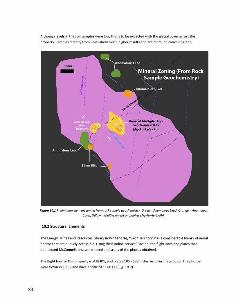
Although levels in the soil samples were low, this is to be expected with the glacial cover across the property. Samples directly from veins show much higher results and are more indicaIve of grade.
� Figure 10.1 Preliminary element zoning from rock sample geochemistry. Green = Anomalous Lead, Orange = Anomalous
Silver, Yellow = MulD-‐element anomalies (Ag-‐Au-‐As-‐Bi-‐Pb).
10.2 Structural Elements
The Energy, Mines and Resources Library in Whitehorse, Yukon Territory, has a considerable library of aerial photos that are publicly accessible. Using their online service, Skyline, the flight lines and plates that intersected McConnells Jest were noted and scans of the photos obtained.
The flight line for this property is ‘A28301, and plates 185 -‐ 188 inclusive cover the ground. The photos were flown in 1996, and have a scale of 1:30,000 (Fig. 10.2).
�23
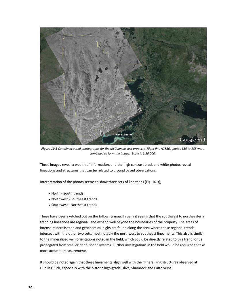
� Figure 10.2 Combined aerial photographs for the McConnells Jest property. Flight line A28301 plates 185 to 188 were
combined to form the image. Scale is 1:30,000.
These images reveal a wealth of informaIon, and the high contrast black and white photos reveal lineaIons and structures that can be related to ground based observaIons.
InterpretaIon of the photos seems to show three sets of lineaIons (Fig. 10.3);
• North -‐ South trends
• Northwest -‐ Southeast trends
• Southwest -‐ Northeast trends
These have been sketched out on the following map. IniIally it seems that the southwest to northeasterly trending lineaIons are regional, and expand well beyond the boundaries of the property. The areas of intense mineralisaIon and geochemical highs are found along the area where these regional trends intersect with the other two sets, most notably the northwest to southeast lineaments. This also is similar to the mineralized vein orientaIons noted in the field, which could be directly related to this trend, or be propagated from smaller riedel shear systems. Further invesIgaIons in the field would be required to take more accurate measurements.
It should be noted again that these lineaments align well with the mineralising structures observed at Dublin Gulch, especially with the historic high-‐grade Olive, Shamrock and Cago veins.
�24

� Figure 10.3 Interpreted structural lineaments on the McConnells Jest property. Three main lineaments are present, N-‐S
(Purple), SE-‐NW (Light Blue), SW-‐NE (Black). Known vein orientaDons are shown in white.
10.3 Rock Types
No geology map was presented for this project, and historically only the Yukon Geological Survey maps had been used which are inaccurate due to their scale.
During the assimilaIon and correlaIon of the data, any informaIon pertaining to rock types was teased from the data, and a database built. At the end of this, over two hundred data points were consolidated and placed in broad lithological categories. Plonng these points, as well as structural data, created an embryonic geological map for further scruIny (Figs. 10.4, 10.5). It has shown that the pluton is more or less the right volume and orientaIon, although it is not homogeneous in texture. There are also several outlying igneous exposures, especially in the northeast, which could represent dyke swarms of a cupola of the main pluton. These also correlate with the Ag-‐Pb mineralisaIon in the area.
There also seems to be a significant inlier of Earn Group sedimentary rocks in the northwestern quadrant, that also aligns with one of the north-‐south lineaments. This could be representaIve of a roof pendant, or faulIng that has created an uneven profile around the pluton.
�25
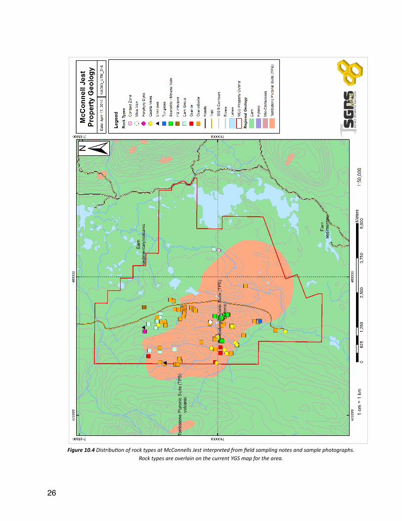
� Figure 10.4 DistribuDon of rock types at McConnells Jest interpreted from field sampling notes and sample photographs.
Rock types are overlain on the current YGS map for the area.
�26
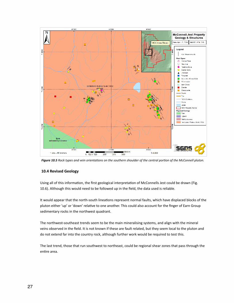
� Figure 10.5 Rock types and vein orientaDons on the southern shoulder of the central porDon of the McConnell pluton.
10.4 Revised Geology
Using all of this informaIon, the first geological interpretaIon of McConnells Jest could be drawn (Fig. 10.6). Although this would need to be followed up in the field, the data used is reliable.
It would appear that the north-‐south lineaIons represent normal faults, which have displaced blocks of the pluton either ‘up’ or ‘down’ relaIve to one another. This could also account for the finger of Earn Group sedimentary rocks in the northwest quadrant.
The northwest-‐southeast trends seem to be the main mineralising systems, and align with the mineral veins observed in the field. It is not known if these are fault related, but they seem local to the pluton and do not extend far into the country rock, although further work would be required to test this.
The last trend, those that run southwest to northeast, could be regional shear zones that pass through the enIre area.
�27

� Figure 10.6 The proposed revised geologic map of McConnells Jest based on structural interpretaDon of the surrounding
geology.
10.5 Interpreta9on
From this gathering and consolidaIon of data, there are several similariIes structurally, geologically and geochemically to Dublin Gulch.
It has to be remembered that the Dublin Gulch discovery was overlooked for someIme due to the lack of a surficial gold anomaly. The lack of a strong gold-‐in-‐soil anomaly at McConnells Jest does therefore not preclude the existence of an ore body.
The proximity to Keno Hill may also mean that we see some silver -‐ lead -‐ zinc mineralisaIon on the property too. These can also be cooler, more distal systems to the pluton, but we cannot rule out some overprinIng from the Keno-‐Elsa corridor.
�28

When a map of McConnells Jest and Dublin Gulch are placed side by side (Fig. 10.7), there is a clear similarity in structural regime, although the McConnells Jest pluton has around double the surface area.
� Figure 10.7 Comparison of structural lineaments at Dublin Gulch (led) and McConnells Jest (right). Both plutons share the same three groups of structural alignments N-‐S (Purple), SE-‐NW (Light Blue) and SW-‐NE (Black). The images are
drawn to the same scale and show that the exposed surface of the McConnell pluton is significantly larger than that at Dublin Gulch.
Such Ag-‐Pb-‐Zn veins also occur at Dublin Gulch, in parIcular their Olive and Shamrock Zones, located about 1km east from the main deposit. It is hypothesized that these veins formed in the crystalline carapace of the pluton, where late stage gases and fluids deposited low-‐temperature minerals into shrinkage fracturing. On the surface, these are expressed as outcroppings of scorodite, a mineral that occurs from the weathering of arsenic-‐rich minerals. Historically, these veins were chased underground in small mining operaIons and were quite producIve, if not short lived.
McConnells Jest has both the sheeted vein systems (Pink Mountain) and scorodite outcrops (Bullion Blister). The presence of Ill cover has somewhat impeded more extensive mapping and collecIon methods, which is something that should be addressed in the future.
11.0 Social Licence 11.1 First Na9ons
The property is located within the tradiIonal territory of the Nacho Nyak Dun First NaIons. The nearest seglement land or R-‐block is R-‐05A on Davidson Range, on the eastern edge of the property and east of McQuesten Lake. Two other nearby R-‐blocks are R-‐09B and A-‐07A, which are located northeast and northwest of the property, respecIvely.
�29
11.2 Environmental Issues
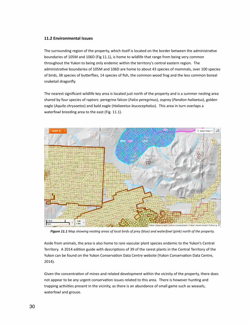
The surrounding region of the property, which itself is located on the border between the administraIve boundaries of 105M and 106D (Fig 11.1), is home to wildlife that range from being very common throughout the Yukon to being only endemic within the territory’s central eastern region. The administraIve boundaries of 105M and 106D are home to about 43 species of mammals, over 100 species of birds, 38 species of bugerflies, 14 species of fish, the common wood frog and the less common boreal snaketail dragonfly.
The nearest significant wildlife key area is located just north of the property and is a summer nesIng area shared by four species of raptors: peregrine falcon (Falco peregrinus), osprey (Pandion haliaetus), golden eagle (Aquila chrysaetos) and bald eagle (Haliaeetus leucocephalus). This area in turn overlaps a waterfowl breeding area to the east (Fig. 11.1).
� Figure 11.1 Map showing nesDng areas of local birds of prey (blue) and waterfowl (pink) north of the property.
Aside from animals, the area is also home to rare vascular plant species endemic to the Yukon’s Central Territory. A 2014 ediIon guide with descripIons of 39 of the rarest plants in the Central Territory of the Yukon can be found on the Yukon ConservaIon Data Centre website (Yukon ConservaIon Data Centre, 2014).
Given the concentraIon of mines and related development within the vicinity of the property, there does not appear to be any urgent conservaIon issues related to this area. There is however hunIng and trapping acIviIes present in the vicinity, as there is an abundance of small game such as weasels, waterfowl and grouse.
�30
11.3 Local Popula9ons
The capital city of Yukon Territory, Whitehorse is located ~350km south of the McConnells Jest property. According to the 2011 NaIonal Household Survey (NHS) the populaIon of Whitehorse is 22,815 where 19,040 have a non-‐Aboriginal idenIty. Amongst the 19,040 people 17,130 have European origins and 1,905 have Asian origins. Filipino (705) and Chinese (535) make up the largest porIons of the Asian visible minority. Other notable visible minoriIes include African (145) and LaIn American (125) (StaIsIcs Canada, 2013).
Local communiIes within ~100km of the McConnells Jest Property include: Elsa (~8km SW), Keno City (~10km SE), Mayo (~45km SW) and Stewarts Crossing (~90km SW).
According to the 2011 NaIonal Census, amongst the local communiIes, Mayo is largest with a populaIon of 226, followed by Keno Hill (Keno City) with a populaIon of 28 and Stewarts Crossing with a populaIon of 25 (StaIsIcs Canada, 2012c).
Elsa is considered a ghost town as its populaIon moved out following the closure of the United Keno Hill mine in 1989.
According to StaIsIcs Canada, 2011 NHS data for Mayo, Keno City and Stewarts Crossing has been suppressed for data quality or confidenIality reasons (StaIsIcs Canada 2012a,b and d). Due to this, ethniciIes for these communiIes is not public data.
12.0 Recommenda9ons
EssenIally this project is at a crucial point. The work so far has proven several similariIes to Dublin Gulch, but the economic downturn has detracted potenIal investors from a property that shows sporadic anomalous assays. Two main factors have to be remembered here:
■ The property is surrounded by mines that have successfully operated for many years, with new sites coming online in the next decade. These are not distal properIes, but border the property and have geological conInuity.
■ The Eagle Zone at Dublin Gulch contains a global resource of 6.3 MOz of gold, yet has ligle to no geochemical expression on surface.
The next steps at McConnells Jest would follow these points:
�31

■ Basic Mapping: The property needs to have a geological map produced, showing the rock types, alteraIon, structures and mineralisaIon. Although this is somewhat difficult due to the glacial Ill cover, there is enough exposure on the high points to get a large porIon of the property mapped.
■ Scorodite Prospec9ng: If the property follows the Intrusion Related Gold model, then gold was delivered in late stage quartz or arsenopyrite veins which will be spaced 20-‐50m apart. As Scorodite is easy to idenIfy on surface, prospecIng this will reveal not only the grades, but also structural alignments. These can then be traced out over the enIre property to idenIfy other areas of interest.
■ Sheeted Vein Prospec9ng: Typically, a series of aligned quartz veins host a significant porIon of the gold in these systems. Mapping of the area, parIcularly in the northern and southern shoulders to locate areas of the highest density of veining. Once these are idenIfied, these would produce the first exploraIon targets for future drill programs.
■ Iden9fy Calcareous Areas of the Earn Group: Looking for these horizons in the country rock could show evidence of skarn mineralisaIon. On the south-‐eastern side of the Dublin Gulch intrusion, contact with such layers produced a large tungsten deposit. A NaIonal Instrument 43-‐101 report authored by SRK ConsulIng (2008) stated that the Mar-‐Tungsten deposit contains 65.7 million pounds of tungsten in the Indicated category, and an addiIonal 8.5 million pounds Inferred. This has not been studied at McConnells Jest, and doing so would complete the picture according the regional mineralisaIon models.
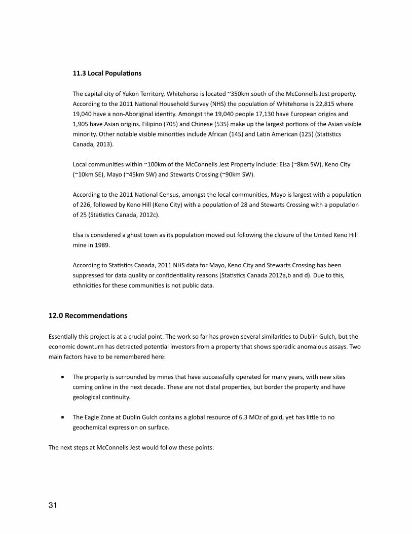
■ The following map (Fig. 12.1) shows several target areas that are favourable for a variety of reasons. The most compelling are those that are in intersecIonal areas of the lineaments.
Much of this work would be undertaken by geologists in the field, collecIng more informaIon and samples from specific outcrops. Knowledge of the Dublin Gulch system will be an asset when looking at this ground.
Methods for sampling Ill have come a long way in recent years, especially on the geochemical front, with several laboratories offering specialized services. It could be proposed that addiIonal soil work be undertaken in the southern and eastern porIons, but only when regional trends had been idenIfied from mapping, thus giving confidence in these potenIal extensions.
Access to the bedrock could also be achieved either by trenching or drilling. In both instances, it would be recommended to look at mobile, heliportable apparatus as the property is not directly accessible by ground at this stage. Low impact excavaIons also fit within exisIng exploraIon permits and demonstrate environmental stewardship.
�32
� Figure 12.1 ExploraDon targets generated from the geologic interpretaDons of the McConnells Jest property above. A total of 6
targets are proposed based on geochemical and structural data.
In addiIon to geological work, it would be prudent at this stage to include some level of environmental assessment projects. Before any ground disturbance occurs through drilling or trenching, it is recommended to take water samples from the streams to analyze for basic composiIon and dissolved mineral content. This should be prioriIzed in the areas directly downstream from the scorodite veins that will likely be loading the water with arsenic, lead and anImony. Having these results acts almost as an ‘insurance’ policy to prove that any elevated levels measured in the future are not a direct consequence of exploratory work. Water sampling should be planned out in advance, as the samples need to reach a lab within 24 hours of being collected.
�33

Other general environmental studies should be considered also: vegetaIon mapping, stream delineaIon (permanent waterways versus ephemeral streams as these will define protecIve buffers for exploraIon acIvity), and also some basic wildlife / plant surveys.
All of this work could be accomplished in a single field season with an experienced team of geologists / geotechnicians. Depending on funding available, the team could either fly camp on the site, or fly in from accommodaIons in Keno, Mayo or even the camp at Dublin Gulch.
The product of this work program would be to define structures and confirm the geological model. This would generate drill targets for future years and generate further investment interest.
�34
13.0 References
Abbog, J.G., Gordey, S.P., and Templeman-‐Kluit, D.J., 1986, Senng of straIform, sediment hosted lead-‐zinc deposits in Yukon and northeastern BriIsh Columbia, In: Morin, J.A., (Ed.), Mineral deposits of the northern Cordillera: Canadian InsItute of Mining and Metallurgy Special Volume 37, p. 1–18.
Alexco Resources Corp., 2012, Preliminary ReclamaIon and Closure Plan, Keno District Mine OperaIons, Keno Hill Silver District, Revision 2 (internal report for Alexco Resources Corp. September 30, 2012), 306 p.
Bond, J.D, 1999, Glacial Limits and Ice Flow Pagerns, Mayo Area, Central Yukon, Geoscience Map 1999-‐13: ExploraIon and Geological Services Division, Yukon Region, Indian and Northern Affairs Canada, 1:250,000 scale.
Cathro, R.J., 2006, The history and geology of the Keno Hill Silver Camp, Yukon Territory: Geoscience Canada, v. 33, p. 103–134.
Golden Predator Canada Corp., 2011, Assessment Report, 2010 Sampling Program, McConnell Property, Mayo Mining Division, Yukon Canada, internal report prepared for Bill Koe-‐Carson dated May 3rd 2011.
Golden Predator Canada Corp., 2013, Assessment Report, 2012 Sampling Program, McConnell Property, Mayo Mining Division, Yukon, Canada, internal report prepared for Bill Koe-‐Carson dated April 4th 2013.
Gordey, S.P., and Makepeace, A.J., 2003, Yukon Digital Geology, version 2.0, S.P., Gordey, and A.J., Makepeace (comp); Geological Survey of Canada, Open File 1749 and Yukon Geological Survey, Open File 2003-‐9 (D)
Gordey, S.P., and Anderson, R.G., 1993, EvoluIon of the northern Cordilleran miogeocline, Nahanni map area (105I), Yukon and Northwest Territories: Geological Survey of Canada, Memoir 248, p. 214.
Green, L.H., 1972, Geology of the Nash Creek, Larsen Creek and Dawson Map areas, Yukon Territory: Geological Survey of Canada, Memoir 364, 157 p.
Hammer, Ø, Harper, D.A.T., and Ryan, P.D., 2001, Past: Paleontological StaIsIcs Sowware Package for EducaIon and Data Analysis. Palaeontologia Electronica, vol. 4, issue 1, p. 4-‐9, 178kb. hgp://palaeo-‐electronica.org/2001_1/past/issue1_01.htm.
Hantelmann, J.J., 2013, The paragenesis and geochemistry of the Bellekeno Ag-‐Pb-‐Zn vein, Keno Hill district, Yukon, Canada: Unpublished M.Sc. thesis, University of Alberta, Edmonton, Canada, 292 p.
Hart, C.J.R, 2004, Mid-‐Cretaceous magmaIc evoluIon and intrusion-‐related metallogeny of the TinIna Gold Province, Yukon and Alaska: Unpublished PhD. thesis, University of Western Australia, Perth, 188p.
Hart, C.J.R., 2005, Classifying, disInguishing and exploring for intrusion-‐related gold systems: The Gangue: Newsleger of the Geological AssociaIon of Canada Mineral Deposits Division, v. 87, p. 1, 4–9.
Hart, C.J.R., 2007, Reduced intrusion-‐related gold systems, In: Goodfellow, W.D. (Ed.), Mineral deposits of Canada: A synthesis of major deposit types, district metallogeny, the evoluIon of geological provinces, and exploraIon methods: Geological AssociaIon of Canada, Mineral Deposits Division, Special PublicaIon No. 5, p. 95-‐112.
�35
Hart, C.J.R., Mair, J.L., Goldfarb, R.J., and Groves, D.I., 2004, Source and redox controls on metallogenic variaIons in intrusion-‐related ore systems, Tombstone-‐Tungsten belt, Yukon Territory, Canada: TransacIons of the Royal Society of Edinburgh, Earth Science, v. 95, p. 319−337.
Hitchins, A.C., and Orssich, C.N., 1995, The Eagle zone gold-‐tungsten sheeted vein porphyry deposit and related mineralizaIon, Dublin Gulch, Yukon Territory: Canadian InsItute of Mining and Metallurgy, Special Volume 46, p. 803–810.
Koe-‐Carson, B., 2010, McConnells Jest, 2010 Field Journal Notes, Final Report, Yukon Mining IncenIves Program #10-‐001, 9 p.
Lang, J.R. and Baker, T., 2001, Intrusion-‐related gold systems: the present level of understanding: Mineralium Deposita, v. 36, p. 477-‐489.
Mair, J.L., Hart, C.J.R., and Stephens, J.R., 2006, DeformaIon history of the western Selwyn Basin, Canada: ImplicaIons for orogen evoluIon and the senng of mid-‐Cretaceous magmaIsm: Geological Society of America BulleIn, v. 118, p. 304−323.
Mair, J.L., Farmer, G.L., Groves, D.I., Hart, C.J.R and Goldfarb, R.J., 2011, Petrogenesis of Postcollisional MagmaIsm at Scheelite Dome, Yukon, Canada: Evidence for a Lithospheric Mantle Source for Magmas Associated with Intrusion-‐Related Gold Systems, Economic Geology, v. 106, p. 451–480.
MinFile#: 106D 055, 2008, Yukon MinFile for the "Zed" occurrence, Yukon Geological Survey.
Murphy, D.C., 1997, Geology of the McQuesten River region, northern McQuesten and Mayo Map Area, Yukon Territory (115P/14, 15, 16; 105M/13, 14): ExploraIon and Geological Services Division, Yukon, Indian and Northern Affairs Canada BulleIn 6.
Pearson, K., 1896, MathemaIcal contribuIons to the theory of evoluIon. III. Regression, heredity, and panmixia: Philosophical TransacIons of the Royal Society A, v. 187, p. 253–318.
Rasmussen, K.L., 2013, The Iming, composiIon, and petrogenesis of syn-‐ to postaccreIonary magmaIsm in the northern Cordilleran miogeocline, eastern Yukon and southwestern Northwest Territories: Unpublished Ph.D. Thesis, University of BriIsh Columbia, Vancouver, Canada, 810 p.
Roots, C.F., 1997, Geology of the Mayo Map area, Yukon Territory (105M): ExploraIon and Geological Services Division, Yukon, Indian and Northern Affairs Canada, BulleIn 7, 82 p.
Scog Wilson Mining, 2010, Technical Report on the Dublin Gulch Property, Yukon Territory, Canada: NI 43-‐101 technical report (internal report for Victoria Gold Corp., April 23, 2010), 242 p.
Selby, D., Creaser, R.A., Heaman, L.M., and Hart, C.J.R., 2003, Re–Os and U–Pb geochronology of the Clear Creek, Dublin Gulch, and Mactung deposits, Tombstone Gold Belt, Yukon, Canada: absolute Iming relaIonships between plutonism and mineralizaIon, Canadian Journal of Earth Science, v. 40, p. 1839–1852.
Spearman, C.E., 1904, The proof and measurement of associaIon between two things: American Journal of Psychology, v. 15, p. 72-‐101.
�36
SRK ConsulIng, 2008, Dublin Gulch Property – Mar-‐Tungsten zone Mayo District, Yukon Territory, Canada: NI 43-‐101 technical report, (internal report for StrataGold Corp., Dec. 1 2008), 161 p.
SRK ConsulIng, 2014, Updated Preliminary Economic Assessment for the Keno Hill Silver District Project – Phase 2, Yukon, Canada: NI 43-‐101 technical report (internal report for Alexco Resources Corp., December 10, 2014), 381 p.
StaIsIcs Canada, 2012a, Keno Hill, Yukon (Code 6001052) and Yukon (Code 60) (table), Census Profile, 2011 Census: StaIsIcs Canada Catalogue no. 98-‐316-‐XWE, Ogawa, Released October 24, 2012.
StaIsIcs Canada, 2012b, Mayo, Yukon (Code 6001022) and Yukon (Code 60) (table), Census Profile, 2011 Census: StaIsIcs Canada Catalogue no. 98-‐316-‐XWE, Ogawa, Released October 24, 2012.
StaIsIcs Canada, 2012c, PopulaIon and dwelling counts, for Canada, provinces and territories, and census subdivisions (municipaliIes), 2011 and 2006 censuses (table), PopulaIon and Dwelling Count Highlight Tables. 2011 Census: StaIsIcs Canada Catalogue no. 98-‐310-‐XWE2011002, released February 8, 2012.
StaIsIcs Canada, 2012d, Stewart Crossing, Yukon (Code 6001050) and Yukon (Code 60) (table), Census Profile, 2011 Census: StaIsIcs Canada Catalogue no. 98-‐316-‐XWE, Ogawa, Released October 24, 2012.
StaIsIcs Canada, 2013, Whitehorse, CY, Yukon (Code 6001009) (table), NaIonal Household Survey (NHS) Profile, 2011 NaIonal Household Survey: StaIsIcs Canada Catalogue no. 99-‐004-‐XWE, Ogawa, Released September 11, 2013.
Wardrop Engineering Inc., 2011, Technical report on the Eagle zone, Dublin Gulch property, Yukon Territory, Canada: NI 43-‐101 technical report, (internal report for Victoria Gold Corp., April 15 2011), 48 p.
Wardrop Engineering Inc., 2012, Technical report on the Eagle zone, Dublin Gulch property, Yukon Territory, Canada: NI 43-‐101 technical report, (internal report for Victoria Gold Corp., April 05 2012), 419 p.
Yukon ConservaIon Data Centre, 2014, Rare species database: Yukon Department of Environment, Whitehorse, Yukon, www.env.gov.yk.ca/cdc, accessed April 8, 2015.
�37

Appendix 1: Team Details and Qualifica9ons
Andrew Randell (PGeo)
Andy is a Professional GeoscienIst (PGeo) registered with the AssociaIon of Professional Engineers and GeoscienIsts in BriIsh Columbia (APEGBC).
He has over a decade of experience across a mulItude of mineral exploraIon and mining project types and commodiIes, specializing in geological mapping, design of exploraIon projects and drilling programs, geochemical targets, soil sampling, mineralogy and metallurgy.
Fraser Kirk
Fraser Kirk is a geologist and research scienIst. He holds a B.Sc. (Hons) in Geoscience from the University of St Andrews, Scotland and is currently compleIng a M.Sc. in Geochemistry and Economic Geology at Memorial University, NL, Canada. His research focuses on gold mineralisaIon at the Dublin Gulch property, YT, Canada; using mineralogical studies, geochemistry, stable and radiogenic isotopes, and U-‐Pb daIng to determine the genesis and distribuIon of gold there. Fraser seeks to integrate a tradiIonal ‘boots on the ground’ approach with modern geochemical techniques to accurately and efficiently solve geologic problems. In addiIon, Fraser has a keen interest
in quality systems, parIcularly the TQM model and its applicaIon to mineral exploraIon.
Hanson Wong
Hanson is an avid volunteer at the University of BriIsh Columbia’s Pacific Museum of the Earth, where he regularly conducts earth science related workshops and museum tours for school groups visiIng the Museum. He holds a B.Sc. in Earth Sciences from Simon Fraser University and has a keen interest in paleontology. He has experience doing fieldwork in northeastern BriIsh Columbia for a Junior coal exploraIon company and a paleontological consultant company.
�38

Carrie Wong
Carrie Wong is a GIT with three years good standing at APEGBC. She graduated with honors from the University of BriIsh Columbia in 2011. She has worked in the gold exploraIon industry and spent a few summer seasons in the Yukon. She has created hundreds of maps over the years. From acQuire database management to logging core with world experts (like Dr. Richard Sillitoe within a porphyry system), Carrie has had a number of diverse roles within the mining industry. In response to the mining recession, she has launched her own cartography business and is looking for clients. She has also wrigen arIcles for www.geologyforinvestors.com. For more informaIon:
www.wongmanagement.ca
Daniela Marcoux
Daniela holds an Honours BSc in Geology from the University of Ogawa. A registered G.I.T. and a true lover of her homeland, her experience is mainly based in the foundaIon of it all, the Canadian shield. Amongst her experience she has worked on the Borden Gold Project, recently acquired by Goldcorp. Her geological interests include: any project that can sImulate the country's economy, mineral deposits in greenstone provinces and cold beer.
�39