modified block t5/6 project city center eir ceqa analysis
TRANSCRIPT

City Project No. ER‐15003 i May 29, 2015 ESA Project No. 140343
TABLE OF CONTENTS 1100 Clay Street – Modified Block T5/6 Project City Center EIR CEQA Analysis
Page
I. Executive Summary 1
II. Background 2
III. Purpose and Summary of this Document 10
IV. Project Description 14
V. Summary of Findings 32
VI. CEQA Checklist 33 1. Aesthetics 34 2. Air Quality 39 3. Biological Resources 47 4. Cultural Resources 49 5. Geology, Soils, and Geohazards 52 6. Greenhouse Gas and Climate Change 55 7. Hazards and Hazardous Materials 60 8. Hydrology and Water Quality 63 9. Land Use, Plans, and Policies 66 10. Noise 68 11. Population and Housing 73 12. Public Services, Parks and Recreation 75 13. Transportation and Circulation 77 14. Utilities and Service Systems 96
VII. References 139
List of Figures
1. Project Location and Context 3 2. Approved Project Site Plan 4 3. Existing Block T5/6 15 4a. Existing Block T5/6 Photos/Aerials 16 4b. Existing Block T5/6 Photos/Aerials 17 5. Modified Block T5/6 Plan – Site A (Phase 1) 20 6. Modified Block T5/6 Illustration – Site A (Phase 1) Final PUD 22

1100 Clay Street CEQA AnalysisModified Block T5/6 Project
City Project No. ER‐15003 ii May 29, 2015 ESA Project No. 140343
List of Figures (continued)
7. Modified Block T5/6 Plan – Site B (Phase 2) Option 1: Hotel 23 8. Modified Block T5/6 Plan – Site B (Phase 2) Option 1: Residential 24 9. Modified Block T5/6 Plan – Site B (Phase 2) Option 1: Office 25 10. Modified Block T5/6 Plaza Plan – Site A (Phase 1) 27
List of Tables
1. Development Characteristics of Original Project, 2000 EIR 5 2. Development Characteristics of Approved Modified Project, through Addendum #4, 2010 6 3. Proposed Modified T5/6 Development Program Compared to Original Project 19 AIR‐1 Unmitigated Emissions From Construction (average lbs per day) 41 AIR‐2 Unmitigated Emissions From Operation (lbs per day) 42 AIR‐3 Cumulative Health Impacts for New Receptors 45 GHG‐1 GHG Emissions From Operation (metric tons per year) 56 NOI‐1 Peak‐Hour Traffic Noise Levels in the Vicinity of the Project 70 TRA‐1 Intersection LOS Summary ‐ Existing Conditions 80 TRA‐2 Oakland City Center Development (T5/6) – Automobile Trip Generation Summary –
Option 1 (Residential/Hotel) 81 TRA‐3 Oakland City Center Development (T5/6) – Automobile Trip Generation Summary –
Option 2 (Residential/Residential) 81 TRA‐4 Oakland City Center Development (T5/6) – Automobile Trip Generation Summary –
Option 3 (Residential/Office) 82 TRA‐5 Trip Generation By Travel Mode – Option 3 83 TRA‐6 Intersection LOS Summary ‐ Existing Plus Project 85 TRA‐7 Intersection LOS Summary ‐ 2035 Conditions 86 TRA‐8 Project Parking Supply and Demand 93 TRA‐9 Automobile Parking Code Requirements 93 TRA‐10 Bicycle Parking Requirements 94 D‐1 Project Infill Eligibility (in Attachment D) 134
Attachments
A. Standard Conditions of Approval and Mitigation Monitoring and Reporting Program 99 B. Criteria for Use of Addendum, Per CEQA Guidelines Sections 15162, 15164, and 15168 129 C. Project Consistency with Community Plan or Zoning, Per CEQA Guidelines
Section 15183 133 D. Infill Performance Standards, Per CEQA Guidelines Section 15183.3 134
Appendices
A. Reference Figures from 2000 EIR Aesthetics Analysis B. Transportation LOS Sheets and Background

1100 Clay Street CEQA Analysis Modified Block T5/6 Project
City Project No. ER‐15003 1 May 29, 2015 ESA Project No. 140343
Oakland City Center Project Modified Block T5/6 Project
CEQA Analysis
Pursuant to California Resources Code Sections 21083.3, 21094.5.5, and 21166 and CEQA Guidelines Sections 15162, 15164, 15183, 15183.3, 15168, and 15180
Date: May 29, 2015
Project Address: 1100 Clay Street, Block T5/6
Case Number: PUD99‐ER15003
Zoning: CBD‐C (Central Business District General Commercial
Zone)
General Plan: Central Business District (CBD)
APNs: Site A: 02‐97‐38 Site B: 02‐97‐39 and 02‐97‐40
Lot Size: 1.25 acres
Applicant: Strada T5, LLC
Strada Investment Group
101 Mission Street, Suite 420
San Francisco, CA 94105
Staff Contact: Catherine Payne, Planner III
Bureau of Planning [email protected]
(510) 238‐6168
I. Executive Summary The proposed Modified Block T5/6 Project (“proposed project” or “Modified T5/6 Project”) would be
developed on an approximately 1.25‐acre parcel that is one of four development blocks that make up the
Oakland City Center Project in Downtown Oakland.
The City certified an Environmental Impact Report (EIR) for the Oakland City Center Project Preliminary
Planned Unit Development (PUD) in April 2000, pursuant to the California Environmental Quality Act
(CEQA).1 The “Original Project” analyzed in the 2000 EIR considered the development of a 580,000
square‐foot commercial office building up to 390 feet tall with ground floor retail space on Block T5/6. A
total of up to 200 parking spaces would be provided on‐site or in an existing adjacent City parking garage.
The Modified T5/6 Project now proposes three possible development options on Block T5/6, which would
be developed in two phases on two sites: Phase 1 on Site A and Phase 2 on Site B. The project sponsor also
seeks approval of amended revised Preliminary PUD for the entire Block T5/6, and a Final PUD for Site A
(Phase 1), which would be developed as an up‐to‐262 unit residential building with up to 6,800 square feet
of ground‐floor retail space. Site B (Phase 2) will be subject to a Final PUD application at a later date, once
1 Oakland City Center Project Final EIR, Certified April 26, 2000. SCH No. 99081119. Oakland Case No. ER99‐15.

1100 Clay Street CEQA Analysis Modified Block T5/6 Project
City Project No. ER‐15003 2 May 29, 2015 ESA Project No. 140343
the project sponsor has determined the final use option for Site B: Option 1, a 300‐room hotel; Option 2, a
second 262‐unit residential building; or Option 3: a 205,800 square‐foot office building. All three options
would include up to 8,000 square feet of ground‐floor retail space.
All buildings developed in the Modified T5/6 Project would be a maximum of 150 feet tall. All parking
would be provided on‐site in addition to the continued option of using up to 200 parking spaces available in
the adjacent City Center Parking Garage through an existing license agreement with the City of Oakland.
The Modified T5/6 Project will involve a maximum total of approximately 66,000 cubic yards of excavation
to accommodate up to three levels of underground parking under each of the buildings. Construction of
Phase 1 is of the project is to commence prior to 2018, with construction of Phase 2 projected to start by
2020.
Overall, the Modified T5/6 Project would develop up to approximately 137,600 fewer square feet of
development, and result in approximately 50 percent fewer p.m. peak‐hour vehicle trips, compared to that
analyzed in the EIR, and would introduce residential and the option for hotel use on the site.
The 2000 EIR, and four subsequent addenda to that EIR, analyzed the environmental impacts of adoption
and implementation of the City Center Project. The analysis in the 2000 City Center EIR and its four
addenda directly apply to the Modified T5/6 Project, providing the basis for use of an Addendum.
Separate and independently, qualified planning level documents, specifically program‐level EIRs, that can
be used as a basis to provide additional CEQA clearance of the Modified T5/6 Project (all or in part) under
specific CEQA provisions include Oakland’s 1998General Plan Land Use and Transportation Element EIR,
the 2010 General Plan Housing Element Update EIR and 2014 Addendum, and the 2011 Central District
Urban Renewal Plan Amendments EIR (or “Redevelopment Plan Amendments EIR”). These are referred to
collectively throughout this document as “the Program EIRs” or “the Previous CEQA Documents.”
II. Background
Original 2000 EIR Project In April 2000, the Oakland Planning Commission certified the EIR and approved a Preliminary PUD for
the Oakland City Center Project. The Original Project analyzed in the 2000 EIR consisted of a Preliminary
PUD program of approximately 2.2 million square feet (msf) of high‐rise building development on the
four city blocks: Blocks T5/6, T9, T10 and T12. The Original Project location and development blocks are
shown in Figure 1 and Figure 2, respectively. Table 1 shows the development program of the Original
Project.
The 2000 EIR (including its Initial Study Checklist) determined that the Oakland City Center Project’s
impacts to the following resources would be reduced to a less‐than‐significant level with the
implementation of mitigation measures: circulation and parking, air quality, and noise (in the EIR);
geology and soils, hydrology and water quality, cultural resources, and hazards and hazardous materials
(in the Initial Study). Less‐than‐significant impacts were identified for the following resources:
aesthetics; biology; land use, plans, and policies; population and housing; public services, recreation, and
utilities and service systems.
The 2000 EIR determined that the Oakland City Center Project would have significant unavoidable
effects on the following environmental resources: traffic delays; air quality (cumulative); noise
(cumulative); and wind hazards. Due to the potential for significant unavoidable impacts, a Statement of
Overriding Considerations was adopted as part of the City’s approvals.

Figure 1Project Location and Context
SOURCE: Oakland City Center Project DEIR (2000)
0 750
Feet
Oakland Convention Center
Lafayette Square Park
City Center West Garage
10th Street
11th Street
12th Street
Trans-Pacific Center
Mar
tin L
uthe
r Kin
g Jr
. Way
Jeffe
rson
Stre
et
Cla
y St
reet
Broa
dway
Web
ster
Stre
et
Fran
klin
Stre
et
14th Street
BLOCK T5/6
City Center T5/6 Addendum . ESA 140343
San
Fran
cisc
o-O
akla
nd
B
ay B
ridg
e
A L A M E D A
O A K L A N D E M E R Y V I L L E
S A N L E A N D R O
P I E D M O N T
580
880
980
80
BART
580
PROJECT SITE
Project Site

Figure 2Approved Project Site Plan
SOURCE: Oakland City Center Project DEIR (2000)
0 320
Feet
City Center T5/6 Addendum . ESA 140343
12th Street
Cas
tro S
treet
Jeffe
rson
Stre
et
Cla
y St
reet
Fran
klin
Stre
et
Broa
dway
Mar
tin L
uthe
r Kin
g Jr
. Way
14th Street
11th Street
10th Street
Oakland Convention Center
Marriott
Federal Building
Project Site
Block T5/T6
C i t y C e n t e r
Lafayette Square Park
Preservation Park
City Center West Garage
Frank H. Ogawa Plaza
City Hall
Clay St. Garage

1100 Clay Street CEQA Analysis Modified Block T5/6 Project
City Project No. ER‐15003 5 May 29, 2015 ESA Project No. 140343
TABLE 1 DEVELOPMENT CHARACTERISTICS OF ORIGINAL PROJECT, 2000 EIR
Block T5/6 Block T9 Block T10 Block T12
Original Project (2000 EIR)
Office 580,000 sf 470,000 sf 550,000 sf 584,000 sf 2,184,000 sf
Residential 0 0 200 units 0 200 units
Commercial 7,500 sf 7,500 sf 8,000 sf 0 23,000 sf
Parking 150 spaces 236 spaces 230 spaces 220 spaces 836 spaces
Parking access 11th Street 11th Street Jefferson St. 11th Street N/A
Loading Spaces 3 3 3 3 12 spaces
Loading access 11th Street 11th Street MLK Jr. Way 11th Street N/A
Hgt. (stories) 26 stories 21 stories 31 stories 26 stories Max. 31 stories
Height (feet) a 390 feet 306 feet 440 feet 390 feet Max. 440 feet
a In the 2000 EIR, all Blocks were modeled at 440 feet tall shadow and scenic resources, and at 425 feet for the wind
analyses in the 2000 EIR.
Previous Addenda and “Approved Project”
Four addenda to the 2000 EIR were completed to consider modifications to the Original Project:
Addendum #1 for Block T10 (2003); and Addenda #2 through #4 for Block T12 (2005, 2007 and 2010). The
development programs for each addendum are summarized in Table 2. As described below, each of the
addenda determined that no further review was required, in terms of a subsequent or supplemental EIR,
pursuant to CEQA Guidelines Sections 15162 and 15164 (Subsequent EIRs, Supplements and Addenda to
an EIR or Negative Declaration). Development on Blocks T9 and T10 are fully constructed and
operational. Throughout this document, except where necessary for clarity, “2000 EIR” encompasses the
Initial Study, Draft EIR, Final EIR, and each subsequent addendum for the City Center Project.
The 2003 Addendum #1 found that a Modified Block T10 project, which increased the residential units
and decreased office square footage on Block T10, would have no new or substantially severe impacts
compared to what was identified in the 2000 Final EIR.
The 2005 Addendum #2, which considered an increased number of residential units for Block T12,
confirmed that increased traffic anticipated from other new development that had occurred near Block
T12 would not cause the Modified Block T12 project to adversely affect intersections, specifically once the
Uptown Project was completed.2 The analysis concluded that there would be little interaction between
traffic from Modified Block T12 project and the Uptown project at the affected intersections.3
2 The Uptown project is an approximately 1,270‐unit residential complex on nine blocks, generally between San Pablo and
Telegraph Avenues, from 19th to 21st Streets. The other new nearby development considered included Landmark Place, a 92‐unit
condominium complex at Martin Luther King Jr. Way and 12th Street (directly west of Block T12); and the Market Square Phase
1 project, a 115‐unit residential project at 9th Street, between Clay and Jefferson Streets (two blocks south of Block T12, former
Housewives’ Market). 3 Since certification of Addendum #2, all projects being developed in the Downtown area have included the City Center Project in
their cumulative traffic analyses.

1100 Clay Street CEQA Analysis Modified Block T5/6 Project
City Project No. ER‐15003 6 May 29, 2015 ESA Project No. 140343
TABLE 2 DEVELOPMENT CHARACTERISTICS OF APPROVED MODIFIED PROJECT,
THROUGH ADDENDUM #4, 2010
Block T5/6 Block T9 Block T10 Block T12
Approved Modified Project,
through Addendum #4
(2010)
Original Project
(2000 EIR)
(approved, Original Project)
(as constructed, approved in
Original Project)
(as constructed, reduced from
Original Project
a)
(approved, Addendum
#4 b
)
Office 580,000 sf 470,000 sf 0 584,000 sf 1,634,000 sf 2,184,000 sf
Residential 0 0 251 units 0 251 units 200 units
Commercial 7,500 sf 7,500 sf 2,600sf 0 17,600 sf 23,000 sf
Parking 150 spaces 236 spaces 252 spaces 220 spaces 858 spaces 836 spaces
Parking access 11th Street 11th Street Jefferson St. 11th Street N/A N/A
Loading Spaces 3 3 1 3 12 spaces 12 spaces
Loading access 11th Street 11th Street 14th Street 11th Street N/A N/A
Hgt. (max stories) 26 stories 21 stories 8 stories 26 stories Max. 26 stories Max. 31 stories
Height (feet) 390 feet 306 feet 80 feet 390 feet Max. 390 feet Max. 440 feet
a Block T10 was evaluated in and approved with Addendum #1 with 400 units, 3,000 to 10,000 square feet of commercial, 400
parking spaces, and a maximum height of 240 feet. b Block T12 was also previously modified from the Original Project in Addendum #2 and Addendum #3.
c In the 2000 EIR, all Blocks were modeled at 440 feet tall shadow and scenic resources, and at 425 feet for the wind analyses
in the 2000 EIR.
The 2007 Addendum #3 and 2010 Addendum #4 were completed to address the reversion of the Modified
Block T12 project of Addendum #2 to office use. Both addenda found that the four significant and
unavoidable impacts of the City Center Project in the 2000 EIR, which are primarily due to the office
component of the City Center Project, would remain the same and that no new or severe impacts were
found. The CEQA Analysis for the Modified T5/6 Project assumes development of Block T12 with a high‐
rise office building, as approved in the Original Project and analyzed in the 2000 EIR and the most recent
Addendum #4.
Applicable Previous CEQA Documents / Program EIRs
The analysis in the 2000 City Center EIR and its four addenda directly apply to the Modified T5/6 Project,
providing the basis for use of an Addendum. The following describes the Program EIRs that constitute
the Previous CEQA Documents considered in this CEQA Analysis. Each of the following documents are
hereby incorporated by reference and can be obtained from the City of Oakland Bureau of Planning at
250 Frank H. Ogawa Plaza, Suite 2114, Oakland, California 94612, and/or located at http://ec2‐54‐235‐79‐
104.compute‐1.amazonaws.com/Government/o/PBN/OurServices/Application/DOWD009157.htm.
Land Use and Transportation Element EIR The City certified the EIR for its General Plan Land Use and Transportation Element (LUTE) in 1998. The
LUTE identifies policies for utilizing Oakland’s land as change takes place and sets forth an action
program to implement the land use policy through development controls and other strategies. The LUTE
identifies five “Showcase Districts” targeted for continued growth; the City Center Project and Block T5/6

1100 Clay Street CEQA Analysis Modified Block T5/6 Project
City Project No. ER‐15003 7 May 29, 2015 ESA Project No. 140343
are located within the “Downtown Showcase District” (Downtown) intended to promote a mixture of
vibrant and unique districts with around‐the‐clock activity, continued expansion of job opportunities,
and growing residential population. The 1998 LUTE EIR is designated a “Program EIR” under CEQA
Guidelines Sections 15183 and 15183.3. As such, subsequent activities under the LUTE are subject to
requirements under each of the aforementioned CEQA Sections, which are described further in Section
III. While approved after certification of the 1998 LUTE EIR, growth and potential effects of the
development of City Center in downtown Oakland would have been considered in the cumulative
growth projections factored into the LUTE EIR analysis.
Applicable mitigation measures identified in the 1998 LUTE EIR are largely the same as those identified
in the other Program EIRs prepared after the 1998 LUTE EIR, either as mitigation measures or newer
standard conditions of approval, the latter of which are described below in Section III.
Environmental Effects Summary – 1998 LUTE EIR
The 1998 LUTE EIR (including its Initial Study Checklist) determined that development consistent with
the LUTE would result in the following impacts reduced to a less‐than‐significant level with the
implementation of mitigation measures and/or standard conditions of approval (described in Section
III): aesthetics (views, architectural compatibility and shadow only); air quality (construction dust
[including PM10] and emissions Downtown, odors); cultural resources (except as noted below as less
than significant); hazards and hazardous materials; land use (use and density incompatibilities); noise
(use and density incompatibilities, including from transit/transportation improvements); population and
housing (induced growth, policy consistency/clean air plan); public services (except as noted below as
significant)4; and transportation/circulation (intersection operations Downtown).
Less‐than‐significant impacts were identified for the following resources in the 1998 LUTE EIR and
Initial Study: aesthetics (scenic resources, light and glare); air quality (clean air plan consistency,
roadway emissions in Downtown, energy use emissions, local/regional climate change); biological
resources; cultural resources (historic context/settings, architectural compatibility); energy; geology and
seismicity; hydrology and water quality; land use (conflicts in mixed use projects and near transit); noise
(roadway noise Downtown and citywide, multifamily near transportation/transit improvements);
population and housing (exceeding household projections, housing displacement from industrial
encroachment); public services (water demand, wastewater flows, stormwater quality, parks services);
and transportation/circulation (transit demand). No impacts were identified for agricultural or forestry
resources, and mineral resources.
Significant unavoidable impacts were identified for the following environmental resources in the 1998
LUTE EIR: air quality (regional emissions, roadway emissions Downtown); noise (construction noise and
vibration in Downtown); public services (fire safety); transportation/circulation (roadway segment
operations); wind hazards, and policy consistency (clean air plan). Due to the potential for significant
unavoidable impacts, a Statement of Overriding Considerations was adopted as part of the City’s
approvals.
Oakland Housing Element Update EIR and Addendum
Since the 2000 EIR, the City has twice amended its General Plan to adopt updates to its Housing Element.
It certified a 2010 EIR for the 2007‐2014 Housing Element, and a 2014 Addendum to the 2010 EIR for the
4 The 1998 LUTE EIR addressed effects on solid waste demand and infrastructure facilities for water, sanitary sewer and
stormwater drainage under Public Services.

1100 Clay Street CEQA Analysis Modified Block T5/6 Project
City Project No. ER‐15003 8 May 29, 2015 ESA Project No. 140343
2015‐2023 Housing Element. The General Plan identifies the City’s current and projected housing needs,
and sets goals, policies, and programs to address those needs, as specified by the state’s Regional Housing
Needs Allocation (RHEA) process. Although City Center Block T5/6 is not specified as a “Housing
Opportunity Site” in the 2015‐2023 Housing Element, the propose project would contribute to the total
number of housing units needed in the City of Oakland to meet its RHNA target. Applicable mitigation
measures and SCAs identified in the 2014 Addendum to the 2010 EIR are considered in the analysis of the
residential components of the Block T5/6 Project in this document, and are largely the same as those
identified in the 2011 Redevelopment Plan Amendments EIR. The 2010 Housing Element Update EIR was
designated a “Program EIR” under CEQA Guidelines Sections 15183 and 15183.3. As such, subsequent
activities under the Housing Element that involve housing, are subject to requirements under each of the
aforementioned CEQA Sections, which are described further in Section III.
Applicable mitigation measures and standard conditions of approval (also described in Section III)
identified in the 2010 Housing Element Update EIR are considered in the analysis in this document and
are largely the same as those identified in the other Program EIR documents described in this section.
Environmental Effects Summary – 2010 Housing Element and 2014 Addendum
The 2010 Housing Element Update EIR (including its Initial Study Checklist) and 2014 Addendum
determined that housing developed pursuant to the Housing Element, which would include Block T5/6,
would result in impacts that would be reduced to a less‐than‐significant level with the implementation
of mitigation measures and/or standard conditions of approval (described in Section III): aesthetics
(visual character/quality and light/glare only); air quality (except as noted below); biological resources;
cultural resources; geology and soils; greenhouse gas emissions; hazards and hazardous materials (except
as noted below, and no impacts regarding airport/airstrip hazards and emergency routes); hydrology and
water quality (except as noted below); noise; public services (police and fire only); and utilities and
service systems (except as noted below).
Less‐than‐significant impacts were identified for the following resources in the Housing Element Update
EIR and Addendum: hazards and hazardous materials (emergency plans and risk via transport/disposal);
hydrology and water quality (flooding/flood flows, and inundation by seiche, tsunami or mudflow); land
use (except no impact regarding community division or conservation plans); population and housing
(except no impact regarding growth inducement); public services and recreation (except as noted above,
and no impact regarding new recreation facilities); and utilities and service systems (landfill, solid waste,
and energy capacity only, and no impact regarding energy standards). No impacts were identified for
agricultural or forestry resources, and mineral resources.
Significant unavoidable impacts were identified for the following environmental resources in the
Housing Element Update EIR and Addendum: air quality (toxic air contaminant exposure) and traffic
delays. Due to the potential for significant unavoidable impacts, a Statement of Overriding
Considerations was adopted as part of the City’s approvals.
Central District Urban Renewal Plan Amendments EIR (Redevelopment Plan Amendments EIR) The Oakland City Center Project site, including Block T5/6, is located within the Central District Urban
Renewal Plan Area, which generally encompasses the entire Downtown: approximately 250 city blocks
(828 acres) in an area generally bounded by Interstate 980 (I‐980), Lake Merritt, 27th Street and the
Embarcadero. The Oakland City Council adopted the Central District Urban Renewal Plan (the

1100 Clay Street CEQA Analysis Modified Block T5/6 Project
City Project No. ER‐15003 9 May 29, 2015 ESA Project No. 140343
“Redevelopment Plan”) for the Project Area in June 1969. Recently, the City prepared and certified an EIR
for proposed amendments to the Urban Renewal Plan in 2011, and amended or supplemented the Plan
up to April 3, 2012.5 The blocks of the Oakland City Center Project that currently remain undeveloped
(Blocks T5/6 and T12) were specifically identified and analyzed in the Central District Urban Renewal
Plan Amendments EIR (or “Redevelopment Plan Amendments EIR”) (May 2011) as part of the
cumulative background.6 The full Oakland City Center Project has been factored as into all cumulative
traffic analysis for projects developed in the Downtown area since the City’s certification of the 2000 EIR.
The 2011 Redevelopment Plan EIR was designated a “Program EIR” under CEQA Guidelines Section
15180; as such, subsequent activities are subject to requirements under CEQA Section 15168.
Applicable mitigation measures and standard conditions of approval (described in Section III) identified
in the 2011 Redevelopment Plan Amendments EIR are considered in the analysis in this document and
are also largely the same as those identified in the other Program EIRs described in this section. The
potential for significant unavoidable impacts identified for air quality, cultural resources, and
traffic/circulation were identified in the Redevelopment Plan Amendments EIR, and all the impacts
identified in that EIR are summarized throughout the CEQA Checklist in Section VI of this document.
Environmental Effects Summary – 2011 Redevelopment Plan Amendments EIR
The 2011 Redevelopment Plan Amendments EIR determined that development facilitated by the
Proposed Amendments, combined with cumulative development that specifically identified Block T5/6,
would result in impacts to the following resources that would be reduced to a less‐than‐significant level
with the implementation of identified mitigation measures and/or standard conditions of approval
(described in Section III): aesthetics (light/glare only); air quality (except as noted below as less than
significant and significant); biological resources (except no impacts regarding wetlands or conservation
plans); cultural resources (except as noted below as significant); geology and soils; greenhouse gas
emissions; hazards and hazardous materials; hydrology and water quality (stormwater and 100‐year
flooding only); noise (exceeding standards – construction and operations only); traffic/circulation (safety
and transit only); utilities and service systems (stormwater and solid waste only).
Less‐than‐significant impacts were identified for the following resources in the 2011 Redevelopment
Plan EIR: aesthetics (except as noted above as less than significant with standard conditions of approval);
air quality (clean air plan consistency); hydrology and water quality (except as noted above as less than
significant with standard conditions of approval); land use and planning; population and housing; noise
(roadway noise only); public services and recreation; traffic/circulation (air traffic and emergency access);
and utilities and service systems (except as noted above as less than significant with standard conditions
of approval). No impacts were identified for agricultural or forestry resources, and mineral resources.
The 2011 Redevelopment Plan EIR determined that the Proposed Amendments combined with
cumulative development, including explicitly Block T5/6, would have significant unavoidable impacts
5 The 2011 EIR addressed two amendments. A 17th Amendment to the Redevelopment Plan to (1) extend the duration of the Plan
from 2012 to 2022 and extend the time period that the then‐Redevelopment Agency could receive tax increment funds from 2022
to 2032, as allowed by Senate Bill (SB) 211 (codified as Health and Safety Code Section 33333.10 et seq.); (2) increase the cap on
the receipt of tax increment revenue to account for the proposed time extensions; and (3) renew the then‐Redevelopment
Agency’s authority to use eminent domain in the Project Area. An 18th Amendment further extended the then‐Redevelopment
Plan time limit from 2022 to 2023 and extended the time period that the then‐Redevelopment Agency could receive tax increment
funds from 2032 to 2033, as allowed by Health and Safety Code Section 33331.5. 6 Projects previously analyzed under CEQA and approved, referred to as “Other Projects and Programs supported by the
Redevelopment Plan, but that may Occur Without the Proposed Amendments and Therefore Considered Only in the
Cumulative Analysis.”
1100 Clay Street CEQA Analysis Modified Block T5/6 Project
City Project No. ER‐15003 10 May 29, 2015 ESA Project No. 140343
on the following environmental resources: air quality (toxic air contaminant exposure and odors); cultural
resources (historic); and traffic/circulation (roadway segment operations).7 Due to the potential for
significant unavoidable impacts, a Statement of Overriding Considerations was adopted as part of the
City’s approvals.
III. Purpose and Summary of this Document The purpose of this document is to demonstrate CEQA compliance of the proposed Modified Block T5/6
Project. The 2000 Oakland City Center EIR analyzed the environmental impacts of development defined
by the Preliminary PUD, which includes separate developments on four development blocks: T5/6, T9,
T10 and T12. Subsequent final approvals for the foreseeable and anticipated development of each block
were anticipated upon the submittal of detailed design proposals and, as necessary, supplemental or
subsequent project‐level CEQA review.
As mentioned above, four addenda to the 2000 EIR were prepared and certified. An addendum is
considered suitable for the currently proposed Modified T5/6 Project, as demonstrated by the CEQA
Checklist presented in Section VI, herein. For comprehensive review and public information, the CEQA
Checklist and its supporting attachments also demonstrate that the Modified T5/6 Project would also
qualify for certain other CEQA exemptions, as summarized below, which separately and independently
provide a basis for CEQA compliances.
1. Addendum. Public Resources Code Section 21166 and CEQA Guidelines Sections 15162 and 15164
(Subsequent EIRs, Supplements and Addenda to an EIR or Negative Declaration), state that an
addendum to a certified EIR is allowed when minor changes or additions are necessary, and none
of the conditions for preparation of a subsequent EIR or Negative Declaration per Sections 15162
and 15164 are satisfied.
The analysis in the 2000 City Center EIR and its four addenda directly apply to the Modified T5/6
Project, providing the basis for use of an Addendum.
2. Community Plan Exemption. Public Resources Code Section 21083.3 and CEQA Guidelines
Section 15183 (Projects Consistent with a Community Plan or Zoning) allow streamlined
environmental review for projects that are “consistent with the development density established by
existing zoning, community plan or general plan policies for which an EIR was certified, except as
might be necessary to examine whether there are project‐specific significant effects which are
peculiar to the project or its site.” Section 15183(c) specifies that “if an impact is not peculiar to the
parcel or to the proposed project, has been addressed as a significant effect in the prior EIR, or can
be substantially mitigated by the imposition of uniformly applied development policies or
standards…, then an EIR need not be prepared for the project solely on the basis of that impact.”
The analysis in the Program EIRs ‐ the 1998 LUTE EIR and, for only the residential components of
the Modified T5/6 Project, the 2010 Housing Element Update EIR and its 2014 Addendum ‐ are
applicable to the Modified T5/6 Project and are the Previous CEQA Documents providing the basis
for use of the Community Plan Exemption.
7 The 2011 Redevelopment Plan EIR also identified significant and avoidable noise effects specifically associated with the potential
development of a new baseball stadium at Victory Court, and multimodal safety at at‐grade rail crossings, both near the Oakland
Estuary. These effects would not pertain to the Modified Block T5/6 Project given the distance and presumably minimal
contribution of multimodal trips affecting these impacts.

1100 Clay Street CEQA Analysis Modified Block T5/6 Project
City Project No. ER‐15003 11 May 29, 2015 ESA Project No. 140343
3. Qualified Infill Exemption. Public Resources Code Section 21094.5 and CEQA Guidelines
Section 15183.3 (Streamlining for Infill Projects) allow streamlining for certain qualified infill
projects by limiting the topics subject to review at the project level, if the effects of infill
development have been addressed in a planning level decision, or by uniformly applicable
development policies. Infill projects are eligible if they are located in an urban area on a site that
either has been previously developed or that adjoins existing qualified urban uses on at least
75 percent of the site’s perimeter; satisfy the performance standards provided in CEQA Guidelines
Appendix M; and are consistent with the general use designation, density, building intensity, and
applicable policies specified for the project area in either a sustainable communities strategy or an
alternative planning strategy. No additional environmental review is required if the infill project
would not cause any new specific effects or more significant effects, or if uniformly applicable
development policies or standards would substantially mitigate such effects.
The analysis in the Program EIRs ‐ the 1998 LUTE EIR and, for the residential components of the
Modified T5/6 Project only, the 2010 Housing Element Update EIR and its 2014 Addendum ‐ are
applicable to the Modified T5/6 Project and are the Previous CEQA Documents providing the basis
for use of the Community Plan Exemption under CEQA Guidelines Section 15183.3.
4. Program EIRs and Redevelopment Projects. CEQA Guidelines Section 15168 (Program EIRs) and
Section 15180 (Redevelopment Projects) provide that the 2011 Redevelopment Plan Amendments
EIR can be used as a Program EIR in support of streamlining and/or tiering provisions under
CEQA. The 2011 Redevelopment Plan Amendments EIR is a Program EIR for streamlining and/or
tiering provisions by CEQA Section 15168. The section defines the “program EIR” as one prepared
on a series of actions that can be characterized as one large project and are related geographically
and by other shared characteristics. Section 15168 continues that “subsequent activities in the
program EIR must be examined in the light of the program EIR to determine whether an additional
environmental document must be prepared.” If the agency finds that pursuant to CEQA Guidelines
Section 15162, no new effects could occur or no new mitigation measures would be required, the
agency can approve the activity as being within the scope of the project covered by the program
EIR and no new environmental document would be required.
Further, CEQA Guidelines Section 15180 specifies that if a certified redevelopment plan EIR is
prepared, no subsequent EIRs are required for individual components of the redevelopment plan
unless a subsequent EIR or supplement to the EIR would be required by Section 15162 or 15163.
Previous Mitigation Measures and Current Standard Conditions of Approval (SCAs) The CEQA Checklist provided in Section VI of this document evaluates the potential project‐specific
environmental effects of the proposed Modified T5/6 Project, and evaluates whether such impacts were
adequately covered by the 2000 EIR and its four addenda (as well as the Program EIRs previously
described in Section II) to allow the above‐listed provisions of CEQA to apply. The analysis conducted
incorporates by reference the information contained in each of the previous Program EIRs. The Modified
T5/6 Project is legally required to incorporate and/or comply with the applicable requirements of the
mitigation measures identified in the 2000 EIR. Therefore, the mitigation measures are herein assumed to
be included as part of the proposed project, including those that have been modified to reflect the City’s
Current standard language and requirements, as discussed below.

1100 Clay Street CEQA Analysis Modified Block T5/6 Project
City Project No. ER‐15003 12 May 29, 2015 ESA Project No. 140343
SCA Application in General The City established its Standard Conditions of Approval and Uniformly Applied Development Standards
(SCAs) after certification of the 2000 EIR.8 The City’s SCAs are incorporated into new and changed
projects as conditions of approval regardless of a project’s environmental determination. The SCAs
incorporate policies and standards from various adopted plans, policies, and ordinances (such as the
Oakland Planning and Municipal Codes, Oakland Creek Protection Ordinance, Stormwater Water
Management and Discharge Control Ordinance, Oakland Tree Protection Ordinance, Oakland Grading
Regulations, National Pollutant Discharge Elimination System (NPDES) permit requirements, Housing
Element‐related mitigation measures, California Building Code and Uniform Fire Code, among others),
which have been found to substantially mitigate environmental effects. The SCAs are adopted as
requirements of an individual project when it is approved by the City and are designed to, and will,
substantially mitigate environmental effects.
SCA Application in this CEQA Analysis Several SCAs would apply to the Modified T5/6 Project because of the proposed project’s characteristics
and proposed “changes” to the Original Project; they are triggered by the fact that the City is considering
renewed discretionary actions for the proposed project. Because the SCAs are mandatory City
requirements, the impact analyses for new and modified projects assume that they will be imposed and
implemented by the project in question.
Mitigation measures identified in the 2000 EIR and addenda and that would apply to the Modified T5/6
Project are listed in Attachment A to this document. Certain mitigation measures identified in the 2000
EIR or addenda have since been adopted by the City as SCAs for all projects. Therefore, some of the
previously identified mitigation measures have been modified, and in some cases wholly replaced, to
reflect the City’s current standard language and requirements of its SCAs. All mitigation measures and
applicable SCAs for the Modified T5/6 Project are listed in Attachment A to this document. Most of the
SCAs that are identified in this document to apply to the Modified T5/6 Project were also identified in the
2011 Redevelopment Plan Amendments EIR and the 2010 Oakland Housing Element Update EIR and
2014 Addendum; the 1998 LUTE EIR was developed prior to the City’s application of SCAs.
Modified T5/6 Project CEQA Compliance The Modified T5/6 Project satisfies each of the CEQA provisions, as summarized below.
Addendum. The analysis conducted in this document indicates that an addendum to the 2000 EIR
applies; therefore, this CEQA Analysis is considered to be the addendum. As discussed under Project
Characteristics below, the Modified T5/6 Project represents a minor change to the Block T5/6
development from what was analyzed with the Original Project in the 2000 EIR. The Modified T5/6
Project would not represent a substantial change from the what was described for Block T5/6 in the
Original Project analyzed in the 2000 EIR; the total building development is less and although the
proposed project would include other and different uses (residential and potentially hotel), it would
construct buildings lower in height and would generate fewer trips than the Block T5/6 development
analyzed in the 2000 EIR. The Modified T5/6 Project therefore meets the requirements for an
addendum, as evidenced in Attachment B to this document.
Community Plan Exemption. Based on the analysis conducted in this document, the Modified T5/6
Project also qualifies for a community plan exemption. It is permitted in the zoning district where
8 Dated September 5, 2007, as amended and/or supplemented through August 30, 2013.

1100 Clay Street CEQA Analysis Modified Block T5/6 Project
City Project No. ER‐15003 13 May 29, 2015 ESA Project No. 140343
the project site is located, and is consistent with the bulk, density, and land uses envisioned for the
site. The analysis herein considers the analysis in the 2010 Oakland Housing Element Update EIR
and 2014 Addendum for the evaluation of the housing components of the Modified T5/6 Project,
and further reconsiders the analysis in the 1998 LUTE EIR for the overall project. This CEQA
Analysis concludes that the proposed project would not result in significant impacts that (1) are
peculiar to the project or project site; (2) were not identified as significant project‐level, cumulative,
or offsite effects in the 2000 EIR; or (3) were previously identified as significant effects, but are
determined to have a more severe adverse impact than discussed in the EIR. Findings regarding
the proposed project’s consistency with the zoning are included as Attachment C to this document.
Qualified Infill Exemption. The analysis conducted indicates that the proposed project qualifies
for a qualified infill exemption and is generally consistent with the required performance standards
provided in CEQA Guidelines Appendix M, as evaluated in Table D‐1 in Attachment D to this
document. This CEQA Analysis supports that the Modified T5/6 Project would not cause any new
specific effects or more significant effects than previously identified in applicable planning level
EIRs, and uniformly applicable development policies or standards (SCAs) would substantially
mitigate the project’s effects. The Modified T5/6 Project is proposed on a previously developed site
in downtown Oakland and is surrounded by urban uses. Further, the proposed project is consistent
with the land use, density, building intensity, and applicable policies for the site. The analysis
herein considers the analysis in the 2000 EIR; the 1998 LUTE EIR; and for the residential
components of the Modified T5/6 Project only, the 2010 Housing Element Update EIR and its 2014
Addendum.
As discussed in Table D‐1, Phase 2 of the project, which would be 50 percent of the project, may be non‐
residential uses (hotel or commercial office) which CEQA Guidelines Appendix M indicates shall
include onsite renewable power generation, where feasible, if it is the predominant use of a mixed‐
use project. At the time this CEQA Analysis is being prepared, it is not known if non‐residential
uses will be developed as 50 percent of the proposed project (Phase 2) will provide onsite
renewable power.
Program EIRs and Redevelopment Projects. The Modified T5/6 Project is one of several subsequent
activities that are part of a series of actions specifically named in the cumulative setting for the 2011
Redevelopment Plan Amendments EIR. The analysis in the 2011 Redevelopment EIR and in this
CEQA Analysis demonstrates that the Modified T5/6 Project would not result in substantial changes
or involve new information that would warrant preparation of a subsequent EIR, per CEQA
Guidelines Section 15162.
Overall, based on an examination of the analysis, findings, and conclusions of the 2000 EIR, as well as
those of the 1998 LUTE EIR, the 2011 Redevelopment Plan Amendments EIR (or “Redevelopment Plan
Amendments EIR”), and for the housing components of the proposed project, the 2010 General Plan
Housing Element Update EIR and 2014 Addendum – all of which are as summarized in the CEQA
Checklist in Section VI of this document – the potential environmental impacts associated with the
Modified T5/6 Project have been adequately analyzed and covered in prior Program EIRs. Therefore, no
further review or analysis under CEQA is required.

1100 Clay Street CEQA Analysis Modified Block T5/6 Project
City Project No. ER‐15003 14 May 29, 2015 ESA Project No. 140343
IV. Project Description
Block T5/6 Project Site
Project Location Block T5/6 (“project site”) is located at 1100 Clay Street. It is 1.25 acres comprised of three parcels
(Assessor’s Parcel Numbers 02‐97‐38 for Site A, and 02‐97‐39 and 02‐97‐40 for Site B). The project site is
bounded by 12th Street on the north, Clay Street on the west, 11th Street on the south, and the former
Washington Street right‐of‐way and open space plaza of the 1111 Broadway office tower to the east, as
shown in Figure 3.
Existing Site Conditions Existing conditions for Block T5/6 are unchanged from those described in the 2000. As depicted in
photographs in Figures 4a and 4b, the project site is bowl‐like and slopes downward from Clay Street and
11th Street sides. The site generally has no building development and has three fairly distinct areas created
by an L‐shaped driveway lane from 11th Street:
the 11th Street area of the site is covered with short grass, and approximately 15 mature trees and
three small art sculptures;
the Clay Street area of the site also covered with short grass, groundcover landscaping,
approximately 19 mature trees, one art sculpture in the southwest corner (near 11th Street); and
the 12th Street area of the site is the paved roof of the underground City Center Garage and contains
small planter boxes, jersey barricades, and roof hatches and exhaust shafts for the garage.
Block T5/6 includes the southern exit driveways from the underground City Center Garage to 11th and Clay
Streets, as well as the entrance driveway from 11th Street which serves the garage and the underground
loading/service area. Additional landscaping and approximately 6 mature trees exist along the front garage
frontage.
Block T5/6 is surrounded on 11th, Clay and 12th Streets by concrete sidewalks and a four‐foot high chain
link fence. A portion of the fence along 12th Street (adjacent to the paved roof of the garage) contains some
landscaping. The east boundary of the project site is a partially landscaped retaining wall that slopes
downward “into” the site (from south to north); the wall is the west‐facing façade of an underground
garage and loading/service area entrance. There is no direct pedestrian or vehicular access to the project site
from its eastern side.

SITE SITE A (Phase I) SITE B (Phase II)APN 2-97-38 2-97-39 / 2-97-40LOT AREA 29,900 gsf 24,600 gsfDEVELOPMENT STANDARD ZONEMAX. BUILDING BASE HEIGHTMAX. FOOTPRINT OF BASEMAX. FOOTPRINT ABOVE BASE
75% LOT AREA 22,425 gsf 18,450 gsfFAR (FLOOR-AREA-RATIO)
MAX. AREA PER FAR 598,000 gsf 492,000 gsfMAX. DWELLING UNITS
MAX. NO. OF DWELLING UNITS PER LOT 332 273MAX. BUILDING LENGTHMAX. DIAGONAL LENGTHMAX. GROUND FLOOR AREAMIN. DISTANCE BETWEEN TOWERSGROUND FLOOR MIN. HEIGHT
1:20
1 PER 90 sf OF LOT AREA
195'-0"235'-0"25,000 sf40'-0"15'-0"
Planning Code Information
CBD-C85'-0"100% LOT AREA75% LOT AREA
SITE PLAN
SITE B
SITE A
SITE DEVELOPMENT CODE INFORMATION
JANUARY 23, 2015T-5/6 OAKLAND, CA SITE INFORMATION 0.3
Figure 3Existing Block T5/6
SOURCE: Arquitectonica StradaCity Center T5/6 Addendum . ESA 140343

Figure 4aExisting Block T5/6 Photos/Aerials
SOURCE: Arquitectonica StradaCity Center T5/6 Addendum . ESA 140343
Panoramic View from north adjacent lot
Aerial View of Site looking North
AERIAL VIEWS 2.32 JANUARY 23, 2015
1100 CLAY OAKLAND, CA

Figure 4aExisting Block T5/6 Photos/Aerials
SOURCE: Arquitectonica StradaCity Center T5/6 Addendum . ESA 140343
Panoramic View from north adjacent lot
Aerial View of Site looking North
AERIAL VIEWS 2.32 JANUARY 23, 2015
1100 CLAY OAKLAND, CA

1100 Clay Street CEQA Analysis Modified Block T5/6 Project
City Project No. ER‐15003 18 May 29, 2015 ESA Project No. 140343
Surrounding Context The area surrounding Block T5/6 is primarily commercial land uses as part of the City Center development.
To the west of Block T5/6, across Clay Street, is 555 12th Street or Block T9 which contains an
approximately 20‐story high‐rise office tower with some ground‐floor commercial retail/restaurant
space.
To the east of Block T5/6 is 1111 Broadway, a 24‐story high‐rise office tower with some ground‐floor
commercial retail/restaurant space.
To the north of the project site, across 12th Street, is the three‐story Oakland City Center ‐ a series of
mixed‐use buildings with commercial office and retail uses.
To the south of Block T5/6, across 11th Street, is the three‐story Oakland Convention Center West
Garage.
An entrance to the Bay Area Rapid Transit District (BART) 12th Street City Center station entrance (11th
and Broadway) is approximately 400 feet from the midpoint of Block T5/6. Multiple transit routes serve the
project site, including Alameda‐Contra Costa County Transit District (AC Transit) that provides lines and
major transfer points along Broadway within one to three blocks of the project site. The free Oakland shuttle
that services Broadway from Jack London Square to approximately 20th Street also runs along Broadway.
Access to and from ramps to I‐980 is approximately three blocks west (via 11th and 12th Streets) of the
project site; access to I‐880 South is approximately seven blocks south (at 5th Street and Broadway); access
to I‐880 North is approximately nine blocks southwest (at 6th and Brush Streets).
Project Characteristics
Modified T5/6 Development Program The proposed project analyzed in this CEQA Analysis is referred to as the “Modified T5/6 Project” (or
“proposed project”). The Modified Project proposes three possible development options for Block T5/6, as
shown below in Table 3.
The project sponsor, Strada T5, LLC, seeks a revised Preliminary PUD for the entire Block T5/6, which is
delineated into two sites: Sites A and B, as shown in Figure 3. The project sponsor also seeks a Final PUD for
Site A, a residential building that would front Clay Street, as that building would be constructed first as
Phase 1. Site B, would be developed as Phase 2 and be subject to a Final PUD application at a later date,
once the project sponsor has determined the final use for Site B – hotel, residential, or office.
The Modified T5/6 Project would introduce residential or hotel uses on the site previously considered for
office only, result in buildings up to 150 feet compared to a maximum 390 feet previously considered, and
develop up to approximately 179,227 fewer gross square feet of building area than previously considered.
Also, the Original Project envisioned development of a single building on Block T5/6 whereas the Modified
T5/6 Project would develop two buildings in two phases.

1100 Clay Street CEQA Analysis Modified Block T5/6 Project
City Project No. ER‐15003 19 May 29, 2015 ESA Project No. 14039
TABLE 3 PROPOSED MODIFIED T5/6 DEVELOPMENT PROGRAM COMPARED TO ORIGINAL PROJECT a
Original Project T5/6
(approved 2000 EIR)
Site A (Phase 1)
Site B (Phase 2)
Residential
Option 1: Hotel
Total/Max Modified
T5/6:
Site A + Site B
Option 1
Difference:
Original T5/6 to
Modified T5/6 w/
Option 1
Option 2: Residential
Total/Max Modified
T5/6:
Site A + Site B Option 2
Difference:
Original T5/6 to
Modified T5/6 w/
Option 2
Option 3: Office
Total/Max Modified
T5/6:
Site A + Site B
Option 3
Difference:
Original T5/6 to
Modified T5/6 w/
Option 3
Total Gross Floor Area (sq.ft.)
580,000
236,613
164,160 400,773 -179,227 181,440 418,053 -161,947 205,800 442,413 -137,587
Hotel (rooms) 0 0 300 300 +300 0 0 - 0 0 -
Office 580,000 0 0 - -580,000 0 0 -580,000 205,800 205,800 -374,200
Residential (units) 0 262 0 262 +262 262 524 +524 0 262 +262
Commercial (sq.ft.) (Ground Level Retail) b
7,500
4,850
5,000 to 8,000
12,850 +5,350 5,000 to 8,000
12,850 +5, 5,000 to 8,000
12,850 +5,350
Parking Spacesc 150 150 to 200 138 338 +188 137 337 +187 0 200 +50
Parking access 11th St. 11th St. 11th St. - - 11th St. - - 11th St. - -
Loading Spaces 3 2 3 5 +2 2 4 +1 3 5 +2
Loading access 11th St. 11th St. 11th St. - - 11th St. - - 11th St. - -
Hgt. (max stories) 26 14 13 14 -12 13 14 -12 10 14 -12
Height (feet) 390 150 136 150 -240 136 150 -240 136 150 -240
a Totals shown as analyzed in this CEQA Analysis for CEQA purposes, which may exceed the proposed PUD scenario submitted by the project sponsor. The Site A PUD plans propose 237
units and 188 on-site parking spaces in underground levels of its building. Moreover, the analysis in this this CEQA Analysis largely addresses the Site A Residential and Site B Office (Option 3) scenario for traffic-based topics and most other environmental topics because it would generate more peak hour vehicle trips than the other Site B options. However, to ensure a conservative analysis throughout the CEQA Analysis, the analysis specifies and addresses when an environmental topic is more impacted by Site B Option 1 or 2.
b The ground level commercial retail uses are included in the total gross floor area of each building.
c Site A may instead or in addition, use up to 200 existing parking spaces in the City Center West Garage through a license agreement with the City of Oakland, and if it does not, those
existing spaces may be used for the hotel parking on Site B (office use requires no parking, and residential parking must be provided onsite). d
In the 2000 EIR, all Blocks were modeled at 440 feet tall shadow and scenic resources, and at 425 feet for the wind analyses in the 2000 EIR.

Figure 5Modified Block T5/6 Plan – Site A (Phase 1)
SOURCE: Arquitectonica StradaCity Center T5/6 Addendum . ESA 140343SITE PLAN A1.1N
0’ 16’ 32’
JANUARY 23, 20151100 CLAY OAKLAND, CA

1100 Clay Street CEQA AnalysisModified Block T5/6 Project
City Project No. ER‐15003 21 May 29, 2015 ESA Project No. 140343
Site A Development – Phase 1
Figure 6 through Figure 8 shows the site plan, site section, and perspective views of proposed development
of Site A for Phase 1.
A new, 150‐foot tall residential building could be developed on Site A facing Clay Street. It would include
up to 262 market‐rate units, up to 6,800 square feet of ground‐floor local‐serving retail and food‐related use,
located in two retail spaces at the corners of 11th and 12th Streets at Clay Street. Ground floor uses would
also include the residential lobby and leasing office, as well as amenities for residents. The residential units
would range in size from about 477 to 875 habitable square feet, and would include studio, one and two
bedroom units. The building would include rooftop deck and patio areas with landscaping and a pool for
residents use. Parking could be provided on basement levels of the building for the residential uses or off
site (parking, loading and access is described below).
Figure 6 illustrates development of Block T5/6 at the completion of Phase 1.
Site B Development Options - Phase 2
Figure 7 through Figure 9 show the site plan, site section, and perspective views of each of the three
development options that could occur on Site B for Phase 2. Because the project sponsor is not requesting
approval of a Final PUD approval for Site B at this time and is considering more than one development
option, the project sponsor has not prepared detailed plans for Site B. In Phase 1, Site B would remain
undeveloped in its existing condition.
Site B could include either of the following options fronting 11th Street:
1. Option 1: a 300‐room key hotel, or
2. Option 2: a second residential building of 262 market‐rate units, or
3. Option 3: 205,800 square feet of office.
All three options for Site B would include 5,000‐8,000 square feet of ground‐floor local‐serving retail uses,
which would be primarily retail and food‐related uses, as on Site A.
If the Option 1 hotel is developed, it would be regional and local serving, with up to 300 rooms. If the
Option 2 second residential building is developed, it would include up to 262 units, the same number as
with the residential building on Site A for Phase 1, but in a slightly different building configuration
(lower height but smaller footprint (see Table 3). If the Option 3 office building is developed, it would
provide approximately 206,000 square feet of office space. As for Site A, parking could be provided
within Site B or alternatively off site (parking, loading and access is described below). Parking for Site B
could be provided on basement levels of the building for the Option 1 hotel or the Option 2 residential
building; the Option 3 office use would not require parking (parking, loading and access is described
below).

Figure 6Modified Block T5/6 Illustration – Site A (Phase 1) Final PUD
SOURCE: Arquitectonica StradaCity Center T5/6 Addendum . ESA 140343RENDERING / SOUTHEAST VIEW A8.3
JANUARY 23, 20151100 CLAY OAKLAND, CA
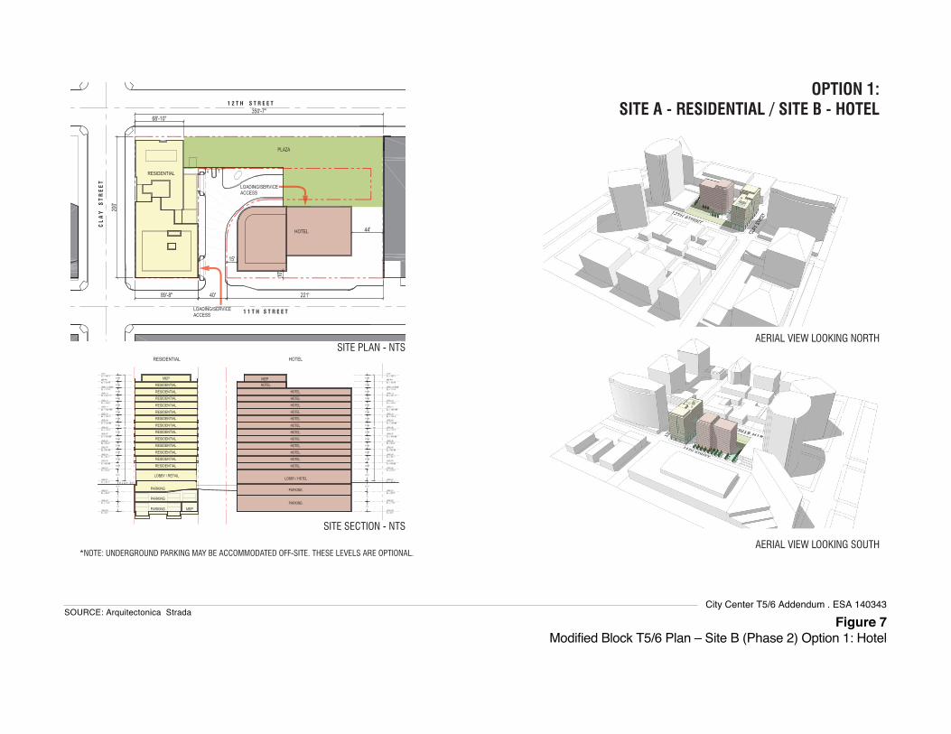
Figure 7Modified Block T5/6 Plan – Site B (Phase 2) Option 1: Hotel
SOURCE: Arquitectonica StradaCity Center T5/6 Addendum . ESA 140343
OPTION 1: SITE A - RESIDENTIAL / SITE B - HOTEL
AERIAL VIEW LOOKING SOUTH
AERIAL VIEW LOOKING NORTH
LOADING/SERVICE ACCESS
HOTEL
RESIDENTIAL
LOADING/SERVICE ACCESS
RESIDENTIAL HOTEL
SITE PLAN - NTS
*NOTE: UNDERGROUND PARKING MAY BE ACCOMMODATED OFF-SITE. THESE LEVELS ARE OPTIONAL.
SITE SECTION - NTS
PLAZA
JANUARY 23, 2015T-5/6 OAKLAND, CA 0.4DEVELOPMENT OPTION 1: RESI / HOTEL

Figure 8Modified Block T5/6 Plan – Site B (Phase 2) Option 1: Residential
SOURCE: Arquitectonica StradaCity Center T5/6 Addendum . ESA 140343
DEVELOPMENT OPTION 2: RESI / RESI
OPTION 2: SITE A - RESIDENTIAL / SITE B - RESIDENTIAL
AERIAL VIEW LOOKING SOUTH
AERIAL VIEW LOOKING NORTH
LOADING/SERVICE ACCESS
RESIDENTIAL B
RESIDENTIAL A
LOADING/SERVICE ACCESS
RESIDENTIAL A RESIDENTIAL B
SITE PLAN - NTS
PLAZA
*NOTE: UNDERGROUND PARKING MAY BE ACCOMMODATED OFF-SITE. THESE LEVELS ARE OPTIONAL.
SITE SECTION - NTS
JANUARY 23, 2015T-5/6 OAKLAND, CA 0.5

Figure 9Modified Block T5/6 Plan – Site B (Phase 2) Option 1: Office
SOURCE: Arquitectonica StradaCity Center T5/6 Addendum . ESA 140343
OPTION 3: SITE A - RESIDENTIAL / SITE B - OFFICE
AERIAL VIEW LOOKING SOUTH
AERIAL VIEW LOOKING NORTH
LOADING/SERVICE ACCESS
OFFICE
RESIDENTIAL
LOADING/SERVICE ACCESS
SITE PLAN - NTS
*NOTE: UNDERGROUND PARKING MAY BE ACCOMMODATED OFF-SITE. THESE LEVELS ARE OPTIONAL.
SITE SECTION - NTS
RESIDENTIAL OFFICE
PLAZA
JANUARY 23, 2015T-5/6 OAKLAND, CA 0.6DEVELOPMENT OPTION 3: RESI / OFFICE

1100 Clay Street CEQA AnalysisModified Block T5/6 Project
City Project No. ER‐15003 26 May 29, 2015 ESA Project No. 140343
Other Modified T5/6 Characteristics
Pedestrian Plaza and Art Park
The 12th Street portion of Site A would include a publicly accessible pedestrian plaza and “art park,”
developed on in the area that is currently the paved roof of the City Center Garage. As shown in
Figure 10, the pedestrian plaza would include both soft and hard landscaping, public art, and pedestrian‐
oriented commercial spaces for restaurant and/or retail use, potentially through shipping container
installation.
Parking and Circulation
Parking. Both buildings (Site A and Site B) would provide their own parking, except as specified below.
The Site A building would utilize up to 200 parking spaces in the City Center West Garage through a
license agreement with the City of Oakland, and/or provide between 150 and 180 parking spaces onsite in
up to three below‐grade levels in a combination of standard spaces and lift parking (see Figures 6
through Figure 8).
The project sponsor has submitted plans for Site A that show 188 parking spaces in three underground
building levels on Site A as an option. If the Site A spaces are provided on‐site, the 200 existing City
Center West Garage spaces may be included as part of the Site B parking if Site B is developed with the
Option 1 hotel, which would require 138 off‐street parking spaces. If Site B is developed with the Option
2 residential building, all the required parking for that use would be provided within Site B. If Site B is
developed with the Option 3 office building, no off‐street parking spaces would be required.
Site A would include long term bicycle parking for 61 bicycles on the ground level adjacent to the
residential building lobby, with direct access from both Clay and 11th Streets. Fifteen (15) short‐term
bicycle parking spaces would be provided along the sidewalks. Bicycle parking detail is not yet provided
for Site B.
Vehicular Access. Block T5/6 would continue to be accessed and egressed from the existing driveway
from 11th Street. Development on Site A would remove the existing exit‐only driveway from the City
Center Garage to Clay Street. Vehicles would access the Site A building garage and loading/service areas
from 11th Street, with the garage driveway located just before the City Center Garage entrance (see
Figure 5). While not yet detailed, vehicles would also access the Site B parking and loading/service areas
from the existing 11th Street driveway.
Pedestrian Access. Primary pedestrian access to the residential component on Site A would be through a
main lobby mid‐block on Clay Street. A secondary pedestrian access would also be provided on
11th Street. The proposed Site A building would be built to the property line and would widened the
sidewalks adjacent to the building. Development on Site B would be similarly developed, except that an
Option 1 hotel or an Option 2 residential building would have setback areas along the 11th Street
frontage, potentially for pedestrian/guest drop‐offs (see Figures 7 and 8, respectively).

Figure 10Modified Block T5/6 Plaza Plan – Site A (Phase 1)
SOURCE: Arquitectonica StradaCity Center T5/6 Addendum . ESA 140343
PAVINGCAFE SEATING GUARDRAIL GRASS HILL SEATING TRELLIS
0302 04 0501
A B C
01 02 03 04 05
KEY PLAN
N LANDSCAPE ELEMENTS L2 JANUARY 23, 2015
1100 CLAY OAKLAND, CA
1100 Clay Street CEQA AnalysisModified Block T5/6 Project
City Project No. ER‐15003 28 May 29, 2015 ESA Project No. 140343
Landscaping, Open Space and Tree Removal
For Phase 1, all 19 existing trees on Site A, as well as approximately six trees that exist north of the City
Center Garage entrance, would be removed to develop the residential building and accommodate
improved stormwater treatment areas, such as flow‐through planters. The approximately 15 remaining
trees on the project site would be removed to accommodate development of Site B in Phase 2.
For Phase 1, the proposed project would install 16 new street trees and bulb‐out plantings along the street
frontages of Site A, spaced at up to approximately every 25 feet, as well as 10 new trees along the street
edge of the proposed pedestrian plaza. In Phase 2, an additional 10 street trees would be added along the
11th street frontage.
Onsite, existing landscaping and approximately 25 new trees would be removed and replaced along the
internal driveways to the Site A and Site B buildings’ garages and loading/service areas, and near the
existing City Center Parking Garage and loading areas currently serviced by the 11th Street driveway.
Landscaping or other grass or planter areas would also be provided in the outdoor patio area on the
building roof of Site A and the public pedestrian plaza on 12th Street within Site A (described above). The
project would include an efficient irrigation system. No uplighting would be included onsite.
Sustainability and Efficiency
The project sponsor intends to meet LEED Silver standards and comply with the Green Building
ordinance and requirements. The project would optimize the efficiency of its building envelope and
through use of efficient lighting and HVAC systems to reduce domestic energy use. The project would
meet the newly implemented Building Energy Efficiency Standards and would exceed these standards as
prerequisite and additional points for LEED.
Construction and Phasing
The Modified Project for Block T5/6 involves two phases, as previously described. Phase 1 (Site A) is
scheduled to commence construction no later than 36 months after the City of Oakland approves the
Disposition and Development Agreement (DDA) for the site, which is estimated for mid 2015). The
second phase (Site B) is scheduled to commence construction no later than 60 months after City approval
of the DDA. Construction for each phase is anticipated to last a period of approximately twenty‐four
months.
Construction activities on the project site would consist of excavation and shoring, foundation and below‐
grade construction, and construction of buildings and finishing interiors. Excavation to depths ranging to
approximately 43 to 53 feet below grade (as measured from existing sidewalks) would be needed to
accommodate the development of Block T5/6 and would be required largely to accommodate the
potential underground parking levels on each site. Approximately 33,000 cubic yards of excavation
would be required for residential building on Site A or Site B Option 2, and approximately 8,000 cubic
yards would be excavated for the Option 1 hotel or Option 3 office buildings on Site B. Taken together,
development of Block T5/6 could involve 41,000 to 66,000 cubic yards of excavation.9 The soil to be
excavated consists predominately of sand, which can be excavated using conventional earth‐moving
equipment such as loaders and backhoes. No soils are anticipated to be imported to the site.
9 For conservative purposes in terms of environmental effects, a total of 66,000 cubic yards of excavation is assumed for Block T5/6
throughout the analysis in this Addendum.

1100 Clay Street CEQA AnalysisModified Block T5/6 Project
City Project No. ER‐15003 29 May 29, 2015 ESA Project No. 140343
Groundwater depth across the site ranges from approximately five to nine feet below ground surface,
and dewatering during excavation and construction would be required. Given the potential height of the
proposed buildings, pile driving would occur or be required.
Discretionary Project Approvals Requested The project sponsor requests, and proposed project would require, a number of discretionary actions/
approvals, including without limitation.
Actions by the City of Oakland Revised or Amended Preliminary PUD: A revised or amended Preliminary PUD to allow for a
mix of development of multifamily residential, hotel, and/or office use on the project site. The PUD
revision would also address a preliminary site plan, massing, and concept design for Site B, Phase
2. This would be a Bureau of Planning action.
Final PUD and Final Development Plan (FDP): For Site A, Phase 1, a Final PUD approval of final
development plans. Site B, Phase 2 would be subject to a Final PUD application at a later date, once
the project sponsor has determined the final use for Site B. This would be a Bureau of Planning
action.
Conditional Use Permit (CUP): A CUP to reduce the requisite parking, provided through a
combination, of on‐site and off‐site parking spaces at the developer’s choosing. The developer has
the right to lease up to 200 parking spaces at the City Center West Garage to satisfy the project’s
parking requirements. This would be a Bureau of Planning action.
Variance: A variance to reduce the required number of on‐site loading spaces from two to one.
This would be a Bureau of Planning action.
Tentative Parcel Map (TPM): TPM to match the site parcels to the development program. This
would be a Bureau of Planning action.
Tree Removal: Issuance of Tree Removal Permit. This would be a Public Works Tree Division action.
Building and other Discretionary Development Permits: Grading and other related onsite and
offsite work permits, and minor encroachment permits. This would be a Bureau of Building action.
Disposition and Development Agreement (DDA): Specifying the price and terms of payment for
the project site and development obligations. This would be a City Council action.
Actions by Other Agencies Bay Area Air Quality Management District (BAAQMD): Issuance of permits for installation and
operation of the emergency generator.
Regional Water Quality Control Board: Acceptance of a Notice of Intent to obtain coverage under
the General Construction Activity Storm Water Permit, and Notice of Termination after
construction is complete. Granting of required clearances to confirm that all applicable standards,
regulations, and conditions for all previous contamination at the site have been met.
East Bay Municipal Utility District (EBMUD): Approval of new service requests and new water
meter installations.
1100 Clay Street CEQA AnalysisModified Block T5/6 Project
City Project No. ER‐15003 30 May 29, 2015 ESA Project No. 140343
V. Summary of Findings An evaluation of the proposed project is provided in the CEQA Checklist in Section VI that follows. This
evaluation concludes that the Modified T5/6 Project qualifies for an addendum as well as an exemption
from additional environmental review. It is consistent with the development density and land use
characteristics established by the City of Oakland General Plan, and any potential environmental impacts
associated with its development were adequately analyzed and covered by the analysis in the 2000
Oakland City Center EIR and its four addenda, and in the applicable Program EIRs: the 1998 LUTE EIR,
the 2011 Redevelopment Plan Amendments EIR, and for the housing components of the proposed project,
the 2010 General Plan Housing Element Update EIR and 2014 Addendum.
The proposed project would be required to comply with the applicable mitigation measures identified in
the 2000 EIR, as updated and amended, and any applicable City of Oakland SCAs presented in
Attachment A to this document.10 With implementation of the applicable mitigation measures and SCAs,
the proposed project would not result in a substantial increase in the severity of previously identified
significant impacts in the 2000 EIR and its subsequent addenda, the applicable Program EIRs, or in any
new significant impacts that were not previously identified in any of those CEQA documents.
In accordance with California Public Resources Code Sections 21083.3, 21094.5, and 21166; and CEQA
Guidelines Sections 15183, 15183.3, 15162, 15164, 15168, and 15180, and as set forth in the CEQA Checklist
below, the proposed project qualifies for an addendum and one or more exemptions because the
following findings can be made:
Addendum. The analyses conducted and the conclusions reached in the 2000 EIR certified by the
Planning Commission on April 26, 2000, and last confirmed by the City Council in 2010 (EIR
Addendum #4), remain valid. The proposed project would not cause new significant impacts not
previously identified in the previously certified Program EIRs, or result in a substantial increase in
the severity of previously identified significant impacts. No new mitigation measures would be
necessary to reduce significant impacts. No changes have occurred with respect to circumstances
surrounding the Original Project that would cause significant environmental impacts to which the
proposed project would contribute considerably, and no new information has been put forward
that shows that the proposed project would cause significant environmental impacts. Therefore, no
supplemental environmental review is required in accordance with Public Resources Code
Section 21166, and CEQA Guidelines Sections 15162, 15164, as well as 15168 and 15180.
Community Plan Exemption. The proposed project would not result in significant impacts that
(1) are peculiar to the project or project site; (2) were not previously identified as significant project‐
level, cumulative, or offsite effects in the 2000 Oakland City Center EIR, its addenda, or in the
applicable Program EIRs: 1998 LUTE EIR, and for the housing components of the proposed project,
the 2010 General Plan Housing Element Update EIR and 2014 Addendum; or (3) were previously
identified as significant effects, but which—as a result of substantial new information not known at
the time the 2000 EIR or its addenda were prepared, or when the Program EIRs were certified—
would increase in severity beyond that described in those EIRs. Therefore, the proposed project
would meet the criteria to be exempt from further environmental review in accordance with Public
Resources Code Section 21083.3 and CEQA Guidelines Section 15183.
10 Throughout this document, except where necessary for clarity, “2000 EIR” encompasses the Initial Study, Draft EIR, Final EIR,
and each subsequent addendum for the City Center Project.
1100 Clay Street CEQA AnalysisModified Block T5/6 Project
City Project No. ER‐15003 31 May 29, 2015 ESA Project No. 140343
Qualified Infill Exemption. The proposed project would not cause any new specific effects on the
environment that were not already analyzed in the 2000 Oakland City Center EIR, its addenda, or
in the applicable Program EIRs: the 1998 LUTE EIR, and for the housing components of the proposed
project, the 2010 General Plan Housing Element Update EIR and 2014 Addendum. Further, the
proposed project would not cause any new specific effects on the environment that are more
significant than previously analyzed in the 2000 EIR, its addenda, or the aforementioned previously
certified applicable Program EIRs. The effects of the proposed project have been addressed in the
previous Program EIRs, and no further environmental documents are required in accordance with
Public Resources Code Section 21094.5 and CEQA Guidelines Section 15183.3.
Program EIRs and Redevelopment Projects. The proposed project would not result in substantial
changes or involve new information not already analyzed in the 2011 Redevelopment Plan
Amendments EIR, in which the Modified T5/6 Project is identified as part of the series of actions
named in the cumulative analysis of that EIR. The effects of the proposed project have been
addressed in that EIR and no further environmental documents are required in accordance with
CEQA Guidelines Sections CEQA Guidelines Sections 15168 and 15180.
Each of the above findings provides a separate and independent basis for CEQA compliance.
Darin Ranelletti
Environmental Review Officer Date
1100 Clay Street CEQA AnalysisModified Block T5/6 Project
City Project No. ER‐15003 32 May 29, 2015 ESA Project No. 140343
VI. CEQA Checklist
Overview
The analysis in this CEQA Checklist provides a summary of the potential environmental impacts that
may result from adoption and implementation of the Oakland City Center Project, specifically for
Modified Block T5/6, as evaluated in the certified 2000 Oakland City Center Project EIR.11 The analysis in
this CEQA Checklist also summarizes the impacts and findings of Program EIRs that covered, specifically
or as part of the cumulative analyses, the environmental effects of the Oakland City Center Project
encompassing the Modified T5/6 Project and that are still applicable for the proposed project. As
previously indicated, the Program EIRs are referred to collectively throughout this CEQA Analysis as
“Previous CEQA Documents” and include the 1998 Land Use and Transportation Element EIR, the 2011
Central District Urban Renewal Plan (or Redevelopment Plan) Amendments EIR, and for the housing
components of the proposed project, the 2010 General Plan Housing Element Update EIR and 2014
Addendum. Given the timespan between the preparations of these EIRs, there are variations in the
specific environmental topics addressed and significance criteria, however, as discussed above in Section
II and throughout this Checklist, the overall environmental effects identified in each are largely the same;
any notable differences are noted.
Several mitigation measures identified in the 2000 EIR have since been adopted by the City as SCAs for
all projects. All mitigation measures, as modified herein, and SCAs identified for the Modified T5/6
Project are presented in Appendix A to this document, which is incorporated by reference into this CEQA
Analysis. Because the SCAs are mandatory City requirements, the impact analysis for the proposed
project assumes that they will be imposed and implemented, which the project sponsor has agreed to do
or ensure as part of the proposed project. If this CEQA Checklist or its attachments inaccurately identifies
or fails to list a mitigation measure or SCA, the applicability of that mitigation measure or SCA to the
proposed project is not affected.
This CEQA Checklist hereby incorporates by reference the discussion and analysis of all potential
environmental impact topics as presented in the certified 2000 Oakland City Center Project, its addenda,
and the Program EIRs. The significance criteria from the 2000 EIR, have been consolidated and
abbreviated in this CEQA Checklist for administrative purposes; where appropriated, the significance
criteria are updated to reflect the current City of Oakland significance criteria that were established after
the 2000 EIR and that now apply to the proposed project.
This CEQA Checklist provides a determination of whether the proposed project would result in:
Equal or Less Severity of Impact Previously Identified in the Previous CEQA Documents;
Substantial Increase in Severity of Previously Identified Significant Impact in the Previous CEQA
Documents; or
New Significant Impact.
11 Reference to the “Oakland City Center Project EIR” or the “2000 EIR” encompasses the Initial Study, Draft EIR, Final EIR, and
each of four subsequent addendum for the City Center Project.

1100 Clay Street CEQA AnalysisModified Block T5/6 Project
City Project No. ER‐15003 33 May 29, 2015 ESA Project No. 140343
Where the severity of the impacts of the proposed project would be the same as or less than the severity
of the impacts described in the Previous CEQA Documents, the checkbox for “Equal or Less Severity of
Impact Previously Identified in Previous CEQA Documents” is checked.
If the checkbox for “Substantial Increase in Severity of Previously Identified Significant Impact in
Previous CEQA Documents” or “New Significant Impact” were checked, there would be significant
impacts that are:
Peculiar to project or project site (per CEQA Guidelines Sections 15183 or 15183.3);
Not identified in the previous 1998 LUTE EIR or 2010 Housing Element Update EIR and 2014
Addendum (per CEQA Guidelines Sections 15183 or 15183.3), including offsite and cumulative
impacts (per CEQA Guidelines Section 15183);
Due to substantial changes in the project (per CEQA Guidelines Section 15162 and 15168);
Due to substantial changes in circumstances under which the project will be undertaken (per
CEQA Guidelines Sections 15162 and 15168); or
Due to substantial new information not known at the time the Previous CEQA Documents were
certified (per CEQA Guidelines Sections 15162, 15168, 15183, or 15183.3).
None of the aforementioned conditions were found for the proposed project, as demonstrated throughout
the following CEQA Checklist and in its supporting attachments (Attachments B through D) that
specifically describe how the proposed project meets the criteria and standards specified in the CEQA
Guidelines sections identified above.
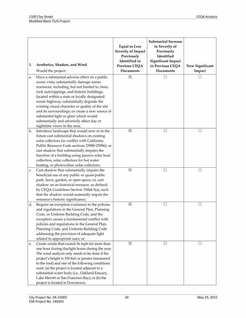
1100 Clay Street CEQA AnalysisModified Block T5/6 Project
City Project No. ER‐15003 34 May 29, 2015 ESA Project No. 140343
1. Aesthetics, Shadow, and Wind
Would the project:
Equal or Less
Severity of Impact
Previously
Identified in
Previous CEQA
Documents
Substantial Increase
in Severity of
Previously
Identified
Significant Impact
in Previous CEQA
Documents
New Significant
Impact
a. Have a substantial adverse effect on a public
scenic vista; substantially damage scenic
resources, including, but not limited to, trees,
rock outcroppings, and historic buildings,
located within a state or locally designated
scenic highway; substantially degrade the
existing visual character or quality of the site
and its surroundings; or create a new source of
substantial light or glare which would
substantially and adversely affect day or
nighttime views in the area;
☒ ☐ ☐
b. Introduce landscape that would now or in the
future cast substantial shadows on existing
solar collectors (in conflict with California
Public Resource Code sections 25980‐25986); or
cast shadow that substantially impairs the
function of a building using passive solar heat
collection, solar collectors for hot water
heating, or photovoltaic solar collectors;
☒ ☐ ☐
c. Cast shadow that substantially impairs the
beneficial use of any public or quasi‐public
park, lawn, garden, or open space; or, cast
shadow on an historical resource, as defined
by CEQA Guidelines Section 15064.5(a), such
that the shadow would materially impair the
resource’s historic significance;
☒ ☐ ☐
d. Require an exception (variance) to the policies
and regulations in the General Plan, Planning
Code, or Uniform Building Code, and the
exception causes a fundamental conflict with
policies and regulations in the General Plan,
Planning Code, and Uniform Building Code
addressing the provision of adequate light
related to appropriate uses; or
☒ ☐ ☐
e. Create winds that exceed 36 mph for more than
one hour during daylight hours during the year.
The wind analysis only needs to be done if the
project’s height is 100 feet or greater (measured
to the roof) and one of the following conditions
exist: (a) the project is located adjacent to a
substantial water body (i.e., Oakland Estuary,
Lake Merritt or San Francisco Bay); or (b) the
project is located in Downtown.
☒ ☐ ☐

1100 Clay Street CEQA AnalysisModified Block T5/6 Project
City Project No. ER‐15003 35 May 29, 2015 ESA Project No. 140343
Project Analysis
Scenic Vistas, Scenic Resources, and Visual Character (Criterion 1a)
Visual quality (scenic vistas, scenic resources, visual character, and light and glare), was analyzed in each
of the Program EIRs considered throughout this CEQA Analysis. The 1998 LUTE EIR, the 2010 Housing
Element Update EIR and 2014 Addendum, and the 2011 Redevelopment Plan Amendments EIR found that
the effects to visual quality would be less than significant. The Redevelopment Plan EIR and the Housing
Element EIR cited applicable SCAs that would ensure the less‐than‐significant visual quality effects. The
LUTE EIR identified mitigation measures that would reduce the potential effects to less than significant,
which are functionally equivalent to the SCAs.
The 2000 City Center Project EIR determined that potential impacts of the Original Project to visual
quality would be less than significant; no mitigation measures were necessary. The 2000 EIR analysis was
based on the City Center Project’s development of four high‐rise buildings, ranging in maximum heights
of 21 stories (306 feet) to 31 stories (440 feet), on four blocks that compose the Original Project. Two of the
four City Center Project blocks have since been developed: Block T9 at 21 stories (approximately 306 feet)
and Block T10 at 8 stories (approximately 80 feet), the latter being built at substantially lower height than
originally analyzed. The two remaining City Center Project blocks remain undeveloped: Block T5/6 and
Block T12.
The existing conditions and immediate surroundings of Block T5/6 are substantially unchanged from the
2000 EIR, except for the development of Block T9 immediately west of the site, across Clay Street. Block
T5/6 has no buildings and contains grass, landscaping, and an L‐shaped driveway lane to the City Center
Parking Garage and loading/service docks. The existing landscaping and trees on portions of Block T5/6
were planted by the Oakland Redevelopment Agency as an interim improvement several years prior to
2000 and have since matured, providing some existing scenic resource value to the area. A portion of
Block T5/6 is the paved roof over the south portion of the City Center Parking Garage. (See Figures 4a
and 4b of this document.)
When compared to the Original Project, the Modified T5/6 Project would develop two buildings instead
of one. The maximum height of buildings on the site would be up to 14 stories (approximately 150 feet),
which is 12 stories (approximately 240 feet) less than previously analyzed. The location and orientation of
the proposed buildings on the site would be toward the south (11th Street) and west (Clay Street), similar
to that previously considered. However, the building proposed on Site A would front the full length of
the Clay Street block (about 200 feet between 11th and 12th Streets), whereas the model analyzed in the
2000 EIR fronted about 140 feet of the Clay Street block.
The 2000 EIR presented a generalized massing model of the Original Project building analyzed for Block
T5/6, which was a 440‐foot tall rectangular building covering most of the site, except with a set back from
12th Street, as described above.12 While not detailed in the 2000 EIR, all of the Original Project buildings
would include street‐level commercial uses. The building setbacks and street‐level commercial uses
throughout the developments would allow for landscaped plazas and “provide visual relief in scale,
form, colors, and textures at street level from the height and mass of the structures,” a pattern established
by adjacent high‐rise development, like 1111 Broadway (immediately east of Block T5/6) and as
developed with Block T9 (immediately west of Block T5/6, across Clay Street). Moreover, as anticipated in
12 Oakland City Center Project Draft EIR, Figures IV.E‐4 through IV‐E.9, provided in Appendix A to this document.

1100 Clay Street CEQA AnalysisModified Block T5/6 Project
City Project No. ER‐15003 36 May 29, 2015 ESA Project No. 140343
the 2000 EIR, a plaza and garden area was developed between the existing 1111 Broadway building and
the project building on Block T5/6, which was would further offset the loss of existing landscaping on this
block.
As shown in Figure 6 through Figure 10 of this document, the Site A Phase 1 building, site layout, and
pedestrian plaza proposed by the Modified Block T5/6 Project would result in development compatible
with the visual character and patterns in this portion of Downtown. The substantially lower building
height now proposed for Block T5/6 would result in less obstruction of views of the sky than previously
estimated, but would still align with the varied building heights Downtown. The 2000 EIR acknowledged
limited views in the area because of the dense, multi‐story development covering most blocks; existing
views across Block T5/6 are obstructed by the development on all adjacent blocks, and effect to any views
identified in the 2000 EIR would be less with the lower building height proposed for the site. While visual
quality is inherently subjective, the visual impacts of the Modified T5/6 Project would be less severe than
those discussed in the 2000 EIR and would remain less than significant. The visual impacts of the project
would also be similar to, or less severe than, those identified in the Program EIRs considered in this
analysis.
Development on Block T5/6 would be required to comply with City of Oakland SCAs related to
landscaping, street frontages, landscape maintenance, utility undergrounding, public right‐of‐way
improvements, and lighting plans.
Shadow (Criteria 1b through 1d)
Except for the LUTE EIR, each of the Program EIRs found less‐than‐significant shadow effects, assuming
incorporation of applicable SCAs. The LUTE EIR identified mitigation measures to reduce potential
shadow effects to less than significant.
The 2000 EIR determined that the Original Project would cast shadow to the west, north, and east of the
four project blocks, and that potential shadow impacts would be less than significant; no mitigation
measures were necessary. The shadow analysis of the Original Project evaluated development on all four
blocks, each model with a 440‐foot rectangular building, including on Block T5/6. A subsequent shadow
analysis was conducted for Addendum #3, which shows the potential shadow effects of a conceptual
building on Block T5/6 in context with the other City Center Project development and surroundings, in
particular the buildings that were built since the 2000 EIR analysis on Block T9 and underway at the time
on T10. 13
Both the EIR and the Addendum #3 analyses focused on the Original Project’s potential effects on nearby
public open space. These include Lafayette Square Park located approximately one block or 500 feet west
of Block T5/6, south of 11th Street; and the historic Pardee Home and Garden and Preservation Park
located approximately two blocks or 1,000 feet west of Block T5/6, both north and south of 12th Street.
The previous analyses found that shadow from the modeled 440‐foot tall building on Block T5/6 would
cast shadow on Lafayette Square Park during the morning hours except in late spring and summer,
general overlapping the shadow cast by the building on Block T9. However, neither building would
substantially affect use of the park since neither building casts shadow on the park after mid‐morning.
13 Oakland City Center Project Addendum #3, Figures 3 through 8, provided in Appendix A to this document.
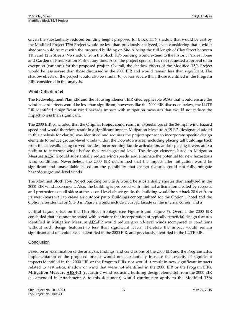
1100 Clay Street CEQA AnalysisModified Block T5/6 Project
City Project No. ER‐15003 37 May 29, 2015 ESA Project No. 140343
Given the substantially reduced building height proposed for Block T5/6, shadow that would be cast by
the Modified Project T5/6 Project would be less than previously analyzed, even considering that a wider
shadow would be cast with the proposed building on Site A being the full length of Clay Street between
11th and 12th Streets. No shadow from the Block T5/6 building would extend to the historic Pardee Home
and Garden or Preservation Park at any time. Also, the project sponsor has not requested approval of an
exception (variance) for the proposed project. Overall, the shadow effects of the Modified T5/6 Project
would be less severe than those discussed in the 2000 EIR and would remain less than significant. The
shadow effects of the project would also be similar to, or less severe than, those identified in the Program
EIRs considered in this analysis.
Wind (Criterion 1e)
The Redevelopment Plan EIR and the Housing Element EIR cited applicable SCAs that would ensure the
wind hazard effects would be less than significant, however, like the 2000 EIR discussed below, the LUTE
EIR identified a significant wind hazards impact with mitigation measures that would not reduce the
impact to less than significant.
The 2000 EIR concluded that the Original Project could result in exceedances of the 36‐mph wind hazard
speed and would therefore result in a significant impact. Mitigation Measure AES‐F.2 (designated added
in this analysis for clarity) was identified and requires the project sponsor to incorporate specific design
elements to reduce ground‐level winds within the Downtown area, including placing tall buildings back
from the sidewalk, using curved facades, incorporating facade articulation, and/or placing towers atop a
podium to interrupt winds before they reach ground level. The design elements listed in Mitigation
Measure AES‐F.2 could substantially reduce wind speeds, and eliminate the potential for new hazardous
wind conditions. Nevertheless, the 2000 EIR determined that the impact after mitigation would be
significant and unavoidable based on the possibility that design features could not fully mitigate
hazardous ground‐level winds.
The Modified Block T5/6 Project building on Site A would be substantially shorter than analyzed in the
2000 EIR wind assessment. Also, the building is proposed with minimal articulation created by recesses
and protrusions on all sides; at the second level above grade, the building would be set back 20 feet from
its west (rear) wall to create an outdoor patio. Buildings conceptualized for the Option 1 hotel and the
Option 2 residential on Site B in Phase 2 would include a curved façade on the internal corner, and a
vertical façade offset on the 11th Street frontage (see Figure 6 and Figure 7). Overall, the 2000 EIR
concluded that it cannot be stated with certainty that incorporation of typically beneficial design features
identified in Mitigation Measure AES‐F.2 would reduce ground‐level winds (compared to conditions
without such design features) to less than significant levels. Therefore the impact would remain
significant and unavoidable, as identified in the 2000 EIR, and previously identified in the LUTE EIR.
Conclusion
Based on an examination of the analysis, findings, and conclusions of the 2000 EIR and the Program EIRs,
implementation of the proposed project would not substantially increase the severity of significant
impacts identified in the 2000 EIR or the Program EIRs, nor would it result in new significant impacts
related to aesthetics, shadow or wind that were not identified in the 2000 EIR or the Program EIRs.
Mitigation Measure AES‐F.2 (regarding wind‐reducing building design elements) from the 2000 EIR
(as amended in Attachment A to this document) would continue to apply to the Modified T5/6

1100 Clay Street CEQA AnalysisModified Block T5/6 Project
City Project No. ER‐15003 38 May 29, 2015 ESA Project No. 140343
Project, which would also be required to implement City of Oakland SCAs related to landscaping,
street frontages, landscape maintenance, utility undergrounding, public right‐of‐way improvements,
and lighting plans, as identified in Attachment A. For reference, these are AES‐1 through AES‐9, and
SCA BIO‐1.
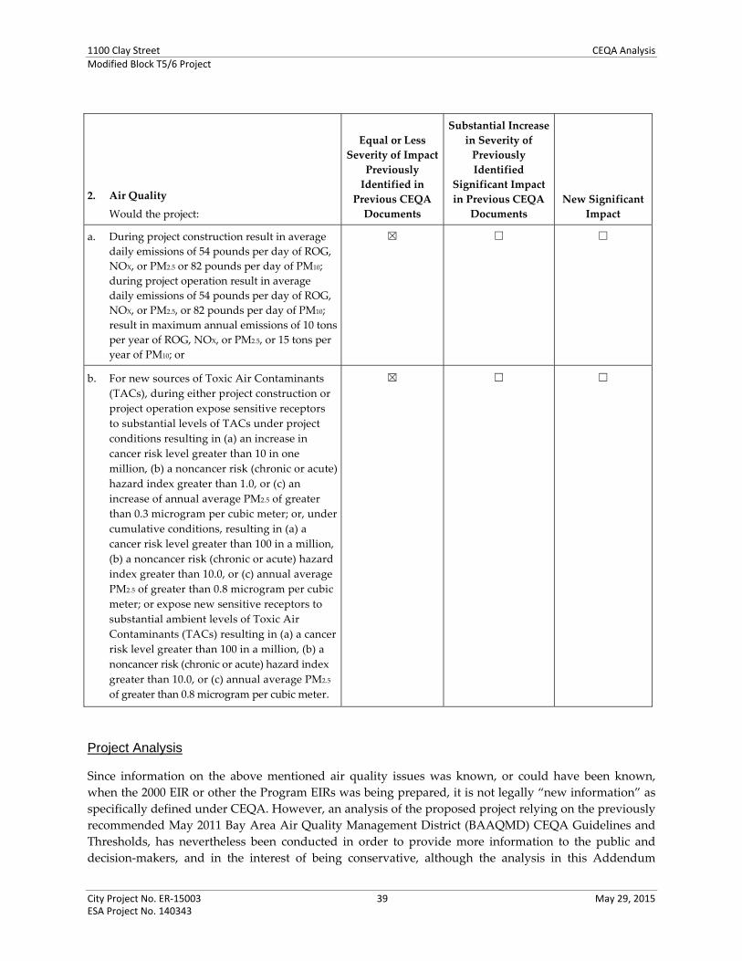
1100 Clay Street CEQA AnalysisModified Block T5/6 Project
City Project No. ER‐15003 39 May 29, 2015 ESA Project No. 140343
2. Air Quality
Would the project:
Equal or Less
Severity of Impact
Previously
Identified in
Previous CEQA
Documents
Substantial Increase
in Severity of
Previously
Identified
Significant Impact
in Previous CEQA
Documents
New Significant
Impact
a. During project construction result in average
daily emissions of 54 pounds per day of ROG,
NOX, or PM2.5 or 82 pounds per day of PM10;
during project operation result in average
daily emissions of 54 pounds per day of ROG,
NOX, or PM2.5, or 82 pounds per day of PM10;
result in maximum annual emissions of 10 tons
per year of ROG, NOX, or PM2.5, or 15 tons per
year of PM10; or
☒ ☐ ☐
b. For new sources of Toxic Air Contaminants
(TACs), during either project construction or
project operation expose sensitive receptors
to substantial levels of TACs under project
conditions resulting in (a) an increase in
cancer risk level greater than 10 in one
million, (b) a noncancer risk (chronic or acute)
hazard index greater than 1.0, or (c) an
increase of annual average PM2.5 of greater
than 0.3 microgram per cubic meter; or, under
cumulative conditions, resulting in (a) a
cancer risk level greater than 100 in a million,
(b) a noncancer risk (chronic or acute) hazard
index greater than 10.0, or (c) annual average
PM2.5 of greater than 0.8 microgram per cubic
meter; or expose new sensitive receptors to
substantial ambient levels of Toxic Air
Contaminants (TACs) resulting in (a) a cancer
risk level greater than 100 in a million, (b) a
noncancer risk (chronic or acute) hazard index
greater than 10.0, or (c) annual average PM2.5
of greater than 0.8 microgram per cubic meter.
☒ ☐ ☐
Project Analysis
Since information on the above mentioned air quality issues was known, or could have been known,
when the 2000 EIR or other the Program EIRs was being prepared, it is not legally “new information” as
specifically defined under CEQA. However, an analysis of the proposed project relying on the previously
recommended May 2011 Bay Area Air Quality Management District (BAAQMD) CEQA Guidelines and
Thresholds, has nevertheless been conducted in order to provide more information to the public and
decision‐makers, and in the interest of being conservative, although the analysis in this Addendum
1100 Clay Street CEQA AnalysisModified Block T5/6 Project
City Project No. ER‐15003 40 May 29, 2015 ESA Project No. 140343
evaluates air quality using both the 2000 EIR thresholds (based upon BAAQMD 1999 CEQA Air Quality
Guidelines) and the BAAQMD May 2011 CEQA Guidelines and Thresholds, significance determinations
are based on the thresholds from the 2000 EIR. Nevertheless, the City will impose its SCAs and
previously approved mitigation measures from the 2000 EIR, as detailed below.
Construction and Operational Emissions (Criterion 2a)
The Redevelopment Plan EIR and the Housing Element EIR found that emissions associated with
construction and operations resulting from increased criteria pollutants from resulting development
would result in less‐than‐significant effects, including with adherence to mitigation measures or SCAs.
Specifically, the Redevelopment Plan EIR and the Housing Element EIR cited applicable SCAs that would
ensure these less‐than‐significant effects, including dust/PM10 and odors, as well as consistency with the
applicable regional clean air plan. The LUTE EIR identified mitigation measures that would address
operational emissions effects to less than significant, including specifically in the Downtown area.
However, the LUTE EIR found significant cumulative effects regarding increased criteria pollutants from
increased traffic regionally, and the identified mitigation measures would not reduce the effect, which
would remain significant and unavoidable after implementation of the mitigation.
The 2000 EIR for the Original Project found that the potential impact of development of the Original
Project (all blocks) would result in significant but mitigatable impacts to construction and operational air
quality emissions (like the Redevelopment Plan EIR and the Housing Element EIR), as well as a
significant cumulative air quality emissions impact (like the LUTE EIR). As analyzed below, the Modified
T5/6 Project would result in similar impacts as those previously identified.
Construction Air Emissions
Assumptions for Construction Emissions
The analysis below used the following assumptions to calculate average daily construction emissions
associated with a worst‐case construction scenario for the proposed project:
Worst case excavation (all residential scenario) totaling 66,000 cubic yards of exported soil;
The length of the various construction phases (e.g., demolition, grading, building, etc.) was
CalEEMod default values;
The amount and types of construction equipment used for each phase and the number of off‐road
vehicle trips were based on CalEEMod defaults;
The footprint lot size of the proposed project (Sites A and B) input into CalEEMod 1.25 acres;
Construction of 262 units (Site A) and 205,800 square feet of office (Site B, Option 3), which is
considered the most impactful scenario of the proposed project for purposes of assessing air quality
impacts ‐ that is the scenario that would generate the most vehicle trips and construction activity.
Two year construction period, for each phase.
Analysis of Construction Emissions
The average daily construction‐related emissions for the proposed project, based on the assumptions
above, are presented in Table AIR‐1. As shown in the table, annual average daily construction emissions
for the proposed project would not exceed the City’s Thresholds for ROG NOX, PM10 or PM2.5. These

1100 Clay Street CEQA AnalysisModified Block T5/6 Project
City Project No. ER‐15003 41 May 29, 2015 ESA Project No. 140343
thresholds were developed to represent a cumulatively considerable contribution to regional air quality,
and as such, represent not only a project level threshold but a cumulative threshold as well.
TABLE AIR-1 UNMITIGATED EMISSIONS FROM CONSTRUCTION (average lbs per day)a
Construction Year (phase) ROG NOx PM10 PM2.5
Project
Average Daily Construction Emissions 23.8 41.9 2.0 1.9
City of Oakland Thresholds 54 54 82 54
Significant (Yes or No)? No No No No
a Project construction emissions estimates were made using CalEEMod, version 2013.2.2. Emissions are average daily pounds per day during the two year construction period.
SOURCE: ESA, 2015.
The 2000 EIR for the Original Project analyzed construction‐related air emissions relative to the
methodology and thresholds of the Bay Area Air Quality Management District (BAAQMD) contained in
its 1999 CEQA Air Quality Guidelines which did not require quantification of construction‐related
emissions or identify quantitative thresholds for assessing construction‐related emissions. As previously
stated, the 2000 EIR identified a less‐than‐significant impact with respect to construction‐related
emissions, after the inclusion of mitigation measures (Mitigation Measure C.1) to control fugitive dust
and ensure equipment maintenance. These measures are now incorporated into current City of Oakland
SCAs for all projects within the City of Oakland, and therefore would apply to the proposed project.
Mitigation Measure C.1 is replaced with the current City of Oakland SCA (as shown in Attachment A to
this document). Therefore, the proposed project would have an equal or less severe construction‐related
air quality impact compared to that previously identified in the 2000 EIR or the other the Program EIRs.
Operational Air Emissions
Assumptions for Operational Emissions
The analysis below used the following assumptions to calculate the daily operational emissions
associated with a worst‐case construction scenario for the proposed project:
The vehicle trip generation rates that were input into CalEEMod (Version 2013.2.2) account for the
2000 Bay Area Travel Survey (BATS) modal split adjustment factor that is required by the City of
Oakland for near‐transit developments;
The operational emissions generated assumed a default number of fireplaces. All fireplaces were
assumed to be gas‐fired. No wood burning fireplaces or woodstoves were assumed;
All other inputs in CalEEMod were based on model default values.
Two backup diesel generators were assumed pursuant to California Building Code Requirements
for buildings of this height. The generators were assumed to have a rating of 300 kW‐hr, a Tier 2
engine and to be operated for maintenance purposes 50 hours per year or about 1 hour per test day.

1100 Clay Street CEQA AnalysisModified Block T5/6 Project
City Project No. ER‐15003 42 May 29, 2015 ESA Project No. 140343
Analysis of Operational Emissions
The daily operational emissions for the proposed project, based on the assumptions above, are presented
in Table AIR‐2. As shown in the table, annual average daily regional emissions for the proposed project
would not exceed the City’s thresholds for ROG, NOX, PM10 or PM2.5. As with the construction thresholds,
these thresholds were developed to represent a cumulatively considerable contribution to regional air
quality and as such, represent not only a project level threshold but a cumulative threshold as well.
TABLE AIR-2 UNMITIGATED EMISSIONS FROM OPERATION (lbs per day)a
ROG NOx PM10 PM2.5
Project Area Source Emissions 12.28 0.25 0.40 0.40
Energy Emissions 0.15 1.32 0.10 0.10
Project Vehicle Emissionsb 8.47 23.30 11.95 3.40
Backup Diesel Generator 2.02 24.80 1.76 1.76
Total Emissions 22.92 49.67 14.21 5.66
City of Oakland Thresholds 54 54 82 54
Significant (Yes or No)? No No No No a Project operational emissions estimates were made using CalEEMod, version 2013.2.2. b The vehicle trip rates used to calculate the emissions accounts for mode split and internal capture as recommended by the City of Oakland for
projects located in dense, urban environments such as the Project site. SOURCE: ESA, 2014.
The 2000 EIR for the Original Project analyzed operational air emissions relative to the methodology and
thresholds of the BAAQMD contained in its 1999 CEQA Air Quality Guidelines which had less stringent
thresholds for ROG and NOx (80 pounds per day), a more stringent threshold for PM10 (80 pounds per
day), and no threshold for PM2.5.14 The 2000 EIR identified a significant impact with respect to operational
emissions of NOx upon the completion of Block T9 as well as Block T5/6 (assumed 2005).15 Block T5/6
alone in the 2000 EIR had emissions that were below the 1999 thresholds as well as under existing
thresholds. The analysis in the 2000 EIR did not consider emissions from maintenance operation of
generators, as is considered in the proposed project analysis reported in Table AIR‐2.
The 2000 EIR identified mitigation measures (Mitigation Measures C.2a and C.2b) addressing
Transportation Control Measures and 12th Street BART Station improvements to reduce emissions to a
less‐than‐significant level. Mitigation Measure C.2a is replaced with the current City of Oakland SCA
regarding Transportation Demand Management (TDM) (as shown in Attachment A to this document).
The SCA regarding TDM applies to all projects within the City of Oakland, therefore it would still apply
to the proposed project even though the Modified T5/6 Project would not have the significant operational
emissions impact. Mitigation Measure C.2b would not apply to the Modified T5/6 Project. The proposed
project would have an equal or less severe operational air quality impact than previously identified in the
2000 EIR or the Program EIRs.
14 The cited thresholds remained consistent across the addenda prepared to the 2000 EIR. 15 The 2000 EIR analysis considered emissions from the then‐anticipated year of completion of the first building, Block T9 (2001);
the then‐anticipated year of completion of Block T9 and T5/6 (2005); as well as emissions for all four City Center Project blocks at the time completion was initially estimated (2010).

1100 Clay Street CEQA AnalysisModified Block T5/6 Project
City Project No. ER‐15003 43 May 29, 2015 ESA Project No. 140343
Cumulative Air Emissions
The 2000 EIR also conservatively identified a significant cumulative air quality impact for the Original
Project, presuming that its significant but mitigable project‐levels of ROG and NOx (ozone precursor
emissions) would be a “considerable” contribution to the region’s nonattainment for ozone and state
standard for PM10 (state standard only).
As shown in Table AIR‐2, the Modified T5/6 Project would not result in project‐level exceedances of
criteria pollutants. Also, counter to the statement in the 2000 EIR that the Original Project would be fully
developed by 2010, Blocks T5/6 and T12 remain undeveloped and would occur in years of improved
background air conditions. Regardless, this analysis conservatively assumes that the proposed projects
could still have a considerable contribution to regional conditions. The current City of Oakland SCA
regarding TDM (which replaces Mitigation Measure C.2a from the 2000 EIR), would apply to the
proposed project’s conservatively‐assessed contribution to the cumulative impact, which would remain
significant and unavoidable.
Toxic Air Contaminants (Criterion 2b)
Emissions associated with construction and operations resulting from increased criteria pollutants from
development that could occur under each of the d Program EIRs considered throughout this analysis were
found to result in less‐than‐significant effects, either with adherence to mitigation measures or SCAs. The
Redevelopment Plan EIR and the Housing Element EIR cited applicable SCAs that would ensure these
less‐than‐significant effects, including dust/PM10 and odors, as well as consistency with the applicable
regional clean air plan. The LUTE EIR identified mitigation measures that would address each of these
topics and reduce the effect to less than significant, including specifically in the Downtown area. The
LUTE EIR also identified mitigation measures to address increased regional emissions of criteria air
pollutants, but determined that the effect would remain significant and unavoidable after consideration
of the mitigation.
The 2000 EIR for the Original Project analyzed air emissions relative to the methodology and thresholds
of the BAAQMD contained in its 1999 CEQA Air Quality Guidelines which did not require quantification
of cumulative health risks and screening tools for analyzing such cumulative risks were not available
from BAAQMD at that time. As presented in the analysis below, the Modified T5/6 Project would not
result in a new significant impact with respect to cumulative toxic air contaminants (TACs) impacts.
The LUTE EIR (1998) did not quantify or address cumulative health risks, as such analysis was not
required when that EIR was prepared. The Redevelopment Plan EIR (2011), and the Housing Element
EIR (2010 and 2014) did conduct cumulative health risk assessments and, as identified for the Modified
T5/6 Project, identified significant and unavoidable impacts, after the consideration of SCAs.
Assumptions and Area Sources for Health Risk
Since the previous analysis in the 2000 EIR did not address health risk associated with TACs, this
following background is provided. TACs are types of air pollutants that can cause health risks. TACs do
not have ambient air quality standards, but are regulated using a risk‐based approach. This approach
uses a health risk assessment to determine what sources and pollutants to control as well as the degree of
control. The health risk assessment, presented in the analysis below, considers exposure to toxic
substances and human health risks from exposure to toxic substances is estimated, based on the potency
1100 Clay Street CEQA AnalysisModified Block T5/6 Project
City Project No. ER‐15003 44 May 29, 2015 ESA Project No. 140343
of the toxic substances. Such an assessment evaluates chronic, long‐term effects, calculating the increased
risk of cancer as a result of exposure to one or more TACs.
Additionally, the City’s CEQA significance thresholds require that new projects containing sensitive
receptors (such as residences) be evaluated to determine whether those receptors would be exposed to
health risks from existing nearby sources of TACs. When siting new sensitive receptors, existing TAC
sources located within 1,000 feet including, but not limited to, stationary sources, freeways, and major
roadways (10,000 or greater vehicles per day) should be considered.16 The BAAQMD provides a publicly
available inventory of TAC‐related health risks for permitted stationary sources throughout the
San Francisco Bay Area Air Basin as well as for freeways. The inventory presents community risk and
hazards from screening tools and tables that are intentionally conservative. The screening‐level risk
factors derived from the BAAQMD’s tools are intended to indicate whether additional review related to
the impact is necessary and are not intended to be used to assess actual risk for all projects.
Analysis of Health Risk
Construction Impact. Regarding construction TACs emissions, BAAQMD developed screening tables for
commercial and residential land use development projects that estimate screening distances from
sensitive receptors sufficient to avoid exposure to substantial construction‐related health risks. For
development sites of less than 3 acres in area, a screening distance of 100 meters (328) feet is identified as
sufficient to avoid a construction‐related TAC impact. Block T5/6 is approximately 1.25 acres in area and
is located over 500 feet from the nearest sensitive receptor (Domain Apartments north of Jefferson Street
and 13th Street). Therefore, potential impact of the proposed project regarding exposure to construction
related health risks would be less than significant.
Project‐Level Operations Impact. The two backup diesel generators assumed for the proposed project
(given its high‐rise height, as previously described under Assumptions for Operational Emissions), would be
the only new source of TACs associated with the proposed project. The 2000 EIR did not envision the
potential for back‐up generators and no analysis was performed of health risk impacts associated with
new sources of TACs. The BAAQMD would not issue a permit to operate to any new generators that
would increase cancer risks at receptors in excess of 10 in one million after implementation of Best
Available Control Technology for Toxics, so the proposed project’s generators would not exceed
acceptable risk levels. Therefore, the health risks impact of the proposed project on the environment
would be less than significant.
Cumulative Impact. Regarding exposure of new sensitive receptors to existing and new sources of TACs,
the health risk analysis contained herein relies on the BAAQMD’s conservative screening‐level tool to
screen out low‐emitting existing sources of TACs that pose no substantial threat to increased cancer risk
exposure. According to BAAQMD’s conservative screening‐level tool for Alameda County, there are 15
stationary TAC sources within 1,000 feet of the Block T5/6, all of which are backup generators. According
to the BAAQMD’s intentionally conservative estimates, some of these sources have screening‐level cancer
risks up to 177 in one million at the property line of the source.
ESA conducted refinements to these screening values to account for distance between receptors at Block
T5/6 and the stationary TAC sources within 1,000 feet of Block T5/6. Table AIR‐3 presents the results of
16 CEQA requires the analysis of potential adverse effects of a project on the environment. Potential effects of the environment on a
project are legally not required to be analyzed or mitigated under CEQA. However, this analysis nevertheless assesses potential effects of “the environment on the project” in order to provide information to decision‐makers.

1100 Clay Street CEQA AnalysisModified Block T5/6 Project
City Project No. ER‐15003 45 May 29, 2015 ESA Project No. 140343
this refined, project‐specific, screening effort that includes the risks posed by roadway traffic on
Broadway and the proposed project’s backup diesel generators. As shown, the cumulative cancer risks
for new receptors (residents) of the proposed project (Site A, or Site B Option 2) would be below the
significance criterion of 100 in one million. As such, a Health Risk Assessment in accordance with the
California Air Resources Board and the Office of Environmental Health and Hazard Assessment
requirements was neither required nor conducted. The cumulative impact would be less than significant.
TABLE AIR-3 CUMULATIVE HEALTH IMPACTS FOR NEW RECEPTORS
Site # Facility Type Address
Cancer Risk (persons per
million) Chronic Hazard
Impact
PM2.5 Concentration
(µg/m3)
18912 Generator 427 14th Street 0.61 <0.001 <0.001
14837 Generator 1000 Broadway 3.85 0.002 <0.001
16836 Generator 1111 Broadway 4.26 0.001 0.008
13308 Generator 1221 Broadway 0.08 <0.001 0.0133
18110 Generator 1330 Broadway 0.66 <0.001 <0.001
12765 Generator 1330 Broadway 1.44 0.001 0.001
17607 Generator 1333 Broadway NA NA NA
10345 Generator 564 14th Street 0 0 0
14423 Generator 475 14th Street 6.99 0.003 0.002
16713 Generator 475 14th Street 0 0 0
16835 Generator 505 14th Street 1.29 <0.001 <0.001
16837 Generator 525 14th Street 12.4 0.004 0.003
16749 Generator 1301 Clay Street 24.84 0.009 0.099
16838 Generator 1300 Clay Street 4.58 0.002 0.008
14534 Generator 555 12th Street 32.56 0.011 0.058
Roadway Sources
Broadwaya 1.15 0.002 0.043
Cumulative Impacts 94.71 0.033 0.235
City of Oakland Significance Criteria (new receptor) 100 10 0.8
Potentially Significant Impact? No No No
a Risks and concentrations from roadway traffic on Broadway are for an assumed distance of 500 feet from the edge of the nearest travel lane of a
north-south directional roadway in Alameda County. Broadway has an existing AADT of 15,600 per Fehr & Peers. Risks presented assume AADT of 20,000. (AADTs for 11th and 12th Street are less than 10,000 and therefore no analysis is required for these roadways)
NA = Not an active source per BAAQMD Source: BAAQMD, 2014; ESA, 2015.
As shown in Table AIR‐3, the proposed project would not result in exposure to substantial levels of TACs
resulting in a cumulative cancer risk level greater than 100 in a million, thus the impact is less‐than‐
significant. Including consideration of roadway traffic on Broadway, the cumulative cancer risks for new
receptors (residents) of the proposed project would be less than 100 in one million. No mitigation
measure is required.

1100 Clay Street CEQA AnalysisModified Block T5/6 Project
City Project No. ER‐15003 46 May 29, 2015 ESA Project No. 140343
Conclusion
Based on an examination of the analysis, findings, and conclusions of the 2000 EIR and the Program EIRs,
as well as new analysis presented above per current thresholds, implementation of the Modified T5/6
Project would not result in a new significant impact regarding operational air quality emissions or,
conservatively, a cumulative air quality impact identified in the 2000 EIR. The analysis above also
determines that the proposed project would not result in a new significant impact regarding construction
emissions, which was not addressed in the 2000 EIR or the Program EIRs. Also, based on the health risk
analysis above, implementation of the proposed project would not result in a new significant impact
related to construction, operational, or cumulative TAC emissions, which also were not addressed in the
2000 EIR, but were addressed in the subsequent Redevelopment Plan EIR and Housing Element EIR and
Addendum, and found to be significant and unavoidable.
No mitigation measures are required. Mitigation Measure C.1 from the 2000 EIR is now replaced with
current City of Oakland SCA regarding construction‐related emissions controls, and Mitigation Measure
C.2a from the 2000 EIR is now replaced with current City of Oakland SCA involving the preparation and
implementation of TDM plans. Both current City of Oakland SCAs are identified in Attachment A to this
document. For reference, the applicable SCAs are SCA AIR‐1 and SCA AIR‐2 (previously Mitigation
Measures C.1 and C.2a, respectively).

1100 Clay Street CEQA AnalysisModified Block T5/6 Project
City Project No. ER‐15003 47 May 29, 2015 ESA Project No. 140343
3. Biological Resources
Would the project:
Equal or Less
Severity of Impact
Previously
Identified in
Previous CEQA
Documents
Substantial Increase
in Severity of
Previously
Identified
Significant Impact
in Previous CEQA
Documents
New Significant
Impact
a. Have a substantial adverse effect, either
directly or through habitat modifications, on
any species identified as a candidate, sensitive,
or special status species in local or regional
plans, policies, or regulations, or by the
California Department of Fish and Wildlife or
U.S. Fish and Wildlife Service;
Have a substantial adverse effect on any riparian
habitat or other sensitive natural community
identified in local or regional plans, policies,
regulations or by the California Department of
Fish and Game or U.S. Fish and Wildlife Service;
Have a substantial adverse effect on federally
protected wetlands (as defined by Section 404
of the Clean Water Act) or state protected
wetlands, through direct removal, filling,
hydrological interruption, or other means;
Substantially interfere with the movement of
any native resident or migratory fish or
wildlife species or with established native
resident or migratory wildlife corridors, or
impede the use of native wildlife nursery sites;
☒ ☐ ☐
b. Fundamentally conflict with the City of
Oakland Tree Protection Ordinance (Oakland
Municipal Code [OMC] Chapter 12.36) by
removal of protected trees under certain
circumstances; or
Fundamentally conflict with the City of
Oakland Creek Protection Ordinance (OMC
Chapter 13.16) intended to protect biological
resources.
☒ ☐ ☐
Project Analysis
Special‐Status Species, Wildlife Corridors, Riparian and Sensitive Habitat, Wetlands, Tree and Creek
Protection (Criteria 3a and 3b)
Each of the Program EIRs considered in this analysis found that the effects to biological resources would
be less than significant, specifically with the incorporation of City of Oakland SCAs identified in the

1100 Clay Street CEQA AnalysisModified Block T5/6 Project
City Project No. ER‐15003 48 May 29, 2015 ESA Project No. 140343
Redevelopment Plan EIR and the Housing Element EIR and Addendum. No mitigation measures were
necessary.
The 2000 EIR found that the potential impact of the Original Project on biological resources would also be
less than significant; no mitigation measures were necessary.
As was described in the previous analysis, the Oakland City Center Project blocks are located in the fully
developed urban area of Downtown; this remains the existing condition for Block T5/6. Block T5/6 does
not contain vegetation and hydrology conditions suitable for sustaining wetlands, nor are any known
special status species or sensitive habitats, including those that could support migratory fish or birds,
located on the site. The existing landscaping and trees on portions of Block T5/6 were planted by the
Oakland Redevelopment Agency as an interim improvement several years prior to 2000 and have since
matured. However, this vegetation is not connected to other nearby natural habitats, and therefore would
not constitute a wildlife corridor. There are no natural sensitive communities in the area.
However, although not considered in the 2000 EIR, existing trees on the project site could be nursery sites
for nesting birds. In addition, the buildings proposed for Block T5/6 could cause harm to birds by
increasing bird collisions with buildings. A City of Oakland SCA pertaining to reducing bird collisions
with buildings would reduce potential impacts to birds by constructing features in compliance with Best
Management Practice strategies to limit bird strikes.
As it was when assessed in the 2000 EIR, the approximately 40 trees on Block T5/6 are “Protected Trees,”
per Oakland’s Protected Tree Ordinance. That previous analysis discussed that the development of Block
T5/6 in particular would require approval of a tree removal permit prior to the issuance of building
permits, consistent with standard City practices and regulations. This requirement is now directed by
City of Oakland SCAs related to the removal and replacement of trees, tree protection during
construction, and protection of nesting birds during the breeding season. Compliance with these SCAs
would protect natural resources from potential degradation that could result from development of the
proposed project. A relevant requirement of the tree removal permit is that the project must include
specific planting for the removal of any native species. As shown in Figure 5 and Figure 10 in this
document, the proposed project would introduce new trees onsite as well as along the project street
frontage and in a new pedestrian plaza on Site A.
Conclusion
Based on an examination of the analysis, findings, and conclusions of the 2000 EIR and the Program EIRs
considered in this analysis, implementation of the proposed project would not substantially increase the
severity of significant impacts identified in the 2000 EIR or the previously mentioned Program EIRs. Nor
would the proposed project result in new significant impacts related to biological resources that were not
identified in the 2000 EIR or the other Program EIRs. The 2000 EIR did not identify any mitigation
measures related to biological resources, and none would be needed for the proposed project. City of
Oakland SCAs related to tree removal and replacement, bird protection, erosion control, stormwater
management, and hazardous materials, identified in Attachment A to this document would apply to the
proposed project. For reference, these are SCA BIO‐1 through SCA BIO‐4, SCA GEO‐1, SCA HAZ‐1,
SCA HYD‐1 and HYD‐1, and SCA HYD‐6.

1100 Clay Street CEQA AnalysisModified Block T5/6 Project
City Project No. ER‐15003 49 May 29, 2015 ESA Project No. 140343
4. Cultural Resources
Would the project:
Equal or Less
Severity of Impact
Previously
Identified in
Previous CEQA
Documents
Substantial Increase
in Severity of
Previously
Identified
Significant Impact
in Previous CEQA
Documents
New Significant
Impact
a. Cause a substantial adverse change in the
significance of an historical resource as defined in
CEQA Guidelines Section 15064.5. Specifically, a
substantial adverse change includes physical
demolition, destruction, relocation, or alteration
of the resource or its immediate surroundings
such that the significance of the historical
resource would be “materially impaired.” The
significance of an historical resource is
“materially impaired” when a project demolishes
or materially alters, in an adverse manner, those
physical characteristics of the resource that
convey its historical significance and that justify
its inclusion on, or eligibility for inclusion on an
historical resource list (including the California
Register of Historical Resources, the National
Register of Historic Places, Local Register, or
historical resources survey form (DPR Form 523)
with a rating of 1‐5);
☒ ☐ ☐
b. Cause a substantial adverse change in the
significance of an archaeological resource
pursuant to CEQA Guidelines Section 15064.5;
☒ ☐ ☐
c. Directly or indirectly destroy a unique
paleontological resource or site or unique
geologic feature; or
☒ ☐ ☐
d. Disturb any human remains, including those
interred outside of formal cemeteries.
☒ ☐ ☐
Project Analysis
Historical Resources (Criterion 4a)
The Redevelopment Plan EIR, which addresses much of the oldest part of Downtown Oakland, identified
a significant impact to historical resources that would occur with development anticipated in the
Redevelopment Plan Amendments EIR, even with the implementation of mitigation measures identified
in that Redevelopment Plan EIR. Therefore, the impact to historic resources would be significant and
unavoidable. The LUTE EIR also identified mitigation measures to address the potentially significant
impacts to historic resources, however, the identified mitigation measures, which included amending the
Zoning Regulations to incorporate new preservation regulations and incentives, as well as developing
and adopting design guidelines for Landmarks and Preservation Districts, would reduce the impact to

1100 Clay Street CEQA AnalysisModified Block T5/6 Project
City Project No. ER‐15003 50 May 29, 2015 ESA Project No. 140343
less than significant. The Housing Element EIR identifies City of Oakland SCAs pertaining to historic
resources, and finds a less‐than‐significant impact.
The 2000 EIR also found that the potential impact of development of the Original Project on historical
resources would be less than significant. There are three historic districts in the area of the Original
Project; these include the Grove Street‐Lafayette Square Residential District, the Old Oakland District,
and the Downtown District. In addition to the historic districts, two designations of the S‐7 Preservation
Combining Zones generally overlap with each of the nearby districts.
Block T5/6 does not have existing structures, nor is it located near the historic resources identified in the
2000 EIR that could potentially be affected by the City Center Project. Previous analysis discussed that
“the nearby historic districts are identified as isolated remnants of what was once greater Downtown
Oakland, defined by their isolation from the remainder of the historic Downtown. Additionally, these
districts are isolated by existing land use patterns.” Development of Block T5/6, like the Original Project,
would neither alter the character‐defining elements of the historic districts, nor impair the physical
characteristics that convey the significance of the districts. Changes in land use and design of the
Modified Block T5/6, compared to those discussed in the 2000 EIR or the Program EIRs considered in this
analysis, would not result in new, or new or substantially more severe impacts, on historic resources than
were identified in the 2000 EIR or the Program EIRs.
Archaeological and Paleontological Resources and Human Remains (Criteria 4b through 4d)
Each of the Program EIRs considered in this analysis found that the effects to archaeological and
paleontological resources and human remains would be less than significant, specifically with the
incorporation of City of Oakland SCAs, except that the LUTE EIR (and the 2000 EIR, as discussed below)_
identified mitigation measures would reduce the effects to archaeological resources to less than
significant.
The 2000 EIR found that the potential impact of development of the Original Project on archaeological
and paleontological resources and human remains would be less than significant with the
implementation of mitigation measures identified in the Initial Study.17
The proposed project would involve grading and excavation activities up to depths of approximately 40
feet below grade to construct the buildings and associated below‐grade parking either in Phase 1 on Site
A, or in Phase 2 on Site B. Based on the results of the Geotechnical Report prepared for the proposed
project, the site is underlain with approximately five to seven feet of loose to dense silty clayey sand and
the near‐surface soil is not expansive. Below the initial layer of sand lies about 22 to 32 feet of dense to
very dense silty sand known as the Merritt sand. Stiff to hard clayey silt and silty clay with interlayered
sand underlie the Merritt sand. Borings indicate the presence of groundwater at approximately five to
nine feet below ground surface to the west of the site and approximately seven to 11 feet below ground
surface to the south of the site.
In addition, according to the Phase 1 Environmental Site Assessment, the project site was previously
developed as a service station, with various surrounding uses, including parking lots and garages, gas
stations, and commercial service uses, and as updated from the 2000 EIR, the previous development on
17 The Initial Study to the 2000 EIR did not identify designators for mitigation measures.

1100 Clay Street CEQA AnalysisModified Block T5/6 Project
City Project No. ER‐15003 51 May 29, 2015 ESA Project No. 140343
the site was cleared approximately 35 years ago, and the site has since been excavated for the below‐
grade City Center Parking Garage.
The previous analysis acknowledged the potential for discovery of archaeological and paleontological
resources and/or human remains during construction and excavation on the project site. The mitigation
measures identified in the 2000 EIR, including one pertaining to archaeological resources that was
updated in subsequent addenda to the EIR, are now incorporated in current City of Oakland SCAs, as
listed in Attachment A to this document. The applicable City of Oakland SCAs would ensure that
archaeological resources are recovered and that appropriate procedures are followed in the event of
accidental discovery; would require a qualified paleontologist to document a discovery, would require
that appropriate procedures be followed in the event of a discovery, and would ensure that the
appropriate procedures for handling and identifying human remains are followed. Adherence to the
applicable City of Oakland SCAs would reduce potential risks of impact to these resources to less than
significant.
Conclusion
Based on an examination of the analysis, findings, and conclusions of the 2000 EIR and the Program EIRs
considered throughout this analysis, implementation of the proposed project would not substantially
increase the severity of significant impacts identified in the 2000 EIR or the other Program EIRs, nor
would it result in new significant impacts related to cultural resources that were not identified in the 2000
EIR or the other Program EIRs. The Modified T5/6 Project would not result in impacts to historical
resources. Further, the proposed project would implement City of Oakland SCAs that replace the
mitigation measures previously identified for the Original Project to address the accidental discovery of
archeological and paleontological resources and human remains, identified in Attachment A to this
document. For reference, these are SCA CUL‐1, SCA CUL‐2 and SCA CUL‐3.

1100 Clay Street CEQA AnalysisModified Block T5/6 Project
City Project No. ER‐15003 52 May 29, 2015 ESA Project No. 140343
5. Geology, Soils, and Geohazards
Would the project:
Equal or Less
Severity of Impact
Previously
Identified in
Previous CEQA
Documents
Substantial Increase
in Severity of
Previously
Identified
Significant Impact
in Previous CEQA
Documents
New Significant
Impact
a. Expose people or structures to substantial risk
of loss, injury, or death involving:
Rupture of a known earthquake fault, as
delineated on the most recent Alquist‐Priolo
Earthquake Fault Zoning Map or Seismic
Hazards Map issued by the State Geologist
for the area or based on other substantial
evidence of a known fault;
Strong seismic ground shaking;
Seismic‐related ground failure, including
liquefaction, lateral spreading, subsidence,
collapse; or
Landslides;
☒ ☐ ☐
b. Be located on expansive soil, as defined in
Section 1802.3.2 of the California Building
Code (2007, as it may be revised), creating
substantial risks to life or property; result in
substantial soil erosion or loss of topsoil,
creating substantial risks to life, property, or
creeks/waterways.
☒ ☐ ☐
Project Analysis
Seismic Hazards, Expansive Soils, and Soil Erosion (Criterion 5a and 5b)
Each of the Program EIRs considered in this analysis found that the effects to geology, soils, and
geohazards would be less than significant with the incorporation of City of Oakland SCAs. No mitigation
measures were necessary.
The 2000 EIR found that the potential impact of development of the Original Project on geology, soils and
geohazards would be less than significant, with the project sponsor’s adherence to local and state
regulations.
The Original Project site is located approximately 3.5 miles southwest of the Hayward Fault and is
outside of the Alquist‐Priolo Geologic Hazards Special Studies Zone. The 2000 EIR described that all of
the City Center blocks were located in soil zone II which may experience a variety of types of ground
failure due to ground motion, particularly if there is strong seismic activity. However, the 2000 EIR also
determined that development of the Original Project would not result in any significant impacts with
respect to rupture of a known earthquake fault, ground shaking, or seismic‐related ground failure
1100 Clay Street CEQA AnalysisModified Block T5/6 Project
City Project No. ER‐15003 53 May 29, 2015 ESA Project No. 140343
because development would adhere to standard City practices employed to ensure that all buildings are
designed and built in conformance with state and local seismic requirements.
Current City of Oakland SCAs now incorporate these requirements and would ensure that development
of the proposed project on Block T5/6 would avoid and minimize potential geologic impacts through
compliance specifically with local and state regulations governing design and construction practices,
including the California Building Code. Implementation of City of Oakland SCAs that require the
preparation of soils and geotechnical reports specifying generally accepted and appropriate engineering
techniques would reduce potential impacts to less‐than‐significant levels.
As reported in the 2000 EIR, the Original Project sites are located in an area designated as least
susceptible to landslides; they do not have contributing factors such as slopes over 15 percent or a history
of landslide problems. Moreover, the sites are relatively flat and developed in the Downtown urban area
that is built‐out or paved, landscaped, and served by an existing storm drain system. Block T5/6
continues to have these characteristics and therefore would not result in significant impacts with respect
to landslides. The proposed project would not result in substantial risks to life or property.
The 2000 EIR determined that development of the Original Project would result in less‐than‐significant
impacts regarding substantial soil erosion or loss of topsoil because of the project applicant’s required
compliance with standard City practices. These practices are now incorporated in current City of Oakland
SCAs requiring the project applicant’s preparation and submittal of an erosion control plan and
landscaping plans to address erosion during and after construction. The proposed project on Block T5/6
(Phase 1 Site A) would require excavation of up to 66,000 cubic yards of soil, as described in the Project
Description (Section IV of this document) and therefore would require a grading permit from the City. In
addition to the requirements of the grading permit, adherence to existing City of Oakland SCAs would
ensure that development of the proposed project on Block T5/6 would minimize erosion and
sedimentation during all phases of the project through installation of project landscaping and storm
drainage facilities, both of which shall be designed to meet applicable regulations.
The soil characterization of Block T5/6 has not changed since the 2000 EIR. As reported there for the
Original Project, and in the Geotechnical Report prepared for the proposed project, the site is in an area
characterized as Urban Land‐Danville complex, which have some development limitations. These
limitations would be addressed pursuant to requirements specified in the site‐specific Geotechnical
Report for the proposed project, and measures discussed in the previous analysis are now incorporated
into current City of Oakland SCAs that would minimize potential geohazards impacts and require the
preparation of soils and geotechnical reports specifying generally accepted and appropriate engineering
techniques and compliance with local and state regulations and codes.
As discussed in the 2000 EIR, development of the Original Project would occur on sites served by the
existing sewer system; development of Block T5/6 would not involve septic tanks or alternative
wastewater disposal.
Conclusion
Based on an examination of the analysis, findings, and conclusions of the 2000 EIR and the Program EIRs
considered in this analysis, implementation of the proposed project would not substantially increase the
severity of significant impacts identified in the 2000 EIR or the other Program EIRs, nor would it result in
new significant impacts related to geology, soils, and geohazards that were not identified in the 2000 EIR

1100 Clay Street CEQA AnalysisModified Block T5/6 Project
City Project No. ER‐15003 54 May 29, 2015 ESA Project No. 140343
or the other Program EIRs. The proposed project would implement City of Oakland SCAs that
incorporate the regulatory requirements addressed in the Original Project to address soil erosion and
sedimentation control in particular, as well as City of Oakland SCAs to address other potential seismic
and geotechnical hazards, as identified in Attachment A to this document. For reference, these are SCA
GEO‐1, SCA GEO‐2, SCA GEO‐3, and SCA HYD‐4.
1100 Clay Street CEQA AnalysisModified Block T5/6 Project
City Project No. ER‐15003 55 May 29, 2015 ESA Project No. 140343
6. Greenhouse Gas and Climate Change
Would the project:
Equal or Less
Severity of Impact
Previously
Identified in
Previous CEQA
Documents
Substantial Increase
in Severity of
Previously
Identified
Significant Impact
in Previous CEQA
Documents
New Significant
Impact
a. Generate greenhouse gas emissions, either
directly or indirectly, that may have a significant
impact on the environment, specifically:
For a project involving a land use
development, produce total emissions of
more than 1,100 metric tons of CO2e
annually AND more than 4.64 metric tons of
CO2e per service population annually. The
service population includes both the
residents and the employees of the project.
The project’s impact would be considered
significant if the emissions exceed BOTH the
1,100 metric tons threshold and the
4.6 metric tons threshold. Accordingly, the
impact would be considered less than
significant if the project’s emissions are
below EITHER of these thresholds.
☒ ☐ ☐
b. Fundamentally conflict with an applicable plan,
policy, or regulation adopted for the purposes of
reducing greenhouse gas emissions.
☒
Project Analysis
Climate change and greenhouse gas emissions were not expressly addressed in the 2000 EIR, nor in the
1998 LUTE EIR, for reasons described below. However, since information on climate change and
greenhouse gas emissions was known, or could have been known, in 2000, it is not legally “new
information” as specifically defined under CEQA and thus is not legally required to be analyzed as a part
of this Addendum. However, an analysis of the proposed project using the previously recommended
May 2011 BAAQMD CEQA Guidelines and Thresholds has been conducted to provide more information
to the public and decision‐makers, and in the interest of being conservative. Thus, although the analysis
in this CEQA Checklist evaluates climate change and greenhouse gas emissions, there is no resulting
significant CEQA impact. Nevertheless, the City will impose its SCAs.
Greenhouse Gas Emissions (Criterion 6a)
The 2011 Redevelopment Plan EIR and the 2010 Housing Element EIR and 2014 Addendum included
GHG emissions and impacts analyses, as these documents were prepared after both former Governor
Schwarzenegger’s 2005 Executive Order S‐3‐05 that sets forth a series of target dates by which statewide
emissions of GHGs need to be progressively reduced as well as California’s landmark Assembly Bill 32 in
2006. Both of these Program EIRs identified less‐than‐significant impacts with the incorporation of
numerous applicable City of Oakland SCAs. No mitigation measures were necessary.

1100 Clay Street CEQA AnalysisModified Block T5/6 Project
City Project No. ER‐15003 56 May 29, 2015 ESA Project No. 140343
As previously discussed under 2. Air Quality, the analysis of the Modified T5/6 Project considers the
proposed project scenario that is considered the most impactful for purposes of assessing GHG
emissions; that is the scenario that would generate the most vehicle trips and construction activity: Site A,
residential + Site B Option 3, office.18
The Modified T5/6 Project would not result in a significant effect (cumulative) relating to GHG emissions,
as analyzed below. Both BAAQMD and the California Air Pollution Control Officers Association
(CAPCOA) consider GHG impacts to be exclusively cumulative impacts, in that no single project could,
by itself, result in a substantial change in climate. Therefore, the evaluation of GHG emissions impacts
evaluates whether the proposed project would make a considerable contribution to cumulative climate
change effects.
Construction GHG Emissions
The CalEEMod model run for the construction emissions associated with the proposed project (under 2. Air
Quality, above) also calculated the GHG emissions that would be generated by construction activities of the
proposed project. As shown in Table GHG‐1, construction‐related emissions would total 1,012 metric tons
of CO2 equivalents (CO2e) during the peak construction year. Annualized over an assumed project life of 40
years, construction‐related GHG emissions would be 25.3 metric tons per year of CO2e. These emissions are
factored into the total operational GHG emissions calculation below to determine significance.
TABLE GHG-1 GHG EMISSIONS FROM OPERATION (metric tons per year)a,b
Project Component CO2e
Project
Area Source Emissions 11.99
Energy Emissions 798.73
Mobile Emissions 1,967.27
Backup Generator 2.10
Solid Waste 141.89
Water and Wastewater 94.07
Annualized Construction Emissions (Over 40 Years) 25.3
Total Increase 3,041
Total Increase without Mobile Sources 1,074
City of Oakland Threshold 1,100
Total Emissions per Service Population (498 residents) 2.16
City Emissions per Service Population Threshold 4.6
Significant? No
a Project operational emissions estimates were made using CalEEMod, version 2013.2. b The GHG analysis relied on inputs from the Project Concept Plans that indicated a maximum of 262
residential units for Site A (498 residents). Service population would be more than this, depending on the land use developed on Site B. Analysis based only on Site A service population yields conservative results.
18 Up to 262 residential units on Site A (Phase 1) and up to 205,800 square feet of Option 3 office use on Site B (Phase 2).

1100 Clay Street CEQA AnalysisModified Block T5/6 Project
City Project No. ER‐15003 57 May 29, 2015 ESA Project No. 140343
Operational GHG Emissions
The proposed project would generate GHG emissions from many of the same sources as presented in air
quality Tables AIR‐1 and AIR‐2 (under 2. Air Quality, above). Additionally, GHGs would be generated
indirectly by increased electrical demand, increased water and wastewater demand, and increased solid
waste generation.
The total operational GHG emissions for the proposed project are presented in Table GHG‐1. This table
presents the project‐related GHG emissions from all sources and assesses the impact relative to City
thresholds. As discussed below (see Transit Priority Project), and Attachments C and D to this document, the
proposed project meets the criteria for a residential or mixed use “transit priority project,” and is located
within a “Regional Center” Priority Development Area (PDA) pursuant to the Plan Bay Area, which
represents the Sustainable Communities Strategy (SCS) for the greater San Francisco Bay Area (MTC, 2013).
Environmental documents for such projects , need not analyze global warming impacts resulting from cars
and light duty trucks. A lead agency should consider whether such projects may result in GHGs from other
sources, however, consistent with the CEQA Guidelines. Consequently, if the project meets the
requirements of a transit priority project, its mobile source need not be included in the assessment of GHG
impacts. For this reason, Table GHG‐1 presents the project‐related GHG emissions without the mobile
emissions, as permitted per CEQA guidelines Section 15183.5 (c).
As shown in Table GHG‐1, the proposed project would not exceed the threshold of 1,100 metric tons of
CO2e per year and also would not exceed the City’s 4.6 metric tons of CO2e per service population
threshold. Therefore, the GHG emission impact would be less than significant. The City’s GHG reduction
plan SCA would not be triggered since neither of the significance thresholds is exceeded. Numerous other
City of Oakland SCAs that would contribute to minimizing potential GHG emissions from construction
and operations of development projects would apply to the proposed project; they pertain to alternative
transportation facilities (bicycles and BART), construction equipment emissions, transportation demand
management, construction waste reduction and recycling, as well as California Green Building Standards.
Consistency with GHG Emissions Plans and Policies (Criterion 6b)
The Modified T5/6 Project would comply with the Oakland Energy and Climate Action Plan, current City
Sustainability Programs, and General Plan policies and regulations regarding GHG reductions and other
local, regional and statewide plans, policies and regulations that are related to the reduction of GHG
emissions and relevant to the proposed project.
Specifically, the proposed project would also be consistent with the State’s Updated Climate Change
Scoping Plan and the City of Oakland’s Energy and Climate Action Plan in that it will include a number of
sustainability design features. The proposed project intends to meet LEED Silver standards and comply
with the Green Building ordinance and requirements. It will optimize the efficiency of the building
envelopes and, through use of efficient heating, ventilation, and air conditioning (HVAC) and lighting
systems, reduce domestic energy use compared to traditional development. The proposed project will also
meet the newly implemented Building Energy Efficiency Standards and will exceed these standards as a
prerequisite of attaining additional points for LEED certification. Additionally, the proposed project is
located within a “Regional Center” Priority Development Area (PDA) pursuant to the Plan Bay Area, which
represents the Sustainable Communities Strategy (SCS) for the greater San Francisco Bay Area; as discussed

1100 Clay Street CEQA AnalysisModified Block T5/6 Project
City Project No. ER‐15003 58 May 29, 2015 ESA Project No. 140343
below and in Attachment D to this document, the proposed project meets all conditions for qualification as
a transit priority project with respect to the SCS, as discussed below.
Transit Priority Project
As introduced above, per CEQA Guidelines Section 15183.5 (c), environmental documents for certain
residential and mixed use projects and transit priority projects, as defined in Section 21155 of the Public
Resources Code, that are consistent with the general use designation, density, building intensity and
applicable policies specified for the project area in an applicable SCS or alternative planning strategy need
not analyze global warming impacts resulting from cars and light duty trucks. A lead agency should
consider whether such projects may result in GHGs from other sources, however, consistent with the CEQA
Guidelines. Consequently, if the project meets the requirements of a transit priority project, its mobile
source emissions need not be included in the assessment of GHG impacts.
Section 21155 of the California Public Resources Code defines transit priority projects as projects which:
1. Contain at least 50 percent residential use, based on total building square footage and, if the project
contains between 26 percent and 50 percent nonresidential uses, a floor area ratio of not less than
0.75;
2. Provide a minimum net density of at least 20 dwelling units per acre; and
3. Be located within one‐half mile of a major transit stop or high‐quality transit corridor included in a
regional transportation plan. A major transit stop is as defined in Section 21064.3, except that, for
purposes of this section, it also includes major transit stops that are included in the applicable
regional transportation plan. For purposes of this section, a high quality transit corridor means a
corridor with fixed route bus service with service intervals no longer than 15 minutes during peak
commute hours. A project shall be considered to be within one‐half mile of a major transit stop or
high‐quality transit corridor if all parcels within the project have not more than 25 percent of their
area farther than one‐half mile from the stop or corridor and if not more than 10 percent of the
residential units or 100 units, whichever is less, in the project are farther than one‐half mile from
the stop or corridor.
The project proposes a minimum of 236,613 square feet of residential uses and a maximum of
205,800 square feet of non‐residential (office) uses (53 percent residential use) with a minimum floor area
ratio of 4.34 (236,613/54,500). So, the proposed project meets condition (1) above for qualification as a transit
priority project. The project proposes a minimum of 262 residential units on a parcel of 1.25 acre, which is
equivalent to 210 dwelling units per acre. Consequently, the proposed project meets condition (2) above for
qualification as a transit priority project.
Finally, a major transit stop is defined in Section 21064.3 of the California Public Resources Code as a rail
transit station, a ferry terminal served by either a bus or rail transit service, or the intersection of two or
more major bus routes with a frequency of service interval of 15 minutes or less during the morning and
afternoon peak commute period. An entrance to the 12th Street City Center BART entrance (11th and
Broadway) is approximately 700 feet from the midpoint of Block T5/6. Other transit lines and major
transfer points are along Broadway within one to three blocks from Block T5/6. Consequently, the
proposed project meets all three conditions above for qualification as a transit priority project. Therefore,
1100 Clay Street CEQA AnalysisModified Block T5/6 Project
City Project No. ER‐15003 59 May 29, 2015 ESA Project No. 140343
pursuant to Section 15183.5 (c) of the CEQA Guidelines, the mobile source emissions of the project need
not be included in the assessment of GHG impacts in the environmental document.
Conclusion
Based on the analysis above, implementation of the Modified T5/6 Project would not result in a
significant impact regarding GHG emissions or compliance with applicable plans, policies, or regulations
adopted for the purposes of reducing greenhouse gas emission. No mitigation measures or City of
Oakland SCAs related to GHG emissions or plan consistency are necessary to ensure a less‐than‐
significant impact with the proposed project. However, the implementation of other mitigation measures
and City of Oakland SCAs that apply to the construction and operation of the proposed project would help
minimize GHG emissions, as identified in Attachment A to this document. For reference, these are
Mitigation Measures TRA‐B.5 and TRA‐B.6. Applicable SCAs are SCA AIR‐1, SCA AIR‐2, SCA UTIL‐1,
and SCA UTIL‐2.

1100 Clay Street CEQA AnalysisModified Block T5/6 Project
City Project No. ER‐15003 60 May 29, 2015 ESA Project No. 140343
7. Hazards and Hazardous Materials
Would the project:
Equal or Less
Severity of Impact
Previously
Identified in
Previous CEQA
Documents
Substantial Increase
in Severity of
Previously
Identified
Significant Impact
in Previous CEQA
Documents
New Significant
Impact
a. Create a significant hazard to the public or the
environment through the routine transport, use,
or disposal of hazardous materials;
Create a significant hazard to the public or the
environment through reasonably foreseeable
upset and accident conditions involving the
release of hazardous materials into the
environment;
Create a significant hazard to the public through
the storage or use of acutely hazardous materials
near sensitive receptors;
Be located on a site which is included on a list of
hazardous materials sites compiled pursuant to
Government Code Section 65962.5 (i.e., the
“Cortese List”) and, as a result, would create a
significant hazard to the public or the
environment;
☒ ☐ ☐
b. Emit hazardous emissions or handle hazardous
or acutely hazardous materials, substances, or
waste within one‐quarter mile of an existing or
proposed school;
☒ ☐ ☐
c. Result in less than two emergency access routes
for streets exceeding 600 feet in length unless
otherwise determined to be acceptable by the
Fire Chief, or his/her designee, in specific
instances due to climatic, geographic,
topographic, or other conditions; or
Fundamentally impair implementation of or
physically interfere with an adopted emergency
response plan or emergency evacuation plan.
☒ ☐ ☐
Project Analysis
Exposure to Hazards, Hazardous Materials Use, Storage and Disposal (Criterion 7a)
Each of the Program EIRs considered in this analysis found less‐than‐significant effects regarding hazards
and hazardous materials with the incorporation of applicable City of Oakland SCAs. No mitigation
measures were identified by the Redevelopment Plan EIR or the Housing Element. However, the LUTE
EIR included mitigation measures specifically to address exposure to workers and the public during
construction.

1100 Clay Street CEQA AnalysisModified Block T5/6 Project
City Project No. ER‐15003 61 May 29, 2015 ESA Project No. 140343
The 2000 EIR determined that development of the Original Project would not create a significant hazard
to the public or the environment through the routine transport, use, or disposal of hazardous materials or
through reasonably foreseeable upset and accident conditions involving the release of hazardous
materials into the environment. None of the blocks of the Original Project would be located on a site
which is included on a list of hazardous materials sites compiled pursuant to Government Code
Section 65962.5 and, as a result, create a significant hazard to the public or the environment.
The Modified T5/6 Project would involve similar activities as evaluated in the 2000 EIR, even with the
addition or change to residential and potentially hotel uses on the site. No buildings exist on the site,
however, some existing concrete and/or asphalt driveways would be removed. The Phase 1 Environmental
Site Assessment prepared for the proposed project indicated that the site had been developed as a service
station, with various surrounding uses, including parking lots and garages, gas stations, and commercial
service uses. The previous development on the site was cleared approximately 35 years ago, and the site
has since been excavated for the below‐grade City Center Parking Garage. Four underground storage
tanks (USTs) were reportedly at the site since 1929 with no documentation of their removal. Previous testing
indicated semi‐volatile organic compounds in the groundwater and elevated levels of lead in the soil such
that some of the fill material would be classified as California Hazardous Waste. Other hazardous materials
were identified in groundwater tests from the southeastern most edge of the site and vapor intrusion from
groundwater to indoor air cannot be ruled out.
The transportation, use, and storage of all hazardous materials involved with the proposed project would
be required to follow the applicable laws and regulations adopted to safeguard workers and the general
public. In addition, development of the proposed project would be subject to the City of Oakland’s SCAs
pertaining to best management practices for hazardous materials; removal of asbestos and lead‐based
paint; and other hazardous materials and wastes, including those found in the soil and groundwater,
which would reduce impacts to less‐than‐significant levels.
Hazardous Materials within a Quarter Mile of a School (Criterion 7b)
The Program EIRs all reported potential development in proximity to schools, which could create
potential risk of upset conditions, and development that would occur under the Program EIRs will
adhere to all City of Oakland SCAs and the effect will be less than significant. No mitigation measures
were warranted.
The 2000 EIR reported that development of the Original Project would have a less‐than‐significant impact
regarding the emissions or handle of hazardous or acutely hazardous materials, substances, or waste near
a school. Lincoln Elementary School at 225 11th Street is the nearest school to Block T5/6, at a distance of
one‐half mile. Development of the proposed project would be required to comply with existing locale
regulations that require hazardous material handlers within 1,000 feet of a school or other sensitive
receptor to prepare a Hazardous Materials Assessment Report and Remediation Plan. Additionally, those
handling or storing hazardous materials would be required to prepare a Hazardous Materials
Management Plan and Hazardous Materials Business Plan, as required by Alameda County and a City of
Oakland SCA; preparation of these plans would reduce impacts to less‐than‐significant levels.
Emergency Access Routes (Criteria 7c)
Each of the Program EIRs found less‐than‐significant effects regarding the potential for interference with
emergency response plans or evacuation plans. No mitigation measures were necessary.
1100 Clay Street CEQA AnalysisModified Block T5/6 Project
City Project No. ER‐15003 62 May 29, 2015 ESA Project No. 140343
The 2000 EIR similarly determined that construction of the Original Project would not significantly
interfere with emergency response plans or evacuation plans; no impact was identified. This continues to
be the case for development of Block T5/6. Construction in the urban Downtown setting may result in
temporary road closures, which would require traffic control plans to ensure at least two emergency
access routes are available for streets exceeding 600 feet in length, per the City of Oakland’s Ordinances
and General Plan Policies. However, the proposed project would not permanently change the
surrounding streets or roadways. The requirement in Mitigation Measure B.7 from the 2000 EIR will
continue to apply, but as an applicable City of Oakland SCA, as updated in Table 4 in this CEQA
Checklist. The SCAs address construction traffic and parking (see 13. Traffic and Circulation) and include
requirements that would ensure emergency routes are not obstructed during construction. The proposed
project’s compliance with all applicable requirements would reduce potential impacts to a less‐than‐
significant level, as identified in the 2000 EIR.
Conclusion
Based on an examination of the analysis, findings, and conclusions of the 2000 EIR and the other applicable
Program EIRs, implementation of the proposed project would not substantially increase the severity of
significant impacts identified in the 2000 EIR and the other Program EIRs, nor would it result in new
significant impacts related to hazards and hazardous materials that were not identified in the 2000 EIR or
the other Program EIRs. Mitigation measures identified in the 2000 EIR are replaced as City of Oakland
SCAs. The proposed project will adhere to the requirements of previous Mitigation Measure B.7
(construction traffic and parking) and City of Oakland SCAs which relate to asbestos removal, lead‐based
paint/coatings, PCBs, Environmental Site Assessment reports and remediation, health and safety plans,
groundwater and soil contamination, hazardous materials business plans, and site review by the Fire
Services Division, as identified in Attachment A to this document. For reference, these are SCA HAZ‐1
through HAZ‐12, and SCA TRA‐1, previously referenced as Mitigation Measure B.7.

1100 Clay Street CEQA AnalysisModified Block T5/6 Project
City Project No. ER‐15003 63 May 29, 2015 ESA Project No. 140343
8. Hydrology and Water Quality
Would the project:
Equal or Less
Severity of Impact
Previously
Identified in
Previous CEQA
Documents
Substantial Increase
in Severity of
Previously
Identified
Significant Impact
in Previous CEQA
Documents
New Significant
Impact
a. Violate any water quality standards or waste
discharge requirements;
Result in substantial erosion or siltation on‐ or
off‐site that would affect the quality of
receiving waters;
Create or contribute substantial runoff which
would be an additional source of polluted
runoff;
Otherwise substantially degrade water quality;
Fundamentally conflict with the City of Oakland
Creek Protection Ordinance (OMC
Chapter 13.16) intended to protect hydrologic
resources.
☒ ☐ ☐
b. Substantially deplete groundwater supplies or
interfere substantially with groundwater
recharge such that there would be a net deficit
in aquifer volume or a lowering of the local
groundwater table level (e.g., the production
rate of pre‐existing nearby wells would drop to
a level which would not support existing land
uses or proposed uses for which permits have
been granted);
☒ ☐ ☐
c. Create or contribute substantial runoff which
would exceed the capacity of existing or
planned stormwater drainage systems;
Substantially alter the existing drainage pattern
of the site or area, including through the
alteration of the course, or increasing the rate or
amount of flow, of a creek, river, or stream in a
manner that would result in substantial erosion,
siltation, or flooding, both on‐ or off‐site
☒ ☐ ☐
d. Result in substantial flooding on‐ or off‐site;
Place housing within a 100‐year flood hazard
area, as mapped on a federal Flood Hazard
Boundary or Flood Insurance Rate Map or
other flood hazard delineation map, that
would impede or redirect flood flows;
Place within a 100‐year flood hazard area
structures which would impede or redirect flood
flows; or
☒ ☐ ☐
1100 Clay Street CEQA AnalysisModified Block T5/6 Project
City Project No. ER‐15003 64 May 29, 2015 ESA Project No. 140343
8. Hydrology and Water Quality
Would the project:
Equal or Less
Severity of Impact
Previously
Identified in
Previous CEQA
Documents
Substantial Increase
in Severity of
Previously
Identified
Significant Impact
in Previous CEQA
Documents
New Significant
Impact
Expose people or structures to a substantial risk
of loss, injury, or death involving flooding.
Project Analysis
Water Quality, Stormwater, and Drainages and Drainage Patterns (Criteria 8a and 8c)
The Program EIRs considered in this analysis all found less‐than‐significant impacts related to hydrology
or water quality, primarily given required adherence to existing regulatory requirements, many of which
are incorporated in the City of Oakland’s SCAs. No mitigation measures were warranted.
The 2000 EIR also determined that development of the Original Project would not result in any significant
impacts related to hydrology or water quality given required adherence to existing regulatory
requirements. Development on each of the blocks of the Original Project would involve ground
disturbance and increase the amount of impervious surface area on the sites, thereby increasing the
amount of runoff to the Cityʹs stormwater drainage system. The analysis discussed measures that
pertained to erosion and sedimentation control, the preparation of storm water pollution prevention
plans (SWPPP), post construction stormwater management and treatment measures and associated
maintenance agreements. These measures are now incorporated in several City of Oakland SCAs that
would ensure impacts to a less‐than‐significant level by minimizing runoff and erosion, as well as
sedimentation and contamination to stormwater and surface water during and after construction
activities. The Modified T5/6 Project would involve the same construction activities described in the 2000
EIR and the Program EIRs and would adhere to the existing City of Oakland SCAs.
Use of Groundwater (Criterion 8b)
The Program EIRs identified less‐than‐significant effects regarding use of groundwater, and recognized
that subsequent development could involve dewatering. Compliance with existing City requirements and
practices imbedded in the City of Oakland SCAs were cited to ensure such activities do not substantially
deplete groundwater resources, which is not anticipated since groundwater in the area is not a potable
water source. No mitigation measures were warranted.
As also described in the 2000 EIR for the Original Project, some dewatering may be required for
construction of the proposed project, but the dewatering is not anticipated to substantially lower the
groundwater level. Potable water is supplied to the Original Project area through imported surface water
by EBMUD, and groundwater is generally not considered potable and is not utilized in the public
drinking water supply. The 2000 EIR also assumed project compliance with existing City practices, which
are now City of Oakland SCAs that address all applicable regulatory standards and regulations
pertaining to remediation and grading and excavation activities. The proposed project would adhere to
these SCAs and therefore would have a less‐than‐significant impact on water quality or groundwater
supplies, as identified in the 2000 EIR and the Program EIRs.
1100 Clay Street CEQA AnalysisModified Block T5/6 Project
City Project No. ER‐15003 65 May 29, 2015 ESA Project No. 140343
Flooding and Substantial Risks from Flooding (Criteria 8d)
The Program EIRs found less‐than‐significant impacts related to flooding and risks from flooding. The
LUTE EIR acknowledged that areas considered under that Program EIR could potentially occur within a
100‐year flood boundary. Adherence to existing regulatory requirements that are incorporated in the City
of Oakland’s SCAs would address potentially significant effects regarding flooding. No mitigation
measures were warranted.
As reported in the 2000 EIR, the Original Project is located in Zone C, which is not located in either a
100‐year or 500‐year flood boundary. In addition, the Original Project blocks are not located near a levee
or a dam. Therefore, the 2000 EIR found that development of the Original Project would not result in a
significant impact, with respect to flood‐related risks. The impact would be the same with the proposed
project.
Conclusion
Based on an examination of the analysis, findings, and conclusions of the 2000 EIR and the Program EIRs,
implementation of the proposed project would not substantially increase the severity of significant
impacts identified in the 2000 EIR or the Program EIRs, nor would it result in new significant impacts
related to hydrology and water quality that were not identified in the 2000 EIR or those other Program
EIRs. The 2000 EIR identified measures in its Initial Study related to hydrology and water quality and
that would be required for the proposed project. The proposed project would be required to implement
SCAs related to stormwater, drainages and drainage patterns, and water quality, as identified in the
Attachment A to this document. For reference, these are SCA HYD‐1 through SCA HYD‐6, SCA GEO‐1,
and SCA UTIL‐1.
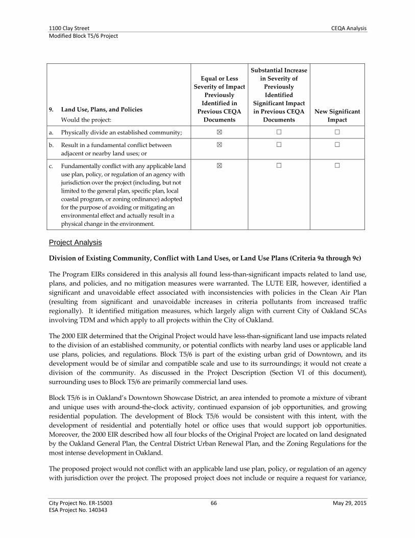
1100 Clay Street CEQA AnalysisModified Block T5/6 Project
City Project No. ER‐15003 66 May 29, 2015 ESA Project No. 140343
9. Land Use, Plans, and Policies
Would the project:
Equal or Less
Severity of Impact
Previously
Identified in
Previous CEQA
Documents
Substantial Increase
in Severity of
Previously
Identified
Significant Impact
in Previous CEQA
Documents
New Significant
Impact
a. Physically divide an established community; ☒ ☐ ☐
b. Result in a fundamental conflict between
adjacent or nearby land uses; or
☒ ☐ ☐
c. Fundamentally conflict with any applicable land
use plan, policy, or regulation of an agency with
jurisdiction over the project (including, but not
limited to the general plan, specific plan, local
coastal program, or zoning ordinance) adopted
for the purpose of avoiding or mitigating an
environmental effect and actually result in a
physical change in the environment.
☒ ☐ ☐
Project Analysis
Division of Existing Community, Conflict with Land Uses, or Land Use Plans (Criteria 9a through 9c)
The Program EIRs considered in this analysis all found less‐than‐significant impacts related to land use,
plans, and policies, and no mitigation measures were warranted. The LUTE EIR, however, identified a
significant and unavoidable effect associated with inconsistencies with policies in the Clean Air Plan
(resulting from significant and unavoidable increases in criteria pollutants from increased traffic
regionally). It identified mitigation measures, which largely align with current City of Oakland SCAs
involving TDM and which apply to all projects within the City of Oakland.
The 2000 EIR determined that the Original Project would have less‐than‐significant land use impacts related
to the division of an established community, or potential conflicts with nearby land uses or applicable land
use plans, policies, and regulations. Block T5/6 is part of the existing urban grid of Downtown, and its
development would be of similar and compatible scale and use to its surroundings; it would not create a
division of the community. As discussed in the Project Description (Section VI of this document),
surrounding uses to Block T5/6 are primarily commercial land uses.
Block T5/6 is in Oakland’s Downtown Showcase District, an area intended to promote a mixture of vibrant
and unique uses with around‐the‐clock activity, continued expansion of job opportunities, and growing
residential population. The development of Block T5/6 would be consistent with this intent, with the
development of residential and potentially hotel or office uses that would support job opportunities.
Moreover, the 2000 EIR described how all four blocks of the Original Project are located on land designated
by the Oakland General Plan, the Central District Urban Renewal Plan, and the Zoning Regulations for the
most intense development in Oakland.
The proposed project would not conflict with an applicable land use plan, policy, or regulation of an agency
with jurisdiction over the project. The proposed project does not include or require a request for variance,
1100 Clay Street CEQA AnalysisModified Block T5/6 Project
City Project No. ER‐15003 67 May 29, 2015 ESA Project No. 140343
the approval of which would potentially affect the environment. Development of the most intensive
scenario of the Modified Block T5/6 Project for purposes of assessing floor area ratio (FAR) would be the
Site A, residential + Site B Option 3, office, which would total approximately 442,413 square feet of gross
floor area on the 1.25‐acre site, or 8.1 FAR.19 A maximum 20.0 FAR is allowed on Block T5/6, pursuant to the
CBD‐C Zoning and CBD General Plan designations.
Conclusion
Based on an examination of the analysis, findings, and conclusions of the 2000 EIR and Program EIRs,
implementation of the proposed project would not substantially increase the severity of significant impacts
identified in the 2000 EIR or those Program EIRs, nor would it result in new significant impacts related to
land use, plans, and policies that were not identified in the 2000 EIR or the other Program EIRs. The 2000
EIR did not identify any mitigation measures related to land use, and no City of Oakland SCAs directly
addressing land use and planning apply to the proposed project.
19 Up to 236,613 square feet on Site A, and up to 205,800 square feet on Site B, on 54,450 square feet (1.25 acres) of the entire lot area.

1100 Clay Street CEQA AnalysisModified Block T5/6 Project
City Project No. ER‐15003 68 May 29, 2015 ESA Project No. 140343
10. Noise
Would the project:
Equal or Less
Severity of Impact
Previously
Identified in
Previous CEQA
Documents
Substantial Increase
in Severity of
Previously
Identified
Significant Impact
in Previous CEQA
Documents New Significant
Impact
a. Generate noise in violation of the City of Oakland Noise Ordinance (Oakland Planning Code Section 17.120.050) regarding construction noise, except if an acoustical analysis is performed that identifies recommend measures to reduce potential impacts. During the hours of 7 p.m. to 7 a.m. on weekdays and 8 p.m. to 9 a.m. on weekends and federal holidays, noise levels received by any land use from construction or demolition shall not exceed the applicable nighttime operational noise level standard;
Generate noise in violation of the City of Oakland nuisance standards (Oakland Municipal Code Section 8.18.020) regarding persistent construction‐related noise;
☒ ☐ ☐
b. Generate noise in violation of the City of Oakland Noise Ordinance (Oakland Planning Code Section 17.120.050) regarding operational noise;
☒ ☐ ☐
c. Generate noise resulting in a 5 dBA permanent increase in ambient noise levels in the project vicinity above levels existing without the project; or, if under a cumulative scenario where the cumulative increase results in a 5 dBA permanent increase in ambient noise levels in the project vicinity without the project (i.e., the cumulative condition including the project compared to the existing conditions) and a 3‐dBA permanent increase is attributable to the project (i.e., the cumulative condition including the project compared to the cumulative baseline condition without the project);
☒ ☐ ☐
d. Expose persons to interior Ldn or CNEL greater than 45 dBA for multi‐family dwellings, hotels, motels, dormitories and long‐term care facilities (and may be extended by local legislative action to include single‐family dwellings) per California Noise Insulation Standards (CCR Part 2, Title 24);
Expose the project to community noise in conflict with the land use compatibility guidelines of the Oakland General Plan after incorporation of all applicable Standard Conditions of Approval (see Figure 1);
Expose persons to or generate noise levels in
☒ ☐ ☐

1100 Clay Street CEQA AnalysisModified Block T5/6 Project
City Project No. ER‐15003 69 May 29, 2015 ESA Project No. 140343
10. Noise
Would the project:
Equal or Less
Severity of Impact
Previously
Identified in
Previous CEQA
Documents
Substantial Increase
in Severity of
Previously
Identified
Significant Impact
in Previous CEQA
Documents New Significant
Impact
excess of applicable standards established by a regulatory agency (e.g., occupational noise standards of the Occupational Safety and Health Administration [OSHA]); or
e. During either project construction or project operation expose persons to or generate groundborne vibration that exceeds the criteria established by the Federal Transit Administration (FTA).
☒ ☐ ☐
Project Analysis
Construction and Operational Noise and Vibration, Exposure of Receptors to Noise (Criteria 10a, 10b,
10d, and 10e)
The Program EIRs considered in this analysis all found less‐than‐significant impacts related to
operational noise, primarily from roadway traffic, as well as noise compatibility. The LUTE EIR identified
mitigation measures to address potential noise conflicts between different land uses.20 Regarding
construction noise, most of the Program EIRs found less‐than‐significant impacts, primarily with
adherence to City of Oakland SCAs; the LUTE EIR identified a significant construction noise and
vibration impact in Downtown, even after the incorporation of mitigation measures. The impact
regarding construction noise and vibration in the LUTE EIR was significant and unavoidable.
Construction Noise
The 2000 EIR determined that noise impacts related to construction of the Original Project would be
significant but that mitigation measures, which are now City of Oakland SCAs, would reduce the severity
of the construction noise impacts to a less than significant level. Construction activities for the Modified
T5/6 Project are expected to occur over approximately 24 months (each Phase), and would entail excavation
and shoring; foundation and below‐grade construction; and construction of the building and finishing
interiors. Implementation of applicable City of Oakland SCAs would minimize construction noise impacts
by limiting hours of construction activities; require best available noise control technology; and notification
of any local residents of construction activities, and to track and respond to noise complaints. As a result,
the construction noise impacts of the Modified T5/6 Project would less than significant, as identified for the
Original Project in the 2000 EIR.
20 The 2011 Redevelopment Plan EIR also identified significant and avoidable noise effects specifically associated with the potential
development of a new baseball stadium at Victory Court, and multimodal safety at at‐grade rail crossings, both near the Oakland
Estuary. These effects would not pertain to the Modified Block T5/6 Project given the distance and presumably minimal
contribution of multimodal trips affecting these impacts.

1100 Clay Street CEQA AnalysisModified Block T5/6 Project
City Project No. ER‐15003 70 May 29, 2015 ESA Project No. 140343
Operational Noise
The 2000 EIR disclosed that during operations of the Original Project buildings, mechanical equipment
would generate noise; however, equipment would be standardized and would be required to comply
with the City of Oakland Noise Ordinance. The measures discussed in the 2000 EIR are now incorporated
in City of Oakland SCAs that would reduce operational noise impacts to less than significant through
project designs that would achieve acceptable interior noise levels for buildings; limit groundborne
vibration at the proposed project site; and require mechanical equipment compliance with applicable
noise performance standards. The proposed project would involve the same types of standardized
mechanical equipment, as well as an emergency generator for each building, which were not previously
considered in the 2000 EIR analysis. Development of the proposed project would incorporate all
applicable SCAs to ensure the less than significant impact identified in the 2000 EIR.
Traffic Noise (Criterion 10c)
The 2000 EIR determined that development of the Original Project would increase noise levels adjacent to
nearby roads due to additional vehicles traveling on nearby streets. The analysis found that the increase in
traffic noise from the Existing Plus Original Project scenario, as compared to existing conditions, would
increase peak hour noise levels by less than 5 A‐weighted decibels (dBA) at all studied roadway segments.
However, the increase in traffic noise between Existing (2000) and the Cumulative Plus Original Project
(2005) scenarios was identified as significant along Castro Street and 18th Street. The 2000 EIR noted that
cumulative increases in traffic noise on these roadways may not be perceptible due to the noise contribution
from traffic on the adjacent I‐980 freeway. The EIR conservatively determined that no feasible mitigation
measures were available, and that the impact would be significant and unavoidable.
The Modified T5/6 Project would not be located on Castro Street or 18th Street (which are three and six
blocks away, respectively), and therefore would not be anticipated to experience significant impacts related
to traffic noise. However, given that 15 years have transpired between the 2000 EIR analysis and this
analysis for the Modified T5/6 Project, a revised quantitative traffic noise analysis has been prepared for
roadways used to access the project site: Broadway, Brush Street, 11th Street and 12th Street.
Additional vehicles traveling throughout the local roadway network as a result of the proposed project
would increase noise levels adjacent to nearby roads. Noise levels were determined for this analysis using
the Federal Highway Administration (FHWA) Traffic Noise Prediction Model and the turning movements
in the traffic section (see 13. Traffic and Circulation) for Existing (2013), Existing Plus Modified T5/6 Project,
and Cumulative (2035) conditions.
Peak hour intersection turning data from the proposed project traffic study were analyzed to evaluate traffic
volume increases and resulting traffic‐generated noise increases on roadway links most affected by
proposed project‐related traffic. The roadway segments analyzed and the results of the noise increases
determined by modeling are shown in Table NOI‐1, below.

1100 Clay Street CEQA AnalysisModified Block T5/6 Project
City Project No. ER‐15003 71 May 29, 2015 ESA Project No. 140343
TABLE NOI-1 PEAK-HOUR TRAFFIC NOISE LEVELS IN THE VICINITY OF THE PROJECT
Roadway Segmenta,b (A)
Existing
(B) Existing
Plus Project
(B-A) Difference between
Existing Plus Project and
Existingc
(C) Cumulative No Project
(2035)
(D) Cumulative Plus Project
(2035)
(D-A) Difference between
Cumulative Plus Project and
Existing
(D-C) Difference between
Cumulative Plus Project and
Cumulative No
Projectd
Broadway north of 12th Street 67.2 67.3 0.1 67.8 67.7 0.5 -0.1
Broadway south of 11th Street 67.4 67.7 0.3 67.1 67.4 0.0 0.3
12th Street west of Broadway 63.2 64.7 1.5 64.7 65.9 2.7 1.2
11th Street west of Broadway 63.4 64.4 0.1 64.9 65.6 2.2 0.7
Brush Street south of 12th Street 66.1 66.3 0.2 67.6 67.7 1.6 0.1 a Road center to receptor distance is 15 meters (approximately 50 feet) for all roadway segments. Noise levels were determined using the Federal
Highway Administration (FHWA) Traffic Noise Prediction Model. b The analysis considered the vehicle mix based on – cars 95 percent, medium trucks three percent, and heavy trucks two percent for Broadway.
Traffic speeds for all vehicle classes were set at 30 mph. c Considered significant if the incremental increase in noise from traffic is greater than the existing ambient noise level by 5.0 dBA Leq, per City of
Oakland, CEQA Thresholds/Criteria of Significance Guidelines. d Considered a cumulatively considerable contribution to a significant noise increase if the incremental increase in noise is greater than 3 dBA. SOURCE: ESA, 2015.
As shown in Table NOI‐1, the increase in traffic noise from the Existing Plus T5/6 Project scenario compared
to the Existing scenario would increase peak hour noise levels by less than 5.0 dBA at all roadway segments.
The roadway segment of 12th Street west of Broadway would experience the greatest increase in traffic
noise, which would be 1.5 dBA above existing ambient noise levels. However, as the noise increase would
not exceed 5.0 dBA, the noise impact on this roadway segment is not considered to be significant. Overall,
traffic noise impacts associated with the proposed project at all analyzed roadway segments in the project
vicinity would be less than significant at the project‐level.
Cumulative Noise
Table NOI‐1 shows that the increase in traffic from between the Cumulative Plus T5/6 Project (2035)
scenario and Existing (2013) would increase peak hour noise levels by less than 5.0 dBA at all roadway
segments. Thus, the cumulative roadway noise impact would be less than significant.
The City also now also considers cumulative noise from all sources: mobile and stationary. As described
above, the proposed project would generate noise from HVAC mechanical equipment. HVAC equipment
would operate within the restrictions of the City’s Noise Ordinance. Chapter 17.120.050 of the City of
Oakland Planning Code specifies the maximum sound level received at residential, public open spaces and
commercial land uses. This equipment would be located over 500 feet from the nearest sensitive receptor
(Domain apartments north of Jefferson Street and 13th Street) at which distance this equipment would not
meaningfully contribute to cumulative noise levels.

1100 Clay Street CEQA AnalysisModified Block T5/6 Project
City Project No. ER‐15003 72 May 29, 2015 ESA Project No. 140343
Conclusion
Based on an examination of the analysis, findings, and conclusions of the 2000 EIR and the Program EIRs,
implementation of the proposed project would not substantially increase the severity of significant
impacts identified in the 2000 EIR or the other Program EIRs, nor would it result in new significant
impacts related to noise that were not identified in the 2000 EIR or in the other Program EIRs. In fact, the
significant Impact D.4 regarding cumulative operational noise and for which no feasible mitigation
measure was available, no longer results. Mitigation Measures D.1a through D.1d identified in the 2000
EIR to address construction noise impacts are now implemented as City of Oakland SCAs, and restated
as such in Attachment A to this document. The proposed project would be required to implement the
City of Oakland SCAs to reduce construction noise, as well as SCAs to achieve interior noise standards,
and require mechanical equipment to meet applicable noise performance standards. All of the applicable
City of Oakland SCAs are identified in Attachment A to this document. For reference, these are SCA
NOI‐1 through SCA NOI‐4 (previously Mitigation Measures D.1a through D.1d, respectively), and SCA
NOI‐5 and SCA NOI‐6.

1100 Clay Street CEQA AnalysisModified Block T5/6 Project
City Project No. ER‐15003 73 May 29, 2015 ESA Project No. 140343
11. Population and Housing
Would the project:
Equal or Less
Severity of Impact
Previously
Identified in
Previous CEQA
Documents
Substantial Increase
in Severity of
Previously
Identified
Significant Impact
in Previous CEQA
Documents
New Significant
Impact
a. Induce substantial population growth in a
manner not contemplated in the General Plan,
either directly (for example, by proposing new
homes and businesses) or indirectly (for
example, through extensions of roads or other
infrastructure), such that additional
infrastructure is required but the impacts of
such were not previously considered or
analyzed;
☒ ☐ ☐
b. Displace substantial numbers of existing
housing, necessitating the construction of
replacement housing elsewhere in excess of that
contained in the City’s Housing Element; or
Displace substantial numbers of people,
necessitating the construction of replacement
housing elsewhere in excess of that contained
in the City’s Housing Element.
☒ ☐ ☐
Project Analysis
Population Growth and Displacement of Housing and People (Criteria 11a and 11b)
The Program EIRs considered in this analysis all found less‐than‐significant impacts related to population
and housing; the LUTE EIR and Redevelopment Plan EIR also addressed employment. The impact
identified in the LUTE EIR addressed unanticipated employment growth (compared to regional ABAG
projections) which would create an increased demand for new housing. The effect was reduced to less
than significant with identified mitigation measures. No other mitigation measures were warranted.
The 2000 EIR determined that impacts related to population growth and displacement of housing and
people with the Original Project would be less than significant. Development of the Modified T5/6 Project
would add up to 262 residential units and 498 residents in on Site A (Phase 1) to the Downtown area.
Assuming the Site B Option 2 which would develop a second residential building on Site B (Phase 2), a
total of 524 units and 996 residents would result with the buildout of Block T5/6. At buildout of the
proposed project, this would represent approximately 0.1 and 2.5 percent of the total 2015‐2035
population growth projected for Oakland and the Downtown/Jack London Square PDA, respectively21;;
these proportions of growth would not be considered substantial.
21 The Downtown / Jack London Square PDA growth from 2010 to 2040: 39,440. City of Oakland growth from 2010 to 2040: 857,240.
(ABAG, 2012)

1100 Clay Street CEQA AnalysisModified Block T5/6 Project
City Project No. ER‐15003 74 May 29, 2015 ESA Project No. 140343
Moreover, infill growth from development of Block T5/6, whether new residents or employees, was
anticipated in the City’s 2015‐2023 Housing Element Update (2014), the Central District Urban Renewal
Plan Amendment (2011), the Oakland General Plan Land Use and Transportation Element (LUTE) (1998,
as amended), and each of the CEQA documents to each of these policy documents. The proposed project
aligns with Oakland General Plan policies that support additional housing opportunities in proximity to
employment centers and alternative transportation options, like Downtown. The proposed project would
not displace any housing units, as none exist on Block T5/6. The proposed project’s impacts to population
and housing would be less than significant, as identified in the 2000 EIR.
Conclusion
Based on an examination of the analysis, findings, and conclusions of the 2000 EIR and the Program EIRs,
implementation of the proposed project would not substantially increase the severity of significant
impacts identified in the 2000 EIR and the other Program EIRs, nor would it result in new significant
impacts related to population and housing that were not identified in the 2000P EIR and those Program
EIRs. The 2000 EIR did not identify any mitigation measures related to population and housing, and none
would be required for the proposed project. Also no SCAs would apply.

1100 Clay Street CEQA AnalysisModified Block T5/6 Project
City Project No. ER‐15003 75 May 29, 2015 ESA Project No. 140343
12. Public Services, Parks and Recreation Facilities
Would the project:
Equal or Less
Severity of Impact
Previously
Identified in
Previous CEQA
Documents
Substantial Increase
in Severity of
Previously
Identified
Significant Impact
in Previous CEQA
Documents
New Significant
Impact
a. Result in substantial adverse physical impacts
associated with the provision of new or
physically altered governmental facilities, or
the need for new or physically altered
governmental facilities, the construction of
which could cause significant environmental
impacts, in order to maintain acceptable
service ratios, response times, or other
performance objectives for any of the
following public services:
Fire protection;
Police protection;
Schools; or
Other public facilities.
☒ ☐ ☐
b. Increase the use of existing neighborhood or
regional parks or other recreational facilities
such that substantial physical deterioration of
the facility would occur or be accelerated; or
Include recreational facilities or require the
construction or expansion of recreational
facilities which might have a substantial
adverse physical effect on the environment.
☒ ☐ ☐
Project Analysis
Public Services and Parks and Recreation (Criteria 12a and 12b)
The Program EIRs considered in this analysis all found less‐than‐significant impacts related to public
services and recreational facilities; no mitigation measures were warranted nor City of Oakland SCAs
identified. The LUTE EIR identified a significant effect regarding increased student enrollment,
particularly in Downtown (and the Waterfront), and identified mitigation measures would not reduce the
effect to less than significant. Thus the impact was significant and unavoidable.22
The 2000 EIR determined that the Original Project impacts related to fire and police protection, schools,
and other public facilities would be less than significant. As discussed for the Original Project, although
development would increase density and population in the area, this growth has been anticipated and
factored into Oakland’s General Plan, as previously discussed (see 11. Population and Housing). The
22 The 1998 LUTE EIR addressed effects on solid waste demand and infrastructure facilities for water, sanitary sewer and
stormwater drainage under Public Services. These topics are addressed in this document under 14. Utilities and Service Systems,
consistent with current City approach.

1100 Clay Street CEQA AnalysisModified Block T5/6 Project
City Project No. ER‐15003 76 May 29, 2015 ESA Project No. 140343
development would occur in an urban area already served by public services and recreation facilities, and
recent plan amendments and corresponding CEQA analyses have consistently determined that the
anticipated growth would not impose a burden on existing public services to create a significant impact.
The 2000 EIR discussed that compliance with standard City practices would further ensure the less‐than‐
significant impact. These included City practices and requirements, such as the Oakland Fire Services’
review of proposed project plans, and project applicants’ required contribution amount to school impact
fees to offset any impacts to school facilities from the proposed project.
City of Oakland SCAs now incorporate most of these standard practices and requirements to address
potential public services and park and recreation facilities impacts. The proposed project would comply
with City of Oakland SCAs related to the increased need for fire protection by requiring all projects to
implement safety features, and to comply with all applicable codes and regulations. The Modified T5/6
Project proposes an approximately 0.25‐acre pedestrian plaza and art park as part of Site A (see Figure 10
in Section IV of this document). The plaza/park will be available to the public and include a variety of
spaces and treatments (sitting areas, paved areas natural and planter landscaping, public art, lawn
seating). Neither the development nor use of the plaza is expected to cause a significant impact, and any
effects that could result are thoroughly addressed here and in other sections of this CEQA Checklist, with
appropriate mitigation measures or SCAs identified.
Adherence to the General Plan’s Open Space, Conservation and Recreation Element policies 3.1, 3.3,
and 3.10 would reduce potential impacts to recreational facilities. In addition, any increases in need for
police protection, fire protection, schools, or other public facilities would be mitigated by adherence to
General Plan policies N.12.1, N.12.2, N.12.5, FI‐1, and FI‐2.
The proposed projects would result in a less‐than‐significant public services, parks and recreation impact,
as was identified in the 2000 EIR.
Conclusion
Based on an examination of the analysis, findings, and conclusions of the 2000 EIR and the other Program
EIRs, implementation of the proposed project would not substantially increase the severity of significant
impacts identified in the 2000 EIR or the other Program EIRs, nor would it result in new significant
impacts related to the provision of public services and parks and recreation facilities that were not
identified in the 2000 EIR or the other Program EIRs. The 2000 EIR did not identify any mitigation
measures related to public services, parks and recreation facilities, and none would be required for the
proposed project. The proposed project would be required to implement SCAs related to fire safety and
compliance with building, fire, and public works code requirements, as identified in the Attachment A to
this document. For reference, these are SCA PSV‐1 and SCA PSV‐2.

1100 Clay Street CEQA AnalysisModified Block T5/6 Project
City Project No. ER‐15003 77 May 29, 2015 ESA Project No. 140343
13. Transportation and Circulation
Would the project:
Equal or Less
Severity of Impact
Previously
Identified in
Previous CEQA
Documents
Substantial Increase
in Severity of
Previously
Identified
Significant Impact
in Previous CEQA
Documents
New Significant
Impact
Conflict with an applicable plan, ordinance, or policy establishing measures of effectiveness for the performance of
the circulation system, taking into account all modes of transportation including mass transit and non‐motorized
travel and relevant components of the circulation system, including but not limited to, intersections, streets,
highways and freeways, pedestrian and bicycle paths, and mass transit, specifically:
Traffic Load and Capacity Thresholds
a. At a study, signalized intersection which is
located outside the Downtown area and that
does not provide direct access to Downtown,
the project would cause the motor vehicle level
of service (LOS) to degrade to worse than
LOS D (i.e., LOS E or F) and cause the total
intersection average vehicle delay to increase
by four (4) or more seconds;
☒ ☐ ☐
b. At a study, signalized intersection which is
located within the Downtown area or that
provides direct access to Downtown, the
project would cause the motor vehicle LOS to
degrade to worse than LOS E (i.e., LOS F) and
cause the total intersection average vehicle
delay to increase by four (4) or more seconds;
☒ ☐ ☐
c. At a study, signalized intersection outside the
Downtown area and that does not provide
direct access to Downtown where the motor
vehicle level of service is LOS E, the project
would cause the total intersection average
vehicle delay to increase by four (4) or more
seconds;
☒ ☐ ☐
d. At a study, signalized intersection outside the
Downtown area and that does not provide
direct access to Downtown where the motor
vehicle level of service is LOS E, the project
would cause an increase in the average delay
for any of the critical movements of six (6)
seconds or more;
☒ ☐ ☐
e. At a study, signalized intersection for all areas
where the level of service is LOS F, the project
would cause (a) the overall volume‐to‐capacity
(“V/C”) ratio to increase 0.03 or more or (b) the
critical movement V/C ratio to increase 0.05 or
more;
☒ ☐ ☐

1100 Clay Street CEQA AnalysisModified Block T5/6 Project
City Project No. ER‐15003 78 May 29, 2015 ESA Project No. 140343
13. Transportation and Circulation
Would the project:
Equal or Less
Severity of Impact
Previously
Identified in
Previous CEQA
Documents
Substantial Increase
in Severity of
Previously
Identified
Significant Impact
in Previous CEQA
Documents
New Significant
Impact
f. At a study, unsignalized intersection the
project would add ten (10) or more vehicles to
the critical movement and after project
completion satisfy the California Manual on
Uniform Traffic Control Devices (MUTCD)
peak hour volume traffic signal warrant;
☒ ☐ ☐
g. For a roadway segment of the Congestion
Management Program (CMP) Network, the
project would cause (a) the LOS to degrade from
LOS E or better to LOS F or (b) the V/C ratio to
increase 0.03 or more for a roadway segment that
would operate at LOS F without the project; or
☒ ☐ ☐
h. Cause congestion of regional significance on a
roadway segment on the Metropolitan
Transportation System (MTS) evaluated per
the requirements of the Land Use Analysis
Program of the CMP.
☒ ☐ ☐
This section of the CEQA Checklist summarizes the findings of the transportation analysis completed for
the proposed project.23
Project Analysis
Criteria 13a through 13h
The Program EIRs considered for this analysis identified significant and unavoidable impacts regarding
intersection and/or roadway segment operations. Various mitigation measures and City of Oakland SCAs
are identified (except in the LUTE EIR, which does not identify SCAs). Other transportation/circulation
effects identified in each of the document are reduced to less than significant with adherence to City of
Oakland SCAs or mitigation measure, as follows.
The LUTE EIR identified SU impacts regarding degradation of the level of service (LOS) for several
roadway segments citywide. A mitigation measure was identified for one Downtown intersection to
reduce the intersection operations to less than significant. All other topics were found less than
significant. The LUTE EIR did not identify an impact at the intersection that is adversely impacted to a
significant and unavoidable level by the Modified T5/6 Project.
23 Fehr & Peers, February 13, 2015. Oakland City Center Development (T5/6) – Transportation Impact Analysis.

1100 Clay Street CEQA AnalysisModified Block T5/6 Project
City Project No. ER‐15003 79 May 29, 2015 ESA Project No. 140343
The Housing Element EIR and Redevelopment Plan EIR and Addendum identified significant and
unavoidable effects to roadway segment operations as well as railroad crossing safety, after the
implementation of identified mitigation measures. The Housing Element EIR did not identify an impact at
the intersection that is adversely impacted to a significant and unavoidable level by the Modified T5/6
Project.
2000 EIR and Overview
The 2000 EIR for the Original Project analyzed transportation and circulation conditions in and around the
project area and identified a significant and unavoidable impact that involved the Brush Street/12th Street/I‐
980 Westbound Off‐Ramp intersection under cumulative buildout conditions (2010). Mitigation Measure B.1a
was identified, but would not reduce the impact at this intersection to less than significant. The significant
and unavoidable impact also affected the intersection of 12th and Broadway, for which Mitigation Measure
B.1b was identified in the 2000 EIR and that would not reduce the impact at the 12th and Broadway
intersection to less than significant. The 2000 EIR also identified significant but mitigable impacts regarding
parking, ridership on BART, bicycle parking, and circulation during periods of construction.
Existing Setting
The study of the Modified T5/6 Project evaluates traffic operations at the following eight intersections in the
vicinity of the project site; these are signalized intersections that were identified in the 2000 EIR and/or other
recent environmental documents as operating at or near Level of Service (LOS)24 F, and where the proposed
project would add substantial traffic (generally 50 or more peak hour trips at signalized intersections
operating at LOS E or better, or 25 or more peak hour trips at signalized intersections operating at LOS F per
recent environmental documents in Oakland) to the intersection. See Appendix B to this document for more
detail on the process used to select study intersections for this assessment.
1. Broadway/West Grand Avenue
2. Brush Street/12th Street/I‐980 Westbound Off‐Ramp
3. Broadway/12th Street
4. Broadway/11th Street
5. Broadway/5th Street/I‐880 Southbound On‐Ramp
All study intersections currently operate at (LOS D or better during both weekday AM and PM peak
hours.25
24 The operations of roadway facilities are typically described with the term level of service (LOS), a qualitative description of
traffic flow based on factors such as speed, travel time, delay, and freedom to maneuver. Six levels are defined from LOS A, which reflects free‐flow conditions where there is very little interaction between vehicles, to LOS F, where the vehicle demand exceeds the capacity and high levels of vehicle delay result. LOS E represents “at‐capacity” operations. When traffic volumes exceed the intersection capacity, stop‐and‐go conditions result and a vehicle may wait through multiple signal cycles before passing through the intersection; these operations are designated as LOS F.
25 Appendix B to this document includes detailed Existing Conditions LOS calculation sheets as well as the Traffic data, automobile turning movement, intersection lane configurations, traffic control devices, peak hour traffic volumes, and pedestrian and bicycle counts.

1100 Clay Street CEQA AnalysisModified Block T5/6 Project
City Project No. ER‐15003 80 May 29, 2015 ESA Project No. 140343
The City of Oakland considers LOS E as the threshold of significance for intersections located within
Downtown or that provide direct access to Downtown26, and LOS D for all other intersections. All study
intersections are located within the Downtown where the threshold of significance is LOS E.
Table TRA‐1 summarizes the existing intersection analysis results.
TABLE TRA-1 INTERSECTION LOS SUMMARY – EXISTING CONDITIONS
Intersection Traffic
Control3
Peak Hour
Delay4
(seconds) LOS
1. Broadway/West Grand Avenue1 Signal AM 18.2 B
PM 18.4 B
2. Brush Street/12th Street/I-980 Westbound Off-Ramp 2 Signal AM 37.8 D
PM 21.4 C
3. Broadway/12th Street2 Signal AM 20.4 C
PM 21.6 C
4. Broadway/11th Street2 Signal AM 15.1 B
PM 19.3 B
5. Broadway/5th Street/I-880 Southbound On-Ramp1 Signal AM 28.6 C
PM 39.4 D
1 Based on intersection volume data presented in Broadway Valdez District Specific Plan Draft EIR (September 2013).
2 Based on intersection volume data presented in Lake Merritt Station Area Plan Draft EIR (November 2013)
3 Signal = intersection is controlled by a traffic signal
4 For signalized intersections, average intersection delay and LOS based on the 2000 HCM method is shown.
SOURCE: Fehr & Peers, 2015.
26 Intersections that provide direct access to downtown are generally defined as principal arterials within two miles of Downtown
and minor arterials within one mile of Downtown, provided that the street connects directly to Downtown.

1100 Clay Street CEQA AnalysisModified Block T5/6 Project
City Project No. ER‐15003 81 May 29, 2015 ESA Project No. 140343
Trip Generation
Tables TRA‐2 through TRA‐4 present the vehicular trip generation estimate for the Modified T5/6 Project
assuming each of the three Site B Options (with the residential use on Site A consistent with each), and
compare to the trip generation estimated in the 2000 EIR for Block T5/6 under the Original Project.
TABLE TRA-2OAKLAND CITY CENTER DEVELOPMENT (T5/6)
AUTOMOBILE TRIP GENERATION SUMMARY – OPTION 1 (RESIDENTIAL/HOTEL)
Land Use Units1
ITE Code Daily
AM Peak Hour PM Peak Hour
In Out Total In Out Total
Residential 262 DU 220 2 1,711 26 106 132 105 57 162
Hotel 300 Rooms 310 3 2,451 94 65 159 92 88 180
Subtotal 4,162 120 171 291 197 145 342
Non-Auto Reduction (-43%)4 -1,790 -52 -74 -126 -85 -62 -147
Net New Project Trips 2,372 68 97 165 112 83 195
Original Project (T5/6)5 2,292 311 42 353 90 438 528
Net Difference 80 -243 55 -188 22 -355 -333
1 DU = Dwelling Units.
2 ITE Trip Generation (9th Edition) land use category 220 (Apartment):
Daily: T = 6.06*X + 123.56 AM Peak Hour: T = 0.49*(X) + 3.73 (20% in, 80% out) PM Peak Hour: T = 0.55*(X) + 17.65 (65% in, 35% out)
3 ITE Trip Generation (9th Edition) land use category 310 (Hotel):
Daily: T = 8.17*(X) AM Peak Hour: T = 0.53*(X) (59% in, 41% out) PM Peak Hour: T = 0.60*(X) (51% in, 49% out)
4 Reduction of 43.0% assumed. Based on City of Oakland Transportation Impact Study Guidelines using BATS 2000 data for
development in an urban environment within 0.5 miles of a BART Station. 5 Oakland City Center Project Draft EIR, January 2000.
Source: Fehr & Peers, 2015.
TABLE TRA-3
OAKLAND CITY CENTER DEVELOPMENT (T5/6) AUTOMOBILE TRIP GENERATION SUMMARY – OPTION 2 (RESIDENTIAL/RESIDENTIAL)
Land Use Units1 ITE
Code Daily
AM Peak Hour PM Peak Hour
In Out Total In Out Total
Residential 524 DU 220 2 3,299 52 208 260 199 107 306
Non-Auto Reduction (-43%)3 -1,419 -22 -89 -111 -86 -46 -132
Net New Project Trips 1,880 30 119 149 113 61 174
Original Project (T5/6)4 2,292 311 42 353 90 438 528
Net Difference -412 -281 77 -204 23 -377 -354 1 DU = Dwelling Units,
2 ITE Trip Generation (9th Edition) land use category 220 (Apartment):
Daily: T = 6.06*X + 123.56 AM Peak Hour: T = 0.49*(X) + 3.73 (20% in, 80% out) PM Peak Hour: T = 0.55*(X) + 17.65 (65% in, 35% out)
3 Reduction of 43.0% assumed. Based on City of Oakland Transportation Impact Study Guidelines using BATS 2000 data for
development in an urban environment within 0.5 miles of a BART Station. 4 Oakland City Center Project Draft EIR, January 2000.
SOURCE: Fehr & Peers, 2015.

1100 Clay Street CEQA AnalysisModified Block T5/6 Project
City Project No. ER‐15003 82 May 29, 2015 ESA Project No. 140343
TABLE TRA-4OAKLAND CITY CENTER DEVELOPMENT (T5/6)
AUTOMOBILE TRIP GENERATION SUMMARY – OPTION 3 (RESIDENTIAL/OFFICE)
Land Use Units1
ITE Code Daily
AM Peak Hour PM Peak Hour
In Out Total In Out Total
Residential 262 DU 220 2 1,711 26 106 132 105 57 162
Office 205.8 KSF 710 3 2,272 300 41 341 53 256 309
Subtotal 3,983 326 147 473 158 313 471
Non-Auto Reduction (-43%)4 -1,713 -140 -63 -203 -68 -135 -203
Net New Project Trips 2,270 186 84 270 90 178 268
Original Project (T5/6)5 2,292 311 42 353 90 438 528
Net Difference -22 -125 42 -83 0 -260 -260
1 DU = Dwelling Units, KSF = 1,000 square feet.
2 ITE Trip Generation (9th Edition) land use category 220 (Apartment):
Daily: T = 6.06*X + 123.56 AM Peak Hour: T = 0.49*(X) + 3.73 (20% in, 80% out) PM Peak Hour: T = 0.55*(X) + 17.65 (65% in, 35% out)
3 ITE Trip Generation (9th Edition) land use category 710 (Office Building):
Daily: Ln(T) = 0.76*Ln(X) + 3.68 AM Peak Hour: Ln(T) = 0.80*Ln(X) + 1.57 (88% in, 12% out) PM Peak Hour: T = 1.12*(X) + 78.45 (17% in, 83% out)
4 Reduction of 43.0% assumed. Based on City of Oakland Transportation Impact Study Guidelines using BATS 2000 data for
development in an urban environment within 0.5 miles of a BART Station. 5 Oakland City Center Project Draft EIR, January 2000.
SOURCE: Fehr & Peers, 2015.
As detailed in Tables 2 and 3 in the Project Description (Section IV of this document), both Sites A and B
would include ground level commercial space. The commercial space is not included in the trip
generation estimates because of its small size and the expected type of uses, which would be primarily
local‐serving retail and food‐related uses and would primarily attract residents, workers, and visitors,
who are already in the area, especially during the peak hours.
The Institute of Transportation Engineers (ITE) data on which the trip generation emerges is based on
data collected at mostly single‐use suburban sites where the automobile is often the only travel mode.
However, Block T5/6 is in a mixed‐use urban environment where many trips are walk, bike, or transit
trips. Since the proposed project is within one block of the 12th Street BART Station, this analysis reduces
the ITE based trip generation by 43 percent to account for the non‐automobile trips. This reduction is
consistent with City of Oakland Transportation Impact Study Guidelines and is based on the Bay Area
Travel Survey (BATS) 2000 which shows that the non‐automobile mode share within one‐half mile of a
BART Station in Alameda County is about 43 percent. A 2011 research study shows reducing ITE based
trip generation using BATS data results in a more accurate estimation of trip generation for mixed use
developments than just using ITE based trip generation.27This reduction is somewhat conservative
considering that the 2011 American Community Survey shows that 55 percent of residents and 64 percent
of workers in Downtown Oakland travel to work by non‐automobile modes.
27 Evaluation of the Operation and Accuracy of Five Available Smart Growth Trip Generation Methodologies. Institute of Transportation
Studies, UC Davis, 2011.

1100 Clay Street CEQA AnalysisModified Block T5/6 Project
City Project No. ER‐15003 83 May 29, 2015 ESA Project No. 140343
As shown in Tables TRA‐2 through TRA‐4, above, all three Site B Options, including the constant Site A
residential use, would generate fewer automobile trips than estimated for Block T5/6 under the Original
Project analyzed in the 2000 EIR. Option 3 Office, which would generate about 2,270 daily, 270 AM, and
268 PM peak hour trips, would have a higher trip generation than Option 1 Hotel or Option 2 Residential.
Therefore, the rest of this analysis focuses on Option 3, which is considered the most impactful scenario
of the proposed project for most environmental factors, as previously discussed under 2. Air Quality.
Table TRA‐5 presents the estimates of proposed project trip generation for all travel modes for Option 3,
which has the highest trip generation.
TABLE TRA-5TRIP GENERATION BY TRAVEL MODE – OPTION 3
Mode
Mode Share Adjustment
Factors1 Daily AM Peak Hour PM Peak Hour
Automobile 57.0% 2,270 270 268
Transit 30.4% 1211 144 143
Bike 3.9% 155 18 18
Walk 23.0% 916 109 108
Total Trips 4,552 541 537
1 Based on City of Oakland Transportation Impact Study Guidelines assuming project site is in an
urban environment within 0.5 miles of a BART Station.
SOURCES: Fehr & Peers, 2015.
Trip Distribution and Assignment, and Study Intersections
The trip distribution and assignment process to estimate how the vehicle trips generated by the project
site would distribute across the roadway network was conducted, and the trip distribution assumptions
was generally based on that documented in the 2000 EIR. The distribution/assignment process also
factored in existing and/or future (2035) conditions according to the recently published CEQA documents
in the Downtown area to determine the level of LOS at intersections along the primary corridors that
would be used by the project traffic from Block T5/6.28 The detailed trip distribution and assignment
information and exhibits are included in Appendix B to this document.
The proposed project would eliminate the existing exit‐only driveway for City Center Garage on Clay
Street. Based on data collected in January 2015, the driveway is currently used by about five vehicles
during the weekday AM peak hour and 106 vehicles during the weekday PM peak hour. This analysis
factors in the diversion of the traffic that currently uses the City Center Garage Driveway on Clay Street
once the driveway is eliminated with the proposed project. This analysis also conservatively assumes that
all diverted City Center Garage traffic would use the existing 11th Street driveway, travel east on 11th
Street and use northbound Broadway and westbound 12th Street to travel to the freeway on‐ramps;
although it is likely that a large portion of the diverted traffic would use either the City Center East
28 Broadway Valdez District Specific Plan Draft EIR (September 2013); Lake Merritt Station Area Plan Draft EIR (November 2013); Jack London Square Redevelopment Project Addendum (May 2014); and 19th and Broadway Mixed Use Project CEQA Exemption (to be published)

1100 Clay Street CEQA AnalysisModified Block T5/6 Project
City Project No. ER‐15003 84 May 29, 2015 ESA Project No. 140343
Garage driveway on 14th Street or use the 11th Street driveway and use southbound Broadway and
westbound 10th Street.
This analysis assesses the potential impacts of the proposed project at the following intersections that the
previously mentioned CEQA documents identify as operating at LOS F and the proposed project would
substantially increase the traffic volume (The estimated peak hour trips added by the proposed project
are shown in parenthesis):
1. Broadway/West Grand Avenue (13 AM and 14 PM peak hour trips added)
2. Brush Street/12th Street/I‐980 Westbound Off‐Ramp (77 AM and 37 PM peak hour trips added)
3. Broadway/12th Street (83 AM and 192 PM peak hour trips added)
4. Broadway/11th Street (90 AM and 288 PM peak hour trips added)
5. Broadway/5th Street/I‐880 Southbound On‐Ramp (15 AM and 32 PM peak hour trips added)
The CEQA documents mentioned above did not analyze all intersections along the corridors that would
be most used by proposed project‐generated traffic. Based on Fehr & Peers’ observations in Downtown
Oakland and as shown above in Table TRA‐1, these intersections currently operate at acceptable
conditions and are expected to continue operating at acceptable conditions in the future. Therefore, the
proposed project is unlikely to cause a significant impact at these locations and their analysis is not
necessary.
Traffic Load and Capacity Analysis
The analysis conducted for the proposed project complies with City of Oakland’s Transportation Impact
Study Guidelines and consider four analysis scenarios: Existing29, Existing Plus Project, 2035 No Project,
and 2035 Plus Project.
This section discusses the impacts of the proposed project on traffic operations under Existing and 2035
conditions based on the City of Oakland’s Thresholds of Significance (see Checklist above and Appendix
B to this document).
Existing Plus Project Intersection Analysis
Table TRA‐6 summarizes the intersection operations results for the Existing No Project and Existing Plus
Project conditions. All study intersections would continue to operate at an acceptable LOS. The proposed
project would not cause a significant impact at the study intersections under Existing Plus Project
conditions (see Appendix B for traffic volume figures for this condition).
2035 Intersection Analysis
Traffic Forecasts
Year 2035 traffic forecasts for all study intersections are from the environmental documents previously
discussed. These forecasts are based on the version of Alameda County Transportation Commission
29 Represents existing conditions based on data obtained from recently published Broadway Valdez District Specific Plan Draft EIR
(September 2013) and Lake Merritt Station Area Plan Draft EIR (November 2013).
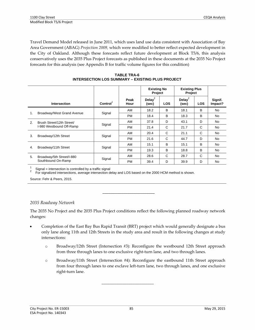
1100 Clay Street CEQA AnalysisModified Block T5/6 Project
City Project No. ER‐15003 85 May 29, 2015 ESA Project No. 140343
Travel Demand Model released in June 2011, which uses land use data consistent with Association of Bay
Area Government (ABAG) Projection 2009, which were modified to better reflect expected development in
the City of Oakland. Although these forecasts reflect future development at Block T5/6, this analysis
conservatively uses the 2035 Plus Project forecasts as published in these documents at the 2035 No Project
forecasts for this analysis (see Appendix B for traffic volume figures for this condition)
TABLE TRA-6 INTERSECTION LOS SUMMARY – EXISTING PLUS PROJECT
Intersection Control1
Peak Hour
Existing No Project
Existing Plus Project
Signif. Impact?
Delay2
(sec) LOS Delay
2
(sec) LOS
1. Broadway/West Grand Avenue Signal AM 18.2 B 18.1 B No
PM 18.4 B 18.3 B No
2. Brush Street/12th Street/ I-980 Westbound Off-Ramp
Signal AM 37.8 D 43.1 D No
PM 21.4 C 21.7 C No
3. Broadway/12th Street Signal AM 20.4 C 21.1 C No
PM 21.6 C 44.7 D No
4. Broadway/11th Street Signal AM 15.1 B 15.1 B No
PM 19.3 B 18.8 B No
5. Broadway/5th Street/I-880 Southbound On-Ramp
Signal AM 28.6 C 28.7 C No
PM 39.4 D 39.9 D No
1 Signal = intersection is controlled by a traffic signal
2 For signalized intersections, average intersection delay and LOS based on the 2000 HCM method is shown.
Source: Fehr & Peers, 2015.
_________________________
2035 Roadway Network
The 2035 No Project and the 2035 Plus Project conditions reflect the following planned roadway network
changes:
Completion of the East Bay Bus Rapid Transit (BRT) project which would generally designate a bus
only lane along 11th and 12th Streets in the study area and result in the following changes at study
intersections:
o Broadway/12th Street (Intersection #3): Reconfigure the westbound 12th Street approach
from three through lanes to one exclusive right‐turn lane, and two through lanes.
o Broadway/11th Street (Intersection #4): Reconfigure the eastbound 11th Street approach
from four through lanes to one exclave left‐turn lane, two through lanes, and one exclusive
right‐turn lane.
_________________________

1100 Clay Street CEQA AnalysisModified Block T5/6 Project
City Project No. ER‐15003 86 May 29, 2015 ESA Project No. 140343
2035 Intersection Operations
Table TRA‐7 summarizes intersection LOS calculations for 2035 No Project and 2035 Plus Project
conditions. The following intersections would operate at LOS F regardless of the proposed project during
both AM and PM peak hours:
Broadway/West Grand Avenue (Intersection #1) during the PM peak hour
Brush Street/12th Street/ I‐980 Westbound Off‐Ramp (Intersection #2) during the AM peak hour
Broadway/5th Street/I‐880 Southbound On‐Ramp (Intersection #5) during the PM peak hour
TABLE TRA-7 INTERSECTION LOS SUMMARY – 2035 CONDITIONS
Intersection Control1
Peak Hour
2035 No Project 2035 Plus Project
Signif. Impact?
Delay2
(sec) LOS3
Delay2
(sec) LOS3
1. Broadway/West Grand Avenue Signal AM 38.7 D 38.7 D No
PM >120
(v/c=1.88) F
>120 (v/c=1.90)
F No
2. Brush Street/12th Street/ I-980 Westbound Off-Ramp
Signal AM
91.2 (v/c=1.02)
F 102.1
(v/c=1.05) F Yes4
PM 40.4 D 44.1 D No
3. Broadway/12th Street Signal AM 25.7 C 29.3 C No
PM 26.0 C 51.7 D No
4. Broadway/11th Street Signal AM 26.3 C 25.9 C No
PM 20.3 C 21.0 C No
5. Broadway/5th Street/ I-880 Southbound On-Ramp
Signal AM 29.0 C 29.0 C No
PM 117.9
(v/c=1.36) F
120.1 (v/c=1.37)
F No
1 Signal = intersection is controlled by a traffic signal
2 For signalized intersections, average intersection delay, LOS, and volume-to-capacity ratio (v/c) for intersections operating at
LOS F based on the 2000 HCM method is shown. 3 Intersections operating at unacceptable levels are shown in bold.
4 The proposed project would cause an impact at this intersection because it would increase the overall intersection v/c ratio by
0.03 or more and a critical movement v/c ratio by 0.05 or more at an intersection already operating at LOS F.
SOURCE: Fehr & Peers, 2015.
Although these study intersections would operate at LOS F, the proposed project would not cause a
significant impact at two of these intersections because it would not trigger any of the significant
thresholds (as described in Appendix B and above in this Checklist).
The proposed project would cause a significant impact at the Brush Street/12th Street/I‐980 Westbound
Off‐Ramp intersection during the AM peak hour. This impact is consistent with Impact B.1a identified in
the 2000 EIR for the Brush Street/12th Street/I‐980 Westbound Off‐Ramp intersection, shown below as
amended to specifically incorporate the Modified T5/6 Project:
Impact TRA‐B.1: The project would result in increases in traffic delay in the downtown. In particular,
the project would result in a deteriorated level of service at the intersection of 12th and Brush Streets in
the weekday a.m. peak hours. This would be a significant impact.

1100 Clay Street CEQA AnalysisModified Block T5/6 Project
City Project No. ER‐15003 87 May 29, 2015 ESA Project No. 140343
Traffic generated by the Modified T5/6 Project would increase the total intersection v/c ratio by 0.03 or
more and increase the v/c ratio for a critical movement by 0.05 or more (Significant Threshold #5) at an
intersection operating at LOS F regardless of the project during the weekday AM peak hour at the Brush
Street/12th Street/I‐980 Westbound Off‐Ramp intersection (Intersection #2) under 2035 conditions.
As identified in the 2000 EIR, no feasible mitigation measures are available that would mitigate the
Modified T5/6 Project impacts at 12th and Brush Streets, specifically the Brush Street/12th Street/I‐980
Westbound Off‐Ramp intersection. Traffic operations at the intersection can be improved by providing
additional automobile travel lanes, such as a third lane on the I‐980 Westbound Off‐Ramp. However,
these modifications cannot be accommodated within the existing automobile right‐of‐way and would
require additional right‐of‐way, and is considered to be infeasible. Furthermore, the intersection is under
the jurisdiction of Caltrans and City of Oakland, as lead agency, does not have jurisdiction at this
intersection, and the mitigation would need to be approved and implemented by Caltrans. The 2000 EIR
mitigation measure is shown below, amended to specify the Modified T5/6 Project:
Mitigation Measure TRA‐B.1a: At 12th and Brush Streets, the Block T12 project sponsor, along
with the developer of Block T5/6 (Shorenstein or its successor) shall work with Caltrans and
coordinate with the City to consider various improvement options, which could include signal
timing improvements or additional lanes on the ramp.No feasible mitigation measures are
available that would mitigate the Project impacts at the Brush Street/12th Street intersection.
Significance after Mitigation: Significant and Unavoidable.
The 2000 EIR proposed signal timing improvements and/or additional lanes on the off‐ramp as potential
mitigation measures at this intersection. The 2000 EIR identified the impact as significant and
unavoidable because the proposed mitigations may not be feasible, intersection is under jurisdiction of
Caltrans, and if the mitigation were feasible, it may not mitigate the impact and potentially cause
secondary impacts. The mitigation measures proposed in the 2000 EIR are currently considered infeasible
for the following reasons:
City of Oakland no longer considers optimizing signal timing parameters as mitigation measure
because they are assumed to occur as part of the City’s routine maintenance of signal systems.
Increasing the signal cycle length at the intersection may increase the queue length on the off‐ramp,
further extending the queues on the mainline freeway and causing safety issues.
Providing additional travel lanes on the off‐ramp or other intersection approaches cannot be
accommodated within the current automobile right‐of‐way and would require additional
automobile right‐of‐way which may require acquisition of additional right‐of‐way, eliminating
pedestrian facilities, and/or reconstructing the freeway overcrossing, which can be costly.
If addition of travel lanes were feasible, they would not be desirable because they may result in
longer pedestrian crossings at the intersection, degrade pedestrian and bicycle safety by exposing
crossing pedestrians and cyclists to additional automobile lanes, and be in conflict with the City’s
Public Transit and Alternative Modes Policy and Complete Streets Policy which state a strong
preference for encouraging the use of non‐automobile transportation modes.
Furthermore, the intersection continues to be under the jurisdiction of Caltrans and City of Oakland, as
lead agency, does not have jurisdiction at this intersection, and the mitigation measure would need to be

1100 Clay Street CEQA AnalysisModified Block T5/6 Project
City Project No. ER‐15003 88 May 29, 2015 ESA Project No. 140343
approved and implemented by Caltrans. Therefore, no feasible mitigation measures are available at this
intersection and the impact would remain significant and unavoidable. This finding is consistent with
that identified in the 2000 EIR, which also identified a significant and unavoidable impact at the Brush
Street/12th Street/I‐980 Westbound Off‐Ramp intersection. The impact is considered equal to or less
severe than that previously identified in the 2000 EIR for the Original Project. Mitigating Measure TRA‐
B.1a is not considered feasible and is no longer needed as explained above.
The 2000 EIR also identified Mitigation Measure TRA‐B.1b at the Broadway/12th Street intersection and
consisted of adjusting signal timings and providing a protected left‐turn phase for the northbound
Broadway approach. The 2000 EIR identified this as a significant and unavoidable impact. The provision
for protected left‐turn phase for the northbound Broadway approach has already been implemented. As
previously presented, the Modified T5/6 Project would not cause an impact at this intersection. Therefore,
Mitigation Measure B.1b is no longer applicable.
Site Plan Review
This section evaluates access, circulation, and safety for all travel modes for Site A, as depicted in Figure 5
in the Project Description (Section IV of this document). No detailed site plan for Site B is currently
available and therefore not included in this assessment.
Automobile Access and Safety
All motorized access to and from the project site would be through the existing left‐in/left‐out City Center
Garage Driveway on 11th Street. The proposed project would eliminate the existing exit‐only driveway
for City Center Garage on Clay Street. Based on data collected in January 2015, the driveway is currently
used by about five vehicles during the weekday AM peak hour and 106 vehicles during the weekday PM
peak hour. The Site A building may provide up to three levels of below‐grade parking for building
residents only. Auto access for the Site A garage would be just south of the City Center Garage Driveway
gates. Based on the current site plan, the Site A building driveway would provide adequate sight distance
between vehicles exiting the Site A garage and vehicles entering and exiting the City Center Garage.
However, the existing center‐median at the City Center Garage entrance may interfere with the travel
path for vehicles entering the Site A Garage.
Recommendation TRA‐1: While not required to address a CEQA impact, the following should be
considered as part of the final design for the project if Site A building would provide on‐site
parking:
a) Ensure that the project driveway would provide adequate sight distance between motorists
exiting the driveway and vehicles entering and exiting the City Center Garage.
b) Ensure that the travel path for vehicles entering the Site A garage would not interfere with
the existing center aisle at the City Center Garage entrance. If necessary, modify the
existing center aisle at the City Center Garage entrance.
_________________________
The Site A building would also provide a loading area in the southeast corner of the building with access
on the City Center Garage Driveway just north of 11th Street. Trucks would access the loading area by
turning into the City Center Garage Driveway, and backing into the loading area. Considering the

1100 Clay Street CEQA AnalysisModified Block T5/6 Project
City Project No. ER‐15003 89 May 29, 2015 ESA Project No. 140343
proximity of the loading area to 11th Street, there may not be adequate sight distance between trucks
backing into the loading area and vehicles turning from 11th Street onto the City Center Garage
Driveway. The loading area would primarily be used by resident move‐ins and move‐out, and is not
expected to be frequently used after the initial move‐in period when building is completed.
Recommendation TRA‐2: While not required to address a CEQA impact, one or more of the
following should be considered as part of the final design for the project:
a) Explore moving the project loading area further from 11th Street to reduce potential
conflicts between trucks backing into the loading space and other vehicles entering and
exiting the driveway on 11th Street.
b) Alternatively to “a”, consider eliminating the loading area and designate on‐street parking
spaces on either 11th and/or12th Streets adjacent to the building as a loading zone for part
or all of the day to serve the commercial component of the project, and/or designate an area
within the project parking garage for residents. Eliminating the loading area would require
the project sponsor’s request for, and City approval of, a variance under the Oakland
Planning Code.
c) If the loading area is maintained at the currently proposed location, provide flaggers when
trucks are backing into the loading dock to minimize potential conflicts between trucks and
other vehicles and/or restrict its use during peak commute periods (7:00 to 9:00 AM and
4:00 to 6:00 PM).
In addition, the proposed project would eliminate the existing right‐out only City Center Garage
Driveway on Clay Street. The driveway is currently used by motorists who mostly turn left on 12th Street
to travel to the I‐980 On‐Ramps. As previously described, the elimination of this driveway would result
in circuitous and longer travel routes; however, it would not significantly affect traffic operations at
intersections in the project vicinity.
_________________________
Pedestrian Access and Safety
Primary pedestrian access to the residential component of the project would be through a main lobby
mid‐block on Clay Street. A secondary access would also be provided on 11th Street. The commercial
components of the proposed project would be in the northwest and southwest corners of the building
with access from both adjacent streets. Although the main lobby is located mid‐block, the project is not
expected to generate many mid‐block pedestrian crossings due to the specific uses and location of
primary pedestrian access points across Clay Street. It is expected that majority of pedestrians would use
the signals on Clay Street at 11th and 12th Streets to cross Clay Street.
The proposed Site A building would provide set‐backs along the three building frontages and widen the
sidewalks adjacent to the building, which would enhance the pedestrian experience. Currently, the two
intersections adjacent to the Site A building on Clay Street at 11th and 12th Streets provide only one curb
ramp per corner.
Recommendation TRA‐3: While not required to address a CEQA impact, the following should be
considered as part of the final design for the project:
1100 Clay Street CEQA AnalysisModified Block T5/6 Project
City Project No. ER‐15003 90 May 29, 2015 ESA Project No. 140343
Explore the feasibility of installing directional curb ramps at the southeast corner of the
Clay Street/12th Street intersection and northeast corner of the Clay Street/11th Street
intersection. Considering that fire hydrants and signal poles are provided at both locations,
construction of curb extensions (bulbouts) may also be required.
The proposed project would increase automobile traffic using the existing garage driveway on 11th Street
and increase pedestrian crossings on the 11th Street sidewalk at the driveway.
Recommendation TRA‐4: While not required to address a CEQA impact, the following should be
considered as part of the final design for the project:
Modify the sidewalk on the north side of 11th Street crossing the existing driveway so that
the through passage zone on the sidewalk is level and at the same grade as the adjacent
sidewalk. Additionally, consider using different paving material, texture, and/or paint for
the segment of sidewalk crossing the driveway to alert both motorists and pedestrians.
_________________________
Transit Access
Transit service providers in the project vicinity include Bay Area Rapid Transit (BART) and AC Transit. The
nearest BART station to the project site is the 12th Street BART Station, about one block east. AC Transit
operates multiple major bus routes in the vicinity of the project, on 11th Street, 12th Street, and Clay Street.
Additional buses, including the Oakland Free Broadway shuttle (“Free B”), operate along Broadway with
the nearest stops near 11th and 12th Streets, about 650 feet east of the Site A building. The proposed project
would not modify access between the project site and bus stops in the vicinity of the project; nor would it
modify access between the project site and the BART Station. This would be a less than significant impact,
and not new or more severe that transit‐related impacts identified in the 2000 EIR.
Recommendation TRANS‐5: While not required to address a CEQA impact, the following should
be considered as part of the final design for the project:
Explore the feasibility of widening the sidewalk on south side of 11th Street east of Clay
Street at the location of the existing bus stop to provide a bus bulb with adequate space to
accommodate a bus shelter and other amenities at the existing bus stop. Constructing the
bus bulb would require elimination of parking and/or a travel lane, which may be feasible
with the proposed reconfiguration of 11th Street at Broadway to accommodate BRT.
The 2000 EIR and each of the subsequent EIR addenda identified a potentially significant transit impact
regarding passenger wait times at the 12th Street BART Station exiting fare gates, Impact B.5 (with designator
amended to be consistent with this CEQA Checklist) is shown below.
Impact TRA‐B.5: Project ridership on AC Transit could be accommodated. Project ridership on BART
could be accommodated on the trains, but is likely to exceed the capacity of the 12th Street station at
project buildout.
1100 Clay Street CEQA AnalysisModified Block T5/6 Project
City Project No. ER‐15003 91 May 29, 2015 ESA Project No. 140343
Mitigation Measure B.5 was identified to address the potential transit impact (BART). Mitigation Measure
B.5 identified the need for further observation and study of exit fare gates at the 11th Street exit of the
12th Street BART Station during the AM peak period to ensure that the maximum passenger wait would
not exceed two minutes through the fare gates. The mitigation measure also required the addition of one
or more new fare gates at the 11th Street exit to the station. The mitigation measure continues to be
applicable. Considering that Site A would be a residential development and would not generate
substantial inbound BART trips during the AM peak period, it would not have a noticeable effect on
passenger wait times at the exit fare gate. Therefore, the study required by this mitigation measure
should be completed prior to development of Site B based on the specific land use option developed at
Site B. Mitigation Measure B.5 is modified as follows:
Mitigation Measure TRA‐B.5: The project sponsor of Block T5/6 (Shorenstein or its successor), if the
Block T5/6 building includes office space, shall conduct a study at each phase of project buildout
subsequent to Building T12prior to the development of Site B, subject to the review and approval of
the City Traffic EngineeringTransportation Services Division, to determine whether there is
adequate exiting capacity at the 12th Street station. The Block T5/6 developer shall work with BART
to assure that with buildout of the project (all four sitesSite A and Site B), adequate exit fare gates
are available at the 11th Street exits in the a.m. peak hour so that the maximum passenger wait does
not exceed two minutes to be processed through the fare gates. This may require the addition of
one or more new fare gates at the 11th Street exit to the station.
Implementation of amended Mitigation Measure TRA‐B.5 would continue to reduce the potential
impact to less than significant impact,
_________________________
Consistency with Adopted Policies, Plans or Programs Supporting Alternative Transportation
The proposed project is consistent with several policies, plans and programs, and would not cause a
significant impact by conflicting with adopted policies, plans, or programs supporting public transit,
bicycles, or pedestrians. The City of Oakland General Plan LUTE, as well as the City’s Public Transit and
Alternative Mode and Complete Streets policies, state a strong preference for encouraging the use of non‐
automobile transportation modes, such as transit, bicycling, and walking. The proposed project would
encourage the use of non‐automobile transportation modes by providing residential and commercial uses
in a dense walkable urban environment that is well‐served by local and regional transit.
The proposed project is consistent with both the City’s Pedestrian Master Plan (PMP) and Bicycle Master
Plan by not making major modifications to existing pedestrian or bicycle facilities in the surrounding
areas and would not adversely affect installation of future facilities. Further, the proposed project would
adhere to City of Oakland SCAs that would require the preparation and implementation of a TDM Plan
because the proposed project would generate more than 50 peak hour trips (see SCA 25 in Attachment A
to this document).
Recommendation TRA‐6: Consistent with the City of Oakland’s requirements, consider including
the following strategies as part of the required TDM program for the proposed project:
a) Implement Recommendations TRA‐3 through TRA‐5 to improve pedestrian and bus rider
environment in the project vicinity.

1100 Clay Street CEQA AnalysisModified Block T5/6 Project
City Project No. ER‐15003 92 May 29, 2015 ESA Project No. 140343
b) Unbundle the cost of parking from the cost of housing where residents pay separately for
their parking spaces.
c) Designate dedicated on‐site parking spaces for car‐sharing.
d) Provide long‐term and short‐term bicycle parking beyond the minimum required by City
of Oakland Planning Code.
e) Cooperate with City of Oakland and/or other regional agencies to allow installation of a
potential bike share station along the project frontage.
f) Designate a TDM coordinator for the project.
g) Provide all new residents and employees with information on the various transportation
options available.
h) Provide residents and/or employees with free or partially subsidized transit passes, which
may include providing Clipper Cards with pre‐loaded value, enrolling in AC Transit
EasyPass program, etc.
Overall, the proposed project would not conflict with adopted City policies, plans, or programs regarding
public transit, bicycle, or pedestrian facilities. This is a less than significant impact; no mitigation
measures are required.
Parking Considerations
Although parking does not relate to environmental impacts required for evaluation under CEQA, this
section summarizes parking supply and demand for automobiles and bicycles; greater detail is provided
in Appendix B to this document. Parking was addressed in the 2000 EIR as the City included it as a
CEQA significance criterion at that time.
Parking Supply and Demand
As described in the Project Description (in Section IV of this document), the Site A building would either
utilize up to 200 parking spaces in the City Center West Garage through a license agreement, or provide
between 150 and 180 parking spaces onsite in up to three below‐grade levels in a combination of standard
spaces and lift parking (as depicted in Figures 7 through 9 in the Project Description).
Table TRA‐8 summarizes the parking supply and demand for the proposed project and shows that the
supply would exceed the demand, resulting in a surplus of 20 to 70 spaces.30 Similar to trip generation
(see Table TRA‐2), the commercial component of the project would generate very little parking demand.
Residential visitors are expected to be accommodated on‐street or within the City Center West Garage.
30 Based on the site plan dated March 6, 2015, the Site A building would provide 250 residential units, which is smaller than the
262 units used in the traffic impact analysis. The parking analysis is based on 262 residential units to be consistent with the rest of the analysis presented in this section.
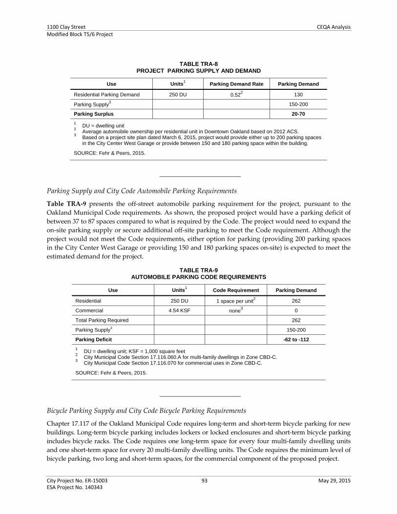
1100 Clay Street CEQA AnalysisModified Block T5/6 Project
City Project No. ER‐15003 93 May 29, 2015 ESA Project No. 140343
TABLE TRA-8PROJECT PARKING SUPPLY AND DEMAND
Use Units1 Parking Demand Rate Parking Demand
Residential Parking Demand 250 DU 0.522 130
Parking Supply3 150-200
Parking Surplus 20-70
1 DU = dwelling unit
2 Average automobile ownership per residential unit in Downtown Oakland based on 2012 ACS.
3 Based on a project site plan dated March 6, 2015, project would provide either up to 200 parking spaces
in the City Center West Garage or provide between 150 and 180 parking space within the building.
SOURCE: Fehr & Peers, 2015.
_________________________
Parking Supply and City Code Automobile Parking Requirements
Table TRA‐9 presents the off‐street automobile parking requirement for the project, pursuant to the
Oakland Municipal Code requirements. As shown, the proposed project would have a parking deficit of
between 37 to 87 spaces compared to what is required by the Code. The project would need to expand the
on‐site parking supply or secure additional off‐site parking to meet the Code requirement. Although the
project would not meet the Code requirements, either option for parking (providing 200 parking spaces
in the City Center West Garage or providing 150 and 180 parking spaces on‐site) is expected to meet the
estimated demand for the project.
TABLE TRA-9AUTOMOBILE PARKING CODE REQUIREMENTS
Use Units1 Code Requirement Parking Demand
Residential 250 DU 1 space per unit2 262
Commercial 4.54 KSF none3 0
Total Parking Required 262
Parking Supply3 150-200
Parking Deficit -62 to -112
1 DU = dwelling unit; KSF = 1,000 square feet
2 City Municipal Code Section 17.116.060.A for multi-family dwellings in Zone CBD-C.
3 City Municipal Code Section 17.116.070 for commercial uses in Zone CBD-C.
SOURCE: Fehr & Peers, 2015.
_________________________
Bicycle Parking Supply and City Code Bicycle Parking Requirements
Chapter 17.117 of the Oakland Municipal Code requires long‐term and short‐term bicycle parking for new
buildings. Long‐term bicycle parking includes lockers or locked enclosures and short‐term bicycle parking
includes bicycle racks. The Code requires one long‐term space for every four multi‐family dwelling units
and one short‐term space for every 20 multi‐family dwelling units. The Code requires the minimum level of
bicycle parking, two long and short‐term spaces, for the commercial component of the proposed project.

1100 Clay Street CEQA AnalysisModified Block T5/6 Project
City Project No. ER‐15003 94 May 29, 2015 ESA Project No. 140343
Table TRA‐10 presents the City’s bicycle parking requirement and the supply for Site A building. As
shown, the proposed project would meet the short‐term and long‐term spaces required. As shown on the
proposed project site plan (Figure 5), long‐term bicycle parking for 64 bicycles would have the ground
level, adjacent to the residential building lobby, with direct access from both Clay and 11th Streets;31 16
short‐term bicycle parking spaces would be provided along the sidewalks, which may require easement if
within the public right‐of‐way.
TABLE TRA-10BICYCLE PARKING REQUIREMENTS
Land Use Size1
Long-Term Short-Term
Spaces per Unit Spaces
Spaces per Unit Spaces
Residential 250 DU 1:4 DU 66 1:20 DU 13
Commercial 4.52 KSF Min. 2 Min. 2
Total Required Bicycle Spaces 68 15
Total Bicycle Parking Provided 64 16
Bicycle Parking Surplus 03 +1
1 DU = dwelling unit; KSF = 1,000 square feet
2 Based on Oakland Municipal Code Sections 17.117.090 and 17.117.110
3 The current site plan identifies 64 long-term bicycle spaces. The long-term bicycle parking facility would
accommodate 68 or more bicycles. Therefore, this analysis does not identify a deficit.
Source: Fehr & Peers, 2015.
The 2000 EIR and each of the subsequent EIR addenda identified Mitigation Measure B.4 to address a
parking deficit impact; Mitigation Measure B.4 identified various measures such as construction of
additional parking and implementing various TDM strategies, to mitigate to a less than significant level
the significant impact on parking. Although parking is no longer considered for evaluation under CEQA,
the parking assessment presented above shows that although Building A would not meet City code
requirements for parking, it would provide adequate parking supply to meet the estimated parking
demand. Recommendation TRA‐6 (TDM Plan) is consistent with Mitigation Measure B.4 in the 2000 EIR.
Therefore, other components of Mitigation Measure B.4 are no longer applicable.
The 2000 EIR and each of the subsequent EIR addenda identified Mitigation Measure B.6 to address a
potential bicycle parking deficit impact. As discussed above, these requirements are now required by City
Code and therefore the mitigation measure is no longer required. Also, Recommendation TRA‐6 (TDM
Plan) above includes as a strategy that the proposed project should provide more than the minimum
bicycle parking required by City of Oakland Planning Code.
_________________________
Loading Requirements
In accordance with City Municipal Code Section 17.116.140, the Site A is required to provide two loading
spaces for the residential component and no loading spaces for the non‐residential component of the
31 The Project site plan identifies 64 long‐term bicycle parking spaces. However, it is expected that the long‐term bicycle parking
facility would accommodate bicycle parking for 68 or more bicycles. Therefore, this analysis does not identify a deficit.in long‐
term bicycle parking.

1100 Clay Street CEQA AnalysisModified Block T5/6 Project
City Project No. ER‐15003 95 May 29, 2015 ESA Project No. 140343
project. The building would provide two loading spaces that can be accessed from the existing City
Center driveway on 11th Street. Thus, the building would satisfy the City’s loading requirements.
However, if the loading spaces are eliminated per Recommendation TRA‐2, the building would not
satisfy the City’s loading requirement and would require a variance.
_________________________
Conclusion
The proposed project would not result in significant impacts to the project study intersections, either
under the existing plus proposed project conditions or Year 2035 plus proposed project conditions.
Based on an examination of the analysis, findings, and conclusions of the 2000 EIR and the other Program
EIRs, implementation of the Modified T5/6 Project would not substantially increase the severity of
significant impacts identified in the 2000 EIR or the other Program EIRs, nor would it result in new
significant impacts related to transportation and circulation that were not identified in the 2000 EIR or the
other Program EIR, as summarized below.
The Modified T5/6 Project would result in the significant and unavoidable impact involving the Brush
Street/12th Street/I‐980 Westbound Off‐Ramp intersection under 2035 with Project conditions. The 2000
EIR previously identified a significant impact at this same intersection under cumulative buildout
conditions (2010), and identified Mitigation Measure B.1a, now amended in this CEQA Checklist as
Mitigation Measure TRA‐B.1a, which would not reduce the impact to less than significant and that
continues to apply to the project; the impact remains significant and unavoidable.
The 2000 EIR also identified Mitigation Measure B.1b to address a significant unavoidable impact at the
intersection of 12th and Broadway, however, the proposed project avoids a significant impact at that
location; Mitigation Measure B.1b would not apply to the proposed project. Mitigation Measures TRA‐
B.1a (title modified from the 2000 EIR) and TRA‐B.5 would continue to apply to the project and are listed
in Attachment A to this document.
The impact of the proposed project is considered equal to or less severe than that previously identified in
the 2000 EIR for the Original Project or in the Program EIRs. The proposed project would not result in any
other transportation related significant impacts.
The proposed project would implement recommended improvement measures identified in the
transportation analysis completed for the proposed project and address automobile access and safety,
directional curb ramps for pedestrians, and additional TDM strategies.
In addition, the proposed project will adhere to SCAs related to City review and approval of all
improvements proposed in the public right‐of‐way, reduction of vehicle traffic and parking demand
generated by development projects, and construction traffic and parking management, as identified in
Appendix A, at the end of the CEQA Checklist. For reference, these are SCA TRA‐1 (previously
Mitigation Measure B.7), SCA AES‐7, SCA AES‐8, SCA AIR‐2 (previously Mitigation Measure C.2a).
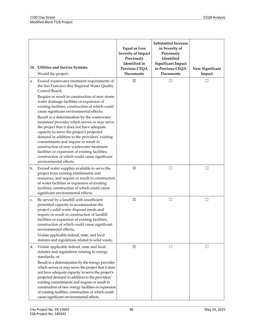
1100 Clay Street CEQA AnalysisModified Block T5/6 Project
City Project No. ER‐15003 96 May 29, 2015 ESA Project No. 140343
14. Utilities and Service Systems
Would the project:
Equal or Less
Severity of Impact
Previously
Identified in
Previous CEQA
Documents
Substantial Increase
in Severity of
Previously
Identified
Significant Impact
in Previous CEQA
Documents
New Significant
Impact
a. Exceed wastewater treatment requirements of
the San Francisco Bay Regional Water Quality
Control Board;
Require or result in construction of new storm
water drainage facilities or expansion of
existing facilities, construction of which could
cause significant environmental effects;
Result in a determination by the wastewater
treatment provider which serves or may serve
the project that it does not have adequate
capacity to serve the projectʹs projected
demand in addition to the providersʹ existing
commitments and require or result in
construction of new wastewater treatment
facilities or expansion of existing facilities,
construction of which could cause significant
environmental effects;
☒ ☐ ☐
b. Exceed water supplies available to serve the
project from existing entitlements and
resources, and require or result in construction
of water facilities or expansion of existing
facilities, construction of which could cause
significant environmental effects;
☒ ☐ ☐
c. Be served by a landfill with insufficient
permitted capacity to accommodate the
project’s solid waste disposal needs and
require or result in construction of landfill
facilities or expansion of existing facilities,
construction of which could cause significant
environmental effects;
Violate applicable federal, state, and local
statutes and regulations related to solid waste;
☒ ☐ ☐
d. Violate applicable federal, state and local
statutes and regulations relating to energy
standards; or
Result in a determination by the energy provider
which serves or may serve the project that it does
not have adequate capacity to serve the projectʹs
projected demand in addition to the providersʹ
existing commitments and require or result in
construction of new energy facilities or expansion
of existing facilities, construction of which could
cause significant environmental effects.
☒ ☐ ☐

1100 Clay Street CEQA AnalysisModified Block T5/6 Project
City Project No. ER‐15003 97 May 29, 2015 ESA Project No. 140343
Project Analysis
Water, Wastewater, and Stormwater (Criteria 14a and 14b)
Most of the Program EIRs considered in this analysis all found less‐than‐significant impacts related to
water, wastewater, or stormwater facilities, finding no mitigation measures warranted but adhering to
certain City of Oakland SCAs. The LUTE EIR identified a significant effect regarding these topics and
identified mitigation measures that reduced the effects to less than significant.32
The water and sanitary sewer demand and stormwater facilities, as well as solid waste and energy
associated with the proposed project, have been addressed in the 2000 EIR for the Original Project, and
the Modified T5/6 Project assessments are supported by the project‐specific engineering and service
demand reports provided by the project sponsor. The Phase 1 project would generate approximately 490
gallons per minute (gpm) of wastewater and a water demand of approximately 572 gpm which translates
into approximately 824,000 gallons per day (gpd). Together, both phases of the project would generate
approximately 980 gpm of wastewater and an estimated water demand of approximately 1,647,360 gpd.
Specifically, the 2000 EIR determined that development of the Original Project would not exceed
wastewater treatment requirements of the applicable Regional Water Quality Control Board; would not
require or result in the construction of new water or wastewater treatment or storm water drainage
facilities or expansion of existing facilities; would not result in a shortfall in water supply or wastewater
treatment capacity. As previously described in this CEQA Checklist (see 11. Population and Housing, and
12. Public Services, Parks and Recreation Facilities), although development would increase density and
population in the area, this growth has been anticipated and factored into Oakland’s General Plan LUTE
(1998, as amended), its 2015‐2023 Housing Element Update (2014), the Central District Urban Renewal
Plan Amendment (2011), and each of the CEQA documents prepared and approved/certified for each of
these policy documents. Therefore, the proposed project has been accounted for in the water demand
projections associated with development of the Original Project. Further, the development would occur in
an urban area already served by public service utilities and infrastructure.
No changes with respect to the environmental issues listed above have occurred. The Modified T5/6
Project would not result in new significant impacts regarding the provision of or need for new or
substantially expanded utilities and service systems, the construction of which could cause significant
environmental effects. Therefore, the proposed projects would not result in any new or more substantial
effect on water and sewer services. The impact would remain less than significant.
The 2000 EIR also determined that development of the Original project would have less‐than‐significant
impacts related to stormwater and wastewater facilities. As previously discussed (see 8. Hydrology and
Water Quality), new development of the proposed project would likely decrease storm drain runoff
through the proposed project’s incorporation of City of Oakland SCAs intended to reduce runoff (and
maintain stormwater quality). Development of the proposed project may increase sewer demand, and
implementation of SCAs requiring stormwater control during and after construction would address
potential impacts on stormwater treatment and sanitary sewer infrastructure. The impact of the proposed
32 The 1998 LUTE EIR addressed effects on solid waste demand and infrastructure facilities for water, sanitary sewer and
stormwater drainage under Public Services. These topics are addressed in this document under 14. Utilities and Service Systems,
consistent with current City approach.

1100 Clay Street CEQA AnalysisModified Block T5/6 Project
City Project No. ER‐15003 98 May 29, 2015 ESA Project No. 140343
project regarding stormwater and sanitary sewer infrastructure would remain less than significant as
identified in the 2000 EIR.
Solid Waste Services (Criterion 14c)
Most of the Program EIRs considered in this analysis all found less‐than‐significant impacts related to
solid waste, adhering to City of Oakland SCAs; no mitigation measures were warranted. The LUTE EIR
identified a significant effect regarding solid waste and identified a mitigation measure that reduced the
effect to less than significant.
As described in the 2000 EIR, impacts associated with solid waste would be less than significant;
development of the Original Project would overburden landfill(s); and would comply with federal, state,
and local statutes related to solid waste. Nonhazardous solid waste from the proposed project site would
be ultimately hauled to the Altamont Landfill and Resource Facility. The Altamont Landfill would have
sufficient capacity to accept waste generated by development with the proposed projects, as determined
in the 2000 EIR. In addition, the proposed projects will comply with a City of Oakland SCA pertaining to
waste reduction and recycling and thereby reduce waste through compliance with the City of Oakland’s
Recycling Space Allocation Ordinance (Oakland Municipal Code, Chapter 17.118). The impact regarding
solid waste services would remain less than significant as identified in the 2000 EIR.
Energy (Criterion 14d)
The Program EIRs considered in this analysis all found less‐than‐significant impacts related to energy;
with adherence to City of Oakland SCAs; no mitigation measures were warranted.
As reported in the 2000 EIR, development of the Original Project would result in less‐than‐significant
impacts related to energy standards and use. The Modified T5/6 Project would result in the same impact
and would comply with the standards of Title 24 of the California Code of Regulations. City of Oakland
SCAs pertaining to compliance with the green building ordinance would require construction projects to
incorporate energy‐conserving design measures. (Also see discussion of Renewable Energy in Attachment
D to this document). The proposed project’s impact regarding solid waste services would remain less
than significant as identified in the 2000 EIR.
Conclusion
Based on an examination of the analysis, findings, and conclusions of the 2000 EIR and the other Program
EIRs, implementation of the proposed project would not substantially increase the severity of significant
impacts identified in the 2000 EIR or other Program EIRs, nor would it result in new significant impacts
related to utilities and service systems that were not identified in the 2000 EIR or the other Program EIRs.
The 2000 EIR did not identify any mitigation measures related to utilities and service systems, and none
would be required for the proposed project. The proposed project would be required to implement SCAs
related to sewer capacity, stormwater drainage facilities, solid waste services, and energy, as identified in
Attachment A to this document. For reference, these are SCA UTIL‐1 through SCA UTIL‐3, and SCA
HYD‐1 and SCA HYD‐2.

1100 Clay Street CEQA AnalysisModified Block T5/6 Project
City Project No. ER‐15003 99 May 29, 2015 ESA Project No. 140343
Attachments A. Standard Conditions of Approval and Mitigation Monitoring and Reporting Program B. Criteria for Use of Addendum, Per CEQA Guidelines Sections 15162, 15164, and 15168 C. Project Consistency with Community Plan or Zoning, Per CEQA Guidelines Section 15183 D. Infill Performance Standards, Per CEQA Guidelines Section 15183.3
Appendices A. Reference Figures from 2000 EIR Aesthetics Analysis B. LOS Sheets

1100 Clay Street CEQA AnalysisModified Block T5/6 Project
City Project No. ER‐15003 99 May 29, 2015 ESA Project No. 140343
ATTACHMENT A: STANDARD CONDITIONS OF APPROVAL AND MITIGATION MONITORING AND REPORTING PROGRAM
This Standard Conditions of Approval and Mitigation Monitoring and Reporting Program (SCAMMRP)
is based on the CEQA Analysis prepared for the Oakland City Center Modified Block T5/6 Project.
This SCAMMRP is in compliance with Section 15097 of the CEQA Guidelines, which requires that the
Lead Agency “adopt a program for monitoring or reporting on the revisions which it has required in the
project and the measures it has imposed to mitigate or avoid significant environmental effects.” The
SCAMMRP lists mitigation measures recommended in the 2000 Oakland City Center EIR, as modified in
the subsequent addenda to the 2000 EIR. The SCAMMRP also lists the City’s Standard Conditions of
Approval (“SCAs”) identified and modified in the subsequent addenda to the 2000 EIR; the SCAs are
measures that would minimize potential adverse effects that could result from implementation of the
project, to ensure the conditions are implemented and monitored. The SCAMMRP also identifies the
mitigation monitoring requirements for each mitigation measure and SCA.
This CEQA Analysis is also based on the analysis in the following Program EIRs that apply to the
Modified T5/6 Project: Oakland’s 1998 General Plan Land Use and Transportation Element (LUTE) EIR,
the 2010 General Plan Housing Element Update EIR and 2014 Addendum, and the 2011 Central District
Urban Renewal Plan Amendments EIR (or “Redevelopment Plan Amendments EIR”). None of the
mitigation measures or SCAs from these Program EIRs are included in this SCAMMRP because they, or
an updated or equally effective mitigation measure or SCA, is identified in the 2000 EIR, its addenda, or
in this CEQA Analysis for the Modified T5/6 Project.
To the extent that there is any inconsistency between any mitigation measures and/or SCAs, the more
restrictive conditions shall govern; to the extent any mitigation measure and/or SCA identified in the
CEQA Analysis were inadvertently omitted, they are automatically incorporated herein by reference.
The first column of the SCAMMRP table identifies the mitigation measure or SCA applicable to
that topic in the CEQA Analysis. While a mitigation measure or SCA can apply to more than one
topic, it is listed in its entirety only under its primary topic (as indicated in the mitigation or SCA
designator). The SCAs are numbered to specifically apply to the Modified T5/6 Project and this
CEQA Analysis; however, the SCAs as presented in the City’s Standard Conditions of Approval and
Uniformly Applied Development Standards document33 are included in parenthesis for cross‐reference
purposes. Substantive modifications or notes on the previously identified mitigation measures or
SCAs are shown in double underline or double strikethrough format.
The second column identifies the monitoring schedule or timing applicable the Project.
The third column names the party responsible for monitoring the required action for the Project.
The project sponsor is responsible for compliance with any recommendations identified in City‐approved
technical reports all applicable mitigation measures adopted, and with all SCAs set forth herein at its sole
cost and expense, unless otherwise expressly provided in a specific mitigation measure or condition of
approval, and subject to the review and approval of the City of Oakland. Overall monitoring and
compliance with the mitigation measures will be the responsibility of the Bureau or Planning, Zoning
33 Dated September 5, 2007, as amended and/or supplemented through August 30, 2013.

1100 Clay Street CEQA AnalysisModified Block T5/6 Project
City Project No. ER‐15003 100 May 29, 2015 ESA Project No. 140343
Inspections Division. Prior to the issuance of a demolition, grading, and/or construction permit, the
project sponsor shall pay the applicable mitigation and monitoring fee to the City in accordance with the
City’s Master Fee Schedule.
Standard Conditions of Approval/Mitigation Measures Mitigation Implementation/ Monitoring
Schedule Responsibility
Aesthetics, Shadow and Wind
Mitigation Measure AES‐F.2: (amended per Addendum #5)
The City shall require the project sponsors Shorenstein Strada T5, LLC or its successor),
as applicable) to incorporate, to the maximum extent feasible, specific design elements
in the final siting and designs for the high rises that would reduce ground‐level winds
within the Downtown Showcase District.
Recommended modifications to the building masses as tested [i.e., 425‐foot towers
tested for the 1997 General Plan Land Use and Transportation Element EIR] to reduce
winds would include some of the design features already included in the project, such
as:
placing the buildings back from the sidewalk, which would likely reduce
winds at the sidewalk itself;
the introduction of curved facades, which could reduce the tendency of the
project structures to intercept upper‐level winds and direct them down to
ground level; and
placing the tower atop a lower podium level, which would serve to interrupt
winds traveling down the tower before they reach ground level.
In addition, the use of facade articulation, to break up winds along the building face,
and horizontally projecting wind screens, to disturb the downward flow of wind, could
further serve to reduce ground‐level winds.
Prior to issuance of a building permit for each phase.
City of Oakland Bureau of Planning and Building
SCA AES‐1 (Standard Condition of Approval 12): Required Landscape Plan for New
Construction and Certain Additions to Residential Facilities (Applies Only to
Phase 1 Site A and Phase 2 Site B Option 2 of the Modified T5/6 Project)
Submittal and approval of a landscape plan for the entire site is required for the
establishment of a new residential unit (excluding secondary units of five hundred
(500) square feet or less), and for additions to Residential Facilities of over five hundred
(500) square feet. The landscape plan and the plant materials installed pursuant to the
approved plan shall conform to all provisions of Chapter 17.124 of the Oakland
Planning Code, including the following:
a) Landscape plan shall include a detailed planting schedule showing the proposed
location, sizes, quantities, and specific common botanical names of plant species.
b) Landscape plans for projects involving grading, rear walls on downslope lots
requiring conformity with the screening requirements in Section 17.124.040, or
vegetation management prescriptions in the S‐11 zone, shall show proposed
landscape treatments for all graded areas, rear wall treatments, and vegetation
management prescriptions.
c) Landscape plan shall incorporate pest‐resistant and drought‐tolerant landscaping
practices. Within the portions of Oakland northeast of the line formed by State
Highway 13 and continued southerly by Interstate 580, south of its intersection
with State Highway 13, all plant materials on submitted landscape plans shall be
fire resistant. The City Bureau of Planning shall maintain lists of plant materials
and landscaping practices considered pest‐resistant, fire‐resistant, and drought‐
tolerant.
d) All landscape plans shall show proposed methods of irrigation. The methods shall
ensure adequate irrigation of all plant materials for at least one growing season.
Prior to issuance of a building permit for each phase involving residential use.
City of Oakland Bureau of Planning and Building
City of Oakland Bureau of Building Services Division, Zoning Inspections
City of Oakland, Public Works, Environmental Services

1100 Clay Street CEQA AnalysisModified Block T5/6 Project
City Project No. ER‐15003 101 May 29, 2015 ESA Project No. 140343
Standard Conditions of Approval/Mitigation Measures Mitigation Implementation/ Monitoring
Schedule Responsibility
SCA AES‐2 (Standard Condition of Approval 13): Landscape Requirements for Street
Frontages (Residential Construction)
a) All areas between a primary Residential Facility and abutting street lines shall be
fully landscaped, plus any unpaved areas of abutting rights‐of‐way of improved
streets or alleys, provided, however, on streets without sidewalks, an unplanted
strip of land five (5) feet in width shall be provided within the right‐of‐way along
the edge of the pavement or face of curb, whichever is applicable. Existing plant
materials may be incorporated into the proposed landscaping if approved by the
Director of the Bureau of Planning.
b) In addition to the general landscaping requirements set forth in Chapter 17.124, a
minimum of one (1) fifteen‐gallon tree, or substantially equivalent landscaping
consistent with city policy and as approved by the Director the Bureau of
Planning, shall be provided for every twenty‐five (25) feet of street frontage. On
streets with sidewalks where the distance from the face of the curb to the outer
edge of the sidewalk is at least six and one‐half (6 ½) feet, the trees to be provided
shall include street trees to the satisfaction of the Director of Parks and Recreation.
Prior to final inspection of the building permit for each phase.
City of Oakland Bureau of Planning and Building
City of Oakland Bureau of Building Services Division, Zoning Inspections
City of Oakland, Public Works, Environmental Services
SCA AES‐3 (Standard Condition of Approval 15): Landscape Maintenance (Residential
Construction)
All required planting shall be permanently maintained in good growing condition and,
whenever necessary, replaced with new plant materials to ensure continued
compliance with applicable landscaping requirements. All required fences, walls and
irrigation systems shall be permanently maintained in good condition and, whenever
necessary, repaired or replaced.
Ongoing. City of Oakland Bureau of Building Services Division, Zoning Inspections
City of Oakland, Public Works, Environmental Services
SCA AES‐4 (Standard Condition of Approval 17): Landscape Requirements for Street
Frontages (Commercial and Manufacturing) (Applies Only to Phase 1 Site A
and Phase 2 Site B Option 2 of the Modified T5/6 Project)
On streets with sidewalks where the distance from the face of the curb to the outer
edge of the sidewalk is at least six and one‐half (6 ½) feet and does not interfere with
access requirements, a minimum of one (1) twenty‐four (24) inch box tree shall be
provided for every twenty‐five (25) feet of street frontage, unless a smaller size is
recommended by the City arborist. The trees to be provided shall include species
acceptable to the Tree Services Division.
Prior to final inspection of the building permit for each phase.
City of Oakland Bureau of Planning and Building
City of Oakland Bureau of Building Services Division, Zoning Inspections
City of Oakland, Public Works, Environmental Services
SCA AES‐5 (Standard Condition of Approval 18): Landscape Maintenance (Commercial
and Manufacturing) (Applies Only to Phase 1 Site A and Phase 2 Site B Option 2 of the Modified T5/6 Project)
All required planting shall be permanently maintained in good growing condition and,
whenever necessary, replaced with new plant materials to ensure continued
compliance with applicable landscaping requirements. All required irrigation systems
shall be permanently maintained in good condition and, whenever necessary, repaired
or replaced.
Ongoing. City of Oakland Bureau of Planning and Building
City of Oakland Bureau of Building Services Division, Zoning Inspections
SCA AES‐6 (Standard Condition of Approval 19): Underground Utilities
Prior to issuance of a building permit, the project applicant for projects under the Specific
Plan shall submit plans for review and approval by the Bureau of Building Services
and the Public Works Agency, and other relevant agencies as appropriate, that show all
new electric and telephone facilities; fire alarm conduits; street light wiring; and other
Prior to issuance of a building permit for each phase.
City of Oakland Bureau of Planning and Building
City of Oakland Bureau of

1100 Clay Street CEQA AnalysisModified Block T5/6 Project
City Project No. ER‐15003 102 May 29, 2015 ESA Project No. 140343
Standard Conditions of Approval/Mitigation Measures Mitigation Implementation/ Monitoring
Schedule Responsibility
wiring, conduits, and similar facilities placed underground. The new facilities shall be
placed underground along the project applicant’s street frontage and from the project
applicant’s structures to the point of service. The plans shall show all electric,
telephone, water service, fire water service, cable, and fire alarm facilities installed in
accordance with standard specifications of the serving utilities.
Building Services Division, Zoning Inspections
City of Oakland, Public Works, Environmental Services
SCA AES‐7 (Standard Condition of Approval 20): Improvements in the Public Right‐of‐
Way (General)
Approved prior to the issuance of a P‐job or building permit
a) The project applicant shall submit Public Improvement Plans to Bureau of
Building Services for adjacent public rights‐of‐way (ROW) showing all proposed
improvements and compliance with the conditions and/or mitigations and City
requirements including but not limited to curbs, gutters, sewer laterals, storm
drains, street trees, paving details, locations of transformers and other above
ground utility structures, the design specifications and locations of facilities
required by the East Bay Municipal Utility District (EBMUD), street lighting, on‐
street parking and accessibility improvements compliant with applicable
standards and any other improvements or requirements for the project as
provided for in this Approval. Encroachment permits shall be obtained as
necessary for any applicable improvements‐ located within the public ROW.
b) Review and confirmation of the street trees by the City’s Tree Services Division is
required as part of this condition and/or mitigations.
c) The Bureau of Planning and the Public Works Agency will review and approve
designs and specifications for the improvements. Improvements shall be
completed prior to the issuance of the final building permit.
d) The Fire Services Division will review and approve fire crew and apparatus
access, water supply availability and distribution to current codes and standards.
Prior to the issuance of a P‐job or building permit for each phase.
City of Oakland Bureau of Planning and Building
City of Oakland Bureau of Building Services Division, Zoning Inspections
City of Oakland, Public Works, Environmental Services
SCA AES‐8 (Standard Condition of Approval 21): Improvements in the Public Right‐of‐
Way (Specific)
Approved prior to the issuance of a grading or building permit. Final building and public
improvement plans submitted to the Bureau of Building Services shall include the
following components:
a) Install additional standard City of Oakland streetlights.
b) Remove and replace any existing driveway that will not be used for access to the
property with new concrete sidewalk, curb and gutter.
c) Reconstruct drainage facility to current City standard.
d) Provide separation between sanitary sewer and water lines to comply with current
City of Oakland and Alameda Health Department standards.
e) Construct wheelchair ramps that comply with Americans with Disabilities Act
requirements and current City Standards.
f) Remove and replace deficient concrete sidewalk, curb and gutter within property
frontage.
g) Provide adequate fire department access and water supply, including, but not limited
to currently adopted fire codes and standards.
Prior to the issuance of a grading or building permit for each phase.
City of Oakland Bureau of Planning and Building
City of Oakland Bureau of Building Services Division, Zoning Inspections
City of Oakland, Public Works, Environmental Services
SCA AES‐9 (Standard Condition of Approval 40): Lighting Plan.
The proposed lighting fixtures shall be adequately shielded to a point below the light
bulb and reflector and that prevent unnecessary glare onto adjacent properties. Plans
shall be submitted to the Bureau of Planning and Building Services, Zoning Division,
and the Electrical Services Division of the Public Works Department for review and
Prior to the issuance of an electrical or building permit for each phase.
City of Oakland Bureau of Planning and Building
City of Oakland Bureau of

1100 Clay Street CEQA AnalysisModified Block T5/6 Project
City Project No. ER‐15003 103 May 29, 2015 ESA Project No. 140343
Standard Conditions of Approval/Mitigation Measures Mitigation Implementation/ Monitoring
Schedule Responsibility
approval. All lighting shall be architecturally integrated into the site. Building Services Division, Zoning Inspections
City of Oakland, Public Works, Electrical Services
Also SCA BIO‐1. See Biological Resources, below.
Air Quality
SCA AIR‐1 (Standard Condition of Approval A): Construction‐Related Air Pollution
Controls, Dust and Equipment Emissions (Previously Mitigation Measure
AIR C.1)
Ongoing throughout demolition, grading, and/or construction.
During construction, the project applicant shall require the construction contractor to
implement all of the following applicable measures recommended by the BAAQMD:
a) Water all exposed surfaces of active construction areas at least twice daily (using
reclaimed water if possible). Watering should be sufficient to prevent airborne dust
from leaving the site. Increased watering frequency may be necessary whenever wind
speeds exceed 15 miles per hour. Reclaimed water should be used whenever possible.
b) Cover all trucks hauling soil, sand, and other loose materials or require all trucks to
maintain at least two feet of freeboard (i.e., the minimum required space between the
top of the load and the top of the trailer).
c) All visible mud or dirt track‐out onto adjacent public roads shall be removed using wet
power vacuum street sweepers at least once per day. The use of dry power sweeping is
prohibited.
d) Pave all roadways, driveways, sidewalks, etc., as soon as feasible. In addition, building
pads should be laid as soon as possible after grading unless seeding or soil binders are
used.
e) Enclose, cover, water twice daily or apply (non‐toxic) soil stabilizers to exposed
stockpiles (dirt, sand, etc.).
f) Limit vehicle speeds on unpaved roads to 15 miles per hour.
g) Idling times on all diesel‐fueled commercial vehicles over 10,000 lbs. shall be
minimized either by shutting equipment off when not in use or reducing the
maximum idling time to five minutes (as required by the California airborne toxics
control measure Title 13, Section 2485, of the California Code of Regulations). Clear
signage to this effect shall be provided for construction workers at all access points.
h) Idling times on all diesel‐fueled off‐road vehicles over 25 horsepower shall be
minimized either by shutting equipment off when not in use or reducing the
maximum idling time to five minutes and fleet operators must develop a written idling
policy (as required by Title 13, Section 2449 of the California Code of Regulations.)
i) All construction equipment shall be maintained and properly tuned in accordance
with the manufacturer’s specifications. All equipment shall be checked by a certified
mechanic and determined to be running in proper condition prior to operation.
j) Post a publicly visible sign that includes the contractor’s name and telephone number
to contact regarding dust complaints. When contacted, the contractor shall respond
and take corrective action within 48 hours. The telephone numbers of contacts at the
City and the BAAQMD shall also be visible. This information may be posted on other
required on‐site signage.
k) Portable equipment shall be powered by electricity if available. If electricity is not
available, propane or natural gas shall be used if feasible. Diesel engines shall only be
Ongoing throughout demolition, grading, and/or construction for each phase.
Prior to starting operations for each phase.
City of Oakland Bureau of Planning and Building
City of Oakland Bureau of Building Services Division, Zoning Inspections
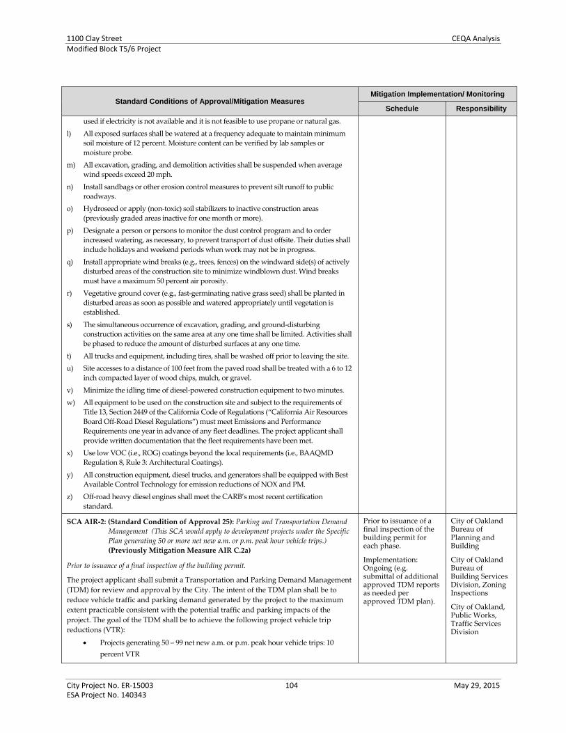
1100 Clay Street CEQA AnalysisModified Block T5/6 Project
City Project No. ER‐15003 104 May 29, 2015 ESA Project No. 140343
Standard Conditions of Approval/Mitigation Measures Mitigation Implementation/ Monitoring
Schedule Responsibility
used if electricity is not available and it is not feasible to use propane or natural gas.
l) All exposed surfaces shall be watered at a frequency adequate to maintain minimum
soil moisture of 12 percent. Moisture content can be verified by lab samples or
moisture probe.
m) All excavation, grading, and demolition activities shall be suspended when average
wind speeds exceed 20 mph.
n) Install sandbags or other erosion control measures to prevent silt runoff to public
roadways.
o) Hydroseed or apply (non‐toxic) soil stabilizers to inactive construction areas
(previously graded areas inactive for one month or more).
p) Designate a person or persons to monitor the dust control program and to order
increased watering, as necessary, to prevent transport of dust offsite. Their duties shall
include holidays and weekend periods when work may not be in progress.
q) Install appropriate wind breaks (e.g., trees, fences) on the windward side(s) of actively
disturbed areas of the construction site to minimize windblown dust. Wind breaks
must have a maximum 50 percent air porosity.
r) Vegetative ground cover (e.g., fast‐germinating native grass seed) shall be planted in
disturbed areas as soon as possible and watered appropriately until vegetation is
established.
s) The simultaneous occurrence of excavation, grading, and ground‐disturbing
construction activities on the same area at any one time shall be limited. Activities shall
be phased to reduce the amount of disturbed surfaces at any one time.
t) All trucks and equipment, including tires, shall be washed off prior to leaving the site.
u) Site accesses to a distance of 100 feet from the paved road shall be treated with a 6 to 12
inch compacted layer of wood chips, mulch, or gravel.
v) Minimize the idling time of diesel‐powered construction equipment to two minutes.
w) All equipment to be used on the construction site and subject to the requirements of
Title 13, Section 2449 of the California Code of Regulations (“California Air Resources
Board Off‐Road Diesel Regulations”) must meet Emissions and Performance
Requirements one year in advance of any fleet deadlines. The project applicant shall
provide written documentation that the fleet requirements have been met.
x) Use low VOC (i.e., ROG) coatings beyond the local requirements (i.e., BAAQMD
Regulation 8, Rule 3: Architectural Coatings).
y) All construction equipment, diesel trucks, and generators shall be equipped with Best
Available Control Technology for emission reductions of NOX and PM.
z) Off‐road heavy diesel engines shall meet the CARB’s most recent certification
standard.
SCA AIR‐2: (Standard Condition of Approval 25): Parking and Transportation Demand
Management (This SCA would apply to development projects under the Specific
Plan generating 50 or more net new a.m. or p.m. peak hour vehicle trips.)
(Previously Mitigation Measure AIR C.2a)
Prior to issuance of a final inspection of the building permit.
The project applicant shall submit a Transportation and Parking Demand Management
(TDM) for review and approval by the City. The intent of the TDM plan shall be to
reduce vehicle traffic and parking demand generated by the project to the maximum
extent practicable consistent with the potential traffic and parking impacts of the
project. The goal of the TDM shall be to achieve the following project vehicle trip
reductions (VTR):
Projects generating 50 – 99 net new a.m. or p.m. peak hour vehicle trips: 10
percent VTR
Prior to issuance of a final inspection of the building permit for each phase.
Implementation: Ongoing (e.g. submittal of additional approved TDM reports as needed per approved TDM plan).
City of Oakland Bureau of Planning and Building
City of Oakland Bureau of Building Services Division, Zoning Inspections
City of Oakland, Public Works, Traffic Services Division

1100 Clay Street CEQA AnalysisModified Block T5/6 Project
City Project No. ER‐15003 105 May 29, 2015 ESA Project No. 140343
Standard Conditions of Approval/Mitigation Measures Mitigation Implementation/ Monitoring
Schedule Responsibility
Projects generating 100 or more net new a.m. or p.m. peak hour vehicle trips: 20
percent VTR
The TDM plan shall include strategies to increase pedestrian, bicycle, transit, and
carpool use, and reduce parking demand. All four modes of travel shall be considered,
as appropriate. VTR strategies to consider include, but are not limited to, the following:
a) Inclusion of additional long term and short term bicycle parking that meets the design
standards set forth in chapter five of the Bicycle Master Plan, and Bicycle Parking
Ordinance (chapter 17.117 of the Oakland Planning Code), and shower and locker
facilities in commercial developments that exceed the requirement.
b) Construction of and/or access to bikeways per the Bicycle Master Plan; construction of
priority Bikeway Projects, on‐site signage and bike lane striping.
c) Installation of safety elements per the Pedestrian Master Plan (such as cross walk
striping, curb ramps, count‐down signals, bulb outs, etc.) to encourage convenient and
safe crossing at arterials, in addition to safety elements required to address safety
impacts of the project.
d) Installation of amenities such as lighting, street trees, trash receptacles per the
Pedestrian Master Plan and any applicable streetscape plan.
e) Construction and development of transit stops/shelters, pedestrian access, way finding
signage, and lighting around transit stops per transit agency plans or negotiated
improvements.
f) Direct on‐site sales of transit passes purchased and sold at a bulk group rate (through
programs such as AC Transit Easy Pass or a similar program through another transit
agency).
g) Provision of a transit subsidy to employees or residents, determined by the project
sponsor and subject to review by the City, if the employees or residents use transit or
commute by other alternative modes.
h) Provision of an ongoing contribution to AC Transit service to the area between the
development and nearest mass transit station prioritized as follows:
i. Contribution to AC Transit bus service;
ii. Contribution to an existing area shuttle or streetcar service; and
iii. Establishment of new shuttle or streetcar service. The amount of contribution
(for any of the above scenarios) would be based upon the cost of establishing
new shuttle service (Scenario 3).
i) Guaranteed ride home program for employees, either through 511.org or through
separate program.
j) Pre‐tax commuter benefits (commuter checks) for employees.
k) Free designated parking spaces for on‐site car‐sharing program (such as City Car
Share, Zip Car, etc.) and/or car‐share membership for employees or tenants.
l) Onsite carpooling and/or vanpooling program that includes preferential (discounted
or free) parking for carpools and vanpools.
m) Distribution of information concerning alternative transportation options. Parking
spaces sold/leased separately for residential units. Charge employees for parking, or
provide a cash incentive or transit pass alternative to a free parking space in
commercial properties.
n) Parking management strategies; including attendant/valet parking and shared parking
spaces.
o) Requiring tenants to provide opportunities and the ability to work off‐site.
p) Allow employees or residents to adjust their work schedule in order to complete the
basic work requirement of five eight‐hour workdays by adjusting their schedule to
reduce vehicle trips to the worksite (e.g., working four, ten‐hour days; allowing
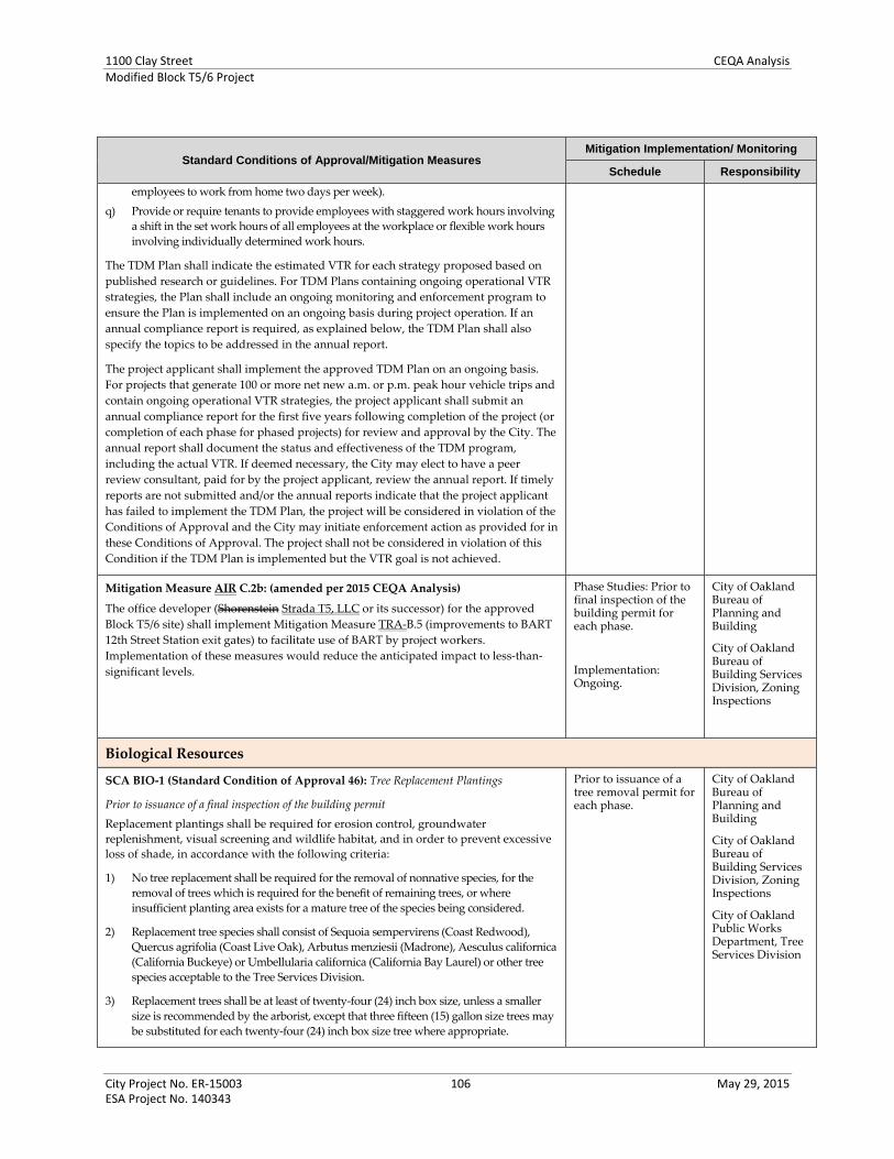
1100 Clay Street CEQA AnalysisModified Block T5/6 Project
City Project No. ER‐15003 106 May 29, 2015 ESA Project No. 140343
Standard Conditions of Approval/Mitigation Measures Mitigation Implementation/ Monitoring
Schedule Responsibility
employees to work from home two days per week).
q) Provide or require tenants to provide employees with staggered work hours involving
a shift in the set work hours of all employees at the workplace or flexible work hours
involving individually determined work hours.
The TDM Plan shall indicate the estimated VTR for each strategy proposed based on
published research or guidelines. For TDM Plans containing ongoing operational VTR
strategies, the Plan shall include an ongoing monitoring and enforcement program to
ensure the Plan is implemented on an ongoing basis during project operation. If an
annual compliance report is required, as explained below, the TDM Plan shall also
specify the topics to be addressed in the annual report.
The project applicant shall implement the approved TDM Plan on an ongoing basis.
For projects that generate 100 or more net new a.m. or p.m. peak hour vehicle trips and
contain ongoing operational VTR strategies, the project applicant shall submit an
annual compliance report for the first five years following completion of the project (or
completion of each phase for phased projects) for review and approval by the City. The
annual report shall document the status and effectiveness of the TDM program,
including the actual VTR. If deemed necessary, the City may elect to have a peer
review consultant, paid for by the project applicant, review the annual report. If timely
reports are not submitted and/or the annual reports indicate that the project applicant
has failed to implement the TDM Plan, the project will be considered in violation of the
Conditions of Approval and the City may initiate enforcement action as provided for in
these Conditions of Approval. The project shall not be considered in violation of this
Condition if the TDM Plan is implemented but the VTR goal is not achieved.
Mitigation Measure AIR C.2b: (amended per 2015 CEQA Analysis)
The office developer (Shorenstein Strada T5, LLC or its successor) for the approved
Block T5/6 site) shall implement Mitigation Measure TRA‐B.5 (improvements to BART
12th Street Station exit gates) to facilitate use of BART by project workers.
Implementation of these measures would reduce the anticipated impact to less‐than‐
significant levels.
Phase Studies: Prior to final inspection of the building permit for each phase.
Implementation: Ongoing.
City of Oakland Bureau of Planning and Building
City of Oakland Bureau of Building Services Division, Zoning Inspections
Biological Resources
SCA BIO‐1 (Standard Condition of Approval 46): Tree Replacement Plantings
Prior to issuance of a final inspection of the building permit
Replacement plantings shall be required for erosion control, groundwater
replenishment, visual screening and wildlife habitat, and in order to prevent excessive
loss of shade, in accordance with the following criteria:
1) No tree replacement shall be required for the removal of nonnative species, for the
removal of trees which is required for the benefit of remaining trees, or where
insufficient planting area exists for a mature tree of the species being considered.
2) Replacement tree species shall consist of Sequoia sempervirens (Coast Redwood),
Quercus agrifolia (Coast Live Oak), Arbutus menziesii (Madrone), Aesculus californica
(California Buckeye) or Umbellularia californica (California Bay Laurel) or other tree
species acceptable to the Tree Services Division.
3) Replacement trees shall be at least of twenty‐four (24) inch box size, unless a smaller
size is recommended by the arborist, except that three fifteen (15) gallon size trees may
be substituted for each twenty‐four (24) inch box size tree where appropriate.
Prior to issuance of a tree removal permit for each phase.
City of Oakland Bureau of Planning and Building
City of Oakland Bureau of Building Services Division, Zoning Inspections
City of Oakland Public Works Department, Tree Services Division

1100 Clay Street CEQA AnalysisModified Block T5/6 Project
City Project No. ER‐15003 107 May 29, 2015 ESA Project No. 140343
Standard Conditions of Approval/Mitigation Measures Mitigation Implementation/ Monitoring
Schedule Responsibility
4) Minimum planting areas must be available on site as follows:
- For Sequoia sempervirens, three hundred fifteen square feet per tree;
- For all other species listed in #2 above, seven hundred (700) square feet per
tree.
5) In the event that replacement trees are required but cannot be planted due to site
constraints, an in lieu fee as determined by the master fee schedule of the City
may be substituted for required replacement plantings, with all such revenues
applied toward tree planting in city parks, streets and medians.
Plantings shall be installed prior to the issuance of a final inspection of the building
permit, subject to seasonal constraints, and shall be maintained by the project applicant
until established. The Tree Reviewer of the Tree Division of the Public Works
Department may require a landscape plan showing the replacement planting and the
method of irrigation. Any replacement planting which fails to become established
within one year of planting shall be replanted at the project applicant’s expense.
SCA BIO‐2 (Standard Condition of Approval 44): Tree Removal During Breeding Season
Prior to issuance of a tree removal permit
To the extent feasible, removal of any tree and/or other vegetation suitable for nesting of
raptors shall not occur during the breeding season of March 15 and August 15. If tree
removal must occur during the breeding season, all sites shall be surveyed by a qualified
biologist to verify the presence or absence of nesting raptors or other birds. Pre‐removal
surveys shall be conducted within 15 days prior to start of work from March 15 through
May 31, and within 30 days prior to the start of work from June 1 through August 15. The
pre‐removal surveys shall be submitted to the Bureau of Planning and the Tree Services
Division of the Public Works Department. If the survey indicates the potential presences
of nesting raptors or other birds, the biologist shall determine an appropriately sized
buffer around the nest in which no work will be allowed until the young have
successfully fledged. The size of the nest buffer will be determined by the biologist in
consultation with the CDFG, and will be based to a large extent on the nesting species and
its sensitivity to disturbance. In general, buffer sizes of 200 feet for raptors and 50 feet for
other birds should suffice to prevent disturbance to birds nesting in the urban
environment, but these buffers may be increased or decreased, as appropriate, depending
on the bird species and the level of disturbance anticipated near the nest.
Prior to issuance of a demolition, grading, or building permit for each phase.
City of Oakland Bureau of Planning and Building
City of Oakland Bureau of Building Services Division, Zoning Inspections
City of Oakland Public Works Department, Tree Services Division
SCA BIO‐3 (Standard Condition of Approval 45): Tree Removal Permit
Prior to issuance of a demolition, grading, or building permit.
Prior to removal of any protected trees, per the Protected Tree Ordinance, located on
the project site or in the public right‐of‐way adjacent to the project, the project
applicant must secure a tree removal permit from the Tree Division of the Public
Works Department, and abide by the conditions of that permit.
Prior to issuance of a demolition, grading, or building permit for each phase.
City of Oakland Bureau of Planning and Building
City of Oakland Bureau of Building Services Division, Zoning Inspections
City of Oakland Public Works Department, Tree Services Division
SCA BIO‐4 (Standard Condition of Approval 47): Tree Protection during Construction
Prior to issuance of a demolition, grading, or building permit
Adequate protection shall be provided during the construction period for any trees
which are to remain standing, including the following, plus any recommendations of
an arborist:
a) Before the start of any clearing, excavation, construction or other work on the site,
Prior to issuance of a demolition, grading, or building permit for each phase.
City of Oakland Bureau of Planning and Building
City of Oakland Bureau of Building Services Division, Zoning
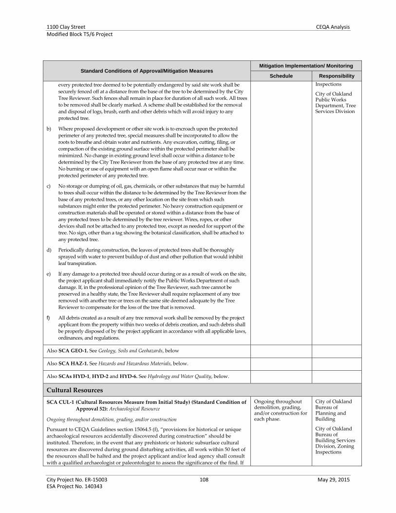
1100 Clay Street CEQA AnalysisModified Block T5/6 Project
City Project No. ER‐15003 108 May 29, 2015 ESA Project No. 140343
Standard Conditions of Approval/Mitigation Measures Mitigation Implementation/ Monitoring
Schedule Responsibility
every protected tree deemed to be potentially endangered by said site work shall be
securely fenced off at a distance from the base of the tree to be determined by the City
Tree Reviewer. Such fences shall remain in place for duration of all such work. All trees
to be removed shall be clearly marked. A scheme shall be established for the removal
and disposal of logs, brush, earth and other debris which will avoid injury to any
protected tree.
b) Where proposed development or other site work is to encroach upon the protected
perimeter of any protected tree, special measures shall be incorporated to allow the
roots to breathe and obtain water and nutrients. Any excavation, cutting, filing, or
compaction of the existing ground surface within the protected perimeter shall be
minimized. No change in existing ground level shall occur within a distance to be
determined by the City Tree Reviewer from the base of any protected tree at any time.
No burning or use of equipment with an open flame shall occur near or within the
protected perimeter of any protected tree.
c) No storage or dumping of oil, gas, chemicals, or other substances that may be harmful
to trees shall occur within the distance to be determined by the Tree Reviewer from the
base of any protected trees, or any other location on the site from which such
substances might enter the protected perimeter. No heavy construction equipment or
construction materials shall be operated or stored within a distance from the base of
any protected trees to be determined by the tree reviewer. Wires, ropes, or other
devices shall not be attached to any protected tree, except as needed for support of the
tree. No sign, other than a tag showing the botanical classification, shall be attached to
any protected tree.
d) Periodically during construction, the leaves of protected trees shall be thoroughly
sprayed with water to prevent buildup of dust and other pollution that would inhibit
leaf transpiration.
e) If any damage to a protected tree should occur during or as a result of work on the site,
the project applicant shall immediately notify the Public Works Department of such
damage. If, in the professional opinion of the Tree Reviewer, such tree cannot be
preserved in a healthy state, the Tree Reviewer shall require replacement of any tree
removed with another tree or trees on the same site deemed adequate by the Tree
Reviewer to compensate for the loss of the tree that is removed.
f) All debris created as a result of any tree removal work shall be removed by the project
applicant from the property within two weeks of debris creation, and such debris shall
be properly disposed of by the project applicant in accordance with all applicable laws,
ordinances, and regulations.
Inspections
City of Oakland Public Works Department, Tree Services Division
Also SCA GEO‐1. See Geology, Soils and Geohazards, below
Also SCA HAZ‐1. See Hazards and Hazardous Materials, below.
Also SCAs HYD‐1, HYD‐2 and HYD‐6. See Hydrology and Water Quality, below.
Cultural Resources
SCA CUL‐1 (Cultural Resources Measure from Initial Study) (Standard Condition of
Approval 52): Archaeological Resource
Ongoing throughout demolition, grading, and/or construction
Pursuant to CEQA Guidelines section 15064.5 (f), “provisions for historical or unique
archaeological resources accidentally discovered during construction” should be
instituted. Therefore, in the event that any prehistoric or historic subsurface cultural
resources are discovered during ground disturbing activities, all work within 50 feet of
the resources shall be halted and the project applicant and/or lead agency shall consult
with a qualified archaeologist or paleontologist to assess the significance of the find. If
Ongoing throughout demolition, grading, and/or construction for each phase.
City of Oakland Bureau of Planning and Building
City of Oakland Bureau of Building Services Division, Zoning Inspections

1100 Clay Street CEQA AnalysisModified Block T5/6 Project
City Project No. ER‐15003 109 May 29, 2015 ESA Project No. 140343
Standard Conditions of Approval/Mitigation Measures Mitigation Implementation/ Monitoring
Schedule Responsibility
any find is determined to be significant, representatives of the project proponent
and/or lead agency and the qualified archaeologist would meet to determine the
appropriate avoidance measures or other appropriate measure, with the ultimate
determination to be made by the City of Oakland. All significant cultural materials
recovered shall be subject to scientific analysis, professional museum curation, and a
report prepared by the qualified archaeologist according to current professional
standards.
In considering any suggested measure proposed by the consulting archaeologist
in order to mitigate impacts to historical resources or unique archaeological
resources, the project applicant shall determine whether avoidance is necessary
and feasible in light of factors such as the nature of the find, project design, costs,
and other considerations. If avoidance is unnecessary or infeasible, other
appropriate measures (e.g., data recovery) shall be instituted. Work may proceed
on other parts of the project site while measure for historical resources or unique
archaeological resources is carried out.
Should an archaeological artifact or feature be discovered on‐site during project
construction, all activities within a 50‐foot radius of the find would be halted until
the findings can be fully investigated by a qualified archaeologist to evaluate the
find and assess the significance of the find according to the CEQA definition of a
historical or unique archaeological resource. If the deposit is determined to be
significant, the project applicant and the qualified archaeologist shall meet to
determine the appropriate avoidance measures or other appropriate measure,
subject to approval by the City of Oakland, which shall assure implementation of
appropriate measures recommended by the archaeologist. Should
archaeologically‐significant materials be recovered, the qualified archaeologist
shall recommend appropriate analysis and treatment, and shall prepare a report
on the findings for submittal to the Northwest Information Center.
Archaeological Resources – Sensitive Areas. Prior to issuance of a demolition,
grading, or building permit, the project applicant shall implement either Provision
A (Intensive Pre‐Construction Study) or Provision D (Construction ALERT Sheet).
However, if in either case a high potential presence of historic‐period
archaeological resources on the project site is indicated, or a potential resource is
discovered, the project applicant shall also implement all of the following
provisions:
- Provision B (Construction‐Period Monitoring),
- Provision C (Avoidance and/or Find Recovery), and
- Provision D (to establish a Construction ALERT Sheet if the Intensive Pre‐
Construction Study was originally implemented per Provision A, or to
update and provide more specificity to the initial Construction ALERT Sheet
if a Construction ALERT Sheet was originally implemented per Provision D).
Provision A through Provision D are detailed as follows:
Provision A: Intensive Pre‐Construction Study – The project applicant, upon approval
from the City Bureau of Planning , may choose to complete a site‐specific, intensive
archaeological resources study prior to soil‐disturbing activities occurring on the
project site. The purpose of the site‐specific, intensive archaeological resources study
is to identify early the potential presence of history‐period archaeological resources
on the project site. If that approach is selected, the study shall be conducted by a
qualified archaeologist approved by the City Bureau of Planning. If prepared, at a
minimum, the study shall include:
- An intensive cultural resources study of the project site, including subsurface
presence/absence studies, of the project site. Field studies conducted by the
approved archaeologist(s) may include, but are not limited to, auguring and
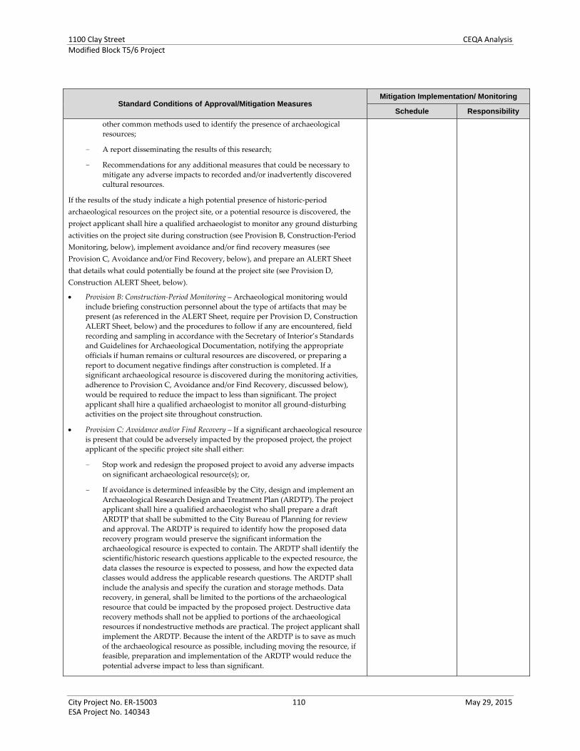
1100 Clay Street CEQA AnalysisModified Block T5/6 Project
City Project No. ER‐15003 110 May 29, 2015 ESA Project No. 140343
Standard Conditions of Approval/Mitigation Measures Mitigation Implementation/ Monitoring
Schedule Responsibility
other common methods used to identify the presence of archaeological
resources;
- A report disseminating the results of this research;
- Recommendations for any additional measures that could be necessary to
mitigate any adverse impacts to recorded and/or inadvertently discovered
cultural resources.
If the results of the study indicate a high potential presence of historic‐period
archaeological resources on the project site, or a potential resource is discovered, the
project applicant shall hire a qualified archaeologist to monitor any ground disturbing
activities on the project site during construction (see Provision B, Construction‐Period
Monitoring, below), implement avoidance and/or find recovery measures (see
Provision C, Avoidance and/or Find Recovery, below), and prepare an ALERT Sheet
that details what could potentially be found at the project site (see Provision D,
Construction ALERT Sheet, below).
Provision B: Construction‐Period Monitoring – Archaeological monitoring would
include briefing construction personnel about the type of artifacts that may be
present (as referenced in the ALERT Sheet, require per Provision D, Construction
ALERT Sheet, below) and the procedures to follow if any are encountered, field
recording and sampling in accordance with the Secretary of Interior’s Standards
and Guidelines for Archaeological Documentation, notifying the appropriate
officials if human remains or cultural resources are discovered, or preparing a
report to document negative findings after construction is completed. If a
significant archaeological resource is discovered during the monitoring activities,
adherence to Provision C, Avoidance and/or Find Recovery, discussed below),
would be required to reduce the impact to less than significant. The project
applicant shall hire a qualified archaeologist to monitor all ground‐disturbing
activities on the project site throughout construction.
Provision C: Avoidance and/or Find Recovery – If a significant archaeological resource
is present that could be adversely impacted by the proposed project, the project
applicant of the specific project site shall either:
- Stop work and redesign the proposed project to avoid any adverse impacts
on significant archaeological resource(s); or,
- If avoidance is determined infeasible by the City, design and implement an
Archaeological Research Design and Treatment Plan (ARDTP). The project
applicant shall hire a qualified archaeologist who shall prepare a draft
ARDTP that shall be submitted to the City Bureau of Planning for review
and approval. The ARDTP is required to identify how the proposed data
recovery program would preserve the significant information the
archaeological resource is expected to contain. The ARDTP shall identify the
scientific/historic research questions applicable to the expected resource, the
data classes the resource is expected to possess, and how the expected data
classes would address the applicable research questions. The ARDTP shall
include the analysis and specify the curation and storage methods. Data
recovery, in general, shall be limited to the portions of the archaeological
resource that could be impacted by the proposed project. Destructive data
recovery methods shall not be applied to portions of the archaeological
resources if nondestructive methods are practical. The project applicant shall
implement the ARDTP. Because the intent of the ARDTP is to save as much
of the archaeological resource as possible, including moving the resource, if
feasible, preparation and implementation of the ARDTP would reduce the
potential adverse impact to less than significant.

1100 Clay Street CEQA AnalysisModified Block T5/6 Project
City Project No. ER‐15003 111 May 29, 2015 ESA Project No. 140343
Standard Conditions of Approval/Mitigation Measures Mitigation Implementation/ Monitoring
Schedule Responsibility
Provision D: Construction ALERT Sheet – The project applicant, upon approval from
the City Bureau of Planning, may choose to prepare a construction ALERT sheet
prior to soil‐disturbing activities occurring on the project site, instead of conducting
site‐specific, intensive archaeological resources pursuant to Provision A, above. The
project applicant shall submit for review and approval by the City prior to
subsurface construction activity an “ALERT” sheet prepared by a qualified
archaeologist with visuals that depict each type of artifact that could be encountered
on the project site. Training by the qualified archaeologist shall be provided to the
project’s prime contractor; any project subcontractor firms (including demolition,
excavation, grading, foundation, and pile driving); and/or utilities firm involved in
soil‐disturbing activities within the project site.
The ALERT sheet shall state, in addition to the basic archaeological resource
protection measures contained in other standard conditions of approval, that in
the event of discovery of the following cultural materials, all work must be
stopped in the area and the City’s Environmental Review Officer contacted to
evaluate the find: concentrations of shellfish remains; evidence of fire (ashes,
charcoal, burnt earth, fire‐cracked rocks); concentrations of bones; recognizable
Native American artifacts (arrowheads, shell beads, stone mortars [bowls],
humanly shaped rock); building foundation remains; trash pits, privies (outhouse
holes); floor remains; wells; concentrations of bottles, broken dishes, shoes,
buttons, cut animal bones, hardware, household items, barrels, etc.; thick layers of
burned building debris (charcoal, nails, fused glass, burned plaster, burned
dishes); wood structural remains (building, ship, wharf); clay roof/floor tiles;
stone walls or footings; or gravestones.
Prior to any soil‐disturbing activities, each contractor shall be responsible for
ensuring that the ALERT sheet is circulated to all field personnel, including
machine operators, field crew, pile drivers, and supervisory personnel.
If the project applicant chooses to implement Provision D, Construction ALERT Sheet,
and a potential resource is discovered on the project site during ground disturbing
activities during construction, the project applicant shall hire a qualified archaeologist
to monitor any ground disturbing activities on the project site during construction (see
Provision B, Construction‐Period Monitoring, above), implement avoidance and/or
find recovery measures (see Provision C, Avoidance and/or Find Recovery, above), and
prepare an updated ALERT Sheet that addresses the potential resource(s) and other
possible resources based on the discovered find found on the project site.
SCA CUL‐2 (Cultural Resources Measure from Initial Study) (Standard Condition of
Approval SCA 53): Human Remains
Ongoing throughout demolition, grading, and/or construction
In the event that human skeletal remains are uncovered at the project site during
construction or ground‐breaking activities, all work shall immediately halt and the
Alameda County Coroner shall be contacted to evaluate the remains, and following the
procedures and protocols pursuant to Section 15064.5 (e)(1) of the CEQA Guidelines. If
the County Coroner determines that the remains are Native American, the City shall
contact the California Native American Heritage Commission (NAHC), pursuant to
subdivision (c) of Section 7050.5 of the Health and Safety Code, and all excavation and
site preparation activities shall cease within a 50‐foot radius of the find until
appropriate arrangements are made. If the agencies determine that avoidance is not
feasible, then an alternative plan shall be prepared with specific steps and timeframe
required to resume construction activities. Monitoring, data recovery, determination of
significance and avoidance measures (if applicable) shall be completed expeditiously.
Ongoing throughout demolition, grading, and/or construction of Phase 1.
City of Oakland Bureau of Planning and Building
City of Oakland Bureau of Building Services Division, Zoning Inspections
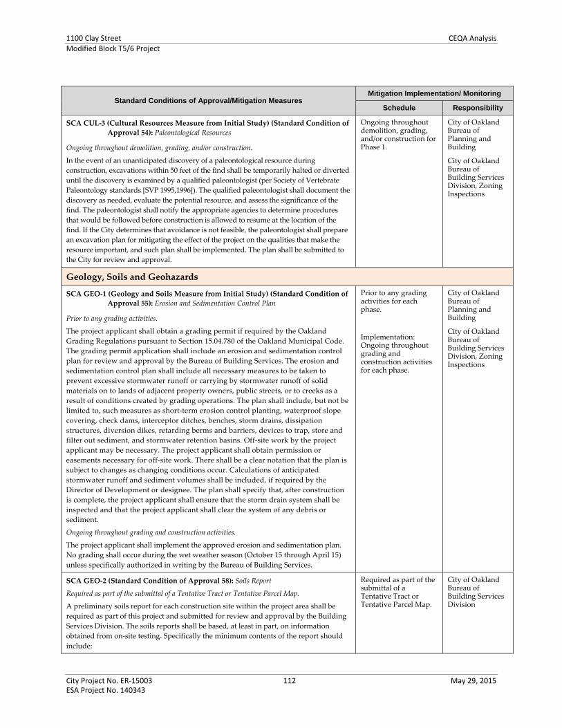
1100 Clay Street CEQA AnalysisModified Block T5/6 Project
City Project No. ER‐15003 112 May 29, 2015 ESA Project No. 140343
Standard Conditions of Approval/Mitigation Measures Mitigation Implementation/ Monitoring
Schedule Responsibility
SCA CUL‐3 (Cultural Resources Measure from Initial Study) (Standard Condition of
Approval 54): Paleontological Resources
Ongoing throughout demolition, grading, and/or construction.
In the event of an unanticipated discovery of a paleontological resource during
construction, excavations within 50 feet of the find shall be temporarily halted or diverted
until the discovery is examined by a qualified paleontologist (per Society of Vertebrate
Paleontology standards [SVP 1995,1996[). The qualified paleontologist shall document the
discovery as needed, evaluate the potential resource, and assess the significance of the
find. The paleontologist shall notify the appropriate agencies to determine procedures
that would be followed before construction is allowed to resume at the location of the
find. If the City determines that avoidance is not feasible, the paleontologist shall prepare
an excavation plan for mitigating the effect of the project on the qualities that make the
resource important, and such plan shall be implemented. The plan shall be submitted to
the City for review and approval.
Ongoing throughout demolition, grading, and/or construction for Phase 1.
City of Oakland Bureau of Planning and Building
City of Oakland Bureau of Building Services Division, Zoning Inspections
Geology, Soils and Geohazards
SCA GEO‐1 (Geology and Soils Measure from Initial Study) (Standard Condition of
Approval 55): Erosion and Sedimentation Control Plan
Prior to any grading activities.
The project applicant shall obtain a grading permit if required by the Oakland
Grading Regulations pursuant to Section 15.04.780 of the Oakland Municipal Code.
The grading permit application shall include an erosion and sedimentation control
plan for review and approval by the Bureau of Building Services. The erosion and
sedimentation control plan shall include all necessary measures to be taken to
prevent excessive stormwater runoff or carrying by stormwater runoff of solid
materials on to lands of adjacent property owners, public streets, or to creeks as a
result of conditions created by grading operations. The plan shall include, but not be
limited to, such measures as short‐term erosion control planting, waterproof slope
covering, check dams, interceptor ditches, benches, storm drains, dissipation
structures, diversion dikes, retarding berms and barriers, devices to trap, store and
filter out sediment, and stormwater retention basins. Off‐site work by the project
applicant may be necessary. The project applicant shall obtain permission or
easements necessary for off‐site work. There shall be a clear notation that the plan is
subject to changes as changing conditions occur. Calculations of anticipated
stormwater runoff and sediment volumes shall be included, if required by the
Director of Development or designee. The plan shall specify that, after construction
is complete, the project applicant shall ensure that the storm drain system shall be
inspected and that the project applicant shall clear the system of any debris or
sediment.
Ongoing throughout grading and construction activities.
The project applicant shall implement the approved erosion and sedimentation plan.
No grading shall occur during the wet weather season (October 15 through April 15)
unless specifically authorized in writing by the Bureau of Building Services.
Prior to any grading activities for each phase.
Implementation: Ongoing throughout grading and construction activities for each phase.
City of Oakland Bureau of Planning and Building
City of Oakland Bureau of Building Services Division, Zoning Inspections
SCA GEO‐2 (Standard Condition of Approval 58): Soils Report
Required as part of the submittal of a Tentative Tract or Tentative Parcel Map.
A preliminary soils report for each construction site within the project area shall be
required as part of this project and submitted for review and approval by the Building
Services Division. The soils reports shall be based, at least in part, on information
obtained from on‐site testing. Specifically the minimum contents of the report should
include:
Required as part of the submittal of a Tentative Tract or Tentative Parcel Map.
City of Oakland Bureau of Building Services Division

1100 Clay Street CEQA AnalysisModified Block T5/6 Project
City Project No. ER‐15003 113 May 29, 2015 ESA Project No. 140343
Standard Conditions of Approval/Mitigation Measures Mitigation Implementation/ Monitoring
Schedule Responsibility
a) Logs of borings and/or profiles of test pits and trenches:
1) The minimum number of borings acceptable, when not used in combination
with test pits or trenches, shall be two (2), when in the opinion of the Soils
Engineer such borings shall be sufficient to establish a soils profile suitable
for the design of all the footings, foundations, and retaining structures.
2) The depth of each boring shall be sufficient to provide adequate design
criteria for all proposed structures.
3) All boring logs shall be included in the soils report.
b) Test pits and trenches
1) Test pits and trenches shall be of sufficient length and depth to establish a
suitable soils profile for the design of all proposed structures.
2) Soils profiles of all test pits and trenches shall be included in the soils report.
c) A plat shall be included which shows the relationship of all the borings, test pits,
and trenches to the exterior boundary of the site. The plat shall also show the
location of all proposed site improvements. All proposed improvements shall be
labeled.
d) Copies of all data generated by the field and/or laboratory testing to determine
allowable soil bearing pressures, sheer strength, active and passive pressures,
maximum allowable slopes where applicable and any other information which
may be required for the proper design of foundations, retaining walls, and other
structures to be erected subsequent to or concurrent with work done under the
grading permit.
e) A written Soils Report shall be submitted which shall include but is not limited to
the following:
1) Site description
2) Local and site geology
3) Review of previous field and laboratory investigations for the site
4) Review of information on or in the vicinity of the site on file at the
Information Counter, City of Oakland, Office of Planning and Building.
5) Site stability shall be addressed with particular attention to existing
conditions and proposed corrective attention to existing conditions and
proposed corrective actions at locations where land stability problems exist.
6) Conclusions and recommendations for foundations and retaining structures,
resistance to lateral loading, slopes, and specifications, for fills, and
pavement design as required.
7) Conclusions and recommendations for temporary and permanent erosion
control and drainage. If not provided in a separate report they shall be
appended to the required soils report.
8) All other items which a Soils Engineer deems necessary.
9) The signature and registration number of the Civil Engineer preparing the
report.
The Director of Planning and Building may reject a report that she/he believes is not
sufficient. The Director of Planning and Building may refuse to accept a soils report if the
certification date of the responsible soils engineer on said document is more than three

1100 Clay Street CEQA AnalysisModified Block T5/6 Project
City Project No. ER‐15003 114 May 29, 2015 ESA Project No. 140343
Standard Conditions of Approval/Mitigation Measures Mitigation Implementation/ Monitoring
Schedule Responsibility
years old. In this instance, the Director may be require that the old soils report be
recertified, that an addendum to the soils report be submitted, or that a new soils report
be provided.
SCA GEO‐3 (Standard Condition of Approval 60): Geotechnical Report
Required as part of the submittal of a Tentative Tract Map or Tentative Parcel Map.
A site‐specific, design level, Landslide or Liquefaction geotechnical investigation for
each construction site within the project area shall be required as part of this project
and submitted for review and approval by the Bureau of Building Services.
Specifically:
1) Each investigation shall include an analysis of expected ground motions at the site
from identified faults. The analyses shall be accordance with applicable City
ordinances and polices, and consistent with the most recent version of the
California Building Code, which requires structural design that can accommodate
ground accelerations expected from identified faults.
2) The investigations shall determine final design parameters for the walls,
foundations, foundation slabs, surrounding related improvements, and
infrastructure (utilities, roadways, parking lots, and sidewalks).
3) The investigations shall be reviewed and approved by a registered geotechnical
engineer. All recommendations by the project engineer, geotechnical engineer,
shall be included in the final design, as approved by the City of Oakland.
4) The geotechnical report shall include a map prepared by a land surveyor or civil
engineer that shows all field work and location of the “No Build” zone. The map
shall include a statement that the locations and limitations of the geologic features
are accurate representations of said features as they exist on the ground, were
placed on this map by the surveyor, the civil engineer or under their supervision,
and are accurate to the best of their knowledge.
5) Recommendations that are applicable to foundation design, earthwork, and site
preparation that were prepared prior to or during the projectʹs design phase, shall
be incorporated in the project.
6) Final seismic considerations for the site shall be submitted to and approved by the
City of Oakland Bureau of Building Services prior to commencement of the
project.
7) A peer review is required for the Geotechnical Report. Personnel reviewing the
geologic report shall approve the report, reject it, or withhold approval pending
the submission by the applicant or subdivider of further geologic and engineering
studies to more adequately define active fault traces.
Tentative Tract or Parcel Map approvals shall require, but not be limited to, approval
of the Geotechnical Report.
Required as part of the submittal of a Tentative Tract Map or Tentative Parcel Map.
City of Oakland Bureau of Building Services Division
City of Oakland Public Works Department, Tree Services Division
Also SCA HYD‐4. See Hydrology and Water Quality, below.
Greenhouse Gases and Climate Change
SCAs UTIL‐1 and UTIL‐2. See Utilities and Service Systems, below.
Hazards and Hazardous Materials
SCA HAZ‐1 (Hazards and Hazardous Materials Measure from initial Study) (Standard
Condition of Approval 35): Hazards Best Management Practices
Prior to the commencement of demolition, grading, or construction.
Prior to the commencement of demolition, grading, or construction for each
City of Oakland Bureau of Building Services
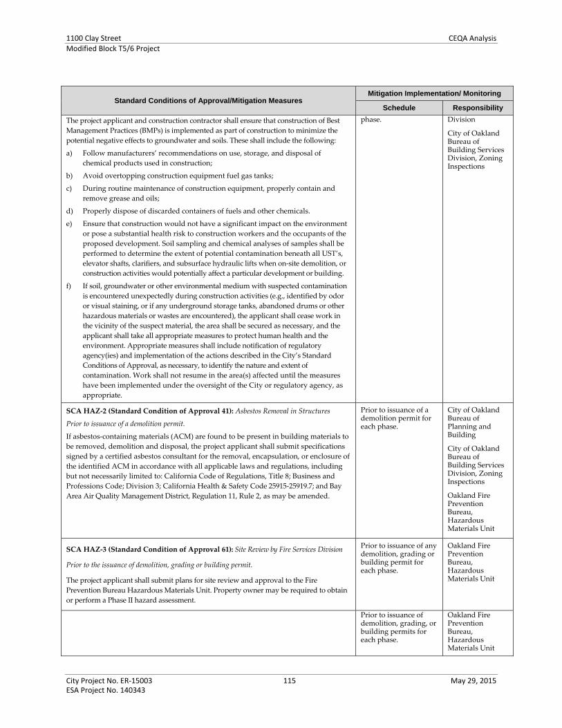
1100 Clay Street CEQA AnalysisModified Block T5/6 Project
City Project No. ER‐15003 115 May 29, 2015 ESA Project No. 140343
Standard Conditions of Approval/Mitigation Measures Mitigation Implementation/ Monitoring
Schedule Responsibility
The project applicant and construction contractor shall ensure that construction of Best
Management Practices (BMPs) is implemented as part of construction to minimize the
potential negative effects to groundwater and soils. These shall include the following:
a) Follow manufacturers’ recommendations on use, storage, and disposal of
chemical products used in construction;
b) Avoid overtopping construction equipment fuel gas tanks;
c) During routine maintenance of construction equipment, properly contain and
remove grease and oils;
d) Properly dispose of discarded containers of fuels and other chemicals.
e) Ensure that construction would not have a significant impact on the environment
or pose a substantial health risk to construction workers and the occupants of the
proposed development. Soil sampling and chemical analyses of samples shall be
performed to determine the extent of potential contamination beneath all UST’s,
elevator shafts, clarifiers, and subsurface hydraulic lifts when on‐site demolition, or
construction activities would potentially affect a particular development or building.
f) If soil, groundwater or other environmental medium with suspected contamination
is encountered unexpectedly during construction activities (e.g., identified by odor
or visual staining, or if any underground storage tanks, abandoned drums or other
hazardous materials or wastes are encountered), the applicant shall cease work in
the vicinity of the suspect material, the area shall be secured as necessary, and the
applicant shall take all appropriate measures to protect human health and the
environment. Appropriate measures shall include notification of regulatory
agency(ies) and implementation of the actions described in the City’s Standard
Conditions of Approval, as necessary, to identify the nature and extent of
contamination. Work shall not resume in the area(s) affected until the measures
have been implemented under the oversight of the City or regulatory agency, as
appropriate.
phase. Division
City of Oakland Bureau of Building Services Division, Zoning Inspections
SCA HAZ‐2 (Standard Condition of Approval 41): Asbestos Removal in Structures
Prior to issuance of a demolition permit.
If asbestos‐containing materials (ACM) are found to be present in building materials to
be removed, demolition and disposal, the project applicant shall submit specifications
signed by a certified asbestos consultant for the removal, encapsulation, or enclosure of
the identified ACM in accordance with all applicable laws and regulations, including
but not necessarily limited to: California Code of Regulations, Title 8; Business and
Professions Code; Division 3; California Health & Safety Code 25915‐25919.7; and Bay
Area Air Quality Management District, Regulation 11, Rule 2, as may be amended.
Prior to issuance of a demolition permit for each phase.
City of Oakland Bureau of Planning and Building
City of Oakland Bureau of Building Services Division, Zoning Inspections
Oakland Fire Prevention Bureau, Hazardous Materials Unit
SCA HAZ‐3 (Standard Condition of Approval 61): Site Review by Fire Services Division
Prior to the issuance of demolition, grading or building permit.
The project applicant shall submit plans for site review and approval to the Fire
Prevention Bureau Hazardous Materials Unit. Property owner may be required to obtain
or perform a Phase II hazard assessment.
Prior to issuance of any demolition, grading or building permit for each phase.
Oakland Fire Prevention Bureau, Hazardous Materials Unit
Prior to issuance of demolition, grading, or building permits for each phase.
Oakland Fire Prevention Bureau, Hazardous Materials Unit

1100 Clay Street CEQA AnalysisModified Block T5/6 Project
City Project No. ER‐15003 116 May 29, 2015 ESA Project No. 140343
Standard Conditions of Approval/Mitigation Measures Mitigation Implementation/ Monitoring
Schedule Responsibility
SCA HAZ‐5 (Standard Condition of Approval 63): Lead‐Based Paint/Coatings, Asbestos,
or PCB Occurrence Assessment
Prior to issuance of any demolition, grading or building permit.
The project applicant shall submit a comprehensive assessment report to the Fire
Prevention Bureau, Hazardous Materials Unit, signed by a qualified environmental
professional, documenting the presence or lack thereof of asbestos‐containing materials
(ACM), lead‐based paint, and any other building materials or stored materials
classified as hazardous waste by State or federal law.
Prior to issuance of any demolition, grading or building permit for each phase.
City of Oakland Bureau of Planning and Building
City of Oakland Bureau of Building Services Division, Zoning Inspections
Oakland Fire Prevention Bureau, Hazardous Materials Unit
SCA HAZ‐6 (Standard Condition of Approval 64): Environmental Site Assessment
Reports Remediation:
Prior to issuance of any demolition, grading or building permit.
If the environmental site assessment reports recommend remedial action, the project
applicant shall:
a) Consult with the appropriate local, State, and federal environmental regulatory
agencies to ensure sufficient minimization of risk to human health and
environmental resources, both during and after construction, posed by soil
contamination, groundwater contamination, or other surface hazards including, but
not limited to, underground storage tanks, fuel distribution lines, waste pits and
sumps.
b) Obtain and submit written evidence of approval for any remedial action if required
by a local, State, or federal environmental regulatory agency.
c) Submit a copy of all applicable documentation required by local, State, and federal
environmental regulatory agencies, including but not limited to: permit
applications, Phase I and II environmental site assessments, human health and
ecological risk assessments, remedial action plans, risk management plans, soil
management plans, and groundwater management plans.
Prior to issuance of any demolition, grading or building permit for each phase.
City of Oakland Bureau of Planning and Building
City of Oakland Bureau of Building Services Division, Zoning Inspections
Oakland Fire Prevention Bureau, Hazardous Materials Unit
SCA HAZ‐7 (Standard Condition of Approval 65): Lead‐base Paint Remediation
Prior to issuance of any demolition, grading or building permit.
If lead‐based paint is present, the project applicant shall submit specifications to the
Fire Prevention Bureau, Hazardous Materials Unit signed by a certified Lead Supervisor,
Project Monitor, or Project Designer for the stabilization and/or removal of the
identified lead paint in accordance with all applicable laws and regulations, including
but not necessarily limited to: Cal/OSHA’s Construction Lead Standard, 8 CCR1532.1
and DHS regulation 17 CCR Sections 35001 through 36100, as may be amended.
Prior to issuance of any demolition, grading or building permit for each phase.
City of Oakland Bureau of Planning and Building
City of Oakland Bureau of Building Services Division, Zoning Inspections
Oakland Fire Prevention Bureau, Hazardous Materials Unit
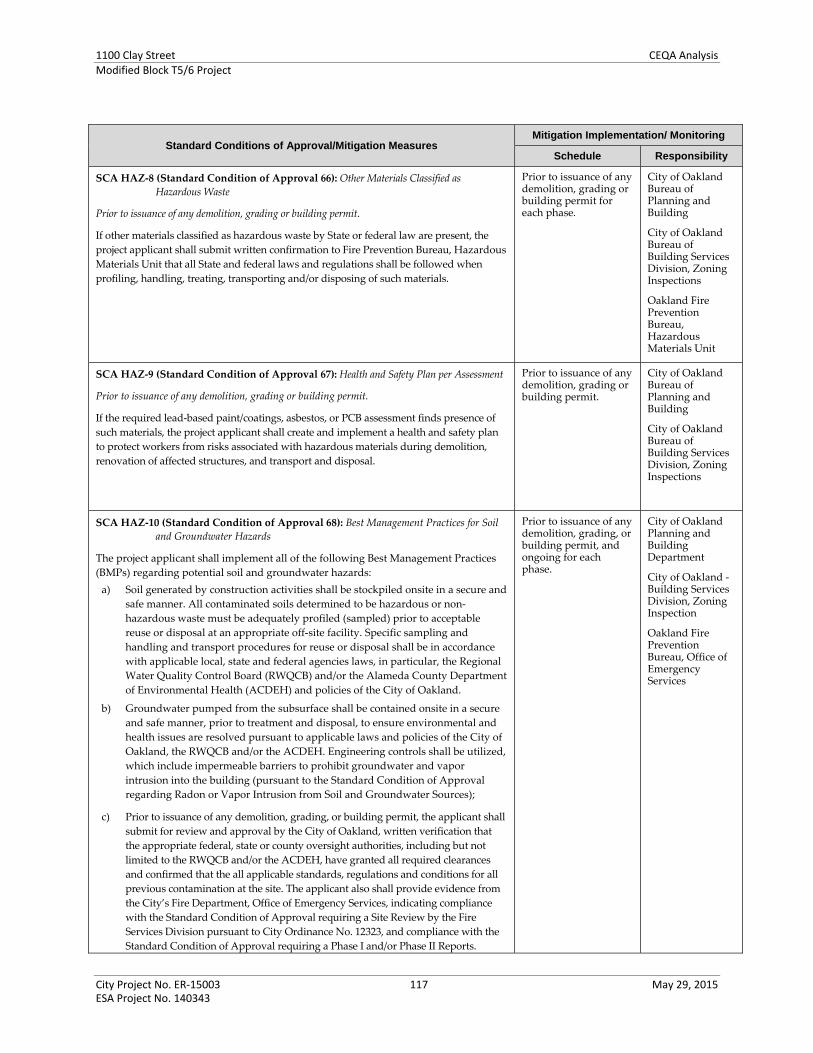
1100 Clay Street CEQA AnalysisModified Block T5/6 Project
City Project No. ER‐15003 117 May 29, 2015 ESA Project No. 140343
Standard Conditions of Approval/Mitigation Measures Mitigation Implementation/ Monitoring
Schedule Responsibility
SCA HAZ‐8 (Standard Condition of Approval 66): Other Materials Classified as
Hazardous Waste
Prior to issuance of any demolition, grading or building permit.
If other materials classified as hazardous waste by State or federal law are present, the
project applicant shall submit written confirmation to Fire Prevention Bureau, Hazardous
Materials Unit that all State and federal laws and regulations shall be followed when
profiling, handling, treating, transporting and/or disposing of such materials.
Prior to issuance of any demolition, grading or building permit for each phase.
City of Oakland Bureau of Planning and Building
City of Oakland Bureau of Building Services Division, Zoning Inspections
Oakland Fire Prevention Bureau, Hazardous Materials Unit
SCA HAZ‐9 (Standard Condition of Approval 67): Health and Safety Plan per Assessment
Prior to issuance of any demolition, grading or building permit.
If the required lead‐based paint/coatings, asbestos, or PCB assessment finds presence of
such materials, the project applicant shall create and implement a health and safety plan
to protect workers from risks associated with hazardous materials during demolition,
renovation of affected structures, and transport and disposal.
Prior to issuance of any demolition, grading or building permit.
City of Oakland Bureau of Planning and Building
City of Oakland Bureau of Building Services Division, Zoning Inspections
SCA HAZ‐10 (Standard Condition of Approval 68): Best Management Practices for Soil
and Groundwater Hazards
The project applicant shall implement all of the following Best Management Practices
(BMPs) regarding potential soil and groundwater hazards:
a) Soil generated by construction activities shall be stockpiled onsite in a secure and
safe manner. All contaminated soils determined to be hazardous or non‐
hazardous waste must be adequately profiled (sampled) prior to acceptable
reuse or disposal at an appropriate off‐site facility. Specific sampling and
handling and transport procedures for reuse or disposal shall be in accordance
with applicable local, state and federal agencies laws, in particular, the Regional
Water Quality Control Board (RWQCB) and/or the Alameda County Department
of Environmental Health (ACDEH) and policies of the City of Oakland.
b) Groundwater pumped from the subsurface shall be contained onsite in a secure
and safe manner, prior to treatment and disposal, to ensure environmental and
health issues are resolved pursuant to applicable laws and policies of the City of
Oakland, the RWQCB and/or the ACDEH. Engineering controls shall be utilized,
which include impermeable barriers to prohibit groundwater and vapor
intrusion into the building (pursuant to the Standard Condition of Approval
regarding Radon or Vapor Intrusion from Soil and Groundwater Sources);
c) Prior to issuance of any demolition, grading, or building permit, the applicant shall
submit for review and approval by the City of Oakland, written verification that
the appropriate federal, state or county oversight authorities, including but not
limited to the RWQCB and/or the ACDEH, have granted all required clearances
and confirmed that the all applicable standards, regulations and conditions for all
previous contamination at the site. The applicant also shall provide evidence from
the City’s Fire Department, Office of Emergency Services, indicating compliance
with the Standard Condition of Approval requiring a Site Review by the Fire
Services Division pursuant to City Ordinance No. 12323, and compliance with the
Standard Condition of Approval requiring a Phase I and/or Phase II Reports.
Prior to issuance of any demolition, grading, or building permit, and ongoing for each phase.
City of Oakland Planning and Building Department
City of Oakland ‐ Building Services Division, Zoning Inspection
Oakland Fire Prevention Bureau, Office of Emergency Services

1100 Clay Street CEQA AnalysisModified Block T5/6 Project
City Project No. ER‐15003 118 May 29, 2015 ESA Project No. 140343
Standard Conditions of Approval/Mitigation Measures Mitigation Implementation/ Monitoring
Schedule Responsibility
SCA HAZ‐11 (Standard Condition of Approval 69): Radon or Vapor Intrusion from
Soil or Groundwater Sources
Ongoing.
The project applicant shall submit documentation to determine whether radon or
vapor intrusion from the groundwater and soil is located on‐site as part of the Phase I
documents. The Phase I analysis shall be submitted to the Fire Prevention Bureau,
Hazardous Materials Unit, for review and approval, along with a Phase II report if
warranted by the Phase I report for the project site. The reports shall make
recommendations for remedial action, if appropriate, and should be signed by a
Registered Environmental Assessor, Professional Geologist, or Professional Engineer.
Applicant shall implement the approved recommendations.
Submittal with Phase I and/or Phase II documents, prior to issuance of a demolition, grading or building permit for each phase.
Ongoing if remediation actions are recommended.
City of Oakland Bureau of Planning and Building
City of Oakland Bureau of Building Services Division, Zoning Inspections
Oakland Fire Prevention Bureau, Hazardous Materials Unit
SCA HAZ‐12 (Standard Condition of Approval 74): Hazardous Materials Business Plan
Prior to issuance of a business license.
The project applicant shall submit a Hazardous Materials Business Plan for review and
approval by Fire Prevention Bureau, Hazardous Materials Unit. Once approved this plan
shall be kept on file with the City and will be updated as applicable. The purpose of the
Hazardous Business Plan is to ensure that employees are adequately trained to handle
the materials and provides information to the Fire Services Division should emergency
response be required. The Hazardous Materials Business Plan shall include the following:
a) The types of hazardous materials or chemicals stored and/or used on site, such
as petroleum fuel products, lubricants, solvents, and cleaning fluids.
b) The location of such hazardous materials.
c) An emergency response plan including employee training information.
d) A plan that describes the manner in which these materials are handled,
transported and disposed.
Prior to issuance of a business license for each phase.
City of Oakland Bureau of Planning and Building
City of Oakland Bureau of Building Services Division, Zoning Inspections
Oakland Fire Prevention Bureau, Hazardous Materials Unit
Hydrology and Water Quality
SCA HYD‐1 (Hydrology and Water Quality Measure from Initial Study) (Standard
Condition of Approval 75): Stormwater Pollution Prevention Plan
Prior to and ongoing throughout demolition, grading, and/or construction activities.
The project applicant must obtain coverage under the General Construction Activity
Storm Water Permit (General Construction Permit) issued by the State Water
Resources Control Board (SWRCB). The project applicant must file a notice of intent
(NOI) with the SWRCB. The project applicant will be required to prepare a
stormwater pollution prevention plan (SWPPP) and submit the plan for review and
approval by the Bureau of Building Services. At a minimum, the SWPPP shall
include a description of construction materials, practices, and equipment storage and
maintenance; a list of pollutants likely to contact stormwater; site‐specific erosion
and sedimentation control practices; a list of provisions to eliminate or reduce
discharge of materials to stormwater; Best Management Practices (BMPs), and an
inspection and monitoring program. Prior to the issuance of any construction‐related
permits, the project applicant shall submit to the Bureau of Building Services a copy
of the SWPPP and evidence of submittal of the NOI to the SWRCB. Implementation
of the SWPPP shall start with the commencement of construction and continue
through the completion of the project. After construction is completed, the project
applicant shall submit a notice of termination to the SWRCB.
Prior to and ongoing throughout demolition, grading, and/or construction activities for each phase.
City of Oakland Bureau of Planning and Building
City of Oakland Bureau of Building Services Division, Zoning Inspections

1100 Clay Street CEQA AnalysisModified Block T5/6 Project
City Project No. ER‐15003 119 May 29, 2015 ESA Project No. 140343
Standard Conditions of Approval/Mitigation Measures Mitigation Implementation/ Monitoring
Schedule Responsibility
SCA HYD‐2 (Hydrology and Water Quality Measure from Initial Study) (Standard
Condition of Approval 80): Post‐construction Stormwater Management Plan
Prior to issuance of building permit (or other construction‐related permit).
The applicant shall comply with the requirements of Provision C.3 of the National
Pollutant Discharge Elimination System (NPDES) permit issued to the Alameda
Countywide Clean Water Program. The applicant shall submit with the application
for a building permit (or other construction‐related permit) a completed
Construction‐Permit‐Phase Stormwater Supplemental Form to the Bureau of
Building Services. The project drawings submitted for the building permit (or other
construction‐related permit) shall contain a stormwater management plan, for
review and approval by the City, to manage stormwater run‐off and to limit the
discharge of pollutants in stormwater after construction of the project to the
maximum extent practicable.
a) The post‐construction stormwater management plan shall include and identify
the following:
1) All proposed impervious surface on the site;
2) Anticipated directional flows of on‐site stormwater runoff; and
3) Site design measures to reduce the amount of impervious surface area and
directly connected impervious surfaces; and
4) Source control measures to limit the potential for stormwater pollution;
5) Stormwater treatment measures to remove pollutants from stormwater runoff;
and
6) Hydromodification management measures so that post‐project stormwater
runoff does not exceed the flow and duration of pre‐project runoff, if required
under the NPDES permit.
b) The following additional information shall be submitted with the post‐
construction stormwater management plan:
1) Detailed hydraulic sizing calculations for each stormwater treatment measure
proposed; and
2) Pollutant removal information demonstrating that any proposed
manufactured/ mechanical (i.e., non‐landscape‐based) stormwater treatment
measure, when not used in combination with a landscape‐based treatment
measure, is capable or removing the range of pollutants typically removed by
landscape‐based treatment measures and/or the range of pollutants expected
to be generated by the project.
All proposed stormwater treatment measures shall incorporate appropriate planting
materials for stormwater treatment (for landscape‐based treatment measures) and
shall be designed with considerations for vector/mosquito control. Proposed
planting materials for all proposed landscape‐based stormwater treatment measures
shall be included on the landscape and irrigation plan for the project. The applicant
is not required to include on‐site stormwater treatment measures in the post‐
construction stormwater management plan if he or she secures approval from the
Bureau of Planning of a proposal that demonstrates compliance with the
requirements of the City’s Alternative Compliance Program.
Prior to final permit inspection.
The applicant shall implement the approved stormwater management plan.
Construction‐Permit‐Phase Stormwater Supplemental Form Submittal: Prior to issuance of building permit (or other construction‐related permit) for each phase.
Implement SWP: Prior to final permit inspection for each phase.
City of Oakland Bureau of Planning and Building
City of Oakland Bureau of Building Services Division, Zoning Inspections
SCA HYD‐3 (Hydrology and Water Quality Measure from Initial Study) (Standard Prior to final zoning City of Oakland

1100 Clay Street CEQA AnalysisModified Block T5/6 Project
City Project No. ER‐15003 120 May 29, 2015 ESA Project No. 140343
Standard Conditions of Approval/Mitigation Measures Mitigation Implementation/ Monitoring
Schedule Responsibility
Condition of Approval 81): Maintenance Agreement for Stormwater
Treatment Measures
Prior to final zoning inspection.
For projects incorporating stormwater treatment measures, the applicant shall enter
into the “Standard City of Oakland Stormwater Treatment Measures Maintenance
Agreement,” in accordance with Provision C.3.e of the NPDES permit, which
provides, in part, for the following: The applicant accepting responsibility for the
adequate installation/construction, operation, maintenance, inspection, and
reporting of any on‐site stormwater treatment measures being incorporated into the
project until the responsibility is legally transferred to another entity; and
Legal access to the on‐site stormwater treatment measures for representatives of the
City, the local vector control district, and staff of the Regional Water Quality Control
Board, San Francisco Region, for the purpose of verifying the implementation,
operation, and maintenance of the on‐site stormwater treatment measures and to
take corrective action if necessary. The agreement shall be recorded at the County
Recorder’s Office at the applicant’s expense.
inspection. Bureau of Planning and Building
City of Oakland Bureau of Building Services Division, Zoning Inspections
City of Oakland – Public Works Department, Sewer and Stormwater Division
SCA HYD‐4 (Standard Condition of Approval 78): Site Design Measures for Post‐
Construction Stormwater Management
Prior to issuance of building permit (or other construction‐related permit)
The project drawings submitted for a building permit (or other construction‐related
permit) shall contain a final site plan to be reviewed and approved by the Bureau of
Planning. The final site plan shall incorporate appropriate site design measures to
manage stormwater runoff and minimize impacts to water quality after the
construction of the project. These measures may include, but are not limited to, the
following:
a) Minimize impervious surfaces, especially directly connected impervious surfaces;
b) Utilize permeable paving in place of impervious paving where appropriate;
c) Cluster buildings;
d) Preserve quality open space; and
e) Establish vegetated buffer areas.
Ongoing.
The approved plan shall be implemented and the site design measures shown on the
plan shall be permanently maintained.
Prior to issuance of building permit (or other construction‐related permit) for each phase.
Implementation: Ongoing for each phase.
City of Oakland Bureau of Planning and Building
City of Oakland Bureau of Building Services Division, Zoning Inspections
SCA HYD‐5 (Standard Condition of Approval 79): Source Control Measures to Limit
Stormwater Pollution
Prior to issuance of building permit (or other construction‐related permit).
The applicant shall implement and maintain all structural source control measures
imposed by the Chief of Building Services to limit the generation, discharge, and runoff
of stormwater pollution.
Ongoing. The applicant, or his or her successor, shall implement all operational Best
Management Practices (BMPs) imposed by the Chief of Building Services to limit the
generation, discharge, and runoff of stormwater pollution.
Prior to issuance of building permit (or other construction‐related permit) for each phase.
City of Oakland Bureau of Planning and Building
City of Oakland Bureau of Building Services Division, Zoning Inspections
SCA HYD‐6 (Standard Condition of Approval 82): Erosion, Sedimentation, and Debris
Control Measures
Prior to issuance of demolition, grading, or construction‐related permit.
The project applicant shall submit an erosion and sedimentation control plan for
review and approval by the Building Services Division. All work shall incorporate all
applicable “Best Management Practices (BMPs) for the construction industry, and as
Prior to issuance of demolition, grading, or construction‐related permit for each phase.
City of Oakland Bureau of Planning and Building
City of Oakland Bureau of Building Services Division, Zoning

1100 Clay Street CEQA AnalysisModified Block T5/6 Project
City Project No. ER‐15003 121 May 29, 2015 ESA Project No. 140343
Standard Conditions of Approval/Mitigation Measures Mitigation Implementation/ Monitoring
Schedule Responsibility
outlined in the Alameda Countywide Clean Water Program pamphlets, including
BMP’s for dust, erosion and sedimentation abatement per Chapter Section 15.04 of the
Oakland Municipal Code. The measures shall include, but are not limited to, the
following:
a) On sloped properties, the downhill end of the construction area must be protected
with silt fencing (such as sandbags, filter fabric, silt curtains, etc.) and hay bales
oriented parallel to the contours of the slope (at a constant elevation) to prevent
erosion into the creek.
b) In accordance with an approved erosion control plan, the project applicant shall
implement mechanical and vegetative measures to reduce erosion and
sedimentation, including appropriate seasonal maintenance. One hundred (100)
percent degradable erosion control fabric shall be installed on all graded slopes to
protect and stabilize the slopes during construction and before permanent
vegetation gets established. All graded areas shall be temporarily protected from
erosion by seeding with fast growing annual species. All bare slopes must be
covered with staked tarps when rain is occurring or is expected.
c) Minimize the removal of natural vegetation or ground cover from the site in order
to minimize the potential for erosion and sedimentation problems. Maximize the
replanting of the area with native vegetation as soon as possible.
d) All work in or near creek channels must be performed with hand tools and by a
minimum number of people. Immediately upon completion of this work, soil must
be repacked and native vegetation planted.
e) Install filter materials (such as sandbags, filter fabric, etc.) acceptable to the
Engineering Division at the storm drain inlets nearest to the project site prior to the
start of the wet weather season (October 15); site dewatering activities; street
washing activities; saw cutting asphalt or concrete; and in order to retain any debris
flowing into the City storm drain system. Filter materials shall be maintained
and/or replaced as necessary to ensure effectiveness and prevent street flooding.
f) Ensure that concrete/granite supply trucks or concrete/plaster finishing operations
do not discharge wash water into the creek, street gutters, or storm drains.
g) Direct and locate tool and equipment cleaning so that wash water does not
discharge into the creek.
h) Create a contained and covered area on the site for storage of bags of cement,
paints, flammables, oils, fertilizers, pesticides, or any other materials used on the
project site that have the potential for being discharged to the storm drain system
by the wind or in the event of a material spill. No hazardous waste material shall be
stored on site.
i) Gather all construction debris on a regular basis and place them in a dumpster or
other container which is emptied or removed on a weekly basis. When appropriate,
use tarps on the ground to collect fallen debris or splatters that could contribute to
stormwater pollution.
j) Remove all dirt, gravel, refuse, and green waste from the sidewalk, street
pavement, and storm drain system adjoining the project site. During wet weather,
avoid driving vehicles off paved areas and other outdoor work.
k) Broom sweep the street pavement adjoining the project site on a daily basis. Caked‐
on mud or dirt shall be scraped from these areas before sweeping. At the end of
each workday, the entire site must be cleaned and secured against potential
erosion, dumping, or discharge to the creek, street, gutter, stormdrains.
l) All erosion and sedimentation control measures implemented during construction
activities, as well as construction site and materials management shall be in strict
accordance with the control standards listed in the latest edition of the Erosion and
Inspections
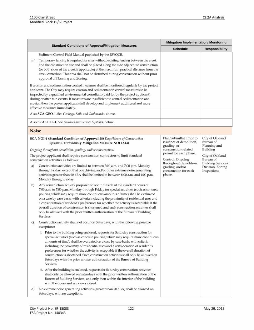
1100 Clay Street CEQA AnalysisModified Block T5/6 Project
City Project No. ER‐15003 122 May 29, 2015 ESA Project No. 140343
Standard Conditions of Approval/Mitigation Measures Mitigation Implementation/ Monitoring
Schedule Responsibility
Sediment Control Field Manual published by the RWQCB.
m) Temporary fencing is required for sites without existing fencing between the creek
and the construction site and shall be placed along the side adjacent to construction
(or both sides of the creek if applicable) at the maximum practical distance from the
creek centerline. This area shall not be disturbed during construction without prior
approval of Planning and Zoning.
lf erosion and sedimentation control measures shall be monitored regularly by the project
applicant. The City may require erosion and sedimentation control measures to be
inspected by a qualified environmental consultant (paid for by the project applicant)
during or after rain events. If measures are insufficient to control sedimentation and
erosion then the project applicant shall develop and implement additional and more
effective measures immediately.
Also SCA GEO‐1. See Geology, Soils and Geohazards, above.
Also SCA UTIL‐1. See Utilities and Service Systems, below.
Noise
SCA NOI‐1 (Standard Condition of Approval 28) Days/Hours of Construction
Operation) (Previously Mitigation Measure NOI D.1a)
Ongoing throughout demolition, grading, and/or construction.
The project applicant shall require construction contractors to limit standard
construction activities as follows:
a) Construction activities are limited to between 7:00 a.m. and 7:00 p.m. Monday
through Friday, except that pile driving and/or other extreme noise generating
activities greater than 90 dBA shall be limited to between 8:00 a.m. and 4:00 p.m.
Monday through Friday.
b) Any construction activity proposed to occur outside of the standard hours of
7:00 a.m. to 7:00 p.m. Monday through Friday for special activities (such as concrete
pouring which may require more continuous amounts of time) shall be evaluated
on a case by case basis, with criteria including the proximity of residential uses and
a consideration of resident’s preferences for whether the activity is acceptable if the
overall duration of construction is shortened and such construction activities shall
only be allowed with the prior written authorization of the Bureau of Building
Services.
c) Construction activity shall not occur on Saturdays, with the following possible
exceptions:
i. Prior to the building being enclosed, requests for Saturday construction for
special activities (such as concrete pouring which may require more continuous
amounts of time), shall be evaluated on a case by case basis, with criteria
including the proximity of residential uses and a consideration of resident’s
preferences for whether the activity is acceptable if the overall duration of
construction is shortened. Such construction activities shall only be allowed on
Saturdays with the prior written authorization of the Bureau of Building
Services.
ii. After the building is enclosed, requests for Saturday construction activities shall only be allowed on Saturdays with the prior written authorization of the
Bureau of Building Services, and only then within the interior of the building
with the doors and windows closed.
d) No extreme noise generating activities (greater than 90 dBA) shall be allowed on
Saturdays, with no exceptions.
Plan Submittal: Prior to issuance of demolition, grading, or construction‐related permit for each phase.
Control: Ongoing throughout demolition, grading, and/or construction for each phase.
City of Oakland Bureau of Planning and Building
City of Oakland Bureau of Building Services Division, Zoning Inspections

1100 Clay Street CEQA AnalysisModified Block T5/6 Project
City Project No. ER‐15003 123 May 29, 2015 ESA Project No. 140343
Standard Conditions of Approval/Mitigation Measures Mitigation Implementation/ Monitoring
Schedule Responsibility
e) No construction activity shall take place on Sundays or federal holidays.
f) Construction activities include but are not limited to: truck idling, moving
equipment (including trucks, elevators, etc.) or materials, deliveries, and
construction meetings held on‐site in a non‐enclosed area.
g) Applicant shall use temporary power poles instead of generators where feasible.
SCA NOI‐2: (Standard Condition of Approval 29: Noise Control (Previously Mitigation Measure NOI D.1b)
Ongoing throughout demolition, grading, and/or construction.
To reduce noise impacts due to construction, the project applicant shall require
construction contractors to implement a site‐specific noise reduction program, subject
to the Bureau of Planning and the Bureau of Building Services review and approval,
which includes the following measures:
a) Equipment and trucks used for project construction shall utilize the best
available noise control techniques (e.g., improved mufflers, equipment redesign,
use of intake silencers, ducts, engine enclosures and acoustically‐attenuating
shields or shrouds, wherever feasible).
b) Except as provided herein, impact tools (e.g., jack hammers, pavement breakers,
and rock drills) used for project construction shall be hydraulically or electrically
powered wherever possible to avoid noise associated with compressed air
exhaust from pneumatically powered tools. However, where use of pneumatic
tools is unavoidable, an exhaust muffler on the compressed air exhaust shall be
used; this muffler can lower noise levels from the exhaust by up to about 10 dBA.
External jackets on the tools themselves shall be used, is such jackets are
commercially available and this could achieve a reduction of 5 dBA. Quieter
procedures shall be used, such as drills rather than impact equipment, whenever
such procedures are available and consistent with construction procedures.
c) Stationary noise sources shall be located as far from adjacent receptors as possible,
and they shall be muffled and enclosed within temporary sheds, incorporate
insulation barriers, or other measures as determined by the City to provide
equivalent noise reduction.
d) The noisiest phases of construction shall be limited to less than 10 days at a time.
Exceptions may be allowed if the City determined an extension is necessary and
all available noise reduction controls are implemented.
Implementation of this measure would reduce the anticipated impact to less‐than‐
significant levels.
Plan Submittal: Prior to issuance of demolition, grading, or construction‐related permit for each phase.
Control: Ongoing throughout demolition, grading, and/or construction for each phase.
City of Oakland Bureau of Planning and Building
City of Oakland Bureau of Building Services Division, Zoning Inspections
SCA NOI‐3 (Standard Condition of Approval 39: Pile Driving and Other Extreme Noise
Generators (Previously Mitigation Measure NOI D.1c)
Ongoing throughout demolition, grading, and/or construction.
To further reduce potential pier drilling, pile driving and/or other extreme noise
generating construction impacts greater than 90 dBA, a set of site‐specific noise
attenuation measures shall be completed under the supervision of a qualified acoustical
consultant. Prior to commencing construction, a plan for such measures shall be
submitted for review and approval by the Bureau of Planning and the Bureau of Building
Services to ensure that maximum feasible noise attenuation will be achieved. This plan
shall be based on the final design of the project. A third‐party peer review, paid for by the
project applicant, may be required to assist the City in evaluating the feasibility and
effectiveness of the noise reduction plan submitted by the project applicant. A special
inspection deposit is required to ensure compliance with the noise reduction plan. The
amount of the deposit shall be determined by the Building Official, and the deposit shall
Plan Submittal: Prior to issuance of demolition, grading, or construction‐related permit for each phase.
Control: Ongoing throughout demolition, grading, and/or construction for each phase.
City of Oakland Bureau of Planning and Building
City of Oakland Bureau of Building Services Division, Zoning Inspections

1100 Clay Street CEQA AnalysisModified Block T5/6 Project
City Project No. ER‐15003 124 May 29, 2015 ESA Project No. 140343
Standard Conditions of Approval/Mitigation Measures Mitigation Implementation/ Monitoring
Schedule Responsibility
be submitted by the project applicant concurrent with submittal of the noise reduction
plan. The noise reduction plan shall include, but not be limited to, an evaluation of the
following measures. These attenuation measures shall include as many of the following
control strategies as applicable to the site and construction activity:
a) Erect temporary plywood noise barriers around the construction site, particularly
along on sites adjacent to residential buildings;
b) Implement “quiet” pile driving technology (such as pre‐drilling of piles, the use of
more than one pile driver to shorten the total pile driving duration), where
feasible, in consideration of geotechnical and structural requirements and
conditions;
c) Utilize noise control blankets on the building structure as the building is erected
to reduce noise emission from the site;
d) Evaluate the feasibility of noise control at the receivers by temporarily improving
the noise reduction capability of adjacent buildings by the use of sound blankets
for example; and
e) Monitor the effectiveness of noise attenuation measures by taking noise
measurements.
Implementation of this measure would reduce the anticipated impact to less‐than‐
significant levels.
SCA NOI‐4: (Standard Condition of Approval 30): Noise Complaint Procedures
(Previously Mitigation Measure NOI D.1d)
Prior to the issuance of each building permit, along with the submission of construction
documents. Then ongoing throughout demolition, grading, and/or construction.
The project applicant shall submit to the Bureau of Building Services a list of measures
to respond to and track complaints pertaining to construction noise. These measures
shall include:
a) A procedure and phone numbers for notifying the Bureau of Building Services
staff and Oakland Police Department; (during regular construction hours and off‐
hours);
b) A sign posted on‐site pertaining with permitted construction days and hours and
complaint procedures and who to notify in the event of a problem.
c) The sign shall also include a listing of both the City and construction contractor’s
telephone numbers (during regular construction hours and off‐hours);
d) The designation of an on‐site construction complaint and enforcement manager
for the project;
e) Notification of neighbors and occupants within 300 feet of the project construction
area at least 30 days in advance of extreme noise generating activities about the
estimated duration of the activity; and
f) A preconstruction meeting shall be held with the job inspectors and the general
contractor/on‐site project manager to confirm that noise measures and practices
(including construction hours, neighborhood notification, posted signs, etc.) are
completed.
Plan Submittal: Prior to issuance of demolition, grading, or construction‐related permit for each phase.
Control: Ongoing throughout demolition, grading, and/or construction for each phase.
City of Oakland Bureau of Planning and Building
City of Oakland Bureau of Building Services Division, Zoning Inspections
SCA NOI‐5 (Standard Condition of Approval 31): Interior Noise
Prior to issuance of a building permit.
If necessary to comply with the interior noise requirements of the City of Oakland’s
General Plan Noise Element and achieve an acceptable interior noise level, noise
reduction in the form of sound‐rated assemblies (i.e., windows, exterior doors, and
walls) shall be incorporated into project building design, based upon recommendations
Prior to issuance of a building permit for each phase.
City of Oakland Bureau of Planning and Building
City of Oakland Bureau of Building Services

1100 Clay Street CEQA AnalysisModified Block T5/6 Project
City Project No. ER‐15003 125 May 29, 2015 ESA Project No. 140343
Standard Conditions of Approval/Mitigation Measures Mitigation Implementation/ Monitoring
Schedule Responsibility
of a qualified acoustical engineer and submitted to the Bureau of Building Services for
review and approval. Final recommendations for sound‐rated assemblies would
depend on the specific building designs and layout of buildings on the site and shall be
determined during the design phases. Written confirmation by the acoustical
consultant, HVAC or HERS specialist, shall be submitted for City review and approval,
prior to Certificate of Occupancy (or equivalent) that:
a) Quality control was exercised during construction to ensure all air‐gaps and
penetrations of the building shell are controlled and sealed; and
b) Demonstrates compliance with interior noise standards based upon performance
testing of a sample unit.
c) Inclusion of a Statement of Disclosure Notice in the CC&R’s on the lease or title to
all new tenants or owners of the units acknowledging the noise generating
activity and the single event noise occurrences. Potential features/measures to
reduce interior noise could include, but are not limited to, the following:
i. Installation of an alternative form of ventilation in all units identified in the
acoustical analysis as not being able to meet the interior noise requirements
due to adjacency to a noise generating activity, filtration of ambient make‐up
air in each unit and analysis of ventilation noise if ventilation is included in
the recommendations by the acoustical analysis.
ii. Prohibition of Z‐duct construction.
Division, Zoning Inspections
SCA NOI‐6 (Standard Condition of Approval 32): Operational Noise (General)
Ongoing.
Noise levels from the activity, property, or any mechanical equipment on site shall
comply with the performance standards of Section 17.120 of the Oakland Planning
Code and Section 8.18 of the Oakland Municipal Code. If noise levels exceed these
standards, the activity causing the noise shall be abated until appropriate noise
reduction measures have been installed and compliance verified by the Bureau of
Planning and the Bureau of Building Services.
Ongoing during project operations for each phase.
City of Oakland Bureau of Planning and Building
City of Oakland Bureau of Building Services Division, Zoning Inspections
Public Services and Recreation
SCA PVS‐1 (Standard Condition of Approval 73): Fire Safety
The project applicant and construction contractor will ensure that during project
construction, all construction vehicles and equipment will be fitted with spark arrestors
to minimize accidental ignition of dry construction debris and surrounding dry
vegetation.
Ongoing throughout demolition, grading, and/or construction for each phase.
City of Oakland Bureau of Planning and Building
City of Oakland Bureau of Building Services Division, Zoning Inspections
Oakland Fire Prevention Bureau
SCA PVS‐2 (Standard Condition of Approval 4): Conformance with Other Requirements
a) The project applicant shall comply with all other applicable federal, state, regional
and/or local laws/codes, requirements, regulations, and guidelines, including but
not limited to those imposed by the City’s Bureau of Building Services, the City’s
Fire Marshal, and the City’s Public Works Agency. Compliance with other
applicable requirements may require changes to the approved use and/or plans.
These changes shall be processed in accordance with the procedures contained in
SCA 3, Scope of This Approval, Major and Minor Changes.
Ongoing throughout demolition, grading, and/or construction for each phase.
City of Oakland Planning and Building Department
City of Oakland ‐ Building Services Division, Zoning Inspection
Oakland Fire
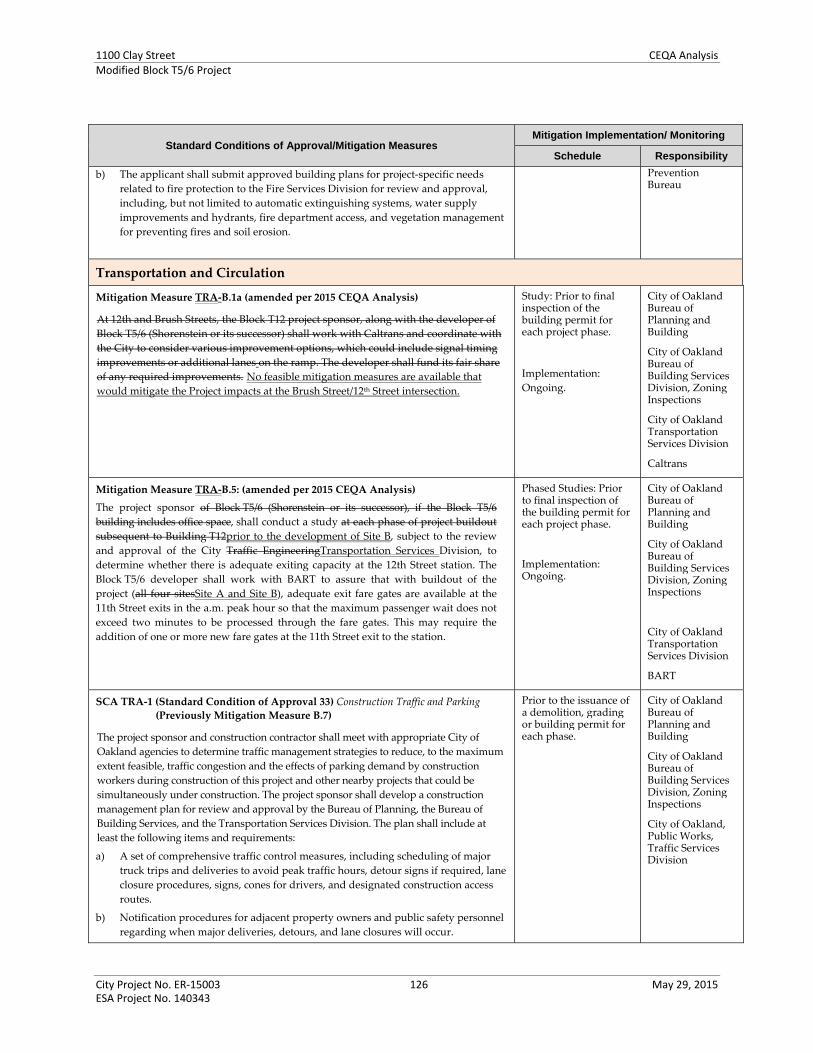
1100 Clay Street CEQA AnalysisModified Block T5/6 Project
City Project No. ER‐15003 126 May 29, 2015 ESA Project No. 140343
Standard Conditions of Approval/Mitigation Measures Mitigation Implementation/ Monitoring
Schedule Responsibility
b) The applicant shall submit approved building plans for project‐specific needs
related to fire protection to the Fire Services Division for review and approval,
including, but not limited to automatic extinguishing systems, water supply
improvements and hydrants, fire department access, and vegetation management
for preventing fires and soil erosion.
Prevention Bureau
Transportation and Circulation
Mitigation Measure TRA‐B.1a (amended per 2015 CEQA Analysis)
At 12th and Brush Streets, the Block T12 project sponsor, along with the developer of
Block T5/6 (Shorenstein or its successor) shall work with Caltrans and coordinate with
the City to consider various improvement options, which could include signal timing
improvements or additional lanes on the ramp. The developer shall fund its fair share
of any required improvements. No feasible mitigation measures are available that
would mitigate the Project impacts at the Brush Street/12th Street intersection.
Study: Prior to final inspection of the building permit for each project phase.
Implementation:
Ongoing.
City of Oakland Bureau of Planning and Building
City of Oakland Bureau of Building Services Division, Zoning Inspections
City of Oakland Transportation Services Division
Caltrans
Mitigation Measure TRA‐B.5: (amended per 2015 CEQA Analysis)
The project sponsor of Block T5/6 (Shorenstein or its successor), if the Block T5/6
building includes office space, shall conduct a study at each phase of project buildout
subsequent to Building T12prior to the development of Site B, subject to the review
and approval of the City Traffic EngineeringTransportation Services Division, to
determine whether there is adequate exiting capacity at the 12th Street station. The
Block T5/6 developer shall work with BART to assure that with buildout of the
project (all four sitesSite A and Site B), adequate exit fare gates are available at the
11th Street exits in the a.m. peak hour so that the maximum passenger wait does not
exceed two minutes to be processed through the fare gates. This may require the
addition of one or more new fare gates at the 11th Street exit to the station.
Phased Studies: Prior to final inspection of the building permit for each project phase.
Implementation: Ongoing.
City of Oakland Bureau of Planning and Building
City of Oakland Bureau of Building Services Division, Zoning Inspections
City of Oakland Transportation Services Division
BART
SCA TRA‐1 (Standard Condition of Approval 33) Construction Traffic and Parking
(Previously Mitigation Measure B.7)
The project sponsor and construction contractor shall meet with appropriate City of
Oakland agencies to determine traffic management strategies to reduce, to the maximum
extent feasible, traffic congestion and the effects of parking demand by construction
workers during construction of this project and other nearby projects that could be
simultaneously under construction. The project sponsor shall develop a construction
management plan for review and approval by the Bureau of Planning, the Bureau of
Building Services, and the Transportation Services Division. The plan shall include at
least the following items and requirements:
a) A set of comprehensive traffic control measures, including scheduling of major
truck trips and deliveries to avoid peak traffic hours, detour signs if required, lane
closure procedures, signs, cones for drivers, and designated construction access
routes.
b) Notification procedures for adjacent property owners and public safety personnel
regarding when major deliveries, detours, and lane closures will occur.
Prior to the issuance of a demolition, grading or building permit for each phase.
City of Oakland Bureau of Planning and Building
City of Oakland Bureau of Building Services Division, Zoning Inspections
City of Oakland, Public Works, Traffic Services Division

1100 Clay Street CEQA AnalysisModified Block T5/6 Project
City Project No. ER‐15003 127 May 29, 2015 ESA Project No. 140343
Standard Conditions of Approval/Mitigation Measures Mitigation Implementation/ Monitoring
Schedule Responsibility
c) Location of construction staging areas for materials, equipment, and vehicles at an
approved location.
d) A process for responding to, and tracking, complaints pertaining to construction
activity, including identification of an onsite complaint manager. The manager
shall determine the cause of the complaints and shall take prompt action to correct
the problem. The Bureau of Planning shall be informed who the Manager is prior
to the issuance of the first permit issued by Building Services.
e) Provision for accommodation of pedestrian flow.
f) Provision for parking management and spaces for all construction workers to
ensure that construction workers do not park in on‐street spaces.
g) Any damage to the street caused by heavy equipment, or as a result of this
construction, shall be repaired, at the project sponsor’s expense, within one week
of the occurrence of the damage (or excessive wear), unless further
damage/excessive wear may continue; in such case, repair shall occur prior to
issuance of a final inspection of the building permit. All damage that is a threat to
public health or safety shall be repaired immediately. The street shall be restored
to its condition prior to the new construction as established by the City Building
Inspector and/or photo documentation, at the project sponsor’s expense, before
the issuance of a Certificate of Occupancy.
h) Any heavy equipment brought to the construction site shall be transported by
truck, where feasible.
i) No materials or equipment shall be stored on the traveled roadway at any time.
j) Prior to construction, a portable toilet facility and a debris box shall be installed on
the site, and properly maintained through project completion.
k) All equipment shall be equipped with mufflers.
l) Prior to the end of each work day during construction, the contractor or
contractors shall pick up and properly dispose of all litter resulting from or
related to the project, whether located on the property, within the public rights‐of‐
way, or properties of adjacent or nearby neighbors.
Also SCAs AES‐7 and AES‐8. See Aesthetics, above.
Also SCA AIR‐2. See Air Quality, above.
Utilities and Service Systems
SCA UTIL‐1 (Standard Condition of Approval 91): Stormwater and Sewer
Confirmation of the capacity of the City’s surrounding stormwater and sanitary sewer
system and state of repair shall be completed by a qualified civil engineer with funding
from the project applicant. The project applicant shall be responsible for the necessary
stormwater and sanitary sewer infrastructure improvements to accommodate the
proposed project. In addition, the applicant shall be required to pay additional fees to
improve sanitary sewer infrastructure if required by the Sewer and Stormwater
Division. Improvements to the existing sanitary sewer collection system shall
specifically include, but are not limited to, mechanisms to control or minimize
increases in infiltration/inflow to offset sanitary sewer increases associated with the
proposed project. To the maximum extent practicable, the applicant will be required to
implement Best Management Practices to reduce the peak stormwater runoff from the
project site. Additionally, the project applicant shall be responsible for payment of the
required installation or hook‐up fees to the affected service providers.
Prior to issuance of a demolition, grading, or building permit within vicinity of the creek.
City of Oakland Bureau of Planning and Building
City of Oakland Bureau of Building Services Division, Zoning Inspections
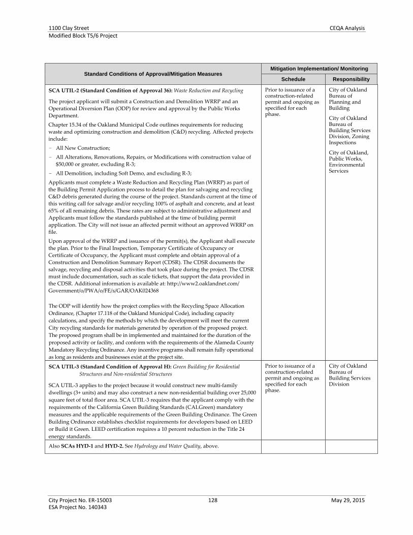
1100 Clay Street CEQA AnalysisModified Block T5/6 Project
City Project No. ER‐15003 128 May 29, 2015 ESA Project No. 140343
Standard Conditions of Approval/Mitigation Measures Mitigation Implementation/ Monitoring
Schedule Responsibility
SCA UTIL‐2 (Standard Condition of Approval 36): Waste Reduction and Recycling
The project applicant will submit a Construction and Demolition WRRP and an
Operational Diversion Plan (ODP) for review and approval by the Public Works
Department.
Chapter 15.34 of the Oakland Municipal Code outlines requirements for reducing
waste and optimizing construction and demolition (C&D) recycling. Affected projects
include:
- All New Construction;
- All Alterations, Renovations, Repairs, or Modifications with construction value of
$50,000 or greater, excluding R‐3;
- All Demolition, including Soft Demo, and excluding R‐3;
Applicants must complete a Waste Reduction and Recycling Plan (WRRP) as part of
the Building Permit Application process to detail the plan for salvaging and recycling
C&D debris generated during the course of the project. Standards current at the time of
this writing call for salvage and/or recycling 100% of asphalt and concrete, and at least
65% of all remaining debris. These rates are subject to administrative adjustment and
Applicants must follow the standards published at the time of building permit
application. The City will not issue an affected permit without an approved WRRP on
file.
Upon approval of the WRRP and issuance of the permit(s), the Applicant shall execute
the plan. Prior to the Final Inspection, Temporary Certificate of Occupancy or
Certificate of Occupancy, the Applicant must complete and obtain approval of a
Construction and Demolition Summary Report (CDSR). The CDSR documents the
salvage, recycling and disposal activities that took place during the project. The CDSR
must include documentation, such as scale tickets, that support the data provided in
the CDSR. Additional information is available at: http://www2.oaklandnet.com/
Government/o/PWA/o/FE/s/GAR/OAK024368
The ODP will identify how the project complies with the Recycling Space Allocation
Ordinance, (Chapter 17.118 of the Oakland Municipal Code), including capacity
calculations, and specify the methods by which the development will meet the current
City recycling standards for materials generated by operation of the proposed project.
The proposed program shall be in implemented and maintained for the duration of the
proposed activity or facility, and conform with the requirements of the Alameda County
Mandatory Recycling Ordinance. Any incentive programs shall remain fully operational
as long as residents and businesses exist at the project site.
Prior to issuance of a construction‐related permit and ongoing as specified for each phase.
City of Oakland Bureau of Planning and Building
City of Oakland Bureau of Building Services Division, Zoning Inspections
City of Oakland, Public Works, Environmental Services
SCA UTIL‐3 (Standard Condition of Approval H): Green Building for Residential
Structures and Non‐residential Structures
SCA UTIL‐3 applies to the project because it would construct new multi‐family
dwellings (3+ units) and may also construct a new non‐residential building over 25,000
square feet of total floor area. SCA UTIL‐3 requires that the applicant comply with the
requirements of the California Green Building Standards (CALGreen) mandatory
measures and the applicable requirements of the Green Building Ordinance. The Green
Building Ordinance establishes checklist requirements for developers based on LEED
or Build it Green. LEED certification requires a 10 percent reduction in the Title 24
energy standards.
Prior to issuance of a construction‐related permit and ongoing as specified for each phase.
City of Oakland Bureau of Building Services Division
Also SCAs HYD‐1 and HYD‐2. See Hydrology and Water Quality, above.
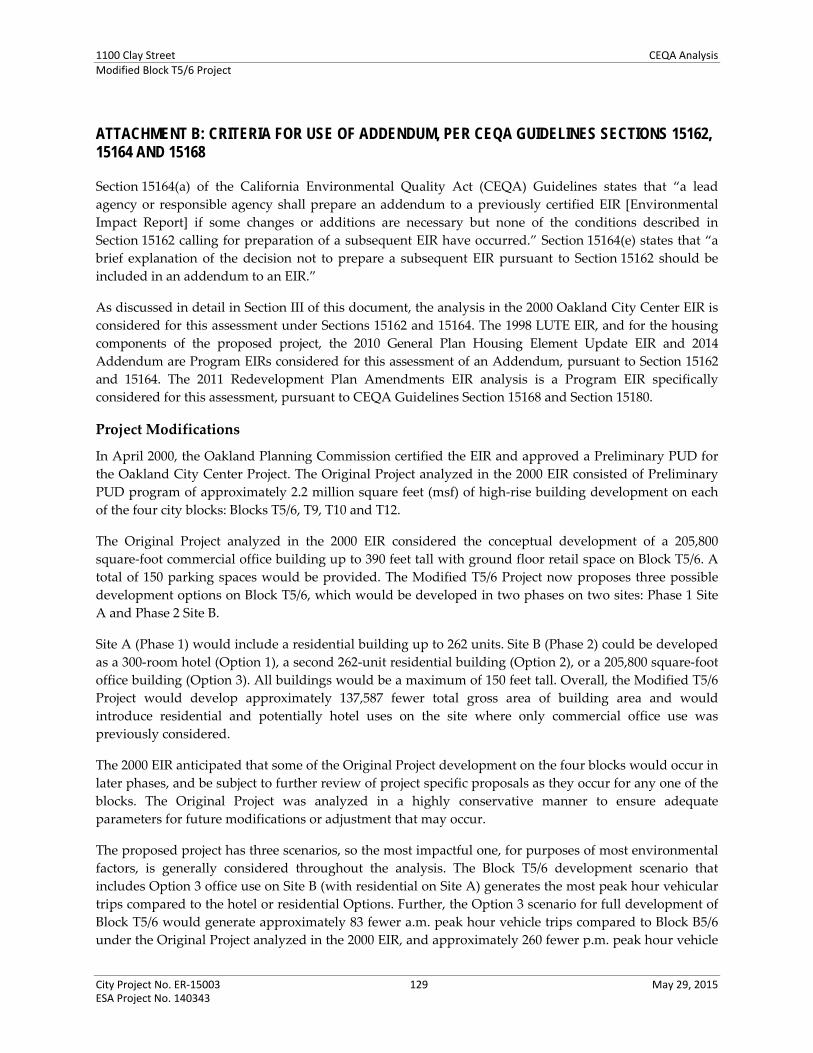
1100 Clay Street CEQA AnalysisModified Block T5/6 Project
City Project No. ER‐15003 129 May 29, 2015 ESA Project No. 140343
ATTACHMENT B: CRITERIA FOR USE OF ADDENDUM, PER CEQA GUIDELINES SECTIONS 15162, 15164 AND 15168
Section 15164(a) of the California Environmental Quality Act (CEQA) Guidelines states that “a lead
agency or responsible agency shall prepare an addendum to a previously certified EIR [Environmental
Impact Report] if some changes or additions are necessary but none of the conditions described in
Section 15162 calling for preparation of a subsequent EIR have occurred.” Section 15164(e) states that “a
brief explanation of the decision not to prepare a subsequent EIR pursuant to Section 15162 should be
included in an addendum to an EIR.”
As discussed in detail in Section III of this document, the analysis in the 2000 Oakland City Center EIR is
considered for this assessment under Sections 15162 and 15164. The 1998 LUTE EIR, and for the housing
components of the proposed project, the 2010 General Plan Housing Element Update EIR and 2014
Addendum are Program EIRs considered for this assessment of an Addendum, pursuant to Section 15162
and 15164. The 2011 Redevelopment Plan Amendments EIR analysis is a Program EIR specifically
considered for this assessment, pursuant to CEQA Guidelines Section 15168 and Section 15180.
Project Modifications
In April 2000, the Oakland Planning Commission certified the EIR and approved a Preliminary PUD for
the Oakland City Center Project. The Original Project analyzed in the 2000 EIR consisted of Preliminary
PUD program of approximately 2.2 million square feet (msf) of high‐rise building development on each
of the four city blocks: Blocks T5/6, T9, T10 and T12.
The Original Project analyzed in the 2000 EIR considered the conceptual development of a 205,800
square‐foot commercial office building up to 390 feet tall with ground floor retail space on Block T5/6. A
total of 150 parking spaces would be provided. The Modified T5/6 Project now proposes three possible
development options on Block T5/6, which would be developed in two phases on two sites: Phase 1 Site
A and Phase 2 Site B.
Site A (Phase 1) would include a residential building up to 262 units. Site B (Phase 2) could be developed
as a 300‐room hotel (Option 1), a second 262‐unit residential building (Option 2), or a 205,800 square‐foot
office building (Option 3). All buildings would be a maximum of 150 feet tall. Overall, the Modified T5/6
Project would develop approximately 137,587 fewer total gross area of building area and would
introduce residential and potentially hotel uses on the site where only commercial office use was
previously considered.
The 2000 EIR anticipated that some of the Original Project development on the four blocks would occur in
later phases, and be subject to further review of project specific proposals as they occur for any one of the
blocks. The Original Project was analyzed in a highly conservative manner to ensure adequate
parameters for future modifications or adjustment that may occur.
The proposed project has three scenarios, so the most impactful one, for purposes of most environmental
factors, is generally considered throughout the analysis. The Block T5/6 development scenario that
includes Option 3 office use on Site B (with residential on Site A) generates the most peak hour vehicular
trips compared to the hotel or residential Options. Further, the Option 3 scenario for full development of
Block T5/6 would generate approximately 83 fewer a.m. peak hour vehicle trips compared to Block B5/6
under the Original Project analyzed in the 2000 EIR, and approximately 260 fewer p.m. peak hour vehicle

1100 Clay Street CEQA AnalysisModified Block T5/6 Project
City Project No. ER‐15003 130 May 29, 2015 ESA Project No. 140343
trips. Overall, compared to the Original Project for Block T5/6, the proposed project would introduce
different or additional land uses on the site, and would result in less overall development that previously
analyzed. The proposed project would represent a minor change in the Original Project, and such
changes were anticipated in the 2000 EIR.
Conditions for Addendum
None of the following conditions for preparation of a subsequent EIR per Sections 15162(a) and 15168
apply to the proposed project:
(1) Substantial changes are proposed in the project which will require major revisions of the previous
EIR or negative declaration due to the involvement of new significant environmental effects or a
substantial increase in the severity of previously identified significant effects;
(2) Substantial changes occur with respect to the circumstances under which the project is undertaken
which will require major revisions of the previous EIR or Negative Declaration due to the
involvement of new significant environmental effects or a substantial increase in the severity of
previously identified significant effects; or
(3) New information of substantial importance, which was not known and could not have been known
with the exercise of reasonable diligence at the time the previous EIR was certified as complete or
the Negative Declaration was adopted, shows any of the following:
(A) The project will have one or more significant effects not discussed in the previous EIR or
negative declaration;
(B) Significant effects previously examined will be substantially more severe than shown in the
previous EIR;
(C) Mitigation measures or alternatives previously found not to be feasible would in fact be
feasible, and would substantially reduce one or more significant effects of the project, but
the project proponents decline to adopt the mitigation measure or alternative; or Mitigation
measures or alternatives which are considerably different from those analyzed in the
previous EIR would substantially reduce one or more significant effects on the
environment, but the project proponents decline to adopt the mitigation measure or
alternative.
Project Consistency with Sections 15162 and 15168 of the CEQA Guidelines
Since certification of the 2000 EIR, including its subsequent addenda, no changes have occurred in the
circumstances under which the proposed project would be implemented, that would change the severity
of the proposed project’s physical impacts, as explained in the CEQA Checklist in Section VI of this
document. No new information has emerged that would materially change the analyses or conclusions
set forth in the Final EIR.
Furthermore, as demonstrated in the CEQA Checklist, the proposed project would not result in any new
significant environmental impacts, result in any substantial increases in the significance of previously
identified effects, or necessitate implementation of additional or considerably different mitigation
measures than those identified in the 2000 EIR, nor render any mitigation measures or alternatives found
not to be feasible, feasible. The effects of the proposed project would be substantially the same as those

1100 Clay Street CEQA AnalysisModified Block T5/6 Project
City Project No. ER‐15003 131 May 29, 2015 ESA Project No. 140343
reported in the 2000 EIR. The proposed project would result in a significant and unavoidable impact that
was previously identified in the 2000 EIR.
The analysis presented in this CEQA Checklist, combined with the prior 2000 EIR analysis, demonstrates
that the proposed project would not result in significant impacts that were not previously identified in
the EIR. The proposed project would not result in a substantial increase in the significance of impacts, nor
would the proposed project contribute considerably to cumulative effects that were not already
accounted for in the certified 2000 EIR. Overall, the proposed project’s impacts are similar to those
identified and discussed in the 2000 EIR, as described in the CEQA Checklist, and the findings reached in
the EIR are applicable.
_____________________________

1100 Clay Street CEQA AnalysisModified Block T5/6 Project
City Project No. ER‐15003 132 May 29, 2015 ESA Project No. 140343
ATTACHMENT C: PROJECT CONSISTENCY WITH COMMUNITY PLAN OR ZONING, PER CEQA GUIDELINES SECTION 15183
Section 15183(a) of the California Environmental Quality Act (CEQA) Guidelines states that “…projects
which are consistent with the development density established by the existing zoning, community plan,
or general plan policies for which an Environmental Impact Report (EIR) was certified shall not require
additional environmental review, except as may be necessary to examine whether there are project‐
specific significant effects which are peculiar to the project or its site.”
As discussed in detail in Section III of this document, the analysis in the 1998 LUTE EIR and, for only the
residential components of the proposed project, the 2010 Housing Element Update EIR and its 2014
Addendum, are considered the qualified planning level CEQA documents for this assessment, pursuant
to CEQA Guidelines Section 15183.Proposed Project
The proposed project would be located in developed urbanized Downtown Oakland. The proposed
project would be developed in two phases. Phase 1 would construct a new, 262‐unit residential building,
and Phase 2, which would occur at a later date, could develop as a 300‐key hotel, a second residential
building of up to 262 units, or a 205,800 square‐foot office building. The buildings would be up to 150 feet
tall; parking would be provided onsite or in an adjacent parking structure, and small local‐serving
commercial uses ‐ such as a small restaurant or retail space would occur at the street level. The proposed
project could also develop a new pedestrian plaza and parking accessible by the public. No buildings
existing on the project site; the project will remove existing lawn and mature trees, as well as an existing
driveway between the City Center Garage and Clay Street.
Project Consistency
As determined by the City of Oakland Bureau of Planning, the proposed land uses are permitted in the
zoning district in which the project is located, and is consistent with the bulk, density, and land uses
envisioned for Block T5/6 and in Downtown Oakland, as outlined below.
The General Plan land use designation for the site is Central Business District (CBD). This
designation applies to areas suitable for high density mixed use urban center with a mix of large‐
scale offices, commercial, urban (high‐rise) residential, and infill hotel uses, among many others, in
the central Downtown core of the city. The proposed residential mixed use project would be
consistent with this designation.
The site is zoned Central Business District Central Commercial Zone (CBD‐C). The proposed
project would be consistent with the purposes of this district, which is generally intended to create,
maintain, and enhance areas of the CBD appropriate for a wide range of ground‐floor office and
other commercial activities. Upper‐story spaces are intended to be available for a wide range of
residential and office or other commercial activities. The proposed project would develop ground‐
floor commercial retail/restaurant space with upper level residential, office, or hotel use.
The proposed project would develop buildings up to 150 feet in height, with a two‐level base of
approximately 57 feet. This would be in compliance with the height limits for the site, which are a
minimum 45 feet and maximum 85 feet for the height of the building base, and no height limit
above the base.
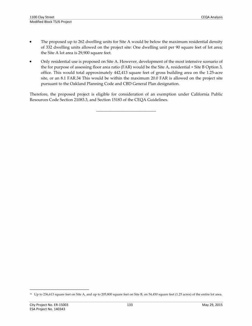
1100 Clay Street CEQA AnalysisModified Block T5/6 Project
City Project No. ER‐15003 133 May 29, 2015 ESA Project No. 140343
The proposed up to 262 dwelling units for Site A would be below the maximum residential density
of 332 dwelling units allowed on the project site: One dwelling unit per 90 square feet of lot area;
the Site A lot area is 29,900 square feet.
Only residential use is proposed on Site A. However, development of the most intensive scenario of
the for purpose of assessing floor area ratio (FAR) would be the Site A, residential + Site B Option 3,
office. This would total approximately 442,413 square feet of gross building area on the 1.25‐acre
site, or an 8.1 FAR.34 This would be within the maximum 20.0 FAR is allowed on the project site
pursuant to the Oakland Planning Code and CBD General Plan designation.
Therefore, the proposed project is eligible for consideration of an exemption under California Public
Resources Code Section 21083.3, and Section 15183 of the CEQA Guidelines.
_____________________________
34 Up to 236,613 square feet on Site A, and up to 205,800 square feet on Site B, on 54,450 square feet (1.25 acres) of the entire lot area.

1100 Clay Street CEQA AnalysisModified Block T5/6 Project
City Project No. ER‐15003 134 May 29, 2015 ESA Project No. 140343
ATTACHMENT D: INFILL PERFORMANCE STANDARDS, PER CEQA GUIDELINES SECTION 15183.3
California Environmental Quality Act (CEQA) Guidelines Section 15183.3(b) and CEQA Guidelines
Appendix M establish eligibility requirements for projects to qualify as infill projects. Table D‐1, below,
shows how the proposed project satisfies each of the applicable requirements.
As discussed in detail in Section III of this document, the analysis in the 1998 LUTE EIR and, for only the
residential components of the proposed project, the 2010 Housing Element Update EIR and its 2014
Addendum, are considered the Program EIRs for this assessment, pursuant to CEQA Guidelines Section
15183.3.
Table D‐1
Project Infill Eligibility
CEQA Eligibility Criteria Eligible?/Notes for Proposed Project
1. Be located in an urban area on a site that either
has been previously developed or that adjoins
existing qualified urban uses on at least seventy‐
five percent of the site’s perimeter. For the
purpose of this subdivision “adjoin” means the
infill project is immediately adjacent to qualified
urban uses or is only separated from such uses by
an improved right‐of‐way. (CEQA Guidelines
Section 15183.3[b][1])
Yes.
The project site has been previously developed as a
service station, with various surrounding uses,
including parking lots and garages, gas stations, and
commercial service uses.; it adjoins existing urban uses,
including high‐and mid‐rise commercial office
buildings, as described in the Project Description,
(Section IV).
2. Satisfy the performance Standards provided in
Appendix M (CEQA Guidelines
Section 15183.3[b][2]) as presented in 2a and 2b
below:
—
2a. Performance Standards Related to Project Design.
All projects must implement all of the following:
—
Renewable Energy.
Non‐Residential Projects. All nonresidential projects
shall include onsite renewable power generation,
such as solar photovoltaic, solar thermal, and
wind power generation, or clean back‐up power
supplies, where feasible.
Residential Projects. Residential projects are also
encouraged to include such on site renewable
power generation.
Yes.
According to Section IV (G) of CEQA Appendix M, for
mixed‐use projects “…the performance standards in
this section that apply to the predominant use shall
govern the entire project.” If Phase 2 Site B of the
project is developed with the hotel or commercial office
use, the project will be mixed use with an even portion
of the site used as residential use (Phase 1 Site A) and
one of the aforementioned non‐residential uses. The
project sponsor shall prepare, for City review and
approval, a feasibility assessment of onsite renewable
power generation options. If determined feasible by the
City, the project sponsor shall implement onsite
renewable power generation. Also, the proposed
project has indicated a LEED silver standard goal, and
its initial LEED Score Card indicates points for
optimizing energy performance.

1100 Clay Street CEQA AnalysisModified Block T5/6 Project
City Project No. ER‐15003 135 May 29, 2015 ESA Project No. 140343
Table D‐1
Project Infill Eligibility
CEQA Eligibility Criteria Eligible?/Notes for Proposed Project
Soil and Water Remediation.
If the project site is included on any list compiled
pursuant to Section 65962.5 of the Government
Code, the project shall document how it has
remediated the site, if remediation is completed.
Alternatively, the project shall implement the
recommendations provided in a preliminary
endangerment assessment or comparable
document that identifies remediation appropriate
for the site.
The project will complete all remaining remediation
required for the uses proposed on the project site.
Several past environmental investigations conducted
on the project characterized soil and groundwater
impacts from the historic release of petroleum
hydrocarbons. Site B was granted regulatory closure by
Alameda County in 2001; no regulatory closure letters
have been located for Site A. Pursuant to the
recommendations in the Phase 1 environmental site
assessment prepared for the project site (Langan
Treadwell Rollo, 2015), the project sponsor will
undertake all additional soil and groundwater
characterization prior to site development.
Residential Units Near High‐Volume Roadways
and Stationary Sources.
If a project includes residential units located
within 500 feet, or other distance determined to be
appropriate by the local agency or air district
based on local conditions, of a high volume
roadway or other significant sources of air
pollution, the project shall comply with any
policies and standards identified in the local
general plan, specific plan, zoning code, or
community risk reduction plan for the protection
of public health from such sources of air pollution.
If the local government has not adopted such
plans or policies, the project shall include
measures, such as enhanced air filtration and
project design, that the lead agency finds, based
on substantial evidence, will promote the
protection of public health from sources of air
pollution. Those measures may include, among
others, the recommendations of the California Air
Resources Board, air districts, and the California
Air Pollution Control Officers Association.
Yes.
As discussed in Section 2. Air Quality of the CEQA
Checklist, an air quality screening was prepared for the
proposed project.
According to BAAQMD’s conservative screening‐level
tool for Alameda County, there are 15 stationary TAC
sources within 1,000 feet of the Block T5/6, all of which
are backup generators. Factoring in allowable
refinements to these the screening values to account for
distance between Block T5/6 and the nearby stationary
TAC sources and considering risks posed by roadway
traffic on Broadway and the proposed project’s backup
diesel generators, the cumulative cancer risks at the
project site would be below the significance criterion of
100 in one million. Therefore a health risk was neither
required nor conducted. No air pollution standards are
required to be implemented for the proposed project.
The nearest “high‐volume roadway” with 100,000
vehicles per day, as defined by Section II of CEQA
Appendix M, is Interstate 980 (I‐980). I‐980 is
approximately 1,250 feet from the project site.
2b. Additional Performance Standards by Project Type.
In addition to implementing all the features
described in 2a above, the project must meet
eligibility requirements provided below by project
type.
Residential. A residential project must meet one
of the following:
A. Projects achieving below average regional per capita
vehicle miles traveled (VMT). A residential project is
Yes.
The proposed project is eligible under Section (B). The
proposed project site is well‐served by multiple transit
providers. Transit service providers in the project

1100 Clay Street CEQA AnalysisModified Block T5/6 Project
City Project No. ER‐15003 136 May 29, 2015 ESA Project No. 140343
Table D‐1
Project Infill Eligibility
CEQA Eligibility Criteria Eligible?/Notes for Proposed Project
eligible if it is located in a “low vehicle travel
area” within the region;
B. Projects located within ½ mile of an Existing Major
Transit Stop or High Quality Transit Corridor. A
residential project is eligible if it is located within
½ mile of an existing major transit stop or an
existing stop along a high quality transit corridor; or
C. Low ‐ Income Housing. A residential or mixed‐
use project consisting of 300 or fewer residential
units all of which are affordable to low income
households is eligible if the developer of the
development project provides sufficient legal
commitments to the lead agency to ensure the
continued availability and use of the housing
units for lower income households, as defined in
Section 50079.5 of the Health and Safety Code, for
a period of at least 30 years, at monthly housing
costs, as determined pursuant to Section 50053 of
the Health and Safety Code.
vicinity include Bay Area Rapid Transit (BART) and
AC Transit. The nearest BART station to project site is
the 12th Street BART Station, about one block east. AC
Transit operates multiple major bus routes in the
vicinity of the project, on 11th Street, 12th Street, and
Clay Street. Additional buses, including the Oakland
Free Broadway shuttle (“Free B”), operate along
Broadway with the nearest stops near 11th and 12th
Streets, about 650 feet east of the Site A building. The
transbay ferry from Jack London Square is
approximately 0.75 miles south.
Broadway – up to two blocks east of the project site ‐
qualifies as a “High Quality Transit Corridor,” as
defined by Section II of CEQA, with fixed route bus
service at intervals no longer than 15 minutes during
peak commute hours. The AC Transit Line 51A runs
along Broadway in the project vicinity, and has service
intervals no longer than 15 minutes during peak
commute hours. Other bus routes in the project vicinity
further satisfy this criterion.
Commercial/Retail. A commercial/retail project
must meet one of the following:
A. Regional Location. A commercial project with no
single‐building floor‐plate greater than
50,000 square feet is eligible if it locates in a “low
vehicle travel area”; or
B. Proximity to Households. A project with no
single‐building floor‐plate greater than
50,000 square feet located within ½ mile of 1,800
households is eligible.
Pending.
As previously discussed, according to Section IV (G) of
CEQA Appendix M, for mixed‐use projects “…the
performance standards in this Section that apply to the
predominant use shall govern the entire project.” If
Phase 2 Site B of the project is developed with the hotel
or commercial office use, the project would be mixed
use with an even portion of the site used as residential
use (Phase 1 Site A) and one of the aforementioned
non‐residential uses. Conservatively, in the latter case,
the commercial/retail building would be developed in
downtown in proximity to households, including the
newer and nearby Uptown project ( 1,270 units) ,
Landmark Place (92 units), Market Square Phase 1 (115
units), as well as other existing households within a
one‐half mile radius, generally I‐980 to I‐880 and Lake
Merritt to Grand Avenue.
Office Building. An office building project must
meeting one of the following:
A. Regional Location. Office buildings, both
commercial and public, are eligible if they locate
in a low vehicle travel area; or
B. Proximity to a Major Transit Stop. Office
buildings, both commercial and public, within
½ mile of an existing major transit stop, or ¼ mile
Yes.
If Phase 2 Site B of the project is developed with the
commercial office option, the office building would be
located approximately one block from the nearest
BART station entrance and multiple major bus routes,
as described previously in this table.
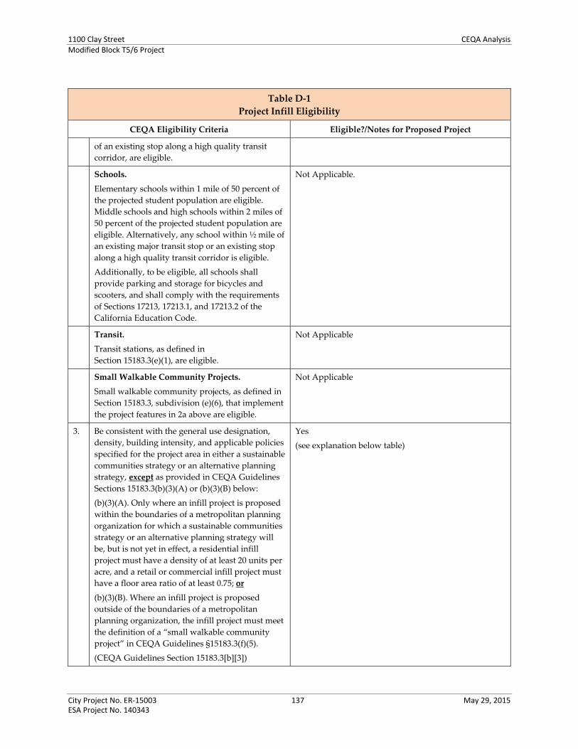
1100 Clay Street CEQA AnalysisModified Block T5/6 Project
City Project No. ER‐15003 137 May 29, 2015 ESA Project No. 140343
Table D‐1
Project Infill Eligibility
CEQA Eligibility Criteria Eligible?/Notes for Proposed Project
of an existing stop along a high quality transit
corridor, are eligible.
Schools.
Elementary schools within 1 mile of 50 percent of
the projected student population are eligible.
Middle schools and high schools within 2 miles of
50 percent of the projected student population are
eligible. Alternatively, any school within ½ mile of
an existing major transit stop or an existing stop
along a high quality transit corridor is eligible.
Additionally, to be eligible, all schools shall
provide parking and storage for bicycles and
scooters, and shall comply with the requirements
of Sections 17213, 17213.1, and 17213.2 of the
California Education Code.
Not Applicable.
Transit.
Transit stations, as defined in
Section 15183.3(e)(1), are eligible.
Not Applicable
Small Walkable Community Projects.
Small walkable community projects, as defined in
Section 15183.3, subdivision (e)(6), that implement
the project features in 2a above are eligible.
Not Applicable
3. Be consistent with the general use designation,
density, building intensity, and applicable policies
specified for the project area in either a sustainable
communities strategy or an alternative planning
strategy, except as provided in CEQA Guidelines
Sections 15183.3(b)(3)(A) or (b)(3)(B) below:
(b)(3)(A). Only where an infill project is proposed
within the boundaries of a metropolitan planning
organization for which a sustainable communities
strategy or an alternative planning strategy will
be, but is not yet in effect, a residential infill
project must have a density of at least 20 units per
acre, and a retail or commercial infill project must
have a floor area ratio of at least 0.75; or
(b)(3)(B). Where an infill project is proposed
outside of the boundaries of a metropolitan
planning organization, the infill project must meet
the definition of a “small walkable community
project” in CEQA Guidelines §15183.3(f)(5).
(CEQA Guidelines Section 15183.3[b][3])
Yes
(see explanation below table)

1100 Clay Street CEQA AnalysisModified Block T5/6 Project
City Project No. ER‐15003 138 May 29, 2015 ESA Project No. 140343
Table D‐1
Project Infill Eligibility
CEQA Eligibility Criteria Eligible?/Notes for Proposed Project
Note:
a Where a project includes some combination of residential, commercial and retail, office building, transit station, and/or
schools, the performance standards in this section that apply to the predominant use shall govern the entire project.
Explanation for Eligibility Criterion 3 (from Table D‐1 above)
The adopted Plan Bay Area (2013) serves as the sustainable communities strategy for the Bay Area, per
Senate Bill 375. As defined by the Plan, Priority Development Areas (PDAs) are areas where new
development will support the needs of residents and workers in a pedestrian‐friendly environment
served by transit. The Oakland City Center Project and Block T5/6 is considered within the “Oakland
Downtown & Jack London Square” PDA – the area bounded generally by 28th Street on the north, I‐980
on the west, the Oakland Estuary on the south, and Lake Merritt on the east, excepting the Chinatown
area between 6th and 11th Streets east of Franklin Street. The proposed project is consistent with the
Oakland General Plan and the Planning Code, as discussed in Attachment C.
The General Plan land use designation for the site is Central Business District (CBD). This
designation applies to areas suitable for high density mixed use urban center with a mix of large‐
scale offices, commercial, urban (high‐rise) residential, and infill hotel uses, among many others, in
the central Downtown core of the city. The proposed residential or residential‐commercial mixed
use project would be consistent with this designation.
The site is zoned Central Business District Central Commercial Zone (CBD‐C). The proposed
project would be consistent with the purposes of this district, which is generally intended to create,
maintain, and enhance areas of the CBD appropriate for a wide range of ground‐floor office and
other commercial activities. Upper‐story spaces are intended to be available for a wide range of
residential and office or other commercial activities. The proposed project would develop ground‐
floor commercial retail/restaurant space with upper level residential, office, or hotel use.
The proposed project would develop buildings up to 150 feet in height, with a two‐level base of
approximately 57 feet. This would be in compliance with the height limits for the site, which are a
minimum 45 feet and maximum 85 feet for the height of the building base, and no height limit
above the base.
The proposed up to 262 dwelling units for Site A would be below the maximum residential density
of 332 dwelling units allowed on the project site: One dwelling unit per 90 square feet of lot area;
the Site A lot area is 29,900 square feet.
Only residential use is proposed on Site A. However, development of the most intensive scenario of
the for purpose of assessing floor area ratio (FAR) would be the Site A, residential + Site B Option 3,
office. This would total approximately 442,413 square feet of gross building area on the 1.25‐acre
site, or an 8.1 FAR.35 This would be within the maximum 20.0 FAR is allowed on the project site
pursuant to the Oakland Planning Code and CBD General Plan designation.
35 Up to 236,613 square feet on Site A, and up to 205,800 square feet on Site B, on 54,450 square feet (1.25 acres) of the entire lot area.

1100 Clay Street CEQA AnalysisModified Block T5/6 Project
City Project No. ER‐15003 139 May 29, 2015 ESA Project No. 140343
VII. References (All references cited below are available at the Oakland Bureau of Planning, Agency, 250 Frank Ogawa
Plaza, Suite 3330, Oakland, California, unless specified otherwise.)
Oakland City Center Project
City of Oakland, Oakland City Center Project Draft Environmental Impact Report, January 31, 2000.
City of Oakland, Oakland City Center Project Final Environmental Impact Report, April 14, 2000.
City of Oakland, Oakland City Center Project Final Environmental Impact Report, Addendum #1, October 13, 2003.
City of Oakland, Oakland City Center Project Final Environmental Impact Report, Addendum #2, June 9, 2005.
City of Oakland, Oakland City Center Project Final Environmental Impact Report, Addendum #3, November 27, 2007.
City of Oakland, Oakland City Center Project Final Environmental Impact Report, Addendum #4, July 27, 2010.
Housing Element Update
City of Oakland, Draft EIR for the 2007‐2015 Housing Element Update, 2009.
City of Oakland, Final EIR for the 2007‐2015 Housing Element Update, 2010.
City of Oakland, 2015‐2023 Housing Element Addendum to the 2010 Housing Element EIR, 2014.
Central District Urban Renewal Plan Amendment (Redevelopment Plan)
Oakland Redevelopment Agency, Draft EIR for the Proposed Amendments to the Central District Urban Renewal Plan, March 2011.
Oakland Redevelopment Agency, Final EIR for the Proposed Amendments to the Central District Urban Renewal Plan, June 2011.
Oakland Redevelopment Agency, 2012. Central District Urban Renewal Plan, Adopted June 12. 1969, as amended through April 3, 2012.
General Plan Land Use and Transportation Element
City of Oakland, 1998 LUTE Draft EIR, [month] 1997.
City of Oakland, 1998 LUTE Final EIR, February 1998.
City of Oakland, 2007. Land Use and Transportation Element of the Oakland General Plan, March 24, 1998, amended to June 21, 2007.
1100 Clay Street CEQA AnalysisModified Block T5/6 Project
City Project No. ER‐15003 140 May 29, 2015 ESA Project No. 140343
Plan Bay Area
Metropolitan Transportation Commission and Association of Bay Area Governments, 2013. Plan Bay Area, Strategy for a Sustainable Region. Adopted July 18, 2013.
Oakland Planning Code
City of Oakland, 2013. City of Oakland Planning Code. CEDA: Planning and Zoning. http://www2.oaklandnet.com/oakca1/groups/ceda/documents/report/oak032032.pdf, accessed February 14, 2013.
City Center Modified Block T5/6 Technical Reports Langan Treadwell Rollo, Phase I Environmental Site Assessment, Oakland City Center 11th Street,
January 22, 2015.
Fehr & Peers, Oakland City Center Development (T5/6) – Transportation Impact Analysis, February 13, 2015
Langan Treadwell Rollo, Preliminary Geotechnical Evaluation, T5/6 Oakland City Center 11th Street, April 14, 2015.
Lea & Braze Engineering, Inc., Technical Memo: Stormwater Information for 1100 Clay Street, Site T5/6. April 16, 2015.
Lea & Braze Engineering, Inc., Technical Memo: Sewer and Water Demand Estimates, 1100 Clay Street, Site T5/6. (email) April 17, 2015.


APPENDIX A Reference Figures from Previous Aesthetics Analyses

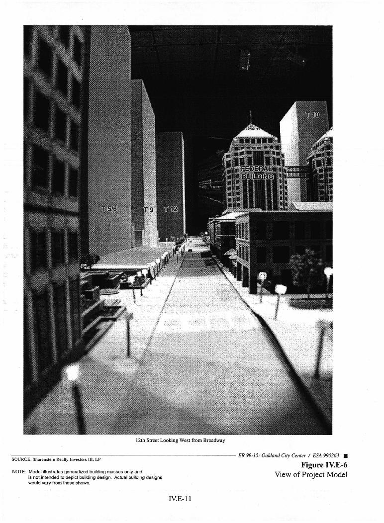
12th Street Looking West from Broadway
SOURCE: Shorenstein Realty Investors Ill, LP
NOTE: Model illustrates generalized building masses only and is not intended to depict building design. Actual building designs would vary from those shown.
IVE-ll
ER 99-15: Oaklalld City Cell1er / ESA 990263 •
Figure IV.E-6 View of Project Model

12th Street Looking East from 1/2 Block West of Jefferson
SOURCE: Shorenstein Realty Investors Ill. LP
NOTE: Model illustrates generalized building masses only and is not intended to depict building design. Actual building designs would vary from those shown.
IV.E-12
ER 99-15: Oakland City Cellter I ESA 990263 •
Figure IV.E-7 View of Project Model
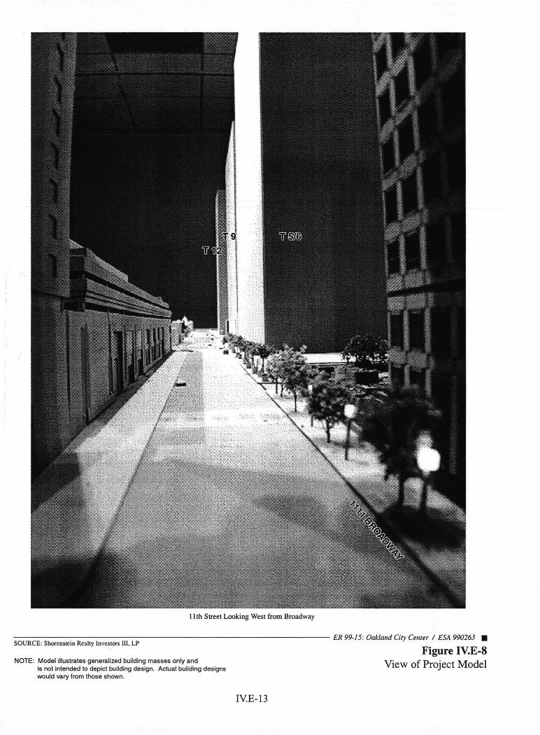
11 th Street Looking West from Broadway
~S-;::O;U~R;-;:C:;;E~: ~Sh;::o:re=n::::st:ei=n-;;R;::e::;al:tY:-;I-=-n\:::'e=st:-:-o=rs-:-ll::-I.-:L-:-P:---------------------- ER 99-/5: Oakland City Center I ESA 990263 •
Figure IV.E-8 View of Project Model NOTE: Model illustrates generalized building masses only and
is not intended to depict building design. Actual building designs would vary from those shown.
IV.E-13
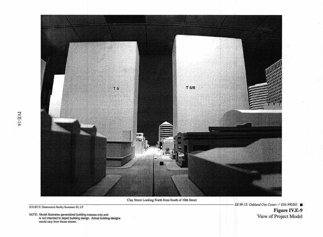
;2 tTl I -~
SOURCE: Shorenstein Realty Investors III, LP
NOTE: Model illustrates generalized building masses only and is not intended to depict building design. Actual building designs would vary from those shown.
Clay Street Looking North from South of 10th Street
ER 99-15: Oaklalld City CellIer / ESA 990263 •
Figure IV.E-9 View of Project Model

Looking North along MLK Jr. Way from South of 10th Street
;SO~U-;;-R;::C~E~: S;:-;h=o-=re=n=ste-:-:i=-n::R=-ea:::lt:::y-:ln-v-:-es=to-r-S::n-=-I,-:-L-=P--------------------- ER 99-15: Oaklalld City Cellter / ESA 990263 •
NOTE: Model illustrates generalized building masses only and is not intended to depict building design. Actual building designs would vary from those shown.
IY.E-15
Figure IV.E-IO View of Project Model


14TH ST14TH ST
MA
RTI
N L
UTH
ER
KIN
G J
R. W
AYM
AR
TIN
LU
THE
R K
ING
JR
. WAY
CA
STR
O S
TC
AS
TRO
ST
CLA
Y S
TC
LAY
ST
BR
OA
DW
AYB
RO
AD
WAY
JEFF
ER
SO
N S
TJE
FFE
RS
ON
ST
12TH ST12TH ST
11TH ST11TH ST
10TH ST10TH ST
Block T10 (u.c.)Block T10 (u.c.)
Block T5/T6Block T5/T6(approved)(approved)Block T9Block T9
Block T12Block T12PardeePardeeHome &Home &GardensGardens
LafayetteLafayetteSquareSquare
ParkPark
Federal BuildingFederal Building City WalkCity WalkPreservation ParkPreservation Park
14TH ST
MA
RTI
N L
UTH
ER
KIN
G J
R. W
AY
CA
STR
O S
T
CLA
Y S
T
BR
OA
DW
AY
JEFF
ER
SO
N S
T
12TH ST
11TH ST
10TH ST
Block T10 (u.c.)
Block T5/T6(approved)Block T9
Block T12PardeeHome &Gardens
LafayetteSquare
Park
Federal Building City WalkPreservation Park
T12SITE
T12SITE
Figure 3Project Shadow Patterns
June and December, 9:00 am
SOURCE: Korth Sunseri Hagey ArchitectsCity Center EIR Addendum #3 . ESA 207453

14TH ST14TH ST
MA
RTI
N L
UTH
ER
KIN
G J
R. W
AYM
AR
TIN
LU
THE
R K
ING
JR
. WAY
CA
STR
O S
TC
AS
TRO
ST
CLA
Y S
TC
LAY
ST
BR
OA
DW
AYB
RO
AD
WAY
JEFF
ER
SO
N S
TJE
FFE
RS
ON
ST
12TH ST12TH ST
11TH ST11TH ST
10TH ST10TH ST
Block T10 (u.c.)Block T10 (u.c.)
Block T5/T6Block T5/T6(approved)(approved)Block T9Block T9
Block T12Block T12PardeePardeeHome &Home &GardensGardens
LafayetteLafayetteSquareSquare
ParkPark
Federal BuildingFederal Building City WalkCity WalkPreservation ParkPreservation Park
14TH ST
MA
RTI
N L
UTH
ER
KIN
G J
R. W
AY
CA
STR
O S
T
CLA
Y S
T
BR
OA
DW
AY
JEFF
ER
SO
N S
T
12TH ST
11TH ST
10TH ST
Block T10 (u.c.)
Block T5/T6(approved)Block T9
Block T12PardeeHome &Gardens
LafayetteSquare
Park
Federal Building City WalkPreservation Park
T12SITE
T12SITE
14TH ST14TH ST
MA
RTI
N L
UTH
ER
KIN
G J
R. W
AYM
AR
TIN
LU
THE
R K
ING
JR
. WAY
CA
STR
O S
TC
AS
TRO
ST
CLA
Y S
TC
LAY
ST
BR
OA
DW
AYB
RO
AD
WAY
JEFF
ER
SO
N S
TJE
FFE
RS
ON
ST
12TH ST12TH ST
11TH ST11TH ST
10TH ST10TH ST
Block T10 (u.c.)Block T10 (u.c.)
Block T5/T6Block T5/T6(approved)(approved)Block T9Block T9
Block T12Block T12PardeePardeeHome &Home &GardensGardens
LafayetteLafayetteSquareSquare
ParkPark
Federal BuildingFederal Building City WalkCity WalkPreservation ParkPreservation Park
14TH ST
MA
RTI
N L
UTH
ER
KIN
G J
R. W
AY
CA
STR
O S
T
CLA
Y S
T
BR
OA
DW
AY
JEFF
ER
SO
N S
T
12TH ST
11TH ST
10TH ST
Block T10 (u.c.)
Block T5/T6(approved)Block T9
Block T12PardeeHome &Gardens
LafayetteSquare
Park
Federal Building City WalkPreservation Park
T12SITE
T12SITE
Figure 4Project Shadow Patterns
June and December, Noon
SOURCE: Korth Sunseri Hagey ArchitectsCity Center EIR Addendum #3 . ESA 207453

14TH ST14TH ST
MA
RTI
N L
UTH
ER
KIN
G J
R. W
AYM
AR
TIN
LU
THE
R K
ING
JR
. WAY
CA
STR
O S
TC
AS
TRO
ST
CLA
Y S
TC
LAY
ST
BR
OA
DW
AYB
RO
AD
WAY
JEFF
ER
SO
N S
TJE
FFE
RS
ON
ST
12TH ST12TH ST
11TH ST11TH ST
10TH ST10TH ST
Block T10 (u.c.)Block T10 (u.c.)
Block T5/T6Block T5/T6(approved)(approved)Block T9Block T9
Block T12Block T12PardeePardeeHome &Home &GardensGardens
LafayetteLafayetteSquareSquare
ParkPark
Federal BuildingFederal Building City WalkCity WalkPreservation ParkPreservation Park
14TH ST
MA
RTI
N L
UTH
ER
KIN
G J
R. W
AY
CA
STR
O S
T
CLA
Y S
T
BR
OA
DW
AY
JEFF
ER
SO
N S
T
12TH ST
11TH ST
10TH ST
Block T10 (u.c.)
Block T5/T6(approved)Block T9
Block T12PardeeHome &Gardens
LafayetteSquare
Park
Federal Building City WalkPreservation Park
14TH ST14TH ST
MA
RTI
N L
UTH
ER
KIN
G J
R. W
AYM
AR
TIN
LU
THE
R K
ING
JR
. WAY
CA
STR
O S
TC
AS
TRO
ST
CLA
Y S
TC
LAY
ST
BR
OA
DW
AYB
RO
AD
WAY
JEFF
ER
SO
N S
TJE
FFE
RS
ON
ST
12TH ST12TH ST
11TH ST11TH ST
10TH ST10TH ST
Block T10 (u.c.)Block T10 (u.c.)
Block T5/T6Block T5/T6(approved)(approved)Block T9Block T9
Block T12Block T12PardeePardeeHome &Home &GardensGardens
LafayetteLafayetteSquareSquare
ParkPark
Federal BuildingFederal Building City WalkCity WalkPreservation ParkPreservation Park
14TH ST
MA
RTI
N L
UTH
ER
KIN
G J
R. W
AY
CA
STR
O S
T
CLA
Y S
T
BR
OA
DW
AY
JEFF
ER
SO
N S
T
12TH ST
11TH ST
10TH ST
Block T10 (u.c.)
Block T5/T6(approved)Block T9
Block T12PardeeHome &Gardens
LafayetteSquare
Park
Federal Building City WalkPreservation Park
T12SITE
T12SITE
Figure 5Project Shadow Patterns
June and December, 3:00 pm
SOURCE: Korth Sunseri Hagey ArchitectsCity Center EIR Addendum #3 . ESA 207453

14TH ST14TH ST
MA
RTI
N L
UTH
ER
KIN
G J
R. W
AYM
AR
TIN
LU
THE
R K
ING
JR
. WAY
CA
STR
O S
TC
AS
TRO
ST
CLA
Y S
TC
LAY
ST
BR
OA
DW
AYB
RO
AD
WAY
JEFF
ER
SO
N S
TJE
FFE
RS
ON
ST
12TH ST12TH ST
11TH ST11TH ST
10TH ST10TH ST
Block T10 (u.c.)Block T10 (u.c.)
Block T5/T6Block T5/T6(approved)(approved)Block T9Block T9
Block T12Block T12PardeePardeeHome &Home &GardensGardens
LafayetteLafayetteSquareSquare
ParkPark
Federal BuildingFederal Building City WalkCity WalkPreservation ParkPreservation Park
14TH ST
MA
RTI
N L
UTH
ER
KIN
G J
R. W
AY
CA
STR
O S
T
CLA
Y S
T
BR
OA
DW
AY
JEFF
ER
SO
N S
T
12TH ST
11TH ST
10TH ST
Block T10 (u.c.)
Block T5/T6(approved)Block T9
Block T12PardeeHome &Gardens
LafayetteSquare
Park
Federal Building City WalkPreservation Park
14TH ST14TH ST
MA
RTI
N L
UTH
ER
KIN
G J
R. W
AYM
AR
TIN
LU
THE
R K
ING
JR
. WAY
CA
STR
O S
TC
AS
TRO
ST
CLA
Y S
TC
LAY
ST
BR
OA
DW
AYB
RO
AD
WAY
JEFF
ER
SO
N S
TJE
FFE
RS
ON
ST
12TH ST12TH ST
11TH ST11TH ST
10TH ST10TH ST
Block T10 (u.c.)Block T10 (u.c.)
Block T5/T6Block T5/T6(approved)(approved)Block T9Block T9
Block T12Block T12PardeePardeeHome &Home &GardensGardens
LafayetteLafayetteSquareSquare
ParkPark
Federal BuildingFederal Building City WalkCity WalkPreservation ParkPreservation Park
14TH ST
MA
RTI
N L
UTH
ER
KIN
G J
R. W
AY
CA
STR
O S
T
CLA
Y S
T
BR
OA
DW
AY
JEFF
ER
SO
N S
T
12TH ST
11TH ST
10TH ST
Block T10 (u.c.)
Block T5/T6(approved)Block T9
Block T12PardeeHome &Gardens
LafayetteSquare
Park
Federal Building City WalkPreservation Park
T12SITE
T12SITE
Figure 6Project Shadow Patterns
March and September, 9:00 am
SOURCE: Korth Sunseri Hagey ArchitectsCity Center EIR Addendum #3 . ESA 207453

14TH ST14TH ST
MA
RTI
N L
UTH
ER
KIN
G J
R. W
AYM
AR
TIN
LU
THE
R K
ING
JR
. WAY
CA
STR
O S
TC
AS
TRO
ST
CLA
Y S
TC
LAY
ST
BR
OA
DW
AYB
RO
AD
WAY
JEFF
ER
SO
N S
TJE
FFE
RS
ON
ST
12TH ST12TH ST
11TH ST11TH ST
10TH ST10TH ST
Block T10 (u.c.)Block T10 (u.c.)
Block T5/T6Block T5/T6(approved)(approved)Block T9Block T9
Block T12Block T12PardeePardeeHome &Home &GardensGardens
LafayetteLafayetteSquareSquare
ParkPark
Federal BuildingFederal Building City WalkCity WalkPreservation ParkPreservation Park
14TH ST
MA
RTI
N L
UTH
ER
KIN
G J
R. W
AY
CA
STR
O S
T
CLA
Y S
T
BR
OA
DW
AY
JEFF
ER
SO
N S
T
12TH ST
11TH ST
10TH ST
Block T10 (u.c.)
Block T5/T6(approved)Block T9
Block T12PardeeHome &Gardens
LafayetteSquare
Park
Federal Building City WalkPreservation Park
14TH ST14TH ST
MA
RTI
N L
UTH
ER
KIN
G J
R. W
AYM
AR
TIN
LU
THE
R K
ING
JR
. WAY
CA
STR
O S
TC
AS
TRO
ST
CLA
Y S
TC
LAY
ST
BR
OA
DW
AYB
RO
AD
WAY
JEFF
ER
SO
N S
TJE
FFE
RS
ON
ST
12TH ST12TH ST
11TH ST11TH ST
10TH ST10TH ST
Block T10 (u.c.)Block T10 (u.c.)
Block T5/T6Block T5/T6(approved)(approved)Block T9Block T9
Block T12Block T12PardeePardeeHome &Home &GardensGardens
LafayetteLafayetteSquareSquare
ParkPark
Federal BuildingFederal Building City WalkCity WalkPreservation ParkPreservation Park
14TH ST
MA
RTI
N L
UTH
ER
KIN
G J
R. W
AY
CA
STR
O S
T
CLA
Y S
T
BR
OA
DW
AY
JEFF
ER
SO
N S
T
12TH ST
11TH ST
10TH ST
Block T10 (u.c.)
Block T5/T6(approved)Block T9
Block T12PardeeHome &Gardens
LafayetteSquare
Park
Federal Building City WalkPreservation Park
T12SITE
T12SITE
Figure 7Project Shadow Patterns
March and September, Noon
SOURCE: Korth Sunseri Hagey ArchitectsCity Center EIR Addendum #3 . ESA 207453
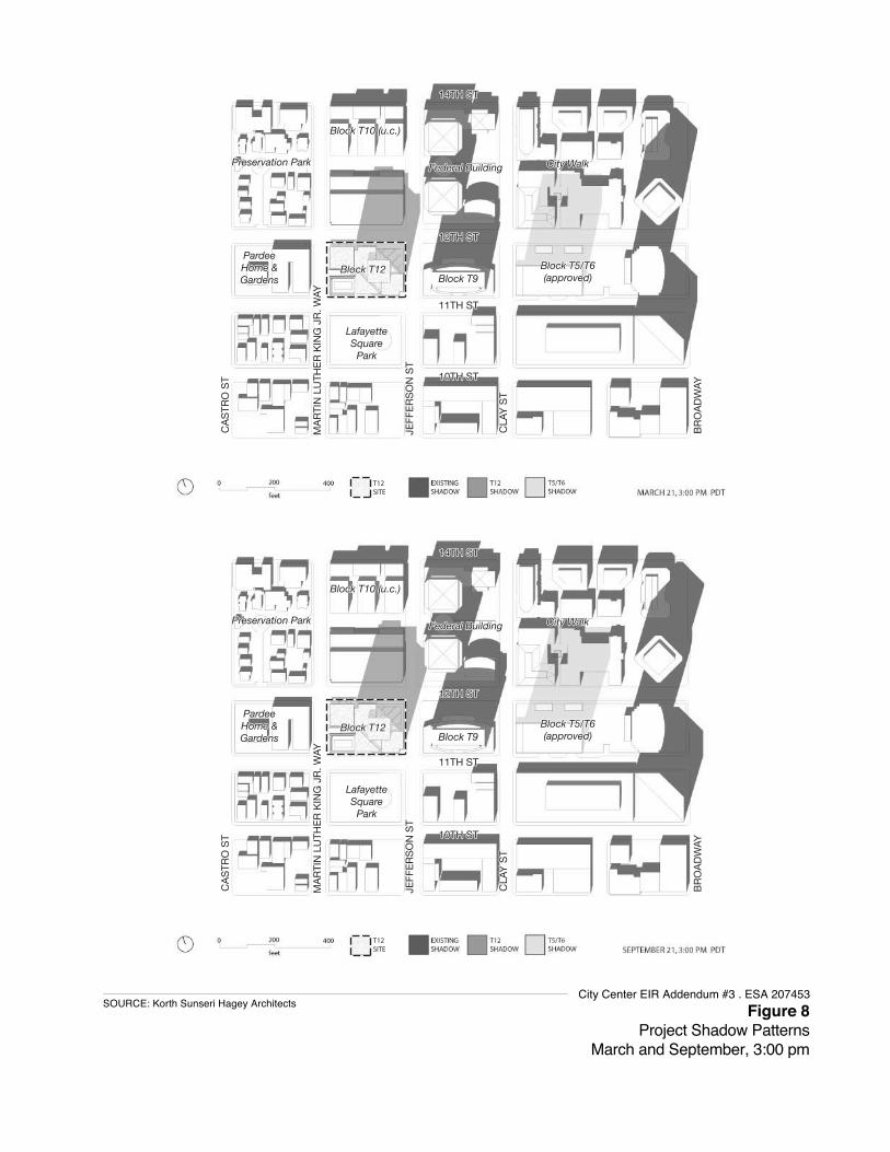
14TH ST14TH ST
MA
RTI
N L
UTH
ER
KIN
G J
R. W
AYM
AR
TIN
LU
THE
R K
ING
JR
. WAY
CA
STR
O S
TC
AS
TRO
ST
CLA
Y S
TC
LAY
ST
BR
OA
DW
AYB
RO
AD
WAY
JEFF
ER
SO
N S
TJE
FFE
RS
ON
ST
12TH ST12TH ST
11TH ST11TH ST
10TH ST10TH ST
Block T10 (u.c.)Block T10 (u.c.)
Block T5/T6Block T5/T6(approved)(approved)Block T9Block T9
Block T12Block T12PardeePardeeHome &Home &GardensGardens
LafayetteLafayetteSquareSquare
ParkPark
Federal BuildingFederal Building City WalkCity WalkPreservation ParkPreservation Park
14TH ST
MA
RTI
N L
UTH
ER
KIN
G J
R. W
AY
CA
STR
O S
T
CLA
Y S
T
BR
OA
DW
AY
JEFF
ER
SO
N S
T
12TH ST
11TH ST
10TH ST
Block T10 (u.c.)
Block T5/T6(approved)Block T9
Block T12PardeeHome &Gardens
LafayetteSquare
Park
Federal Building City WalkPreservation Park
14TH ST14TH ST
MA
RTI
N L
UTH
ER
KIN
G J
R. W
AYM
AR
TIN
LU
THE
R K
ING
JR
. WAY
CA
STR
O S
TC
AS
TRO
ST
CLA
Y S
TC
LAY
ST
BR
OA
DW
AYB
RO
AD
WAY
JEFF
ER
SO
N S
TJE
FFE
RS
ON
ST
12TH ST12TH ST
11TH ST11TH ST
10TH ST10TH ST
Block T10 (u.c.)Block T10 (u.c.)
Block T5/T6Block T5/T6(approved)(approved)Block T9Block T9
Block T12Block T12PardeePardeeHome &Home &GardensGardens
LafayetteLafayetteSquareSquare
ParkPark
Federal BuildingFederal Building City WalkCity WalkPreservation ParkPreservation Park
14TH ST
MA
RTI
N L
UTH
ER
KIN
G J
R. W
AY
CA
STR
O S
T
CLA
Y S
T
BR
OA
DW
AY
JEFF
ER
SO
N S
T
12TH ST
11TH ST
10TH ST
Block T10 (u.c.)
Block T5/T6(approved)Block T9
Block T12PardeeHome &Gardens
LafayetteSquare
Park
Federal Building City WalkPreservation Park
T12SITE
T12SITE
Figure 8Project Shadow Patterns
March and September, 3:00 pm
SOURCE: Korth Sunseri Hagey ArchitectsCity Center EIR Addendum #3 . ESA 207453

APPENDIX B Transportation LOS Sheets and Background Detail


HCM Signalized Intersection Capacity Analysis1: Broadway & W Grand Ave 2/6/2015
Oakland City Center 12:00 pm 8/14/2014 Existing AM Synchro 8 ReportFehr & Peers Page 1
Movement EBL EBT EBR WBL WBT WBR NBL NBT NBR SBL SBT SBRLane ConfigurationsVolume (vph) 58 447 36 89 322 51 74 342 101 34 290 95Ideal Flow (vphpl) 1900 1900 1900 1900 1900 1900 1900 1900 1900 1900 1900 1900Total Lost time (s) 4.0 4.0 4.0 4.0 4.0 4.0 4.0 4.0Lane Util. Factor 1.00 0.95 0.95 1.00 0.95 1.00 1.00 0.95Frpb, ped/bikes 1.00 0.99 0.99 1.00 1.00 0.91 1.00 0.98Flpb, ped/bikes 0.97 1.00 0.99 0.96 1.00 1.00 0.95 1.00Frt 1.00 0.99 0.98 1.00 1.00 0.85 1.00 0.96Flt Protected 0.95 1.00 0.99 0.95 1.00 1.00 0.95 1.00Satd. Flow (prot) 1541 3130 3053 1526 3185 1087 1515 2997Flt Permitted 0.37 1.00 0.70 0.52 1.00 1.00 0.55 1.00Satd. Flow (perm) 604 3130 2157 841 3185 1087 871 2997Peak-hour factor, PHF 1.00 1.00 1.00 1.00 1.00 1.00 1.00 1.00 1.00 1.00 1.00 1.00Adj. Flow (vph) 58 447 36 89 322 51 74 342 101 34 290 95RTOR Reduction (vph) 0 10 0 0 16 0 0 0 38 0 24 0Lane Group Flow (vph) 58 473 0 0 446 0 74 342 63 34 361 0Confl. Peds. (#/hr) 71 73 73 71 84 80 80 84Confl. Bikes (#/hr) 15 21 9 34Bus Blockages (#/hr) 0 0 0 0 0 10 0 0 10 0 0 10Parking (#/hr) 5 5 5 5Turn Type Perm NA Perm NA Perm NA Perm Perm NAProtected Phases 4 8 2 6Permitted Phases 4 8 2 2 6Actuated Green, G (s) 23.8 23.8 23.8 53.2 53.2 53.2 53.2 53.2Effective Green, g (s) 23.8 23.8 23.8 53.2 53.2 53.2 53.2 53.2Actuated g/C Ratio 0.28 0.28 0.28 0.63 0.63 0.63 0.63 0.63Clearance Time (s) 4.0 4.0 4.0 4.0 4.0 4.0 4.0 4.0Vehicle Extension (s) 2.0 2.0 2.0 2.0 2.0 2.0 2.0 2.0Lane Grp Cap (vph) 169 876 603 526 1993 680 545 1875v/s Ratio Prot 0.15 0.11 c0.12v/s Ratio Perm 0.10 c0.21 0.09 0.06 0.04v/c Ratio 0.34 0.54 0.74 0.14 0.17 0.09 0.06 0.19Uniform Delay, d1 24.4 26.0 27.8 6.5 6.7 6.3 6.2 6.8Progression Factor 1.00 1.00 1.00 1.00 1.00 1.00 1.00 1.00Incremental Delay, d2 0.4 0.3 4.1 0.6 0.2 0.3 0.2 0.2Delay (s) 24.8 26.3 31.9 7.1 6.9 6.6 6.4 7.0Level of Service C C C A A A A AApproach Delay (s) 26.1 31.9 6.8 6.9Approach LOS C C A A
Intersection SummaryHCM 2000 Control Delay 18.2 HCM 2000 Level of Service BHCM 2000 Volume to Capacity ratio 0.36Actuated Cycle Length (s) 85.0 Sum of lost time (s) 8.0Intersection Capacity Utilization 87.3% ICU Level of Service EAnalysis Period (min) 15c Critical Lane Group

HCM Signalized Intersection Capacity Analysis2: Brush St & 12th St & I-980 Off-Ramp 2/6/2015
Oakland City Center 12:00 pm 8/14/2014 Existing AM Synchro 8 ReportFehr & Peers Page 2
Movement EBR WBL WBT SBT SBR SWL SWRLane ConfigurationsVolume (vph) 2 53 116 418 89 1816 18Ideal Flow (vphpl) 1900 1900 1900 1900 1900 1900 1900Total Lost time (s) 4.5 4.5 4.5 4.5 5.0Lane Util. Factor 1.00 1.00 0.91 0.91 0.97Frpb, ped/bikes 0.93 1.00 1.00 1.00 1.00Flpb, ped/bikes 1.00 0.94 1.00 1.00 1.00Frt 0.86 1.00 1.00 0.97 1.00Flt Protected 1.00 0.95 1.00 1.00 0.95Satd. Flow (prot) 1345 1496 4577 4254 3185Flt Permitted 1.00 0.95 1.00 1.00 0.95Satd. Flow (perm) 1345 1496 4577 4254 3185Peak-hour factor, PHF 1.00 1.00 1.00 1.00 1.00 1.00 1.00Adj. Flow (vph) 2 53 116 418 89 1816 18RTOR Reduction (vph) 2 46 0 29 0 0 0Lane Group Flow (vph) 0 7 116 478 0 1834 0Confl. Peds. (#/hr) 35 35 4 35 4Confl. Bikes (#/hr) 1 1Parking (#/hr) 5 5Turn Type Perm Perm NA NA ProtProtected Phases 4 5 6Permitted Phases 4 4Actuated Green, G (s) 14.8 14.8 14.8 16.5 69.7Effective Green, g (s) 14.8 14.8 14.8 16.5 69.7Actuated g/C Ratio 0.13 0.13 0.13 0.14 0.61Clearance Time (s) 4.5 4.5 4.5 4.5 5.0Vehicle Extension (s) 3.0 3.0 3.0 3.0 3.0Lane Grp Cap (vph) 173 192 589 610 1930v/s Ratio Prot c0.03 c0.11 c0.58v/s Ratio Perm 0.00 0.00v/c Ratio 0.00 0.04 0.20 0.78 0.95Uniform Delay, d1 43.7 43.9 44.8 47.5 21.0Progression Factor 1.00 1.00 1.00 1.00 1.00Incremental Delay, d2 0.0 0.1 0.2 6.5 11.7Delay (s) 43.7 43.9 45.0 54.0 32.7Level of Service D D D D CApproach Delay (s) 44.6 54.0 32.7Approach LOS D D C
Intersection SummaryHCM 2000 Control Delay 37.8 HCM 2000 Level of Service DHCM 2000 Volume to Capacity ratio 0.81Actuated Cycle Length (s) 115.0 Sum of lost time (s) 14.0Intersection Capacity Utilization 84.6% ICU Level of Service EAnalysis Period (min) 15c Critical Lane Group

HCM Signalized Intersection Capacity Analysis3: Broadway & 12th St 2/6/2015
Oakland City Center 12:00 pm 8/14/2014 Existing AM Synchro 8 ReportFehr & Peers Page 3
Movement EBL EBT EBR WBL WBT WBR NBL NBT NBR SBL SBT SBRLane ConfigurationsVolume (vph) 0 0 0 94 303 71 93 395 0 0 400 53Ideal Flow (vphpl) 1900 1900 1900 1900 1900 1900 1900 1900 1900 1900 1900 1900Total Lost time (s) 4.0 4.0 4.5 4.5Lane Util. Factor 0.91 1.00 0.95 0.95Frpb, ped/bikes 0.98 1.00 1.00 0.96Flpb, ped/bikes 0.97 1.00 1.00 1.00Frt 0.98 1.00 1.00 0.98Flt Protected 0.99 0.95 1.00 1.00Satd. Flow (prot) 4001 1593 3122 2933Flt Permitted 0.99 0.95 1.00 1.00Satd. Flow (perm) 4001 1593 3122 2933Peak-hour factor, PHF 1.00 1.00 1.00 1.00 1.00 1.00 1.00 1.00 1.00 1.00 1.00 1.00Adj. Flow (vph) 0 0 0 94 303 71 93 395 0 0 400 53RTOR Reduction (vph) 0 0 0 0 43 0 0 0 0 0 17 0Lane Group Flow (vph) 0 0 0 0 425 0 93 395 0 0 436 0Confl. Peds. (#/hr) 164 113 522 522Confl. Bikes (#/hr) 6 10Bus Blockages (#/hr) 0 0 0 0 10 10 0 10 0 0 10 10Parking (#/hr) 5 5 5Turn Type Perm NA Prot NA NAProtected Phases 4 5 2 6Permitted Phases 4Actuated Green, G (s) 21.0 4.5 30.5 22.0Effective Green, g (s) 21.0 4.5 30.5 22.0Actuated g/C Ratio 0.35 0.08 0.51 0.37Clearance Time (s) 4.0 4.0 4.5 4.5Lane Grp Cap (vph) 1400 119 1587 1075v/s Ratio Prot c0.06 0.13 c0.15v/s Ratio Perm 0.11v/c Ratio 0.30 0.78 0.25 0.41Uniform Delay, d1 14.2 27.3 8.3 14.1Progression Factor 1.00 1.57 2.28 1.00Incremental Delay, d2 0.6 36.0 0.3 1.1Delay (s) 14.7 78.9 19.3 15.3Level of Service B E B BApproach Delay (s) 0.0 14.7 30.6 15.3Approach LOS A B C B
Intersection SummaryHCM 2000 Control Delay 20.4 HCM 2000 Level of Service CHCM 2000 Volume to Capacity ratio 0.40Actuated Cycle Length (s) 60.0 Sum of lost time (s) 12.5Intersection Capacity Utilization 49.2% ICU Level of Service AAnalysis Period (min) 15c Critical Lane Group

HCM Signalized Intersection Capacity Analysis4: Broadway & 11th St 2/6/2015
Oakland City Center 12:00 pm 8/14/2014 Existing AM Synchro 8 ReportFehr & Peers Page 4
Movement EBL EBT EBR WBL WBT WBR NBL NBT NBR SBL SBT SBRLane ConfigurationsVolume (vph) 85 448 97 0 0 0 0 402 74 88 403 0Ideal Flow (vphpl) 1900 1900 1900 1900 1900 1900 1900 1900 1900 1900 1900 1900Total Lost time (s) 4.0 4.0 4.0 4.0Lane Util. Factor 0.86 0.95 1.00 0.95Frpb, ped/bikes 0.98 0.95 1.00 1.00Flpb, ped/bikes 0.98 1.00 1.00 1.00Frt 0.98 0.98 1.00 1.00Flt Protected 0.99 1.00 0.95 1.00Satd. Flow (prot) 5150 2898 1593 3122Flt Permitted 0.99 1.00 0.95 1.00Satd. Flow (perm) 5150 2898 1593 3122Peak-hour factor, PHF 1.00 1.00 1.00 1.00 1.00 1.00 1.00 1.00 1.00 1.00 1.00 1.00Adj. Flow (vph) 85 448 97 0 0 0 0 402 74 88 403 0RTOR Reduction (vph) 0 55 0 0 0 0 0 25 0 0 0 0Lane Group Flow (vph) 0 575 0 0 0 0 0 451 0 88 403 0Confl. Peds. (#/hr) 139 172 313 313Confl. Bikes (#/hr) 11 3Bus Blockages (#/hr) 0 10 10 0 0 0 0 10 10 0 10 0Parking (#/hr) 5 5 5Turn Type Perm NA NA Prot NAProtected Phases 4 2 1 6Permitted Phases 4Actuated Green, G (s) 23.0 20.0 5.0 29.0Effective Green, g (s) 23.0 20.0 5.0 29.0Actuated g/C Ratio 0.38 0.33 0.08 0.48Clearance Time (s) 4.0 4.0 4.0 4.0Lane Grp Cap (vph) 1974 966 132 1508v/s Ratio Prot c0.16 c0.06 0.13v/s Ratio Perm 0.11v/c Ratio 0.29 0.47 0.67 0.27Uniform Delay, d1 12.8 15.8 26.7 9.2Progression Factor 1.00 1.00 0.64 1.03Incremental Delay, d2 0.4 1.6 22.2 0.4Delay (s) 13.2 17.4 39.2 9.9Level of Service B B D AApproach Delay (s) 13.2 0.0 17.4 15.2Approach LOS B A B B
Intersection SummaryHCM 2000 Control Delay 15.1 HCM 2000 Level of Service BHCM 2000 Volume to Capacity ratio 0.40Actuated Cycle Length (s) 60.0 Sum of lost time (s) 12.0Intersection Capacity Utilization 49.2% ICU Level of Service AAnalysis Period (min) 15c Critical Lane Group

HCM Signalized Intersection Capacity Analysis8: Broadway & 5th Street & I-880 SB On-Ramp & Alameda 2/6/2015
Oakland City Center 12:00 pm 8/14/2014 Existing AM Synchro 8 ReportFehr & Peers Page 8
Movement EBL2 EBL EBT EBR EBR2 NBT NBR NBR2 SBL2 SBL SBTLane ConfigurationsVolume (vph) 43 595 141 31 51 131 155 57 326 130 295Ideal Flow (vphpl) 1900 1900 1900 1900 1900 1900 1900 1900 1900 1900 1900Total Lost time (s) 4.0 4.0 4.0 4.0 4.0 4.0 4.5 4.0Lane Util. Factor 0.91 0.91 1.00 0.95 1.00 1.00 1.00 1.00Frpb, ped/bikes 1.00 0.99 0.95 1.00 0.89 1.00 1.00 1.00Flpb, ped/bikes 1.00 1.00 1.00 1.00 1.00 1.00 1.00 1.00Frt 1.00 0.99 0.85 1.00 0.85 1.00 1.00 1.00Flt Protected 0.95 0.97 1.00 1.00 1.00 0.95 0.95 1.00Satd. Flow (prot) 1449 2913 1356 3185 1262 1593 1593 1676Flt Permitted 0.95 0.97 1.00 1.00 1.00 0.95 0.95 1.00Satd. Flow (perm) 1449 2913 1356 3185 1262 1593 1593 1676Peak-hour factor, PHF 1.00 1.00 1.00 1.00 1.00 1.00 1.00 1.00 1.00 1.00 1.00Adj. Flow (vph) 43 595 141 31 51 131 155 57 326 130 295RTOR Reduction (vph) 0 0 0 0 35 0 0 0 0 0 0Lane Group Flow (vph) 0 358 452 0 16 131 212 0 326 130 295Confl. Peds. (#/hr) 25 25 40 40 40 40Confl. Bikes (#/hr) 1 1Turn Type Perm Perm NA Perm NA Perm Prot Prot NAProtected Phases 4 2 1 1 6Permitted Phases 4 4 4 2Actuated Green, G (s) 26.8 26.8 26.8 18.5 18.5 31.2 31.2 53.2Effective Green, g (s) 28.3 28.3 28.3 18.0 18.0 31.7 31.2 53.7Actuated g/C Ratio 0.31 0.31 0.31 0.20 0.20 0.35 0.35 0.60Clearance Time (s) 5.5 5.5 5.5 3.5 3.5 4.5 4.5 4.5Vehicle Extension (s) 2.0 2.0 2.0 2.0 2.0 2.0 2.0 2.0Lane Grp Cap (vph) 455 915 426 637 252 561 552 1000v/s Ratio Prot 0.04 c0.20 0.08 0.18v/s Ratio Perm c0.25 0.16 0.01 c0.17v/c Ratio 0.79 0.49 0.04 0.21 0.84 0.58 0.24 0.29Uniform Delay, d1 28.1 25.0 21.4 30.0 34.6 23.7 20.9 8.9Progression Factor 1.00 1.00 1.00 1.00 1.00 1.00 1.00 1.00Incremental Delay, d2 8.1 0.2 0.0 0.1 20.9 4.4 1.0 0.8Delay (s) 36.2 25.2 21.4 30.1 55.5 28.1 21.9 9.6Level of Service D C C C E C C AApproach Delay (s) 29.5 45.8 19.8Approach LOS C D B
Intersection SummaryHCM 2000 Control Delay 28.6 HCM 2000 Level of Service CHCM 2000 Volume to Capacity ratio 0.72Actuated Cycle Length (s) 90.0 Sum of lost time (s) 12.5Intersection Capacity Utilization 66.3% ICU Level of Service CAnalysis Period (min) 15c Critical Lane Group

HCM Signalized Intersection Capacity Analysis1: Broadway & W Grand Ave 2/6/2015
Oakland City Center 12:00 pm 8/14/2014 Existing PM Synchro 8 ReportFehr & Peers Page 1
Movement EBL EBT EBR WBL WBT WBR NBL NBT NBR SBL SBT SBRLane ConfigurationsVolume (vph) 100 630 89 71 341 40 240 565 133 85 389 94Ideal Flow (vphpl) 1900 1900 1900 1900 1900 1900 1900 1900 1900 1900 1900 1900Total Lost time (s) 4.0 4.0 4.0 4.0 4.0 4.0 4.0 4.0Lane Util. Factor 1.00 0.95 0.95 1.00 0.95 1.00 1.00 0.95Frpb, ped/bikes 1.00 0.99 0.99 1.00 1.00 0.91 1.00 0.99Flpb, ped/bikes 0.98 1.00 1.00 0.98 1.00 1.00 0.98 1.00Frt 1.00 0.98 0.99 1.00 1.00 0.85 1.00 0.97Flt Protected 0.95 1.00 0.99 0.95 1.00 1.00 0.95 1.00Satd. Flow (prot) 1557 3098 3091 1564 3185 1093 1561 3059Flt Permitted 0.40 1.00 0.66 0.46 1.00 1.00 0.42 1.00Satd. Flow (perm) 648 3098 2043 760 3185 1093 685 3059Peak-hour factor, PHF 1.00 1.00 1.00 1.00 1.00 1.00 1.00 1.00 1.00 1.00 1.00 1.00Adj. Flow (vph) 100 630 89 71 341 40 240 565 133 85 389 94RTOR Reduction (vph) 0 17 0 0 12 0 0 0 53 0 17 0Lane Group Flow (vph) 100 702 0 0 440 0 240 565 80 85 466 0Confl. Peds. (#/hr) 47 62 62 47 43 66 47 43Confl. Bikes (#/hr) 10 19 35 22Bus Blockages (#/hr) 0 0 0 0 0 10 0 0 10 0 0 10Parking (#/hr) 5 5 5 5Turn Type Perm NA Perm NA Perm NA Perm Perm NAProtected Phases 4 8 2 6Permitted Phases 4 8 2 2 6Actuated Green, G (s) 25.8 25.8 25.8 51.2 51.2 51.2 51.2 51.2Effective Green, g (s) 25.8 25.8 25.8 51.2 51.2 51.2 51.2 51.2Actuated g/C Ratio 0.30 0.30 0.30 0.60 0.60 0.60 0.60 0.60Clearance Time (s) 4.0 4.0 4.0 4.0 4.0 4.0 4.0 4.0Vehicle Extension (s) 2.0 2.0 2.0 2.0 2.0 2.0 2.0 2.0Lane Grp Cap (vph) 196 940 620 457 1918 658 412 1842v/s Ratio Prot c0.23 0.18 0.15v/s Ratio Perm 0.15 0.22 c0.32 0.07 0.12v/c Ratio 0.51 0.75 0.71 0.53 0.29 0.12 0.21 0.25Uniform Delay, d1 24.4 26.7 26.3 9.8 8.2 7.3 7.7 7.9Progression Factor 1.00 1.00 1.00 1.00 1.00 1.00 1.00 1.00Incremental Delay, d2 0.9 2.9 3.1 4.3 0.4 0.4 1.1 0.3Delay (s) 25.3 29.5 29.3 14.1 8.6 7.6 8.8 8.3Level of Service C C C B A A A AApproach Delay (s) 29.0 29.3 9.8 8.3Approach LOS C C A A
Intersection SummaryHCM 2000 Control Delay 18.4 HCM 2000 Level of Service BHCM 2000 Volume to Capacity ratio 0.60Actuated Cycle Length (s) 85.0 Sum of lost time (s) 8.0Intersection Capacity Utilization 97.3% ICU Level of Service FAnalysis Period (min) 15c Critical Lane Group

HCM Signalized Intersection Capacity Analysis2: Brush St & 12th St & I-980 Off-Ramp 2/6/2015
Oakland City Center 12:00 pm 8/14/2014 Existing PM Synchro 8 ReportFehr & Peers Page 2
Movement EBR WBL WBT SBT SBR SWL SWRLane ConfigurationsVolume (vph) 3 89 119 275 46 986 43Ideal Flow (vphpl) 1900 1900 1900 1900 1900 1900 1900Total Lost time (s) 4.5 4.5 4.5 4.5 5.0Lane Util. Factor 1.00 1.00 0.91 0.91 0.97Frpb, ped/bikes 0.92 1.00 1.00 0.99 1.00Flpb, ped/bikes 1.00 0.93 1.00 1.00 1.00Frt 0.86 1.00 1.00 0.98 0.99Flt Protected 1.00 0.95 1.00 1.00 0.95Satd. Flow (prot) 1337 1485 4577 4261 3185Flt Permitted 1.00 0.95 1.00 1.00 0.95Satd. Flow (perm) 1337 1485 4577 4261 3185Peak-hour factor, PHF 1.00 1.00 1.00 1.00 1.00 1.00 1.00Adj. Flow (vph) 3 89 119 275 46 986 43RTOR Reduction (vph) 2 74 0 31 0 0 0Lane Group Flow (vph) 1 15 119 290 0 1029 0Confl. Peds. (#/hr) 53 53 23 53 23Parking (#/hr) 5 5Turn Type Perm Perm NA NA ProtProtected Phases 4 5 6Permitted Phases 4 4Actuated Green, G (s) 14.6 14.6 14.6 11.2 45.2Effective Green, g (s) 14.6 14.6 14.6 11.2 45.2Actuated g/C Ratio 0.17 0.17 0.17 0.13 0.53Clearance Time (s) 4.5 4.5 4.5 4.5 5.0Vehicle Extension (s) 3.0 3.0 3.0 3.0 3.0Lane Grp Cap (vph) 229 255 786 561 1693v/s Ratio Prot c0.03 c0.07 c0.32v/s Ratio Perm 0.00 0.01v/c Ratio 0.00 0.06 0.15 0.52 0.61Uniform Delay, d1 29.2 29.5 29.9 34.4 13.8Progression Factor 1.00 1.00 1.00 1.00 1.00Incremental Delay, d2 0.0 0.1 0.1 0.8 1.6Delay (s) 29.2 29.6 30.0 35.2 15.4Level of Service C C C D BApproach Delay (s) 29.8 35.2 15.4Approach LOS C D B
Intersection SummaryHCM 2000 Control Delay 21.4 HCM 2000 Level of Service CHCM 2000 Volume to Capacity ratio 0.50Actuated Cycle Length (s) 85.0 Sum of lost time (s) 14.0Intersection Capacity Utilization 60.1% ICU Level of Service BAnalysis Period (min) 15c Critical Lane Group

HCM Signalized Intersection Capacity Analysis3: Broadway & 12th St 2/6/2015
Oakland City Center 12:00 pm 8/14/2014 Existing PM Synchro 8 ReportFehr & Peers Page 3
Movement EBL EBT EBR WBL WBT WBR NBL NBT NBR SBL SBT SBRLane ConfigurationsVolume (vph) 0 0 0 142 509 101 112 453 0 0 589 79Ideal Flow (vphpl) 1900 1900 1900 1900 1900 1900 1900 1900 1900 1900 1900 1900Total Lost time (s) 4.0 4.0 4.5 4.5Lane Util. Factor 0.91 1.00 0.95 0.95Frpb, ped/bikes 0.99 1.00 1.00 0.96Flpb, ped/bikes 0.98 1.00 1.00 1.00Frt 0.98 1.00 1.00 0.98Flt Protected 0.99 0.95 1.00 1.00Satd. Flow (prot) 4085 1450 3122 2938Flt Permitted 0.99 0.95 1.00 1.00Satd. Flow (perm) 4085 1450 3122 2938Peak-hour factor, PHF 1.00 1.00 1.00 1.00 1.00 1.00 1.00 1.00 1.00 1.00 1.00 1.00Adj. Flow (vph) 0 0 0 142 509 101 112 453 0 0 589 79RTOR Reduction (vph) 0 0 0 0 19 0 0 0 0 0 17 0Lane Group Flow (vph) 0 0 0 0 733 0 112 453 0 0 651 0Confl. Peds. (#/hr) 125 48 446 455 455 446Confl. Bikes (#/hr) 6 10 9Heavy Vehicles (%) 2% 2% 2% 2% 2% 2% 12% 2% 2% 2% 2% 2%Bus Blockages (#/hr) 0 0 0 0 10 10 0 10 0 0 10 10Parking (#/hr) 5 5 5Turn Type Perm NA Prot NA NAProtected Phases 4 5 2 6Permitted Phases 4Actuated Green, G (s) 21.0 4.5 30.5 22.0Effective Green, g (s) 21.0 4.5 30.5 22.0Actuated g/C Ratio 0.35 0.08 0.51 0.37Clearance Time (s) 4.0 4.0 4.5 4.5Lane Grp Cap (vph) 1429 108 1587 1077v/s Ratio Prot c0.08 0.15 c0.22v/s Ratio Perm 0.18v/c Ratio 0.51 1.04 0.29 0.60Uniform Delay, d1 15.4 27.8 8.5 15.5Progression Factor 1.00 1.15 1.10 1.00Incremental Delay, d2 1.3 91.4 0.4 2.5Delay (s) 16.8 123.4 9.7 18.0Level of Service B F A BApproach Delay (s) 0.0 16.8 32.2 18.0Approach LOS A B C B
Intersection SummaryHCM 2000 Control Delay 21.6 HCM 2000 Level of Service CHCM 2000 Volume to Capacity ratio 0.60Actuated Cycle Length (s) 60.0 Sum of lost time (s) 12.5Intersection Capacity Utilization 56.8% ICU Level of Service BAnalysis Period (min) 15c Critical Lane Group

HCM Signalized Intersection Capacity Analysis4: Broadway & 11th St 2/6/2015
Oakland City Center 12:00 pm 8/14/2014 Existing PM Synchro 8 ReportFehr & Peers Page 4
Movement EBL EBT EBR WBL WBT WBR NBL NBT NBR SBL SBT SBRLane ConfigurationsVolume (vph) 95 428 148 0 0 0 0 457 80 112 601 0Ideal Flow (vphpl) 1900 1900 1900 1900 1900 1900 1900 1900 1900 1900 1900 1900Total Lost time (s) 4.0 4.0 4.0 4.0Lane Util. Factor 0.86 0.95 1.00 0.95Frpb, ped/bikes 0.93 0.95 1.00 1.00Flpb, ped/bikes 0.99 1.00 1.00 1.00Frt 0.97 0.98 1.00 1.00Flt Protected 0.99 1.00 0.95 1.00Satd. Flow (prot) 4868 2885 1593 3122Flt Permitted 0.99 1.00 0.95 1.00Satd. Flow (perm) 4868 2885 1593 3122Peak-hour factor, PHF 1.00 1.00 1.00 1.00 1.00 1.00 1.00 1.00 1.00 1.00 1.00 1.00Adj. Flow (vph) 95 428 148 0 0 0 0 457 80 112 601 0RTOR Reduction (vph) 0 7 0 0 0 0 0 23 0 0 0 0Lane Group Flow (vph) 0 664 0 0 0 0 0 514 0 112 601 0Confl. Peds. (#/hr) 77 535 490 535 535 490Confl. Bikes (#/hr) 6 9 16Bus Blockages (#/hr) 0 10 10 0 0 0 0 10 10 0 10 0Parking (#/hr) 5 5 5Turn Type Perm NA NA Prot NAProtected Phases 4 2 1 6Permitted Phases 4Actuated Green, G (s) 23.0 20.0 5.0 29.0Effective Green, g (s) 23.0 20.0 5.0 29.0Actuated g/C Ratio 0.38 0.33 0.08 0.48Clearance Time (s) 4.0 4.0 4.0 4.0Lane Grp Cap (vph) 1866 961 132 1508v/s Ratio Prot c0.18 c0.07 0.19v/s Ratio Perm 0.14v/c Ratio 0.36 0.53 0.85 0.40Uniform Delay, d1 13.2 16.2 27.1 9.9Progression Factor 1.00 1.00 0.90 1.76Incremental Delay, d2 0.5 2.1 39.2 0.6Delay (s) 13.7 18.4 63.6 18.1Level of Service B B E BApproach Delay (s) 13.7 0.0 18.4 25.2Approach LOS B A B C
Intersection SummaryHCM 2000 Control Delay 19.3 HCM 2000 Level of Service BHCM 2000 Volume to Capacity ratio 0.48Actuated Cycle Length (s) 60.0 Sum of lost time (s) 12.0Intersection Capacity Utilization 56.8% ICU Level of Service BAnalysis Period (min) 15c Critical Lane Group

HCM Signalized Intersection Capacity Analysis8: Broadway & 5th Street & I-880 SB On-Ramp & Alameda 2/6/2015
Oakland City Center 12:00 pm 8/14/2014 Existing PM Synchro 8 ReportFehr & Peers Page 8
Movement EBL2 EBL EBT EBR EBR2 NBT NBR NBR2 SBL2 SBL SBTLane ConfigurationsVolume (vph) 28 896 268 7 64 293 232 56 308 243 262Ideal Flow (vphpl) 1900 1900 1900 1900 1900 1900 1900 1900 1900 1900 1900Total Lost time (s) 4.0 4.0 4.0 4.0 4.0 3.5 4.0 4.0Lane Util. Factor 0.91 0.91 1.00 0.95 1.00 1.00 1.00 1.00Frpb, ped/bikes 1.00 1.00 0.95 1.00 0.81 1.00 1.00 1.00Flpb, ped/bikes 1.00 1.00 1.00 1.00 1.00 1.00 1.00 1.00Frt 1.00 1.00 0.85 1.00 0.85 1.00 1.00 1.00Flt Protected 0.95 0.97 1.00 1.00 1.00 0.95 0.95 1.00Satd. Flow (prot) 1449 2955 1353 3185 1149 1593 1593 1676Flt Permitted 0.95 0.97 1.00 1.00 1.00 0.95 0.95 1.00Satd. Flow (perm) 1449 2955 1353 3185 1149 1593 1593 1676Peak-hour factor, PHF 1.00 1.00 1.00 1.00 1.00 1.00 1.00 1.00 1.00 1.00 1.00Adj. Flow (vph) 28 896 268 7 64 293 232 56 308 243 262RTOR Reduction (vph) 0 0 0 0 38 0 0 0 0 0 0Lane Group Flow (vph) 0 503 696 0 26 293 288 0 308 243 262Confl. Peds. (#/hr) 26 26 71 71 71 71Confl. Bikes (#/hr) 1 1 2 2Turn Type Perm Perm NA Perm NA Perm Prot Prot NAProtected Phases 4 2 1 1 6Permitted Phases 4 4 4 2Actuated Green, G (s) 31.9 31.9 31.9 22.5 22.5 22.6 22.6 48.1Effective Green, g (s) 33.4 33.4 33.4 22.0 22.0 23.1 22.6 48.6Actuated g/C Ratio 0.37 0.37 0.37 0.24 0.24 0.26 0.25 0.54Clearance Time (s) 5.5 5.5 5.5 3.5 3.5 4.0 4.0 4.5Vehicle Extension (s) 2.0 2.0 2.0 2.0 2.0 2.0 2.0 2.0Lane Grp Cap (vph) 537 1096 502 778 280 408 400 905v/s Ratio Prot 0.09 c0.19 0.15 0.16v/s Ratio Perm c0.35 0.24 0.02 c0.25v/c Ratio 0.94 0.64 0.05 0.38 1.03 0.75 0.61 0.29Uniform Delay, d1 27.3 23.3 18.1 28.3 34.0 30.8 29.8 11.3Progression Factor 1.00 1.00 1.00 1.00 1.00 1.00 1.00 1.00Incremental Delay, d2 23.7 0.9 0.0 0.1 61.4 12.2 6.7 0.8Delay (s) 51.0 24.2 18.2 28.4 95.4 43.1 36.5 12.1Level of Service D C B C F D D BApproach Delay (s) 34.5 61.6 31.1Approach LOS C E C
Intersection SummaryHCM 2000 Control Delay 39.4 HCM 2000 Level of Service DHCM 2000 Volume to Capacity ratio 0.91Actuated Cycle Length (s) 90.0 Sum of lost time (s) 12.0Intersection Capacity Utilization 81.3% ICU Level of Service DAnalysis Period (min) 15c Critical Lane Group

HCM Signalized Intersection Capacity Analysis1: Broadway & W Grand Ave 2/9/2015
Oakland City Center 12:00 pm 8/14/2014 Existing Plus Project, AM Synchro 8 ReportFehr & Peers Page 1
Movement EBL EBT EBR WBL WBT WBR NBL NBT NBR SBL SBT SBRLane ConfigurationsVolume (vph) 58 447 36 89 322 51 74 346 101 34 299 95Ideal Flow (vphpl) 1900 1900 1900 1900 1900 1900 1900 1900 1900 1900 1900 1900Total Lost time (s) 4.0 4.0 4.0 4.0 4.0 4.0 4.0 4.0Lane Util. Factor 1.00 0.95 0.95 1.00 0.95 1.00 1.00 0.95Frpb, ped/bikes 1.00 0.99 0.99 1.00 1.00 0.91 1.00 0.98Flpb, ped/bikes 0.97 1.00 0.99 0.96 1.00 1.00 0.95 1.00Frt 1.00 0.99 0.98 1.00 1.00 0.85 1.00 0.96Flt Protected 0.95 1.00 0.99 0.95 1.00 1.00 0.95 1.00Satd. Flow (prot) 1541 3130 3053 1527 3185 1087 1515 3002Flt Permitted 0.37 1.00 0.70 0.52 1.00 1.00 0.54 1.00Satd. Flow (perm) 604 3130 2157 833 3185 1087 868 3002Peak-hour factor, PHF 1.00 1.00 1.00 1.00 1.00 1.00 1.00 1.00 1.00 1.00 1.00 1.00Adj. Flow (vph) 58 447 36 89 322 51 74 346 101 34 299 95RTOR Reduction (vph) 0 10 0 0 16 0 0 0 38 0 23 0Lane Group Flow (vph) 58 473 0 0 446 0 74 346 63 34 371 0Confl. Peds. (#/hr) 71 73 73 71 84 80 80 84Confl. Bikes (#/hr) 15 21 9 34Bus Blockages (#/hr) 0 0 0 0 0 10 0 0 10 0 0 10Parking (#/hr) 5 5 5 5Turn Type Perm NA Perm NA Perm NA Perm Perm NAProtected Phases 4 8 2 6Permitted Phases 4 8 2 2 6Actuated Green, G (s) 23.8 23.8 23.8 53.2 53.2 53.2 53.2 53.2Effective Green, g (s) 23.8 23.8 23.8 53.2 53.2 53.2 53.2 53.2Actuated g/C Ratio 0.28 0.28 0.28 0.63 0.63 0.63 0.63 0.63Clearance Time (s) 4.0 4.0 4.0 4.0 4.0 4.0 4.0 4.0Vehicle Extension (s) 2.0 2.0 2.0 2.0 2.0 2.0 2.0 2.0Lane Grp Cap (vph) 169 876 603 521 1993 680 543 1878v/s Ratio Prot 0.15 0.11 c0.12v/s Ratio Perm 0.10 c0.21 0.09 0.06 0.04v/c Ratio 0.34 0.54 0.74 0.14 0.17 0.09 0.06 0.20Uniform Delay, d1 24.4 26.0 27.8 6.5 6.7 6.3 6.2 6.8Progression Factor 1.00 1.00 1.00 1.00 1.00 1.00 1.00 1.00Incremental Delay, d2 0.4 0.3 4.1 0.6 0.2 0.3 0.2 0.2Delay (s) 24.8 26.3 31.9 7.1 6.9 6.6 6.4 7.0Level of Service C C C A A A A AApproach Delay (s) 26.1 31.9 6.8 7.0Approach LOS C C A A
Intersection SummaryHCM 2000 Control Delay 18.1 HCM 2000 Level of Service BHCM 2000 Volume to Capacity ratio 0.36Actuated Cycle Length (s) 85.0 Sum of lost time (s) 8.0Intersection Capacity Utilization 87.3% ICU Level of Service EAnalysis Period (min) 15c Critical Lane Group

HCM Signalized Intersection Capacity Analysis2: Brush St & 12th St & I-980 Off-Ramp 2/9/2015
Oakland City Center 12:00 pm 8/14/2014 Existing Plus Project, AM Synchro 8 ReportFehr & Peers Page 2
Movement EBR WBL WBT SBT SBR SWL SWRLane ConfigurationsVolume (vph) 2 53 116 432 89 1879 18Ideal Flow (vphpl) 1900 1900 1900 1900 1900 1900 1900Total Lost time (s) 4.5 4.5 4.5 4.5 5.0Lane Util. Factor 1.00 1.00 0.91 0.91 0.97Frpb, ped/bikes 0.93 1.00 1.00 1.00 1.00Flpb, ped/bikes 1.00 0.94 1.00 1.00 1.00Frt 0.86 1.00 1.00 0.97 1.00Flt Protected 1.00 0.95 1.00 1.00 0.95Satd. Flow (prot) 1345 1496 4577 4257 3185Flt Permitted 1.00 0.95 1.00 1.00 0.95Satd. Flow (perm) 1345 1496 4577 4257 3185Peak-hour factor, PHF 1.00 1.00 1.00 1.00 1.00 1.00 1.00Adj. Flow (vph) 2 53 116 432 89 1879 18RTOR Reduction (vph) 2 46 0 27 0 0 0Lane Group Flow (vph) 0 7 116 494 0 1897 0Confl. Peds. (#/hr) 35 35 4 35 4Confl. Bikes (#/hr) 1 1Parking (#/hr) 5 5Turn Type Perm Perm NA NA ProtProtected Phases 4 5 6Permitted Phases 4 4Actuated Green, G (s) 14.8 14.8 14.8 16.7 69.5Effective Green, g (s) 14.8 14.8 14.8 16.7 69.5Actuated g/C Ratio 0.13 0.13 0.13 0.15 0.60Clearance Time (s) 4.5 4.5 4.5 4.5 5.0Vehicle Extension (s) 3.0 3.0 3.0 3.0 3.0Lane Grp Cap (vph) 173 192 589 618 1924v/s Ratio Prot c0.03 c0.12 c0.60v/s Ratio Perm 0.00 0.00v/c Ratio 0.00 0.04 0.20 0.80 0.99Uniform Delay, d1 43.7 43.9 44.8 47.5 22.3Progression Factor 1.00 1.00 1.00 1.00 1.00Incremental Delay, d2 0.0 0.1 0.2 7.1 17.5Delay (s) 43.7 43.9 45.0 54.7 39.7Level of Service D D D D DApproach Delay (s) 44.6 54.7 39.7Approach LOS D D D
Intersection SummaryHCM 2000 Control Delay 43.1 HCM 2000 Level of Service DHCM 2000 Volume to Capacity ratio 0.84Actuated Cycle Length (s) 115.0 Sum of lost time (s) 14.0Intersection Capacity Utilization 86.9% ICU Level of Service EAnalysis Period (min) 15c Critical Lane Group
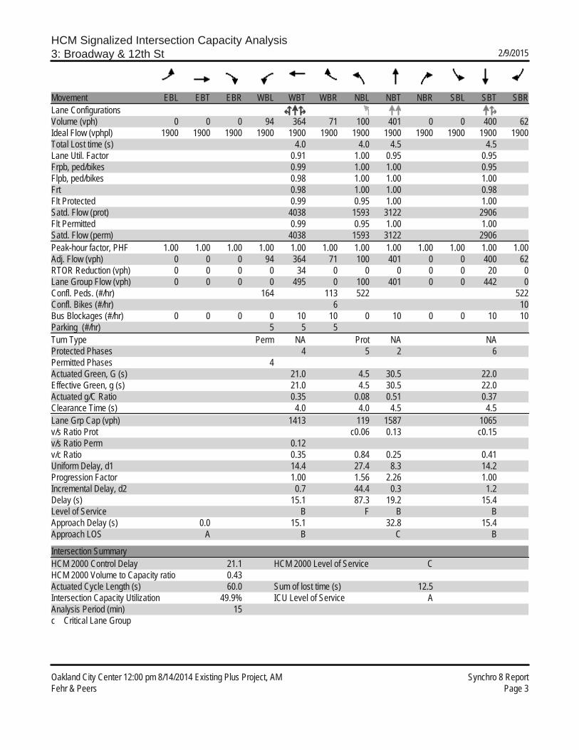
HCM Signalized Intersection Capacity Analysis3: Broadway & 12th St 2/9/2015
Oakland City Center 12:00 pm 8/14/2014 Existing Plus Project, AM Synchro 8 ReportFehr & Peers Page 3
Movement EBL EBT EBR WBL WBT WBR NBL NBT NBR SBL SBT SBRLane ConfigurationsVolume (vph) 0 0 0 94 364 71 100 401 0 0 400 62Ideal Flow (vphpl) 1900 1900 1900 1900 1900 1900 1900 1900 1900 1900 1900 1900Total Lost time (s) 4.0 4.0 4.5 4.5Lane Util. Factor 0.91 1.00 0.95 0.95Frpb, ped/bikes 0.99 1.00 1.00 0.95Flpb, ped/bikes 0.98 1.00 1.00 1.00Frt 0.98 1.00 1.00 0.98Flt Protected 0.99 0.95 1.00 1.00Satd. Flow (prot) 4038 1593 3122 2906Flt Permitted 0.99 0.95 1.00 1.00Satd. Flow (perm) 4038 1593 3122 2906Peak-hour factor, PHF 1.00 1.00 1.00 1.00 1.00 1.00 1.00 1.00 1.00 1.00 1.00 1.00Adj. Flow (vph) 0 0 0 94 364 71 100 401 0 0 400 62RTOR Reduction (vph) 0 0 0 0 34 0 0 0 0 0 20 0Lane Group Flow (vph) 0 0 0 0 495 0 100 401 0 0 442 0Confl. Peds. (#/hr) 164 113 522 522Confl. Bikes (#/hr) 6 10Bus Blockages (#/hr) 0 0 0 0 10 10 0 10 0 0 10 10Parking (#/hr) 5 5 5Turn Type Perm NA Prot NA NAProtected Phases 4 5 2 6Permitted Phases 4Actuated Green, G (s) 21.0 4.5 30.5 22.0Effective Green, g (s) 21.0 4.5 30.5 22.0Actuated g/C Ratio 0.35 0.08 0.51 0.37Clearance Time (s) 4.0 4.0 4.5 4.5Lane Grp Cap (vph) 1413 119 1587 1065v/s Ratio Prot c0.06 0.13 c0.15v/s Ratio Perm 0.12v/c Ratio 0.35 0.84 0.25 0.41Uniform Delay, d1 14.4 27.4 8.3 14.2Progression Factor 1.00 1.56 2.26 1.00Incremental Delay, d2 0.7 44.4 0.3 1.2Delay (s) 15.1 87.3 19.2 15.4Level of Service B F B BApproach Delay (s) 0.0 15.1 32.8 15.4Approach LOS A B C B
Intersection SummaryHCM 2000 Control Delay 21.1 HCM 2000 Level of Service CHCM 2000 Volume to Capacity ratio 0.43Actuated Cycle Length (s) 60.0 Sum of lost time (s) 12.5Intersection Capacity Utilization 49.9% ICU Level of Service AAnalysis Period (min) 15c Critical Lane Group

HCM Signalized Intersection Capacity Analysis4: Broadway & 11th St 2/9/2015
Oakland City Center 12:00 pm 8/14/2014 Existing Plus Project, AM Synchro 8 ReportFehr & Peers Page 4
Movement EBL EBT EBR WBL WBT WBR NBL NBT NBR SBL SBT SBRLane ConfigurationsVolume (vph) 91 491 131 0 0 0 0 409 74 88 403 0Ideal Flow (vphpl) 1900 1900 1900 1900 1900 1900 1900 1900 1900 1900 1900 1900Total Lost time (s) 4.0 4.0 4.0 4.0Lane Util. Factor 0.86 0.95 1.00 0.95Frpb, ped/bikes 0.97 0.95 1.00 1.00Flpb, ped/bikes 0.98 1.00 1.00 1.00Frt 0.97 0.98 1.00 1.00Flt Protected 0.99 1.00 0.95 1.00Satd. Flow (prot) 5107 2902 1593 3122Flt Permitted 0.99 1.00 0.95 1.00Satd. Flow (perm) 5107 2902 1593 3122Peak-hour factor, PHF 1.00 1.00 1.00 1.00 1.00 1.00 1.00 1.00 1.00 1.00 1.00 1.00Adj. Flow (vph) 91 491 131 0 0 0 0 409 74 88 403 0RTOR Reduction (vph) 0 68 0 0 0 0 0 25 0 0 0 0Lane Group Flow (vph) 0 645 0 0 0 0 0 458 0 88 403 0Confl. Peds. (#/hr) 139 172 313 313Confl. Bikes (#/hr) 11 3Bus Blockages (#/hr) 0 10 10 0 0 0 0 10 10 0 10 0Parking (#/hr) 5 5 5Turn Type Perm NA NA Prot NAProtected Phases 4 2 1 6Permitted Phases 4Actuated Green, G (s) 23.0 20.0 5.0 29.0Effective Green, g (s) 23.0 20.0 5.0 29.0Actuated g/C Ratio 0.38 0.33 0.08 0.48Clearance Time (s) 4.0 4.0 4.0 4.0Lane Grp Cap (vph) 1957 967 132 1508v/s Ratio Prot c0.16 c0.06 0.13v/s Ratio Perm 0.13v/c Ratio 0.33 0.47 0.67 0.27Uniform Delay, d1 13.1 15.8 26.7 9.2Progression Factor 1.00 1.00 0.64 1.04Incremental Delay, d2 0.5 1.7 22.0 0.4Delay (s) 13.5 17.5 39.0 10.0Level of Service B B D AApproach Delay (s) 13.5 0.0 17.5 15.2Approach LOS B A B B
Intersection SummaryHCM 2000 Control Delay 15.1 HCM 2000 Level of Service BHCM 2000 Volume to Capacity ratio 0.42Actuated Cycle Length (s) 60.0 Sum of lost time (s) 12.0Intersection Capacity Utilization 49.9% ICU Level of Service AAnalysis Period (min) 15c Critical Lane Group
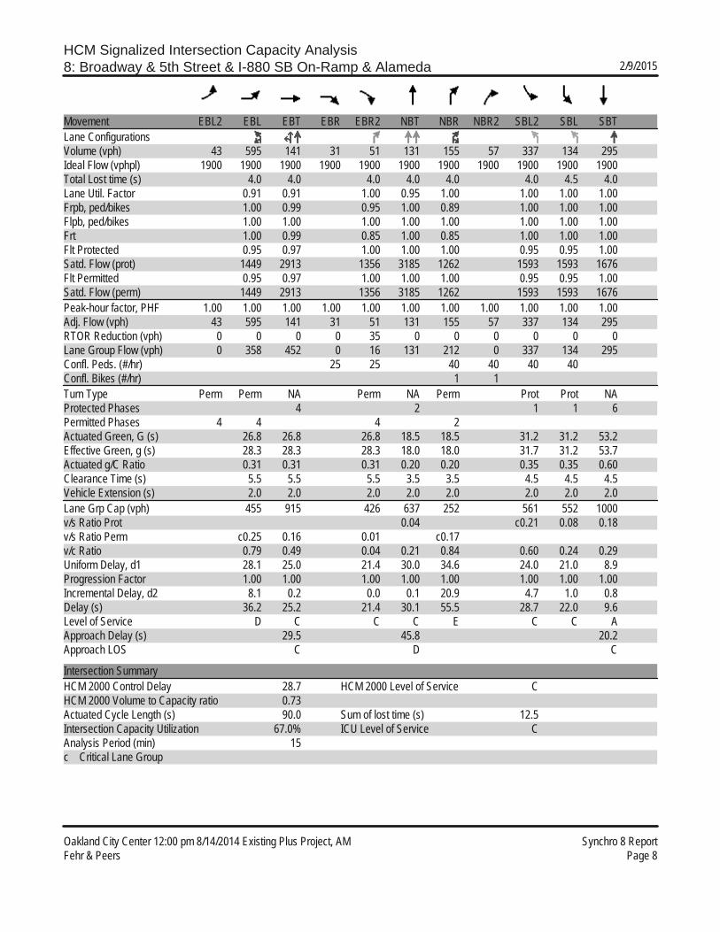
HCM Signalized Intersection Capacity Analysis8: Broadway & 5th Street & I-880 SB On-Ramp & Alameda 2/9/2015
Oakland City Center 12:00 pm 8/14/2014 Existing Plus Project, AM Synchro 8 ReportFehr & Peers Page 8
Movement EBL2 EBL EBT EBR EBR2 NBT NBR NBR2 SBL2 SBL SBTLane ConfigurationsVolume (vph) 43 595 141 31 51 131 155 57 337 134 295Ideal Flow (vphpl) 1900 1900 1900 1900 1900 1900 1900 1900 1900 1900 1900Total Lost time (s) 4.0 4.0 4.0 4.0 4.0 4.0 4.5 4.0Lane Util. Factor 0.91 0.91 1.00 0.95 1.00 1.00 1.00 1.00Frpb, ped/bikes 1.00 0.99 0.95 1.00 0.89 1.00 1.00 1.00Flpb, ped/bikes 1.00 1.00 1.00 1.00 1.00 1.00 1.00 1.00Frt 1.00 0.99 0.85 1.00 0.85 1.00 1.00 1.00Flt Protected 0.95 0.97 1.00 1.00 1.00 0.95 0.95 1.00Satd. Flow (prot) 1449 2913 1356 3185 1262 1593 1593 1676Flt Permitted 0.95 0.97 1.00 1.00 1.00 0.95 0.95 1.00Satd. Flow (perm) 1449 2913 1356 3185 1262 1593 1593 1676Peak-hour factor, PHF 1.00 1.00 1.00 1.00 1.00 1.00 1.00 1.00 1.00 1.00 1.00Adj. Flow (vph) 43 595 141 31 51 131 155 57 337 134 295RTOR Reduction (vph) 0 0 0 0 35 0 0 0 0 0 0Lane Group Flow (vph) 0 358 452 0 16 131 212 0 337 134 295Confl. Peds. (#/hr) 25 25 40 40 40 40Confl. Bikes (#/hr) 1 1Turn Type Perm Perm NA Perm NA Perm Prot Prot NAProtected Phases 4 2 1 1 6Permitted Phases 4 4 4 2Actuated Green, G (s) 26.8 26.8 26.8 18.5 18.5 31.2 31.2 53.2Effective Green, g (s) 28.3 28.3 28.3 18.0 18.0 31.7 31.2 53.7Actuated g/C Ratio 0.31 0.31 0.31 0.20 0.20 0.35 0.35 0.60Clearance Time (s) 5.5 5.5 5.5 3.5 3.5 4.5 4.5 4.5Vehicle Extension (s) 2.0 2.0 2.0 2.0 2.0 2.0 2.0 2.0Lane Grp Cap (vph) 455 915 426 637 252 561 552 1000v/s Ratio Prot 0.04 c0.21 0.08 0.18v/s Ratio Perm c0.25 0.16 0.01 c0.17v/c Ratio 0.79 0.49 0.04 0.21 0.84 0.60 0.24 0.29Uniform Delay, d1 28.1 25.0 21.4 30.0 34.6 24.0 21.0 8.9Progression Factor 1.00 1.00 1.00 1.00 1.00 1.00 1.00 1.00Incremental Delay, d2 8.1 0.2 0.0 0.1 20.9 4.7 1.0 0.8Delay (s) 36.2 25.2 21.4 30.1 55.5 28.7 22.0 9.6Level of Service D C C C E C C AApproach Delay (s) 29.5 45.8 20.2Approach LOS C D C
Intersection SummaryHCM 2000 Control Delay 28.7 HCM 2000 Level of Service CHCM 2000 Volume to Capacity ratio 0.73Actuated Cycle Length (s) 90.0 Sum of lost time (s) 12.5Intersection Capacity Utilization 67.0% ICU Level of Service CAnalysis Period (min) 15c Critical Lane Group

HCM Signalized Intersection Capacity Analysis1: Broadway & W Grand Ave 2/10/2015
Oakland City Center 12:00 pm 8/14/2014 Existing Plus Project, PM Synchro 8 ReportFehr & Peers Page 1
Movement EBL EBT EBR WBL WBT WBR NBL NBT NBR SBL SBT SBRLane ConfigurationsVolume (vph) 100 630 89 71 341 40 240 574 133 85 394 94Ideal Flow (vphpl) 1900 1900 1900 1900 1900 1900 1900 1900 1900 1900 1900 1900Total Lost time (s) 4.0 4.0 4.0 4.0 4.0 4.0 4.0 4.0Lane Util. Factor 1.00 0.95 0.95 1.00 0.95 1.00 1.00 0.95Frpb, ped/bikes 1.00 0.99 0.99 1.00 1.00 0.91 1.00 0.99Flpb, ped/bikes 0.98 1.00 1.00 0.98 1.00 1.00 0.98 1.00Frt 1.00 0.98 0.99 1.00 1.00 0.85 1.00 0.97Flt Protected 0.95 1.00 0.99 0.95 1.00 1.00 0.95 1.00Satd. Flow (prot) 1557 3098 3091 1564 3185 1093 1561 3060Flt Permitted 0.40 1.00 0.66 0.46 1.00 1.00 0.41 1.00Satd. Flow (perm) 648 3098 2043 756 3185 1093 677 3060Peak-hour factor, PHF 1.00 1.00 1.00 1.00 1.00 1.00 1.00 1.00 1.00 1.00 1.00 1.00Adj. Flow (vph) 100 630 89 71 341 40 240 574 133 85 394 94RTOR Reduction (vph) 0 17 0 0 12 0 0 0 53 0 17 0Lane Group Flow (vph) 100 702 0 0 440 0 240 574 80 85 471 0Confl. Peds. (#/hr) 47 62 62 47 43 66 47 43Confl. Bikes (#/hr) 10 19 35 22Bus Blockages (#/hr) 0 0 0 0 0 10 0 0 10 0 0 10Parking (#/hr) 5 5 5 5Turn Type Perm NA Perm NA Perm NA Perm Perm NAProtected Phases 4 8 2 6Permitted Phases 4 8 2 2 6Actuated Green, G (s) 25.8 25.8 25.8 51.2 51.2 51.2 51.2 51.2Effective Green, g (s) 25.8 25.8 25.8 51.2 51.2 51.2 51.2 51.2Actuated g/C Ratio 0.30 0.30 0.30 0.60 0.60 0.60 0.60 0.60Clearance Time (s) 4.0 4.0 4.0 4.0 4.0 4.0 4.0 4.0Vehicle Extension (s) 2.0 2.0 2.0 2.0 2.0 2.0 2.0 2.0Lane Grp Cap (vph) 196 940 620 455 1918 658 407 1843v/s Ratio Prot c0.23 0.18 0.15v/s Ratio Perm 0.15 0.22 c0.32 0.07 0.13v/c Ratio 0.51 0.75 0.71 0.53 0.30 0.12 0.21 0.26Uniform Delay, d1 24.4 26.7 26.3 9.8 8.2 7.3 7.7 7.9Progression Factor 1.00 1.00 1.00 1.00 1.00 1.00 1.00 1.00Incremental Delay, d2 0.9 2.9 3.1 4.3 0.4 0.4 1.2 0.3Delay (s) 25.3 29.5 29.3 14.2 8.6 7.6 8.9 8.3Level of Service C C C B A A A AApproach Delay (s) 29.0 29.3 9.9 8.4Approach LOS C C A A
Intersection SummaryHCM 2000 Control Delay 18.3 HCM 2000 Level of Service BHCM 2000 Volume to Capacity ratio 0.60Actuated Cycle Length (s) 85.0 Sum of lost time (s) 8.0Intersection Capacity Utilization 97.3% ICU Level of Service FAnalysis Period (min) 15c Critical Lane Group
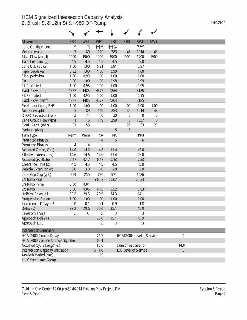
HCM Signalized Intersection Capacity Analysis2: Brush St & 12th St & I-980 Off-Ramp 2/10/2015
Oakland City Center 12:00 pm 8/14/2014 Existing Plus Project, PM Synchro 8 ReportFehr & Peers Page 2
Movement EBR WBL WBT SBT SBR SWL SWRLane ConfigurationsVolume (vph) 3 89 119 283 46 1014 43Ideal Flow (vphpl) 1900 1900 1900 1900 1900 1900 1900Total Lost time (s) 4.5 4.5 4.5 4.5 5.0Lane Util. Factor 1.00 1.00 0.91 0.91 0.97Frpb, ped/bikes 0.92 1.00 1.00 0.99 1.00Flpb, ped/bikes 1.00 0.93 1.00 1.00 1.00Frt 0.86 1.00 1.00 0.98 0.99Flt Protected 1.00 0.95 1.00 1.00 0.95Satd. Flow (prot) 1337 1485 4577 4264 3185Flt Permitted 1.00 0.95 1.00 1.00 0.95Satd. Flow (perm) 1337 1485 4577 4264 3185Peak-hour factor, PHF 1.00 1.00 1.00 1.00 1.00 1.00 1.00Adj. Flow (vph) 3 89 119 283 46 1014 43RTOR Reduction (vph) 2 74 0 30 0 0 0Lane Group Flow (vph) 1 15 119 299 0 1057 0Confl. Peds. (#/hr) 53 53 23 53 23Parking (#/hr) 5 5Turn Type Perm Perm NA NA ProtProtected Phases 4 5 6Permitted Phases 4 4Actuated Green, G (s) 14.6 14.6 14.6 11.4 45.0Effective Green, g (s) 14.6 14.6 14.6 11.4 45.0Actuated g/C Ratio 0.17 0.17 0.17 0.13 0.53Clearance Time (s) 4.5 4.5 4.5 4.5 5.0Vehicle Extension (s) 3.0 3.0 3.0 3.0 3.0Lane Grp Cap (vph) 229 255 786 571 1686v/s Ratio Prot c0.03 c0.07 c0.33v/s Ratio Perm 0.00 0.01v/c Ratio 0.00 0.06 0.15 0.52 0.63Uniform Delay, d1 29.2 29.5 29.9 34.3 14.1Progression Factor 1.00 1.00 1.00 1.00 1.00Incremental Delay, d2 0.0 0.1 0.1 0.9 1.8Delay (s) 29.2 29.6 30.0 35.1 15.9Level of Service C C C D BApproach Delay (s) 29.8 35.1 15.9Approach LOS C D B
Intersection SummaryHCM 2000 Control Delay 21.7 HCM 2000 Level of Service CHCM 2000 Volume to Capacity ratio 0.51Actuated Cycle Length (s) 85.0 Sum of lost time (s) 14.0Intersection Capacity Utilization 61.1% ICU Level of Service BAnalysis Period (min) 15c Critical Lane Group

HCM Signalized Intersection Capacity Analysis3: Broadway & 12th St 2/10/2015
Oakland City Center 12:00 pm 8/14/2014 Existing Plus Project, PM Synchro 8 ReportFehr & Peers Page 3
Movement EBL EBT EBR WBL WBT WBR NBL NBT NBR SBL SBT SBRLane ConfigurationsVolume (vph) 0 0 0 142 573 101 222 466 0 0 589 84Ideal Flow (vphpl) 1900 1900 1900 1900 1900 1900 1900 1900 1900 1900 1900 1900Total Lost time (s) 4.0 4.0 4.5 4.5Lane Util. Factor 0.91 1.00 0.95 0.95Frpb, ped/bikes 0.99 1.00 1.00 0.96Flpb, ped/bikes 0.98 1.00 1.00 1.00Frt 0.98 1.00 1.00 0.98Flt Protected 0.99 0.95 1.00 1.00Satd. Flow (prot) 4104 1450 3122 2928Flt Permitted 0.99 0.95 1.00 1.00Satd. Flow (perm) 4104 1450 3122 2928Peak-hour factor, PHF 1.00 1.00 1.00 1.00 1.00 1.00 1.00 1.00 1.00 1.00 1.00 1.00Adj. Flow (vph) 0 0 0 142 573 101 222 466 0 0 589 84RTOR Reduction (vph) 0 0 0 0 18 0 0 0 0 0 18 0Lane Group Flow (vph) 0 0 0 0 798 0 222 466 0 0 655 0Confl. Peds. (#/hr) 125 48 446 455 455 446Confl. Bikes (#/hr) 6 10 9Heavy Vehicles (%) 2% 2% 2% 2% 2% 2% 12% 2% 2% 2% 2% 2%Bus Blockages (#/hr) 0 0 0 0 10 10 0 10 0 0 10 10Parking (#/hr) 5 5 5Turn Type Perm NA Prot NA NAProtected Phases 4 5 2 6Permitted Phases 4Actuated Green, G (s) 21.0 6.0 30.5 20.5Effective Green, g (s) 21.0 6.0 30.5 20.5Actuated g/C Ratio 0.35 0.10 0.51 0.34Clearance Time (s) 4.0 4.0 4.5 4.5Lane Grp Cap (vph) 1436 145 1587 1000v/s Ratio Prot c0.15 0.15 c0.22v/s Ratio Perm 0.19v/c Ratio 0.56 1.53 0.29 0.65Uniform Delay, d1 15.7 27.0 8.5 16.7Progression Factor 1.00 1.07 0.97 1.00Incremental Delay, d2 1.6 266.5 0.4 3.3Delay (s) 17.3 295.5 8.6 20.1Level of Service B F A CApproach Delay (s) 0.0 17.3 101.2 20.1Approach LOS A B F C
Intersection SummaryHCM 2000 Control Delay 44.7 HCM 2000 Level of Service DHCM 2000 Volume to Capacity ratio 0.72Actuated Cycle Length (s) 60.0 Sum of lost time (s) 12.5Intersection Capacity Utilization 64.8% ICU Level of Service CAnalysis Period (min) 15c Critical Lane Group
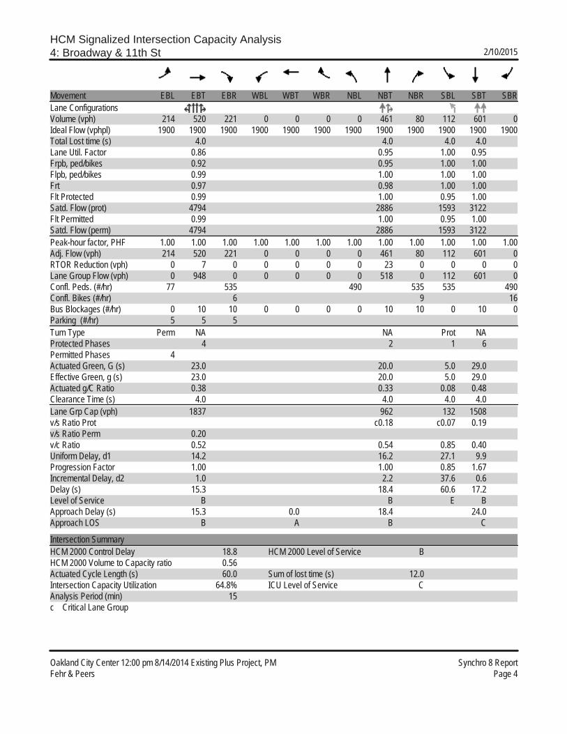
HCM Signalized Intersection Capacity Analysis4: Broadway & 11th St 2/10/2015
Oakland City Center 12:00 pm 8/14/2014 Existing Plus Project, PM Synchro 8 ReportFehr & Peers Page 4
Movement EBL EBT EBR WBL WBT WBR NBL NBT NBR SBL SBT SBRLane ConfigurationsVolume (vph) 214 520 221 0 0 0 0 461 80 112 601 0Ideal Flow (vphpl) 1900 1900 1900 1900 1900 1900 1900 1900 1900 1900 1900 1900Total Lost time (s) 4.0 4.0 4.0 4.0Lane Util. Factor 0.86 0.95 1.00 0.95Frpb, ped/bikes 0.92 0.95 1.00 1.00Flpb, ped/bikes 0.99 1.00 1.00 1.00Frt 0.97 0.98 1.00 1.00Flt Protected 0.99 1.00 0.95 1.00Satd. Flow (prot) 4794 2886 1593 3122Flt Permitted 0.99 1.00 0.95 1.00Satd. Flow (perm) 4794 2886 1593 3122Peak-hour factor, PHF 1.00 1.00 1.00 1.00 1.00 1.00 1.00 1.00 1.00 1.00 1.00 1.00Adj. Flow (vph) 214 520 221 0 0 0 0 461 80 112 601 0RTOR Reduction (vph) 0 7 0 0 0 0 0 23 0 0 0 0Lane Group Flow (vph) 0 948 0 0 0 0 0 518 0 112 601 0Confl. Peds. (#/hr) 77 535 490 535 535 490Confl. Bikes (#/hr) 6 9 16Bus Blockages (#/hr) 0 10 10 0 0 0 0 10 10 0 10 0Parking (#/hr) 5 5 5Turn Type Perm NA NA Prot NAProtected Phases 4 2 1 6Permitted Phases 4Actuated Green, G (s) 23.0 20.0 5.0 29.0Effective Green, g (s) 23.0 20.0 5.0 29.0Actuated g/C Ratio 0.38 0.33 0.08 0.48Clearance Time (s) 4.0 4.0 4.0 4.0Lane Grp Cap (vph) 1837 962 132 1508v/s Ratio Prot c0.18 c0.07 0.19v/s Ratio Perm 0.20v/c Ratio 0.52 0.54 0.85 0.40Uniform Delay, d1 14.2 16.2 27.1 9.9Progression Factor 1.00 1.00 0.85 1.67Incremental Delay, d2 1.0 2.2 37.6 0.6Delay (s) 15.3 18.4 60.6 17.2Level of Service B B E BApproach Delay (s) 15.3 0.0 18.4 24.0Approach LOS B A B C
Intersection SummaryHCM 2000 Control Delay 18.8 HCM 2000 Level of Service BHCM 2000 Volume to Capacity ratio 0.56Actuated Cycle Length (s) 60.0 Sum of lost time (s) 12.0Intersection Capacity Utilization 64.8% ICU Level of Service CAnalysis Period (min) 15c Critical Lane Group

HCM Signalized Intersection Capacity Analysis8: Broadway & 5th Street & I-880 SB On-Ramp & Alameda 2/10/2015
Oakland City Center 12:00 pm 8/14/2014 Existing Plus Project, PM Synchro 8 ReportFehr & Peers Page 8
Movement EBL2 EBL EBT EBR EBR2 NBT NBR NBR2 SBL2 SBL SBTLane ConfigurationsVolume (vph) 28 896 268 7 64 293 232 56 326 257 262Ideal Flow (vphpl) 1900 1900 1900 1900 1900 1900 1900 1900 1900 1900 1900Total Lost time (s) 4.0 4.0 4.0 4.0 4.0 3.5 4.0 4.0Lane Util. Factor 0.91 0.91 1.00 0.95 1.00 1.00 1.00 1.00Frpb, ped/bikes 1.00 1.00 0.95 1.00 0.81 1.00 1.00 1.00Flpb, ped/bikes 1.00 1.00 1.00 1.00 1.00 1.00 1.00 1.00Frt 1.00 1.00 0.85 1.00 0.85 1.00 1.00 1.00Flt Protected 0.95 0.97 1.00 1.00 1.00 0.95 0.95 1.00Satd. Flow (prot) 1449 2955 1353 3185 1149 1593 1593 1676Flt Permitted 0.95 0.97 1.00 1.00 1.00 0.95 0.95 1.00Satd. Flow (perm) 1449 2955 1353 3185 1149 1593 1593 1676Peak-hour factor, PHF 1.00 1.00 1.00 1.00 1.00 1.00 1.00 1.00 1.00 1.00 1.00Adj. Flow (vph) 28 896 268 7 64 293 232 56 326 257 262RTOR Reduction (vph) 0 0 0 0 38 0 0 0 0 0 0Lane Group Flow (vph) 0 503 696 0 26 293 288 0 326 257 262Confl. Peds. (#/hr) 26 26 71 71 71 71Confl. Bikes (#/hr) 1 1 2 2Turn Type Perm Perm NA Perm NA Perm Prot Prot NAProtected Phases 4 2 1 1 6Permitted Phases 4 4 4 2Actuated Green, G (s) 31.9 31.9 31.9 22.5 22.5 22.6 22.6 48.1Effective Green, g (s) 33.4 33.4 33.4 22.0 22.0 23.1 22.6 48.6Actuated g/C Ratio 0.37 0.37 0.37 0.24 0.24 0.26 0.25 0.54Clearance Time (s) 5.5 5.5 5.5 3.5 3.5 4.0 4.0 4.5Vehicle Extension (s) 2.0 2.0 2.0 2.0 2.0 2.0 2.0 2.0Lane Grp Cap (vph) 537 1096 502 778 280 408 400 905v/s Ratio Prot 0.09 c0.20 0.16 0.16v/s Ratio Perm c0.35 0.24 0.02 c0.25v/c Ratio 0.94 0.64 0.05 0.38 1.03 0.80 0.64 0.29Uniform Delay, d1 27.3 23.3 18.1 28.3 34.0 31.3 30.1 11.3Progression Factor 1.00 1.00 1.00 1.00 1.00 1.00 1.00 1.00Incremental Delay, d2 23.7 0.9 0.0 0.1 61.4 15.0 7.7 0.8Delay (s) 51.0 24.2 18.2 28.4 95.4 46.3 37.8 12.1Level of Service D C B C F D D BApproach Delay (s) 34.5 61.6 33.1Approach LOS C E C
Intersection SummaryHCM 2000 Control Delay 39.9 HCM 2000 Level of Service DHCM 2000 Volume to Capacity ratio 0.93Actuated Cycle Length (s) 90.0 Sum of lost time (s) 12.0Intersection Capacity Utilization 82.4% ICU Level of Service EAnalysis Period (min) 15c Critical Lane Group

HCM Signalized Intersection Capacity Analysis1: Broadway & W Grand Ave

HCM Signalized Intersection Capacity Analysis2: Brush St & 12th St & I-980 Off-Ramp

HCM Signalized Intersection Capacity Analysis3: Broadway & 12th St

HCM Signalized Intersection Capacity Analysis4: Broadway & 11th St

HCM Signalized Intersection Capacity Analysis8: 5th Street & I-880 SB On-Ramp & Broadway & Alameda

HCM Signalized Intersection Capacity Analysis1: Broadway & W Grand Ave

HCM Signalized Intersection Capacity Analysis2: Brush St & 12th St & I-980 Off-Ramp

HCM Signalized Intersection Capacity Analysis3: Broadway & 12th St
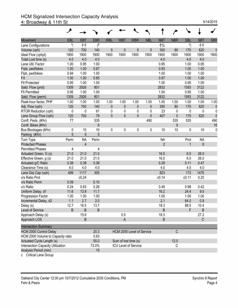
HCM Signalized Intersection Capacity Analysis4: Broadway & 11th St

HCM Signalized Intersection Capacity Analysis8: Broadway & 5th Street & I-880 SB On-Ramp & Alameda

HCM Signalized Intersection Capacity Analysis1: Broadway & W Grand Ave

HCM Signalized Intersection Capacity Analysis2: Brush St & 12th St & I-980 Off-Ramp

HCM Signalized Intersection Capacity Analysis3: Broadway & 12th St

HCM Signalized Intersection Capacity Analysis4: Broadway & 11th St

HCM Signalized Intersection Capacity Analysis8: 5th Street & I-880 SB On-Ramp & Broadway & Alameda
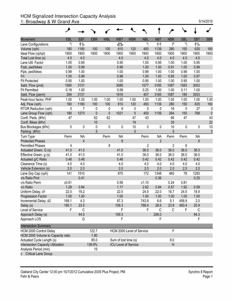
HCM Signalized Intersection Capacity Analysis1: Broadway & W Grand Ave

HCM Signalized Intersection Capacity Analysis2: Brush St & 12th St & I-980 Off-Ramp

HCM Signalized Intersection Capacity Analysis3: Broadway & 12th St

HCM Signalized Intersection Capacity Analysis4: Broadway & 11th St

HCM Signalized Intersection Capacity Analysis8: Broadway & 5th Street & I-880 SB On-Ramp & Alameda