municipal council, solan, himachal pradeshmcsolan.com/rfp 4655 gis solan.pdf · municipal council,...
TRANSCRIPT
Municipal Council, Solan, Himachal Pradesh Phone : 01792 - 223532, Email : [email protected], [email protected]
Request for Proposal (RFP) Document for Selection of Consultancy Firms for
Preparation of GIS Base Map on 1:1000 Scale and Property Survey
for Solan town of Himachal Pradesh
March 2015
EXECUTIVE OFFICER Municipal Council Solan,
Solan – 173212 HIMACHAL PRADESH
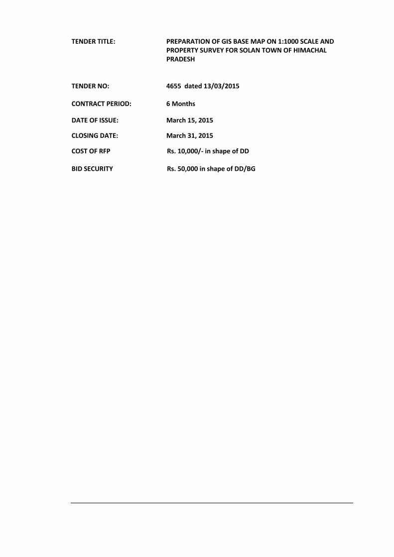
TENDER TITLE: PREPARATION OF GIS BASE MAP ON 1:1000 SCALE AND PROPERTY SURVEY FOR SOLAN TOWN OF HIMACHAL PRADESH
TENDER NO: 4655 dated 13/03/2015
CONTRACT PERIOD: 6 Months DATE OF ISSUE: March 15, 2015 CLOSING DATE: March 31, 2015 COST OF RFP Rs. 10,000/- in shape of DD BID SECURITY Rs. 50,000 in shape of DD/BG
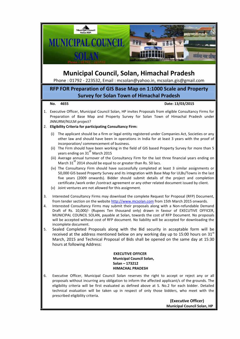
Municipal Council, Solan, Himachal Pradesh Phone : 01792 - 223532, Email : [email protected], [email protected]
RFP FOR Preparation of GIS Base Map on 1:1000 Scale and Property Survey for Solan Town of Himachal Pradesh
No. 4655 Date: 13/03/2015
1. Executive Officer, Municipal Council Solan, HP invites Proposals from eligible Consultancy Firms for
Preparation of Base Map and Property Survey for Solan Town of Himachal Pradesh under
JNNURM/NULM project?
2. Eligibility Criteria for participating Consultancy Firm:
(i) The applicant should be a firm or legal entity registered under Companies Act, Societies or any other law and should have been in operations in India for at least 3 years with the proof of incorporation/ commencement of business.
(ii) The Firm should have been working in the field of GIS based Property Survey for more than 5
years ending on 31st
March 2015 (iii) Average annual turnover of the Consultancy Firm for the last three financial years ending on
March 31st
2014 should be equal to or greater than Rs. 50 lacs. (iv) The Consultancy Firm should have successfully completed at least 3 similar assignments or
50,000 GIS based Property Survey and its integration with Base Map for ULBs/Towns in the last five years (2009 onwards). Bidder should submit details of the project and completion certificate /work order /contract agreement or any other related document issued by client.
(v) Joint ventures are not allowed for this assignment. 3. Interested Consultancy Firms may download the complete Request for Proposal (RFP) Document,
from tender section on the website http://www.mcsolan.com from 15th March 2015 onwards. 4. Interested Consultancy Firms may submit their proposals along with a Non‐refundable Demand
Draft of Rs. 10,000/‐ (Rupees Ten thousand only) drawn in favour of EXECUTIVE OFFICER, MUNICIPAL COUNCIL SOLAN, payable at Solan, towards the cost of RFP Document. No proposals will be accepted without cost of RFP document. No liability will be accepted for downloading the incomplete document.
5. Sealed Completed Proposals along with the Bid security in acceptable form will be received at the address mentioned below on any working day up to 15:00 hours on 31st March, 2015 and Technical Proposal of Bids shall be opened on the same day at 15:30 hours at following Address: EXECUTIVE OFFICER
Municipal Council Solan, Solan – 173212 HIMACHAL PRADESH
6. Executive Officer, Municipal Council Solan reserves the right to accept or reject any or all
proposals without incurring any obligation to inform the affected applicant/s of the grounds. The eligibility criteria will be first evaluated as defined above at S. No.2 for each bidder. Detailed technical evaluation will be taken up in respect of only those bidders, who meet with the prescribed eligibility criteria.
(Executive Officer) Municipal Council Solan, HP
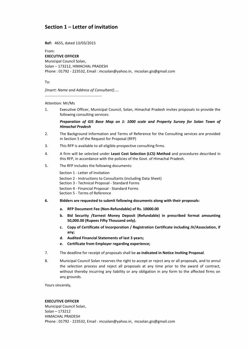
Section 1 – Letter of invitation
Ref: 4655, dated 13/03/2015 From: EXECUTIVE OFFICER Municipal Council Solan, Solan – 173212, HIMACHAL PRADESH Phone : 01792 - 223532, Email : [email protected], [email protected]
To: [Insert: Name and Address of Consultant]….. …………………………………………………… Attention: Mr/Ms 1. Executive Officer, Municipal Council, Solan, Himachal Pradesh invites proposals to provide the
following consulting services:
Preparation of GIS Base Map on 1: 1000 scale and Property Survey for Solan Town of Himachal Pradesh
2. The Background Information and Terms of Reference for the Consulting services are provided
in Section 5 of the Request for Proposal (RFP) 3. This RFP is available to all eligible prospective consulting firms. 4. A firm will be selected under Least Cost Selection (LCS) Method and procedures described in
this RFP, in accordance with the policies of the Govt. of Himachal Pradesh. 5. The RFP includes the following documents:
Section 1 - Letter of Invitation Section 2 - Instructions to Consultants (including Data Sheet) Section 3 - Technical Proposal - Standard Forms Section 4 - Financial Proposal - Standard Forms Section 5 - Terms of Reference
6. Bidders are requested to submit following documents along with their proposals:
a. RFP Document Fee (Non-Refundable) of Rs. 10000.00
b. Bid Security /Earnest Money Deposit (Refundable) in prescribed format amounting 50,000.00 (Rupees Fifty Thousand only).
c. Copy of Certificate of Incorporation / Registration Certificate including JV/Association, if
any; d. Audited Financial Statements of last 3 years; e. Certificate from Employer regarding experience;
7. The deadline for receipt of proposals shall be as indicated in Notice Inviting Proposal. 8. Municipal Council Solan reserves the right to accept or reject any or all proposals, and to annul
the selection process and reject all proposals at any time prior to the award of contract,
without thereby incurring any liability or any obligation in any form to the affected firms on
any grounds. Yours sincerely,
EXECUTIVE OFFICER Municipal Council Solan, Solan – 173212 HIMACHAL PRADESH Phone : 01792 - 223532, Email : [email protected], [email protected]

SECTION 2: INSTRUCTION TO CONSULTANTS
Section 2- INSTRUCTIONS TO CONSULTANTS
1. INTRODUCTION
General 1.1 Municipal Council, Solan, Himachal Pradesh, INDIA will select a consulting firm /organization
(the Consultant) in accordance with the method of selection specified in the Data Sheet. 1.2 Consultants should familiarize themselves with local conditions and take them into account in
preparing their Proposals. To obtain first-hand information on the assignment and local conditions, Consultants are encouraged to visit the project site.
1.3 Consultants shall bear all costs associated with the preparation and submission of their
Proposals. Costs might include site visit; collection of information; and, if selected, attendance at contract negotiations etc.
1.4 The Municipal Council, Solan is not bound to accept any Proposal and reserves the right to
annul the selection process at any time prior to contract award, without thereby incurring any liability to the Consultants.
1.5 In preparing their Proposals, Consultants are expected to examine in detail the documents
comprising the RFP. Material deficiencies in providing the information requested may result in rejection of a Proposal.
Conflict of Interest 1.6 Municipal Council, Solan requires that Consultants provide professional, objective, and impartial
advice and at all times hold the Client’s interests paramount, avoid conflicts with other
assignments or their own corporate interests and act without any consideration for future
work. Consultants shall not be recruited for any assignment that would be in conflict with their
prior or current obligations to other clients, or that may place them in a position of not being
able to carry out the assignment in the best interest of the Municipal Council, Solan. Without
limitation on the generality of the foregoing, Consultants, and any of their associates shall be
considered to have a conflict of interest and shall not be selected under any of the
circumstances set forth below:
(i) If a Consultant combines the function of consulting with those of contracting and/or
supply of equipment; or (ii) If a Consultant is associated with or affiliated to a contractor or manufacturer; or
(iii) If a Consultant is owned by a contractor or a manufacturing firm with departments or
design offices offering services as Consultants. The Consultant should include relevant
information on such relationships along with a statement in the Technical Proposal cover
letter to the effect that the Consultant will limit its role to that of a Consultant and
disqualify itself and its associates from work, in any other capacity or any future project
within the next five years, that may emerge from this assignment (including bidding or
any part of the future project). The contract with the Consultant selected to undertake
this assignment will contain an appropriate provision to such effect; or
(iv) If there is a conflict among consulting assignments, the Consultant (including its
personnel and sub-consultants) and any subsidiaries or entities controlled by such
Consultant shall not be recruited for the relevant assignment. The duties of the
Consultant depend on the circumstances of each case. While continuity of consulting
services may be appropriate in particular situations if no conflict exist, a Consultant
cannot be recruited to carry out an assignment that, by its nature, will result in conflict
with another assignment of such Consultant. For example, a Consultant engaged to
prepare engineering design for an infrastructure project shall not be recruited to prepare
an independent environmental assessment for the same project; similarly, a Consultant assisting a client in privatization of public assets shall not purchase, nor advise purchasers of, such assets or a Consultant hired to prepare terms of reference for an assignment shall not be recruited for the assignment in question.
Fraud and Corruption 1.7 The Municipal Council, Solan requires that consultants observe the highest standard of ethics
during the procurement and execution of such contracts. In such pursuance of this policy, the Municipal Council, Solan:
(i) defines, for the purposes of this provision, the terms set forth below as follows:
(a) “corrupt practice” means behaviour on the part of officials in the public or private
sectors by which they improperly and unlawfully enrich themselves and/or those close to them, or induce others to do so, by misusing the position in which they are placed, and it includes the offering, giving, receiving, or soliciting of anything of value to influence the action of any such official in the procurement process or in contract execution; and
(b) “fraudulent practice” means a misrepresentation of facts in order to influence a
procurement process or the execution of a contract to the detriment of the borrower, and includes collusive practices among bidders (prior to or after bid submission) designed to establish bid prices at artificial, non-competitive levels and to deprive the borrower of the benefits of free and open competition).
(ii) will reject a Proposal for award if it determines that the bidder recommended for award
has engaged in corrupt or fraudulent practices in competing for the contract; and
(iii) will declare a firm ineligible, either indefinitely or for a stated period of time, to be awarded any Municipal Council, Solan contract if it at any time determines that the firm has engaged in corrupt or fraudulent practices in competing for, or in executing, any Municipal Council, Solan contract.
Proposal: 1.8 If a Consultant (including a partner in any Joint Venture) submits or participates in more than
one proposal, such proposals shall be disqualified. However, this does not limit the inclusion of a Sub-Consultant, including individual experts, in more than one proposal.
Proposal Validity 1.9 The Data Sheet indicates how long the Consultants’ Proposals must remain valid after the
submission date. During this period, the Consultants shall maintain the availability of experts
nominated in the Proposal. The Client will make its best effort to complete negotiations within
this period. In case of need, the Client may request Consultants to extend the validity period of
their Proposals. Consultants have the right to refuse to extend the validity period of their
Proposals. Participation of Government Employees 1.10 No current government employee shall be deployed by the consultant without the prior written
approval by the appropriate authority. 1.11 Bid Security (Earnest Money Deposit)
a. The bid security of amount indicated in Data Sheet in the form of DD or Banker's Cheque, or Fixed Deposit Receipt, or Bank Guarantee in favour of “Executive Officer, Municipal Council, Solan” payable at Solan from any of the commercial banks in an acceptable form. The bid security is to remain valid for a period of Ninety (90) days beyond the final bid validity period.
b. The Employer shall reject any bid not accompanied by appropriate bid security, as non-
responsive.
c. The bid security of the successful Bidder shall be returned as promptly as possible once he has signed the Contract and furnished the required performance security.
d. Bid securities of the unsuccessful bidders shall be returned to them at the earliest after
expiry of the final bid validity and latest on or before the 30th day after the award of the contract to successful bidder.
e. The bid security may be forfeited:
(a) if a Bidder withdraws its bid during the period of bid validity. (b) if the successful Bidder fails to:
(i) sign the Contract within required time frame; (ii) Furnish a performance security.
2. CLARIFICATIONS AND AMENDMENTS TO RFP DOCUMENTS 2.1 Consultants may request a clarification of any of the RFP documents up to seven (7) days prior
to the Proposal submission date indicated in the Data Sheet. Any request for clarification must be sent in writing to the address indicated in the Data Sheet. The Client will respond in writing and will send written copies of the response, including an explanation of the query but without identifying the source of inquiry, to all Consultants. Should the Client deem it necessary to amend the RFP as a result of a clarification, it shall do so following the procedure under Sub-Clause 2.2.
2.2 At any time before the submission of Proposals, the Client may, whether at its own initiative, or
in response to a clarification requested by a firm, amend the RFP by issuing an addendum. The addendum shall be sent to all Consultants and will be binding on them. To give Consultants reasonable time in which to take an amendment into account in their Proposals, the Client may at its discretion, if the amendment is substantial, extend the deadline for the RFP submission.
3. PREPARATION OF THE PROPOSAL 3.1 Consultant’s Proposal (the Proposal) will consist of three (3) components
(i) Bid Security (ii) the Technical Proposal, and (ii) the Financial Proposal
3.2 Bid Security: Bid security as mentioned in clause no 1.11 above shall be placed in Envelope I. If
the bid security is found proper then only technical and financial proposals will be entertained 3.3 The Proposal, as well as all related correspondence exchanged by the Consultants and the
Client, shall be in English. All reports prepared by the contracted Consultant shall also be in English.
3.4 The Proposal should include a cover letter signed by person(s) with full authorization to make
legally binding contractual (including financial) commitments on behalf of the firm. The letter should specify all association arrangements, and certify that each associated firm will perform its designated tasks under the assignment if the lead firm is awarded the contract.
3.5 The Technical Proposal should clearly demonstrate the Consultant’s understanding of the
assignment requirements and capability and approach for carrying out the tasks set forth in the TOR through the nominated experts.
4. THE TECHNICAL PROPOSAL General 4.1 The Technical Proposal shall not include any information related to financial proposal and any
Technical Proposals containing information related to financial proposal shall be declared non-
responsive.
Technical Proposal Format 4.2 (i) The consultant shall submit technical proposal as per the data sheet which indicates the
format of the Technical Proposal to be used for the assignment. Submission of the wrong type of Technical Proposal will result in the Proposal being deemed non-responsive.
Technical Proposal Content
4.3 The Technical Proposal shall contain information indicated in the following paragraphs from (i)
to (xiii) using the Standard Technical Proposal Forms (Form TECH-1 to Form TECH-7). Such information must be provided by the Consultant and each Associate.
(i) A brief description of the organization and outline of recent experience of the consultant
and each associate on assignments of a similar nature is required in prescribed form. For each assignment, the outline should indicate inter-alia, the assignment, contract amount and the consultant’s involvement. Information should be provided only for those assignments for which the consultant was legally contracted by the client as a corporate entity or as one of the major participating consulting firms within an association (Joint venture). In case the assignment was carried out in joint venture then the JV agreement is to be submitted. Assignments completed by individual experts working privately or through other consulting firms cannot be claimed as the experience of the Consultant, or that of the Consultant’s Associate(s), but can be claimed by the individuals themselves in their CVs. Consultants should be prepared to substantiate the claimed experience if so requested by the Client.
(ii) A concise, complete, and logical description of how the Consultant’s team will carry out
the services to meet all requirements of the TOR.
(iii) A work plan showing in graphical format (bar chart) the timing of major activities, anticipated coordination meetings, and deliverables such as reports required under the TOR.
(iv) An organization chart indicating relationships amongst the Consultant and any
Associate(s), the Client, and other parties or stakeholders, if any, involved in the assignment.
(v) Comments, if any, on the TOR to improve performance in carrying out the assignment.
Innovativeness will be appreciated, including workable suggestions that could improve the quality/effectiveness of the assignment. In this regard, unless the Consultant clearly states otherwise, it will be assumed by the Client that work required to implement any such improvements, are included in the inputs shown on the Consultant’s Staffing Schedule.
(vi) The Technical Proposal shall not include information related to financial proposal.
Technical Proposals containing information related to financial proposal shall be declared non responsive.
Personnel
(vii) The name, age, background employment record, and professional experience of each nominated expert, with particular reference to the type of experience required for the services should be presented in the prescribed CV format.
(viii) Only one CV may be submitted for each position.
(ix) Higher rating will be given to nominated experts from the consulting firm and associated
consulting firms, if any, who are regular full-time employees. The Client defines a regular full-time employee to be a person who has been employed continuously by the Consultant or one of its Associates, for more than twelve (12) months prior to the date of submission of the Proposal.
(x) The Client requires that each expert confirm that the content of his/her curriculum vitae
(CV) is correct and the experts themselves should sign the certification of the CV. Note that the need to provide address and fax/e-mail details of experts in the CVs of the experts is not considered mandatory.
(xi) A zero rating will be given to a nominated expert if the expert:
(a) has not signed the cv; or
(b) is a current employee of the executing agency.

5. FINANCIAL PROPOSAL 5.1 All information provided in Consultants’ Financial Proposal will be treated as confidential. 5.2 The Financial Proposal is to be submitted in the requisite forms enclosed. 5.3 No proposed schedule of payments should be included in Consultants’ Financial Proposals. 5.4 Consultants shall quote the rates in Indian National Rupees only. 5.5 Form FIN-2 is an acknowledgement that, in preparation and submission of the Technical and
Financial Proposals, Consultants have:
(i) not taken any action which is or constitutes a corrupt or fraudulent practice; and (ii) agreed to allow the Client, at their option, to inspect and audit all accounts,
documents, and records relating to the Consultant’s Proposal and to the performance of the ensuring Consultant’s Contract.
5.6 The rates to be quoted shall be in the format given in Data Sheet and it shall include all costs /
expenses and statutory taxes excluding Service Tax. The Client shall pay Service Tax as applicable on prevailing rates.
6. SUBMISSION, RECEIPT AND OPENING OF PROPOSALS 6.1 The original Proposal (Earnest Money Deposit, Technical and Financial Proposals) shall contain
no interlineations or overwriting, except as necessary to correct errors made by Consultants themselves. Any such corrections, interlineations or overwriting must be initialed by the person(s) who signed the Proposal.
6.2 An authorized representative of the Consultant shall initial all pages of the original copy of the
Financial Proposal. No other copies are required. 6.3 The Technical Proposal shall be marked “ORIGINAL” or “COPY” as appropriate. All required
copies of the Technical Proposal as specified in the Data Sheet will be made from the original. If there are discrepancies between the original and the copies of the Technical Proposal, the original governs.
6.4 The original and all copies of the Technical Proposal to be sent to the Client shall be placed in a
sealed envelope clearly marked “TECHNICAL PROPOSAL.” Similarly, the original Financial Proposal shall be placed in a sealed envelope clearly marked “FINANCIAL PROPOSAL” and with a warning “DO NOT OPEN WITH THE TECHNICAL PROPOSAL.” The envelopes (Envelope 1 –
Earnest Money Deposit, Envelope 2 –Technical and Envelope 3 –Financial Proposals) shall be placed into an outer envelope and sealed. The outer envelope shall bear the submission address, reference number, and other information indicated in the Data Sheet. If the Financial Proposal is not submitted by the Consultant in a separate sealed envelope and duly marked as indicated above, this will constitute grounds for declaring both Technical and Financial Proposals non-responsive.
6.5 Proposals must be delivered at the indicated Client submission addresses on or before the time
and date stated in the Data Sheet or any new date established by the Client according to provisions of Sub-Clause 2.2.
7. PROPOSAL EVALUATION General 7.1 From the time the Proposals are opened to the time the contract is awarded, the Consultant
should not contact the Client on any matter related to its Technical and/or Financial Proposal. Any effort by a Consultant to influence the Client in examination, evaluation, ranking of Proposals or recommendation for award of contract may result in rejection of the Consultant’s Proposal.
7.2 The envelope 1 shall be opened first. If the bid security is not found to be in order then the
proposal shall be treated as non-responsive and shall not be evaluated further.
Evaluation of Technical Proposals 7.3 The eligibility criteria will be first evaluated as defined in Notice Inviting Request for Proposals
for each bidder. Detailed technical evaluation will be taken up in respect of only those bidders, who meet with the prescribed eligibility criteria.
7.4 The Client’s ‘Consultants Selection Committee’ (CSC) will be responsible for evaluation and
ranking of Proposals received. 7.5 The CSC evaluates and ranks the Technical Proposals on the basis of Proposal’s responsiveness
to the TOR using the evaluation criteria and points system specified in the Data Sheet. Each Technical Proposal will receive a technical score. A Proposal shall be rejected if it does not achieve the minimum technical mark of 750 from the maximum of 1000 points.
7.6 A Technical Proposal may not be considered for evaluation in any of the following cases:
(i) the Consultant that submitted the Proposal or one of its Associated Consultants belongs to one of the cases described in Sub-Clause 5.6(i) to and failed to make a proper statement to that effect in the cover letter ; or
(ii) the Consultant that submitted the Proposal or one of its Associated Consultants was found
not to be legally incorporated or established in India; or (iii) the Technical Proposal was submitted in the wrong format; (iv) the Technical Proposal included details of costs of the services; or
(v) the Technical Proposal reached the Client after the submission closing time and date
specified in the Data Sheet. 7.7 After the technical evaluation is completed, the Client shall notify Consultants whose Proposals
did not meet the minimum qualifying technical mark or Consultants whose Technical Proposals
were considered non-responsive to the RFP requirements, indicating that their Financial
Proposals will be returned unopened after completion of the selection process. The Client shall
simultaneously notify, in writing Consultants whose Technical Proposals received a mark of 750
or higher, indicating the date, time, and location for opening of Financial Proposals. (Consultants’ attendance at the opening of Financial Proposals is optional).
8. PUBLIC OPENING AND EVALUATION OF FINANCIAL PROPOSALS
Public Opening of Financial Proposals 8.1 At the public opening of Financial Proposals, Consultant representatives who choose to attend,
will sign an Attendance Sheet.
(i) The marks of each Technical Proposal that met the minimum mark of 750 will be read out
aloud.
(ii) Each Financial Proposal will be checked to confirm that it has remained sealed and
unopened.
(iii) The Client’s representative will open each Financial Proposal. Such representative will read out aloud the name of the Consultant and the total price shown in the Consultant’s Financial Proposal. This information will be recorded in writing by the Client’s representative.
Evaluation of Financial Proposals
8.2 Following the ranking of Technical Proposals, financial proposals shall be opened publicly and
read out; and the highest ranked bidder based on cumulative technical and financial evaluation
ranking will be invited for contract negotiations. 8.3 Consultants’ attendance at the opening of Financial Proposals is optional.
8.4 The evaluation committee will review the detailed content of each Financial Proposal. During
the review of Financial Proposals, the Committee and any Client personnel and others involved
in the evaluation process, will not be permitted to seek clarification or additional information
from any Consultant, who has submitted a Financial Proposal. Financial Proposals will be
reviewed to ensure these are:
(i) complete, to see if all items of the corresponding Technical Proposal are priced; if not, for material omissions, the Client will price them by application of the highest unit cost and quantity of the omitted item as provided in the other Financial Proposals and add their cost to the offered price, and correct any arithmetical errors.
(ii) computational errors if there are errors these will be corrected;
(iii) other errors, such as activities which are shown as different time lines in technical proposal and different in financial; price for these will be based on the technical proposal.
8.5 The detailed contents of each Financial Proposal will be subsequently reviewed by the Client. 8.6 Tthe LCS method is used: the Client will select the lowest Financial Proposal of a Consultant
whose Technical Proposal has qualified. The lowest evaluated Financial Proposal will receive
the maximum score of 100 marks. 9. Contract Negotiations and Award of Contract 9.1 The Consultant who is invited for contract negotiations will, as a pre-requisite for attendance
at the negotiations, confirm availability of all experts named in its proposal except in the cases of absence on account of death or medical incapacity. Failure in satisfying such requirements may result in the Client proceeding to initiate the negotiation process with the next-ranked Consultant. Representatives conducting negotiations on behalf of the Consultant must have written authority to negotiate and conclude the Contract
9.2 The selected Consultant is expected to commence the Assignment on the date and at the location specified in the Data Sheet.
10. Duration of Assignment
The duration of assignment for satisfactory performance of the services the contract will be the period defined in Data Sheet.
11. Performance Security
The consultant will furnish within 10 days of the issue of Letter of Acceptance (LOA), an unconditional Bank Guarantee in favour of Executive Officer, Municipal Council Solan from any scheduled commercial Bank for an amount equivalent to 10% of the total contract value towards Performance Security valid for a period of one year beyond the date of completion of services. The Bank Guarantee will be released after one year or completion of the project and rectification of errors if any, found during implementation of the contract for civil work and satisfactory report by supervision consultant / staff engaged by Municipal Council Solan.
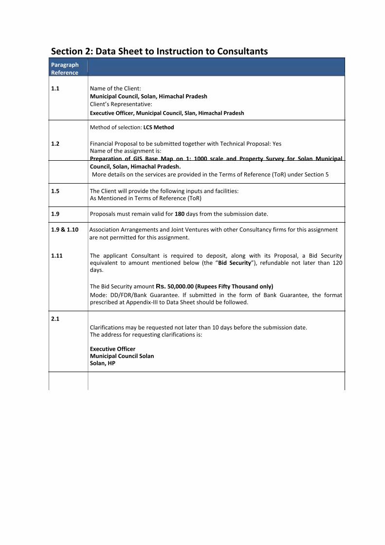
Section 2: Data Sheet to Instruction to Consultants Paragraph Reference 1.1 Name of the Client:
Municipal Council, Solan, Himachal Pradesh Client’s Representative: Executive Officer, Municipal Council, Slan, Himachal Pradesh Method of selection: LCS Method
1.2 Financial Proposal to be submitted together with Technical Proposal: Yes
Name of the assignment is: Preparation of GIS Base Map on 1: 1000 scale and Property Survey for Solan Municipal Council, Solan, Himachal Pradesh. More details on the services are provided in the Terms of Reference (ToR) under Section 5
1.5 The Client will provide the following inputs and facilities:
As Mentioned in Terms of Reference (ToR) 1.9 Proposals must remain valid for 180 days from the submission date. 1.9 & 1.10 Association Arrangements and Joint Ventures with other Consultancy firms for this assignment are not permitted for this assignment. 1.11 The applicant Consultant is required to deposit, along with its Proposal, a Bid Security
equivalent to amount mentioned below (the “Bid Security”), refundable not later than 120 days.
The Bid Security amount Rs. 50,000.00 (Rupees Fifty Thousand only) Mode: DD/FDR/Bank Guarantee. If submitted in the form of Bank Guarantee, the format prescribed at Appendix-III to Data Sheet should be followed.
2.1
Clarifications may be requested not later than 10 days before the submission date. The address for requesting clarifications is: Executive Officer Municipal Council Solan Solan, HP
Paragraph Reference
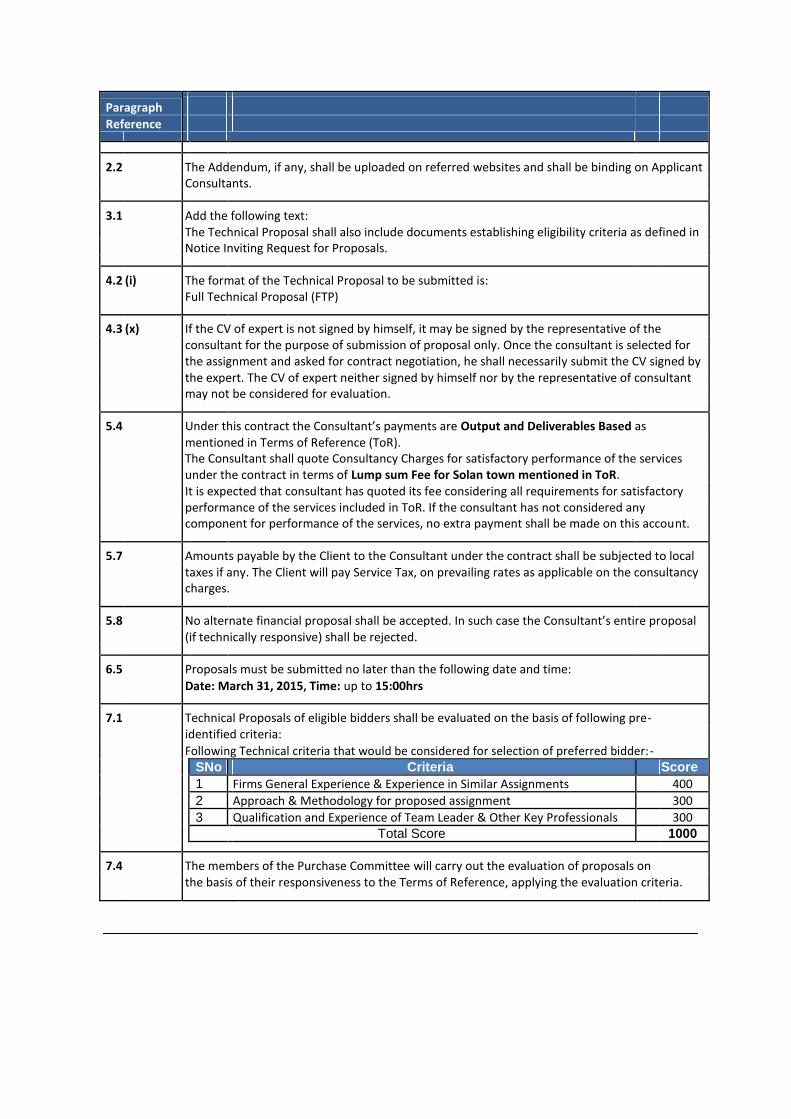
2.2 The Addendum, if any, shall be uploaded on referred websites and shall be binding on Applicant Consultants.
3.1 Add the following text: The Technical Proposal shall also include documents establishing eligibility criteria as defined in Notice Inviting Request for Proposals.
4.2 (i) The format of the Technical Proposal to be submitted is: Full Technical Proposal (FTP)
4.3 (x) If the CV of expert is not signed by himself, it may be signed by the representative of the consultant for the purpose of submission of proposal only. Once the consultant is selected for the assignment and asked for contract negotiation, he shall necessarily submit the CV signed by the expert. The CV of expert neither signed by himself nor by the representative of consultant may not be considered for evaluation.
5.4 Under this contract the Consultant’s payments are Output and Deliverables Based as mentioned in Terms of Reference (ToR).
The Consultant shall quote Consultancy Charges for satisfactory performance of the services under the contract in terms of Lump sum Fee for Solan town mentioned in ToR. It is expected that consultant has quoted its fee considering all requirements for satisfactory performance of the services included in ToR. If the consultant has not considered any component for performance of the services, no extra payment shall be made on this account.
5.7 Amounts payable by the Client to the Consultant under the contract shall be subjected to local taxes if any. The Client will pay Service Tax, on prevailing rates as applicable on the consultancy charges.
5.8 No alternate financial proposal shall be accepted. In such case the Consultant’s entire proposal (if technically responsive) shall be rejected.
6.5 Proposals must be submitted no later than the following date and time: Date: March 31, 2015, Time: up to 15:00hrs
7.1 Technical Proposals of eligible bidders shall be evaluated on the basis of following pre- identified criteria:
Following Technical criteria that would be considered for selection of preferred bidder:-
SNo Criteria Score 1 Firms General Experience & Experience in Similar Assignments 400 2 Approach & Methodology for proposed assignment 300 3 Qualification and Experience of Team Leader & Other Key Professionals 300 Total Score 1000
7.4 The members of the Purchase Committee will carry out the evaluation of proposals on the basis of their responsiveness to the Terms of Reference, applying the evaluation criteria.
Paragraph Reference
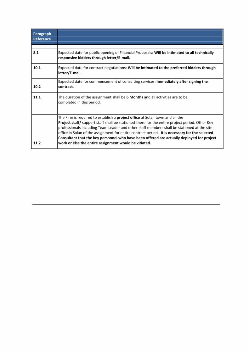
8.1 Expected date for public opening of Financial Proposals: Will be intimated to all technically responsive bidders through letter/E-mail.
10.1 Expected date for contract negotiations: Will be intimated to the preferred bidders through letter/E-mail.
10.2 Expected date for commencement of consulting services: Immediately after signing the contract.
11.1 The duration of the assignment shall be 6 Months and all activities are to be completed in this period.
11.2
The Firm is required to establish a project office at Solan town and all the Project staff/ support staff shall be stationed there for the entire project period. Other Key professionals including Team Leader and other staff members shall be stationed at the site office in Solan of the assignment for entire contract period. It is necessary for the selected Consultant that the key personnel who have been offered are actually deployed for project work or else the entire assignment would be vitiated.
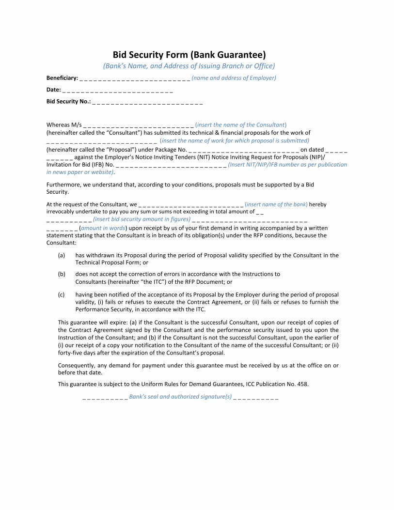
Bid Security Form (Bank Guarantee) (Bank’s Name, and Address of Issuing Branch or Office)
Beneficiary: _ _ _ _ _ _ _ _ _ _ _ _ _ _ _ _ _ _ _ _ _ _ _ _ (name and address of Employer) Date: _ _ _ _ _ _ _ _ _ _ _ _ _ _ _ _ _ _ _ _ _ _ _ _ Bid Security No.: _ _ _ _ _ _ _ _ _ _ _ _ _ _ _ _ _ _ _ _ _ _ _ _ Whereas M/s _ _ _ _ _ _ _ _ _ _ _ _ _ _ _ _ _ _ _ _ _ _ _ _ (insert the name of the Consultant) (hereinafter called the “Consultant”) has submitted its technical & financial proposals for the work of _ _ _ _ _ _ _ _ _ _ _ _ _ _ _ _ _ _ _ _ _ _ _ _ (insert the name of work for which proposal is submitted) (hereinafter called the “Proposal”) under Package No. _ _ _ _ _ _ _ _ _ _ _ _ _ _ _ _ _ _ _ _ _ _ _ _ on dated _ _ _ _ _ _ _ _ _ _ _ against the Employer’s Notice Inviting Tenders (NIT) Notice Inviting Request for Proposals (NIP)/ Invitation for Bid (IFB) No. _ _ _ _ _ _ _ _ _ _ _ _ _ _ _ _ _ _ _ _ _ _ _ _ (Insert NIT/NIP/IFB number as per publication in news paper or website). Furthermore, we understand that, according to your conditions, proposals must be supported by a Bid Security. At the request of the Consultant, we _ _ _ _ _ _ _ _ _ _ _ _ _ _ _ _ _ _ _ _ _ _ _ _ (insert name of the bank) hereby irrevocably undertake to pay you any sum or sums not exceeding in total amount of _ _ _ _ _ _ _ _ _ _ _ _ (insert bid security amount in figures) _ _ _ _ _ _ _ _ _ _ _ _ _ _ _ _ _ _ _ _ _ _ _ _ _ _ _ _ _ _ _ _ (amount in words) upon receipt by us of your first demand in writing accompanied by a written statement stating that the Consultant is in breach of its obligation(s) under the RFP conditions, because the Consultant:
(a) has withdrawn its Proposal during the period of Proposal validity specified by the Consultant in the Technical Proposal Form; or
(b) does not accept the correction of errors in accordance with the Instructions to
Consultants (hereinafter “the ITC”) of the RFP Document; or
(c) having been notified of the acceptance of its Proposal by the Employer during the period of proposal validity, (i) fails or refuses to execute the Contract Agreement, or (ii) fails or refuses to furnish the Performance Security, in accordance with the ITC.
This guarantee will expire: (a) if the Consultant is the successful Consultant, upon our receipt of copies of the Contract Agreement signed by the Consultant and the performance security issued to you upon the Instruction of the Consultant; and (b) if the Consultant is not the successful Consultant, upon the earlier of (i) our receipt of a copy your notification to the Consultant of the name of the successful Consultant; or (ii) forty-five days after the expiration of the Consultant’s proposal.
Consequently, any demand for payment under this guarantee must be received by us at the office on or before that date.
This guarantee is subject to the Uniform Rules for Demand Guarantees, ICC Publication No. 458.
_ _ _ _ _ _ _ _ _ _ Bank’s seal and authorized signature(s) _ _ _ _ _ _ _ _ _ _

SECTION 3: TECHNICAL FORMS
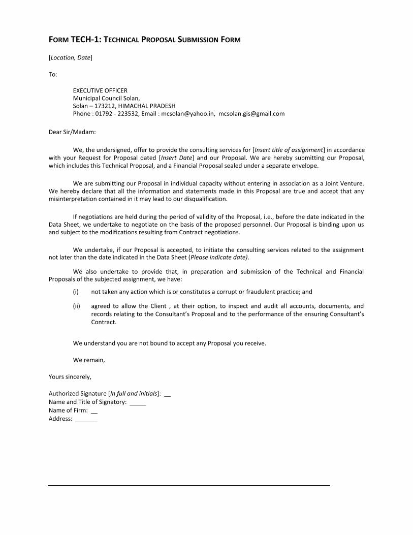
FORM TECH-1: TECHNICAL PROPOSAL SUBMISSION FORM
[Location, Date] To:
EXECUTIVE OFFICER Municipal Council Solan, Solan – 173212, HIMACHAL PRADESH Phone : 01792 - 223532, Email : [email protected], [email protected]
Dear Sir/Madam:
We, the undersigned, offer to provide the consulting services for [Insert title of assignment] in accordance
with your Request for Proposal dated [Insert Date] and our Proposal. We are hereby submitting our Proposal, which includes this Technical Proposal, and a Financial Proposal sealed under a separate envelope.
We are submitting our Proposal in individual capacity without entering in association as a Joint Venture.
We hereby declare that all the information and statements made in this Proposal are true and accept that any misinterpretation contained in it may lead to our disqualification.
If negotiations are held during the period of validity of the Proposal, i.e., before the date indicated in the
Data Sheet, we undertake to negotiate on the basis of the proposed personnel. Our Proposal is binding upon us and subject to the modifications resulting from Contract negotiations.
We undertake, if our Proposal is accepted, to initiate the consulting services related to the assignment
not later than the date indicated in the Data Sheet (Please indicate date).
We also undertake to provide that, in preparation and submission of the Technical and Financial Proposals of the subjected assignment, we have:
(i) not taken any action which is or constitutes a corrupt or fraudulent practice; and
(ii) agreed to allow the Client , at their option, to inspect and audit all accounts, documents, and records relating to the Consultant’s Proposal and to the performance of the ensuring Consultant’s Contract.
We understand you are not bound to accept any Proposal you receive.
We remain,
Yours sincerely, Authorized Signature [In full and initials]: Name and Title of Signatory: Name of Firm: Address:
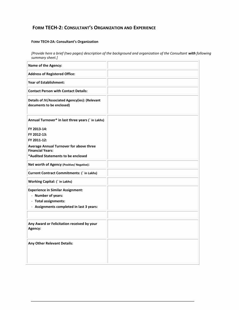
FORM TECH-2: CONSULTANT’S ORGANIZATION AND EXPERIENCE
FORM TECH-2A: Consultant’s Organization
[Provide here a brief (two pages) description of the background and organization of the Consultant with following summary sheet.]
Name of the Agency: Address of Registered Office: Year of Establishment: Contact Person with Contact Details: Details of JV/Associated Agency(ies): (Relevant
documents to be enclosed)
Annual Turnover* in last three years (` in Lakhs) FY 2013-14: FY 2012-13: FY 2011-12: Average Annual Turnover for above three Financial Years: *Audited Statements to be enclosed Net worth of Agency (Positive/ Negative): Current Contract Commitments: (` in Lakhs) Working Capital: (` in Lakhs) Experience in Similar Assignment:
- Number of years: - Total assignments: - Assignments completed in last 3 years:
Any Award or Felicitation received by your Agency:
Any Other Relevant Details:
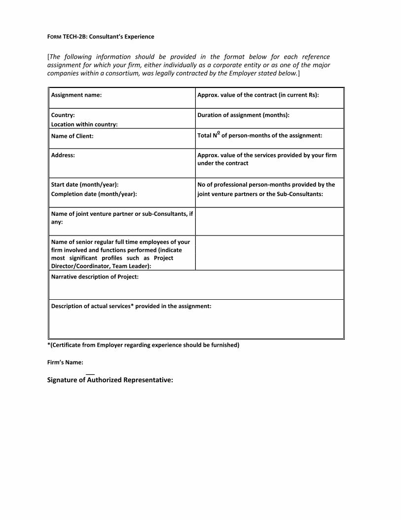
FORM TECH-2B: Consultant’s Experience
[The following information should be provided in the format below for each reference assignment for which your firm, either individually as a corporate entity or as one of the major companies within a consortium, was legally contracted by the Employer stated below.]
Assignment name: Approx. value of the contract (in current Rs):
Country: Duration of assignment (months):
Location within country:
Name of Client: Total No of person-months of the assignment:
Address: Approx. value of the services provided by your firm under the contract
Start date (month/year): No of professional person-months provided by the
Completion date (month/year): joint venture partners or the Sub-Consultants:
Name of joint venture partner or sub-Consultants, if any:
Name of senior regular full time employees of your firm involved and functions performed (indicate
most significant profiles such as Project
Director/Coordinator, Team Leader):
Narrative description of Project:
Description of actual services* provided in the assignment:
*(Certificate from Employer regarding experience should be furnished) Firm’s Name: Signature of Authorized Representative:
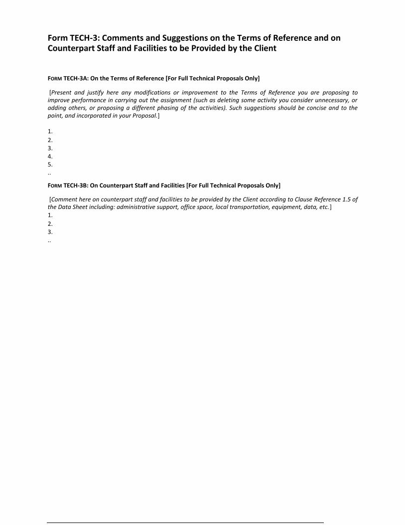
Form TECH-3: Comments and Suggestions on the Terms of Reference and on Counterpart Staff and Facilities to be Provided by the Client FORM TECH-3A: On the Terms of Reference [For Full Technical Proposals Only] [Present and justify here any modifications or improvement to the Terms of Reference you are proposing to
improve performance in carrying out the assignment (such as deleting some activity you consider unnecessary, or adding others, or proposing a different phasing of the activities). Such suggestions should be concise and to the point, and incorporated in your Proposal.] 1. 2. 3. 4. 5. .. FORM TECH-3B: On Counterpart Staff and Facilities [For Full Technical Proposals Only] [Comment here on counterpart staff and facilities to be provided by the Client according to Clause Reference 1.5 of
the Data Sheet including: administrative support, office space, local transportation, equipment, data, etc.] 1. 2. 3. ..
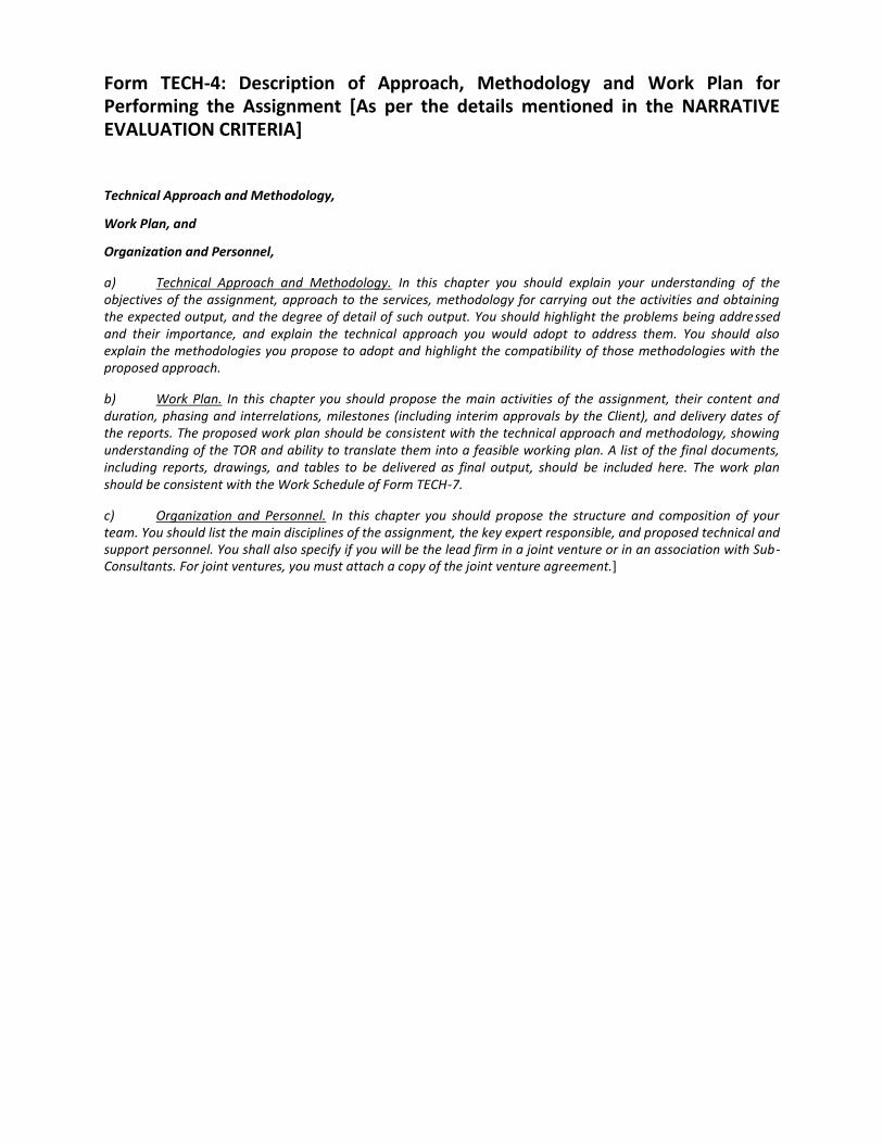
Form TECH-4: Description of Approach, Methodology and Work Plan for Performing the Assignment [As per the details mentioned in the NARRATIVE EVALUATION CRITERIA] Technical Approach and Methodology, Work Plan, and Organization and Personnel, a) Technical Approach and Methodology. In this chapter you should explain your understanding of the objectives of the assignment, approach to the services, methodology for carrying out the activities and obtaining the expected output, and the degree of detail of such output. You should highlight the problems being addressed and their importance, and explain the technical approach you would adopt to address them. You should also explain the methodologies you propose to adopt and highlight the compatibility of those methodologies with the proposed approach. b) Work Plan. In this chapter you should propose the main activities of the assignment, their content and duration, phasing and interrelations, milestones (including interim approvals by the Client), and delivery dates of the reports. The proposed work plan should be consistent with the technical approach and methodology, showing understanding of the TOR and ability to translate them into a feasible working plan. A list of the final documents, including reports, drawings, and tables to be delivered as final output, should be included here. The work plan should be consistent with the Work Schedule of Form TECH-7. c) Organization and Personnel. In this chapter you should propose the structure and composition of your team. You should list the main disciplines of the assignment, the key expert responsible, and proposed technical and support personnel. You shall also specify if you will be the lead firm in a joint venture or in an association with Sub-Consultants. For joint ventures, you must attach a copy of the joint venture agreement.]
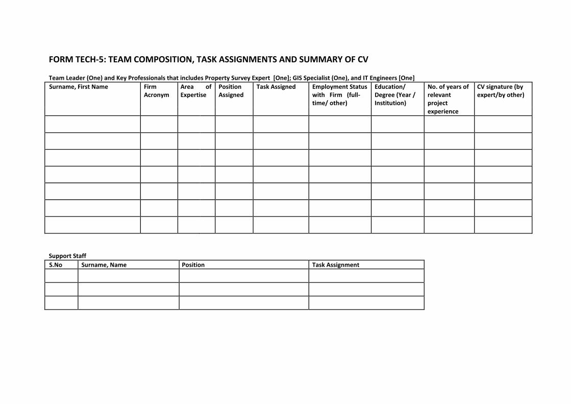
FORM TECH-5: TEAM COMPOSITION, TASK ASSIGNMENTS AND SUMMARY OF CV Team Leader (One) and Key Professionals that includes Property Survey Expert [One]; GIS Specialist (One), and IT Engineers [One] Surname, First Name Firm Area of Position Task Assigned Employment Status Education/ No. of years of CV signature (by
Acronym Expertise Assigned with Firm (full- Degree (Year / relevant expert/by other) time/ other) Institution) project
experience
Support Staff S.No Surname, Name Position Task Assignment
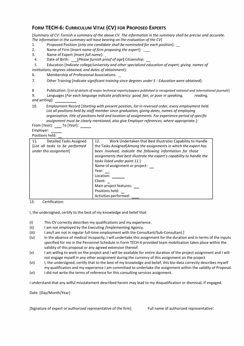
FORM TECH-6: CURRICULUM VITAE (CV) FOR PROPOSED EXPERTS
[Summary of CV: Furnish a summary of the above CV. The information in the summary shall be precise and accurate. The information in the summary will have bearing on the evaluation of the CV] 1. Proposed Position [only one candidate shall be nominated for each position]: 2. Name of Firm [Insert name of firm proposing the expert]: 3. Name of Expert [Insert full name]:
4. Date of Birth: (Please furnish proof of age) Citizenship:
5. Education [Indicate college/university and other specialized education of expert, giving names of institutions, degrees obtained, and dates of obtainment]: 6. Membership of Professional Associations: 7. Other Training [Indicate significant training since degrees under 5 - Education were obtained]:
8 Publication: [List of details of major technical reports/papers published in recognized national and international journals] 9. Languages [For each language indicate proficiency: good, fair, or poor in speaking, reading, and writing]:
10. Employment Record [Starting with present position, list in reversed order, every employment held.
List all positions held by staff member since graduation, giving dates, names of employing organization, title of positions held and location of assignments. For experience period of specific assignment must be clearly mentioned, also give Employer references, where appropriate.]:
From [Year]: To [Year]:
Employer:
Positions held:
11. Detailed Tasks Assigned 12. Work Undertaken that Best Illustrates Capability to Handle [List all tasks to be performed the Tasks Assigned[Among the assignments in which the expert has under this assignment] been involved, indicate the following information for those
assignments that best illustrate the expert’s capability to handle the tasks listed under point 11.] Name of assignment or project: Year:
Location: Client:
Main project features:
Positions held:
Activities performed:
13. Certification:
I, the undersigned, certify to the best of my knowledge and belief that: (i) This CV correctly describes my qualifications and my experience. (ii) I am not employed by the Executing /Implementing Agency. (iii) I am/I am not in regular full-time employment with the Consultant/Sub-Consultant.] (iv) In the absence of medical incapacity, I will undertake this assignment for the duration and in terms of the inputs specified for me in the Personnel Schedule in Form TECH-6 provided team mobilization takes place within the validity of this proposal or any agreed extension thereof. (v) I am willing to work on the project and I will be available for entire duration of the project assignment and I will not engage myself in any other assignment during the currency of this assignment on the project (vi) I, the undersigned, certify that to the best of my knowledge and belief, this bio-data correctly describes myself my qualification and my experience I am committed to undertake the assignment within the validity of Proposal. (vi) I did not write the terms of reference for this consulting services assignment. I understand that any wilful misstatement described herein may lead to my disqualification or dismissal, if engaged. Date: [Day/Month/Year]
[Signature of expert or authorized representative of the firm] Full name of authorized representative:
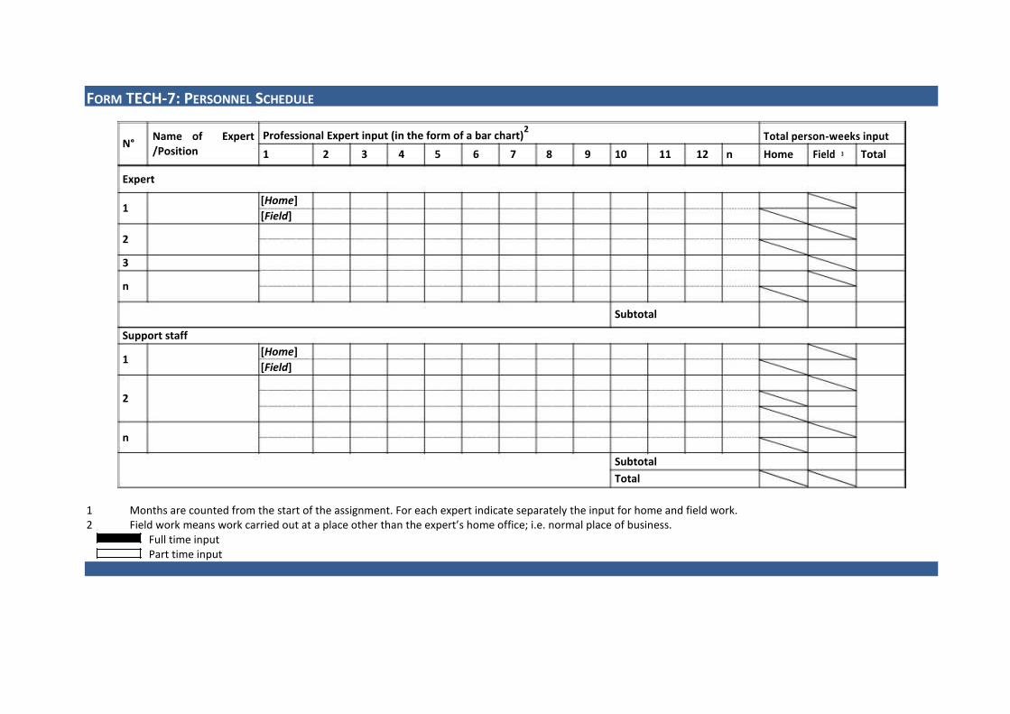
FORM TECH-7: PERSONNEL SCHEDULE
N° Name of Expert Professional Expert input (in the form of a bar chart)
2 Total person-weeks input
/Position
1 2 3 4 5 6 7 8 9 10 11 12 n Home Field 3 Total
Expert
1 [Home]
[Field]
2
3
n
Subtotal
Support staff
1 [Home]
[Field]
2
n
Subtotal
Total
1 Months are counted from the start of the assignment. For each expert indicate separately the input for home and field work. 2 Field work means work carried out at a place other than the expert’s home office; i.e. normal place of business.
Full time input Part time input
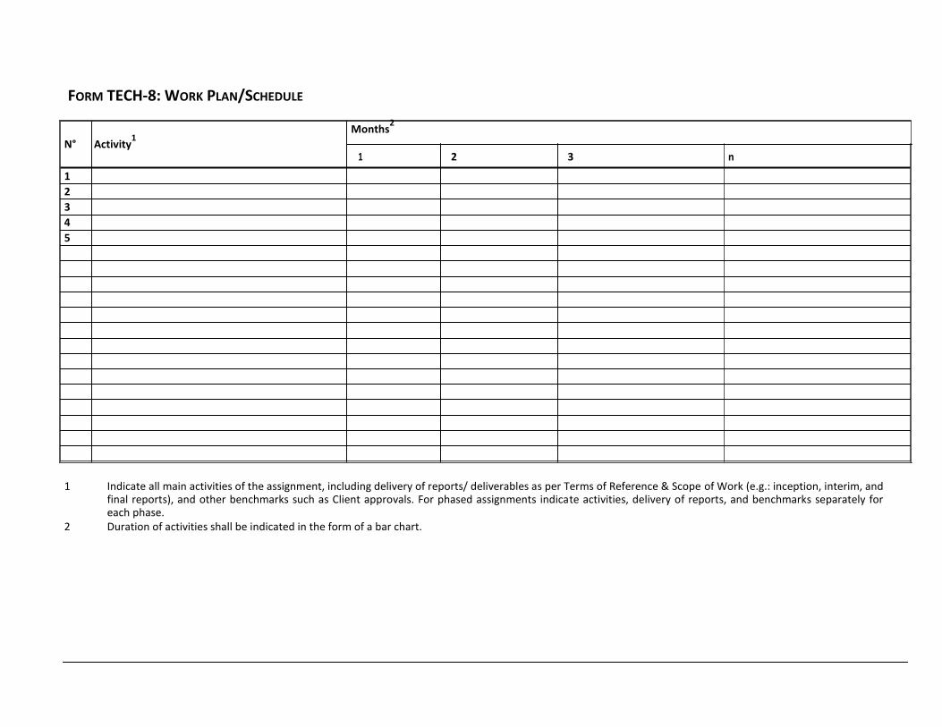
FORM TECH-8: WORK PLAN/SCHEDULE
Months2
N° Activity1
1 2 3 n 1 2 3 4 5
1 Indicate all main activities of the assignment, including delivery of reports/ deliverables as per Terms of Reference & Scope of Work (e.g.: inception, interim, and final reports), and other benchmarks such as Client approvals. For phased assignments indicate activities, delivery of reports, and benchmarks separately for each phase. 2 Duration of activities shall be indicated in the form of a bar chart.

SECTION 4: FINANCIAL PROPOSAL
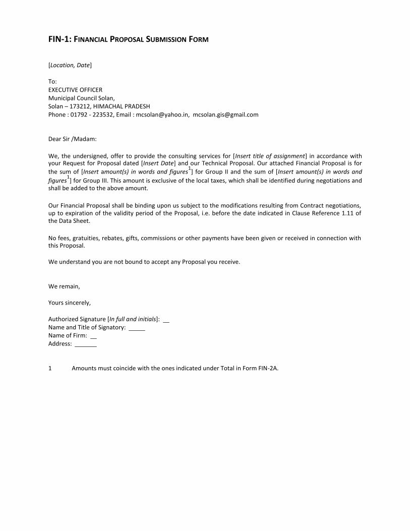
FIN-1: FINANCIAL PROPOSAL SUBMISSION FORM [Location, Date] To: EXECUTIVE OFFICER Municipal Council Solan, Solan – 173212, HIMACHAL PRADESH Phone : 01792 - 223532, Email : [email protected], [email protected] Dear Sir /Madam:
We, the undersigned, offer to provide the consulting services for [Insert title of assignment] in accordance with your Request for Proposal dated [Insert Date] and our Technical Proposal. Our attached Financial Proposal is for
the sum of [Insert amount(s) in words and figures1] for Group II and the sum of [Insert amount(s) in words and
figures1] for Group III. This amount is exclusive of the local taxes, which shall be identified during negotiations and
shall be added to the above amount.
Our Financial Proposal shall be binding upon us subject to the modifications resulting from Contract negotiations, up to expiration of the validity period of the Proposal, i.e. before the date indicated in Clause Reference 1.11 of the Data Sheet.
No fees, gratuities, rebates, gifts, commissions or other payments have been given or received in connection with this Proposal. We understand you are not bound to accept any Proposal you receive. We remain, Yours sincerely, Authorized Signature [In full and initials]: Name and Title of Signatory: Name of Firm: Address: 1 Amounts must coincide with the ones indicated under Total in Form FIN-2A.
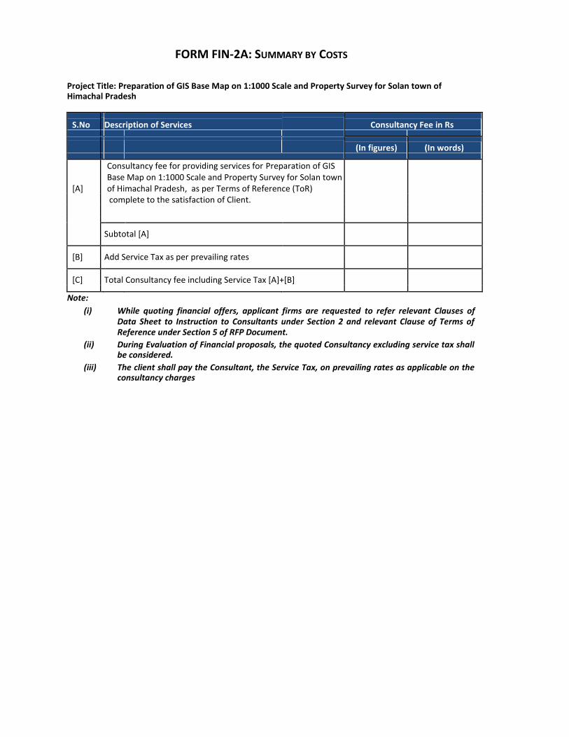
FORM FIN-2A: SUMMARY BY COSTS Project Title: Preparation of GIS Base Map on 1:1000 Scale and Property Survey for Solan town of Himachal Pradesh
S.No Description of Services Consultancy Fee in Rs
(In figures) (In words)
[A]
Consultancy fee for providing services for Preparation of GIS Base Map on 1:1000 Scale and Property Survey for Solan town of Himachal Pradesh, as per Terms of Reference (ToR)
complete to the satisfaction of Client.
Subtotal [A]
[B] Add Service Tax as per prevailing rates
[C] Total Consultancy fee including Service Tax [A]+[B]
Note: (i) While quoting financial offers, applicant firms are requested to refer relevant Clauses of
Data Sheet to Instruction to Consultants under Section 2 and relevant Clause of Terms of Reference under Section 5 of RFP Document.
(ii) During Evaluation of Financial proposals, the quoted Consultancy excluding service tax shall be considered.
(iii) The client shall pay the Consultant, the Service Tax, on prevailing rates as applicable on the consultancy charges

SECTION 5: TERMS OF REFERENCE
Section 5: Terms of Reference (ToR)
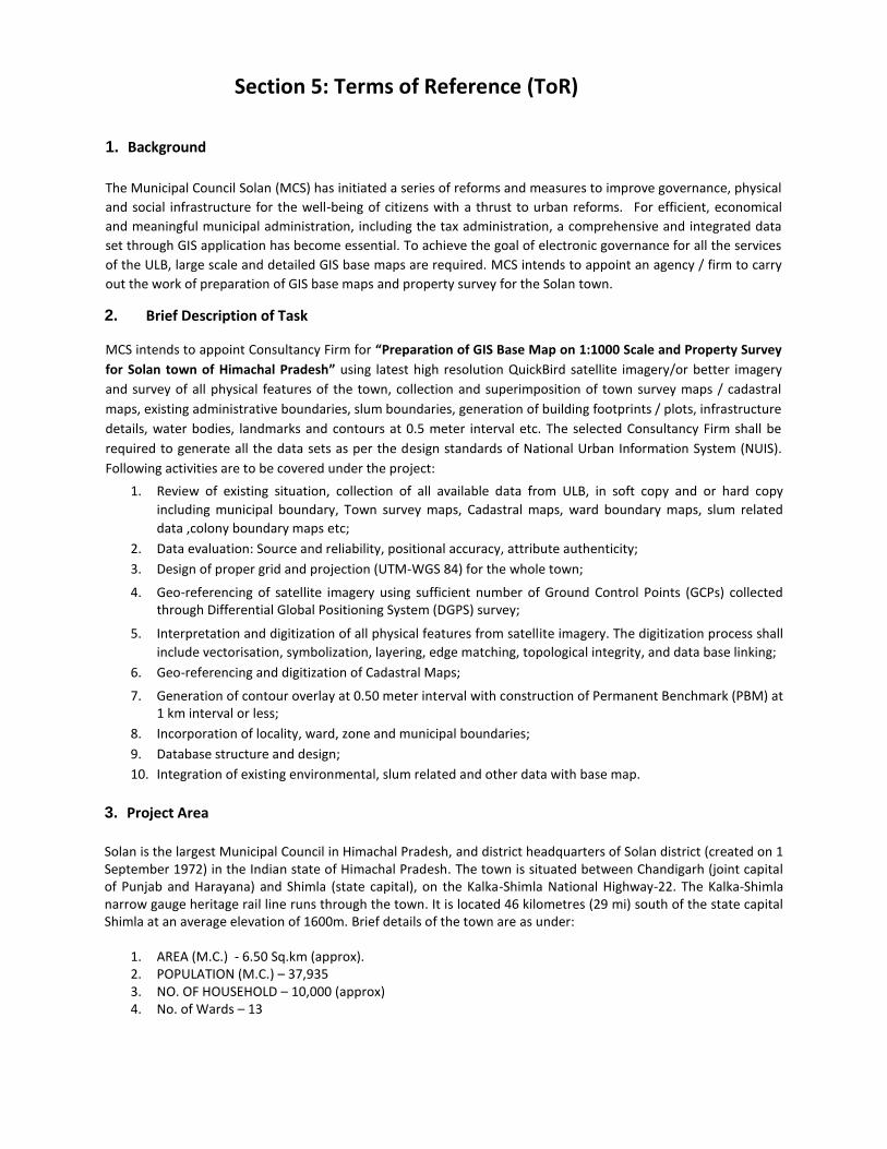
1. Background
The Municipal Council Solan (MCS) has initiated a series of reforms and measures to improve governance, physical
and social infrastructure for the well-being of citizens with a thrust to urban reforms. For efficient, economical
and meaningful municipal administration, including the tax administration, a comprehensive and integrated data
set through GIS application has become essential. To achieve the goal of electronic governance for all the services
of the ULB, large scale and detailed GIS base maps are required. MCS intends to appoint an agency / firm to carry
out the work of preparation of GIS base maps and property survey for the Solan town. 2. Brief Description of Task MCS intends to appoint Consultancy Firm for “Preparation of GIS Base Map on 1:1000 Scale and Property Survey
for Solan town of Himachal Pradesh” using latest high resolution QuickBird satellite imagery/or better imagery
and survey of all physical features of the town, collection and superimposition of town survey maps / cadastral
maps, existing administrative boundaries, slum boundaries, generation of building footprints / plots, infrastructure
details, water bodies, landmarks and contours at 0.5 meter interval etc. The selected Consultancy Firm shall be
required to generate all the data sets as per the design standards of National Urban Information System (NUIS).
Following activities are to be covered under the project:
1. Review of existing situation, collection of all available data from ULB, in soft copy and or hard copy
including municipal boundary, Town survey maps, Cadastral maps, ward boundary maps, slum related
data ,colony boundary maps etc; 2. Data evaluation: Source and reliability, positional accuracy, attribute authenticity; 3. Design of proper grid and projection (UTM-WGS 84) for the whole town;
4. Geo-referencing of satellite imagery using sufficient number of Ground Control Points (GCPs) collected
through Differential Global Positioning System (DGPS) survey;
5. Interpretation and digitization of all physical features from satellite imagery. The digitization process shall
include vectorisation, symbolization, layering, edge matching, topological integrity, and data base linking; 6. Geo-referencing and digitization of Cadastral Maps;
7. Generation of contour overlay at 0.50 meter interval with construction of Permanent Benchmark (PBM) at
1 km interval or less; 8. Incorporation of locality, ward, zone and municipal boundaries; 9. Database structure and design; 10. Integration of existing environmental, slum related and other data with base map.
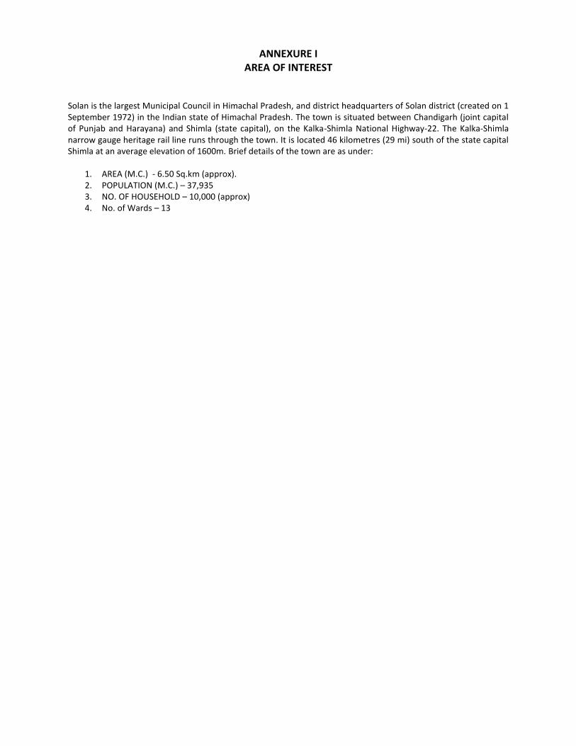
3. Project Area Solan is the largest Municipal Council in Himachal Pradesh, and district headquarters of Solan district (created on 1 September 1972) in the Indian state of Himachal Pradesh. The town is situated between Chandigarh (joint capital of Punjab and Harayana) and Shimla (state capital), on the Kalka-Shimla National Highway-22. The Kalka-Shimla narrow gauge heritage rail line runs through the town. It is located 46 kilometres (29 mi) south of the state capital Shimla at an average elevation of 1600m. Brief details of the town are as under:
1. AREA (M.C.) - 6.50 Sq.km (approx). 2. POPULATION (M.C.) – 37,935 3. NO. OF HOUSEHOLD – 10,000 (approx) 4. No. of Wards – 13
4. Scope of Work The selected bidder is expected to provide technical and management support during the planning, design and
implementation phases of GIS base map preparation activity as described below but not limited to, for satisfactory
performance of the services within the Contractual framework.
4.1 Preparation of GIS Base Map The main objective of the project is to develop a detailed GIS Base map on a scale of 1:1,000 for the Solan town of
the state. The details of features to be interpreted are given in Annexure II. The preliminary interpreted map
should be ground verified and the final map is to be prepared by incorporating the ground truth data. These
detailed maps consisting of the planimetric details, Cadastral boundaries, micro level land use and utility services
need to be generated using the latest technologies like DGPS, image processing and digital data capture using
Quickbird data with 60 cm resolution or better, Pan Sharpened colour imagery supplemented by the ground truth
collection.
4.1.1 Procurement of Satellite Imagery:
Consultant will procure the Quick bird Pan Sharpened colour imagery data sets or better imagery from the concerned agency. MCS will assist by issuing a letter to concerned authorities for quick procurement of satellite imagery with following attributes: i) Resolution : 60 cm or better
ii) Area coverage : present spread of ULB with sufficient buffer
iii) Data Products : Digital and hard copy images
4.1.2 DGPS Survey & Geo Referencing
To correct various geometric anomalies in raw satellite imagery, Ground Control Points (GCP) collected
through Differential Global Positioning System (DGPS) Survey will be used for Geo referencing of the
imagery. Geo Referencing and Geo-coding of data should be on WGS-84 with projection on UTM. For the
DGPS Survey, GCPs should be selected at well-defined sharp points both on the ground and on imagery. A
total of 15 to 20 GCPs should be collected and these should be evenly distributed over the town area. 4.1.3 Digitization and Map Preparation
Proper grid and projection shall be designed for the whole of the town. This is essential for proper
representation of graphical data and location related unique Ids for each property, which shall form part
of GIS for the spatial analysis. In the case of digitization, the data is checked for dimensional accuracy,
completeness, displacement, edge matching, symbology, and layering. All undershoots/overshoots;
dangling vertices shall get removed in the process. The method to be adopted for digitization shall
confirm as per the standards discussed below:
i) Minimum mappable unit on Maps -- 1 mm on scale
ii) Location accuracy in GIS -- 1 mm on scale
iii) Minimum spatial unit in GIS -- 2 mm on scale
iv) Registration Error threshold in GIS -- 0.25 mm on scale
v) Coordinate movement/Weed tolerance -- 0.25 mm on scale
All features like Buildings, Vacant Plots, Roads (National Highways, State Highways, City Roads and
Streets), Bridges (Flyovers, Railway Bridges, etc), Railway Tracks, Parks, Gardens, Stadiums, Slums, Traffic
Squares, Water Bodies (River, Lake, Pond, Drainage, Canal etc), Over Head Tanks, etc should be extracted
from imagery through on screen / Heads on digitization technique. The hard copy of the maps with all the
above digitized features is to be prepared on 1:750 scale for updation of base map through field survey.
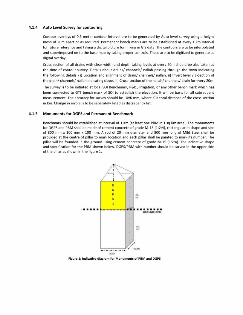
4.1.4 Auto Level Survey for contouring
Contour overlays of 0.5 meter contour interval are to be generated by Auto level survey using a height
mesh of 20m apart or as required. Permanent bench marks are to be established at every 1 km interval
for future reference and taking a digital picture for linking in GIS data. The contours are to be interpolated
and superimposed on to the base map by taking proper controls. These are to be digitized to generate as
digital overlay.
Cross section of all drains with clear width and depth taking levels at every 20m should be also taken at
the time of contour survey. Details about drains/ channels/ nallah passing through the town indicating
the following details:- i) Location and alignment of drain/ channels/ nallah, ii) Invert level / L-Section of
the drain/ channels/ nallah indicating slope, iii) Cross-section of the nallah/ channels/ drain for every 20m
The survey is to be initiated at local SOI Benchmark, R&B., Irrigation, or any other bench mark which has
been connected to GTS bench mark of SOI to establish the elevation. It will be basis for all subsequent
measurement. The accuracy for survey should be 10√K mm, where K is total distance of the cross section
in Km. Change in errors is to be separately listed as discrepancy list.
4.1.5 Monuments for DGPS and Permanent Benchmark
Benchmark should be established at interval of 1 Km (at least one PBM in 1 sq Km area). The monuments for DGPS and PBM shall be made of cement concrete of grade M-15 (1:2:4), rectangular in shape and size of 800 mm x 100 mm x 100 mm. A rod of 20 mm diameter and 800 mm long of Mild Steel shall be provided at the centre of pillar to mark location and each pillar shall be painted to mark its number. The pillar will be founded in the ground using cement concrete of grade M-15 (1:2:4). The indicative shape and specification for the PBM shown below. DGPS/PBM with number should be carved in the upper side of the pillar as shown in the figure 1.
Figure 1: Indicative diagram for Monuments of PBM and DGPS
4.2 Survey and Updation of Base Map The consultant will be responsible for integration of available data with Base Map in GIS relating to slum data,
environmental data, infrastructural data and vendor zoning data sets in addition to the data collection during the
preparation\ updation of base map. The consultant will collect the data in proper field data sheet format, some of
the proposed field data sheet format for the data collection given at annexure II. The base map hard copy
prepared through on screen digitization of imagery as discussed above is to be used for ward wise survey for the
updation purpose and finalization of layer wise Base Map with the attributes, as per Annexure II (a).
4.3 Final Base Map Final base map is to be prepared incorporating the data collected from survey and the data for different entities.
Hard copy base maps are to be prepared at 1: 1000 scale ward wise. The base maps will be prepared in various
layers for ease of operation in GIS. Layer and data structures can be modified depending on the local requirements
of ULB after approval from MCS. The details of the layers for base map are given at Annexure III.
4.4 Property Survey
This task involves Property data verification and collection of relevant information of each Property of Solan town
through contact survey, database generation, and taking digital photograph of each property. The database and
digital photograph should link to GIS Base Map.
The specific activities for this phase are briefly discussed below:
1. Detailed survey of each property/holding through contact survey and its database generation as per
suggested format given in Annexure II.
2. Database structure design for property/holdings to keep all records collected during field survey and as
mandated for property tax calculation as per MCS mandate
3. Integration and verification of existing holding data available with ULBs through contact survey. The
details to be collected through contact survey for property/holdings includes
a. Details of owner name, property/holding address, occupancy status, building age and other
parameters necessary for holding tax calculation
b. Status of other municipal facilities like – water connection, sewerage connection etc.
c. Floor wise (with usage detail/category) carpet area/taxable area, structure,
d. Other information as suggested in the Property Survey Format under Annexure II.
4. Digital photograph of each property within the municipal boundary and its linking with respective
property/holdings database
4.5 Detailed Survey and Verification
The consultant will organize a detailed property survey to collect information on total built up area, area on
ground floor and verification of total taxable area with floor wise structure and usage detail for each property as
per the suggested format and its database generation and integration with Base Map.
During the survey the consultants shall collect and verify the following information for each property as per
property survey format given in Annexure II. Surveyors will record all information about the property like:
Parcel ID and date of survey
Respondent Name and its status
Property Usage like Residential/Non-residential/Mix
Category in case of Non-residential use of property as given in the Field data sheet format
Following details to be collected through contact survey for property/holdings:
Owner Name, Father/Husband Name of Owner, Property Address, Mobile number of property owner
Existing Property Number, Old Holding Number (If any) Revenue circle, Ward No, electric connection
consumer ID etc
Occupancy status: rented /self-occupied/mix
Total area on ground floor and total Built up area in case of individual buildings only
Municipal facilities status like water connection, sewerage connection
Measurement detail – plot area, total built up area and its break up
Floor wise built up area detail with roof type/house type, usage with floor detail etc.
Age of Building
In case of Multi-storey Building (Commercial complex/Apartments) following information shall be
also collected
o Apartment/Building Name
o Total No. of Property
o Lift Facility
o Total built up area
o Total number of floors excluding ground floor
o Total open space area
o Status of different facility like lift, power backup, parking, fire fighting
o Total no. of residential and non-residential holdings
o Source of water for the building
In case of Commercial/Industrial following additional information shall be also collected
o Firm/Shop/Industry Name
o License Status – Yes/No
o Firm/Shop/Industry Owner Name and address
o License status and license no.
o Shop area
o License validity date
o Business/Industry type
4.6 Compilation of Data as per Database Structure
The consultant will compile the data strictly as per agreed database structure. The consultant shall also integrate
existing property number as per municipal record for each property except new properties identified during
survey. Unique ID shall be structured for each property considering standard practices.
4.7 Integration of Database with Base Map and its Updation
The selected consultant shall integrate the final database for each property with the base map database and also
update the thematic layers of base map accordingly.
4.8 Digital Photograph of each Property Linked with Base Map
The selected consultant shall take digital photograph of each property and it should be linked with respective
database of the building in base map.
4.9 Updation of Base Map
During the survey if there is any change in status of admistrative boundaries (like ward boundary, tax zone, circle)
Parcel, Buildings and other utilities including road, drainage, sewerage, water network, street light, OHT etc. it
should be updated in the Base Map.
4.10 Workshop and Training
The consultant shall organize atleast 3 workshops and training during the Project period. The participants of the
workshop will be executives and staff of the ULBs. All the workshops during the project period shall be focused on
work progress, training on survey, mapping, database integration and updation of data.
5. Outputs and Deliverables Under this contract the Consultant’s payments will be output and deliverables based. It is very important to note
clearly and in detail the exact outputs required and what they should contain. The desired outputs & deliverables
under this contract are as shown below. 5.1 Satellite Data
1. Rectified satellite data along with GCP file 2. Soft copies of images in .img and JPEG formats
5.2 DGPS Survey
3. The processed data of the DGPS survey with a photograph of each GCP with monument 4. A neat sketch of each DGPS point showing the location on A4 size drawing
5.3 Topographical survey The following details shall be submitted on completion of the survey
1. All original field books related with utilities, land use and auto level survey 2. All the survey details in AutoCAD format on a CD / DVD and 2 draft prints of the same
5.4 Base Map
1. Ward wise check prints in Hard copy on 1:2500 or large scale containing all the thematic layers, contours and administrative boundaries (In A0 Paper – two sets)
2. Digital base map of all the thematic layers on 1:2500 scale in 3 sets in hard copy (A0 Paper) and one set in
soft copy in GIS format and PDF format 3. Ward wise check prints in Hard copy on 1:750 scale (Two sets on A0 Paper) and PDF format
4. Ward wise Final Base Map (Hard Copy) on 1:1000 scale (Five sets of multi-colour plotted maps on A0
paper) and PDF format
5. Digital data of base map in DXF/DWG, SHP file format along with soft copy of base map to a scale of 1:2500 and 1:5000 (soft copy) for the total town area in DXF/DWG, SHP and PDF format which shall contain foot prints of each building, slum boundary ward wise, roads, nalas, Canals, railway lines, bridges, water bodies duly incorporating cadastral information, Locality, ward, block, slum, and municipal boundaries with contour information at 0.5 Meter interval.
6. Base maps on 1:2500 in hard copy (Five sets of multi-colour plotted maps on A0 Paper) and PDF format
7. Base maps on 1:5000 in hard copy (Five sets of multi-colour plotted maps on A0 Paper) and PDF format
8. Ward wise Slum boundary with dwellings and utilities/basic infrastructure map on 1:500 scale in soft copy
– PDF format
5.5 Reports
1. Town wise Inception Report for the Project that describe the detailed methodology, area of interest,
quality control and work schedule should be submitted within 2 weeks after issue of work order – 3 sets
((for each town) and soft copy in word and PDF
2. Integrated Project Progress Report (to be submitted on 25th day of each calendar month after submission of Inception report) – soft copy (Word file only)
3. Town wise Detailed Project Report at the end of the Project – 10 sets and soft copy (In word and PDF)
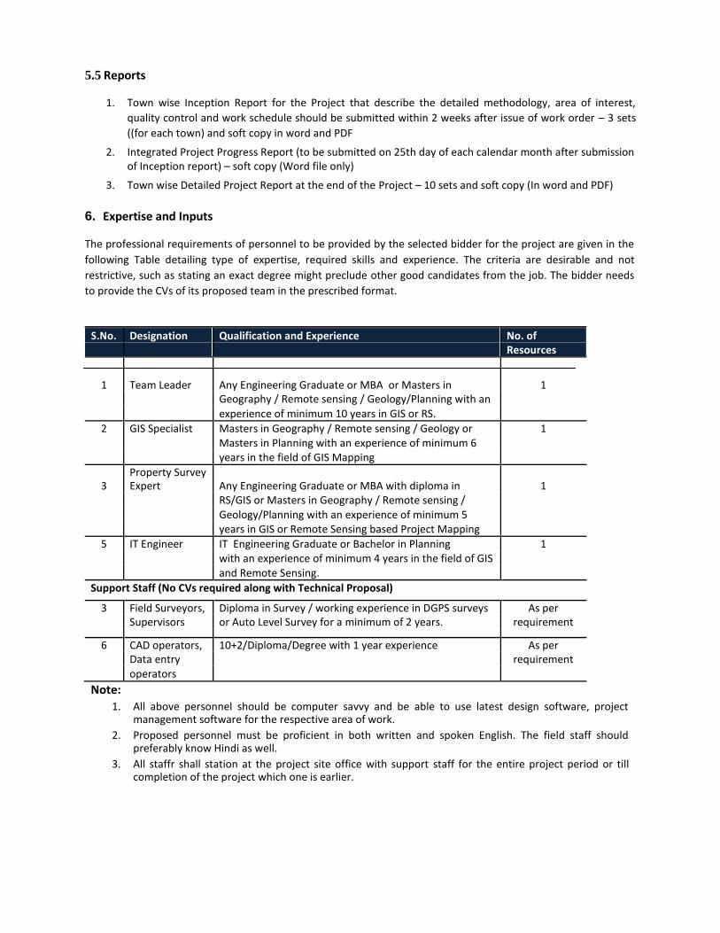
6. Expertise and Inputs The professional requirements of personnel to be provided by the selected bidder for the project are given in the
following Table detailing type of expertise, required skills and experience. The criteria are desirable and not
restrictive, such as stating an exact degree might preclude other good candidates from the job. The bidder needs
to provide the CVs of its proposed team in the prescribed format. Key Professionals
S.No. Designation Qualification and Experience No. of Resources
1 Team Leader Any Engineering Graduate or MBA or Masters in 1 Geography / Remote sensing / Geology/Planning with an
experience of minimum 10 years in GIS or RS.
2 GIS Specialist Masters in Geography / Remote sensing / Geology or 1 Masters in Planning with an experience of minimum 6
years in the field of GIS Mapping
3 Property Survey Expert Any Engineering Graduate or MBA with diploma in 1
RS/GIS or Masters in Geography / Remote sensing / Geology/Planning with an experience of minimum 5
years in GIS or Remote Sensing based Project Mapping
5 IT Engineer IT Engineering Graduate or Bachelor in Planning 1 with an experience of minimum 4 years in the field of GIS and Remote Sensing.
Support Staff (No CVs required along with Technical Proposal)
3 Field Surveyors, Diploma in Survey / working experience in DGPS surveys As per Supervisors or Auto Level Survey for a minimum of 2 years. requirement
6 CAD operators, 10+2/Diploma/Degree with 1 year experience As per Data entry requirement operators
Note: 1. All above personnel should be computer savvy and be able to use latest design software, project
management software for the respective area of work. 2. Proposed personnel must be proficient in both written and spoken English. The field staff should
preferably know Hindi as well. 3. All staffr shall station at the project site office with support staff for the entire project period or till
completion of the project which one is earlier.
7. Terms for provision of the services and reporting
1. The consultant will correspond with and report to concerned authorized person from the MCS team. 2. The consultant will work according to the deadlines provided in the current RFP.
3. The consultant will conduct itself in a professional and ethical manner, and will ensure that none of its
actions have an adverse effect on the project.
4. The consultant will set up site office at Project place with complete infrastructure – Computers, Software, Printer, Furniture etc.
5. The consultant will appoint staff for field activity and data entry at site office who will work in close
concern with the local ULB office.
8. Schedule for Output and Deliverables
The firm is expected to complete the work for the municipal council Solan within 6 months from the stipulated
date of commencement of services notified.
9. Payments to the Consultants
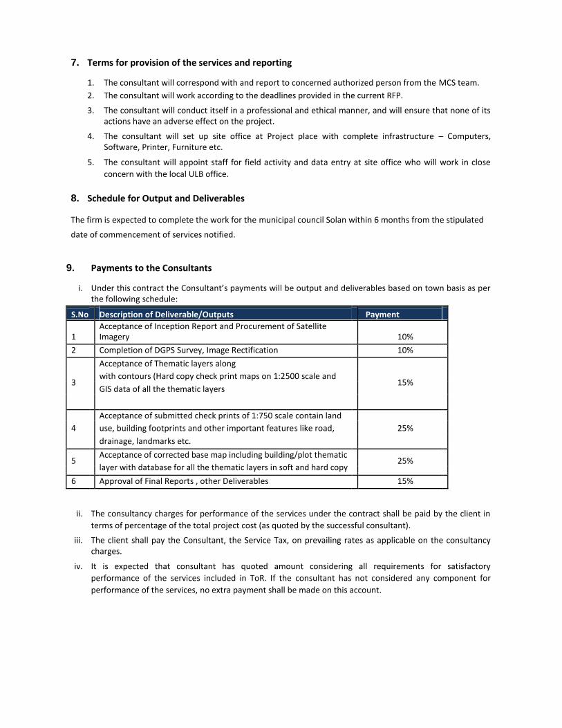
i. Under this contract the Consultant’s payments will be output and deliverables based on town basis as per the following schedule:
S.No Description of Deliverable/Outputs Payment
1
Acceptance of Inception Report and Procurement of Satellite Imagery 10%
2 Completion of DGPS Survey, Image Rectification 10%
Acceptance of Thematic layers along
3 with contours (Hard copy check print maps on 1:2500 scale and
15%
GIS data of all the thematic layers
Acceptance of submitted check prints of 1:750 scale contain land
4 use, building footprints and other important features like road, 25%
drainage, landmarks etc.
5 Acceptance of corrected base map including building/plot thematic
25%
layer with database for all the thematic layers in soft and hard copy
6 Approval of Final Reports , other Deliverables 15%
ii. The consultancy charges for performance of the services under the contract shall be paid by the client in
terms of percentage of the total project cost (as quoted by the successful consultant).
iii. The client shall pay the Consultant, the Service Tax, on prevailing rates as applicable on the consultancy charges.
iv. It is expected that consultant has quoted amount considering all requirements for satisfactory
performance of the services included in ToR. If the consultant has not considered any component for
performance of the services, no extra payment shall be made on this account.

10. QUALITY CONTROL
The consultant shall follow standard Government of India standards and guidelines for Survey, Mapping and
Database generation. Each property shall be measured accurately and the carpet area calculated as per MCS
rules and guidelines.
The thematic layers attribute data should be attached on the basis of unique ID.
The consultant will submit the data on fortnightly basis to the MCS in hard and soft copy. At least 10% of the
data will be taken as sample and checked randomly by the ULB staff and if less than 5% of sample data is found
to be incorrect, the consultant will correct it within 15 days after getting feedback from the ULB and resubmit.
In case of more than 5% of the sample data found to be incorrect, the consultant will have to redo the survey
for the area without any extension of time and resubmit the corrected data for quality check again.

ANNEXUERS
TERMS OF REFERENCE FOR
PREPARATION OF GIS BASE MAP ON 1:1000 SCALE AND PROPERTY SURVEY FOR SOLAN TOWN OF HIMACHAL PRADESH
ANNEXURE I AREA OF INTEREST
Solan is the largest Municipal Council in Himachal Pradesh, and district headquarters of Solan district (created on 1 September 1972) in the Indian state of Himachal Pradesh. The town is situated between Chandigarh (joint capital of Punjab and Harayana) and Shimla (state capital), on the Kalka-Shimla National Highway-22. The Kalka-Shimla narrow gauge heritage rail line runs through the town. It is located 46 kilometres (29 mi) south of the state capital Shimla at an average elevation of 1600m. Brief details of the town are as under:
1. AREA (M.C.) - 6.50 Sq.km (approx). 2. POPULATION (M.C.) – 37,935 3. NO. OF HOUSEHOLD – 10,000 (approx) 4. No. of Wards – 13

ANNEXURE II
FIELD SURVEY FORMATS FOR DATA COLLECTION
(Data collection formats will be finalized with MCS at the time of field survey commencement)
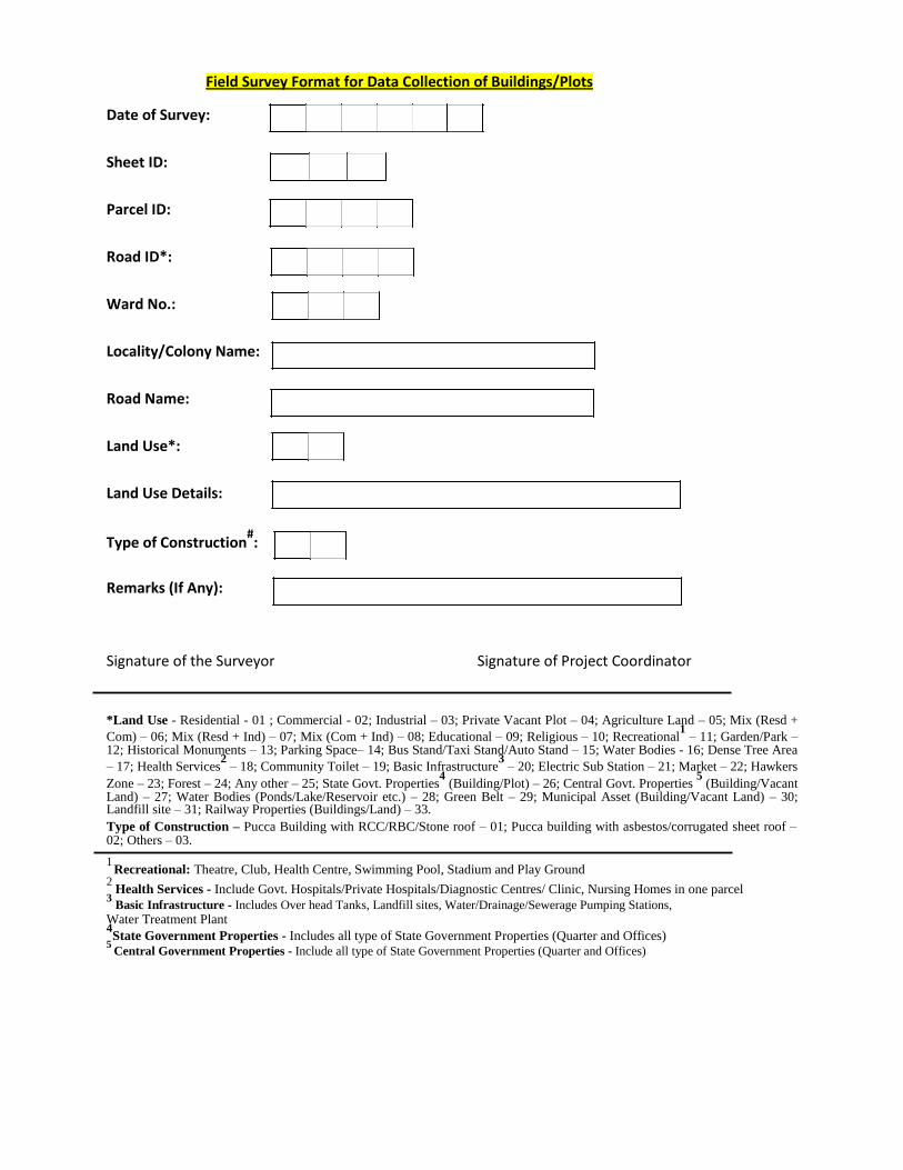
Field Survey Format for Data Collection of Buildings/Plots Date of Survey:
Sheet ID:
Parcel ID:
Road ID*:
Ward No.:
Locality/Colony Name:
Road Name:
Land Use*:
Land Use Details:
Type of Construction#:
Remarks (If Any):
Signature of the Surveyor Signature of Project Coordinator
*Land Use - Residential - 01 ; Commercial - 02; Industrial – 03; Private Vacant Plot – 04; Agriculture Land – 05; Mix (Resd +
Com) – 06; Mix (Resd + Ind) – 07; Mix (Com + Ind) – 08; Educational – 09; Religious – 10; Recreational1 – 11; Garden/Park –
12; Historical Monuments – 13; Parking Space– 14; Bus Stand/Taxi Stand/Auto Stand – 15; Water Bodies - 16; Dense Tree Area
– 17; Health Services2 – 18; Community Toilet – 19; Basic Infrastructure
3 – 20; Electric Sub Station – 21; Market – 22; Hawkers
Zone – 23; Forest – 24; Any other – 25; State Govt. Properties4 (Building/Plot) – 26; Central Govt. Properties
5 (Building/Vacant
Land) – 27; Water Bodies (Ponds/Lake/Reservoir etc.) – 28; Green Belt – 29; Municipal Asset (Building/Vacant Land) – 30; Landfill site – 31; Railway Properties (Buildings/Land) – 33. Type of Construction – Pucca Building with RCC/RBC/Stone roof – 01; Pucca building with asbestos/corrugated sheet roof – 02; Others – 03. 1 Recreational: Theatre, Club, Health Centre, Swimming Pool, Stadium and Play Ground
2 Health Services - Include Govt. Hospitals/Private Hospitals/Diagnostic Centres/ Clinic, Nursing Homes in one parcel
3 Basic Infrastructure - Includes Over head Tanks, Landfill sites, Water/Drainage/Sewerage Pumping Stations,
Water Treatment Plant
4State Government Properties - Includes all type of State Government Properties (Quarter and Offices)
5 Central Government Properties - Include all type of State Government Properties (Quarter and Offices)
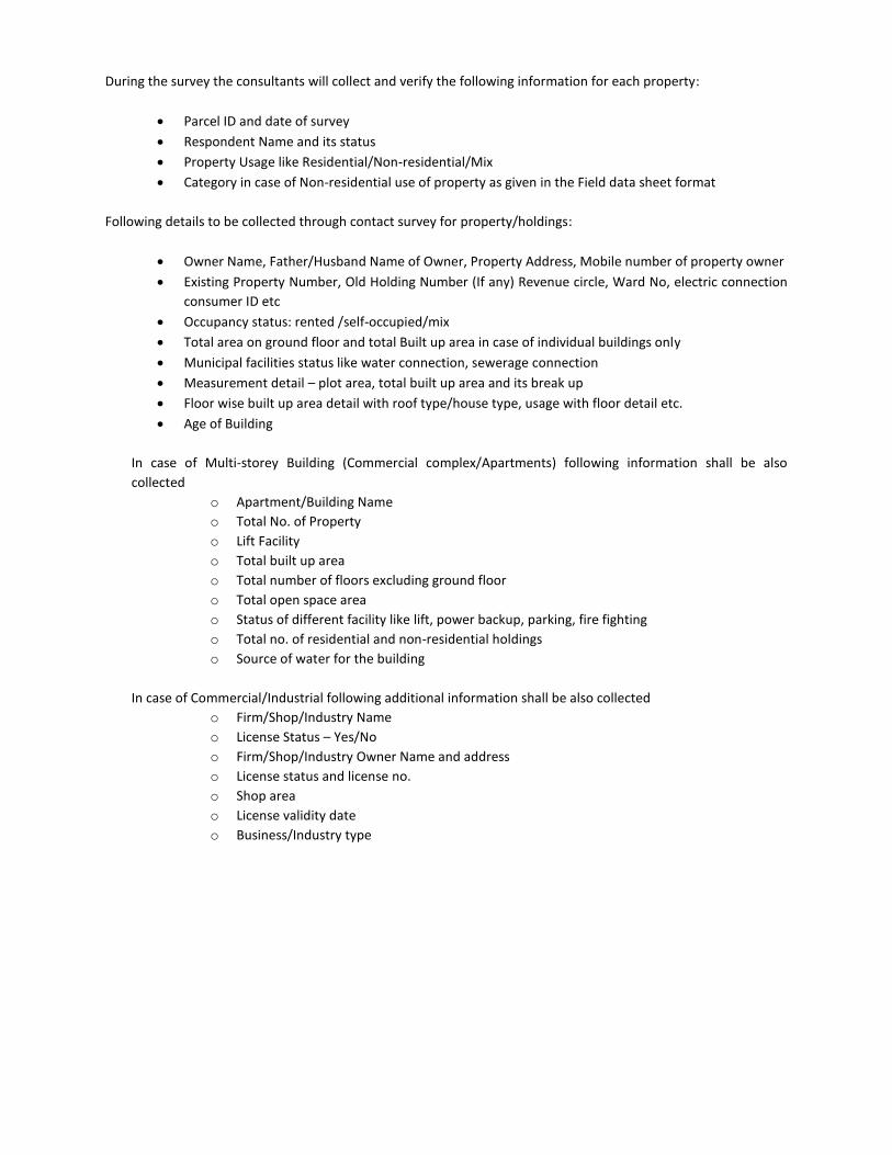
During the survey the consultants will collect and verify the following information for each property:
Parcel ID and date of survey
Respondent Name and its status
Property Usage like Residential/Non-residential/Mix
Category in case of Non-residential use of property as given in the Field data sheet format
Following details to be collected through contact survey for property/holdings:
Owner Name, Father/Husband Name of Owner, Property Address, Mobile number of property owner
Existing Property Number, Old Holding Number (If any) Revenue circle, Ward No, electric connection
consumer ID etc
Occupancy status: rented /self-occupied/mix
Total area on ground floor and total Built up area in case of individual buildings only
Municipal facilities status like water connection, sewerage connection
Measurement detail – plot area, total built up area and its break up
Floor wise built up area detail with roof type/house type, usage with floor detail etc.
Age of Building
In case of Multi-storey Building (Commercial complex/Apartments) following information shall be also
collected
o Apartment/Building Name
o Total No. of Property
o Lift Facility
o Total built up area
o Total number of floors excluding ground floor
o Total open space area
o Status of different facility like lift, power backup, parking, fire fighting
o Total no. of residential and non-residential holdings
o Source of water for the building
In case of Commercial/Industrial following additional information shall be also collected
o Firm/Shop/Industry Name
o License Status – Yes/No
o Firm/Shop/Industry Owner Name and address
o License status and license no.
o Shop area
o License validity date
o Business/Industry type
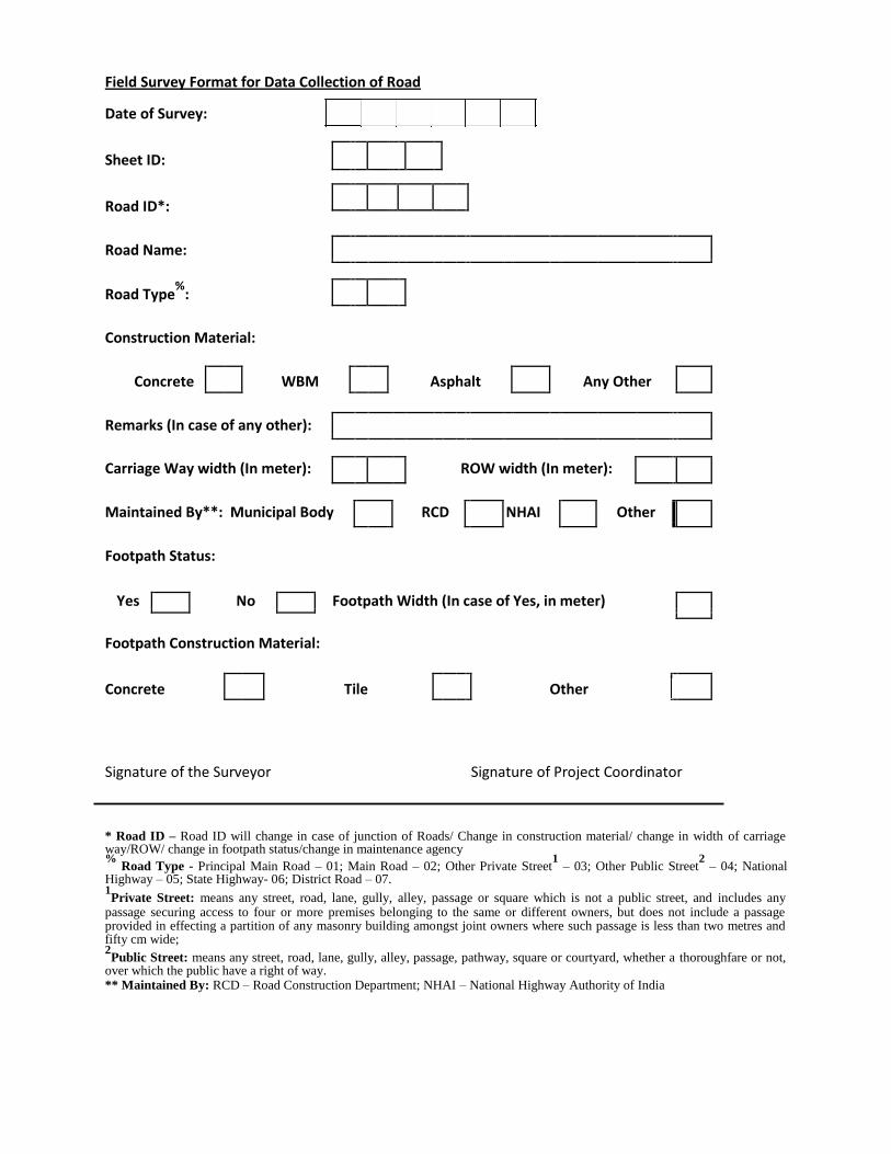
Field Survey Format for Data Collection of Road Date of Survey:
Sheet ID:
Road ID*:
Road Name:
Road Type%
:
Construction Material:
Concrete WBM Asphalt Any Other
Remarks (In case of any other):
Carriage Way width (In meter): ROW width (In meter):
Maintained By**: Municipal Body RCD NHAI Other
Footpath Status:
Yes No Footpath Width (In case of Yes, in meter)
Footpath Construction Material:
Concrete
Tile
Other
Signature of the Surveyor Signature of Project Coordinator * Road ID – Road ID will change in case of junction of Roads/ Change in construction material/ change in width of carriage way/ROW/ change in footpath status/change in maintenance agency %
Road Type - Principal Main Road – 01; Main Road – 02; Other Private Street1 – 03; Other Public Street
2 – 04; National
Highway – 05; State Highway- 06; District Road – 07. 1Private Street: means any street, road, lane, gully, alley, passage or square which is not a public street, and includes any
passage securing access to four or more premises belonging to the same or different owners, but does not include a passage provided in effecting a partition of any masonry building amongst joint owners where such passage is less than two metres and fifty cm wide; 2Public Street: means any street, road, lane, gully, alley, passage, pathway, square or courtyard, whether a thoroughfare or not,
over which the public have a right of way. ** Maintained By: RCD – Road Construction Department; NHAI – National Highway Authority of India
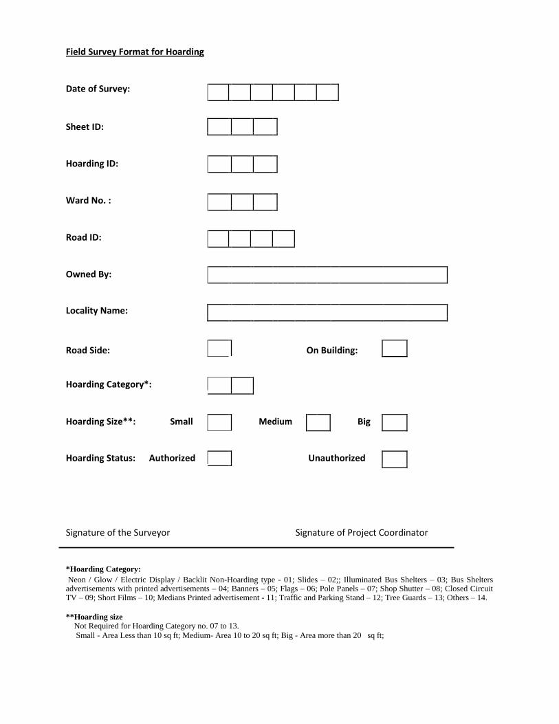
Field Survey Format for Hoarding
Date of Survey:
Sheet ID:
Hoarding ID:
Ward No. :
Road ID:
Owned By:
Locality Name:
Road Side:
On Building:
Hoarding Category*:
Hoarding Size**: Small Medium Big
Hoarding Status: Authorized Unauthorized
Signature of the Surveyor Signature of Project Coordinator
*Hoarding Category: Neon / Glow / Electric Display / Backlit Non-Hoarding type - 01; Slides – 02;; Illuminated Bus Shelters – 03; Bus Shelters
advertisements with printed advertisements – 04; Banners – 05; Flags – 06; Pole Panels – 07; Shop Shutter – 08; Closed Circuit TV – 09; Short Films – 10; Medians Printed advertisement - 11; Traffic and Parking Stand – 12; Tree Guards – 13; Others – 14. **Hoarding size
Not Required for Hoarding Category no. 07 to 13. Small - Area Less than 10 sq ft; Medium- Area 10 to 20 sq ft; Big - Area more than 20 sq ft;
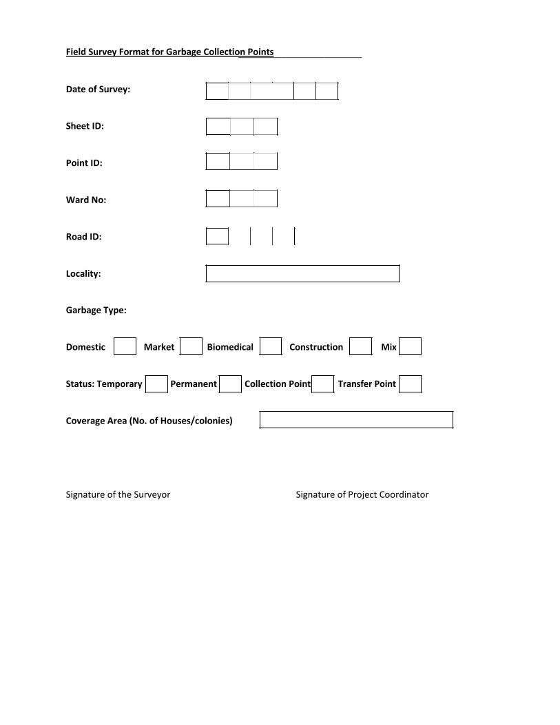
Field Survey Format for Garbage Collection Points
Date of Survey:
Sheet ID:
Point ID:
Ward No:
Road ID:
Locality:
Garbage Type:
Domestic Market Biomedical Construction Mix
Status: Temporary Permanent Collection Point Transfer Point
Coverage Area (No. of Houses/colonies)
Signature of the Surveyor Signature of Project Coordinator
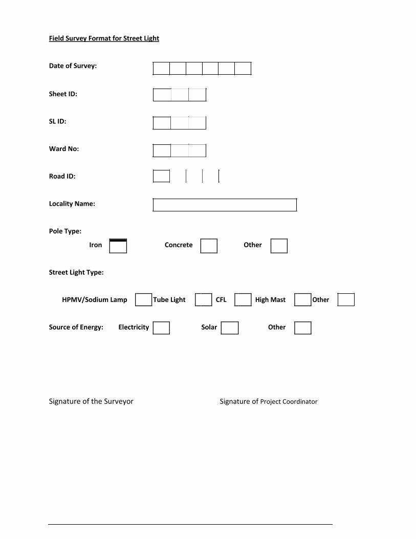
Field Survey Format for Street Light
Date of Survey:
Sheet ID:
SL ID:
Ward No:
Road ID:
Locality Name:
Pole Type:
Iron
Concrete
Other
Street Light Type:
HPMV/Sodium Lamp Tube Light CFL High Mast Other
Source of Energy: Electricity
Solar
Other
Signature of the Surveyor Signature of Project Coordinator
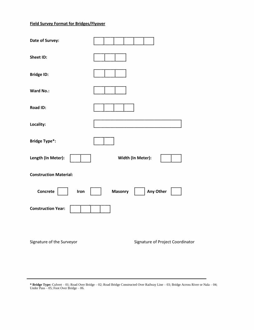
Field Survey Format for Bridges/Flyover
Date of Survey:
Sheet ID:
Bridge ID:
Ward No.:
Road ID:
Locality:
Bridge Type*:
Length (In Meter):
Width (In Meter):
Construction Material:
Concrete Iron Masonry Any Other
Construction Year:
Signature of the Surveyor Signature of Project Coordinator * Bridge Type: Culvert – 01; Road Over Bridge – 02; Road Bridge Constructed Over Railway Line – 03; Bridge Across River or Nala – 04; Under Pass – 05; Foot Over Bridge – 06.
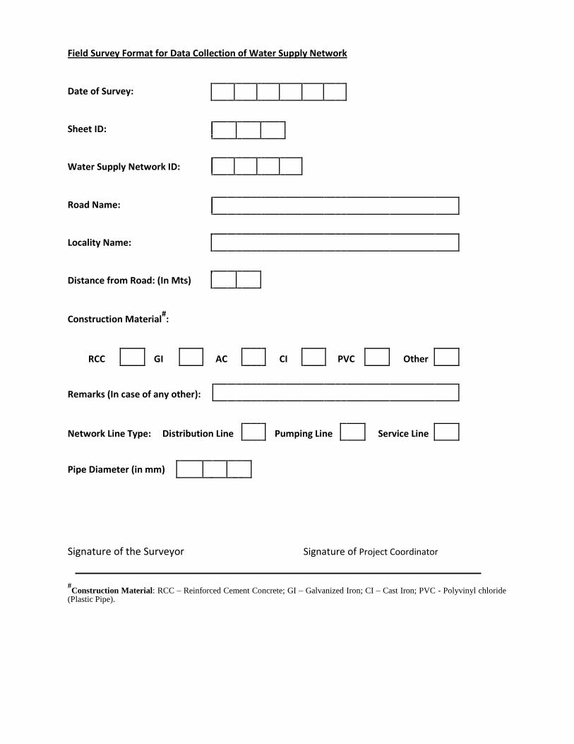
Field Survey Format for Data Collection of Water Supply Network
Date of Survey:
Sheet ID:
Water Supply Network ID:
Road Name:
Locality Name:
Distance from Road: (In Mts)
Construction Material#:
RCC GI AC CI PVC Other
Remarks (In case of any other):
Network Line Type: Distribution Line Pumping Line Service Line
Pipe Diameter (in mm)
Signature of the Surveyor Signature of Project Coordinator
#Construction Material: RCC – Reinforced Cement Concrete; GI – Galvanized Iron; CI – Cast Iron; PVC - Polyvinyl chloride
(Plastic Pipe).
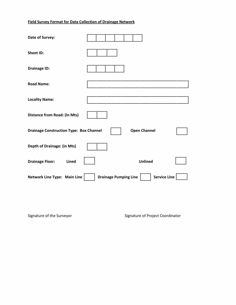
Field Survey Format for Data Collection of Drainage Network
Date of Survey:
Sheet ID:
Drainage ID:
Road Name:
Locality Name:
Distance from Road: (In Mts)
Drainage Construction Type: Box Channel Open Channel
Depth of Drainage: (in Mts)
Drainage Floor: Lined Unlined
Network Line Type: Main Line
Drainage Pumping Line
Service Line
Signature of the Surveyor Signature of Project Coordinator
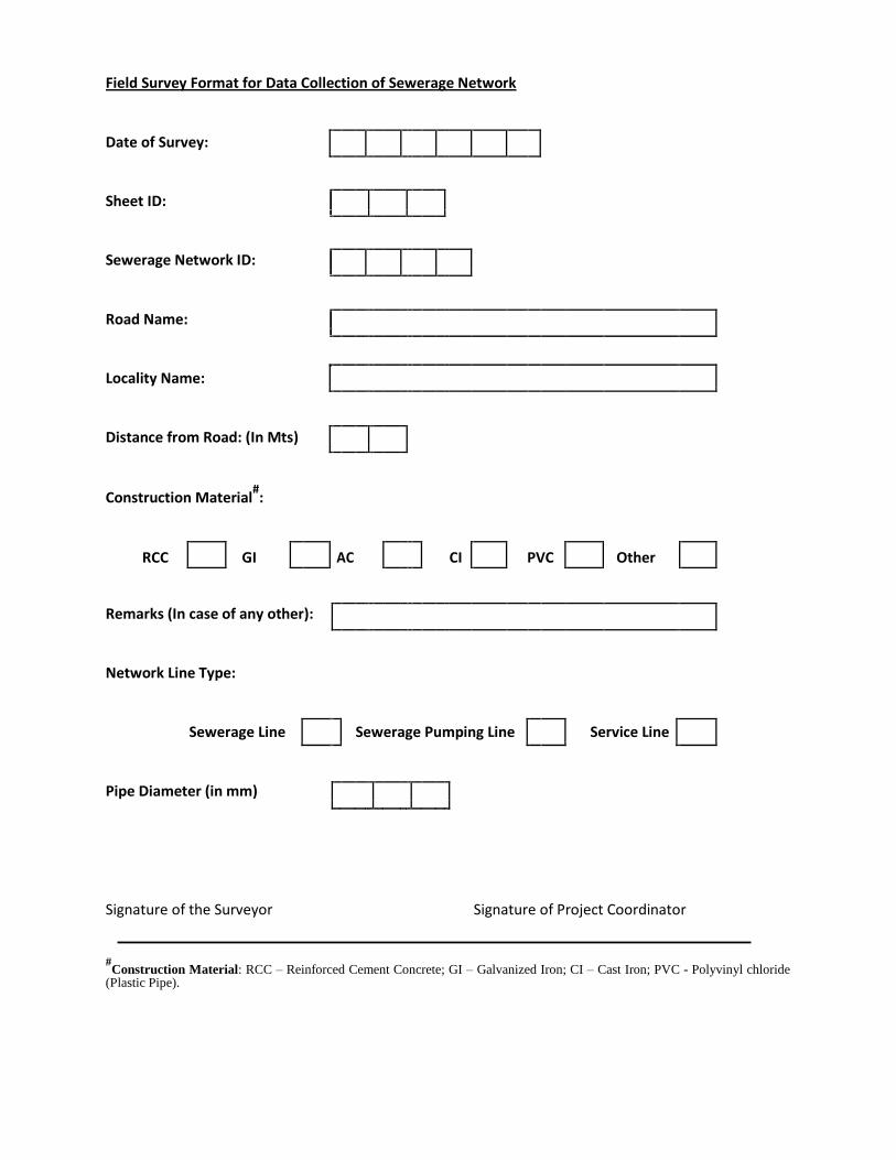
Field Survey Format for Data Collection of Sewerage Network
Date of Survey:
Sheet ID:
Sewerage Network ID:
Road Name:
Locality Name:
Distance from Road: (In Mts)
Construction Material#:
RCC GI AC CI PVC Other
Remarks (In case of any other):
Network Line Type:
Sewerage Line Sewerage Pumping Line Service Line
Pipe Diameter (in mm)
Signature of the Surveyor Signature of Project Coordinator
#Construction Material: RCC – Reinforced Cement Concrete; GI – Galvanized Iron; CI – Cast Iron; PVC - Polyvinyl chloride
(Plastic Pipe).
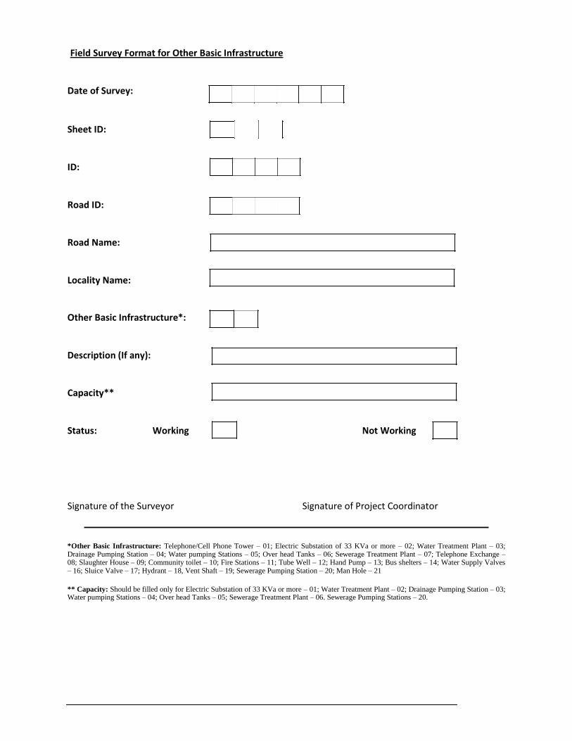
Field Survey Format for Other Basic Infrastructure
Date of Survey:
Sheet ID:
ID:
Road ID:
Road Name:
Locality Name:
Other Basic Infrastructure*:
Description (If any):
Capacity**
Status: Working Not Working
Signature of the Surveyor Signature of Project Coordinator *Other Basic Infrastructure: Telephone/Cell Phone Tower – 01; Electric Substation of 33 KVa or more – 02; Water Treatment Plant – 03; Drainage Pumping Station – 04; Water pumping Stations – 05; Over head Tanks – 06; Sewerage Treatment Plant – 07; Telephone Exchange – 08; Slaughter House – 09; Community toilet – 10; Fire Stations – 11; Tube Well – 12; Hand Pump – 13; Bus shelters – 14; Water Supply Valves – 16; Sluice Valve – 17; Hydrant – 18, Vent Shaft – 19; Sewerage Pumping Station – 20; Man Hole – 21 ** Capacity: Should be filled only for Electric Substation of 33 KVa or more – 01; Water Treatment Plant – 02; Drainage Pumping Station – 03; Water pumping Stations – 04; Over head Tanks – 05; Sewerage Treatment Plant – 06. Sewerage Pumping Stations – 20.
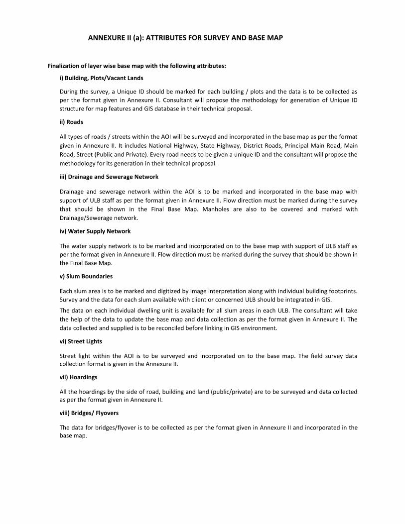
ANNEXURE II (a): ATTRIBUTES FOR SURVEY AND BASE MAP
Finalization of layer wise base map with the following attributes:
i) Building, Plots/Vacant Lands
During the survey, a Unique ID should be marked for each building / plots and the data is to be collected as
per the format given in Annexure II. Consultant will propose the methodology for generation of Unique ID
structure for map features and GIS database in their technical proposal.
ii) Roads
All types of roads / streets within the AOI will be surveyed and incorporated in the base map as per the format
given in Annexure II. It includes National Highway, State Highway, District Roads, Principal Main Road, Main
Road, Street (Public and Private). Every road needs to be given a unique ID and the consultant will propose the
methodology for its generation in their technical proposal.
iii) Drainage and Sewerage Network
Drainage and sewerage network within the AOI is to be marked and incorporated in the base map with
support of ULB staff as per the format given in Annexure II. Flow direction must be marked during the survey
that should be shown in the Final Base Map. Manholes are also to be covered and marked with
Drainage/Sewerage network.
iv) Water Supply Network
The water supply network is to be marked and incorporated on to the base map with support of ULB staff as
per the format given in Annexure II. Flow direction must be marked during the survey that should be shown in
the Final Base Map.
v) Slum Boundaries
Each slum area is to be marked and digitized by image interpretation along with individual building footprints.
Survey and the data for each slum available with client or concerned ULB should be integrated in GIS.
The data on each individual dwelling unit is available for all slum areas in each ULB. The consultant will take
the help of the data to update the base map and data collection as per the format given in Annexure II. The
data collected and supplied is to be reconciled before linking in GIS environment.
vi) Street Lights
Street light within the AOI is to be surveyed and incorporated on to the base map. The field survey data collection format is given in the Annexure II.
vii) Hoardings
All the hoardings by the side of road, building and land (public/private) are to be surveyed and data collected as per the format given in Annexure II.
viii) Bridges/ Flyovers
The data for bridges/flyover is to be collected as per the format given in Annexure II and incorporated in the base map.
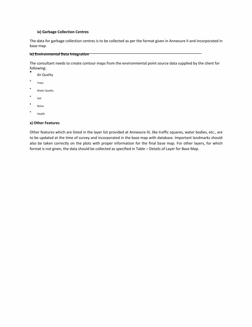
ix) Garbage Collection Centres The data for garbage collection centres is to be collected as per the format given in Annexure II and incorporated in base map. ix) Environmental Data Integration The consultant needs to create contour maps from the environmental point source data supplied by the client for following: Air Quality
Trees
Water Quality
Soil
Noise
Health
x) Other Features Other features which are listed in the layer list provided at Annexure III, like traffic squares, water bodies, etc., are
to be updated at the time of survey and incorporated in the base map with database. Important landmarks should
also be taken correctly on the plots with proper information for the final base map. For other layers, for which
format is not given, the data should be collected as specified in Table – Details of Layer for Base Map.
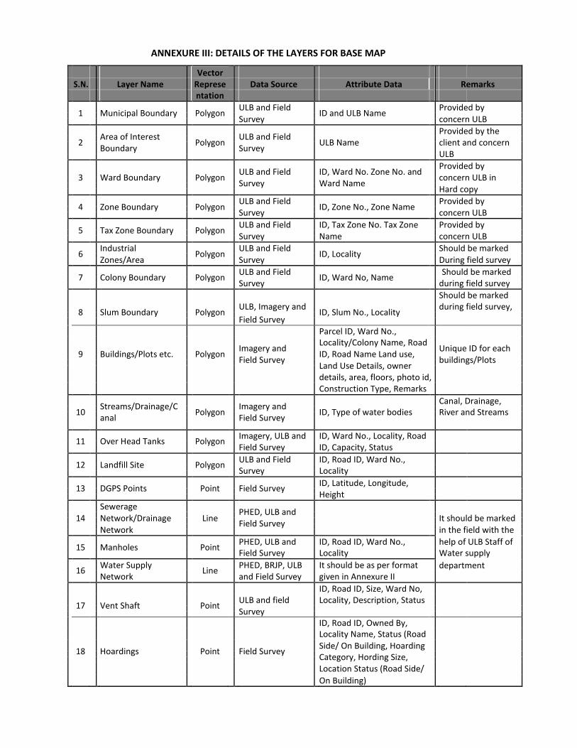
ANNEXURE III: DETAILS OF THE LAYERS FOR BASE MAP Vector
S.N. Layer Name Represe Data Source Attribute Data Remarks
ntation
1
Municipal Boundary
Polygon
ULB and Field ID and ULB Name
Provided by
Survey
concern ULB
Area of Interest
ULB and Field
Provided by the
2
Polygon ULB Name
client and concern
Boundary
Survey
ULB
ULB and Field
ID, Ward No. Zone No. and
Provided by
3
Ward Boundary Polygon
concern ULB in
Survey
Ward Name
Hard copy
4
Zone Boundary
Polygon
ULB and Field ID, Zone No., Zone Name
Provided by
Survey
concern ULB
5
Tax Zone Boundary
Polygon
ULB and Field ID, Tax Zone No. Tax Zone Provided by
Survey
Name concern ULB
6
Industrial Polygon
ULB and Field ID, Locality
Should be marked
Zones/Area
Survey During field survey
7
Colony Boundary
Polygon
ULB and Field ID, Ward No, Name
Should be marked
Survey
during field survey
Should be marked
8
Slum Boundary
Polygon
ULB, Imagery and ID, Slum No., Locality
during field survey,
Field Survey
Parcel ID, Ward No.,
Imagery and
Locality/Colony Name, Road Unique ID for each
9 Buildings/Plots etc. Polygon ID, Road Name Land use,
Field Survey buildings/Plots
Land Use Details, owner details, area, floors, photo id,
Construction Type, Remarks
Streams/Drainage/C
Imagery and
Canal, Drainage,
10 Polygon ID, Type of water bodies River and Streams
anal Field Survey
11
Over Head Tanks
Polygon
Imagery, ULB and ID, Ward No., Locality, Road
Field Survey ID, Capacity, Status
12
Landfill Site
Polygon
ULB and Field ID, Road ID, Ward No.,
Survey Locality
13
DGPS Points
Point
Field Survey
ID, Latitude, Longitude,
Height
Sewerage PHED, ULB and
14
Network/Drainage Line
It should be marked
Field Survey
Network
in the field with the
15
Manholes
Point
PHED, ULB and ID, Road ID, Ward No., help of ULB Staff of
Field Survey Locality Water supply
16
Water Supply Line
PHED, BRJP, ULB It should be as per format department
Network and Field Survey given in Annexure II
ID, Road ID, Size, Ward No,
17
Vent Shaft
Point
ULB and field Locality, Description, Status
Survey
ID, Road ID, Owned By,
Locality Name, Status (Road
18
Hoardings
Point
Field Survey
Side/ On Building, Hoarding
Category, Hording Size,
Location Status (Road Side/
On Building)
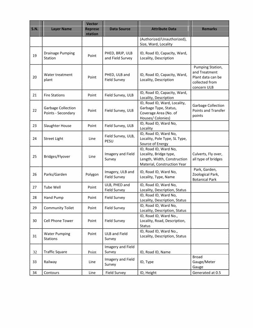
Vector
S.N. Layer Name Represe Data Source Attribute Data Remarks
ntation
(Authorized/Unauthorized),
Size, Ward, Locality
19 Drainage Pumping
Point PHED, BRJP, ULB ID, Road ID, Capacity, Ward,
Station and Field Survey Locality, Description
Pumping Station,
Water treatment
PHED, ULB and
ID, Road ID, Capacity, Ward,
and Treatment
20 Point Plant data can be
plant Field Survey Locality, Description
collected from
concern ULB
21
Fire Stations
Point
Field Survey, ULB ID, Road ID, Capacity, Ward,
Locality, Description
ID, Road ID, Ward, Locality, Garbage Collection
Garbage Collection Garbage Type, Status,
22 Point Field Survey, ULB Points and Transfer
Points - Secondary Coverage Area (No. of
points
Houses/ Colonies)
23
Slaughter House
Point
Field Survey, ULB ID, Road ID, Ward No,
Locality
Field Survey, ULB,
ID, Road ID, Ward No,
24 Street Light Line Locality, Pole Type, SL Type,
PESU
Source of Energy
ID, Road ID, Ward No,
25
Bridges/Flyover
Line Imagery and Field Locality, Bridge type, Culverts, Fly over,
Survey Length, Width, Construction all type of bridges
Material, Construction Year
Imagery, ULB and
ID, Road ID, Ward No,
Park, Garden,
26 Parks/Garden Polygon Zoological Park,
Field Survey Locality, Type, Name
Botanical Park
27
Tube Well
Point ULB, PHED and ID, Road ID, Ward No,
Field Survey
Locality, Description, Status
28
Hand Pump
Point
Field Survey ID, Road ID, Ward No,
Locality, Description, Status
29
Community Toilet
Point
Field Survey ID, Road ID, Ward No,
Locality, Description, Status
ID, Road ID, Ward No.,
30 Cell Phone Tower Point Field Survey Locality, Road, Description,
Status
Water Pumping
Point
ULB and Field
ID, Road ID, Ward No.,
31 Locality, Description, Status
Stations Survey
32 Traffic Square Point
Imagery and Field Survey ID, Road ID, Name
Imagery and Field
Broad
33 Railway Line ID, Type Gauge/Meter
Survey
Gauge
34 Contours Line Field Survey ID, Height Generated at 0.5

S.N. Layer Name Represe Data Source Attribute Data Remarks
ntation
mts interval
35 Power Supply
Line
Field Survey
ID, Type (11KVa/ 33KVa)
Network
ID, Road_ID
36 Electric
Point
Survey
Transformers
Major Hospitals,
Govt. Buildings,
Historical
Monuments, Post
Office, Police
Stations, Major
Imagery and Field
ID, Road ID, Ward, Locality, Industries, and
37 Landmarks
Point Type, Name, Description,
commercial places,
Survey
Status
Electric Substations
of 33 KVa or more,
Telephone
Exchange, etc. At
least one Landmark
should be marked
at every 500 mts.
Road ID, Type, Road Median
(Yes/No); Construction
Imagery and Field
Material, Name, Carriage
38 Road Network Line Way width, ROW width,
Survey
Maintained By Footpath
Status, Footpath Width,
Footpath material,
Double
Imagery and
39 Carriage Way Limited Field ID, Road ID, Width
Line
Survey
Double
Imagery and
40 Right of Way Limited Field ID, Road ID, Width
Line
Survey
Imagery and Field
ID, Type, Road ID,
41 Footpath Line Construction Material,
Survey
Width
Sewerage Treatment PHED, ULB
ID, Road ID, Type (STP/SPS)
42 Plant and Sewerage Point
and Field Survey Capacity, Ward, Locality
Pumping Station
43 Cell Phone Tower/
Point ULB and Field ID, Ward No., Locality, Road
Telephone Tower Survey ID, Parcel ID, Description
44
Bus Shelters
Point ULB and Field ID, Ward No., Locality, Road
Survey ID, Description
Cadastral Map/Town
From ULB and
45 Polygon Land Records ID, Khasra No.
Survey Maps
Department