nl xl - scriptum · nl xl karel tomeï nlxl_mih ... als luxe relatiegeschenk hun weg naar tal van...
TRANSCRIPT

L

NLLX
Karel Tomeï
NLXL_MiH_HR_PRODUCTIE.indd 1 16-08-17 17:30

2
NLXL_MiH_HR_PRODUCTIE.indd 2 16-08-17 17:30
2 3
MADE
IN
HOLLAND
NLLX
Karel Tomeï
NLXL_MiH_HR_PRODUCTIE.indd 3 16-08-17 17:30

4
Voorwoord
Forword
Stille neerslag
Silent Reflection
NLXL_MiH_HR_PRODUCTIE.indd 4 16-08-17 17:30
4 5
The wish to fly might be one of the human race’s oldest desires. Undoubtedly this ancient desire has to do with our fascination with what the world looks like from above – when we are free, and detached from the Earth. This fascination is universal, but coincidence would have it that the Low Lands – of all countries – have a long-standing tradition of so-called bird’s eye views in which the world is captured from the skies – and shown with often stunning precision.
De wens om te kunnen vliegen is misschien wel een van de oudste verlangens van de
mens. En ongetwijfeld heeft deze oerwens te maken met onze fascinatie om de wereld
van bovenaf te kunnen zien. Vrij en los van de aarde. Deze wens is universeel
maar uitgerekend de Lage Landen kennen een lange traditie van zogenaamde
vogelvluchtperspectieven waarin de wereld van bovenaf gezien, op vaak verbluffend wijze,
nauwgezet is weergegeven.
Voorwoord
Forword
Stille neerslag
Silent Reflection
NLXL_MiH_HR_PRODUCTIE.indd 5 16-08-17 17:30
6voorwoord forword
Maybe this is because the Netherlands is not exactly a country of views from high up above. Which makes the often beautifully-manicured and highly-detailed bird’s eye perspectives, which were created in the country’s early history, all the more remarkable. Perhaps they were meant to compensate for the lack of high viewpoints. For instance, in 1544, a cartographically-precise View of Amsterdam from the Skies was published. We see the nascent city of trade from above, allowing us to immediately recognize the Dam, the Damrak, the IJ, the churches, the city’s prominent buildings and practically each individual structure. It is as if the artist, Cornelis Anthonisz (Amsterdam ca. 1505–1553), was hanging above the city in a balloon in order to create this aerial view of the city. One hundred years later, artist Jan Micker (Amsterdam 1598–1664) painted another striking view of Amsterdam. Once again, from a viewpoint that was extraordinary for those days – and this time with exceptionally realistic cloud shadows, making everything look even more real. Long before the invention of photography – or that man was able to look down upon the Earth from a balloon or an airplane – Jan Micker created an unequalled tribute to the city that amazes us even to this day.
This fascination for the home city was not limited to Amsterdam. In the young Dutch Republic, an interest in maps, prints and paintings of cities spread across the country. Whereas elsewhere in Europe, artists were limited by religious and royal commissions – and landscapes invariably formed the background to a religious tableau, a heroic conquest or simply had no significant meaning – to Dutch painters and engravers, these landscapes were the subject of their works of art. This love for the city and the country would quickly culminate in the works of Jacob van Ruijsdael (Haarlem 1628/9–Amsterdam 1682), Meindert Hobbema (Amsterdam 1638–1709) and Gerrit Berckheyde (Haarlem 1638– 1698). At the same time, print series and albums appeared, such as Joan Blaeu’s View of the Cities of the United Netherlands and their Description (Amsterdam 1652) or the 7-kilo Theatrum ichnographicum omnium urbium et præcipuorum oppidorum Belgicarum XVII Provinciarum peraccurate delineatarum or Perfect Depictions of the Maps of the Cities of the XVII Dutch Provinces (Amsterdam 1698) by Frederick de Wit (Gouda 1630–Amsterdam 1706). These atlases were popular in the 17th century among the rich citizens and the nobility, and – as luxury gifts – found their way into the collections of the European Royal Families.
This Dutch fascination with their own landscape goes hand-in-hand with a deeper desire to shape and structure the world to suit their own notions. The hang for predictability, and Holland’s own Holy Trinity – peace, cleanliness and order – are reflected in the parceling of the land and the design of the quickly expanding cities. This strict division of land could even be considered reminiscent of the ubiquitous black-and-white tile floors that were so typical of Dutch homes. The rigid application of the pattern of the tile floors, a sort of mathematical grid, tells us a lot about the order the Dutch imposed on the world through their vision – in fact, it literally shows us how they viewed the world. The parceling of the land in the Dutch polders is really nothing other than a larger rendition of the Dutch tile floors. And those who fly through Dutch airspace, will see – in the straight dikes, polders and parceled meadows – a reference to the painted interiors we know from the hands of 17th-century masters such as Johannes Vermeer (Delft 1632–1675) or Pieter de Hoogh (Rotterdam 1629–Amsterdam 1684). Seen from above, it is instantly clear that the mathematical layout of the Noordoostpolder (1942) is a direct reflection of the Beemster (1612).
The esthetics of the landscape and this fascination with seeing the world from above was not only explored by painters, but also by the very first photographers. The first aerial photos were made from a balloon in 1858, by Félix Nadar (Paris 1820–1910). Shortly thereafter, he made aerial photographs of Paris, on which you could spot the Arc de Triomphe and the boulevards.Dutch aerial photography is of a later date and was primarily developed for cartographic purposes and upon commission by the government. On June 21, 1921, KLM Phototechnical Services was founded. During the first years, aerial photographs were taken by so-called ‘overboard photographers’ who took their pictures at a height of 300 meters, hurtling along at a speed of 100 kilometers an hour. For decades, KLM had sole rights to making aerial shots for urban
Misschien valt dit te verklaren door het volledig ontbreken van hoge uitzichten in onze streken. Des te opvallender zijn juist daarom de vaak prachtig verzorgde en uiterst gedetailleerde vogelvluchtperspectieven
die al vroeg in de Nederlanden ontstonden. Wellicht boden zij een vorm van compensatie voor het ontbreken van hoge standpunten.
Zo verschijnt al in 1544 een cartografisch exact uitgevoerd Gezicht op Amsterdam in vogelvlucht. We zien de ontluikende handelsstad
van boven, waarop we onmiddellijk de Dam, het Damrak, het IJ, de kerken, de voornaamste gebouwen ja zelfs vrijwel ieder ander
bouwwerk afzonderlijk herkennen. Het lijkt of de kunstenaar, Cornelis Anthonisz (Amsterdam ca. 1505–1553), vanuit een luchtballon boven de stad hangt om vanuit daar dit stadsgezicht te maken. En honderd
jaar later schildert de kunstenaar Jan Micker (Amsterdam 1598–1664) een even verbluffend gezicht op Amsterdam. Opnieuw vanuit een voor
die tijd ongekend standpunt met deze keer zelfs uiterst realistische wolkenschaduwen, waardoor het in alles nog echter lijkt. Lang
voordat de fotografie wordt uitgevonden en de mens in staat is om vanuit een ballon of vliegtuig op de aarde neer te kijken schept deze
Jan Micker een weergaloze ode aan de stad die ons tot op de dag van vandaag doet verbazen.
De grote belangstelling voor de eigen stad was overigens niet voorbehouden aan Amsterdam. In de jonge Republiek ontstond
gedurende de zeventiende eeuw overal een grote belangstelling voor plattegronden, prenten en schilderijen van steden. Waren elders
in Europa kunstenaars altijd gebonden aan kerkelijke of vorstelijke opdrachtgevers en vormden landschappen altijd het decor voor een
Bijbels tafereel, een heroïsche overwinning of een nietszeggende achtergrond, de Hollandse schilders en graveurs maakten het landschap zelf tot onderwerp. Deze liefde voor stad en land zou al snel culmineren
in het werk van Jacob van Ruijsdael (Haarlem 1628/9–Amsterdam 1682), Meindert Hobbema (Amsterdam 1638–1709) en Gerrit Berckheyde
(Haarlem 1638–1698). Tegelijkertijd met deze grote schilders verschenen prentseries en albums als Joan Blaeu’s Toonneel der steden van de
Vereenighde Nederlanden met hare beschrijvingen (Amsterdam 1652) of het zeven kilo wegende Theatrum ichnographicum omnium urbium et præcipuorum oppidorum Belgicarum XVII Provinciarum peraccurate
delineatarum oftewel Perfecte aftekeningen der steden van de XVII Nederlandsche Provincien in platte gronden (Amsterdam, 1698) door
Frederick de Wit (Gouda 1630–Amsterdam 1706). Deze atlassen zijn in de zeventiende eeuw populair onder rijke burgers en edelen en vinden als luxe relatiegeschenk hun weg naar tal van Europese vorstenhuizen.
De Hollandse fascinatie voor het eigen landschap gaat hand in hand met een dieper verlangen om de wereld naar eigen goeddunken vorm
te geven en in te richten. De drang naar orde, Hollands eigen heilige drie-eenheid – rust, reinheid en regelmaat – zien we terug in de
verkaveling van het land en de aanleg van de snel expanderende steden. Deze strikte indeling van het land zou zelfs een afgeleide zijn van de
alom aanwezige zwart-witte tegelvloeren die zo bepalend waren voor het Hollandse binnenhuis. De rigide wijze waarop het patroon van de
tegelvloer is toegepast, als mathematisch grid, zegt veel over de orde die de Nederlanders in hun visie oplegden aan de wereld, sterker nog, zoals zij letterlijk de wereld zagen. Het verkavelingspatroon van onze polders
is in wezen niets anders dan een extreme vergroting van de zwart-witte tegelvloer. En wie tegenwoordig het Nederlandse luchtruim invliegt, ziet
in de rechtgetrokken dijken, polders en verkavelde weiden een verwijzing naar de geschilderde interieurs zoals we die kennen van zeventiende-
eeuwse meesters als Johannes Vermeer (Delft 1632–1675) of Pieter de Hoogh (Rotterdam 1629–Amsterdam 1684). Van bovenaf gezien
wordt in een oogopslag duidelijk dat de mathematische indeling van de Noordoostpolder (1942) rechtstreeks terugvoert op de Beemster (1612).
De esthetiek van het landschap en de fascinatie om de wereld van bovenaf te beschouwen is niet alleen door schilders, maar al vanaf het
vroegste ontstaan door fotografen onderzocht. De eerste luchtfoto’s werden al in 1858 vanuit een luchtballon gemaakt, door Félix Nadar (Parijs 1820–1910). Kort daarop maakte hij luchtopnames van Parijs
waarop de Arc de Triomphe en de boulevards te zien waren. De luchtfotografie in ons land is van latere datum en werd vooral
NLXL_MiH_HR_PRODUCTIE.indd 6 16-08-17 17:30
6 7voorwoord forword
construction or expansion purposes. Since 1932, topographical maps have systematically been made with the help of aerial photographs. And since that date, there is an aerial photograph of every little bit of the Netherlands. These photographs were at first taken every ten years and now, as of 1981, they are taken every four years, creating an image database of more than 375,000 photographs.In our day and age, thanks to the development of satellite photos, drones and Google Earth, aerial photography appears to have become quite commonplace. Furthermore, as of June 1, 2013, the Aerial Photography Decree has ceased to apply. As of that date, licenses are no longer needed to take photographs of the Netherlands from the skies.Precisely now that we are becoming used to the view from above – which we can evoke on our screens with the click of our mouse – and that we are photographing our immediate surroundings on a daily basis, a meticulously accumulated series of photographs such as those by Karel Tomeï is so valuable. It is a continuation of a centuries-old tradition, that can be led back to the 17th-century prints of Dutch cities while it also meets our desire to enjoy the beauty of the landscapes around us that are recorded by photographers time and again. This book unites these systematic and esthetic approaches. Tomeï took his first pictures at age five and specialized in aerial photography in 1973. His shots are a silent reflection of endless flights over our land, influenced by the elements, wind gusts, changing cloudscapes and reflections on the ground. Tomeï shows us the Netherlands as we know it, but have never actually seen it. Wim Pijbes
ontwikkeld voor cartografische doeleinden en opdrachten door de overheid. Op 21 juni 1921 wordt de KLM-Fototechnische Dienst opgericht. De luchtfotografie uit die beginjaren geschiedde door
zogenaamde ‘overboordfotografen’ die vanaf een hoogte van driehonderd meter en met een snelheid van honderd kilometer per uur hun opnames maakten. Zo kreeg de KLM decennialang het alleenrecht
tot het veelvuldig maken van luchtopnames in het belang van stedenaanleg of uitbreidingsplannen. Sinds 1932 worden topografische kaarten systematisch gemaakt met behulp van luchtfoto’s. Sindsdien is
van elk stukje Nederland een luchtfoto beschikbaar. Deze luchtfoto’s zijn om de tien jaar opgenomen en vanaf 1981 wordt Nederland zelfs om de
vier jaar gefotografeerd wat inmiddels geleid heeft tot een beeldbank met ruim 375.000 opnames.
In onze tijd lijkt, mede door ontwikkelingen als satellietfoto’s, drones en Google earth, de luchtfotografie haast een alledaags verschijnsel.
Bovendien is per 1 juni 2013 het Besluit Luchtfotografie vervallen. Voor fotografie vanuit de lucht is vanaf die datum boven heel Nederland geen
vergunning meer nodig. Juist nu we zo gewend raken aan de blik van boven, zoals we dat met
een muisklik op ons beeldscherm eenvoudig kunnen realiseren en juist nu we zo vertrouwd zijn met het zelf dagelijks fotograferen van onze
directe omgeving, is een zorgvuldig samengestelde serie beelden als van Karel Tomeï zo waardevol. Het sluit aan op een eeuwenoude traditie, die terugvoert op de zeventiende-eeuwse prentseries van Hollandse steden
en het appelleert tegelijkertijd aan het verlangen naar landschappelijk schoon zoals dat door tal van fotografen telkens opnieuw wordt
vastgelegd. In dit boek komen deze systematische en esthetische benadering samen. Tomeï maakte
zijn eerste foto’s al op vijfjarige leeftijd en specialiseerde zich in 1973 als luchtfotograaf. Zijn fotografische beelden vormen de stille neerslag van eindeloze vluchten boven ons land, afhankelijk van de elementen,
windvlagen, wisselende wolkenluchten en reflecties op de grond. Tomeï laat ons Nederland zien zoals we het kennen, maar nooit eerder
hebben gezien.
Wim Pijbes
NLXL_MiH_HR_PRODUCTIE.indd 7 16-08-17 17:30

NLXL_MiH_HR_PRODUCTIE.indd 8 16-08-17 17:30
10
34
66
100
130
156
192
222
252
284
312
338
360
MADE
IN
HOLLAND
Maakbaar Makeable
Architectuur Architecture
DELTA DELTA
Economie Economy
Innovatie Innovation
Natuur Nature
Historie History
Ontspanning Outdoor recreation
Landschap Landscape
Landgebruik Land Use
Authenticiteit Authenticity
Noordzee North Sea
Double Dutch Double Dutch
NLXL_MiH_HR_PRODUCTIE.indd 9 16-08-17 17:30
10
MNLXL_MiH_HR_PRODUCTIE.indd 10 16-08-17 17:30
10 11
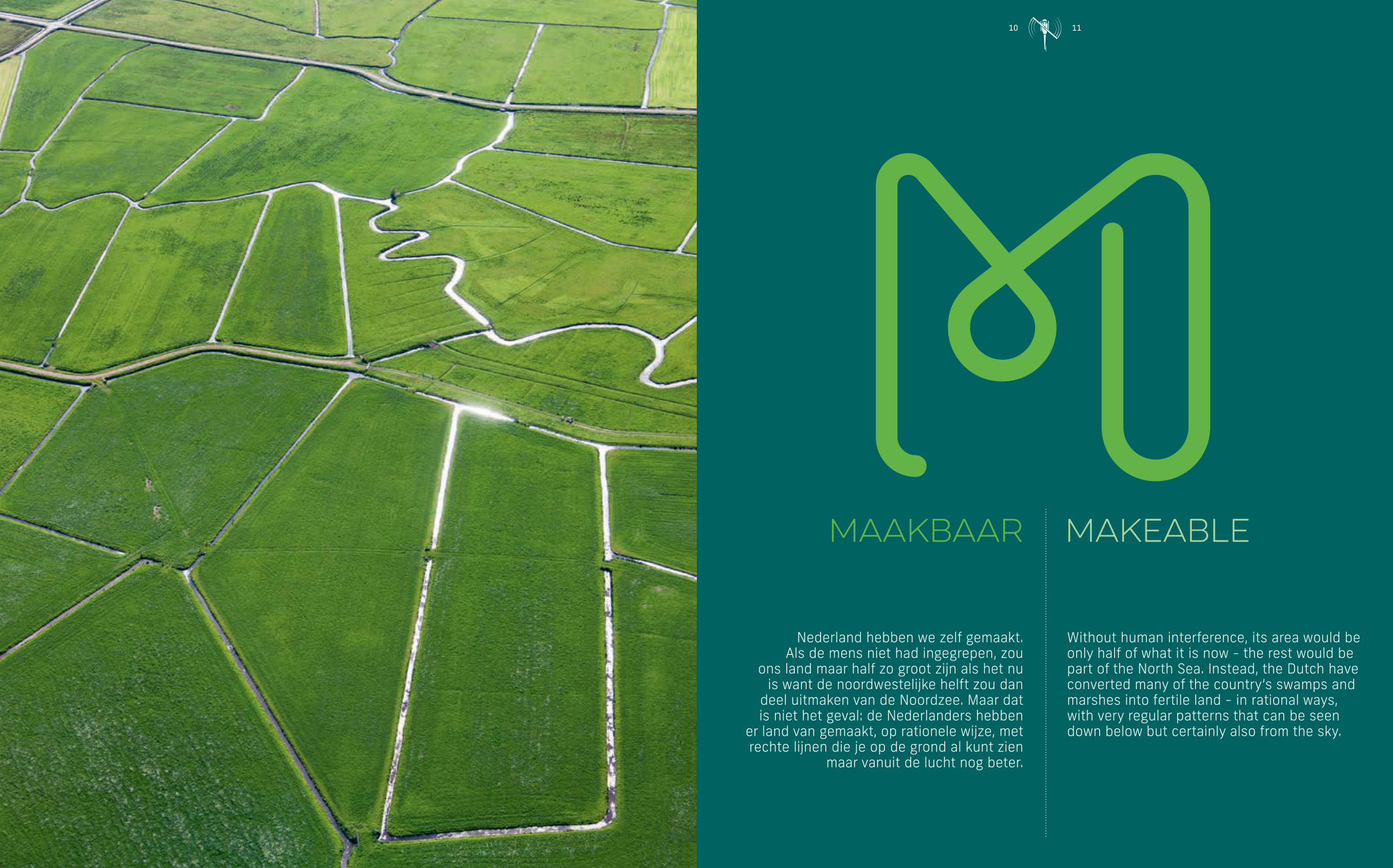
Without human interference, its area would be only half of what it is now - the rest would be part of the North Sea. Instead, the Dutch have converted many of the country’s swamps and marshes into fertile land - in rational ways, with very regular patterns that can be seen down below but certainly also from the sky.
Nederland hebben we zelf gemaakt. Als de mens niet had ingegrepen, zou
ons land maar half zo groot zijn als het nu is want de noordwestelijke helft zou dan
deel uitmaken van de Noordzee. Maar dat is niet het geval: de Nederlanders hebben
er land van gemaakt, op rationele wijze, met rechte lijnen die je op de grond al kunt zien
maar vanuit de lucht nog beter.
MMaakbaar Makeable
NLXL_MiH_HR_PRODUCTIE.indd 11 16-08-17 17:30

12MMaakbaar Makeable
The Dutch believe that everything is makeable, and that everything can be done, changed, adjusted, and remade from scratch, if need be.
The northwestern half of the country is a patchwork of straight lines: ditches and canals, roads and railroads, housing blocks. Only the rivers and the sea produce irregular patterns, rounder shapes, arches, meandering lines. Yet even there, on closer inspection, human interference is visible: straight dams and piers to tame the sea, and regular breakwaters to control the rivers.
The other half of the country, the drier area higher up, has also been modified over time: land consolidation has resulted in efficiently rectangular fields, and streams have been straightened to prevent flooding. Tons of fertile soil have been moved to increase agricultural production in barren places, fertilizer has been added, and land use has been regulated and controlled. With less water around, there is less irregularity, but luckily the remaining forests and moors - much appreciated manifestations of nature in a country densely populated by hard-working people who also need recreational space - make up for this.
The Dutch believe in the ‘makeability’ of things; also of society, of life itself. If thought out properly and prepared after a careful weighing of the pros and cons and risks beforehand, anything can be achieved. The Dutch themselves are not surprised that their country often features at the top of the list in all kinds of global statistics - such as quality of health care and education, freedom of press and opinion, work fulfilment, satisfaction with life as it is, happiness even.
Inevitably there are also downsides to all this order. The Dutch complain about too many rules, too much regularity, too little excitement among all these straight lines and fixed time schedules. A growing population, used to high living standards, demands commensurate housing, which is provided thanks to the cooperation of the authorities and commercial parties. People are pleased they can move to comfortable and affordable housing surrounded by an excellent infrastructure, but the new additions to existing cities are also perceived to be overregulated and somewhat boring. The uniformity of the houses (mostly rented), standardized gardens of 6 by 8 meters, preordained roads for cars, bicycles and pedestrians, and a windy new park here and there, do not invite much more activity than washing your car and tending your garden.
Dutch regularity can be seen even more clearly from the sky. From above, the Netherlands is a land of blocks and boxes, of rectangular fields separated by straight canals. Only nature itself imposes irregularity: bays and inlets, meandering streams and rivers, and differences in height, soil quality or ground water levels - however subtle. Not by coincidence, the highly colorful squares of Mondrian’s cubist paintings of the early 20th century strongly resemble the Dutch tulip fields in spring.
The same order of things can be seen in Dutch society. Most people prefer order, security, a pleasant degree of predictability. Averse to risk, the Dutch are well-insured, ready to face whatever challenge may come, be it in health, safety at home, traffic, or old age. The general idea is: work hard and earn well, pay your insurance premiums and your taxes on time, and your life will be orderly and manageable even in hard times.
All these set agendas and calendars create fixed traffic flows, predictable traffic jams, chains of school children on their bikes, crowded railway stations - all patterns that are visible from the sky. This book offers beautiful stills, but a similar TV-series illustrates the moving ebb and flow of seasons, weekdays and hours in the Netherlands.
And yet, thanks to careful policies and historical awareness, among all this order and regularity, the Netherlands hides gems and beauty and charm. This book will show you all.
Nederlanders leven vanuit het idee dat alles maakbaar is, kneedbaar, te veranderen naar behoefte, aan te passen, zo nodig helemaal opnieuw.
De laaggelegen, vochtige helft van het land is een vlechtwerk van rechte sloten en vaarten, wegen en spoorwegen, geplande buitenwijken.
Alleen de rivieren en de zee vertonen andere patronen: rondere vormen, bogen en kronkels. Maar zelfs daarbij is de menselijke hand te herkennen: rechte dammen en strakke dijken om de zee te bedwingen,
strekdammen op vaste afstanden om de rivieren in het gareel te houden.
Ook de andere helft, die hogere en drogere, is in de loop der tijd aangepakt: door ruilverkaveling ontstonden efficiëntere akkers en
rechtgetrokken beken. Tonnen goede aarde werden verplaatst om met kunstmest erbij de vruchtbaarheid elders te vergroten. Zo zette de
mens overal de natuur naar zijn hand. Doordat er minder water is, ziet het landschap daar er minder strak uit en overgebleven stukjes echte
natuur – bossen en heidevelden – zorgen voor een speels element. Dit tot genoegen van de hardwerkende mens die op zoek is naar
recreatiemogelijkheden in een dichtbevolkt land.
Nederlanders geloven in de maakbaarheid der dingen, niet alleen van landschappen maar ook van de maatschappij en het leven zelf.
Alles kan bereikt worden als je maar zorgvuldig plant, de voors en tegens afweegt en alles secuur voorbereidt, zo is het idee.
Nederlanders staan er niet verbaasd van dat hun land vrijwel altijd hoog scoort op mondiale ranglijsten rond gezondheidszorg, onderwijs,
vrijheid, tevredenheid met de werkkring, met het leven als geheel – al is ons dat niet altijd aan te zien.
Want natuurlijk zit er ook een andere kant aan dit alles. We klagen over te veel regels, over te weinig speelsheid tussen de strakke lijnen
en de vaste schema’s. Om een groeiende en welvarende bevolking comfortabel te huisvesten, worden door samenwerkende overheden
en commerciële partijen uitbreidingen van bestaande steden aangelegd. De vereiste infrastructuur wordt gecompenseerd met groenvoorzieningen
voor recreatie en frisse lucht. Maar niet iedereen is blij met de eenvormigheid van de huizen, de standaardtuinen van 6 bij 8 meter, de gescheiden wegen voor voetgangers, fietsers en autoverkeer, het
aangelegde groen. Die lijken tot weinig creativiteit aan te zetten behalve klussen, autowassen en tuinieren.
Al deze regelmaat is goed te zien vanuit de lucht. Van bovenaf is Nederland een land van recht en averecht, van blokjes en hokjes, van
rechthoekige akkers gescheiden door kaarsrechte sloten. Alleen de natuur dwingt onregelmatigheid af: zeearmen en kronkelende rivieren,
verschillen in vruchtbaarheid, hoogte en grondwater, hoe klein soms ook. Het zal geen toeval zijn dat Mondriaans kubistische schilderijen met fel
gekleurde rechthoeken zo lijken op de bollenvelden in het voorjaar.
Regelmaat beheerst ook de Nederlandse samenleving. De meeste mensen willen orde, zekerheid, een hoge mate van voorspelbaarheid.
Nederlanders nemen weinig risico’s en zijn goed verzekerd voor alles wat maar mis kan gaan rond gezondheid, eigendom, verkeer en
oude dag. Het idee is: werk hard en verdien goed, betaal op tijd je verzekeringspremies en je belastingen, dan heb je je leven op orde en
onder controle, zelfs bij tegenspoed.
De vaste prik van agenda’s en kalenders creëert voorspelbare verkeersstromen met dagelijkse files, rijen fietsende schoolkinderen,
drukke stations; patronen die vanuit de lucht het best zichtbaar zijn. Dit boek toont ze in stilstand maar op filmopnamen rond
dit thema zijn de vaste bewegingen te zien van seizoenen, weekdagen en uren, regelmatig als eb en vloed.
En toch, met wijs beleid en gevoel voor historie biedt Nederland te midden van al deze orde en regelmaat nog veel juweeltjes van
schoonheid en charme. Dit boek laat het u zien.
NLXL_MiH_HR_PRODUCTIE.indd 12 16-08-17 17:30
12 13M
NLXL_MiH_HR_PRODUCTIE.indd 13 16-08-17 17:30

14
NLXL_MiH_HR_PRODUCTIE.indd 14 16-08-17 17:31
14
NLXL_MiH_HR_PRODUCTIE.indd 15 16-08-17 17:31

16
NLXL_MiH_HR_PRODUCTIE.indd 16 16-08-17 17:31
16 17
NLXL_MiH_HR_PRODUCTIE.indd 17 16-08-17 17:31

18
NLXL_MiH_HR_PRODUCTIE.indd 18 16-08-17 17:31
18 19
NLXL_MiH_HR_PRODUCTIE.indd 19 16-08-17 17:31