日本のopenstreetmap道路データの品質評価 ·...
TRANSCRIPT
日本のOpenStreetMap道路データの品質評価
金杉洋†,瀬戸寿一‡ ,関本義秀♭ ,柴崎亮介‡
東京大学 地球観測データ統融合連携研究機構†/空間情報科学研究センター‡/生産技術研究所♭
東京大学 関本研究室 / Sekimoto Lab. IIS, the University of Tokyo.
研究背景:OSMの現況
OpenStreetMap? https://www.openstreetmap.org/
• 二次利用可能な地理空間データベース(点・線・面)
• ODbL(オープンデータベースライセンス)でWeb提供
• Key:valueのタグで管理(約67,000種類の定義が存在)
• 2004年に開始され,世界で430万アカウント以上が登録
• 地図が自由に使えない国・地域で特に活発に活動
• 基本的にはボランティアによる活動が主体
• データの品質(精度・鮮度等)は非保証
研究目的:OSMの品質評価
OSMデータを使う・作る• データ特徴(長所・短所)を把握し利用目的に足りるか判断
• 更新・編集の優先順位の判断
品質評価の指標は先行研究のものを援用• 位置精度/網羅性/網羅率/精度
• DRM(デジタル道路地図)を基準として比較評価
日本全域を対象に実施• 1 kmメッシュ単位/市区町村単位で評価し比較
OSMデータ品質評価指標 道路データ
位置精度(Positional Accuracy)• DRM道路からのバッファ領域との交差割合
• 1 km グリッド内のMotorwayで評価
完全性(Completeness)と網羅率(Coverage)• DRM道路延長との差分と割合
• 1 km メッシュと市区町村内のすべての道路で評価
鮮度(Freshness)• OSM最終更新日からの経過時間の逆数
• 1 km メッシュと市区町村内のすべての道路で評価
𝐹𝑎𝑐𝑐 𝑚 =
𝑙𝑖∈𝐿𝑚′ 𝐿𝑒𝑛(𝑙𝑖 ∩ 𝐵𝑑𝑟𝑚
𝑙𝑖∈𝐿𝑚
′ 𝐿𝑒𝑛(𝑙𝑖
𝐹𝑐𝑚𝑝 𝑚 =
𝑙𝑖∈𝐿𝑚
𝐿𝑒𝑛 𝑙𝑖 −
𝑟𝑖∈𝑅𝑚
𝐿𝑒𝑛(𝑟𝑖 𝐹𝑐𝑣𝑟 𝑚 = 𝑙𝑖∈𝐿𝑚
𝐿𝑒𝑛(𝑙𝑖
𝑟𝑖∈𝑅𝑚 𝐿𝑒𝑛(𝑟𝑖
𝐹𝑓𝑟 𝑚 =1
𝑁𝑚
𝑙𝑖∈𝐿𝑚
1
1 + ln 1 + 𝑡𝑑𝑖
日本全域の道路データ• DRM (Digital Road Map): 住友電気工業2017 from CSIS JoRAS
13,236,022 lines, 1,243,498 km (全道路種別)
https://joras.csis.u-tokyo.ac.jp/dataset/show/id/900014201700
• OSM: GeoFabrik in OSM format (PBF) on 2017.07.265,857,125 lines 1,344,560 km (表のhighwayタグ)
http://download.geofabrik.de/asia/japan.html
評価指標 単位領域 DRM道路種別 OSM highway tag
位置精度 1 km メッシュOSM motorwayに
沿って抽出motorway
網羅性
1km メッシュ市区町村
全道路
motorway, motorway_link,
primary, primary_link, secondary,
secondary_link, trunk,
trunk_link, tertiary, tertiary_link,
unclassified, residential,
Minor road
網羅率
鮮度
unit: meter unit: ratio unit: ratio
網羅率完全性 鮮度
unit: meter
unit: meter unit: ratio unit: ratio
網羅率網羅性 鮮度
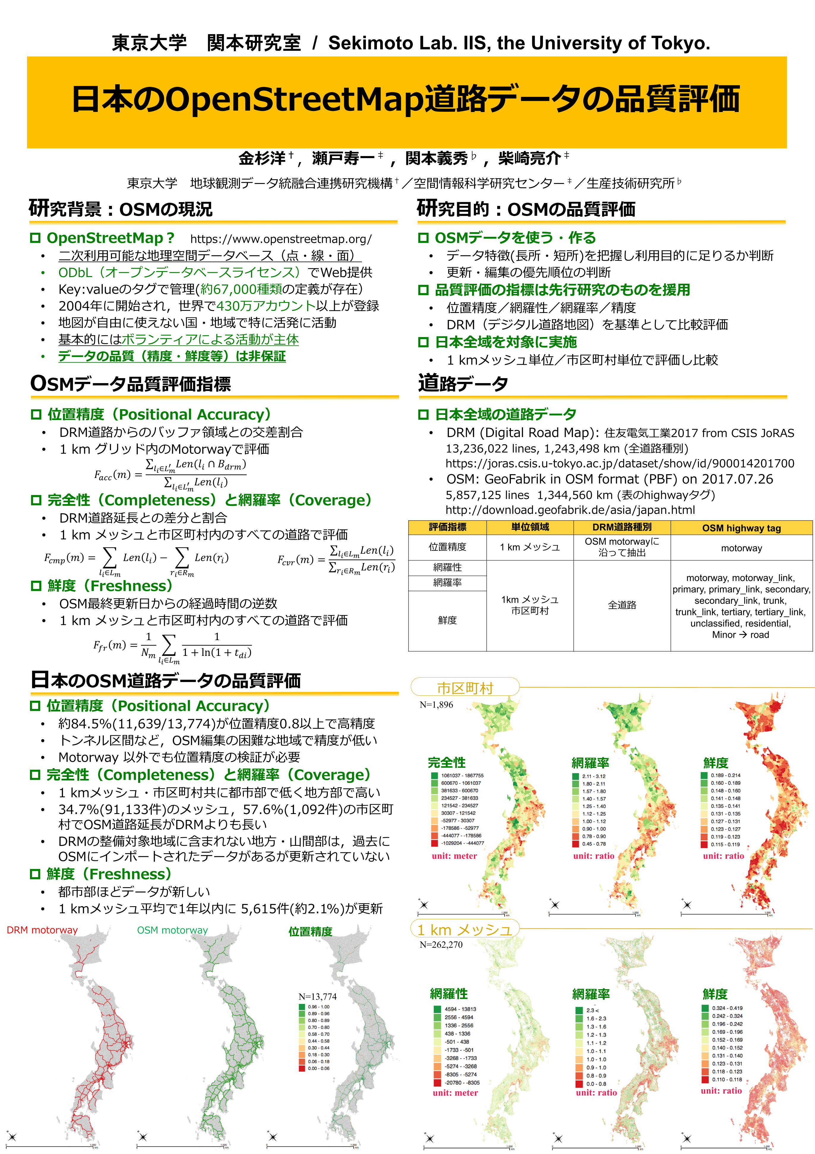
DRM motorway OSM motorway 位置精度
N=13,774
市区町村
1 km メッシュ
N=1,896
N=262,270
日本のOSM道路データの品質評価
位置精度(Positional Accuracy)• 約84.5%(11,639/13,774)が位置精度0.8以上で高精度
• トンネル区間など,OSM編集の困難な地域で精度が低い
• Motorway 以外でも位置精度の検証が必要
完全性(Completeness)と網羅率(Coverage)• 1 kmメッシュ・市区町村共に都市部で低く地方部で高い
• 34.7%(91,133件)のメッシュ,57.6%(1,092件)の市区町村でOSM道路延長がDRMよりも長い
• DRMの整備対象地域に含まれない地方・山間部は,過去にOSMにインポートされたデータがあるが更新されていない
鮮度(Freshness)• 都市部ほどデータが新しい
• 1 kmメッシュ平均で1年以内に 5,615件(約2.1%)が更新

Data Quality Assessment of OpenStreetMap Roads in Japan
東京大学 関本研究室 / Sekimoto Lab. IIS, the University of Tokyo.
Hiroshi KANASUGI†,Toshikazu SETO‡ , Yoshihide SEIMOTO♭ , Ryosuke SHIBASAKI‡
EDITORIA† / CSIS‡ / IIS♭, UTokyo
Background: OpenStreetMap
OpenStreetMap? https://www.openstreetmap.org/
• Open Geospatial Database(Point, Line and Polygon)
• ODbL(Open Database License)
• Data has Key:value attribute tags(approx.67,000 tags)
• Started at 2004, approx.4.3M accounts in the world
• Volunteers mainly edit and maintain map data
• Data Accuracy and Freshness are non-guaranteed
Purpose: Quality Assessment of OSM
Use and Edit of OSM data• Reference for Decision making with data features
• Reference to prioritize update and edit
Following the existing indexes for Assessment• Positional Accuracy, Completeness, Coverage
• DRM(Digital Road Map) is employed as ground-truth
Target Area is Entire Japan• Indexes area calculated in 1 km Grid and City Boundary
Quality Indexes Road Data: OSM & DRM
Positional Accuracy• Intersection ratio with buffered DRM motorways
• Assessment with motorway in 1 km grids
Completeness & Coverage• Difference and Proportion between total road length
• Assessment with all roads in 1 km grid and city
Freshness• Inverse number of duration time from the last update
• Assessment with all roads in 1 km grid and city
𝐹𝑎𝑐𝑐 𝑚 =
𝑙𝑖∈𝐿𝑚′ 𝐿𝑒𝑛(𝑙𝑖 ∩ 𝐵𝑑𝑟𝑚
𝑙𝑖∈𝐿𝑚
′ 𝐿𝑒𝑛(𝑙𝑖
𝐹𝑐𝑚𝑝 𝑚 =
𝑙𝑖∈𝐿𝑚
𝐿𝑒𝑛 𝑙𝑖 −
𝑟𝑖∈𝑅𝑚
𝐿𝑒𝑛(𝑟𝑖 𝐹𝑐𝑣𝑟 𝑚 = 𝑙𝑖∈𝐿𝑚
𝐿𝑒𝑛(𝑙𝑖
𝑟𝑖∈𝑅𝑚 𝐿𝑒𝑛(𝑟𝑖
𝐹𝑓𝑟 𝑚 =1
𝑁𝑚
𝑙𝑖∈𝐿𝑚
1
1 + ln 1 + 𝑡𝑑𝑖
Road data Covering Entire Japan• DRM(Digital Road Map): Sumitomo 2017 from CSIS JoRAS
13,236,022 lines, 1,243,498 km (all roads)
https://joras.csis.u-tokyo.ac.jp/dataset/show/id/900014201700
• OSM: GeoFabrik in OSM format (PBF) on 2017.07.265,857,125 lines 1,344,560 km (highway tags in the table below)
http://download.geofabrik.de/asia/japan.html
Indexes Spatial Unit DRM Road types OSM highway tag
Positional
Accuracy1 km Grid OSM motorways motorway
Completeness
1km Grid
City BoundaryAll road types
motorway, motorway_link,
primary, primary_link, secondary,
secondary_link, trunk,
trunk_link, tertiary, tertiary_link,
unclassified, residential,
Minor road
Coverage
Freshness
unit: meter unit: ratio unit: ratio
CoverageCompleteness Freshness
unit: meter
unit: meter unit: ratio unit: ratio
CoverageCompleteness Freshness
DRM motorway OSM motorway
PositionalAccuracy
N=13,774
City Bounds
1 km Grid
N=1,896
N=262,270
Results: Quality of OSM Roads in Japan Positional Accuracy• 84.5%(11,639/13,774) motorways are over 0.8
• Areas where OSM edit is difficult are low accuracy, such as tunnel
• Roads other than motorway should be assessed as well
Completeness & Coverage• Urban areas are low in both 1 km grid and city bounds
• In 34.7%(91,133 girds) and 57.6%(1,092 cities), total length of OSM roads are longer than DRM
• Rural and mountainous area outside of DRM coverage has OSM road, but has not updated for several years
Freshness• Urban area has newer data
• Only 5,615 grids(2.1%) are updated within last 1 year