portada: selva amazónica desde el cielo (foto s. rostain...
TRANSCRIPT


Portada: Selva amazónica desde el cielo (foto S. Rostain)Contraportada: Detalle del primer mapa del Amazonas, de Quito al Océano Atlántico por el Jesuita Cristóbal de Acuña para el Rey en 1642
AMAZONÍA
Memorias de las
Conferencias Magistrales del
3er Encuentro Internacional
de Arqueología Amazónica
Stéphen Rostaineditor

Amazonía.Memorias de las Conferencias Magistrales del 3er Encuentro Internacional de Arqueología Amazónica
Stéphen Rostain editor Edición: - Ministerio Coordinador de Conocimiento y Talento Humano e IKIAM - Secretaría Nacional de Educación Superior, Ciencia, Tecnología e Innovación - Tercer Encuentro Internacional de Arqueología Amazónica Diseño: Stéphen Rostain Diagramación: Stéphen Rostain ISBN: 978-9942-13-893-4 Impresión: Ekseption PublicidadImpreso en Quito, Ecuador, agosto de 2014

5
Contenido
Stéphen RostainPrefacio: “Codo a codo, somos mucho más que dos” 7
Philippe Descola¿Existen paisajes amazónicos? 19
Nigel SmithA rainforest cornucopia: the cultural importance of native fruits in Amazonia 31
Denise SchaanChronology of landscape transformation in Amazonia 51 Heiko Prümers100 años de arqueología en los Llanos de Mojos 73
Doyle McKey, Mélisse Durécu, Axelle Solibiéda, Christine Raimond, Kisay Lorena Adame Montoya, José Iriarte, Delphine Renard, Luz Elena Suarez Jimenez, Stéphen Rostain & Anne ZangerléNew approaches to pre-Columbian raised-field agriculture: ecology of seasonally flooded savannas, and living raised fieldsin Africa, as windows on the past and the future 91
Eduardo G. Neves, Vera L. C. Guapindaia, Helena Pinto Lima, Bernardo L. S. Costa & Jaqueline GomesA tradição Pocó-Açutuba e os primeros sinais visíveis de modificações de paisagens na calha do Amazonas 137
Stéphen Rostain, Geoffroy de Saulieu & Emmanuel LézyEl alto Pastaza precolombino en el Ecuador: del mito ala arqueología 159
Michael HeckenbergerTropical garden cities of the southern Amazon 187
Dimitri KaradimasLas alas del tigre: acercamiento iconográfico a una mitología común entre Los Andes prehispánicos y la Amazonía contemporánea 203
91
New approaches to pre-Columbian raised-field agriculture:
ecology of seasonally flooded savannas, and living raised fields in Africa,
as windows on the past and the future Doyle McKey1,2, Delphine Renard1,3, Anne Zangerlé4,5,
José Iriarte6, Kisay Lorena Adame Montoya7, Luz Elena Suarez Jimenez7, Axelle Solibiéda8,
Mélisse Durécu1, Marion Comptour1, Stéphen Rostain9, Christine Raimond8
1 Université Montpellier 2, Centre d’EcologieFonctionnelle et Evolutive, UMR 5175 CNRS, France
2 Institut Universitaire de France3 current address: Dept. of Geography, McGill University,
Montreal QC, Canada4 Department of Ecology and Ecosystem Management,
Technische Universität München, Freising, Germany5 Current address: Centre d’EcologieFonctionnelle
et Evolutive, UMR 5175 CNRS, France6 Department of Archaeology, University of Exeter, UK
7 Fundacion Universitaria Internacional del Tropico Americano (Unitropico), Yopal, Colombia
8 Laboratoire de Géographie, Pôle de Recherche pour l’Organisation et la Diffusion d’Information
Géographique (PRODIG), UMR 8586, Paris, France9 Institut Français d’Etudes Andines, Quito, Ecuador/
Archéologie des Amériques, UMR 8096 CNRS, Nanterre, France
Introduction
Seasonally flooded savannas, found in several regions scattered around the rim of Amazonia, today harbor very low human population densities. Over the past few centuries, production systems of people living in these environments have depended largely on the harvesting of wild resources. Today much of their area is devoted to extensive cattle ranching. Archaeological data show, however, that many of these areas have not always been so thinly populated, and that production systems in the past included forms of agriculture that may have been relatively

92
intensive, involving the construction of agricultural raised fields, paths, canals and other structures, with impacts on the landscape that can still be seen. Raised fields can be defined as “any prepared land involving the transfer and elevation of earth in order to improve cultivating conditions” (Denevan and Turner 1974). Drainage is of course not the only way in which elevating earth improves conditions for farming, and wetlands are not the only environments in which raised fields (or “raised beds”, for little-elevated structures) are found. Nonetheless, the largest and most extensive raised fields are found in wetlands. Wetland raised fields were widespread in the Americas before the European conquest (Denevan 2001; Doolittle 2000). In the Neotropics, raised-field wetland agriculture is today extinct, or present only in relictual form. Its disappearance poses numerous questions: How did it function? Why did it disappear? Could it have any relevance today? The objective of this chapter is to examine the functioning of this ancient type of agriculture. Knowing how it functioned—and in some parts of the world still functions today—is required to assess its value as a potential source of inspiration for the conception and establishment of ecologically intensive agriculture, a goal proclaimed by researchers and decision-makers alike. The chapter is organized in three parts. In the first, we briefly summarize what is known about the functioning of pre-Columbian raised-field agriculture and identify important open questions. As we will argue below, current approaches to studying raised-field agriculture in pre-Columbian South America seem to be reaching their limits. New approaches are required to resolve open questions and to suggest new questions and productive lines of investigation. In the second and third parts of the chapter, we describe two new approaches we are pursuing. In the first, we explore the present-day ecology of seasonally flooded tropical savannas. We show that insights into raised-field agriculture can be gained by a better understanding of the environments in which these agroecosystems are embedded, in particular why these environments so often harbor highly regular mound-field landscapes of natural origin that resemble some kinds of agricultural raised fields. Archaeologists have commented on this resemblance, but have simply regarded natural mound-fields as a nuisance, a confounding feature that must be distinguished from their “real” objects of study. We suggest that natural mound-fields testify to striking convergence in the adaptations of humans and other organisms to these constraining environments, and that human and natural engineers may often have worked together, producing landscapes that are neither ‘natural’ nor ‘cultural’, but biocultural in origin. Far from being just a confounding nuisance, natural mound-fields may sometimes be an essential part of the story In the second new approach, we show how exploring the ethnoecology of modern raised-field agriculture in seasonally flooded African savannas can lead not only to insights about pre-Columbian raised-field agriculture in
93
the Neotropics, but might also help us imagine more intensive forms of agriculture in the context of the rapid growth of human populations that is already affecting some seasonally flooded tropical wetlands, notably in Africa. Our ecological approach and our studies in Africa thus provide a window not only into the pre-Columbian past, but also into a hoped-for future of intensive but sustainable agriculture.
1. Ecology of pre-Columbian raised-field agriculture in South America: current state of knowledge and open questions
The history of environments and societies in lowland South America in the centuries before the European conquest is hotly contested. Much of this debate focuses on the extent and nature of human modification of environments in Amazonian forests, where anthropogenic dark earths (Glaser and Birk 2012; Glaser and Woods 2004; Lehmann et al. 2003; Woods et al. 2009; Petersen et al. 2001), evidence for settlements of substantial size (Carneiro 1960; Heckenberger et al. 1999, 2007, 2008) and evidence that humans modified the composition of forest communities (Balée and Erickson 2006; Junqueira et al. 2010; Levis et al. 2012; Shepard and Ramirez 2011) all suggest an intensification of agriculture during the late Holocene, leading to surprisingly large pre-Columbian human populations (Denevan 1992). How much of forested Amazonia was affected by this agricultural intensification is a still unsettled question (Barlow et al. 2012; Bush and Silman 2007; Clement and Junqueira 2010; Erickson 2008; McMichael et al. 2012). In peri-Amazonian savannas, another apparently intensive form of agriculture is suggested by widespread vestiges of raised fields (Denevan 2001). Different forms of raised-field agriculture were practiced in permanent or seasonally flooded wetlands in several regions in Central and South America, both in lowland environments and in the Altiplano, from as early as ca. 3000 yr BP, around Lake Titicaca in Bolivia and Peru (e.g., Erickson 1987; Kolata 1996), and up until the European conquest in several sites. The chronicles of European missionaries left scant anecdotal information on the methods farmers used to construct and manage raised fields (De Las Casas 1986 [1560]; Gondard 2008; Gumilla, 1963 (1791]).
1.1. What was the real extent of raised-field agriculture?A fundamental, but still debated, question about raised-field agriculture is how extensive it really was. Various types of mounds of natural origin frequently occur in seasonally flooded savannas, and they are often arranged in mound-field landscapes that show striking spatial regularity (Renard et al. 2012a). These mound-field landscapes resemble some kinds of agricultural raised fields, and the potential for confusing the two has led to controversy about how extensive pre-Columbian agriculture in neotropical savannas really was. One kind of natural mound-field landscape, gilgai
94
topography, has been a source of confusion in interpreting raised-field agriculture in the Mayan lowlands for almost 40 years (Puleston 1978). Baker (2003) reviewed this question, provided new evidence that both gilgai and human-constructed raised fields occur in the area, and clarified the distinction between them. In lowland South America, the kaolinite-rich oxisols of seasonally flooded savannas where we have worked in French Guiana and Colombia lack the shrinking-swelling clays necessary for gilgai formation (B. Glaser, University of Halle, pers. comm.). However, other types of mound-field landscapes exist in these environments. Writing of peri-Amazonian savannas, Meggers (2003) warned of the possibility of confusion between raised fields and spatially regular mound-field landscapes of natural origin, and presented photographs she considered to represent likely examples of the latter in the Llanos de Mojos in Bolivia. Langstroth (1996, 2011) and Mayle et al. (2007) also drew attention to the possibility of confusing artificial earth mounds with structures of natural origin, noting that some habitation mounds in the Llanos de Mojos appear to be eroded relics of natural levees and terraces, and that many smaller forest islands appear to have been created by termites, rather than humans. At least some forest islands in the region, however, are of human origin, as they are built on ancient (early Holocene) shell middens (Lombardo et al. 2013). However, aside from the counsel to exercise caution, authors have offered no guidelines on how mound-field landscapes of natural origin and vestiges of agricultural raised fields might be distinguished. Furthermore, as noted above, no one appears to have asked why various types of earth mounds of natural origin are so frequently found in the same kinds of environments where humans often constructed large complexes of similar mounds. Does the outward similarity of natural mound-fields and certain vestiges of agricultural raised fields reflect some deeper connection?
1.2. How did raised-field agriculture function?A second set of fundamental, still unresolved, questions about raised-field agriculture revolves around how it worked and how productive it really was. All authors agree that the primary function of constructing raised fields was to provide well-drained soils for flooding-intolerant crops. Other potential advantages of raised-field agriculture have been suggested, such as the recycling and concentration of nutrients, the production of aquatic resources such as fish, and (in altiplano environments) the protection of crops from frost (see Renard et al. 2012b for a review), but the importance of these potential advantages is contested (Baveye 2013; Lombardo et al. 2011). How intensive and productive this kind of agriculture really was, and whether it supported dense populations, are questions as hotly debated as those concerning Amazonian forests (Bandy 2005; Iriarte et al. 2010; Lombardo et al. 2011; Muse and Quintero 1987; Saavedra 2009).

95
An overarching problem in understanding raised-field agriculture, we believe, is that the artifacts archaeologists can observe mostly document only a single component of subsistence systems that likely included numerous activities (cf. Bruno [2014], who independently reached the same conclusion). A striking exception is the vestiges of earthen fish weirs that document an ancient landscape-scale fishery in the Llanos de Mojos (Erickson 2000). Even where such artifacts are present, it may be difficult to estimate the place that was occupied by raised-field agriculture in these multi-component systems. Like present-day inhabitants of seasonally flooded African savannas (see section 3), perhaps pre-Columbian “raised-field farmers” considered themselves primarily fishermen, and farmed not only wetlands, but also other habitats over the annual cycle. “Raised-field agriculture” should be understandable only when it is placed in a broader context of a more complex subsistence system. Given that we do not really understand why raised-field agriculture was abandoned, there is also uncertainty about how sustainable it was. There is also disagreement about the related question of whether raised-field agriculture has any relevance as an intensive, ecologically sustainable, form of agriculture today. Based on the sheer extent of raised fields in some areas, archaeologists have argued that they must have supported sizable human populations. Denevan (1982) estimated the total surface of raised fields known at that time in Latin America to be 1000 km2 (100,000 ha), representing more than a billion cubic meters of earth moved. However, this is surely an underestimate, as Erickson (1992a) estimated 80,000 ha of raised fields in the Lake Titicaca basin alone. Furthermore, some archaeologists consider that raised-field agriculture was quite productive, supporting high population densities. Erickson and Candler (1989) estimated that raised fields in the Lake Titicaca basin could have supported 37.5 persons per ha. This corresponds to over 3700 persons per km2! Rostain (2008) proposed a figure of 50-100 inhabitants per km2 (still a high density for agricultural lands) during the period of raised-field farming in the coastal savannas of the Guianas. As occupancy of many sites appears often to have been continuous over centuries, or in some cases over a millennium or more (e.g., Erickson 1995; Walker 2004), this use of the land appears to have been sustainable. These researchers hold that sustained productivity, in climates and soils that today are widely regarded as quite unsuited to agriculture (Erickson 1994b), must have been based on deft management not only of drainage, but also of nutrients. In this view, aquatic resources such as fish, and nutrient input from sediments and organic matter accumulated in the flooded basin in which raised fields are embedded, are key components of these systems, along with other sources of nutrients such as weeds and kitchen scraps. The chinampas of the Valley of Mexico are particularly emblematic, and management practices like those of chinamperos are
96
thought by some to have been widespread in other areas where raised-field agriculture was practiced. Based on such assessments, geographers, archaeologists and other scientists have advocated raised-field agriculture as a promising way forward in the search for ecologically sustainable intensification of agriculture (Denevan 1995, 2001; Erickson 1992a; Morris 2004; Saavedra 2009; Siemens 2004) and as a kind of agriculture that can work with wetlands and their biodiversity, rather than against them (McKey et al. 2010; Renard et al. 2012b). Some of these scientists have attempted to bolster their claims with experiments in reconstructing or rehabilitating raised-field agriculture (Barba et al. 2003; Erickson 1992a, 1994a, b, 1995; Gomez-Pompa et al. 1982; Morris 2004; Saavedra 2009).Others are highly skeptical of these interpretations (Bandy 2005; Baveye 2013; Lombardo et al. 2011; Swartley 2002). First, whereas the start of raised-field cultivation in an area can be dated, it is usually impossible to estimate when farmers stopped their activities on raised fields. Thus, the duration, and hence the potential sustainability, of raised-field farming is often uncertain. Second, the extent of vestiges of raised fields may say little about the size of the human populations they could have supported. If fallow periods were long, for example, then only a small fraction of the total area may have been under cultivation at a particular point in time. Similarly, varying hydrological conditions may have permitted cultivation in only a small part of the landscape at a given time (the ‘shifting lakeshore’ hypothesis [Baveye 2013]). According to this view, if these systems were sustainable, this may have been only because the pressure on resources was held low, by low densities of humans shifting over the mosaic landscape in time. Skeptics are particularly critical of experiments that have attempted to reconstruct or rehabilitate raised-field agriculture, pointing out methodological shortcomings (Lombardo et al. 2011; Swartley 2002). Skeptics believe that in many systems, the advantage of constructing raised fields is purely drainage (and to a lesser extent, irrigation), and that other potential advantages, such as nutrient management or the use of aquatic resources, have been overestimated (Lombardo et al. 2011). According to this view, apart from the chinampas, to be discussed in section 1.3.1, raised-field agriculture is an irredeemably failed system with little relevance to agriculture today or in the future (Bandy 2005; Chapin 1988).
1.3. Current approaches to studying the functioning of raised-field agriculture, and their limitsHow can these debates be resolved? Inferences about the functioning of raised fields in the past, and their agronomic potential in the present, have been based on three kinds of data.
1.3.1. The chinampas as a model systemThe only system still extant in the neotropics, the chinampas of the Valley of
97
Mexico (Armillas 1971), has influenced much of our thinking on how past systems may have worked elsewhere in the Americas (see Lombardo et al. 2011 for review). However, the chinampas have been greatly altered over the past 500 years (Merlin-Uribe et al. 2012; Torres-Lima et al. 1994). Even in their ‘original’ state they probably functioned very differently from other forms of neotropical wetland agriculture. These differences lie partly in the biophysical environment. In contrast to most raised-field systems, the chinampas are located at mid-elevation, and not in the hot lowlands; and their soils, shaped by both volcanic and alluvial/lacustrine influences, are richer than the acid, highly weathered Oxisols that characterize many other sites (Renard et al. 2012b). The chinampa system is also characterized by unique agricultural practices, such as the historic stabilization of platforms by the planting of flooding-tolerant trees such as willows, and—at least in pre-Conquest times—by the transport of floating beds of seedlings to plant the platforms (Armillas 1971). Chapin (1988), Lombardo et al. (2011) and Baveye (2013) regard the chinampas system as unique and claim that archaeologists have abusively overgeneralized this model.
1.3.2. Data from geoarchaeologyGeoarchaeological methods can provide data to support inferences about agricultural practices and how they could have affected the functioning of raised-field agroecosystems. Coprostanols in archaeological sediments and soils, for example, yield information on fertilization by animal manure (Birk et al. 2011). Micromorphological data suggest animal manuring of raised-field soils in the Guayas Basin, Ecuador (Wilson et al. 2002). However, while geoarchaeological methods may provide highly suggestive evidence, it is often inconclusive; alternative interpretations are often possible. For example, finding carbonized seeds of wild plants in soils of raised fields could indicate that fields may have been fertilized with llama dung containing these seeds (Erickson 1994a), but it could also be explained by burning of weeds gathered from agricultural fields (Gondard 2006). Furthermore, geoarchaeological methods appear to be silent on many important questions about raised fields. They lack, for example, the resolving power in space and time to enable us to assess whether raised fields were continuously cultivated or subjected to more or less long fallow periods.
1.3.3. Experiments in reconstructing or rehabilitating raised fieldsAttempts to experimentally reconstruct or rehabilitate raised fields can offer important insights into how raised-field systems might function. For example, Erickson (1992b) found that during the El Niño drought of 1982-1983 in the Lake Titicaca Basin, there was still enough water in canals to splash irrigate experimental raised fields, whereas nearby non-raised fields completely failed. Similarly, during severe floods in 1985-

98
1986, raised fields yielded well, whereas non-raised fields were flooded and produced nothing. However, for many of the experiments conducted so far, methodological limitations affect interpretation of their results. First, their duration may simply be too short to allow conclusions. Changes in soil properties associated with raised-field construction (e.g., salinity in soils of the Lake Titicaca basin) may have led to initial, but short-lived, benefits in experimental raised fields (Baveye 2013). Second, some experiments had design flaws. In Tabasco (Gulf coastal lowlands of Mexico), raised platforms were constructed using earth-moving machinery that brought poorer subsoil to the surface, burying the richer topsoil and compacting the soil (Chapin 1988). However, perhaps the most serious limitation of many experiments is that they attempt to answer simultaneously two questions that in fact require different kinds of experiments (Baveye 2013). All these experiments have as one announced goal to learn how raised-field agroecosystems functioned, in the past. But another goal, only sometimes explicit, is to demonstrate that they could be agronomically, and economically, interesting today. Because socio-cultural contexts today are different from how we imagine they were in the past, experiments often “fail” for reasons that have nothing to do with their ecological functioning, for example, the absence of provisions for marketing the crop once it is produced (Chapin 1988). In consequence, results of these experiments sometimes tell us little about the agroecology of raised-field systems. In experiments that attempt to rehabilitate this type of agriculture in regions where knowledge about it has been lost, it is impossible to know how well the experiments replicate the ecological conditions and the plants of these environments, the technical practices employed in constructing and maintaining raised fields (and their costs in terms of labor), and the social organization that characterized pre-Columbian farmers. Overall, experimental raised fields have failed, in the sense that these experiments all appear to have been abandoned, but how much of this failure can be ascribed to agroecological limitations of raised-field agriculture (Bandy 2005; Baveye 2013) or to social or cultural factors (Erickson 1994b) is unclear. Like other approaches used to study the functioning of raised-field agriculture up to now, experiments to reconstruct or rehabilitate raised fields seem to have reached at least a temporary limit. It is time for new approaches.
2. Placing raised-field agriculture in the context of the ecology of seasonally flooded savannas
The first new approach we present explores what we can learn by considering raised-field agriculture within the more general context of the ecology of seasonally flooded savannas. Long before the arrival of humans on the scene, plants, animals and microorganisms adapted to
99
these highly constraining environments, and the interplay between the living and non-living parts of the ecosystem shaped the biophysical setting in which raised-field agriculture became enmeshed. We are just beginning to understand the interactions that resulted.
2.1. Ecology of raised-field landscapes in the coastal savannas of French Guiana: feedback loops in the vestiges of raised-field agricultureOur work on this approach began in a multidisciplinary study of the vestiges of raised-field agriculture in the coastal savannas of French Guiana. Building on the pioneering work of Rostain (1994, 2008, 2010, 2012), our work yielded new information on the history of these environments and the people who inhabited them, providing data on when they were cultivated, what crops were grown on them and how raised-field landscapes were constructed and managed (Iriarte et al. 2010, 2012; McKey et al. 2010). The earthworks in these savannas were built by groups of the Arauquinoid tradition, who spread progressively from their origin in the Apure–Middle Orinoco region eastward along the Guianese coast beginning around AD 600. Increases in the surface area of raised fields in the lowlands of Venezuela, Guyana, Suriname, and French Guiana marked the eastward advance of Arauquinoid populations. In French Guiana, 14C dating of organic material extracted from the tops of the paleosols buried under mounds in two complexes west of Kourou gave ages of 760 ± 40 years BP (calibrated, 670–700 years BP) and 1,010 ± 40 years BP (calibrated, 920–950 years BP) respectively (McKey et al. 2010). Other ages are 1,060 ± 30 years BP (calibrated, AD 898–1022) in Bois Diable raised fields and 620 ± 30 years BP (calibrated, AD 1289–1404) in the Matiti savanna raised fields. These dates correspond to those obtained from the sites of Arauquinoid tradition on the west coast of French Guiana and from the eastern coast of Suriname, supporting the attribution of the raised fields to the Arauquinoid groups that inhabited the sand ridges bordering the mound complexes, where huge archaeological sites of this tradition have been found (Rostain 2012). Form and organization of the Arauquinoid raised-field complexes varied through time and space, in relation to cultural, chronological, and technological differences, and to variation in local hydrological and edaphic factors (Figure 1). The construction of raised fields in the Guianas corresponded to a period of extremely humid climatic conditions (Colinvaux 1989), which may have favored the expansion of raised-field techniques. In French Guiana alone, almost 3,000 hectares of human-modified savannas have been mapped. These figures include only areas documented by the ecofacts that are still visible; it is likely that entire complexes have been destroyed by modern land use. Agricultural activities, highways and other construction projects have buried mounds. In Suriname and Guyana, thousands of hectares of
100
colonial polders have completely erased many pre-Columbian structures.Our concern here, however, lies less with the history of these structures than with their ecology. We studied how the vestiges of these ancient agricultural landscapes function as ecosystems today. Our results suggest something about how the raised-field agroecosystem may have functioned when these sites were under active cultivation.
2.1.1. The ecological legacy of raised-field agriculture in French Guianan coastal savannasIn the best-studied of our sites in French Guiana, the Grand Macoua Savanna, the old raised fields are small earth mounds only about a meter in diameter and 20-30 cm in height. Evidence from phytoliths and from carbon stable isotope composition in soil profiles indicates that before these mounds were built, the area was covered with relatively homogeneous marshland vegetation with relatively flat topography (McKey et al. 2010; Renard et al. 2012a). After raised fields were abandoned by humans, 500 years or more ago, the landscape did not return to that initial condition. Our investigation of the ecological legacy of pre-Columbian raised-field agriculture began with a simple question: why are the physical vestiges of raised fields still so clearly present today, despite their having been subjected during all this time to the erosive effects of up to 3-4 m of tropical rainfall each year? Our results showed that raised fields, after being abandoned by humans, were re-engineered by soil engineer organisms such as ants, termites, earthworms and plants (McKey et al. 2010; Renard et al. 2013). Soil engineers are a subset of organisms considered by ecologists to be “ecosystem engineers”—organisms that create, maintain, modify or destroy habitats, affecting the conditions of life for themselves and for other organisms (Jones et al. 1994). We found that in the landscapes we studied in French Guiana, activities of soil engineer organisms were concentrated in the well-aerated soils of the abandoned raised fields. In these ancient agricultural landscapes, nests of social insects are restricted to mounds. These central-place foragers continually bring organic matter to their nests. Furthermore, during nest excavation and cleaning, they carry subsoil to the surfaces of mounds. Furthermore, during the rainy season earthworms concentrate in mounds, where they can respire, and thus their casts are also concentrated on mounds (Figure 2). The organic and mineral material all these organisms bring to mounds compensates for losses by erosion. In addition, the biogenic structures—nests, galleries and water-stable aggregates—created by social insects, earthworms and plant roots stabilize the soil of mounds against erosion. The macropores created by these organisms favor the infiltration of rainwater rather than runoff, further reducing the rate of erosion.
101
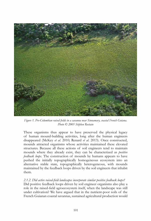
Figure 1. Pre-Columbian raised fields in a savanna near Sinnamary, coastal French Guiana. Photo © 2005 Stéphen Rostain
These organisms thus appear to have preserved the physical legacy of human mound-building activities, long after the human engineers disappeared (McKey et al. 2010; Renard et al. 2013). Once constructed, mounds attracted organisms whose activities maintained these elevated structures. Because all these actions of soil engineers tend to maintain mounds where they already exist, they can be characterized as positive feedback loops. The construction of mounds by humans appears to have pushed the initially topographically homogeneous ecosystem into an alternative stable state, topographically heterogeneous, with mounds maintained by the feedback loops driven by the soil engineers that inhabit them.
2.1.2. Did active raised-field landscapes incorporate similar positive feedback loops?Did positive feedback loops driven by soil engineer organisms also play a role in the raised-field agroecosystem itself, when the landscape was still under cultivation? We have argued that in the nutrient-poor soils of the French Guianan coastal savannas, sustained agricultural production would

102
Figure 2. Vestiges of pre-Columbian raised fields in French Guiana and biogenic structures of some of the ecosystem engineers that maintain them. A: Part of the vast complex of
abandoned raised fields in the Grand Macoua Savanna in the rainy season (April 2007). Only the abandoned raised fields are above water level. B: Abandoned raised field in the
dry season, totally covered with earthworm casts, absent from the surrounding matrix. Note higher plant density on the abandoned raised field. C, D: subsoil from nest excavation or
cleaning by ants, deposited near nest entrances (on abandoned raised fields). C: Acromyrmex octospinosus; D: Ectatomma brunneum; E: Surface of a typical abandoned raised field, completely constituted of stable earthworm-produced biogenic structures. F: Material
associated with an Acromyrmex octospinosus nest on an abandoned raised field. Light brown material covering the top of the mound is excavated soil, yellow-brown material at
center bottom is plant debris deposited from the ants’ fungal farm.Scale bars are approximate. Photos © 2007 Doyle McKey.
Photos A, B, E and F were previously published in McKey et al. (2010)

103
have been possible only through careful management of soil organic matter (SOM). This required fallow periods that allowed the reconstitution of SOM. Geoarchaeological evidence indicates that fallows may have been managed by a slash-and-mulch system (rather than slash-and-burn) that conserved SOM (Iriarte et al. 2012). We postulate that soil engineers maintained topographic heterogeneity and favorable soil structure during fallows, enhancing their efficiency in restoring SOM. In effect, farmers “outsourced” the work of maintaining the land during fallows to soil engineers, reducing the time and labor costs of maintaining raised fields during fallows and of reconstructing them afterwards (McKey et al. 2010). This is probably only a particularly conspicuous example of the multiple roles—often poorly understood, unheralded, but nonetheless essential—that interactions among soil organisms play in reconstituting fertility during fallows in many kinds of agroecosystems.
2.2. Mound-fields of natural origin: when feedback loops lead to spatial self-organization of ecosystems The feedback loops that drive the maintenance of raised fields after their abandonment by humans result from the responses of soil engineer organisms to a strong environmental constraint: the seasonal scarcity of a key resource, namely well-aerated soils. This constraint characterizes all seasonally flooded savannas. It is thus not surprising that many organisms other than humans have evolved the capacity to build elevated structures in these environments, concentrating this key resource in patches within an otherwise inundated landscape. Numerous kinds of earthworms and social insects, in particular, build elevated structures in seasonal wetlands and exploit the well-aerated soils thereby produced (Renard et al. 2012a). Interestingly, the landscapes thus created show striking regularity—just as in raised-field landscapes—in the spatial organization of mounds. However, whereas in the vestiges of raised fields soil engineers simply maintain a pattern created by humans, in natural mound-fields spatial regularity is not planned, but instead emerges from natural processes that incorporate feedback loops, most often the combined actions of individual soil engineers. The mechanisms that produce such emergent regularity can be termed self-organizing. Ecologists have long been fascinated (e.g., Bates 1948) by the “patterned landscapes” produced by self-organizing mechanisms, and recent theoretical and empirical studies have helped us understand how they form. Most of this work has focused on explaining regular spatial patterns in vegetation of semi-arid regions (Meron 2012; Rietkerk et al. 2004). The key principles behind spatial self-organization in these ecosystems, developed by theory and supported by empirical studies, are that (i) the ecosystem is characterized by some key resource in short supply, (ii) engineer organisms

104
modify the distribution of that resource, (iii) concentrating it in patches, with resource-poor areas between these patches. In semi-arid shrublands, the key resource is water, and plants modify its distribution. We will return to this example in section 2.3.Mound-field landscapes in seasonally flooded tropical savannas have never been studied from this point of view. Why is it important for archaeologists interested in raised fields to understand the ecology of natural mound-field landscapes? They appear to have been built by various soil engineer organisms. If the evolution by soil engineers of the capacity to build such structures has been driven by the same environmental pressures that led humans to construct raised fields, we might also expect to see similarities in the way natural and man-made mound-field landscapes function. Furthermore, where humans have constructed raised fields, these engineers and their structures are also often present, and a great range of interactions may occur. It thus becomes very important, in the study of raised-field agriculture, to understand the biology of soil engineers, their effects on ecosystems, and how they might interact with humans. We decided to investigate these questions in the Orinoco Llanos of Colombia, certain parts of which feature enormous expanses of natural mound-field landscapes termed surales.
2.2.1. Ecological studies in the surales (Colombia)Surales are one of the poorly studied types of mound-field landscapes found in seasonally flooded South American savannas (Renard et al. 2012a). They occur mostly in the alluvial overflow plain of the Orinoco Llanos from the Apure River in Venezuela to the Meta River in Colombia (Sarmiento and Pinillos 2001). Regarding their origin, some ecologists have affirmed, rather matter-of-factly, that the mounds are constructed by earthworms (Chacón-Moreno et al. 2004; Sarmiento and Pinillos 2001), whereas others, equally matter-of-factly, affirm that they are built by termites (Beard 1953). No one has pursued the question of the origin of these mounds in any detail, failing even to identify the kind of earthworm, or termite, held to be the mound-builders. Most surprisingly, no serious attempt has been made to explain the extreme spatial regularity of mounds in surales landscapes. Bates (1948, pages 566 and 568) provides a vivid description of surales: “The surales present a reticulate pattern of deep ditches surrounding mounds a meter or two in diameter; the top of the mound is a meter or more above the bottom of the surrounding ditch. … The reticulate ditching is like the pattern formed by the drying of a gigantic mud flat. … Well-developed sural country is difficult to traverse. If you are on foot, you have to decide whether to follow the endless twistings of the boggy ditches or to jump from mound to mound, both awkward expedients. If you are mounted, the animal has to make the same decision and generally ends up in complete frustration: I have heard stories of man and mule firmly stuck in a narrow, deep ditch between two
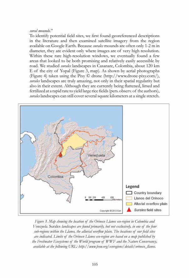
105
sural mounds.” To identify potential field sites, we first found georeferenced descriptions in the literature and then examined satellite imagery from the region available on Google Earth. Because surales mounds are often only 1-2 m in diameter, they are evident only where images are of very high resolution. Within these rare high-resolution windows, we eventually found a few areas that looked to be both promising and relatively easily accessible by road. We studied surales landscapes in Casanare, Colombia, about 120 km E of the city of Yopal (Figure 3, map). As shown by aerial photographs (Figure 4) taken using the Pixy © drone (http://www.drone-pixy.com/), surales landscapes are truly amazing, not only in their spatial regularity but also in their extent. Although they are currently being flattened, limed and fertilized at a rapid rate to yield large rice fields (pers. observ. of the authors), surales landscapes can still cover several square kilometers at a single stretch.
Figure 3. Map showing the location of the Orinoco Llanos eco-region in Colombia and Venezuela. Surales landscapes are found primarily, but not exclusively, in one of the four sub-regions within the Llanos, the alluvial overflow plain. The locations of our field sites are indicated. Limits of the Orinoco Llanos eco-region are based on a map published by
the Freshwater Ecosystems of the World program of WWF and the Nature Conservancy, available at the following URL: http://www.feow.org/ecoregions/details/orinoco_llanos.

106
Limits of the alluvial overflow plain are based on a map published in Sarmiento (1983)
Figure 4. Aerial images of surales landscapes, taken using the Pixy© drone.Scale bars are approximate. Photos © 2012 Delphine Renard
Our studies of these ecosystems are still in their early days, but a few tentative conclusions can be summarized here. First, in line with most earlier ecological studies of surales landscapes, our observations implicate earthworms as the mound-builders. Fresh earthworm casts literally cover

107
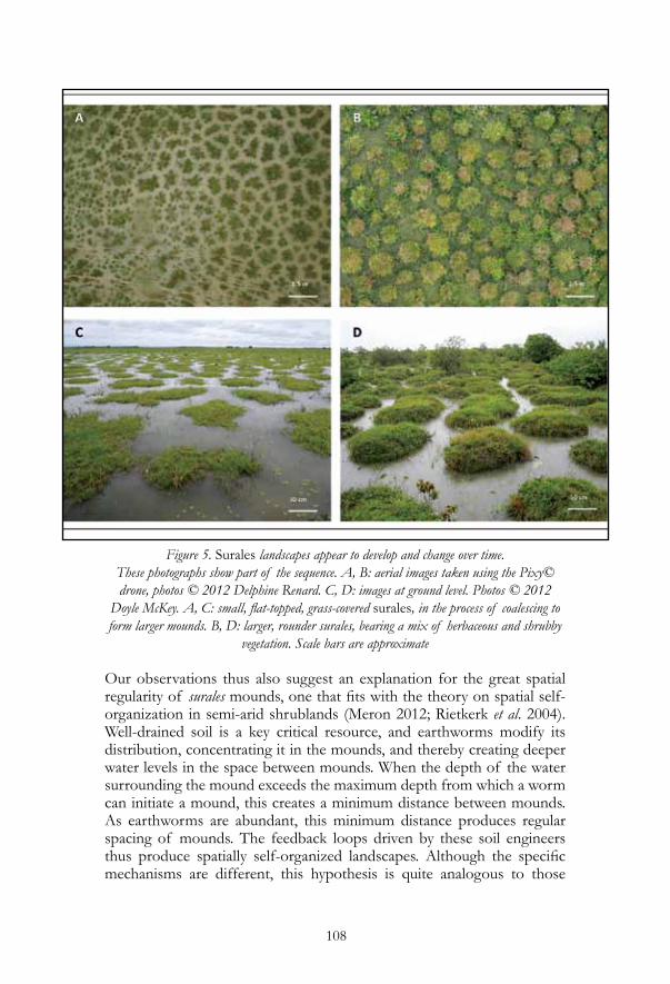
the surface of surales mounds, and mounds seem in fact to consist largely of the accumulated excreta of earthworms. A single large earthworm species appears to be the builder of surales mounds in Colombia. This earthworm, an undescribed species of Andiorrhinus (subgenus Turedrilus; Glossoscolecidae), cannot yet be described scientifically because all individuals collected so far are juveniles (A. Feijoo Martinez, Universidad Tecnológica de Pereira, pers. comm.)! We have not yet measured the density of these worms, nor the amount of earth that each worm can move daily, but this amount is certainly much greater than for the unspecialized worms we found in French Guianan abandoned raised fields. Secondly, our work reveals geomorphological diversity among surales landscapes, and suggests that this diversity represents an ecological succession, across which there is change not only in the communities of organisms, but also dramatic change in the development and functioning of the ecosystem. In ditches lining an airstrip constructed 10 years before our work began, we observed the probable very first step in this successional process: worm towers and small mounds constructed in this recently created flood-prone area. In other areas where mounds appeared to be relatively young, they were small in diameter (< 1 m), flat-topped, barely protruding above the rainy-season high-water level, and bearing only grass and other herbaceous vegetation (Figure 5A, C). Clusters of these small mounds coalesce to form larger mounds, still low in stature but with multiple tops. Other areas bear what appears to be the next step in succession, with round-topped mounds bearing perennial bunchgrasses and a few shrubs and small trees (Figure 5B, D). The coalescence and growth in height of mounds appear to continue, for in yet other areas we have observed mounds up to 4.5 m in diameter, covered with trees, and with up to 2 m difference in elevation from the top of mounds to the bottom of the intervening basin. Our observations suggest why natural mound-field landscapes are frequent in seasonally flooded savannas. Many kinds of organisms—in South American examples, particularly earthworms and termites—have hit upon a similar adaptive solution as humans to the principal constraint of these ecosystems, the scarcity of well-aerated soils. These organisms build towers, and eventually mounds, to enable them to live in habitats lacking this crucial resource. In the case of the surales, in areas where rainy-season water depth is sufficiently shallow, earthworms feed in flooded soil and construct towers where they can gain air to breathe. Each worm appears to forage over a limited radius in the flooded soil, continually returning to the tower to deposit its excreta and to breathe. As more and more soil from the surrounding flooded area is carried to the tower, it grows to become a mound, and small mounds grow and coalesce into larger ones (Figure 5B, D). Throughout the entire process, as the mounds get taller, the basin appears to get deeper, for the larger the mounds, the deeper the water is in the basin.
108
Figure 5. Surales landscapes appear to develop and change over time. These photographs show part of the sequence. A, B: aerial images taken using the Pixy© drone, photos © 2012 Delphine Renard. C, D: images at ground level. Photos © 2012
Doyle McKey. A, C: small, flat-topped, grass-covered surales, in the process of coalescing to form larger mounds. B, D: larger, rounder surales, bearing a mix of herbaceous and shrubby
vegetation. Scale bars are approximate
Our observations thus also suggest an explanation for the great spatial regularity of surales mounds, one that fits with the theory on spatial self-organization in semi-arid shrublands (Meron 2012; Rietkerk et al. 2004). Well-drained soil is a key critical resource, and earthworms modify its distribution, concentrating it in the mounds, and thereby creating deeper water levels in the space between mounds. When the depth of the water surrounding the mound exceeds the maximum depth from which a worm can initiate a mound, this creates a minimum distance between mounds. As earthworms are abundant, this minimum distance produces regular spacing of mounds. The feedback loops driven by these soil engineers thus produce spatially self-organized landscapes. Although the specific mechanisms are different, this hypothesis is quite analogous to those

109
that explain spatial self-organization in semi-arid shrublands (e.g., Meron 2012; Rietkerk et al. 2004) and “mima” mound-fields created by burrowing mammals (Gabet et al. 2013). Our observations in the surales also suggest a further question: Given the great advantage conferred by mound-building in these environments, why are mound-fields of natural origin not present in all seasonally flooded savannas? For example, in the coastal savannas of French Guiana there is no evidence for extensive mound-fields of natural origin. This is in strong contrast to the Orinoco Llanos, where surales are frequent, and to the Llanos de Mojos in Bolivia, where termites and earthworms have constructed distinct kinds of mound-field landscapes as spectacular as the surales (Haase and Beck 1989). Why is it that soil engineers in French Guianan coastal savannas have not created natural mound-field landscapes, but appear to have required an initial boost from humans, whose abandoned mounds they now maintain? We hypothesize that such differences between regions can be explained by history. Seasonally flooded savannas have probably existed in the Llanos de Mojos and the Orinoco Llanos since their origin as subsidence basins to the east of the uplifting Andes about 20 million years ago (Iriondo 2004; Sarmiento and Pinillos 2001). These large, geologically older savannas harbor organisms with specialized adaptations to seasonal flooding. The mound-building earthworm of the surales may be an example. Earthworms usually avoid waterlogged soil (Edwards and Bohlen 1996), and “aquatic” earthworms inhabiting marshes or swamps tend to be highly specialized (e.g., Maina et al. 1998). We postulate that in the coastal savannas of French Guiana—small, of recent (Holocene) origin and distant from other similar environments—there has simply not been enough time and space for organisms to evolve specialized adaptations to seasonal flooding. The earthworms and termites present there move soil at lower rates. Incapable of building large mounds in flooded landscapes, they require an initial boost. They can only maintain mounds that were constructed by humans, and can do this only where conditions favor their activity.
2.2.2. Natural mound-field landscapes: a nuisance or an opportunity?Up to now, students of raised-field agriculture have treated natural mound-field landscapes in seasonally flooded savannas as simply a source of confusion to be avoided. Our investigation of natural mound-field landscapes suggests that they have in fact, as Meggers (2003) suspected, sometimes been confused with vestiges of raised fields. However, instances of such confusion go in both directions. Vestiges of raised fields in French Guiana were long supposed by ecologists to be natural mound-field landscapes, and this slowed their recognition and their study. On the other hand, Reichel-Dolmatoff and Reichel-Dolmatoff (1974) appear to

110
have mistaken surales in the Colombian Llanos for vestiges of raised fields, apparently basing their conclusion solely on the assumption that their spatial regularity indicated their artificial character. As we have seen, this assumption must be questioned. However, such instances are exceptional and so far have not greatly (or at least, not durably) affected estimates of how extensive pre-Columbian raised-field agriculture was. Many vestiges of raised fields include structures such as long, parallel rectilinear or curvilinear ridges, features for which there still appear to be no plausible explanation (at least in the essentially flat landscapes of seasonally flooded savannas) other than a man-made origin. Confusion is only likely with the vestiges of one kind of raised fields, those that were built as round mounds (Figure 1). Even in these cases, and even in the absence of direct archaeological, geoarchaeological or archaeobotanical evidence, there are often differences (discussed in Renard et al. 2012a) indicative of human or natural origin of mounds. Rather than a nuisance, natural mound-fields may be a great opportunity. Their frequent presence in seasonally flooded ecosystems, sometimes in close proximity to pre-Columbian raised fields, raises a host of interesting new questions about the functional similarities between natural and man-made mound-fields (whether cultivated, in fallow, or abandoned), and about how natural engineers may interact with raised-field agriculture.
2.3. Interactions between natural engineers and raised-field farmers: new perspectivesJust as soil engineers appear to have maintained human-created mounds during fallows (McKey et al. 2010), they may have had other effects on raised-field agriculture, both in fallows and in active fields. Natural soil engineers have had millions of years to produce adaptive solutions to ecological constraints that are also faced by farmers in these environments. Mound-building may be only the most conspicuous of such adaptations. If micro-organisms of these habitats, for example, are particularly adapted to waterlogged, anaerobic soils, or to soils that are frequently moved between waterlogged and aerobic conditions, then their actions may have contributed in unsuspected ways to the functioning of raised-field agriculture. We argue that soil engineers in geologically older savannas have evolved particularly specialized adaptations to seasonal flooding. If this is so, then the effects they have on raised-field agriculture may also be greater than in younger savannas such as those of coastal French Guiana. In environments such as the Llanos de Mojos, specialized soil engineers may have driven even greater synergies between natural and cultural processes than we postulate occurred in French Guiana. For example, soil engineers such as termites in the Llanos de Mojos not only construct their own mounds, they also—like soil engineers in French Guiana—profit from human-made elevated structures, building their nests preferentially on

111
abandoned raised fields (see Plate 14b in Denevan [1966]). Because the rates at which specialized engineers move earth is likely to be much greater than in French Guiana, their effect on maintaining abandoned fields against erosion will be greater. Synergies between soil organisms and human engineers may not have been restricted to effects on topography, but may also have touched less conspicuous domains such as the physical or chemical traits of soil environments. Once we recognize that raised-field farmers and mound-building natural soil engineers sometimes coexisted in seasonally flooded savannas, other kinds of relationships between them become imaginable. In constructing raised fields, did humans attempt to imitate self-organized landscapes of natural origin? Are humans aware of the ecological mechanisms acting in these landscapes? Does the establishment of engineered landscapes in wetlands, marked by raised fields and other engineered structures, as well as the incorporation of natural structures, correspond to a deliberate project of societies (cf. Kolata 1993)? Or, alternatively, is the organization of the landscape an emergent property resulting from the actions—not explicitly coordinated—of individuals or groups of individuals (cf. Erickson 1992a)? What strategies, explicit or otherwise, are adopted by the people inhabiting these environments to modify them to their ends? Are raised-field agroecosystems an example of biomimicry, conscious or otherwise, at the ecosystem level?Semi-arid ecosystems in the Sahel of West Africa offer an example of such biomimicry. This region features various types of spatially self-organized shrubland vegetation. Here, water is the key resource, and engineer organisms (here, plant roots) modify its distribution. Soil bare of vegetation is often encrusted and impermeable to water, but where plants are present, their roots create porous, permeable soil. Rain falling on bare soil runs along the encrusted surface until it reaches a plant, where it infiltrates into the soil. Plants thus concentrate rainfall in the sites where they already occur, creating patches of vegetation (spots [“leopard bush”] on flat ground, stripes [“tiger bush”] on slopes) separated by regular distances (determined by competitive interactions) from other patches (see Meron [2012] for a detailed explanation). In this region, local farmers have developed a type of agroecosystem, the zaï system, that integrates these same self-organizing mechanisms. Zaï was devised to rehabilitate areas that had become devegetated and were thus covered with crusted, impermeable soils. Whereas many rehabilitation efforts focused on destroying soil crusts, the zaï system uses crusted soil to concentrate rainfall (Roose et al. 1999), as does the region’s natural shrubland vegetation. In the zaï system, regularly spaced holes (or, on sloping soil, regularly spaced strips along the contour) are dug and filled with organic matter-rich material, and then planted. Key to the functioning of the system is that the soil between the holes is not plowed or hoed,

112
but left in its encrusted state. Thus, rainwater falling on it flows over the surface until it reaches the porous soil of the holes bearing plants, exactly as occurs in the “leopard bush” and “tiger bush” patterned landscapes of the region. Whether raised fields function in ways similar to natural mound-field landscapes in flooded savannas cannot be known until we know much more about how each of these kinds of ecosystems works. For both raised fields and natural mound-fields, what we know about how they function boils down to little more than how their topography is produced and maintained, and even about this basic aspect little is known with certainty. Our studies of patterned mound-field landscapes of natural origin are in their infancy. In drawing them to the attention of archaeologists, we emphasize the necessity to examine the different features of each landscape before concluding on their natural or human origin. However, we believe our most important message lies elsewhere: natural mound-field landscapes are not just a deceptive nuisance that archaeologists must avoid, they are an important, and in some cases perhaps essential, part of the story. Understanding how they function can help us understand agriculture in these environments. The soil engineers that construct them may have enhanced the functioning of raised-field agroecosystems. In ways that we are just beginning to realize, these agroecosystems may have been truly co-constructed by human and non-human soil engineers.
3. Present-day systems of raised-field agriculture as living analogues of pre-Columbian systems
A second new approach we are following is to study systems that are analogous to pre-Columbian raised-field agriculture but still extant today. Archaeologists have frequently studied modern analogues to gain insight into the past (Carneiro and Kramer 1979; Hurtado and Hill 1989; Politis 2009). Societies living in environments that share similar strong constraints often develop similar adaptive solutions. Caution must be exercised, because environment influences, but does not determine, cultural adaptations. However, even imperfect analogies can be instructive. Studying modern analogues can help us understand how pre-Columbian raised-field agriculture may have functioned, as well as how and why most such systems disappeared and why others (e.g., the chinampas) were maintained. Studying how real, living systems of raised-field agriculture work today is particularly important for accomplishing our second objective, i.e., assessing the potential role of raised-field agriculture in today’s world. Forty years ago, the pioneers in the study of pre-Columbian raised-field agriculture recognized the insights that could be gained by investigating
113
modern raised-field systems in the Old World (Denevan and Turner 1974). Since then, however, few have followed their lead. We have begun field studies of contemporary raised fields in Africa. As in peri-Amazonian savannas, there is considerable ecological diversity among sites where raised-field agriculture is practiced, with broad overlap between the two continents in environmental features such as rainfall and flooding regimes and soil properties. Like the Llanos de Mojos and the Orinoco Llanos, the subsidence basins in which raised-field agriculture has developed in central Africa are geologically old (Kadima et al. 2011), and expanses of seasonally flooded savannas have probably long been available as habitats. Not surprisingly, therefore, as in South America, natural mound-field landscapes are frequent in the sites where raised fields occur. Interestingly, our observations indicate that the features of natural mound-fields are often integrated into raised-field agroecosystems.
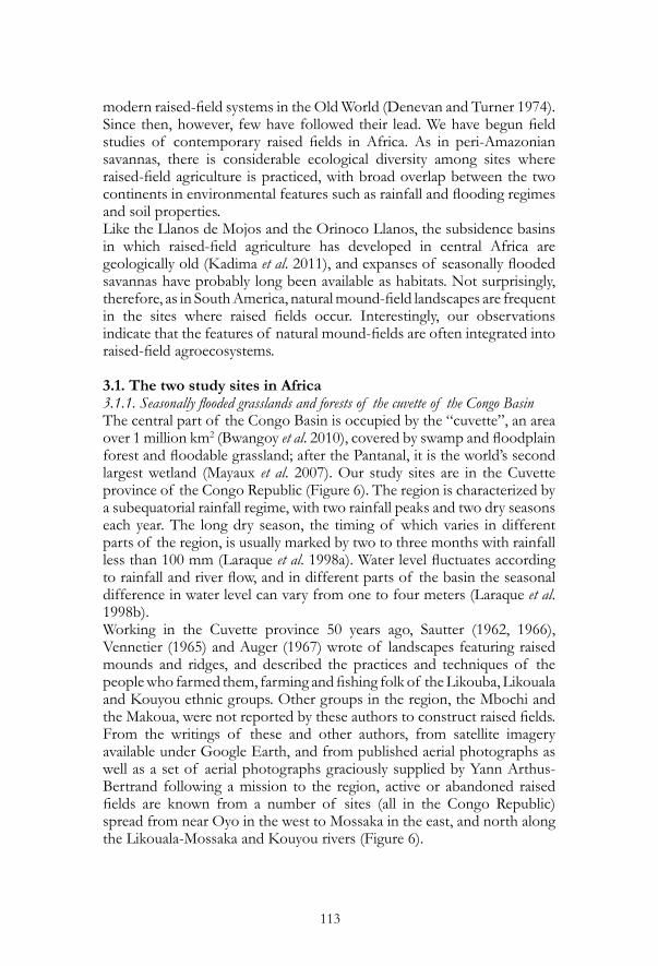
3.1. The two study sites in Africa3.1.1. Seasonally flooded grasslands and forests of the cuvette of the Congo BasinThe central part of the Congo Basin is occupied by the “cuvette”, an area over 1 million km2 (Bwangoy et al. 2010), covered by swamp and floodplain forest and floodable grassland; after the Pantanal, it is the world’s second largest wetland (Mayaux et al. 2007). Our study sites are in the Cuvette province of the Congo Republic (Figure 6). The region is characterized by a subequatorial rainfall regime, with two rainfall peaks and two dry seasons each year. The long dry season, the timing of which varies in different parts of the region, is usually marked by two to three months with rainfall less than 100 mm (Laraque et al. 1998a). Water level fluctuates according to rainfall and river flow, and in different parts of the basin the seasonal difference in water level can vary from one to four meters (Laraque et al. 1998b). Working in the Cuvette province 50 years ago, Sautter (1962, 1966), Vennetier (1965) and Auger (1967) wrote of landscapes featuring raised mounds and ridges, and described the practices and techniques of the people who farmed them, farming and fishing folk of the Likouba, Likouala and Kouyou ethnic groups. Other groups in the region, the Mbochi and the Makoua, were not reported by these authors to construct raised fields. From the writings of these and other authors, from satellite imagery available under Google Earth, and from published aerial photographs as well as a set of aerial photographs graciously supplied by Yann Arthus-Bertrand following a mission to the region, active or abandoned raised fields are known from a number of sites (all in the Congo Republic) spread from near Oyo in the west to Mossaka in the east, and north along the Likouala-Mossaka and Kouyou rivers (Figure 6).
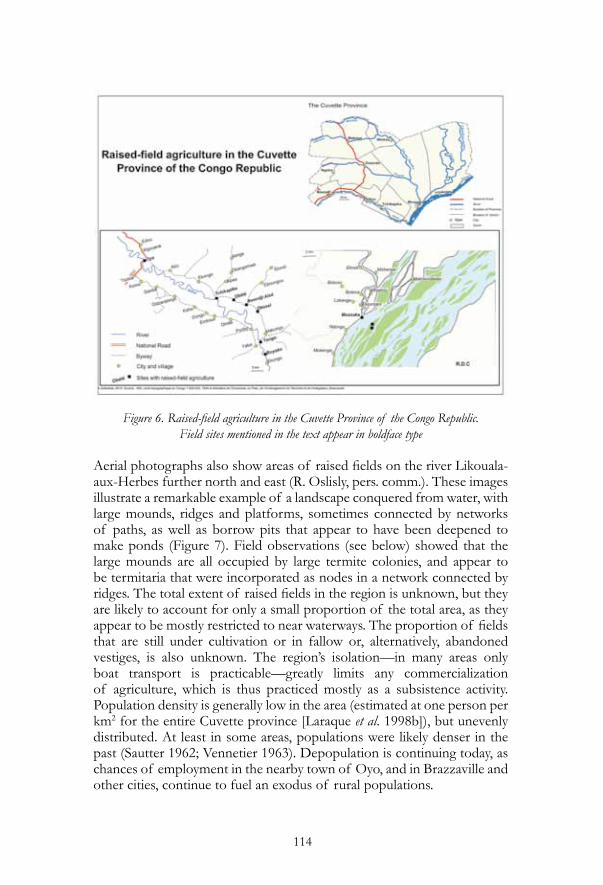
114
Figure 6. Raised-field agriculture in the Cuvette Province of the Congo Republic.Field sites mentioned in the text appear in boldface type
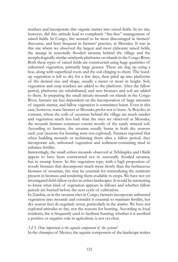
Aerial photographs also show areas of raised fields on the river Likouala-aux-Herbes further north and east (R. Oslisly, pers. comm.). These images illustrate a remarkable example of a landscape conquered from water, with large mounds, ridges and platforms, sometimes connected by networks of paths, as well as borrow pits that appear to have been deepened to make ponds (Figure 7). Field observations (see below) showed that the large mounds are all occupied by large termite colonies, and appear to be termitaria that were incorporated as nodes in a network connected by ridges. The total extent of raised fields in the region is unknown, but they are likely to account for only a small proportion of the total area, as they appear to be mostly restricted to near waterways. The proportion of fields that are still under cultivation or in fallow or, alternatively, abandoned vestiges, is also unknown. The region’s isolation—in many areas only boat transport is practicable—greatly limits any commercialization of agriculture, which is thus practiced mostly as a subsistence activity. Population density is generally low in the area (estimated at one person per km2 for the entire Cuvette province [Laraque et al. 1998b]), but unevenly distributed. At least in some areas, populations were likely denser in the past (Sautter 1962; Vennetier 1963). Depopulation is continuing today, as chances of employment in the nearby town of Oyo, and in Brazzaville and other cities, continue to fuel an exodus of rural populations.

115
Figure 7. Aerial views of raised-field landscapes near Oyo, in the Cuvette region of the Congo Republic. Many of the large mounds appear to be termite mounds, modified by humans.
The images also show linear ridges (paths?) between mounds, and ponds (darker areas) that may be derived from borrow pits. A. Image available through Google Earth V7.1.2.2041;
1° 2’21.39”S, 15°54’6.49”E; January 22, 2006; © 2014 DigitalGlobe; B, C: Aerial photographs taken during a mission by Yann Arthus-Bertrand.
© 2011 Yann Arthus-Bertrand / Altitude-Paris, used by permission.
In January-April 2013 we visited parts of this area, from Oyo and points downstream along the Alima River to Mossaka on the Congo River. Over a distance of 200 km along these rivers, we observed strongly contrasting situations, from landscapes near Oyo abandoned for an unknown number of years to landscapes near Mossaka where area under cultivation is expanding, and where raised-field agriculture is associated with flood recession agriculture on islands in the Congo River. Present-day dynamics seem tied to population shifts (for example, a rural exodus most pronounced near the growing town of Oyo) and changes in practices, but

116
also to variation in subsistence strategies. Raised-field agriculture (Figure 8) is part of a production system comprising several complementary activities, conducted in different parts of the landscape, and its importance differs among villages. A detailed study integrating historical, demographic and ethnoecological data will be required to understand why raised-field agriculture has been abandoned in some areas and persists in others.
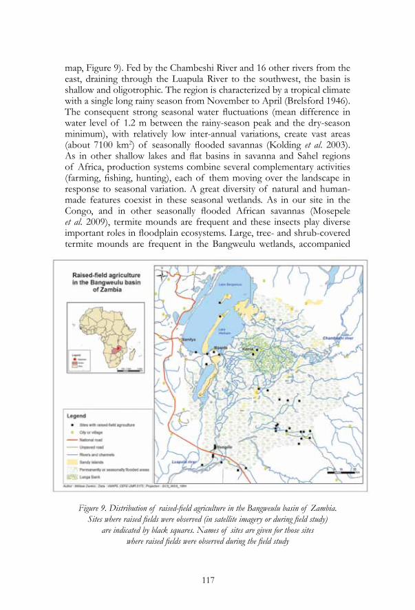
3.1.2. The Bangweulu wetlands in ZambiSurrounded by vast expanses of the miombo woodlands that cover much of southeastern Africa, the Bangweulu basin occupies almost a million hectares of lake, permanent Papyrus marsh and seasonal wetlands (see
Figure 8. Raised fields in the Cuvette Province of the Congo Republic. A. Small round atshoro mounds, Obélé. B: Long ridge raised field, Tchikapika. C: Raised fields (maanga) in flood-prone savanna near Mossaka, showing a fishnet found in the seasonally flooded basin.
D: A mindzenke raised platform, planted with manioc, on an island in the Congo River near Mossaka. This mindzenke was in its second year of use.
Mounds in all photos are approximately 1 m high. Photos © 2013 Doyle McKey
117
map, Figure 9). Fed by the Chambeshi River and 16 other rivers from theeast, draining through the Luapula River to the southwest, the basin is shallow and oligotrophic. The region is characterized by a tropical climate with a single long rainy season from November to April (Brelsford 1946). The consequent strong seasonal water fluctuations (mean difference in water level of 1.2 m between the rainy-season peak and the dry-season minimum), with relatively low inter-annual variations, create vast areas (about 7100 km2) of seasonally flooded savannas (Kolding et al. 2003). As in other shallow lakes and flat basins in savanna and Sahel regions of Africa, production systems combine several complementary activities (farming, fishing, hunting), each of them moving over the landscape in response to seasonal variation. A great diversity of natural and human-made features coexist in these seasonal wetlands. As in our site in the Congo, and in other seasonally flooded African savannas (Mosepele et al. 2009), termite mounds are frequent and these insects play diverseimportant roles in floodplain ecosystems. Large, tree- and shrub-covered termite mounds are frequent in the Bangweulu wetlands, accompanied
Figure 9. Distribution of raised-field agriculture in the Bangweulu basin of Zambia.Sites where raised fields were observed (in satellite imagery or during field study)
are indicated by black squares. Names of sites are given for those sites where raised fields were observed during the field study

118
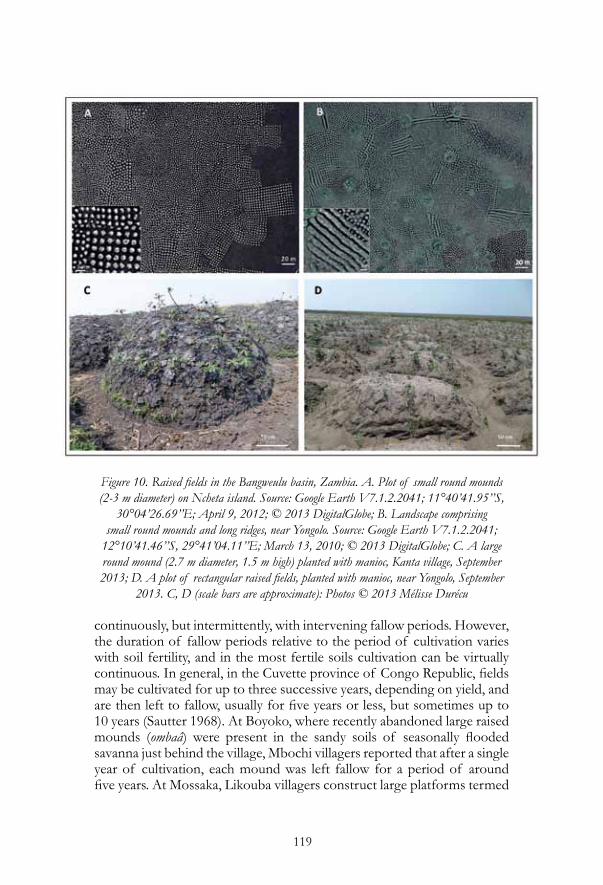
by even more frequent smaller and lower termite mounds. These latter structures appear similar to those observed by Soyer (1983) in seasonally flooded savannas 200 km to the west in the Democratic Republic of the Congo. The most striking human-made features in the flooded Bangweulu wetlands are large numbers of raised fields. These vary in shape, from round mounds (usually about 1.5-2 m in diameter) to ridges that vary in length from 4 to 20 m (exceptionally 40 m) (Figure 10). Parcels of fields also vary in organization, from groups of round mounds in a more or less square grid, to ridges in parallel or in checkerboard patterns (Figure 10B). After extensive preliminary bibliographical research and work with satellite imagery of the region available on Google Earth, we conducted a four-day mission in the Bangweulu wetlands in September 2013, visiting the fields cultivated by people of the Unga ethnic group, whose principal activities are fishing and farming in these wetlands. We observed raised fields (round mounds and short ridges, up to 1 m tall) in seasonally flooded savannas (termed dambos) in two sites near the western and southwestern rim of the basin, Mpanta and Yongolo. A third site, Kanta, is located on Lunga Bank, in the central part of the basin’s vast papyrus marshes (see map, Figure 9). In this lower-lying area, farmers construct raised fields (round mounds) up to 1.6 m in height. In all sites we visited, we observed both active raised fields and others that were in fallow or abandoned.
3.2. What can present-day African systems tell us about contentious questions on raised-field agriculture?3.2.1. How much of the raised-field landscape is cultivated at a given point in time? This question is at the heart of contrasting contentions about how productive pre-Columbian raised-field systems were and how many people they could have supported (Erickson 1992b; Lombardo et al. 2011). Chinampas platforms are cultivated continuously, a situation permitted, in large part, by the recycling of nutrients accumulated in sediments in the flooded basin. When canals between the platforms are periodically cleaned, the sediments are added to the platforms (Armillas 1971). Archaeologists have sometimes assumed that South American raised fields were also continuously cultivated (Erickson and Candler 1989; Kolata 1991). Geoarchaeological data are silent on this point, because they lack the temporal resolution necessary to distinguish continuous cultivation from alternative hypotheses, such as periodic fallows (Bandy 2005; Renard et al. 2012b), crop rotation (Bandy 2005) or the cultivation of only restricted portions of landscape at a given period as hydrological conditions varied over time (e.g., the “shifting-lakeshore model” [Baveye 2013]). In modern African raised-field agroecosystems, are fields cultivated continuously, or are there fallow periods? Our first observations provide insight into this contentious question. In both Congo and Zambia, raised fields are usually not cultivated
119
Figure 10. Raised fields in the Bangweulu basin, Zambia. A. Plot of small round mounds (2-3 m diameter) on Ncheta island. Source: Google Earth V7.1.2.2041; 11°40’41.95’’S,
30°04’26.69’’E; April 9, 2012; © 2013 DigitalGlobe; B. Landscape comprising small round mounds and long ridges, near Yongolo. Source: Google Earth V7.1.2.2041;
12°10’41.46’’S, 29°41’04.11’’E; March 13, 2010; © 2013 DigitalGlobe; C. A large round mound (2.7 m diameter, 1.5 m high) planted with manioc, Kanta village, September 2013; D. A plot of rectangular raised fields, planted with manioc, near Yongolo, September
2013. C, D (scale bars are approximate): Photos © 2013 Mélisse Durécu
continuously, but intermittently, with intervening fallow periods. However, the duration of fallow periods relative to the period of cultivation varies with soil fertility, and in the most fertile soils cultivation can be virtually continuous. In general, in the Cuvette province of Congo Republic, fields may be cultivated for up to three successive years, depending on yield, and are then left to fallow, usually for five years or less, but sometimes up to 10 years (Sautter 1968). At Boyoko, where recently abandoned large raised mounds (ombaâ) were present in the sandy soils of seasonally flooded savanna just behind the village, Mbochi villagers reported that after a single year of cultivation, each mound was left fallow for a period of around five years. At Mossaka, Likouba villagers construct large platforms termed

120
maanga, in seasonally flooded savanna near the village. The mounds are over 1 meter tall and vary from round (4-5 meters in diameter) to oblong (up to 20 meters long). The mounds we observed in Mossaka were on loamy soils, richer than the sandy soils of Boyoko. Villagers in Mossaka reported that each mound is cultivated for two to three years and then left in fallow for only one-two years. However, poor sandy soils also occur in Mossaka and fallow periods on these soils are longer than the periods of cultivation (Sautter 1962). Farmers at Mossaka also farm the very fertile soil of islands in the Congo River, growing manioc and a few other crops over the six-month period that the island fields are above flood level. The island fields are mostly small, hoed-up mounds (mitsaba), but scattered among these are also large raised platforms (mindzenke), constructed in a manner similar to the maanga. Those we saw were over one meter tall, about two meters broad and 20 meters long. According to the villagers, crops planted on the platforms benefit from about two weeks’ additional time until flooding forces their harvest. In the rich soils of the islands, fields (both mitsaba and mindzenke) are often cultivated many years successively. However, even there, some farmers prefer to leave fields fallow for two to three years after five years of cultivation. Management of raised fields in the Bangweulu wetlands also usually features intermittent fallow periods. In this region as well, the duration of fallows relative to periods of cultivation varies with soil fertility. In two sites we visited, Mpanta and Yongolo, villagers construct raised fields in the dambos. The soils of these seasonally flooded savannas on the western and southwestern rim of the basin are sandy and infertile. In these sites, farmers reported that fields were usually cultivated for one to two years, then left in fallow, usually for periods of one to three years. In contrast, at Kanta on Lunga Bank in the center of the basin, where soils are loamy and organic matter-rich, farmers reported that they cultivate fields every year, with no intervening fallow other than the six-month period when the fields are entirely flooded. To summarize, except in the most fertile soils, fallow periods appear to be essential for sustainable production in both Congo and Zambia. Another criticism of archaeologists’ estimates of the size of human populations that could have been supported by pre-Columbian raised fields is embodied by what Baveye (2013) has termed the “shifting-lakeshore” hypothesis: because hydrological conditions in a basin varied over time, at any given time only a small portion of the modified landscape may have been under cultivation. Because most authors have not taken such fluctuation into account, they have produced, according to this hypothesis, inflated estimates of area under cultivation and population density. Our observations cast a different light on this hypothesis. At sites in the Congo, we did in fact find that hydrological conditions varied greatly among sites occupied by raised fields (active or inactive). However, in contrast

121
to an implicit assumption of the shifting-lakeshore model, cultivation was not limited to a restricted set of hydrological conditions. Instead, farmers exploited gradients of elevation and drainage to plant a diversity of crops, ranging from manioc and sweet potatoes in the most humid sites to dryland crops such as Bambara groundnut (Vigna subterranea) in raised fields on the driest, sandiest savannas we observed (for example, at Boyoko). Furthermore, at one site, Obélé, we observed a single farm that covered a drainage gradient from raised mounds surrounded by thigh-deep water up to smaller mounds that were never flooded, even during the peak of the rains. The farmer used this gradient to extend the field’s period of production, notably staggering the planting (and harvesting) of maize over a period of several months from the bottom to the top of the drainage gradient.Observations in both African sites underline our contention (see section 1.2) that raised-field agriculture can only be understood in the context of the complex subsistence systems of which it constitutes a part. As in other tropical wetlands characterized by flat basins (e.g., Lake Chad [Raymond et al. 2014]), hydrological conditions vary greatly from place to place and over the annual cycle. As a function of this heterogeneity, subsistence activities are diverse and often highly mobile. Even when we consider only one kind of subsistence activity, agriculture, “raised-field farmers” also conduct various types of flood-recession agriculture; and the same people farm not only in wetlands but also conduct other kinds of agriculture in the uplands. For example, at Yongolo in Zambia, some individual farmers cultivated not only raised fields in the dambos but also slash-and-burn fields in miombo woodlands 40 km distant. In addition to considering raised-field farming as only one of many subsistence activities, analysis of these systems must also take into account the challenges identified for agriculture in sub-Saharan Africa in a context of demographic growth (Losch et al. 2013; Morris et al. 2009).
3.2.2. How are fallows managed? On the basis of geoarchaeological data—the much lower abundance of charcoal in sediments during the period of raised-field cultivation than after raised fields were abandoned—Iriarte et al. (2012) postulated that raised-field farmers in the coastal savannas of French Guiana suppressed fire, practicing a “slash-and-mulch” management of fallows that favored the maintenance of vegetation and its incorporation into soil organic matter that would sustain the next cycle of cultivation. How are fallows managed in modern African raised-field systems? Is burning (of fallow vegetation, of crop residues) frequently employed, or is organic matter incorporated into soil organic matter?In both Congo and Zambia, farmers we interviewed considered it important to conserve the biomass from fallow vegetation and crop
122
residues and incorporate this organic matter into raised fields. In no site, however, did this attitude lead to completely “fire-free” management of raised fields. In Congo, fire seemed to be most discouraged in farmers’ discourse, and least frequent in farmers’ practice, at Mossaka. It was in this site where we observed the largest and most elaborate raised fields, the maanga in seasonally flooded savanna behind the village and the morphologically similar mindzenke platforms on islands in the Congo River. Both these types of raised fields are constructed using huge quantities of unburned vegetation, primarily large grasses. These are dug up using a hoe, along with superficial roots and the soil clinging to them. The hoed-up vegetation is left to dry for a few days, then piled up into platforms of the desired size and shape, usually a meter or more in height. Soil, vegetation and crop residues are added to the platform. After the fallow period, platforms are rehabilitated, and new biomass and soil are added to them. In preparing the small mitsaba mounds on islands in the Congo River, farmers are less dependent on the incorporation of large amounts of organic matter, and fallow vegetation is sometimes burnt. Even in this case, however, some farmers at Mossaka prefer not to burn. At Boyoko, in contrast, where the soils of savannas behind the village are much sandier and vegetation much less lush than the sites we observed at Mossaka, the mounds farmers construct consist mostly of the sandy mineral soil. According to farmers, the savanna usually burns in both dry seasons each year (reasons for burning were not explored). Farmers reported that when building mounds or reclaiming them after a fallow period, they incorporate ash, unburned vegetation and sediment-containing mud to enhance fertility.Interestingly, the small atshoro mounds observed at Tchikapika and Obélé appear to have been constructed not in seasonally flooded savanna, but in swamp forest. In this vegetation type, with a high proportion of woody biomass that decomposes much more slowly than the herbaceous biomass of savannas, fire may be essential for mineralizing the nutrients present in biomass and rendering them available to crops. We have not yet investigated field-fallow cycles in atshoro landscapes. It would be interesting to know what kind of vegetation appears in fallows and whether fallow parcels are burned before the next cycle of cultivation.In Zambia, as in the savanna sites in Congo, farmers incorporate unburned vegetation into mounds and consider it essential to maintain fertility, but dry-season fires do regularly occur, particularly in the dambos. We have not explored attitudes to fire, nor the reasons for burning. According to local residents, fire is frequently used to facilitate hunting; whether it is ascribed a positive or negative role in agriculture is not yet clear.
3.2.3. How important is the aquatic component of the system?In the chinampas of Mexico, the aquatic component of the landscape makes

123
several key contributions to agriculture and to other subsistence activities. Water in canals permits bucket irrigation of the raised platforms during dry periods. Sediments eroded from the platforms, or from elsewhere in the watershed, are trapped in the muck of canals and recycled back onto the platforms. Aquatic macrophytes further contribute to organic matter production. Water lilies, water hyacinth, and other tender non-graminoid aquatic herbs produce organic matter with higher quality for decomposers (e.g., lower C/N ratios) than that of tough grasses and sedges. Finally, fish are harvested from the canals. Some authors have postulated that the aquatic component played similar roles in pre-Columbian raised-field systems in South America (Erickson 1995, 1999; Kolata and Ortloff 1989). For example, Erickson (2000) built a convincing case that zigzag lines in seasonally flooded savannas of the Llanos de Mojos, often somewhat distant from complexes of raised fields in the same landscapes, are the vestiges of fish weirs that supported an extensive fishery, contributing to the protein supply of the raised-field farmers. Biesboer et al. (1999) found that in experimentally reconstructed raised fields and canals around Lake Titicaca, aquatic vegetation included plants with symbiotic associations with nitrogen-fixing microorganisms, contributing to the stocks of this important nutrient in raised-field ecosystems. In experimentally reconstructed raised fields in the Llanos de Mojos, tender aquatic macrophytes such as Eichhornia (water hyacinth) are abundant (Barba et al. 2003; Saavedra 2009), and use of organic matter derived from them as mulch could have contributed to nutrient recycling within the system. Other authors, however, believe that these demonstrated benefits of the aquatic component of the chinampas have been over-estimated in other raised-field systems (Baveye 2013; Chapin 1988; Lombardo et al. 2011). In both Congo and Zambia, resources from the aquatic component are of primordial importance in the functioning of subsistence systems. In both sites, vegetation in the seasonally flooded basin supplies organic matter that is used in mound construction. In most areas in these sites, however, the basin is probably dry for too long a part of each year for tender aquatic macrophytes to be abundant and play any substantial role in nutrient supply to raised fields. The biomass and organic matter added to mounds is primarily from graminoids. However, in some of the Congo sites (e.g., atshoro mounds in swamp forest at Tchikapika and Obélé), tender aquatic plants are abundant, and their organic matter is regularly moved from the flooded basin onto the raised fields. To summarize, organic mulch is everywhere regarded as important, but the role of aquatic vegetation as a source varies with flooding regime, and is probably rarely as important as in the chinampas system. In both Congo and Zambia, fish are an important food resource supplied by the raised-field landscape, and “agricultural mounds” are often intentionally constructed to serve also as fish-trapping devices (Sautter
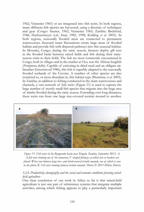
124
1962; Vennetier 1965) or are integrated into fish weirs. In both regions, many different fish species are harvested, using a diversity of techniques and gear (Congo: Sautter, 1962; Vennetier 1965; Zambia: Brelsford, 1946; Huchzermeyer n.d.; Imai, 1985, 1998; Kolding et al. 2003). In both regions, seasonally flooded areas are connected to permanent watercourses. Seasonal water fluctuations create large areas of flooded habitat and provide fish with dispersal pathways into this seasonal habitat. In Mossaka, Congo, during the rainy season, farmers deploy gill nets in the flooded basin between raised fields and fish during their rainy-season visits to their fields. The fish we most commonly encountered in Congo, both in villages and in the market at Oyo, was the African lungfish (Protopterus dolloi). Capable of estivating in dried mud and an obligate air-breather (Greenwood 1986), this fish is superbly adapted to the seasonally flooded wetlands of the Cuvette. A number of other species are also restricted to, or most abundant in, this habitat type (Shumway et al. 2003). In Zambia, in addition to fishing conducted in the main watercourses and channels, a vast network of fish weirs (Figure 11) is used to capture the large number of mostly small fish species that migrate into the huge area of dambos flooded during the rainy season. Extending over long distances, these weirs run from one large tree-covered termite mound to another.
Figure 11. Fish weirs in the Bangweulu basin near Yongolo, Zambia, September 2013. A. A fish weir showing one of the numerous V-shaped fishways at which nets or baskets are
placed. Weirs run between large tree- and shrub-covered termite mounds, one of which is seen in the photo; B. Fish weir running between termite mounds. Photos © 2013 Mélisse Durécu
3.2.4. Productivity, demography and the social and economic conditions favoring raised-field agricultureOne clear conclusion of our work in Africa so far is that raised-field agriculture is just one part of subsistence systems that integrate multiple activities, among which fishing appears to play a particularly important

125
role. Erickson (2000) has presented evidence that this was also true in pre-Columbian systems in the Llanos de Mojos. Although many other authors on pre-Columbian raised-field agriculture mention the likely importance of fish, this resource has usually not been taken into account in estimates of productivity, which focus on products of agriculture. Our observations of contemporary African systems show that failure to account for this crucial protein source in estimates of productivity and carrying capacity would be a serious error. The vestiges of pre-Columbian fish weirs found by Erickson (2000) in the Llanos de Mojos, Bolivia—comparable in their morphology and likely functioning to those that are widespread in the Bangweulu floodplains—support the contention that pre-Columbian systems were similarly reliant on fish. In this respect the chinampas appear not to be unique.Detailed study of these contemporary African systems could provide many other insights into raised-field agriculture, not only its past in South America, but its potential contributions to sustainable use of seasonal tropical wetlands today and in the future. How much labor is required to build and maintain raised fields? How is this work organized socially, and how do economic conditions (for example, complementarity of other activities, markets for agricultural production, rural exodus to cities, etc.) affect the maintenance or the decline of raised-field agriculture? Having answers to these questions would help us assess whether raised-field agriculture has developed out of necessity, as easier ways to subsist become impossible owing to population pressure (Boserup 1965), or whether multi-activity subsistence systems incorporating this kind of agriculture are adopted because of advantages they confer, such as risk reduction.
4. Conclusion
As in the neotropics (Renard et al. 2012b), the biophysical and cultural contexts in which raised-field agriculture is found in Africa show great diversity. Hasty overgeneralizations must be avoided. However, several conclusions appear to be justified. First, in both African sites, landscapes and subsistence systems have emerged from the coevolutionary interplay of ecological dynamics and social practices. In both sites, self-organized structures of natural origin are incorporated into biocultural landscapes. In Zambia, termite-mound islands in the dambos and floodplains are the most favored sites for constructing fields, as they are already elevated and well-drained, and are islands of fertility. Termite-mound islands also constitute the nodes of the extensive networks of fish weirs in the dambos. Similarly, in the abandoned agricultural landscapes near Oyo, Congo, large termite mounds termed ingondo, usually around 6 m in diameter, appear to have been integrated into a network of human-made structures, including more or less

126
rectilinear paths between the mounds, linear or curvilinear raised ridges, and borrow pits deepened into ponds. Thus, as in South America, natural soil engineers appear to be an integral part of the origin and functioning of raised-field landscapes. The biology of soil engineers in the African landscapes, and whether they play important roles in maintaining fertility of active fields or the ecological legacy of abandoned fields, are subjects for future enquiry. Whether people are aware of their interactions with soil engineers, and whether human-constructed parts of the landscape correspond to a deliberate social project or emerge from a succession of individual projects realized over a long period of time, are also open questions. Like the biological components, the cultural parts of these biocultural landscapes may also result from self-organized processes, albeit by quite different mechanisms. As part of the interplay of ecological dynamics and social practices, human-made structures may, as in South America, feed back on ecological processes, creating an ecological legacy of human actions. Feedbacks may sometimes occur in unexpected ways. For example, by retaining water for varying periods, fish weirs in floodplains of the Bangweulu Basin may affect the hydrology of different parts of the basin, and thereby vegetation and the animals that depend on it. However, their most conspicuous impact may be their action as dry-season firebreaks, contributing to the mosaic nature of fire in the basin (C. Huchzermeyer, South African Institute of Aquatic Biodiversity, pers. comm.). The complex interplay of ecological dynamics and social practices suggests that understanding the functioning of contemporary systems in African wetlands will require input from the same broad range of disciplines as was brought to bear to understand the history and ecology of raised-field landscapes in South America (Iriarte et al. 2012; McKey et al. 2010; Renard et al. 2013).Second, as we have emphasized at several points in this chapter, raised-field agriculture in both African sites is only one part of a multi-functional subsistence system, and cannot be understood outside this more inclusive context. Fish appear to play a particularly important role in the system. As in rice-fish co-culture systems in tropical Asia (Xie et al. 2011), fish and crops may interact in multiple and intriguing ways. Only when we take into account the ecological, cultural and economic aspects of all parts of the system can we address the role of raised-field agriculture in a hoped-for sustainable future. The two present-day examples we have begun to document suggest that this role may be far from negligible.
Acknowledgments
The first author of this paper would like to thank Stéphen Rostain and the organizing committee for the invitation to present a plenary talk at the EIAA symposium in Quito in September 2013 and for financial support
127
to attend the meeting. The fieldwork behind this chapter was supported by two interdisciplinary programs of the Institut d’Ecologie et Environnement (INEE, CNRS), “Amazonie” and “Ingénierie Ecologique” (French Guiana); by the Institut Universitaire de France (Colombia, Congo) and by the GDR Mosaïque (INEE, CNRS), coordinated by Yildiz-Aumeeruddy-Thomas (Zambia). Work in Colombia was supported by a grant from the program ECOS/COLCIENCIAS to Anne Zangerlé.We also thank Yann Arthus-Bertrand and his team for permission to use their magnificient aerial photographs of raised-field landscapes in the Cuvette Province of the Congo Republic. Finally, Eric Garine (Université Paris 10-Nanterre) critically read the entire manuscript and helped us tighten the text.
References
Armillas, P. 1971. Gardens on swamps. Archaeological research verifies historical data on Aztec land reclamation in the valley of Mexico. Science 174: 653-661.
Auger, A. 1967. Loboko : exemple de terrain conquis sur l’eau. Photo Interprétation 67: 22-28.
Baker, J.L. 2003. Maya Wetlands. Ecology and Pre-Hispanic Utilization of Wetlands in Northwestern Belize. PhD dissertation, University of Arizona, Tucson, AZ. http://arizona.openrepository.com/arizona/bitstream/10150/237812/3/azu_td_3089896_sip1_m.pdf
Balée, W. L. and C. L. Erickson. 2006. Time and Complexity in Historical Ecology: Studies in the Neotropical Lowlands. Columbia University Press, New York.
Bandy, M. S. 2005. Energetic efficiency and political expediency in Titicaca Basin raised field agriculture. Journal of Anthropological Archaeology 24: 271-296.
Barba, J., E. Canal, E. Garcia, E. Jorda, M. Miro, E. Pasto, R. Playa, I. Romero, M. Via and E. Woynarovich. 2003. Moxos: Una Limnocultura. Cultura y Medio Ambiente en la Amazonia Boliviana. CEAM, Barcelona.
Barlow, J., T. A. Gardner, A. C. Lees, L. Parry and C. A. Peres. 2012. How pristine are tropical forests? An ecological perspective on the pre-Columbian human footprint in Amazonia and implications for contemporary conservation. Biological Conservation 151: 45-49.
Bates, M. 1948. Climate and vegetation in the Villavicencio region of eastern Colombia. Geographical Review 38: 555-574.
Baveye, P. C. 2013. Comment on “Ecological engineers ahead of their time: The functioning of pre-Columbian raised-field agriculture and its potential contributions to sustainability today” by Dephine

128
Renard et al. Ecological Engineering 52. http://dx.doi.org/10.1016/j.ecoleng.2012.11.011.
Beard J. S. 1953. The savanna vegetation of northern tropical America. Ecological Monographs 23: 149-215.
Biesboer, D. D., M. Binford and A. Kolata. 1999. Nitrogen fixation in soils and canals of rehabilitated raised-fields of the Bolivian Altiplano. Biotropica 31: 255-267.
Birk, J. J., W. G. Teixeira, E. G. Neves and B. Glaser. 2011. Faeces deposition on Amazonian Anthrosols as assessed from 5b-stanols. Journal of Archaeological Science 38: 1209-1220.
Boserup, E. 1965. The Conditions of Agricultural Growth: The Economics of Agrarian Change Under Population Pressure. Transaction Publishers, New Brunswick, NJ.
Brelsford, W. V. 1946. Fishermen of the Bangweulu Swamps: a Study of the Fishing Activities of the Unga Tribe. Rhodes-Livingstone Institute, Lusaka, Zambia.
Bruno, M. C. 2014. Beyond raised fields: exploring farming practices and processes of agricultural change in the ancient Lake Titicaca Basin of the Andes. American Anthropologist 116: 1-16.
Bush, M. B. and M. R. Silman. 2007. Amazonian exploitation revisited: ecological asymmetry and the policy pendulum. Frontiers in Ecology and the Environment 5: 457-465.
Bwangoy, J. R. B., M. C. Hansen, D. P. Roy, G. D. Grandi and C. O. Justice. 2010. Wetland mapping in the Congo Basin using optical and radar remotely sensed data and derived topographical indices. Remote Sensing of Environment 114: 73-86.
Carneiro, R. 1960. Slash-and-burn agriculture: a closer look at its implications for settlement patterns. Men and Cultures, A. Wallace (Editor), University of Pennsylvania Press, Philadelphia, PA: 229-234.
Carneiro, R. L. and C. Kramer. 1979. Tree felling with the stone axe: An experiment carried out among the Yanomamo Indians of Southern Venezuela. Ethnoarchaeology: Implications of Ethnography for Archaeology, C. Kramer (Editor), Columbia University Press, New York: 21-58.
Chacón-Moreno E. J, M. E. Naranjo and D. Acevedo. 2004. Direct and indirect vegetation-environment relationships in the flooding savanna of Venezuela. Ecotropicos 17: 25-37.
Chapin, M. 1988. The seduction of models: Chinampa agriculture in Mexico. Grassroots Development 12: 8-17.
Clement, C. R. and A. B. Junqueira. 2010. Between a pristine myth and an impoverished future. Biotropica 42: 534-536.
Colinvaux, P. A. 1989. The past and future Amazon. Scientific American 260: 102-108.
De Las Casas, B. 1986 [1560]. Historia de las Indias. Biblioteca Ayacucho,

129
Caracas, Venezuela.Denevan, W. M. 1966. The Aboriginal Cultural Geography of the Llanos de Mojos
of Bolivia. No. 24, National Academy of Sciences National Research Council, Foreign Field Research Progamm. Washington, D.C.
Denevan, W. M. 1982. Hydraulic agriculture in the American tropics: forms, measures, and recent research. Maya Subsistence, K. V. Flannery (Editor), Academic Press, New York: 181-203.
Denevan, W. M. (Editor) 1992. The Native Population of the Americas in 1492. Second Edition. University of Wisconsin Press, Madison, WI.
Denevan, W. M. 1995. Prehistorical agricultural methods as models for sustainability. Advances in Plant Pathology 11: 21-43.
Denevan, W. M. 2001. Cultivated Landscapes of Native Amazonia and the Andes, Oxford University Press, Oxford.
Denevan, W. M. and B. L. Turner. 1974. Forms, functions and associations of raised fields in the Old World tropics. Journal of Tropical Geography 39: 24-33.
Doolittle, W. E. 2000. Cultivated Landscapes of Native North America. Oxford University Press, Oxford.
Edwards C. A. and P. J. Bohlen. 1972. Biology and Ecology of Earthworms. 3rd Edition. Chapman and Hall, London.
Erickson C. L. 1987. The dating of raised field agriculture in the Lake Titicaca Basin of Peru. Pre-hispanic Agricultural Fields in the Andean Region, W. M. Denevan, K. Mathewson and G. Knapp (Editors). British Archaeological Reports, International Series 359, Oxford: 373-383.
Erickson, C. L. 1992a. Applied archaeology and rural development: archaeology’s potential contribution to development. Journal of the Steward Anthropological Society 20: 1-16.
Erickson, C. L. 1992b. Prehistoric landscape management in the Andean highlands: raised field agriculture and its environmental impact. Population and Environment (Special issue “Social Science Perspectives on Environmental Management,” edited by Timothy Kohler), 13(4): 285-300.
Erickson, C. L. 1994a. Methodological considerations in the study of ancient Andean field systems. The Archaeology of Garden and Field, N. K. Miller and K. L. Gleason (Editors), University of Pennsylvania Press, Philadelphia, PA: 111-152.
Erickson, C.L. 1994b. Raised fields as a sustainable agricultural system from Amazonia. Paper presented in the Symposium Recovery of Indigenous Technology and Resources in Bolivia at the 18th International Congress of the Latin American Studies Association, Atlanta, March 10-12. http://repository.upenn.edu/anthro_papers/14
Erickson, C. L. 1995. Archaeological methods for the study of ancient
130
landscapes of the Llanos de Mojos in the Bolivian Amazon. Archaeology in the Lowland American Tropics, P. Stahl (Editor), Cambridge University Press, Cambridge: 111-152.
Erickson, C. L. 1999. Agricultura en camellones prehispánicos en las tierras bajas de Bolivia: Posibilidades de desarrollo en el trópico húmedo. Los Camellones y Chinampas Tropicales: Memorias del Simposio-Taller Internacional sobre Camellones y Chinampas Tropicales, J. J. Jiménez-Orsornio and V. M. Rorive (Editors), Ediciones de la Universidad Autónomo de Yucatán, Mérida, Mexico: 39-52.
Erickson C. L. 2000. An artificial landscape-scale fishery in the Bolivian Amazon. Nature 408: 190-193.
Erickson, C. L. 2008. Amazonia: the historical ecology of a domesticated landscape. The Handbook of South American Archaeology, H. Silverman and W. H. Isbell (Editors), Springer-Verlag, New York: 157-183.
Erickson C. L. and K. I. Candler. 1989. Raised fields and sustainable agriculture in the Lake Titicaca basin of Peru. Fragile lands of Latin America: Strategies for Sustainable Development., J. O. Browder (Editor), Westview Press, Boulder, CO: 230-248.
Gabet, E. J., J. T. Perron and D. L. Johnson. 2013. Biotic origin for Mima mounds supported by numerical modeling. Geomorphology, in press. http://dx.doi.org/10.1016/j.geomorph.2013.09.018.
Glaser, B. and J. J. Birk. 2012. State of the scientific knowledge on properties and genesis of Anthropogenic Dark Earths in Central Amazonia (Terra Preta de Índio). Geochimica et Cosmochimica Acta 82: 39-51.
Glaser, B. and W. I. Woods (Editors) 2004. Amazonian Dark Earths: Explorations in Space and Time. Springer, Berlin.
Gomez-Pompa, A., H. L. Morales, E. Jimenez Avila and J. Jimenez Avila. 1982. Experiences in traditional hydraulic agriculture. Maya Subsistence: Studies in Memory of Dennis E. Puleston, K. V. Flannery (Editor), Academic Press, New York: 327-342.
Gondard, P., 2006. Campos elevados en llanuras húmedas. Del modelado al paisaje. Camellones, waru warus o pijales. Agricultura Ancestral. Camellones y Albarradas. Contexto Social, Usos y Retos del Pasado y del Presente. F. Valdez (Editor), Ediciones Abya-Yala, Quito: 25-53.
Gondard, P. 2008. Les camellones sud-américains. Agricultures Singulières, E. Mollard and A. Walter (Editors), IRD Editions, Paris: 75-80.
Greenwood, P. H. (1986). The natural history of African lungfishes. Journal of Morphology 190(S1): 163-179.
Gumilla, J. 1963 [1791]. The Orinoco Illustrated and Defended. Biblioteca de la Academia Nacional de Historia, Caracas (translated from Spanish).
Haase, R. and G. Beck. 1989. Structure and composition of savanna vegetation in northern Bolivia: a preliminary report. Brittonia 41: 80-100.

131
Hansen, M. C., et alii. The Forests of the Congo Basin: State of the Forest 2006. carpe. umd. edu/resources/Documents/THE FORESTS OF THE CONGO BASIN State of the Forest (2006).
Heckenberger, M. J., J. B. Petersen and E. G. Neves. 1999. Village size and permanence in Amazonia: two archaeological examples from Brazil. Latin American Antiquity 10: 353-376.
Heckenberger, M. J., J. C. Russell, C. Fausto, J. R. Toney, M. J. Schmidt, E. Pereira, B. Franchetto and A. Kuikuro. 2008. Pre-Columbian urbanism, anthropogenic landscapes, and the future of the Amazon. Science 321: 1214-1217.
Heckenberger, M. J., J. C. Russell, J. R. Toney, and M. J. Schmidt. 2007. The legacy of cultural landscapes in the Brazilian Amazon: implications for biodiversity. Philosophical Transactions of the Royal Society B 362: 197-208.
Hurtado, A. M. and K. Hill. 1989. Experimental studies of tool efficiency among Machiguenga women and implications for root-digging foragers. Journal of Anthropological Research 45: 207-217.
Huchzermeyer C. F. n.d. Fishes and fisheries of the Bangweulu Wetlands and Lavushi Manda National Park. South African Institute for Aquatic Biodiversity, Grahamstown, South Africa. http://bangweulufish.files.wordpress.com/2012/08/bangweulu-wetlands-fishes-and-fisheries-with-additions-and-changes-aug-2012.pdf
Imai, I. 1985. Fishing life in the Bangweulu Swamps: a socio-ecological study of the swamp fishermen in Zambia. African Study Monographs. Supplementary Issue 4: 49-88.
Imai, I. 1998. Sustainability of fishing in the Bangweulu Swamps, Zambia. African Study Monographs 19: 69-86.
Iriarte, J., B. Glaser, J. Watling, A. Wainwright, J. J. Birk, D. Renard, S. Rostain and D. McKey. 2010. Late Holocene Neotropical agricultural landscapes: phytolith and stable carbon isotope analysis of raised fields from French Guianan coastal savannahs. Journal of Archaeological Science 37: 2984-2994.
Iriarte, J., M. J. Power, S. Rostain, F. E. Mayle, H. Jones, J. Watling, B. S. Whitney and D. B. McKey. 2012. Fire-free land use in pre-1492 Amazonian savannas. Proceedings of the National Academy of Sciences, 109: 6473-6478.
Iriondo, M. 2004. Large wetlands of South America: a model for Quaternary humid environments. Quaternary International 114: 3-9.
Jones, C. G., J. H. Lawton and M. Shachak. 1994. Organisms as ecosystem engineers. Oikos 69: 373-386.
Junqueira, A.B., G. H. Shepard Jr. and C. R. Clement. 2010. Secondary forests on anthropogenic soils in Brazilian Amazonia conserve agrobiodiversity. Biodiversity and Conservation 19: 1933-1961.
Kadima, E., D. Delvaux, S. N. Sebagenzi, L. Tack and S. M. Kabeya. 2011.

132
Structure and geological history of the Congo Basin: an integrated interpretation of gravity, magnetic and reflection seismic data. Basin Research 23: 499-527.
Kolata, A.. L. 1991. The technology and organization of agricultural production in the Tiwanaku state. Latin American Antiquity 2: 99-125.
Kolata, A. L. 1993. The Tiwanaku: Portrait of an Andean Civilization. Blackwell, Cambridge.
Kolata, A. L. 1996. Tiwanaku and its Hinterland: Archaeology and Paleoecology of an Andean Civilization. Smithsonian Institution Press, Washington, DC.
Kolata, A. L. and C. Ortloff. 1989. Thermal analysis of Tiwanaku raised field systems in the Lake Titicaca Basin of Bolivia. Journal of Archaeological Science 16: 233-263.
Kolding J., H. Ticheler and B. Chanda. 2003. The Bangweulu Swamps, a balanced small-scale multispecies fishery. In: Management, Comanagement or No Management? Major Dilemmas in Southern African Freshwater Fisheries, 2: Case Studies, FAO Fisheries Technical Paper 426/2, E. Jul-Larsen, J. Kolding, R. Overa, J. R. Nielsen and P. A. M. Zwieten (Editors), Food and Agriculture Organization, Rome: 34-66.
Langstroth, R. P. 1996. Forest islands in an Amazo nian savanna of Northeastern Bolivia. Unpublished Ph.D. dissertation. University of Wisconsin, Department of Geography, Madison, WI.
Langstroth, R. P. 2011. Biogeography of the Llanos de Moxos: Natural and anthropogenic determinants. Geographica Helvetica 66: 183-192.
Laraque, A., M. Mietton, J. C. Olivry and A. Pandic. 1998a. Influence des couvertures lithologiques et végétales sur les régimes et la qualité des eaux des affluents congolais du fleuve Congo. Revue des Sciences de l’Eau/Journal of Water Science 11: 209-224.
Laraque, A., et alii (13 authors). 1998b. Origin and function of a closed depression in equatorial humid zones: the Lake Télé in North Congo. Journal of Hydrology 207: 236-253.
Lehmann, J., D. C. Kern, B. Glaser and W. I. Woods (Editors), 2003. Amazonian Dark Earths: Origin, Properties, Management. Kluwer Academic Publishers, Dordrecht, Netherlands.
Levis, C., P. F. de Souza, J. Schietti, T. Emilio, J. L. P. da Veiga Pinto C. R. Clement and F. R Costa. 2012. Historical human footprint on modern tree species composition in the Purus-Madeira interfluve, central Amazonia. PLOS ONE, 7(11), e48559.
Lombardo, U., E. Canal-Beeby, S. Fehr and H. Veit. 2011. Raised fields in the Bolivian Amazonia: a prehistoric green revolution or a flood risk mitigation strategy? Journal of Archaeological Science 38: 502-512.
Lombardo U, Szabo K, Capriles JM, May J-H, Amelung W, et alii. 2013.

133
Early and middle Holocene hunter-gatherer occupations in western Amazonia: the hidden shell middens. PLoS ONE 8(8): e72746. doi:10.1371/journal.pone.0072746
Losch B., G. Magrin and J. Imbernon (dir.), 2013. New Emerging Rural World. An Overview of Rural Change in Africa. Atlas for NEPAD Rural FuturespProgram, Montpellier, CIRAD, 46 p. http://www.nepad.org/crosscuttingissues/knowledge/doc/3105/new-emerging-rural-world
Maina, J. N., G. O. Maloiy and C. M. Wood. 1998. Respiratory stratagems, mechanisms, and morphology of the ‘lung’ of a tropical swamp worm, Alma emini Mich. (Oligochaeta: Glossoscolecidae): a transmission and scanning electron microscope study, with field and laboratory observations. Journal of Zoology 245: 483-495.
Mayaux, P., P. Defourny, D. Devers, M, Hansen and G. Duveiller. 2007. The Forests of the Congo Basin: State of the Forests, 2006. Document prepared for the Congo Basin Forest Partnership available online at http://www. cbfp. org/congobasin. html.
Mayle, F. E., R. P. Langstroth, R. A. Fisher and P. Meir. 2007. Long-term forest–savannah dynamics in the Bolivian Amazon: implications for conservation. Philosophical Transactions of the Royal Society B: Biological Sciences 362: 291-307.
McKey, D., S. Rostain, J. Iriarte, B. Glaser, J. J. Birk, I. Holst and D. Renard. 2010. Pre-Columbian agricultural landscapes, ecosystem engineers, and self-organized patchiness in Amazonia. Proceedings of the National Academy of Sciences 107: 7823-7828.
McMichael, C. H., D. R. Piperno, M. B. Bush, M. R. Silman, A. R. Zimmerman, M. F. Raczka and L.C. Lobato. 2012. Sparse pre-Columbian human habitation in Western Amazonia. Science 336: 1429-1431.
Meggers, B J. 2003. Natural versus anthropogenic sources of Amazonian biodiversity: the continuing quest for El Dorado. How Landscapes Change, G. A. Bradshaw and P..A. Marquet (Editors), Springer-Verlag, Berlin and Heidelberg: 89-107.
Merlín-Uribe, Y., C. E. González-Esquivel, A. Contreras-Hernández, L. Zambrano, P. Moreno-Casasola and M. Astier, M. 2012. Environmental and socio-economic sustainability of chinampas (raised beds) in Xochimilco, Mexico City. International Journal of Agricultural Sustainability 11: 216-233.
Meron, E. 2012. Pattern-formation approach to modelling spatially extended ecosystems. Ecological Modelling 234: 70-82.
Morris, A. S. 2004. Raised Field Technology: the Raised Fields Projects Around Lake Titicaca. King’s SOAS Studies in Development Geography. Ashgate Publishing Limited, Aldershot.
Morris, M., H. Binswanger, D. Byerlee, P. Savanti and J. Staatz. 2009.
134
Awakening Africa’s Sleeping Giant: Prospects for Commercial Agriculture in the Guinea Savannah zone and Beyond. World Bank, Washington, DC.
Mosepele, K., P. B. Moyle, G. S. Merron, D. R. Purkey and B. Mosepele. 2009. Fish, floods, and ecosystem engineers: aquatic conservation in the Okavango Delta, Botswana. BioScience 59: 53-64.
Muse, M. and F. Quintero. 1987. Experimentos de reactivación de campos elevados, Peñón del Río, Guayas, Ecuador. Pre-Hispanic Agricultural Fields in the Andean Region, W. M. Denevan, D. Mathewson and G. Knapp (Editors), BAR International Series 359, Oxford: 249-266.
Petersen, J. B., E. G. Neves and M. J. Heckenberger. 2001. Gift from the past: Terra Preta and prehistoric Amerindian occupation in Amazonia. Unknown Amazon: Culture in Nature in Ancient Brazil, C. McEwan, C. Barreto and E. G. Neves (Editors), The British Museum Press, London: 86-105.
Politis, G. 2009. Nukak: Ethnoarchaeology of an Amazonian People. Left Coast Press, Walnut Creek, CA.
Puleston, D. 1978. Terracing, raised fields and tree cropping in the Maya lowlands: a new perspective on the geography of power. In: Pre-Hispanic Maya Agriculture, P. D. Harrison and B. L. Turner II (Editors), University of New Mexico Press, Albuquerque. NM, USA: 225-245.
Raimond C., C. Rangé and H. Guérin. 2014. La multi-activité et la multifonctionnalité, principes d’un développement pour le Lac? Le développement du Lac Tchad : Situation Actuelle et Futurs Possibles, Lemoalle J., Magrin G. (Directeurs). CBLT, N’Djaména, Marseille, Expertise collégiale IRD, AFD-FFEM, Rapport de synthèse 66 p. + Contributions intégrales des expert (CD), 50 p. (in press).
Reichel-Dolmatoff, G. and A. Reichel-Dolmatoff. 1974. Un sistema de agricultura prehistórica de los Llanos Orientales. Revista Colombiana de Antropología 17: 189-200.
Renard, D., J. J. Birk, B. Glaser, J. Iriarte, G. Grisard, J. Karl and D. McKey. 2012a. Origin of mound-field landscapes: a multi-proxy approach combining contemporary vegetation, carbon stable isotopes and phytoliths. Plant and Soil 351: 337-353.
Renard, D., J. Iriarte, J. J. Birk, S. Rostain, B. Glaser and D. McKey. 2012b. Ecological engineers ahead of their time: The functioning of pre-Columbian raised-field agriculture and its potential contributions to sustainability today. Ecological Engineering 45: 30-44.
Renard, D., J. J. Birk, A. Zangerlé, P. Lavelle, B. Glaser, R. Blatrix and D. McKey. 2013. Ancient human agricultural practices can promote activities of contemporary non-human soil ecosystem engineers: A case study in coastal savannas of French Guiana. Soil Biology and Biochemistry 62: 46-56.
Rietkerk, M., S. C. Dekker, P. C. de Ruiter and J. van de Koppel. 2004. Self-

135
organized patchiness and catastrophic shifts in ecosystems. Science 305: 1926-1929.
Roose, E., V. Kabore and C. Guenat. 1999. Zaï practice: a West African traditional rehabilitation system for semiarid degraded lands, a case study in Burkina Faso. Arid Soil Research and Rehabilitation 13: 343-355.
Rostain, S. 1994. L’Occupation Amérindienne Ancienne du Littoral de Guyane. TDM 128 & 129. Editions de l’ORSTOM, Paris. 2 volumes.
Rostain, S. 2008. Agricultural earthworks on the French Guiana coast. Handbook of South American Archaeology, H. Silverman and W. H. Isbell (Editors). Springer / Kluwer / Plenum, New York: 217-233.
Rostain, S. 2010. Pre-Columbian earthworks in coastal Amazonia. Diversity 2: 331-352.
Rostain S., 2012, Islands in the Rainforest: Landscape Management in Precolumbian Amazonia. Left Coast Press, Walnut Creek, CA.
Saavedra, O. 2009. Culturas Hidraulicas de la Amazonia Boliviana. OXFAM, La Paz.
Sarmiento, G. 1983. The savannas of tropical America. Tropical Savannas, F. Bourlière (Editor), Elsevier, Amsterdam: 245-288.
Sarmiento, G. and M. Pinillos. 2001. Patterns and processes in a seasonally flooded tropical plain: the Apure Llanos, Venezuela. Journal of Biogeography 28: 985-996.
Sautter, G. (1962). La Cuvette Congolaise : Monographie Régionale des Bassins de la Likouala-Mossaka, de l’Alima et de la Nkéni. Ministère de la Coopération, Paris.
Sautter, G. (1966). De l’Atlantique au Fleuve Congo : une Géographie du Sous-Peuplement : République du Congo: République Gabonaise. Mouton, Paris and La Haye.
Sautter, G. 196). Les Structures Agraires en Afrique Tropicale. Centre de documentation universitaire, Paris.
Shepard, G., Jr. and H. Ramirez. 2011. “Made in Brazil”: human dispersal of the Brazil nut (Bertholletia excelsa, Lecythidaceae) in ancient Amazonia. Economic Botany 65: 44-65.
Shumway, C. A., D. Musibono, S. Ifuta, J. Sullivan, R. Schelly, J. Punga, J.-C. Palata and V. Puema. 2003. Congo River Environment and Development Project (CREDP) Biodiversity Survey: Systematics, Ecology and Conservation Along the Congo River, September–October 2002. New England Aquarium Press, Boston, MA, USA.
Siemens, A. H. 2004. Modeling the tropical wetland landscape and adaptations. Agriculture and Human Values 21: 243-254.
Soyer, J. 1983. Microrelief de buttes basses sur sols inondés saisonnièrement au Sud-Shaba (Zaïre). Catena 10: 253-265.
Swartley, L. 2002. Inventing Indigenous Knowledge: Archaeology, Rural Development, and the Raised Field Rehabilitation Project of Bolivia. Routledge, New

136
York.Torres-Lima, P., B. Canabal-Cristiani and G. Burela-Rueda.1994. Urban
sustainable agriculture: the paradox of the chinampa system in Mexico City. Agriculture and Human Values 11: 37-46.
Vennetier, P. 1963. L’urbanisation et ses conséquences au Congo (Brazzaville). Cahiers d’Outre-Mer 16 : 263-280.
Vennetier, P. 1965. Les Hommes et Leurs Activités dans le Nord du Congo-Brazzaville. ORSTOM, Paris.
Walker, J. H. 2004. Agricultural Change in the Bolivian Amazon. Memoirs in Latin American Archaeology 13. University of Pittsburgh, Pittsburgh, PA.
Wilson, C., I. A. Simpson and E.J. Currie. 2002. Soil management in pre-Hispanic raised field systems: micromorphological evidence from Hacienda Zuleta, Ecuador. Geoarchaeology 17: 261-283.
Woods, W. I., W. G. Teixeira, J. Lehmann, C. Steiner, A. WinklerPrins and L. Rebellato (Editors) 2009. Amazonian Dark Earths: Wim Sombroek’s Vision. Springer, New York.
Xie, J., L. Hu, J. Tang, X. Wu, N. Li, Y. Yuan, H. Yang, J. Zhang, S. Luo and X. Chen. 2011. Ecological mechanisms underlying the sustainability of the agricultural heritage rice–fish coculture system. Proceedings of the National Academy of Sciences, 108: E1381-E1387.