sigl - pertemuan 2
DESCRIPTION
Bahan kuliahTRANSCRIPT

SIG LANJUT | SI307
Dosen : Dr. Lili somantri, S.Pd,M.Si dan Arif Ismail, M.Si
Universitas Pendidikan IndonesiaFakultas Pendidikan Ilmu Pengetahuan SosialProgram Sudi Survey, Pemetaan dan Informasi Geografis
http://www.ekalavvya.com/wp-content/uploads/2013/04/Geographical-Information-Systems.jpg
PERTEMUAN KE-2Pengenalan Antar Muka Perangkat Lunak ArcGIS

1) Mahasiswa memiliki kemampuan untuk melakukan instalasi perangkat lunak ArcGIS
2) Mahasiswa Mengenal antar muka perangkat lunak ArcGIS
3) Mahasiswa dapat menjelaskan fungsi Tools standar yang akan biasa digunakan dalam pelaksanaan praktikum
4) Mahasiswa dapat membuka data spasial (shp)
Tujuan

• Pengenalan software ArcGIS 10.2• Instalasi software ArcGIS 10.2• Antarmuka software ArcGIS
Outline

“Perangkat lunak adalah alat/sarana/wahana, untuk menggunakannya anda memerlukan
pengetahuan”
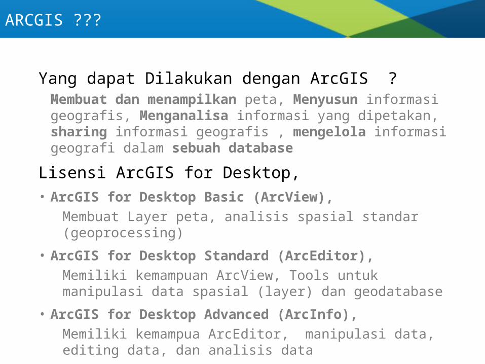
Yang dapat Dilakukan dengan ArcGIS ?Membuat dan menampilkan peta, Menyusun informasi geografis, Menganalisa informasi yang dipetakan, sharing informasi geografis , mengelola informasi geografi dalam sebuah database
Lisensi ArcGIS for Desktop, • ArcGIS for Desktop Basic (ArcView),
Membuat Layer peta, analisis spasial standar (geoprocessing)
• ArcGIS for Desktop Standard (ArcEditor),Memiliki kemampuan ArcView, Tools untuk manipulasi data spasial (layer) dan geodatabase
• ArcGIS for Desktop Advanced (ArcInfo),Memiliki kemampua ArcEditor, manipulasi data, editing data, dan analisis data
ARCGIS ???
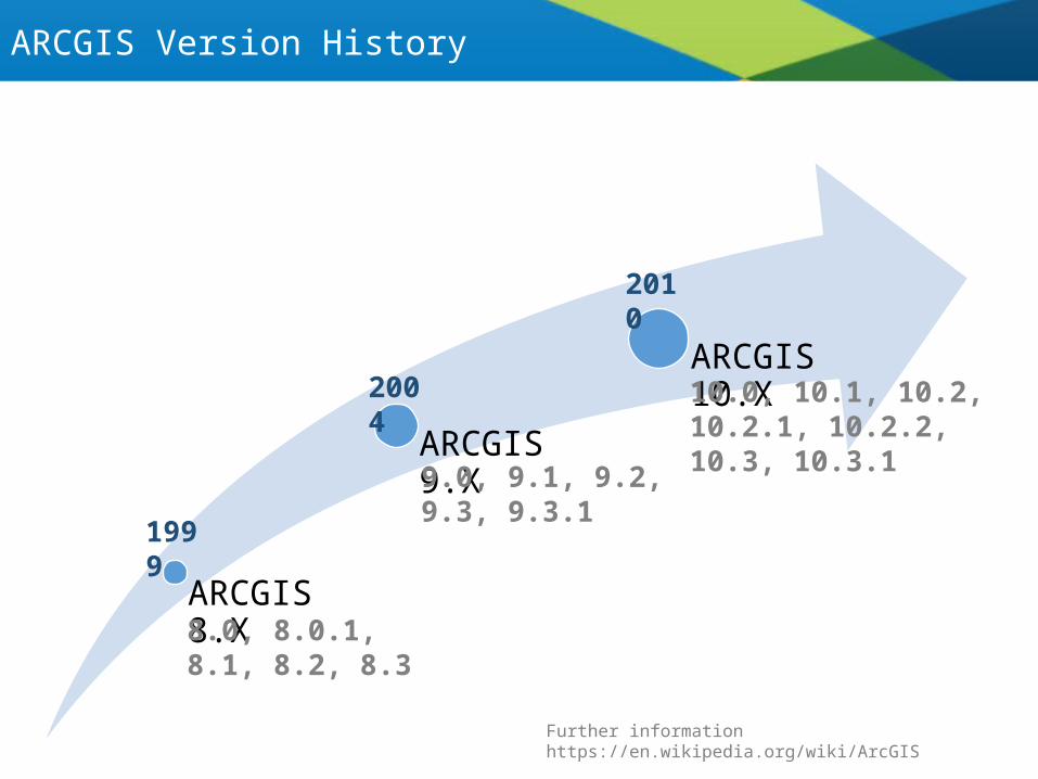
ARCGIS 8.X
ARCGIS 9.X
ARCGIS 10.X
8.0, 8.0.1, 8.1, 8.2, 8.3
Further information https://en.wikipedia.org/wiki/ArcGIS
9.0, 9.1, 9.2, 9.3, 9.3.1
10.0, 10.1, 10.2, 10.2.1, 10.2.2, 10.3, 10.3.1
1999
2004
2010
ARCGIS Version History
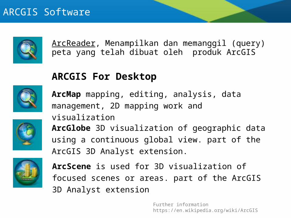
ArcReader, Menampilkan dan memanggil (query) peta yang telah dibuat oleh produk ArcGIS
ARCGIS Software
ARCGIS For Desktop
ArcMap mapping, editing, analysis, data management, 2D mapping work and visualization
ArcGlobe 3D visualization of geographic data using a continuous global view. part of the ArcGIS 3D Analyst extension.
ArcScene is used for 3D visualization of focused scenes or areas. part of the ArcGIS 3D Analyst extension
Further information https://en.wikipedia.org/wiki/ArcGIS
Why ARCGIS
Further information : https://en.wikipedia.org/wiki/List_of_geographic_information_systems_software#Desktop_GIS
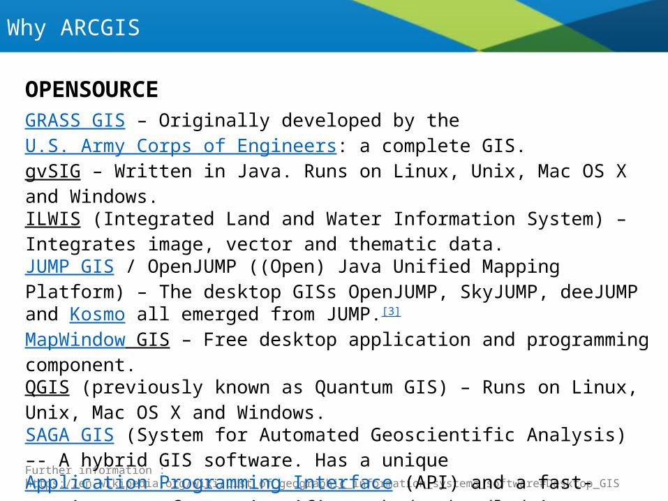
GRASS GIS – Originally developed by the U.S. Army Corps of Engineers: a complete GIS.gvSIG – Written in Java. Runs on Linux, Unix, Mac OS X and Windows.ILWIS (Integrated Land and Water Information System) – Integrates image, vector and thematic data.JUMP GIS / OpenJUMP ((Open) Java Unified Mapping Platform) – The desktop GISs OpenJUMP, SkyJUMP, deeJUMP and Kosmo all emerged from JUMP.[3]
MapWindow GIS – Free desktop application and programming component.QGIS (previously known as Quantum GIS) – Runs on Linux, Unix, Mac OS X and Windows.SAGA GIS (System for Automated Geoscientific Analysis) –- A hybrid GIS software. Has a unique Application Programming Interface (API) and a fast-growing set of geoscientific methods, bundled in exchangeable Module Libraries.uDig – API and source code (Java) available.
OPENSOURCE

Why ARCGIS
Further information : https://en.wikipedia.org/wiki/List_of_geographic_information_systems_software#Desktop_GIS
Autodesk – Products that interface with its flagship AutoCAD software package include Map 3D, Topobase, and MapGuide.Bentley Systems – Products that interface with its flagship MicroStation software package include Bentley Map and Bentley Map View.ENVI – Utilized for image analysis, exploitation, and hyperspectral analysis.ERDAS IMAGINE by ERDAS Inc – Products include Leica Photogrammetry Suite, ERDAS ER Mapper, and ERDAS APOLLO.Esri – Products include ArcMap, ArcGIS, ArcSDE, ArcIMS, ArcWeb services and ArcGIS Server.Intergraph – Products include G/Technology, GeoMedia, GeoMedia Professional, GeoMedia WebMap, and add-on products for industry sectors, as well as photogrammetry.MapInfo by Pitney Bowes Software – Powerful desktop GIS MapInfo Professional is enhanced with many plug-ins including MapInfo Drivetime for route analysis,
COMMERCIAL

Instalasi Perangkat Lunak
Further information : http://resources.arcgis.com/en/help/system-requirements/10.2/index.html#//015100000002000000
Platform : Windows 8, 7, Vista, XPHardwareCPU : 2.2 GHz minimum ; Hyper-threading (HHT) or Multi-core recommendedProcessor : Intel Pentium 4, Intel Core Duo, or Xeon Processors; SSE2 minimumMemory : 2 GB minimum Display : 24-bit color depthScreen Resolution : 1024 x 768 recommended minimum at normal size (96 dpi)Hardisk : 2.4 GB Video/Graphics adaptor : 64 MB RAM minimum, 256 MB RAM or higher recommended. NVIDIA, ATI, and Intel chipsets supported.
SoftwareNET Framework 3.5 SP1 Internet Explorer requirementPython requirement for Geoprocessing:
Instalasi Perangkat Lunak
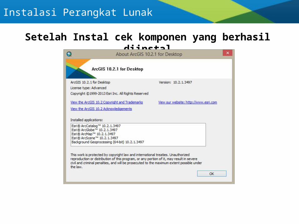
Setelah Instal cek komponen yang berhasil diinstal

ARCGIS Antar Muka
12
3
4
5
1 : Tab menu 2 : Toolbar3 : Table of Content
4 : Layout and map View5. Catalog

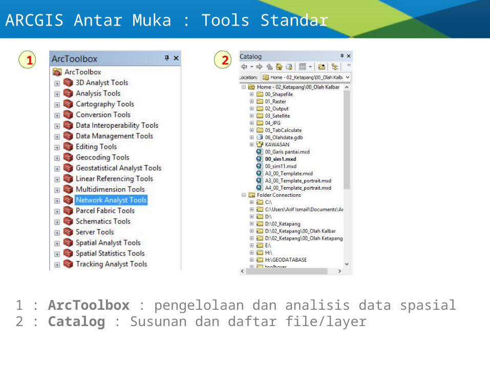
ARCGIS Antar Muka : Tools Standar
1
2
3
4
5
1 : menu standar, pengelolaan file mxd dan shortcut toolbar2 : manipulasi/edit data spasial3 : navigasi peta pada map view4 : navigasi peta pada layout view5 : membuat graphic dan label6 : menabah label/toponimi peta
6
ARCGIS Antar Muka : Tools Standar
1
1 : ArcToolbox : pengelolaan dan analisis data spasial2 : Catalog : Susunan dan daftar file/layer
2
1) Instal perangkat lunak ArcGIS
2) Buat laporan hasil praktikum, memuat:Pendahuluan, Tujuan, Langkah-langkah, Hasil praktikum, Kesimpulan
3) Hasil praktikum berupa :Praktek membuka data spasialPenjelasan detil dari komponen pada tools standarPenjelasan detil dari komponen arctoolbox dan catalog
4) Hasil praktikum di cetak pada kertas A4, bolak-balik, dan dikumpulkan pada pertemuan berikutnya
5) Terima kasih, Selamat Belajar .. Kirim ke “[email protected]”
ARCGIS Antar Muka : Tugas
7 Kelompok
1. Kemacetan : - Annisa, - Nurdin, - Jan (+)2. Pertanian : - Fikri, - Debby, - Fazrin (-)3. Perkebunan : - Joi, - Herdi, - Tri Hartono (+)4. Penyakit : - Fahmi, Fadly (+)5. Bank : - Dinar, - Asep (+)6. Pendidikan : - Fazl, - M. Hidayat, - Teguh (-)7. Longsor : - Khairy, - Biyan Rezha (-)
ARCGIS Antar Muka : Tugas
