teledyne odom mb1 survey of the rigolets, …209.240.133.120/media/user/file/press...
TRANSCRIPT

©Teledyne Odom Hydrographic, 2012 1
TELEDYNE ODOM MB1 SURVEY OF THE RIGOLETS, LOUISIANA, USA, 17 JULY 2012 Mike Redmayne MSc IHO/FIG Cat A, Teledyne Odom Hydrographic OBJECTIVE Following extensive production trials, the MB1 was used to conduct a full survey of an open water area in southern Louisiana. This was in order to obtain a full dataset in real world conditions using standard hydrographic survey procedures. For this survey, the Teledyne Odom hydrographic vessel 'Echotrac II' was used. The equipment installed was as follows:
Variable Sensor Stated Accuracy Notes
Depth MB1 3.6cm Range resolution Bow mounted
Motion Teledyne TSS DMS05 0.05 degrees Pitch/Roll5cm/5% heave
CoG mounted Real time heave used
Heading Teledyne TSS Meridian Gyro 0.2 degrees
Position C&C C‐Nav 3050 10‐15cm RMS Horizontal Real time position used
Sound Velocity (Real Time)
Teledyne Odom Digibar V 0.2m/s Connected to multibeam head
Sound Velocity (Profile) Teledyne Odom Digibar S 0.05m/s RMS
Acquisition MB1 software (Image)Hypack/Hysweep
N/A Hypack HSX Data used for analysis
SETUP The MB1 was installed on the Echotrac's retractable bow mount, and the other sensors were previously installed on the vessel. The MB1 control software was run on a quad core i7 Laptop, and Hypack on the vessel's PC.
Block diagram of the MB1 setup Teledyne Odom Survey vessel 'Echotrac II'

©Teledyne Odom Hydrographic, 2012 2
SURVEYING CONDITIONS The weather was fine during the survey, with an average pitch and roll of the vessel of around 1 and 2 degrees, respectively.
Typical survey conditions taken from motion sensor data
SURVEY AREA The area chosen for the survey is the waterway that joins Lake Pontchartrain and Lake Borgne, called the Rigolets. It was chosen as an area with varied underwater features and depths, ranging from 34m to the surface.
Chartlet taken from NOAA chart 11367 showing survey area (green line). Note depths are in feet.
One disadvantage to the choice of this area was the large number of fish seen in the water column, from looking at the side scan imagery gathered by MB1 we can see this.

©Teledyne Odom Hydrographic, 2012 3
An example of sidescan data obtained during the survey using MB1 shown in Hypack ‐ note the large
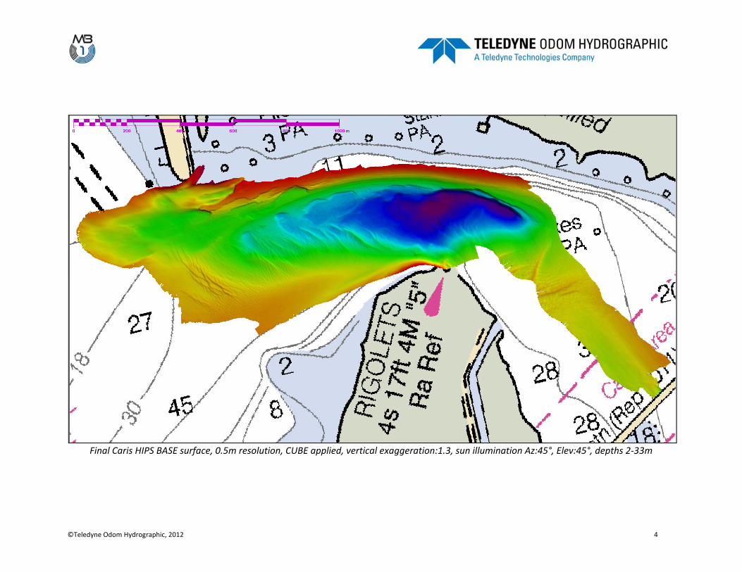
number of fish in the water column RESULTS The MB1 performed well during the survey, with the only notable issue being the number of fish seen near the seabed in the survey data. These were easily removed in CUBE processing with an additional 30 minutes of manual analysis. The majority of the survey area was determined to have an uncertainty of <0.25m at 1σ, and a CUBE hypothesis count of 1.
©Teledyne Odom Hydrographic, 2012 4
Final Caris HIPS BASE surface, 0.5m resolution, CUBE applied, vertical exaggeration:1.3, sun illumination Az:45°, Elev:45°, depths 2‐33m

©Teledyne Odom Hydrographic, 2012 5
3D View of BASE surface looking NE, vertical exaggeration:2
©Teledyne Odom Hydrographic, 2012 6
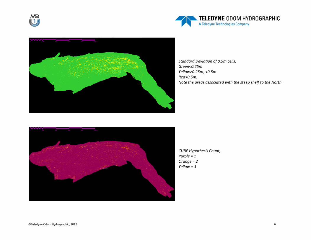
Standard Deviation of 0.5m cells, Green<0.25m Yellow>0.25m, <0.5m Red>0.5m. Note the areas associated with the steep shelf to the North
CUBE Hypothesis Count, Purple = 1 Orange = 2 Yellow = 3
©Teledyne Odom Hydrographic, 2012 7
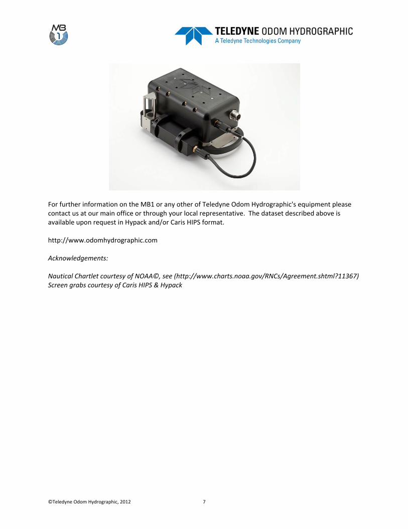
For further information on the MB1 or any other of Teledyne Odom Hydrographic's equipment please contact us at our main office or through your local representative. The dataset described above is available upon request in Hypack and/or Caris HIPS format. http://www.odomhydrographic.com Acknowledgements: Nautical Chartlet courtesy of NOAA©, see (http://www.charts.noaa.gov/RNCs/Agreement.shtml?11367) Screen grabs courtesy of Caris HIPS & Hypack