vegetation _ ghana
TRANSCRIPT

8/2/2019 Vegetation _ Ghana
http://slidepdf.com/reader/full/vegetation-ghana 1/21
2. Study sites, cropping systems and profile of farmers
5
2. Study sites, cropping systems and profile of farmers
Most information in this book was obtained from our field studies carried out in Ghana’s
three major cities of Accra, Kumasi and Tamale. Additional surveys were carried out in Cape
Coast and Takoradi. This chapter gives a description of the cities in view of urban
agriculture. It also shows the main cropping systems and characteristics of urban farmers
involved in irrigated open-space vegetable production.
2.1. The study sites in Ghana
Ghana lies at the shore of the Gulf of Guinea in West Africa and occupies a total area of about
24 million ha. To the North, it borders Burkina Faso, Togo to the East and Ivory Coast to the
West. The country is divided into ten administrative regions and six ecological zones,
dominated by semi-deciduous forest and Guinea savannah (Figure 2.1).
Figure 2.1: A map showing the location of the major study cities in Ghana
Sahel Zone
Sudan Savanna
Guinea Savanna
Coastal SavannaTropical rain forest
Kumasi
Accra
Tamale
Ouagadougou
Ghana
Mali
Ivory Coast T o g o
Burkina Faso
Gulf of Guinea
B eni n
Transitional
ZoneMoist semi-deciduous Forest
Takoradi Cape Coast

8/2/2019 Vegetation _ Ghana
http://slidepdf.com/reader/full/vegetation-ghana 2/21
2. Study sites, cropping systems and profile of farmers
6
The topography is predominately gently undulating with slopes less than 5%. Rainfall ranges
from 600 mm/yr in the coastal zone to 2200 mm/yr in the southwestern rainforests. In most
parts of the country there is one distinct rainy season and one dry season lasting longer in the
Northern parts of Ghana than in the South (Quansah, 2000).About 64% of Ghana’s surface falls on the Volta Basin, but with Tamale only one of Ghana’s
major cities. Ghana has a population of about 19 million, with an annual growth rate of 2.7%
and its population density stands at 79 persons per km2, going up from 55 persons per km2 in
1984. Forty four percent of the population lives in urban areas. The Greater Accra region
(hosting the Capital City Accra) is the most densely populated with almost 900 persons per
sq. km and the most urbanized as 88% of its almost 3 million people live in the urban areas
(Ghana Statistical Service, 2002).
Agriculture is the mainstay of the Ghanaian economy. It contributes to 36% of the GDP and
employs 60% of Ghana’s labor force (ISSER, 2002). About 36% of Ghana’s population lives
below the poverty line (US$ 1/day) (Lamptey, 2006). Poverty is substantially higher in rural
areas and northern Ghana than in urban areas and southern Ghana (Ghana Statistical Service,
1999).
The three largest cities, Accra, Kumasi and Tamale, were selected for this study as they
represent a cross-section through the agro-ecological zones of Ghana. Accra lies in the
Greater Accra and administrative region and falls under the coastal savannah zone, Kumasi in
the Ashanti Region falls under the humid forest zone while Tamale is in the Northern Region
and falls under the Guinea savannah zone (Figure 2.1, Table 2.1). The following pages
present brief descriptions of the three cities and their urban agricultural activities with focus
on irrigated open-space farming. Some additional information is provided for Takoradi and
Cape Coast.
Table 2.1: Mean annual climate data of Accra, Kumasi, Tamale
Rainfall
(mm)
Tempe-
rature(
0C)
Relative
humidity(%)
Sunshine
duration(hrs)
Wind
velocity(km/day)
Potential
evaporation(mm)
Accra 810 27.1 81 6.5 251 1504
Kumasi 1420 26.1 77 5.4 133 1357
Tamale 1033 28.1 61 7.3 138 1720
Source: Agodzo et al., 2003

8/2/2019 Vegetation _ Ghana
http://slidepdf.com/reader/full/vegetation-ghana 3/21
2. Study sites, cropping systems and profile of farmers
7
2.2 Irrigated urban agriculture in Accra
Accra is the capital city of Ghana and covers an area of about 230 to 240 km². In its current
administrative boundary, it has an estimated population of 1.66 million (Ghana Statistical
Service, 2002). Accra’s population growth rate is about 3.4 % annually, which is constrained
by the outdated boundary of the city. The actual population growth takes place behind this
boundary where the Ga and Tema districts grew between 1984 and 2000 at a rate of 6.4 and
9.2%, respectively. Including both districts, we get the functional boundary of (Mega) Accra,
as the urban dwellers perceive it, with 2.7 million inhabitants (Twum-Baah, 2002). About 60
percent of Accra’s population lives in informal settlements or slums in the centre of the city
while the middle and upper class moves to its periphery. About 10 % of Accra’s inhabitants
are Moslems in an otherwise mostly Christian community.
Accra lies within the coastal-savanna zone (Figure 2.1) with low annual rainfall averaging
810 mm distributed over less than 80 days (Table 2.1). The rainfall pattern of the city is
bimodal with the major season falling between March and June, and a minor rainy season
around October. Mean temperatures vary from 24 ºC in August to 28 ºC in March. Natural
drainage systems in Accra include streams, ponds and lagoons (e.g., Songo, Korle and
Kpeshie). Floodwater drains and gutters are used for grey water, and often drain into the
natural system, polluting heavily the lagoons and Accra’s beaches.
In Accra, about 680 ha are under maize, 47 ha under vegetables and 251 ha under mixed
cereal-vegetable systems (Figure 2.2; 2.3). Irrigated urban vegetable production takes place
on more than seven larger sites. IWMI (unpublished) estimated on average about 100 ha
under vegetable irrigation in the dry season. Some of the sites have been in use for more than
50 years (Anyane, 1963).
About 50-70 additional hectares are distributed over 80,000 tiny backyards (often just a few
plantain and chicken) involving nearly 60% of Accra’s houses (IWMI and RUAF, unpubl.).
This figure is much higher than the one of Maxwell and Armar-Klemesu (1999) who surveyed
mostly low-income and high-density suburbs.
The extent of the peri-urban area of Accra was estimated following the methodologicalapproach described by Adam (2001) for Kumasi. Based on the results, we propose an average
radius of 38 km from the city center (Figure 2.4), with more outreach along the Accra-Kumasi
road, and less in-between the major roads. In this peri-urban area, farmland is increasingly
converted into settlements but agriculture still plays a significant role. A major feature are
large-scale pineapple plantations which support, among others, the European market.

8/2/2019 Vegetation _ Ghana
http://slidepdf.com/reader/full/vegetation-ghana 4/21
2. Study sites, cropping systems and profile of farmers
8
MALAM
AWOSHIE
ACHIMOTA
DOME
OFANKOR
MADINAOGBODZO
M O T O R WA Y
LA
ACCRA
37 MILITARY
CANTONMENTS
AIRPORT
TESHIE
MAMPROBI
LASHIBI
Type - Area (ha)FOREST - 382
MAIZE - 680
MIXED - 251
OTHERS - 312PALM - 70
VEGETABLE - 47
LAKE/RIVERS
ROADS
KORLE-BU
LEGON
TEMA
Figure 2.2: Map showing open spaces and (farming) activities on them in Accra (Kufogbe et al., 2005)

8/2/2019 Vegetation _ Ghana
http://slidepdf.com/reader/full/vegetation-ghana 5/21
2. Study sites, cropping systems and profile of farmers
9
Figure 2.3: Vegetable producing sites in centralAccra (IWMI, unpubl.)
Accra
Rivers
Roads
Vegetable Farming
Sugarcane and Taro in Streams
Densely Populated Areas
Drawn By: Forkuor Gerald
Date: June 11, 2004
Dzorwulu
CSIR
LaGBC
Korle-bu
0 1 20.5Kilometers
Accra
Marine Drive Marine Drive
LaGBC
Korle Bu
Dzorwulu
CSIR

8/2/2019 Vegetation _ Ghana
http://slidepdf.com/reader/full/vegetation-ghana 6/21
2. Study sites, cropping systems and profile of farmers
10
Figure 2.4: Approximate boundary between Rural and Peri-Urban Accra. The identification
of the boundary followed the methodology described by Adam (2001).
Major irrigated vegetable farming sites in Accra
In Accra, there are about 800-1000 vegetable farmers of whom 60% produce exotic and 40%
indigenous local or traditional vegetables. Some of the modern or exotic crops cultivated are
lettuce, cabbage, spring onions, and cauliflower while the more traditional crops are tomatoes,
okro, garden eggs (aubergine) and hot pepper. Plot sizes under cultivation in the city range
between 0.01-0.02 ha per farmer, and max. 2.0 ha in peri-urban areas. The plot sizes of most
of these sites have diminished over time because of land loss to estate development and
widening of drains. This has led to reduced land reservations along the drains which used to
be cultivated. An additional problem faced by farmers in relation to their farm size is tenure
insecurity and low soil fertility. The locations of some of the irrigated (open-space) vegetable
farming sites in the city is shown in Figures 2.2 and 2.3.
Some mayor areas are:
o “Marine drive” at the Independence Square: Farming in the area began before 1983 by a
religious organization and was aimed at providing employment for the youth and
Nsamwan
ACCRA

8/2/2019 Vegetation _ Ghana
http://slidepdf.com/reader/full/vegetation-ghana 7/21
2. Study sites, cropping systems and profile of farmers
11
reclaiming the land. The land being cultivated belongs to the department of Parks and
Gardens and was originally zoned by AMA as an open space in line with the
beautification of the metropolis. However, lack of funds, time and logistics have
motivated the Department of Parks and Gardens to enter into informal agreement with
farmers and release the land to them to promote ‘‘agro-forestry with inter-cropping’’.Though they have no formal farmer’s organization, farmers have a spokesman. The site
currently has 98 farmers (97 male, 1 female) aged between 18 and 60 years. The potential
farming area covers 3.6 ha. Water is provided through a narrow wastewater drain
connecting the inner-urban area called “Ministries” and the ocean.
o “Dzorwulu/Plant Pool”. The site covers an area of 15 ha. It is divided into two sites by a
major road with in total about 60 male farmers and 2 female farmers. One part, “Plant
Pool”, next to the high-tension area of Volta River Authority (VRA) has 34 farmers, two
of whom are women. The other side has 28 male farmers. A mutual agreement has been
formalized with VRA for farming in the area as a way of maintaining it and to prevent any
non-agricultural encroachment. River Onyasia cuts across the farming sites. The river is
channeled in this part of Accra like a drain and has a similar function. Some farmers use
pipe-borne water, most however water from the major drain or smaller drains channeled
into shallow reservoirs (dug-outs). There are about 77 of such small ponds on this site.
Some are also filled with piped water.
o “La”: This is the oldest and largest irrigated site in Accra with up to 400 vegetable
farmers. The majority of them use wastewater from the drains of the nearby (military)
“Burma” camp. About 50 farmers use pipe-borne water while five use water from a
treatment pond of the only partially functioning treatment plant. It is the only site in
Ghana where “treated” wastewater is used and in Accra where furrow irrigation is
practiced. La is also unique as there are an equal number of men and women farming. The
site has a functional farmers association and measures in total nearly 100 ha, with about
40% under irrigation, otherwise rainfed farming or fallow land.
o “Korle-bu”: The farming site neighbors the largest hospital in Ghana. Most farmers are
junior hospital staff like watchmen, cleaners, etc. who farm to supplement their income.
The cultivated land area covers about 10 ha, but is decreasing due to building activities.
Several attempts have been made at forming a farmers association but without success.

8/2/2019 Vegetation _ Ghana
http://slidepdf.com/reader/full/vegetation-ghana 8/21
2. Study sites, cropping systems and profile of farmers
12
The site has about 80 farmers (only one female), most of them being migrants from the
northern regions of Ghana and Burkina Faso. The land belongs to the hospital and farming
is done under an informal arrangement to keep the area clean and prevent non-agricultural
encroachment. Water is derived from drains, which pass through the hospital compound
and staff flats.
Other sites are, for example in the Airport Residential Area around the CSIR and IWMI
offices or close to the Ghana Broadcasting Company (GBC).
2.3 Irrigated urban agriculture in Kumasi
Representing the middle belt of Ghana, Kumasi is the capital town of Ashanti Region and the
second largest city in Ghana with a population of 1.0 million and an annual growth rate of
5.9% (Ghana Statistical Service, 2002). Daytime population – attracted by Kumasi’s large
central market - is estimated at 1.5 to 2 million people. Kumasi itself has a total area of 225
km² of which about 40% is open land. Kumasi has a semi-humid tropical climate and lies in
the tropical forest zone (Figure 2.1) with an annual average rainfall of 1420 mm with about
120 days on which it rains in the year. The rainfall pattern of the town is bimodal with the
major season falling between March and July and a minor rainy season around September and
October. The mean monthly temperature of the area ranges from 24 0C to 270C. Important
streams and rivers include the Owabi River, which flows through the suburb of Anloga; Subin
River, which passes through Kaasi and Ahensan; and Wiwi River, which runs through the
local university campus (KNUST). Due to the hilly landscape of Kumasi, most streams run
through inland valleys unsuitable for construction and of high value for urban vegetable
production.
The population of Kumasi comprises mainly Ashanti and other ethnic groups, with about 20%
being Moslems. At least two of three households have some kind of backyard farming. A
much higher percentage has at least a few plantain crops or chickens (IWMI, unpubl.). This
corresponds with the estimates of KNRMP (1999). The peri-urban area of Kumasi has a
radius of approximately 40 km from the city center (Blake and Kasanga, 1997, Adam, 2001).
It is characterized – among others - by a concentration of large poultry farms (the largest farm
has depending on the season up to 300,000 birds). Lying in the “tuber belt” of West Africa,
cassava, plantain, maize and other traditional staple food crops are dominant on upland sites,
often accompanied by dry-season vegetable farming especially along streams.

8/2/2019 Vegetation _ Ghana
http://slidepdf.com/reader/full/vegetation-ghana 9/21
2. Study sites, cropping systems and profile of farmers
13
Major irrigated vegetable farming sites in Kumasi
In urban Kumasi, most land where farming is done belongs to government institutions, private
developers etc. There are about 41 ha in the urban area under vegetable irrigation1
while the
peri-urban area has more than 12,000 hectare under irrigated vegetable farming mostly duringthe dry season (Cornish and Lawrence, 2001), twice as much as under formal irrigation in the
whole country. The main farming sites in the urban area are shown in Figure 2.5.
Some well-known sites are:
§ Gyinyase/Engineering: This is the largest urban vegetable-farming site in Kumasi (21.8
ha). It is located next to the local university (KNUST2) in an inland valley. The site has a
diversity of crops, and farmers practice in part organic farming. Shallow wells are used
extensively and there is a well-established farmers organization.
§ Georgia Hotel: This farming site is located behind Georgia Hotel and covers about 0.4
ha. It has 3 male farmers with their families cultivating spring onions, cabbage, green
pepper, garden eggs and red onions. The land belongs to the hotel and the farmers are
allowed to cultivate it. This is the only urban site in Ghana where farmers use sprinkler
irrigation so far. Farmers use pipe borne water although the pipe connection does not
appear to follow official regulations.
§ “D-Line/Weweso”: Covering an area of about 3.1 ha, this site is located beside the
Kumasi-Accra road (next to the KNUST police station) and farmers predominantly
cultivate spring onions. It has about 30 farmers organized in an association. The water
source is a small stream, which receives untreated effluents from a significant number of
households.
1Total area used for open space farming in the city (incl. tubers, cereals) is about 70 ha.
2 Kwame Nkrumah University of Science and Technology

8/2/2019 Vegetation _ Ghana
http://slidepdf.com/reader/full/vegetation-ghana 10/21
2. Study sites, cropping systems and profile of farmers
14
Towns
Major Roads
Rivers
Densely populated Areas
Sugarcane & Taro in Streams
Kumasi City Boundary
Vegetable farming
Northern
Volta
Ashanti
Brong Ahafo
Western
Eastern
Upper West
Central
Upper East
Greater Accra
Kwadaso
Gyenyasi
Georgia
AirportManhyia
D-Line
Hall 6
0 1 20.5Kilometers
Drawn by: Gerald Forkuor
Date: June 11, 2004
Kumasi
Figure 2.5: Vegetable producing sites in urban Kumasi (IWMI, unpubl.)
Sugarcane and Taro in
Inland valleys/streams
City boundary

8/2/2019 Vegetation _ Ghana
http://slidepdf.com/reader/full/vegetation-ghana 11/21
2. Study sites, cropping systems and profile of farmers
15
2.4 Irrigated urban agriculture in Tamale
Tamale is the capital of the Northern Region. The Tamale district is covering a large area of
about 930 km2 including the city itself and about 30 surrounding villages. Urban Tamale
extends up to 10 km from the city center, while peri-urban Tamale extends in average up to
40 km along its major East-West and North-South roads, but only about 15 km in-between
(IWMI, unpubl,)3.
The population of Tamale city is about 200,000 and of the whole district about 300,000 with a
comparatively low growth rate of 2.5% (Ghana Statistical Service, 2002). Tamale lies in the
Guinea-savanna belt (Figure 2.1) with only one rainy season from April/May to
September/October, followed by a prolonged dry season. As a result the Municipality is
poorly endowed with water bodies. There are few seasonal streams, with enough water during
the rainy season but which dry up during the dry season. However, the average annual rainfall
is higher than in Accra with about 1033 mm over about 95 days of intense rain. The dry
season lasts usually from November to March. Maximum day temperatures range from 33ºC –
42ºC while minimum night temperatures range from 20ºC – 22ºC. Average relative humidity
is 90% during the day and 96% in the night.
Tamale generally lags behind the municipalities in the southern part of the country in
providing various services. The dominant ethnic group is Dagomba with Dagbani the widely
spoken local language. About 60% of its population are Muslims. Every fourth household has
a backyard with at least a few crops or poultry (IWMI, unpubl.).
Main irrigated vegetable farming sites in Tamale
As there is no main stream passing through Tamale and since the groundwater table is low,
most farming is done along wastewater drains, near dams with small reservoirs, broken
sewers or near dugouts. About 40% of the vegetable farmers are farming all year round.
Fifty-two per cent depend on polluted water sources (Zibrilla and Salifu, 2004). Most
attempts to explore groundwater in the municipality failed. The average depth of
successful wells is about 60 meters.
Figure 2.6 shows some of the major farming sites in and around the city center. The total area
under informal irrigation is about 33-40 ha in urban Tamale and 70 ha in the urban fringe.
Apart from a few sites, farmers in the other areas cannot farm year-round due to lack of water,
3 The assessment of the area was based on the approach outlined by Adam (2001).

8/2/2019 Vegetation _ Ghana
http://slidepdf.com/reader/full/vegetation-ghana 12/21
2. Study sites, cropping systems and profile of farmers
16
<Double-click here to enter title>
Major roads
Minor Roads
Rivers
Sugarcane & Taro in Stream
Vegetable farming
Densely Populated Area
Forest Reserve
Drawn By: Forkuor Gerald
Date: June 11, 2004
Zagayuli
Bulpeila
Sagnani
0 1 20.5Kilometers
Tamale
Gumbihene
Zagyuri
Sangani
Builpela
Gumbihene
or because landowners (who are also farmers) take back their land in order to grow their own
cereals during the rainy season (Zibrilla and Salifu, 2004; Amarchey, 2005).
Figure 2.6: Selected urban vegetable production sites in Tamale (IWMI, unpubl.)
Examples of some well-known urban farming sites are:
§ Builpela (Bulpeila): this site is about 2 km from the center of Tamale. Farmers use a
dam that was built in 1960 to supply water for domestic use, livestock and vegetable
cultivation. The area under vegetable cultivation is about 2.6 ha. Other reports mention
6.8 ha (Zibrilla and Salifu, 2004).
§ Sangani: it is located 2 km North-East of Tamale town center. Farmers use a dugout
well meant for domestic use. Depending on the source, the area under cultivation varies
between 0.5 to 4 ha.
§ Water Works: named after a dam originally built to provide water for Tamale
Municipality, the reservoir is now heavily polluted. Water flows through it and is used
by farmers who have farms next to the stream originating from the dam. Vegetable

8/2/2019 Vegetation _ Ghana
http://slidepdf.com/reader/full/vegetation-ghana 13/21
2. Study sites, cropping systems and profile of farmers
17
irrigation at Gumbihene Water Works, Gumbihene New Dam and Gumbihene Old
Dam cover in total 13.5 to 22 ha.
§ Zagyuri: this site is near Kamina Barracks and farmers use untreated sewage from a
broken sewer. The site is 8 km from the city center and covers according to different
sources in total about 7-12 ha.
In Tamale, some farmer associations, NGOs, municipal authorities and research
institutions form the ‘Urban Agriculture Network – Northern Ghana’ under facilitation of
Action Aid . A main task of the network is advocacy for land security (Amarchey, 2005).
2.5 Irrigated urban agriculture in other cities
Cape Coast: The Central Region in general and the Cape Coast municipality in particular are
known for their high tourist potential. A large number of beach resorts, hotels and guest
lodges warrant a high and unceasing demand for vegetables within this area. However, our
surveys showed that there is almost no irrigated vegetable farming taking place within Cape
Coast except for the premises of Cape Coast University where almost a hectare of exotic
vegetables is cultivated year round using pipe-borne water. The bulk (over 90 %) of the
vegetables consumed in and around the Cape Coast municipality comes from as far as Togo
or Kumasi and rural areas surrounding the Cape Coast District (e.g. Nsadwir).
Based on interviews and observations, reasons assigned to the insignificant level of urban
vegetable production include: (1) general scarcity of non-saline surface or ground waters
including perennial streams; (2) saline nature of soils, and (3) unsuitable hilly topography
with flood-prone flat lands. Particularly during the dry season (October-March) when
vegetable prices would allow high returns, the biophysical potential for irrigated urban
agriculture is very low. Significantly fewer migrants from the North (than e.g. in Accra) and a
local preference for fishing are further factors limiting the in-situ development of irrigated
vegetable production.
Takoradi: In the Takoradi municipality, there exist a number of urban and peri-urbanirrigated vegetable production sites where a considerable amount of vegetables is produced.
These are located in areas commonly known as Air force, Airport Ridge, PTC4 and
Kwesimintsim (near ‘Obiri’ lotteries). The total area covers about 3 hectares (Figure 2.7).
Farm sites at both the Air force and Airport ridge are all located on lands that belong to the
4 Pioneer Tobacco Company©

8/2/2019 Vegetation _ Ghana
http://slidepdf.com/reader/full/vegetation-ghana 14/21
2. Study sites, cropping systems and profile of farmers
18
Air force. Almost every farmer cultivates year round. Majority of farmers in Takoradi use
streams as water source. Streams crossing the town are highly polluted as they function as
natural drains for urban wastewater.
Figure 2.7: Location of some urban vegetable production sites in Takoradi (IWMI, unpubl.)
2.6 General farming characteristics
Open space vegetable farming is mainly for commercial purposes. Only farmers specialized in
traditional (indigenous) vegetables consume a part of their produce. In Kumasi, vegetable
farming is done all-year-round, whereas in Accra and especially in Tamale many of the
vegetable sites are (also) used for maize and sorghum in the rainy season. Also in peri-urban
areas, in particular around Kumasi, vegetables are mostly produced in the dry season when
Takoradi

8/2/2019 Vegetation _ Ghana
http://slidepdf.com/reader/full/vegetation-ghana 15/21
2. Study sites, cropping systems and profile of farmers
19
prices are high. Farm sizes are increasing from urban to peri-urban areas with usually less
than 0.1 ha in the cities and up to 1.5 ha in peri-urban areas. Vegetable farming is done on
raised beds and an average bed covers an area of 3-8 m2. Due to high labor requirements (land
preparation, weeding, watering etc) farmers with bigger land areas have to hire labor or rent a
water pump. Urban farmers use their own labor, although a “brother” might help. In peri-urban areas more family labor is used. Poultry manure is all-over the preferred and cheapest
nutrient source, but also fertilizer is used, especially on cabbage.
Most urban farming sites are on lands belonging to government institutions and departments
and private developers who have not yet started constructing. Preferably, farming is done in
reserved areas along streams and other water sources. Farmers normally do not pay for such
land and only have an informal agreement with the landowner. As such there is no security of
tenure as they are allowed to farm only as long as the owners do not need the land. On other
sites, belonging for example to the Air force authorities in Takoradi, farmers pay a fee to use
the land. Such arrangements are, however, seldom enforced. In general, as you move to the
peri-urban areas, land tenure becomes more secure because land is owned under customary
rights and distributed according to traditional regulations (Flynn-Dapaah, 2002). One
exception in the urban context is the site of La, Accra. The customary owners of land are the
members of the La stool, one of the Ga chieftaincies. Non-indigenous farmers who want to
farm in the area have to enter into some kind of agreement with customary owners by paying
rent (e.g. US$ 4 per ha/season) or agree on sharecropping. With the existence of inheritance
land tenure arrangement, a piece of land continues to remain in a family for a long period of
time until the land is disposed off by the family. Nevertheless, parts of the La land has been
cultivated for more than 100 years. For a more detailed account on land tenure and rights in
and near Accra, see Flynn-Dapaah (2002) and Obuobie et al. (2003).
More than 15 types of vegetables are cultivated in the study areas. Table 2.2 shows that the
most commonly grown urban vegetables are also the most perishable (leafy) ones, which have
to be produced in market proximity as long as cold transport is lacking. These are often
“exotic” (non-traditional) vegetables, which reflect imported diets and are consumed raw in
salads, such as lettuce, spring onions, and cabbage. In peri-urban areas, on the other hand,
more traditional diet vegetables like ayoyos (Corchorus sp) and alefi ( Amaranths) or less
perishable (fruity) vegetables like garden eggs and tomatoes are grown. Another noticeable
feature is the specialization that sometimes occurs in farming sites. For instance, farmers in

8/2/2019 Vegetation _ Ghana
http://slidepdf.com/reader/full/vegetation-ghana 16/21
2. Study sites, cropping systems and profile of farmers
20
D-line in urban Kumasi predominantly plant spring onions while their counterparts at
Gyinyase plant lettuce. It is summarised that availability of water is one of the factors
influencing such a decision and the nature of the soil as well. Specialization is another reason;
in some villages around Kumasi, farmers prefer certain vegetables, while in the neighbouring
villages other vegetables are grown. In Tamale, quite a number of local vegetables arecultivated in the urban areas, a response to a less multi-cultural demand.
Table 2.2: Common crops and crop combinations in urban Kumasi (IWMI, unpubl.)
Main crops Associated crops
Crops Harvest/year Crop Harvest/year
Lettuce 9-10 Cabbage 1
Spring onions 6 Cabbage 2
Cabbage/cauliflower 3-4 None None
Carrots1 6 Spring onions 2
Green pepper2 6 Lettuce 6
Radish: Red
Radish: White
8
5
Green pepper 2
Ayoyo, Alefi 6 Red onions 3
1Rotation and intercropping pattern depends on the season, rotation is the most common.
2Mostly intercropping
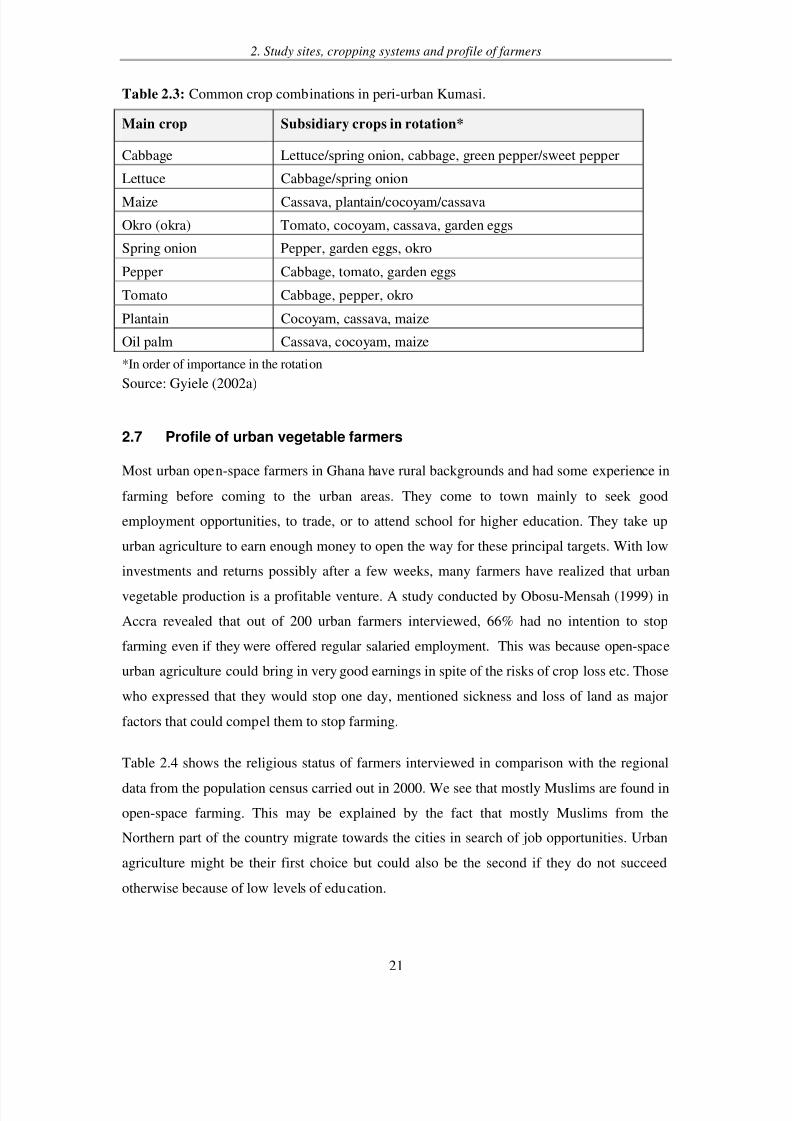
Table 2.3 shows the most common peri-urban crop combinations within a given year. Crop
rotation is carried out depending on the demand for a particular product and as a strategy to
control pests and diseases.
Though vegetable farming continues in the urban areas in the rainy seasons, in many farming
sites, farmers also cultivate some maize, yam etc., alongside, which are used for subsistence.
In marshy areas the parallel crops are sugarcane and cocoyam. During the rainy season, only a
minority of peri-urban farmers shifts to year-round vegetable farming (e.g. tomatoes in theAkumadan area). There are three reasons for this: the importance of maize and cassava for
home consumption (mentioned by 52% of the farmers interviewed); the lower price of
vegetables in the rainy season (40%); and the increased risk of pest attacks (8%).
8/2/2019 Vegetation _ Ghana
http://slidepdf.com/reader/full/vegetation-ghana 17/21
2. Study sites, cropping systems and profile of farmers
21
Table 2.3: Common crop combinations in peri-urban Kumasi.
Main crop Subsidiary crops in rotation*
Cabbage Lettuce/spring onion, cabbage, green pepper/sweet pepper
Lettuce Cabbage/spring onion
Maize Cassava, plantain/cocoyam/cassava
Okro (okra) Tomato, cocoyam, cassava, garden eggs
Spring onion Pepper, garden eggs, okro
Pepper Cabbage, tomato, garden eggs
Tomato Cabbage, pepper, okro
Plantain Cocoyam, cassava, maize
Oil palm Cassava, cocoyam, maize
*In order of importance in the rotation
Source: Gyiele (2002a)
2.7 Profile of urban vegetable farmers
Most urban open-space farmers in Ghana have rural backgrounds and had some experience in
farming before coming to the urban areas. They come to town mainly to seek good
employment opportunities, to trade, or to attend school for higher education. They take up
urban agriculture to earn enough money to open the way for these principal targets. With low
investments and returns possibly after a few weeks, many farmers have realized that urban
vegetable production is a profitable venture. A study conducted by Obosu-Mensah (1999) in
Accra revealed that out of 200 urban farmers interviewed, 66% had no intention to stop
farming even if they were offered regular salaried employment. This was because open-space
urban agriculture could bring in very good earnings in spite of the risks of crop loss etc. Those
who expressed that they would stop one day, mentioned sickness and loss of land as major
factors that could compel them to stop farming.
Table 2.4 shows the religious status of farmers interviewed in comparison with the regional
data from the population census carried out in 2000. We see that mostly Muslims are found in
open-space farming. This may be explained by the fact that mostly Muslims from the
Northern part of the country migrate towards the cities in search of job opportunities. Urban
agriculture might be their first choice but could also be the second if they do not succeed
otherwise because of low levels of education.

8/2/2019 Vegetation _ Ghana
http://slidepdf.com/reader/full/vegetation-ghana 18/21
2. Study sites, cropping systems and profile of farmers
22
Table 2.4: Religious status of urban farmers compare to the regional average
Religious
affiliation
Northern
Region
(%)
Farmers
in Tamale
(%)
Greater
Accra Region
(%)
Farmers
in Accra
(%)
Ashanti
Region
(%)
Farmers in
Kumasi
(%)
Christians 19 13 83 30 78 61
Moslems 56 86 10 67 13 37
Others 25 1 7 3 9 2
Sources: IWMI, unpubl.
A random sample of farmers from the three cities showed that 50-80% were between 20 and
40 years of age (Table 2.5). This group represents those in the working class who migrate to
cities to look for jobs and end up in farming to either supplement their income or because they
failed to get paid jobs. Accra had the highest percentage of farmers over 40 years.
Table 2.5: Age distribution of farmers in the cities
Kumasi Accra Tamale
Age Frequency % Frequency % Frequency %
Below 20 4 4 7 5 1 1
20-30 33 33 45 33 19 25
31-40 35 35 30 21 41 54
Above 40 28 28 56 41 15 20
Sources: IWMI, unpubl.
Gender and household size. Open space irrigated urban vegetable farming in Ghana is
predominantly male dominated (Chapter 3). On the average, only less than 10% of all urban
open-space farmers were women and many of them cultivate indigenous vegetables. This
concurs with earlier findings (e.g. Obosu-Mensah 1999, Gbireh 1999, Armar-Klemesu and
Maxwell, 1998). In all the cities, more than a half of the farmers are married and occasionally
involve their wives in the marketing of produce. In contrast to farming, women dominate
vegetable marketing, especially retail. Chapter 3 will have a special look at gender issues.
8/2/2019 Vegetation _ Ghana
http://slidepdf.com/reader/full/vegetation-ghana 19/21
2. Study sites, cropping systems and profile of farmers
23
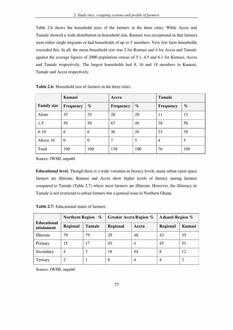
Table 2.6 shows the household sizes of the farmers in the three cities. While Accra and
Tamale showed a wide distribution in household size, Kumasi was exceptional in that farmers
were either single migrants or had households of up to 5 members. Very few farm households
exceeded this. In all, the mean household size was 2 for Kumasi and 4 for Accra and Tamale
against the average figures of 2000 population census of 5.1, 4.5 and 6.1 for Kumasi, Accraand Tamale respectively. The largest households had 8, 16 and 18 members in Kumasi,
Tamale and Accra respectively.
Table 2.6: Household size of farmers in the three cities
Kumasi Accra Tamale
Family size Frequency % Frequency % Frequency %
Alone 35 35 28 20 11 15
1-5 59 59 67 49 38 50
6-10 6 6 36 26 23 30
Above 10 0 0 7 5 4 5
Total 100 100 138 100 76 100
Source: IWMI, unpubl.
Educational level. Though there is a wide variation in literacy levels, many urban open-space
farmers are illiterate. Kumasi and Accra show higher levels of literacy among farmers
compared to Tamale (Table 2.7) where most farmers are illiterate. However, the illiteracy in
Tamale is not restricted to urban farmers but a general issue in Northern Ghana.
Table 2.7: Educational status of farmers
Northern Region % Greater Accra Region % Ashanti Region %
Educational
attainment Regional Tamale Regional Accra Regional Kumasi
Illiterate 79 79 29 48 43 35
Primary 15 17 45 4 45 51
Secondary 4 3 18 44 8 12
Tertiary 2 1 8 4 4 2
Source: IWMI, unpubl.

8/2/2019 Vegetation _ Ghana
http://slidepdf.com/reader/full/vegetation-ghana 20/21
2. Study sites, cropping systems and profile of farmers
24
Cash investment
4%
Food 1%Cash and food
2%
Extra income
33%
Main income
60%
These findings should not be extrapolated to urban agriculture in general. Backyard gardens,
for example, can be found in all parts of the society.
Economic profile. Urban farming provides employment and income for a chain of
beneficiaries, such as farmers, market sellers, suppliers of agricultural input, etc. and therefore
contributes to the national economy, also in Ghana (Obosu-Mensah, 1999, Danso et al.,
2002a, Drechsel et al., 2006a; see Chapter 4). Out of 138 farmers interviewed in Accra, about
60% totally rely on irrigated vegetable cultivation as their only source of income, while 33%
do it as a supplementary source of income. In Tamale, with more seasonal vegetable
production, majority of vegetable producers use it to supplement their incomes from staple
crop farming. Only a minority of open-space cultivators uses urban vegetable farming as a
one-off means of getting money for a later investment or as source of food (Figure 2.8). In
general, farmers of exotic vegetables do not consume their own produce.
Figure 2.8: Main objectives of farmers cultivating vegetables in Urban Accra
Among those for whom farming was a secondary activity in Accra, watchmen/security guards
were predominant (57%) while others were masons, painters, mechanics or cleaners. The case
of Kumasi is similar to that of Accra.
8/2/2019 Vegetation _ Ghana
http://slidepdf.com/reader/full/vegetation-ghana 21/21
2. Study sites, cropping systems and profile of farmers
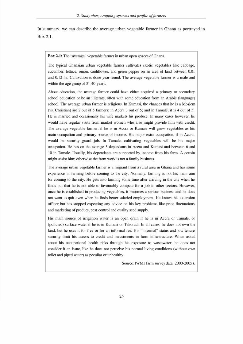
In summary, we can describe the average urban vegetable farmer in Ghana as portrayed in
Box 2.1.
Box 2.1: The “average” vegetable farmer in urban open spaces of Ghana.
The typical Ghanaian urban vegetable farmer cultivates exotic vegetables like cabbage,
cucumber, lettuce, onion, cauliflower, and green pepper on an area of land between 0.01
and 0.12 ha. Cultivation is done year-round. The average vegetable farmer is a male and
within the age group of 31-40 years.
About education, the average farmer could have either acquired a primary or secondary
school education or be an illiterate, often with some education from an Arabic (language)
school. The average urban farmer is religious. In Kumasi, the chances that he is a Moslem
(vs. Christian) are 2 out of 5 farmers; in Accra 3 out of 5; and in Tamale, it is 4 out of 5.
He is married and occasionally his wife markets his produce. In many cases however, he
would have regular visits from market women who also might provide him with credit.
The average vegetable farmer, if he is in Accra or Kumasi will grow vegetables as his
main occupation and primary source of income. His major extra occupation, if in Accra,
would be security guard job. In Tamale, cultivating vegetables will be his major
occupation. He has on the average 5 dependants in Accra and Kumasi and between 6 and
10 in Tamale. Usually, his dependants are supported by income from his farm. A cousin
might assist him; otherwise the farm work is not a family business.
The average urban vegetable farmer is a migrant from a rural area in Ghana and has some
experience in farming before coming to the city. Normally, farming is not his main aim
for coming to the city. He gets into farming some time after arriving in the city when hefinds out that he is not able to favourably compete for a job in other sectors. However,
once he is established in producing vegetables, it becomes a serious business and he does
not want to quit even when he finds better salaried employment. He knows his extension
officer but has stopped expecting any advice on his key problems like price fluctuations
and marketing of produce, pest control and quality seed supply.
His main source of irrigation water is an open drain if he is in Accra or Tamale, or
(polluted) surface water if he is in Kumasi or Takoradi. In all cases, he does not own the
land, but he uses it for free or for an informal fee. His “informal” status and low tenure
security limit his access to credit and investments in farm infrastructure. When asked
about his occupational health risks through his exposure to wastewater, he does not
consider it an issue, like he does not perceive his normal living conditions (without own
toilet and piped water) as peculiar or unhealthy.
Source: IWMI farm survey data (2000-2005).