vinh thanh phu my dinh binh damopen_jicareport.jica.go.jp/pdf/11740693_10.pdfphu my phu cat tay son...
TRANSCRIPT

PHU MY
PHU CAT
TAY SON
AN NHON TUY PHUOC
QUY NHON
VAN CANH
HRO
DONG XUAN KHANH HOA
m
Hoi Son Dam
N
Dinh Binh Dam
VINH THANH
Thi NaiSwamp
C o d e S c h e m e N a m e C o d e S c h e m e N a m eA 1 C a y G a i L e f t B 1 6 V a n P h o n g P r o p e rA 2 C a y K L e f t D 1 0 H u u G ia n gA 3 C a y K e r ig h t n o r t h D 4 B in h H o aA 4 V a n P h o n g t o L a T in h D 6 B in h K h eB 1 H o i S o n U p s t r e a m D 1 3 H o c L a cB 2 C a y G a i R ig h t G 5 V In h T h a n hB 3 C a y K e R ig h t S o u t h E 7 H a T h a n h E x t e n s io n
0 25km155 10 20
B16
B2
C3
B12
C1
C2
C4
C5L
C7C8
C9
C10C11
C12
C13
C14 C15C16C17
C18 C19
C22
C23
C24C25 C26
D14D13
D12
D15D10
G5
E7E7
A4
A1
A2
A3
B3
B1
B13B14
C21
C5R
Code Scheme Name Code Scheme NameA1 Cay Gai Left B16 Van Phong ProperA2 Cay Ke Left D10 Huu GiangA3 Cay Ke right north D4 Binh HoaA4 Van Phong to La Tinh D6 Binh KheB1 Hoi Son Upstream D13 Hoc LacB2 Cay Gai Right G5 VInh ThanhB3 Cay Ke Right South E7 Ha Thanh Extension-> Tan An - Dap Da Schemes are to be referred to Figure 13.4
< Legend >
RiverRoadExisting Irri.SchemesIrri.Schemes withproposed integrationPlanned Irri.SchemesExisting DamPlanned DamPlanned Irr.CanalCatchment AreaExisting Irri.AreaNew Projectswith Dinh Binh DamMixed Area (VanPhong & Hoi Son)
LF-9
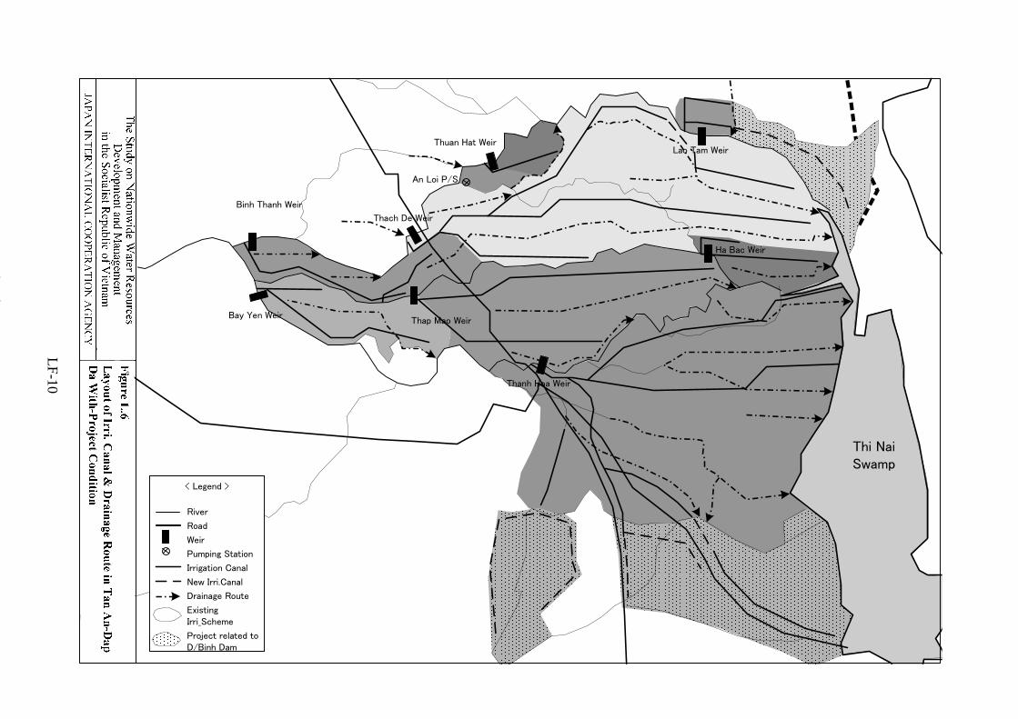
LF-10

AN NHON
TUY PHUOC
QUY NHON
Binh Thanh Weir
Bay Yen WeirThap Mao Weir
Thach De Weir
Lao Tam Weir
Ha Bac Weir
Thuan Hat Weir
Thanh Hoa Weir
Da Mai Dam
C11
C10
B13
C19
C4
C24C25
C26
C1
C2
C3
C5
C13
C7
C8
C9
C14
C15
C16
C17
C22C23
Thi NaiSwamp
C5
< Legend >
RiverRoadExisting Irri.SchemesIrr.Schemes withproposed integrationIrrigation CanalWeirPumping Station
N
Code Scheme Name Code Scheme Name Code Scheme NameC1 Thanh Hoa C10 Bay Yen C19 Thanh DanhC2 Thach De C11 Binh Thanh C21 Thach DeC3 Thuan Hat C13 Dap Cat C22 An LoiC4 Thap Mao C14 Van Kham C23 Trung LyC5 Lao Tam C15 Van Moi C24 An HoaC7 Bo Ngo C16 Nhon Phong C25 An Thuan I+IIC8 Nha Phu C17 Da Den C26 Long QuangC9 Ha Bac C18 Ben TranhNote: C20 is supplementary for B13
0 31 2 5 km4
C20(Included in B13)
C18
Dap Cat Weir
Nha Phu Weir
Nhon Phong Weir
Da Den Weir
LF-11

Figure L.8 Construction Time Schedule for Van Phong Weir and Irrigation and Drainage System
LF-12

N1 Van Phong Ext (La Tinh)
VP-N1 7901.280
10,294 8,808 8,499 7,870 7,598 7,411 3,32416.677 14.269 13.768 12.750 12.308 12.006 5.385
188 VP-N18 VP-N20 VP-N22 VP-N24 VP-N26 VP-N28 290 VP-N300.304 0.469
495 VP-N16 118 VP-N320.802 0.191
1,003 VP-N14 447 VP-N341.626 0.724
477 VP-N12 136 VP-N360.774 0.220
161 VP-N10 79 VP-N380.260 0.129
236 VP-N8 81 VP-N400.382 0.131
244 VP-N6 160 VP-N420.395 0.260
105 VP-N4 205 VP-N440.170 0.333
VP-N4660 VP-N20.098
Kone River
Van Phong Weir
3,2975.341
1310.212
120 117
690.112
4,087
0.943
0.115
77
610.098
840.136
0.570
2120.343
71
710.115
1020.166
450.074
1550.251
1.367
1,8663.022
1,5182.460
1,4392.331
1,3582.200
1,127
8440.125
2,782
2,6644.316
4.507
1.825
2520.409
352
13,78122.326
22.15513,676
13,17221.339
13,57121.985
12,63120.463
12,85320.821
12,08319.574
1530.247
460.075
1,486 1792.407 0.289 0.195 0.190
6.621
582
10,58417.147
11,07917.949
Figure L.9 (1/6)
The Study on Nationw
ide Water R
esourcesD
evelopment and M
anagement
in the Socialist Republic of V
ietnamJA
PAN
INTER
NA
TION
AL C
OO
PERA
TION
AG
ENC
YIrrigation D
iagram of V
an Phong Proper
New canal
A Net Irrigation Area (ha)
Q Design Discharge (m3/s)
New Weir
BP of Branching River
Primary and Secondary
Irrigation canal
On-farm Irrigation canal
Extension Area
<Legend>
The Study on Nationw
ide Water R
esources
New canal
A Net Irrigation Area (ha)
Q Design Discharge (m3/s)
New Weir
BP of Branching River
Primary and Secondary
Irrigation canal
On-farm Irrigation canal
Extension Area
<Legend>
LF-13

CGL-N1
Cay Ke Weir
La Tinh River
Cay Gai Weir
CGR-N3 CGR-N5 CGR-N7
0 CKR-N1
CGR-N2 CGR-N4 CGR-N8
1,061
1.719
382
0.619
527827
1.340
214
0.347
0.993
100
0.162
400
0.648
2,208
3.577
375
0.608
476
0.771
427
0.692
727
1.178
2,684
4.348
613
100
0.162
100
0.162
200
0.324
0.854
3,297
5.341
0.130
70
0.113
Van
Phon
g N
1 C
anal
150
80
514
0.833
434
0.703
364
0.590
757
1.226
476
0.771
526
0.455
La Tinh River
2.529
1,561
118
0.191
0.316
281
0.243
195
0.536
331
0.852
Figure L.9 (2/6)
The Study on Nationw
ide Water R
esourcesD
evelopment and M
anagement
in the Socialist Republic of V
ietnamJA
PAN
INTER
NA
TION
AL C
OO
PERA
TION
AG
ENC
YIrrigation D
iagram of L
a Tinh A
rea
New canal
Existing canal
A Net Irrigation Area (ha)
Q Design Discharge (m3/s)
Existing Weir
Siphon
Pumping Station
BP of Branching River
Primary and Secondary
Irrigation canal
On-farm Irrigation canal
Extension Area
<Legend>
New canal
Existing canal
A Net Irrigation Area (ha)
Q Design Discharge (m3/s)
Existing Weir
Siphon
Pumping Station
BP of Branching River
Primary and Secondary
Irrigation canal
On-farm Irrigation canal
Extension Area
<Legend>
LF-14

LT-N1
TL-N2
NC-MC TDp-MC
Dap Da River
Binh Thanh Weir Thach De Weir THA-MC
AL-MC Lao Tam Weir
BT-N1
TD-N2
TD-N1
182
0.295
3,804
6.162
1,590
2.576
342
0.554
0.794
490
79
0.128
1,382
2.239
2,080
3.370
0.829
751
1.217
0.303
18743
0.070
261
60
0.097
67
0.109
0.423
Thi Nai Sw
amp
193
0.313
33
0.053
226
0.366
239
0.387
512
Figure L.9 (3/6)
The Study on Nationw
ide Water R
esourcesD
evelopment and M
anagement
in the Socialist Republic of V
ietnamJA
PAN
INTER
NA
TION
AL C
OO
PERA
TION
AG
ENC
YIrrigation D
iagram of D
ap Da R
iver Area
Existing canal
Pumping Station
A Net Irrigation Area (ha)
Q Design Discharge (m3/s)
New Weir
BP of Branching Canal
Primary and Secondary
irrigation canal
On-farm Irrigation canal
<Legend>
LF-15

HB-N1
TM-N1 Thap Mao Weir Ha Bac Weir HB-N2
Go Cham RiverTM-MC
TM-N2
TM-N3
TM-N3
Thi Nai Sw
amp
0.243
0.319
150
197
0.136
37
0.060
1.048
647
300
0.486
132
0.214
84
0.486
300
1,018
1.649
235
0.381
1,665
2.697
47
0.076
253
0.410
Figure L.9 (4/6)
The Study on Nationw
ide Water R
esourcesD
evelopment and M
anagement
in the Socialist Republic of V
ietnamJA
PAN
INTER
NA
TION
AL C
OO
PERA
TION
AG
ENC
YIrrigation D
iagram of G
o Cham
River A
rea
Existing canal
A Net Irrigation Area (ha)
Q Design Discharge (m3/s)
Existing Weir
BP of Branching Canal
Primary and Secondary
Irrigation canal
On-Farm Irrigation canal
<Legend>
Existing canal
A Net Irrigation Area (ha)
Q Design Discharge (m3/s)
Existing Weir
BP of Branching Canal
Primary and Secondary
Irrigation canal
On-Farm Irrigation canal
<Legend>
LF-16

BY-N1
EP
Bay Yen Weir
Thanh Hoa I Weir BY-N2
Tan An RiverThanh Hoa II Weir
TH-N1
TH-N3
TH-N4
TH-N2
868
1.406
1,705
1.374
461
0.747
3,483
5.642
0.182
TH2-
N1
TH-N
2.2
0.804
496
2,211
0.177 1.401
3.581 1.199
740
2.003
1,236
5,806
109
0.296
9.406
169
0.274
183 Thi Nai Sw
amp
865
30
0.049
352
0.570
2,573
4.168
910
Tan An R
iver
382
0.619
387
0.627
848
112
1.474
1.150
0.324
200
710
The Study on Nationw
ide Water R
esourcesD
evelopment and M
anagement
in the Socialist Republic of V
ietnamJA
PAN
INTER
NA
TION
AL C
OO
PERA
TION
AG
ENC
Y
Existing canal
Pumping Station
A Net Irrigation Area (ha)
Q Design Discharge (m3/s)
Existing Weir
BP of Branching Canal
Primary and Secondary
irrigation canal
On Farm Irrigation canal
Extension Area
<Legend>
Figure L.9 (5/6)
Irrigation Diagram
of Tan A
n &H
a Thanh L
ower
Area
Existing canal
Pumping Station
A Net Irrigation Area (ha)
Q Design Discharge (m3/s)
Existing Weir
BP of Branching Canal
Primary and Secondary
irrigation canal
On Farm Irrigation canal
Extension Area
<Legend>
LF-17

Dinh Binh Dam
Kone River
VT-N1
VT-N3
VT-N5
VT-N7
VT-N9
VT-N11
VT-N13
VT-N15HUG_MC
HNG_MC
Kone River
HOG_MC BH_MC BK_MC HL_MC
0.243
250.040
Kon
e R
iver
1501,3192.137
3530.572
308
3840.622
400.065
0.08653
0.219135
1.395
0.2011241,017
580.094
0.05132
1.648
861
350.057
0.14086
0.04025
0.188116
6871.113
6231.009
2900.471
1790.291
1440.234
1330.216
400.064
1040.168
0.499
110.018
1760.285
3510.569
Figure L.9 (6/6)The Study on Nationwide Water Resources
Development and Managementin the Socialist Republic of Vietnam
JAPAN INTERNATIONAL COOPERATION AGENCY Irrigation Diagram of Vinh Thanh Area
New canal
Pumping Station
A Net Irrigation Area (ha)
Q Design Discharge (m3/s)
New Dam
BP of Branching Canal
Primary and Secondary
irrigation canal
On-farm Irrigation canal
<Legend>
LF-18

LF-19

LF-20