case study: mapping potential informal settlements areas
TRANSCRIPT
Case study: Mapping potential informal settlements areas inTegucigalpa with machine learning to plan ground survey
Federico BayleDymaxion Labs
Buenos Aires, [email protected]
Damian E. SilvaniDymaxion Labs
Buenos Aires, [email protected]
ABSTRACTData collection through censuses is conducted every 10 years onaverage in Latin America, making difficult monitoring the growthand support needed by communities living in informal settlements.Conducting a field survey requires logistical resources to be able todo it exhaustively. The increasing availability of spatial open-data,high-resolution satellite images, and open-source tools, allow usto train machine learning algorithms map these areas in differentcities of Latin America. This case study shows the collaborationbetween Dymaxion Labs and the NGO Techo to employ that tech-niques to create the first informal settlements census of Tegucigalpa,Honduras.
KEYWORDSNeural networks, informal settlements, transfer learning, GIS.ACM Reference Format:Federico Bayle and Damian E. Silvani. 2020. Case study: Mapping potentialinformal settlements areas in Tegucigalpa with machine learning to planground survey. In KDD Humanitarian Mapping Wokshop ’20: ACM SIGKDDConference on Knowledge Discovery and Data Mining August 24, 2020; SanDiego, California USA. ACM, New York, NY, USA, 4 pages.
1 INTRODUCTIONPoverty is a major issue in Latin America. Slums and informal set-tlements grow quickly, and there is a need for more up-to-date datafor policymaker decisions. If governments had updated informationabout slums and their growth, they could give the affected familiesbetter life conditions and change their future. Having updated in-formation helps to improve health, education, and security for thechildren who currently live there. In order to carry out an accuratesurvey of informal areas, exhaustive coverage of the territory isrequired. This task requires having costly logistical and materialresources, which in turn undermines periodicity and scope.
These settlements often do not have critical public services suchas sanitation, resulting in health and environmental hazards, espe-cially for children.
Tegucigalpa (formally Tegucigalpa, Municipality of the CentralDistrict) is Honduras’ largest and most populous city as well as thenation’s political and administrative center. The urban populationPermission to make digital or hard copies of all or part of this work for personal orclassroom use is granted without fee provided that copies are not made or distributedfor profit or commercial advantage and that copies bear this notice and the full citationon the first page. Copyrights for components of this work owned by others than ACMmust be honored. Abstracting with credit is permitted. To copy otherwise, or republish,to post on servers or to redistribute to lists, requires prior specific permission and/or afee. Request permissions from [email protected] Humanitarian Mapping Workshop ’20, August 24, 2020, San Diego, California USA© 2020 Association for Computing Machinery.
is estimated to 1,143,373 inhabitants by 2019. The urban area is201.5 square kilometers. There no significant progress has beenseen in this matter in recent decades about informal settlements lifeconditions. The data required to formulate public policies aimedat improving the situation of informal settlements population, isalmost non-existent through official and unofficial sources in Hon-duras.
For this reason, the NGO TECHO1 planned to conduct in 2018 acensus of informal settlements in the urban district of the CentralDistrict, aiming to provide clear, reliable and public informationon the current problem of thousands of people living in poverty.TECHO is a youth-led non-profit organization founded in 1997 witha presence in Latin America and the Caribbean. They seek to builda fair, integrated, and poverty-free society, where everyone has theopportunities needed to develop their capacities and fully exercisetheir rights.
Due to the lack of the previous census and public data aboutinformal settlements in Tegucigalpa, in Dymaxion Labs2 we part-nered with TECHO to help them map the potential areas to survey.The main objective was to reduce the survey area to be scoutedby the volunteer team. Based on our previous work on informalsettlements mapping in Buenos Aires (Argentina) and AsunciÃşn(Paraguay), the machine learning algorithm AP-LATAM[8] lookedpromising to apply in Honduras based on a previous survey ofGuatemala City (Guatemala). Dymaxion Labs is a startup devel-oping a cloud-based API to detect objects in satellite imagery atscale.
2 RELATEDWORKFollowing Kuffer, Pfeffer, and Sliuzas (2016)[7], at least 87 paperswere published in English about this topic. Reviewing some ofthem, we can find studies for Argentina, Colombia, England, Ghana,Nigeria, Tanzania, Uganda, Malawi, and Rwanda.
Focusing on Latin American cities, Hall, Malcolm, and Piwowar(2001)[4] used Landsat and Radarsat imagery combined with GISdata to detect urban poverty pockets in Rosario, Argentina. PatiÃśoand Duque (2013)[10] used very high-resolution images to estimatea slum index on MedellÃŋn, Colombia.
For other cities around the world, Stoler et. al. (2012)[11] andWeeks et.al (2007)[12] used very high-resolution imagery for Ac-cra (Ghana) deriving features based on texture and land coverto estimate a slums distribution index. Arribas-Bel, PatiÃśo, andDuque (2017)[1] employed a similar approach to estimate the Liv-ing Environment Deprivation index for small areas in Liverpool,England. Jean et. al. (2016)[6] used nighttime imagery with very1www.techo.org2www.dymaxionlabs.com
arX
iv:2
006.
1449
0v1
[cs
.CY
] 2
5 Ju
n 20
20
KDD Humanitarian Mapping Workshop ’20, August 24, 2020, San Diego, California USA Bayle and Silvani
high-resolution daily imagery to estimate variation in local-leveleconomic outcomes for Nigeria, Tanzania, Uganda, Malawi, andRwanda. They employed transfer learning of trained convolutionalneural networks, a technique we applied in this case study as well.
3 METHODOLOGYThe open-source algorithm AP-LATAM, tries to reduce survey costsby analyzing high-resolution satellite imagery to detect potentialareas of informal settlement growth. The final result is a geospatialdataset of areas that could contain informal settlements. By havingupdated potential slums growth locations, decision makers canprioritize the areas to survey.
Source code for building and using a classifier to create datasetshas also been released as open-source in a GitHub repository3with a BSD-2 license. Instructions on how to train the classifierand predicting over new images are available there. This includesnot only the steps for training the model but also the neural netweights for using with new satellite imagery. AP-LATAM is partof the Inter-American Development Bank’s Code for Developmentplatform4.
This tool is already calibrated to detect slums and informal set-tlements in Buenos Aires, AsunciÃşn, and Montevideo. To obtainthose results, Dymaxion Labs applied computer vision and deeplearning algorithms to satellite imagery and other georeferenceddata. Slum patterns such as texture and morphology of roofs aredetected. From Dymaxion Labs experience calibrating these kindsof algorithms, such patterns have strong local dependencies. AsTECHO has ground truth polygons and imagery from a previoussurvey in Guatemala City (Guatemala) in 2016, the strategy wasbased on training AP-LATAM on these data and then mappingpotential informal settlements areas on Tegucigalpa (Honduras).Guatemala City is the capital and largest city of Guatemala, a coun-try that borders with Honduras. It has 2,750,965 inhabitants withan area of 220 square kilometers. Taking into account the TECHO’ssurvey database and the similarity of the geography of these cities,it was the best candidate to train AP-LATAM to map Tegucigalpa.
The method consists of a binary classifier of image tiles of high-resolution sub-meter satellite imagery. Each image is classified aswhether it contains an informal settlement or not. Some examplesof these tiles area showed in figure 1
To build the dataset for training and validation, the classifiertakes a vector file of polygons of previously-known informal set-tlements and takes fixed-size tiles of images by sliding a windowacross the entire satellite image. For each image tile, it checks if thetile intersects with any polygon and tags it appropriately.
To make predictions over new images, it slides a window overthe new image and builds a new vector file of polygons of the sizeof each positively-tagged image tile. The resulting dataset is post-processed to remove polygons with small probability and dissolvethem into bigger polygons.
In our tests with Guatemala, as a final post-processing step,we used OpenStreetMap[9] datasets and crossed them with thepolygons file.
3https://github.com/dymaxionlabs/ap-latam4https://code.iadb.org/en/repository/60/ap-latam
3.1 Imbalanced classesA binary classifier of informal settlements has imbalanced classes,that is, images tagged as positive (areas that contain settlements)are much less frequent than images tagged as negative (areas thatdo not contain settlements). To decrease bias and avoid overfitting,we under-sampled the negatives by taking a set of images of sizeproportional to the size of positives. We tried undersampling witha proportion of 4 and 8 and settled with 4.
3.2 Data augmentationTo help prevent overfitting and make the model generalize better,we perform data augmentation on the image tiles. We only appliedhorizontal and vertical flipping, but there are other random trans-formations that we could use to augment our dataset, like hue andbrightness randomization (to account for differences in atmospherecorrections) and rotations.
3.3 Fine-tuningA large amount of data is needed to build a functional convolutionalneural network model. In practice, it is common to reuse a pre-trained network. However, most pre-trained networks work for adifferent set of labels and were not trained with satellite images, sofor this use case it is necessary to retrain some of the top layers toimprove prediction.
The methodology used here was to fine-tune a ResNet-50[5]network with our satellite imagery. We chose this architecturetaking into account the trade-off between precision and hardwarerequirements to perform experiments. The procedure is roughly asfollows:
(1) Instantiate the convolutional base of ResNet-50.(2) Add a fully-connected model on top, with a standard SGD
optimizer and configure a binary cross-entropy loss function.(3) Freeze the layers of the model up to the top 70 layers.(4) Retrain the model.The Keras library was used for data augmentation, training, and
prediction[2].
3.4 Post-processingThe resulting dataset after prediction over sliding windows is a setof small fixed-size squares, with a prediction probability associated.To refine the results we apply the following:
(1) Median filter: remove squares with low probability and asmall number of neighbors.
(2) Dissolve overlapping squares: if the sliding window stepsize is smaller than the size of the windows, it may end upwith overlapping squares, so this step dissolves them into asingle polygon with mean probability values between thevalues of each connected squares.
As mentioned before, we also used a dataset of blocks and cal-culated the intersection between the squares and blocks, and ifsufficient squares covered a block, we picked them to form a newdataset of blocks that contain potential informal settlements. Theoutcome has better prediction accuracy mainly because roads andother areas are not considered.

Mapping potential informal settlements in Tegucigalpa with ML KDD Humanitarian Mapping Workshop ’20, August 24, 2020, San Diego, California USA
(a) Tiles tagged as true (b) Tiles tagged as false
Figure 1: Example of images tiles tagged as either true or false, whether they contain a informal settlement or not.
4 RESULTSThe resultant methodology had a Cohen’s Kappa[3] index of 0.82 atpixel level on Guatemala validation polygons. Based on the previ-ous work done between both organizations analyzing the cities ofBuenos Aires (Argentina), AsunciÃşn (Paraguay) and Montevideo(Uruguay), imagery from those countries were added to the train-ing dataset. Due to the different geography, like the soil color inAsunciÃşn, and the common used materials for construction, thebest results were achieved using only Guatemala data.
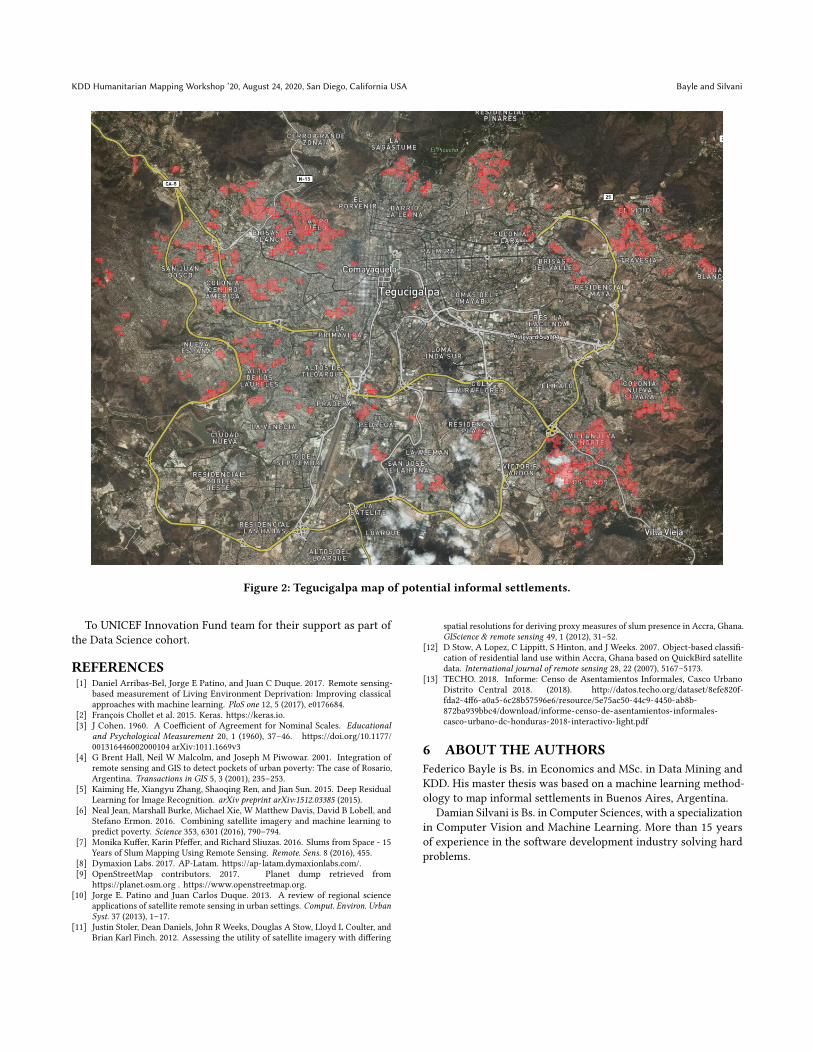
After being trained with the entire city, we applied it on theTegucigalpa imagery to generate the map of potential areas forsurveying. This map (figure 2) was uploaded to our website (bothas downloadable data and the online map). These datasets havebeen released as public domain data, using the same license5 thatOpenStreetMap uses for its data, the Open Data Commons PublicDomain Dedication and License. From the AP-Latam website theuser can download the datasets as GeoJSON files, one for each areaand image acquisition date. The user can also explore an onlinemap with the latest dataset generated.
Combining this map and other data sources from a utility com-pany and government agencies, TECHO planned the fieldwork intwo stages: territory exploration and surveyors training. To startthe survey in one of the most violent cities in Latin America, a strictsecurity protocol was designed. One of the protocols taken for thesafety of the volunteers on the ground suggested not to surveyan informal settlement without having previously contacted localreferents that would allow them to guarantee minimum security.The search for local referents was carried out throughout the field-work. TECHO also used the potential informal settlements map todouble-check the delimitation of the most hazardous places in thecity to avoid sending volunteers to survey those areas.
5https://opendatacommons.org/licenses/pddl/1-0/
5 CONCLUSIONSThe application of the transfer learning methodology trained inGuatemala City to map potential informal settlements in Teguci-galpa collaborates with TECHO’s plan to survey the entire city. Inparticular, it helps them to map informal settlements located indangerous areas where volunteers are not allowed to survey.
The 2018 Informal Settlements Census[13] finally took placein the Metropolitan Area of the Central District (D.C.), specifi-cally in the urban area, made up of the cities of Tegucigalpa andComayaguela. The objective was to visit 796 neighborhoods andresidential areas that make up the urban area, with the aim ofidentifying informal settlements and subsequently characterizingand georeferencing each one of them. The results were released asopen data6. 40% of the territory where informal settlements withoutproperty titles are located belong to the state. Thereby, this mapcan be used by policymakers to relocate people living in risky areasimmediately.
After the execution, 161 informal settlements were identified, 124settlement files were raised with the help of references in informalsettlements, and it was estimated that there are 42,000 familiesliving in this situation.
From a replication perspective, having a technical team is criticalnot only for training and applying the algorithm, but also to helpvalidate the mapping results. With more frequent ground valida-tions, more iterations could be made on the algorithm to get a betteraccuracy in the final map. The technical skills and GIS knowledgeof TECHO’s team proved to be vital in achieving the quality level ofground surveys. In terms of mapping new cities, the availability ofup-to-date high-resolution imagery is also essential to get relevantresults.
ACKNOWLEDGMENTSTo MarÃŋa JesÞs Silva Rozas and Rubens C. Schrunder for givingus the chance to apply our methodology in a real-world case andvalidate the results in Honduras.6http://datos.techo.org/en/dataset/honduras-censo-de-asentamientos-informales-casco-urbano-distrito-central
KDD Humanitarian Mapping Workshop ’20, August 24, 2020, San Diego, California USA Bayle and Silvani
Figure 2: Tegucigalpa map of potential informal settlements.
To UNICEF Innovation Fund team for their support as part ofthe Data Science cohort.
REFERENCES[1] Daniel Arribas-Bel, Jorge E Patino, and Juan C Duque. 2017. Remote sensing-
based measurement of Living Environment Deprivation: Improving classicalapproaches with machine learning. PloS one 12, 5 (2017), e0176684.
[2] François Chollet et al. 2015. Keras. https://keras.io.[3] J Cohen. 1960. A Coefficient of Agreement for Nominal Scales. Educational
and Psychological Measurement 20, 1 (1960), 37–46. https://doi.org/10.1177/001316446002000104 arXiv:1011.1669v3
[4] G Brent Hall, Neil W Malcolm, and Joseph M Piwowar. 2001. Integration ofremote sensing and GIS to detect pockets of urban poverty: The case of Rosario,Argentina. Transactions in GIS 5, 3 (2001), 235–253.
[5] Kaiming He, Xiangyu Zhang, Shaoqing Ren, and Jian Sun. 2015. Deep ResidualLearning for Image Recognition. arXiv preprint arXiv:1512.03385 (2015).
[6] Neal Jean, Marshall Burke, Michael Xie, W Matthew Davis, David B Lobell, andStefano Ermon. 2016. Combining satellite imagery and machine learning topredict poverty. Science 353, 6301 (2016), 790–794.
[7] Monika Kuffer, Karin Pfeffer, and Richard Sliuzas. 2016. Slums from Space - 15Years of Slum Mapping Using Remote Sensing. Remote. Sens. 8 (2016), 455.
[8] Dymaxion Labs. 2017. AP-Latam. https://ap-latam.dymaxionlabs.com/.[9] OpenStreetMap contributors. 2017. Planet dump retrieved from
https://planet.osm.org . https://www.openstreetmap.org.[10] Jorge E. Patino and Juan Carlos Duque. 2013. A review of regional science
applications of satellite remote sensing in urban settings. Comput. Environ. UrbanSyst. 37 (2013), 1–17.
[11] Justin Stoler, Dean Daniels, John R Weeks, Douglas A Stow, Lloyd L Coulter, andBrian Karl Finch. 2012. Assessing the utility of satellite imagery with differing
spatial resolutions for deriving proxy measures of slum presence in Accra, Ghana.GIScience & remote sensing 49, 1 (2012), 31–52.
[12] D Stow, A Lopez, C Lippitt, S Hinton, and J Weeks. 2007. Object-based classifi-cation of residential land use within Accra, Ghana based on QuickBird satellitedata. International journal of remote sensing 28, 22 (2007), 5167–5173.
[13] TECHO. 2018. Informe: Censo de Asentamientos Informales, Casco UrbanoDistrito Central 2018. (2018). http://datos.techo.org/dataset/8efe820f-fda2-4ff6-a0a5-6c28b57596e6/resource/5e75ac50-44c9-4450-ab8b-872ba939bbc4/download/informe-censo-de-asentamientos-informales-casco-urbano-dc-honduras-2018-interactivo-light.pdf
6 ABOUT THE AUTHORSFederico Bayle is Bs. in Economics and MSc. in Data Mining andKDD. His master thesis was based on a machine learning method-ology to map informal settlements in Buenos Aires, Argentina.
Damian Silvani is Bs. in Computer Sciences, with a specializationin Computer Vision and Machine Learning. More than 15 yearsof experience in the software development industry solving hardproblems.