exhiit a - florida department of transportation · stage i sos i december 8, 2017 ... (ilc), the...
TRANSCRIPT

EXHIBIT “A”
SCOPE OF SERVICES
FOR
US 27 CORRIDOR STUDY - FROM SR 60 TO LAKE COUNTY LINE
FPID NO: 440320 1 22 01

Stage I SOS i December 8, 2017 FPID No. 440320 1 22 01
Table of Contents
FPID No. 440320 1 22 01
1 CONTRACT PURPOSE:…………………………………………………………………………………………………………………………1
2 CORRIFOR DESCRIPTION:……………………………………………………………………………………………………………………3
3 PROJECT MANAGEMENT PLAN:………………………………………………………………………………………………………….5
4 PHASE I DEFINE THE PROBLEM:……………………………………………………………….............................................6
5 PHASE II DEFINE GUIDING PRINCIPLES………………………………………………………………………………………………12
6 EVALUATION CRITERIA / MEASURES OF SUCCESS……………………………………………………………………………..13
7 PHASE III DEFINE AND SELECT ALTERNATIVES……………………………………………………………………………………15
8 CORRIDOR ALTERNATIVES AND STRATEGIES REPORT………………………………………………………………………..19
Stage I SOS A-1 December 8, 2017 FPID No. 440320 1 22 01
Scope of Services US 27 Corridor Study from SR 60 to Lake County Line
1 CONTRACT PURPOSE The District One US 27 Corridor Alternatives Analysis Study (US 27 CORRIDOR NORTH MOBILITY STUDY) is a contract intended to support and assist the Florida Department of Transportation (FDOT) District One (DEPARTMENT) and its transportation partners define a multimodal program of projects and strategies to improve the mobility, safety, and livability within and served by the US 27 corridor. Projects, strategies, and recommendations developed through this study will maximize the multimodal potential of the US 27 CORRIDOR NORTH required to sustain the economic vitality of the region and protect significant investments being made today. The US 27 CORRIDOR NORTH STUDY will be coordinated with other recent and active planning studies and improvement projects to maximize the DEPARTMENT’S investment as well as ensure consistency in planning and implementation. The US 27 CORRIDOR NORTH MOBILITY STUDY corridor demands accommodations for all transportation users, with a heavy emphasis on freight. This multimodal plan will address congestion and mobility issues within the study area while also guiding the evolution of the corridor through Context-Sensitive Solutions (CSS) contained in a unified plan. Context Sensitive Solutions (CSS) is a process that ensures that transportation projects are designed holistically, directly evaluating impacts to the built and natural environment and providing recommendations that support a community defined vision for the future. This STUDY will be closely coordinated with local and regional agency partners and stakeholders to develop consensus-based recommendations to address the identified needs of current and future users, and to ensure CSS are included in the planning process. The Corridor Planning Study Process to be followed for this STUDY is provided in Figure 1 below. The STUDY will follow a methodology that clearly links planning activities and analyses to the National Environmental Policy Act (NEPA) and Project Development and Environment (PD&E) processes. This planning and environmental linkage (PEL) methodology will address the following goals:
• to define transportation improvement goals and performance metrics that address short‐term and long‐term improvement strategies to the year 2045 consistent with the FDOT Work Program cycle
• to develop an analysis methodology accepted by the DEPARTMENT, local transportation partners, the Federal Highway Administration (FHWA), and other regulatory agencies that incorporates the planning results into the future NEPA documentation
• to document non‐viable alternatives early, and drop these alternatives from further consideration
• to identify projects, programs, and strategies that achieve improvement goals
• to develop a financial feasibility analysis of proposed project alternatives and develop innovative funding scenarios
• to collect data with a longer “shelf life” that can be utilized in future Project Development phases
• to develop viable project phase programming scenario alternatives
• to fully utilize the planning analysis as an integral part of the NEPA process to maximize available resources

Stage I SOS A-2 December 8, 2017 FPID No. 440320 1 22 01
• to achieve early agency consensus on mobility solutions and proposed implementation scenarios
• to establish future level of effort
1.1 FIGURE 1 CORRIDOR PLANNING STUDY PROCESS
The Project Team (TEAM) will support the DEPARTMENT in conducting a coordinated process of quantitative and qualitative data collection to synthesize those data into a catalog of issues and opportunities within the US 27 CORRIDOR NORTH MOBILITY STUDY corridor (Phase 1). The TEAM will assist the DEPARTMENT assemble a Project Advisory Group (PAG) to provide regional guidance to the US 27 CORRIDOR NORTH MOBILITY STUDY. The TEAM will then support the DEPARTMENT and PAG develop the guiding principles, or the vision, and the “Purpose and Need” (Phase 2). In Phase 2, the CONSULTANT will support the DEPARTMENT in clearly defining the rationale for the US 27 CORRIDOR NORTH MOBILITY STUDY (Purpose), but will also establish the severity of the planning problem (Need). Data will be collected throughout the US 27 CORRIDOR NORTH MOBILITY STUDY as identified by the PAG and stakeholders. The planning Purpose and Need statement will form the basis for the more detailed Purpose and Need section required for projects that advance to Project Development and are required to comply with the National Environmental Policy Act (NEPA) / Project Development & Environment (PD&E) process. Phase 2 is also where the Project Advisory Group (PAG) will define the measures of success (MOS): The measures of success are the evaluation criteria that will be used to compare different solutions that will result from the planning study. These measures should be derived directly from the previous two steps- guiding principles, and the purpose and need.
Stage I SOS A-3 December 8, 2017 FPID No. 440320 1 22 01
The MOS developed for this project should span beyond highway capacity performance measures and should reflect holistic, locally-identified “values” such as safety, walkability, economic development potential, environmental preservation, etc. The CONSULTANT will then develop a set of CSS alternative strategies that have the potential to address the needs and issues identified in Phase 2 (Phase 3). During Phase 3, the CONSULTANT will facilitate assessment of these alternatives based on the guiding principles and the planning Purpose and Need identified during Phase 2. Alternatives will be selected by the FDOT and the PAG to be advanced into subsequent Project Development and implementation phases based on sound engineering, environmental, and economic analyses, as well as a consensus-driven application of project goals and community values.
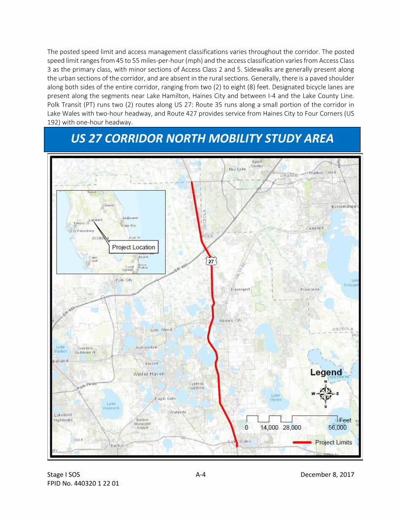
2 CORRIDOR DESCRIPTION The US 27 CORRIDOR NORTH MULTIMODAL MOBILITY STUDY corridor is a 31.97-mile section of US 27 from SR 60 (MP 0.000) to US 192 / Lake County Line (MP 31.970) in Lake County, Florida. See US 27 CORRIDOR NORTH MOBILITY STUDY AREA map below. US 27 is part of the State Intermodal System (SIS), and is a primary north-south route for freight traffic through the state. The Strategic Intermodal System (SIS) is Florida’s high priority network of transportation facilities important to the state’s economy and mobility. The Governor and Legislature established the SIS in 2003 to focus the state’s limited transportation resources on the facilities most significant for interregional, interstate, and international travel. The SIS is the state’s highest priority for transportation capacity investments and a primary focus for implementing the Florida Transportation Plan (FTP), the state’s long-range transportation vision and policy plan. US 27 is characterized by heavy interregional and regional freight movement. US 27 serves as a regional connection for commuter and freight traffic, and is a major arterial for local traffic. As such, the mix of users has a variety of planning needs. US 27 provides key connections to major activity centers such as the Winter Haven / CSX Intermodal Logistics Center (ILC), the Legoland theme park, the Ridge Scenic Highway near Haines City (US 17), Bok Tower Gardens (a scenic destination), and I-4 which is the major east-west corridor in Central Florida. The corridor passes through five (5) municipalities, including Lake Wales, Dundee, Winter Haven, Lake Hamilton, Davenport, and Haines City. The remainder of the corridor is within unincorporated Polk County. The character of US 27 is a mix of urban and rural. The existing roadway is a six (6) lane urban principal arterial, including 12-foot through lanes with a large center median (generally 42-feet wide with grass landscaping), and varying right-of-way. Generally, curb and gutter exists in the urban portions, with open swale drainage in the rural sections. The segment of US 27 from Central Grove Road to US 192 / Lake County Line was recently widened from four (4) lanes to six (6) lanes. The predominant land uses are commercial and industrial, with residential scattered throughout and along the northernmost section of the corridor. Large developments of regional impact (DRI) are located east and west of the corridor, including the Ridgewood Lakes DRI, Victor Posner Center DRI, and the Four Corners DRI near the I-4 and US 17/92 corridors (north of Haines City). According to the FDOT Florida Traffic Online (2016) database, the annual average daily traffic (AADT) ranges from approximately 31,500 (near Lake Wales) to 57,000 (near I-4), with truck traffic percentages that range from approximately seven (7) to 12 percent.
Stage I SOS A-4 December 8, 2017 FPID No. 440320 1 22 01
The posted speed limit and access management classifications varies throughout the corridor. The posted speed limit ranges from 45 to 55 miles-per-hour (mph) and the access classification varies from Access Class 3 as the primary class, with minor sections of Access Class 2 and 5. Sidewalks are generally present along the urban sections of the corridor, and are absent in the rural sections. Generally, there is a paved shoulder along both sides of the entire corridor, ranging from two (2) to eight (8) feet. Designated bicycle lanes are present along the segments near Lake Hamilton, Haines City and between I-4 and the Lake County Line. Polk Transit (PT) runs two (2) routes along US 27: Route 35 runs along a small portion of the corridor in Lake Wales with two-hour headway, and Route 427 provides service from Haines City to Four Corners (US 192) with one-hour headway.
US 27 CORRIDOR NORTH MOBILITY STUDY AREA

Stage I SOS A-5 December 8, 2017 FPID No. 440320 1 22 01
3 PROJECT MANAGEMENT PLAN Successful project management efforts involve the right mix of planning, monitoring, and controlling to ensure the project is completed on time, on budget, and with high quality results. The CONSULTANT shall provide a Project Management Plan (PMP) for management coordination and control to ensure successful and timely completion of the STUDY. At the beginning of work under this contract, the CONSULTANT shall prepare a detailed PMP that includes the following information:
• Project Management Approach
• Project Work Plan / Schedule
• Project Budget
• Project Communications Plan
• Quality Assurance / Quality Control Project Management efforts for complete setup and maintenance, developing monthly progress reports, schedule updates, work effort to develop and execute sub-CONSULTANT agreements etc. Progress reports shall be delivered to the DEPARTMENT in a format as prescribed by the DEPARTMENT and no less than 10 days prior to submission of the corresponding invoice. Judgment on whether work of sufficient quality and quantity has been accomplished will be made by the Project Manager by comparing the reported percent complete against actual work accomplished. Within ten (10) days after the Notice to Proceed, the CONSULTANT shall provide a project schedule to include anticipated timelines for key project elements and target deadlines for deliverables. To assist the DEPARTMENT in coordination with internal staff and project stakeholders, the project schedule should also include relationships / dependencies between key milestones with anticipated durations. The anticipated duration for this Corridor Planning Study is up to 36 months.
3.1 PROGRESS REPORTS AND STATUS UPDATE MEETINGS The CONSULTANT shall submit monthly cost and schedule reports to the FDOT Project Manager (PM) to support project monitoring. The contract budget and schedule shall be regarded as the baseline against which status and progress are measured and reported. The CONSULTANT will use Microsoft Project Manager for preparation of the US 27 CORRIDOR NORTH MOBILITY STUDY schedule. The cost and schedule reports will be organized by study phases, starting with Phase 1. The CONSULTANT and DEPARTMENT PM shall meet at least weekly to review the schedule status, cost, and progress of work, as well as address any unanticipated issues and identify solutions. The CONSULTANT is responsible for preparing, distributing, and keeping a record of all project meeting minutes.
3.2 MILESTONE STATUS PRESENTATIONS / MEETINGS The CONSULTANT shall prepare status presentations and meeting summaries for key project milestone meetings updating the PAG and participating agencies on the status and progress of work. Project milestones will be established for each phase of the US 27 NORTH CORRIDOR MOBILITY STUDY, starting with Phase 1. The CONSULTANT’s key staff shall prepare for, and participate in, these meetings and shall provide meeting documentation such as agendas, presentation materials, and meeting summary notes. Participants are expected to include agency staff and stakeholders previously described, in addition to FDOT units to be engaged in the review of products and at key decision points in the process. The CONSULTANT shall provide technical input, coordination and support for the DEPARTMENT to hold or participate in various meetings, which are anticipated, but not limited to include:
• DEPARTMENT and PAG / Stakeholder Kick-off Meeting

Stage I SOS A-6 December 8, 2017 FPID No. 440320 1 22 01
• Existing Conditions Analysis Review meeting
• Future Conditions Analysis Review meeting
• Regular Update Meetings
• Board Presentations The CONSULTANT and DEPARTMENT PM will develop a list of additional boards and working groups that share interests and stakeholders with the US 27 NORTH CORRIDOR MOBILITY STUDY. At a minimum, the CONSULTANT will be responsible for attending the already established US 27 Working Group Meetings. These meetings are held two (2) times a year, share some common stakeholders as the US 27 NORTH CORRIDOR MOBILITY STUDY, and may provide insight into corridor constraints and opportunities.
3.3 MEETING LOCATIONS With input from the PAG, the CONSULTANT will secure a site to host coordination meetings that are convenient to the sub corridor PAG members and meet American Disability Act (ADA) and DEPARTMENT’s requirements. The CONSULTANT will attend the meetings with an appropriate number of personnel to assist the DEPARTMENT'S Project Manager.
3.4 MEETING SUMMARIES The CONSULTANT will provide summary notes of meetings no later than 5 business days after meetings. The CONSULTANT shall also provide project information, graphics, and other materials generated for major deliverables, public and stakeholder coordination meetings in a suitable format to the DEPARTMENT for posting as requested.
3.5 PROJECT BRANDING Project branding is a small exercise that should be discussed at the kick-off meeting with stakeholder input to brand the US 27 NORTH CORRIDOR MOBILITY STUDY with a unified look to be used throughout the study. Early project branding saves time and expense as well as ensures uniformity in project documentation.
4 PHASE I: DEFINE THE PROBLEM The US 27 NORTH CORRIDOR MOBILITY STUDY represents an opportunity to engage local and regional project stakeholders to identify mobility gaps (the problem), and establish planning goals and values (the vision) that leads to implementation through the development of potential improvement alternatives. Collaboration with the project partners and stakeholders will be an essential part of the US 27 NORTH CORRIDOR MOBILITY STUDY to ensure the strategies and project packages address community needs that create a sustainable, livable transportation system.
4.1 PUBLIC INVOLVEMENT Public involvement is a critical component of the Project Development phase. Projects resulting from the US 27 CORRIDOR NORTH MOBILITY STUDY advanced to Project Development phases will be subject to NEPA public involvement requirements as outlined in FDOT’s PD&E Manual, Part I, Chapter 11: the Efficient Transportation Decision Making (ETDM) Manual; Section 339.155, Florida Statutes; Executive Orders 11990, 11988, and 12898; Council on Environmental Quality (CEQ) Regulations for Implementing the Procedural Provisions of the National Environmental Policy Act (NEPA); and 23 Code of Federal Regulations (CFR) 771.

Stage I SOS A-7 December 8, 2017 FPID No. 440320 1 22 01
4.2 PARTNER AND STAKEHOLDER OUTREACH AND ENGAGEMENT Meaningful and timely partner and stakeholder engagement is critical to building consensus in improving mobility for all users (motorized, non-motorized, freight, commuter, tourist, etc.) in the planning process to the greatest extent possible, the DEPARTMENT will collaborate with agency partners regarding previous planning efforts on the US 27 study corridor and related projects involving coordination with the public. The CONSULTANT will support the DEPARTMENT throughout partner and stakeholder engagement as an extension of staff and resources. The CONSULTANT will provide a PARTNER AND STAKEHOLDER ENGAGEMENT PLAN (PSEP) which will serve a strategic plan from the onset of the project to achieve and maintain meaningful partner and stakeholder engagement, collect data required to develop the corridor vision, and provide the opportunity to build project consensus among the affected communities. The PSEP should be results-oriented and be a living / working document to be modified when / if needed to strengthen regional engagement. Further, the PSEP is an important product that subsequent Project Development phases (PD&E, Design) will rely on to advance. Elements include, but are not limited to:
• Documented goals and objectives for effective engagement
• Strategies to accomplish goals, actions to be taken, and measures of effectiveness
• Controversial issues anticipated and procedure to address
• Process for identifying partners and stakeholders and listing of potential stakeholders, agency contacts, and elected / appointed officials with contact information
• Methods of communication and information distribution (email, phone call, newsletter, memo, meetings, stakeholder interviews)
• Summary of anticipated stakeholder coordination, community outreach meetings, and workshops The CONSULTANT and DEPARTMENT PM will develop a list of additional boards and working groups that share interests and stakeholders with the US 27 CORRIDOR NORTH MOBILITY STUDY. At a minimum, the CONSULTANT will be responsible for attending the US 27 Working Group Meetings. These meetings are held two (2) times a year and share some of the same stakeholders as the US 27 NORTH CORRIDOR STUDY and may provide some insight into some of the concerns, and issues within the corridor.
4.3 SUBCORRIDOR PROJECT ADVISORY GROUPS (PAG) Given the length and the rural / urban transitions of the corridor, the CONSULTANT will identify sub corridors within the STUDY linked to unifying characteristics, and identify Project Advisory Groups (PAG) members comprised of each of those sub area corridor sections, the Central Florida Regional Planning Council, the Polk TPO, and the DEPARTMENT to guide the planning process throughout the STUDY. Agency stakeholders that have been organized and / or identified through previous planning efforts and should also be invited to participate in the US 27 NORTH CORRIDOR MOBILITY STUDY to facilitate regional visioning. This also begins the consensus-building process at the planning stage, rather than in Project Development phases. The PAG members, STUDY partners, and interested stakeholders will support the DEPARTMENT’s evaluation of modal conditions along the US 27 NORTH CORRIDOR MOBILITY STUDY corridor. If a transit route is located along the corridor, the CONSULTANT will work with the local transit provider and travel a portion of the corridor on public transportation. The CONSULTANT will provide a survey method to collect evaluation data in a uniform and scientific manner.

Stage I SOS A-8 December 8, 2017 FPID No. 440320 1 22 01
4.4 STAKEHOLDER INTERVIEWS The CONSULTANT shall conduct partner and key stakeholder interviews to identify and document the local and regional vision for the corridor. This initial outreach should focus on taking a high-level look at the future vision for the corridor, its users, and the role the facility should play in the transportation network. The CONSULTANT’s participation will include participation during the meeting, providing a PowerPoint presentation (as appropriate to illustrate planning principles, potential alternatives, and/or lessons learned on similar projects), note taking, and summarizing the meeting in a memo to the file.
4.4.1 COMMENTS AND COORDINATION SUMMARY A COMMENTS AND COORDINATION SUMMARY will be developed subsequent to each meeting within five (5) days. This document will serve as a reference for all the partner and stakeholder engagement meetings and public workshops. It shall include meeting agendas, comments and how they were addressed for key project activities and milestones, summaries, and sign in sheets; copies of notifications, correspondence, and e-mails associated with key project decisions or agency commitments; presentation slides, workshop handouts, mailing lists, and other relevant material documenting outreach conducted as part of this project.
4.5 DATA COLLECTION AND REVIEW OF PREVIOUS STUDIES This STUDY will consider previous studies, planned and programmed improvements, as well as any ongoing planning efforts by Polk, Lake, and Osceola Counties, the Polk TPO, and FDOT District 5. The STUDY should consider and incorporate where possible, data and analysis provided in the US 27 Intersection Analysis from Washington Avenue to Home Run Boulevard/Posner Boulevard in Polk County, FL and any other Planning studies within the last 3-5 years with relevance to the purpose and need of the US 27 NORTH CORRIDOR MOBILITY STUDY. Leveraging the data collected and analysis provided through this and other studies will leverage the DEPARTMENT’S existing investment, provide a cost savings to this STUDY, and ensure consistency within the DEPARTMENT’S planning studies and consideration of the travel patterns within the corridor will also support the evaluation of alternatives. These and other data to be collected will be important to understanding the unique operational characteristics of the corridor for all freight and passenger users, as well as environmental features to be considered. The CONSULTANT shall collect and assemble relevant quantitative and qualitative data to support the corridor planning process for this STUDY and also to be utilized in future Project Development phases. This will include socioeconomic, community, transportation, and environmental characteristics obtained through review of previous studies, field reviews, safety audits, coordination with agencies and stakeholders, and other publicly-available data sources. Stakeholder interviews will provide qualitative data. This STUDY will consider historic traffic count data, traffic characteristics, previous traffic projections (DRIs, other Department studies and comprehensive plans), previous equivalent single-axle load (ESAL) calculations and, where available, current information from the Florida Standard Urban Transportation Model Structure (FSUTMS) model. This STUDY will also consider changing transportation demand and mobility options over the planning horizon of 2045including future physical and environmental conditions, such as adjacent land uses and projected private sector development expansion plans along the corridor. The goal of this study is to conduct targeted data collection that will be pertinent and useful to improving multimodal mobility in the corridor as well as data that has a “shelf life” and can be utilized for future
Stage I SOS A-9 December 8, 2017 FPID No. 440320 1 22 01
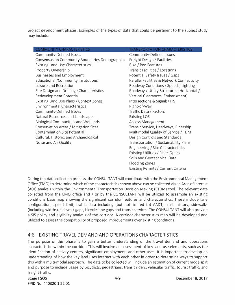
project development phases. Examples of the types of data that could be pertinent to the subject study may include:
COMMUNITY CHARACTERISTICS TRANSPORTATION CHARACTERISTICS Community-Defined Issues Consensus on Community Boundaries Demographics Existing Land Use Characteristics Property Ownership Businesses and Employment Educational /Community Institutions Leisure and Recreation Site Design and Drainage Characteristics Redevelopment Potential Existing Land Use Plans / Context Zones Environmental Characteristics Community-Defined Issues Natural Resources and Landscapes Biological Communities and Wetlands Conservation Areas / Mitigation Sites Contamination Site Potential Cultural, Historic, and Archaeological Noise and Air Quality
Community-Defined Issues Freight Design / Facilities Bike / Ped Features Transit Facilities / Locations Potential Safety Issues / Gaps Parallel Facilities & Network Connectivity Roadway Conditions / Speeds, Lighting Roadway / Utility Structures (Horizontal / Vertical Clearances, Embankment) Intersections & Signals/ ITS Right-of-Way Traffic Data / Factors Existing LOS Access Management Transit Service, Headways, Ridership Multimodal Quality of Service / TDM Design Controls and Standards Transportation / Sustainability Plans Engineering / Site Characteristics Existing Utilities / Fiber-Optics Soils and Geotechnical Data Flooding Zones Existing Permits / Current Criteria
During this data collection process, the CONSULTANT will coordinate with the Environmental Management Office (EMO) to determine which of the characteristics shown above can be collected via an Area of Interest (AOI) analysis within the Environmental Transportation Decision Making (ETDM) tool. The relevant data collected from the EMO office and / or by the CONSULTANT will be utilized to assemble an existing conditions base map showing the significant corridor features and characteristics. These include lane configuration, speed limit, traffic data including (but not limited to) AADT, crash history, sidewalks (including widths), sidewalk gaps, bicycle lane gaps and transit service. The CONSULTANT will also provide a SIS policy and eligibility analysis of the corridor. A corridor characteristics map will be developed and utilized to assess the compatibility of proposed improvements over existing conditions.
4.6 EXISTING TRAVEL DEMAND AND OPERATIONS CHARACTERISTICS The purpose of this phase is to gain a better understanding of the travel demand and operations characteristics within the corridor. This will involve an assessment of key land use elements, such as the identification of activity centers, significant employment, and other uses. It is important to develop an understanding of how the key land uses interact with each other in order to determine ways to support this with a multi-modal approach. The data to be collected will include an estimation of current mode split and purpose to include usage by bicyclists, pedestrians, transit riders, vehicular traffic, tourist traffic, and freight traffic.

Stage I SOS A-10 December 8, 2017 FPID No. 440320 1 22 01
The data required to support an evaluation of travel characteristics is evaluated with the intent of providing a representative sampling sufficient to support a planning-level evaluation. As such, documenting travel demand characteristics can involve a variety of types of data to be collected that may include traffic counts, Bluetooth data capture, travel pattern and onboard surveys, or other methods to approximate origin / destination relationships, and the local or regional traffic composition. The CONSULTANT will coordinate with the DEPARTMENT’S Traffic Operations unit on existing studies conducted in the study area prior to any data collection. To the extent possible, the DEPARTMENT will collaborate with partner agencies during the data collection phase to identify historical data that may already be available and integrate this into the planning assessment. To supplement available data, the following additional data collection efforts may be required as part of the subject project: machine counts to assess daily traffic volumes (tube counts), and Turning Movement Counts (TMC’s) to assess intersection operations for all modes of travel. Vehicle class counts and speed data will be collected at selected locations to allow for a qualitative assessment of existing travel conditions. Pedestrians and cyclist will be included as part of the TMCs. Additional data collection may be required if stakeholder and partner interviews identify “hot spots” that require more detailed analysis. For example, an area could be identified as having a high volume of pedestrians crossing the corridor at unmarked, mid-block locations. In that instance, mid-block crossings may require pedestrian counts analysis and unique strategies to address. Other elements to be considered include transit ridership statistics, transit stop locations, planned transit service, and an examination of land use to identify major activity centers (retail, freight / industrial, medical complexes, etc.) and desire pathways that influence travel patterns. The study will also provide insight into the multimodal relationships that would be required to support the development of context-sensitive alternatives that further encourage the effective operation of the multiple modes of transportation utilizing the corridor, including freight, transit, and bike / ped.
4.6.1 EXISTING CORRIDOR OPERATIONS SUMMARY Using the travel characteristics data collected for the study corridor, perform a Level of Service (LOS) evaluation per Highway Capacity Manual (HCM) procedures as they apply to roadway links, and intersections. A qualitative assessment to establish existing conditions for multi-modal mobility will also be considered. This will identify existing freight and transit usage, operational characteristics, and potential improvements to encourage and further enhance future mobility for all users. As applicable, a summary of multimodal data and performance measures will also be documented for the corridor to set the stage for a look to the future that considers overall operational performance within the context of a Complete Streets approach.
4.7 LAND USE AND COMMUNITY CHARACTERISTICS Land use and transportation are inextricably linked. To support multimodal options, the CONSULTANT shall provide an inventory and analysis of existing land use along the STUDY corridor. In September 2014, FDOT adopted a statewide Complete Streets policy (Topic No. 000-625-017-a). The Policy states:
Stage I SOS A-11 December 8, 2017 FPID No. 440320 1 22 01
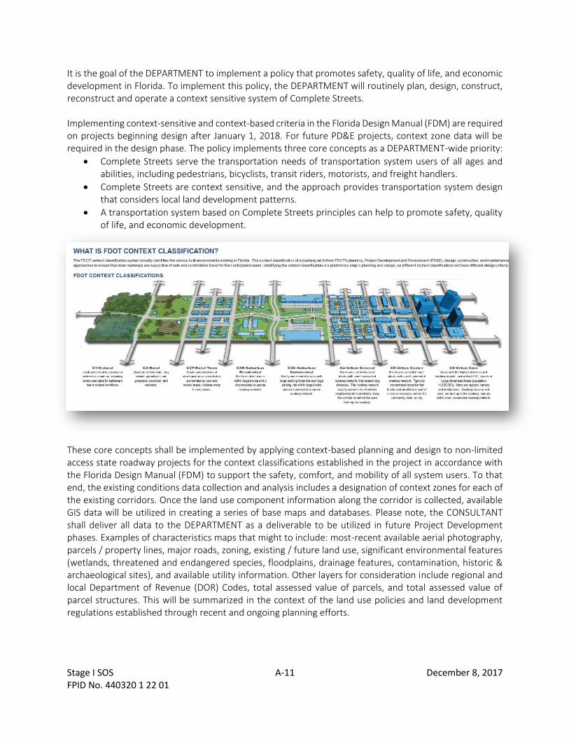
It is the goal of the DEPARTMENT to implement a policy that promotes safety, quality of life, and economic development in Florida. To implement this policy, the DEPARTMENT will routinely plan, design, construct, reconstruct and operate a context sensitive system of Complete Streets. Implementing context-sensitive and context-based criteria in the Florida Design Manual (FDM) are required on projects beginning design after January 1, 2018. For future PD&E projects, context zone data will be required in the design phase. The policy implements three core concepts as a DEPARTMENT-wide priority:
• Complete Streets serve the transportation needs of transportation system users of all ages and abilities, including pedestrians, bicyclists, transit riders, motorists, and freight handlers.
• Complete Streets are context sensitive, and the approach provides transportation system design that considers local land development patterns.
• A transportation system based on Complete Streets principles can help to promote safety, quality of life, and economic development.
These core concepts shall be implemented by applying context-based planning and design to non-limited access state roadway projects for the context classifications established in the project in accordance with the Florida Design Manual (FDM) to support the safety, comfort, and mobility of all system users. To that end, the existing conditions data collection and analysis includes a designation of context zones for each of the existing corridors. Once the land use component information along the corridor is collected, available GIS data will be utilized in creating a series of base maps and databases. Please note, the CONSULTANT shall deliver all data to the DEPARTMENT as a deliverable to be utilized in future Project Development phases. Examples of characteristics maps that might to include: most-recent available aerial photography, parcels / property lines, major roads, zoning, existing / future land use, significant environmental features (wetlands, threatened and endangered species, floodplains, drainage features, contamination, historic & archaeological sites), and available utility information. Other layers for consideration include regional and local Department of Revenue (DOR) Codes, total assessed value of parcels, and total assessed value of parcel structures. This will be summarized in the context of the land use policies and land development regulations established through recent and ongoing planning efforts.

Stage I SOS A-12 December 8, 2017 FPID No. 440320 1 22 01
4.8 EXISTING SAFETY PERFORMANCE The CONSULTANT will complete a Corridor Roadway Safety Audit (RSA) on the US 27 CORRIDOR NORTH study area as well as on high crash rate intersections identified in the Existing Corridor Operations Summary. The Study team will:
• Follow the procedures and documentation of the FHWA “Road Safety Audit – Guidelines and Checklist”; and/or the Highway Safety Manual (HSM),
• Focus on the examination of safety and safety performance; and
• Be advised by an RSA advisory team comprised of the PAG as well as a representation from a core team of disciplines, including but not limited to: Traffic Operations, Geometric Design, Road Safety, Maintenance, and Law Enforcement.
The CONSULTANT will review data for the last five (5) years, such as: traffic volumes; crash data from the FDOT’s CARS and Signal 4 Analytics systems; signal phasing and timing plans; and transit routes, schedules, and stop locations. The CONSULTANT will summarize crash trends with the following data:
• Frequency of crashes by severity (fatal, injury, property damage only),
• Crash type,
• Vehicle movements,
• Number of vehicles involved, and
• Other related environmental factors
The CONSULTANT will also generate crash diagrams for fatal, pedestrian, and bicycle crashes along each study corridor. The Consultant will also “clean” the dataset by re-coding miscoded/“other” crashes as needed.
4.8.1 FIELD REVIEW The CONSULTANT will lead the PAG and the RSA Study team in a pre-audit meeting, field review, and post field-review meeting to evaluate safety conditions along the corridor. The field review should be conducted both during the day and night to document differing conditions. Desktop analysis may suggest additional inspection times such as events or school adjournment or peak truck delivery times.
4.8.2 ROADWAY SAFETY AUDIT REPORT The CONSULTANT will draft a US 27 CORRIDOR NORTH ROADWAY SAFETY AUDIT REPORT with input from the RSA analysis meeting. The full draft report will include photos, graphics, crash data and diagrams, preliminary findings, and suggested countermeasures to be distributed to the PAG and the RSA Study team for review and comment.
5 PHASE II - DEFINE GUIDING PRINCIPLES Based on the findings of the previous tasks and continued input from the stakeholders, the CONSULTANT will develop draft guiding principles in development of improvement alternatives to be agreed to through future partner and stakeholder engagement. For agency stakeholder’s familiar with the planning process, this item could be discussed as part of the initial interviews, or could be summarized by the DEPARTMENT as input into a more-formal discussion to be held as part of the first meeting with the PAG. Ideally, the list of guiding principles should be a brief list of succinct points that speak to what the community thinks is important as it relates to the multi-modal transportation vision and the associated land use goals of the

Stage I SOS A-13 December 8, 2017 FPID No. 440320 1 22 01
study area. The guiding principles should address what the vision is, who the major users are, and what the desired role of the facility is.
5.1 PURPOSE AND NEED Utilizing the results of the visioning phase and input received from the PAG, the CONSULTANT will begin to further define the policy elements of the Corridor Planning process that will feed into the identification of improvement strategies and assessment of these alternatives. Based on quantitative and qualitative data provided by stakeholder and project partners, the CONSULTANT will support the DEPARTMENT in clearly defining the rationale for the US 27 NORTH CORRIDOR MOBILITY STUDY by developing a Purpose Statement and a Supporting Needs Statement. .
6 EVALUATION CRITERIA / MEASURES OF SUCCESS The CONSULTANT will evaluate the proposed conceptual alternatives based on a list of criteria pertinent to issues surrounding the US 27 NORTH CORRIDOR MOBILITY STUDY. The evaluation criteria established as part of the initial corridor assessment may be expanded, or analyzed in more specific detail to support a comparative evaluation of the viable alternatives. The types of evaluation criteria that may be considered as part of this effort may include, but are not limited to:
Travel Characteristics Planning Considerations
Multimodal Traffic Volumes / Mode Split Future Levels of Service Multi-modal Quality of Service * Intersection Geometry / Signalization Access Management Multimodal Traffic Control Plan Pedestrian/Bicycle/Transit Facilities Truck Parking Signage and Wayfinding Engineering Characteristics Design Standards for All Users (Bike, Ped, Transit, Freight) Right of Way Needs Utility Impacts Soils / Geotechnical Issues Drainage / Permitting Needs Safety Requirements / Upgrades Design, R/W and Construction Costs Design and Construction Timeframes
Public-Private Partnerships Implementation / Funding Needs Aesthetics and Landscaping Context-Sensitive Design Special Features Environmental Characteristics Natural Impacts Wetlands, T&E Species Physical Impacts Contamination, Air & Noise Social Impacts Cultural & Historic, Archaeological R/W Impacts and Relocations Community Issues Mitigation Requirements Agency Concerns (ETDM Summary)
*NOTE: As part of the operational analysis, the CONSULTANT will evaluate the degree to which each improvement will meet the project objectives or purpose and needs. This element in the matrix may include quantitative analysis results as applicable, but will also consider qualitative assessments such as congestion

Stage I SOS A-14 December 8, 2017 FPID No. 440320 1 22 01
severity, drainage characteristics, walkability, system / network continuity, impacts to access, and ability to improve multimodal transportation and connectivity.
6.1 CORRIDOR EXISTING CONDITIONS REPORT The data and results of analysis conducted during Phases I and II will be documented within a US 27 CORRIDOR NORTH MULTIMODAL MOBILITY STUDY EXISTING CONDITIONS REPORT. This deliverable will set the stage for additional documentation to be developed in subsequent phases.
6.2 CORRIDOR FUTURE CONDITIONS REPORT The project perspective gained through the needs assessment and initial coordination with the PAG and project stakeholders sets the stage for an assessment of improvement alternatives in context of the future vision. This begins with an understanding of anticipated growth, planned development, and future land use objectives that will impact the form and function of the US 27 NORTH CORRIDOR NORTH MOBILITY STUDY corridor. Following a context-sensitive approach that emphasizes the livability, economic vitality, and multimodal planning vision for the corridor, the CONSULTANT will:
• Review relevant traffic projections from other studies, local and regional growth trends, and LRTP future year model projections.
• Assess the future land use and development potential within the study corridor with an emphasis on freight including known or expected major generators;
• Identify future land use changes, planned and programmed improvements to utilities, roadway, freight, pedestrian, bicycle and transit elements;
• Utilizing readily-available model outputs and/or a trends analysis with assumed growth rates, identify a reasonable estimated range of person trip volume projections within the study area during the design year (anticipated to be 2045);
• Utilizing the currently-adopted travel demand forecasting model from the Polk TPO, the CONSULTANT will evaluate the validity of the base year traffic forecasts and update, as necessary, the highway network and socio-economic data. All programmed and planned roadway improvements will be verified, documented and included into the transportation model. In addition, the CONSULTANT will coordinate with impacted local municipalities to identify and quantify any approved/development traffic and the source of the project. Based on the aforementioned information, the CONSULTANT will assemble the year 2045 base-line future forecasts for the study corridor roadways and intersections;
• Perform an initial operational analysis with future traffic volumes to identify deficiencies at key intersections and roadway segments based on the existing conditions;
• Utilizing the results of the initial operational analysis, identify potential land use changes or other requirements that could be considered to encourage use by alternate modes.
The result of the future conditions evaluation and identification of potential corridor needs developed will be documented within a US 27 Corridor North Multimodal Mobility Study Future Conditions Report and provided to the DEPARTMENT Project Manager. This technical memorandum is a concise document which will set the stage for the discussion of the purpose and need, as well as future corridor conditions, at the public involvement kick-off workshop.
Stage I SOS A-15 December 8, 2017 FPID No. 440320 1 22 01
6.3 LONG-RANGE NEEDS ASSESSMENT Utilizing the forecast data, results of the future conditions assessment, and input from the PAG, identify as series of improvement needs to be evaluated. Development patterns, redevelopment opportunities, and regulations play a major role in determining the type of multimodal alternatives that are appropriate for the corridor. Consideration shall be given to maximizing opportunities for utilization of non-vehicular modes such as bicycle, pedestrian and transit consistent with to Chapter 14 of the Project Development & Environment Manual and the Florida Design Manual. Types of enhancement needs could possibly include:
• Improving parallel roadways and/or network connectivity in the vicinity of the corridor;
• Constructing limited access highway facilities within or adjacent to the corridor;
• Operations strategies to provide for long-term capacity needs;
• Multimodal strategies to increase the movement of people and goods in and through the US 27 corridor.
The results of the visioning phase will be documented in a Purpose and Needs Summary, which will highlight stakeholder input received from the PAG, a summary of planning goals and objectives, and a range of potential improvement strategies to be evaluated in the next phase.
7 PHASE III - DEFINE AND SELECT ALTERNATIVES This portion of the US 27 CORRIDOR NORTH MOBILITY STUDY will focus on the viable improvement strategies and funding scenarios that address conditions identified in earlier phases. Based on input received from project stakeholders in the previous task, the CONSULTANT shall prepare initial conceptual plans or exhibits illustrating the range of possible alternatives. Such materials may include sketch-level typical sections that show key elements such as travel lanes, median enhancements, transit features, freight features, sidewalks, trails, and / or pedestrian amenities. Other types of exhibits might include aerial-based overlays showing locations of transit shelters; bus pull-outs; freight design recommendations, such as longer about longer accel/decel lanes and wider radii turn lanes for freight mobility; Intelligent Transportation System (ITS) features; and other improvements that are compatible with planned and ongoing redevelopment projects that provide higher densities of residential, industrial, office, and commercial uses. Utilizing the information developed in previous Tasks, the CONSULTANT shall finalize the alternatives with consideration of the desires of the community and stakeholders in order to satisfy the requirements of the Department’s policy on Context Sensitive Solutions and design standards in the Florida Design Manual. Examples of the types of improvement recommendations that can be anticipated for this evaluation may include, but are not limited to:
• Conceptual geometric improvements that may include intersection modifications, or improvements to parallel facilities that improve overall network connectivity and transit and / or freight.
• Exhibits to include sufficient detail to support an assessment of potential impacts and project costs (Design, R/W, and Construction), with details such as horizontal and vertical roadway geometry at critical locations, significant structures, intersection details, major utilities, significant drainage features, existing and proposed right-of-way lines, edges of pavement and median openings. A suitable design schedule shall also be provided as guidance to the DEPARTMENT in support of subsequent phases.
• Operational and ITS improvements such as signal system modifications and utilization of newer technologies such as Adaptive Signal Control, and/or enhance ITS communication/monitoring tools;
Stage I SOS A-16 December 8, 2017 FPID No. 440320 1 22 01
• Recommendations for crosswalks, improved crossings, and other pedestrian and bicycle oriented access improvements;
• Land use policy modifications,
• Transit system and passenger rail improvements; and
• Freight mobility improvements. Leading into the alternatives development process, the DEPARTMENT should have a complete understanding of key project issues, purpose and need, and the evaluation criteria with which improvement strategies will be evaluated in order to determine their measures of success. In short, with the planning foundation now in place, the study is ready to begin developing alternatives. This begins by engaging the PAG to identify a range of potential improvement options that support the purpose and need and reinforce the guiding principles. To support this process, the CONSULTANT will develop initial concepts, or facilitate an interactive workshop in which stakeholders are engaged to develop alternatives with assistance from the DEPARTMENT.
7.1 ALTERNATIVE PRELIMINARY ENGINEERING / ENVIRONMENTAL ASSESSMENT An assessment of the operational characteristics of the improvement strategies will be conducted as input into the evaluation of future “build” conditions. For the types of improvement strategies likely to be included as part of this Corridor Planning Study, a network analysis involving use of the regional travel demand model will be developed to evaluate the network benefits that will be realized by the proposed improvements that have been identified through the planning process. A more refined operational analysis of viable alternatives will include using Synchro or other HCM-compatible analysis tools to evaluate projected peak hour conditions, and better-identify turning capacity needs at intersections. It is noted that the evaluation of multiple alternatives involving an analysis that requires travel demand modeling and operational analyses can be costly. To the extent possible, the DEPARTMENT will seek input and technical support from the TPO to help offset the costs of conducting an evaluation involving these tools. As needed, the planning effort may also consider a longer-term assessment involving an aggregate “supply/demand” analysis of corridor demand. Unlike conventional methods, this may involve an iterative mode split analysis, involving the identification of target splits required to achieve an acceptable multi-modal quality of service, rather than applying a traditional method of identifying the mode split assumptions associated with a particular strategy. Mode split outcomes for local and regional trips needed to achieve the shared regional vision and specific corridor strategy will be identified, which lead to needs related to future land use and related policy modifications needed to achieve those targets. Utilizing the evaluation criteria and input received during workshops and coordination with the PAG, partners, and stakeholders, the CONSULTANT shall conduct a due-diligence / fatal flaw evaluation of the improvement strategies and recommendations that involves:
• evaluation of future travel characteristics for all users within the corridor (motorized, non-motorized, freight, tourism, etc.), including the multimodal distribution between modes;
• preliminary assessment of engineering issues (geometrics, drainage, potential R/W needs, and others) as needed to support a review and comparison of alternatives by the DEPARTMENT;
• desktop assessment (using the Environmental Screening Tool and/or GIS) to evaluate the potential for environmental impacts (social, natural and physical) to be further explored during subsequent phases
• assessment of the financial and policy implications of the individual options to include relative project costs (Design, R/W, and Construction) that may be either qualitative (i.e., $, $$, $$$) or

Stage I SOS A-17 December 8, 2017 FPID No. 440320 1 22 01
quantitative utilizing planning-level estimates, or cost-per-mile models that can be developed with minimal effort;
• assessment of potential land use patterns to support the options, and a fatal flaw screening process of these options;
7.2 IDENTIFICATION OF VIABLE ALTERNATIVES AND EVALUATION CRITERIA At the point when the alternatives brainstorming conducted with the PAG has been documented, the CONSULTANT will formulate a summary of potential options and coordinate with the DEPARTMENT to identify a range of viable improvement alternatives to be further advanced as part of the STUDY. This will involve further refinements to the exhibits created in the initial brainstorming to a level of detail sufficient to communicate the project concepts to various disciplines within the DEPARTMENT that will provide input into the planning process. With input received from the PAGs, the CONSULTANT will develop evaluation criteria for the comparison of corridor alternatives, and identify the range of viable alternatives and improvement strategies. These alternatives and strategies would need to be evaluated in greater detail in future Project Development phases. A due diligence evaluation of improvement alternatives will then be developed to support discussions amongst the DEPARTMENT and Project Partners and Stakeholders as viable alternatives to be advanced into Project Development. Once developed and refined, planning-level conceptual plans will be shared with the Internal Review Team, who will review the alternatives in detail and provide a better understanding for potential issues and other challenges to be considered in further detail. The Internal Review Team coordination will ensure that any significant potential issues with the project are identified at an early stage so that they can be addressed before advancing beyond planning. It is noted conceptual plans will also be reviewed in greater detail during the Project Development, or PD&E stage that will follow this effort as well. For the viable alternatives identified to move forward following the internal review, additional detail will be developed to identify corridor segmentation, specific typical section elements and options, alignment alternatives, consistency with locally-adopted plans, and other aspects to be considered during PD&E, if applicable. Also as part of the Alternatives Evaluation phase, the appropriate coordination shall be conducted to identify and develop Joint Project Agreements with project stakeholders and agency partners to the extent possible.
7.3 ALTERNATIVES AND STRATEGIES SUMMARY REPORT The result of this phase of the study will be a US 27 CORRIDOR NORTH MULTIMODAL MOBILITY STUDY ALTERNATIVES AND STRATEGIES SUMMARY that includes more-refined cost estimates for Design, R/W, and Construction, as well and identification of issues related to potential near-term and long-term implementation strategies.
7.3.1 PLANNING-LEVEL COST ESTIMATES The CONSULTANT shall develop project cost estimates for each viable improvement alternative evaluated as part of the Preliminary Engineering Analysis. Total project cost is comprised of components that include design, right-of-way, construction, and CEI. The Construction cost estimate can be developed using the

Stage I SOS A-18 December 8, 2017 FPID No. 440320 1 22 01
DEPARTMENT’S long range estimating (LRE) system, or other comparable estimating methods. The design component can be estimated using the District’s Staff-Hour estimation guidelines and related forms using average estimated staff-hour rates. For improvements requiring substantial additional right-of-way for improvements such as off-site stormwater ponds, the DEPARTMENT will provide support to develop the right-of-way cost estimate. Right-of-way impacts are not anticipated for most Corridor Planning Studies having a focus on multimodal improvements. Investigation of one-way pairs or other alternatives involving parallel corridors, however, may require an assessment of right-of-way impacts. The DEPARTMENT will review and concur with all cost estimates. Note: Some of the improvements identified may not be eligible for funding through the Department. Examples would include, but are not limited to most aesthetic enhancements such as irrigated landscaping, decorative lighting fixtures, and street furniture. To the extent that such enhancements are incorporated into state facilities, this would be funded by an agency partner or through other secured funding sources under a joint project agreement.
7.3.2 QUALITATIVE EVALUATION OF ALTERNATIVES The CONSULTANT will prepare a summary of opportunities and constraints. Alternatives will be qualitatively compared and evaluated based upon the previously identified evaluation criteria and/or measures of success. Utilizing the established evaluation criteria, prepare a matrix comparing the project opportunities and constraints. This will include a qualitative summary of anticipated impacts and costs associated with the various improvement strategies. This step will be used to support coordination with the PAG as part of the process to identify the alternative(s) recommended for implementation. The CONSULTANT shall analyze and evaluate each desired improvement to a point of sufficient decision making as a viable improvement. The impacts for each improvement shall be identified and expressed in a form suitable for comparison to other corridor improvements.
7.3.3 PROJECT DELIVERABLE: CONCEPTUAL PLANS / EXHIBITS The CONSULTANT shall provide a preliminary set of the conceptual plans and exhibits as a result of the alternatives development, which includes the previous preliminary assessment and qualitative comparison / evaluation. This will likely include a table of design criteria to guide the future development of multimodal recommendations, safety enhancements, and bicycle/ pedestrian improvements. The conceptual plans will be provided to the DEPARTMENT on roll plots to help facilitate thought and feedback, as well as on aerial figures summarizing the type of proposed alternative(s), location, and caveat to the various improvement strategies. As part of this deliverable, the CONSULTANT will hold project review meetings with District planning, program management, design, and traffic operations staff with the purpose of reviewing key elements such as design speeds, typical sections, and the configuration proposed improvements.
7.3.4 PROGRAMMING AND PROJECT IMPLEMENTATION As a result of the US 27 CORRIDOR NORTH MULTIMODAL MOBILITY STUDY, the CONSULTANT will provide a summary of the key issues and concerns, as well as provide direction to the DEPARTMENT staff responsible for advancing the project in the next phase of Project Development (e.g. design, traffic operations, or PD&E). The intent of this task is not for the CONSULTANT to develop the Scope of Services, but rather provide an overview of the key project issues and decisions resulting from the planning efforts, so that they can be reflected within the scope of services for the next phase. The deliverable may follow, or will be similar to, the template developed by the Program Management unit. This will include a summary discussion of items, such as, but not limited to:

Stage I SOS A-19 December 8, 2017 FPID No. 440320 1 22 01
• Basic project information o FPID No., State Road, Limits, Mile Posts, posted/design speeds, Related Projects by others, etc.
• Summary of project-specific characteristics: o Need for R/W, bridges, utilities, MOT/construction concerns, CAP level required, list of agency
partners / stakeholders, CD of study reports and other.
• Purpose and Need Summary / Project Description o Summary of key issues pertaining to next phase scope items:
• Physical Constraints / Issues: Roadway, R/W, drainage, utilities, traffic operations, multi-modal features (bike, pedestrian, transit), lighting, structures, contamination. o Data and Permitting Needs: Survey requirements, geotechnical requirements, required agency permits,
design variations/exceptions.
Depending on the nature of the improvement recommendations, the CONSULTANT may assist the DEPARTMENT in preparation of an INPUT PACKAGE to support a Planning or Programming screen in ETDM. This will involve development of a summary information package that includes project overview information, exhibits that describe the proposed improvements in PDF format, a purpose and need statement, and other elements as requested by the Department’s ETDM Coordinator.
7.3.5 POST-EVALUATION PAG MEETING As a result of the Alternatives Development Public Workshop, the CONSULTANT shall hold a post evaluation team meeting with the PAG to discuss the selected alternatives and next steps. The CONSULTANT will provide a brief summary within the report outlining guidance and potential next steps for the implementation of the recommendations based on the post evaluation team meeting.
8 CORRIDOR ALTERNATIVES AND STRATEGIES REPORT The CONSULTANT shall prepare a US 27 NORTH CORRIDOR MULTIMODAL MOBILITY STUDY CORRIDOR ALTERNATIVES AND STRATEGIES REPORT that collects the reports noted previously into one, cohesive, user-friendly plan. Once approved, a copy of the US 27 NORTH CORRIDOR MOBILITY STUDY CORRIDOR ALTERNATIVES AND STRATEGIES REPORT will be shared with project partners and stakeholders. This report will highlight key issues, stakeholders input, and a summary of the alternatives developed in the previous tasks. The summary shall also provide a discussion on the identification of potential barriers to implementation for the preferred regulatory and institutional facets. This task will also identify the necessary actions anticipated from the private sector to maximize the support for the preferred alternative(s) and staging plans. Additional elements include the identification of existing funding partners, as well as any and all agency commitments, with the background reasons / history, identification of responsibilities, consideration of preliminary funding agreements, unresolved issues, implementation phasing, appropriate delivery method (i.e. Maintenance contract, Design-Build, RRR, pushbutton, etc.), relative correspondence, etc. The information provided in the Corridor Alternatives and Strategies Report is a compilation of material that was gathered in previous tasks. This document will also include an outline of project priorities and a recommended plan for implementation with descriptions of the phases needed for each proposed project on the priority list, anticipated timelines, and responsible parties to help guide the next step of the project, whether the improvements are short-term or long-term improvements. In addition, the purpose and needs statement should be revisited and revised (if necessary) for each of the selected alternative(s).
Stage I SOS A-20 December 8, 2017 FPID No. 440320 1 22 01
In addition, the CONSULTANT will provide a complete package of relevant project materials and consolidation of final documents to the DEPARTMENT, as it is an important step when the study is passed to the next phase. The final package of the study should include, but not limited to:
• Project Archive CD of all Study-related materials / Final Documents
• Comments & Coordination Summary
• Project contacts / listing of stakeholders
• Summary table of all public meetings (meetings, workshops) with dates, attendees, number of comments received.
• Summary of comments received with responses.
8.1 PROJECT DEBRIEF MEETING The CONSULTANT shall attend a post-project debriefing meeting with the DEPARTMENT to discuss lessons learned and evaluate the effectiveness of various elements involved in the project. The purpose of this meeting is to provide a positive and open interaction as part of a valuable feedback loop that will support the continued evolution and refinement of the Corridor Planning Study process. The CONSULTANT will provide a summary report of the debrief proceedings and findings in the US27 CORRIDOR NORTH MOBILITY STUDY DEBRIEF AND AFTERACTION REPORT.