final eia report - national environment & planning...
TRANSCRIPT

EIA Report Environmental Solutions Ltd.
Highway 2000: Phase 1a Portmore Causeway TransJamaican Highway Ltd. ii
TABLE OF CONTENTS Executive Summary…………………………………………………………….……….a TABLE OF CONTENTS ................................................................................................. ii List of Tables……………………………………………………………………………..v List of Figures…………………………………………………………………..……….vi List of Plates……………………………………………………………..…..…………vii List of Appendices……………………………………………………..………………viii 1.0 INTRODUCTION................................................................................................. 1
1.1 PURPOSE.......................................................................................................... 2 1.2 Terms of Reference ................................................................................................ 3 1.3 Approach and Methodology ................................................................................. 8
1.3.1 STUDY TEAM................................................................................................ 8 1.3.2 Data Collection.............................................................................................. 10
1.3.2.1 Physical Environment.............................................................................. 11 1.3.2.2 Geology, Topography, Soils .................................................................... 11 1.3.2.3 Hydrology and Drainage ......................................................................... 11 1.3.2.4 Air Quality................................................................................................. 11 1.3.2.5 Noise ........................................................................................................... 12 1.3.2.6 Water Quality............................................................................................ 12
1.3.3 Biological Environment ............................................................................. 14 1.3.3.1 Flora ........................................................................................................... 14 1.3.3.2 Fauna.......................................................................................................... 14
1.3.3.3 SociO-CULTURAL Environment............................................................ 14 2.0 PROJECT DESCRIPTION ............................................................................... 15
2.1 Alignment......................................................................................................... 15 2.2 Phasing and Timetable ................................................................................... 16 2.3 Construction Camp/Site Office...................................................................... 17 2.4 Sourcing, Transport and Deployment of Fill Material................................ 17 2.5 Shoreline Protection Works .......................................................................... 18 2.6 Demolition Works for Existing Bridge ......................................................... 18 2.7 Solid Waste Disposal (Construction Spoil and Demolition Waste) ............ 18 2.8 Mangrove Removal and Coastal Filling ....................................................... 19
3.0 PERMITTING .................................................................................................... 19 4.0 NATIONAL LEGISLATIVE AND REGULATORY CONSIDERATIONS – NATURAL ENVIRONMENT....................................................................................... 20
4.1 Natural Resources Conservation Act (1991) ................................................ 20 4.2 Environmental Review and Permitting Process (1997)............................... 20 4.3 Wildlife Protection Act (1945) ....................................................................... 21 4.4 The Endangered Species (Protection, Conservation and Regulation of Trade)........................................................................................................................... 21 Act (1999)........................................................................................................ 21 4.5 The Natural Resources (Prescribed Areas)(Prohibition of Categories of Enterprise, Construction and Development) Order (1996) .................................... 21 4.6 Water Resources Act (1995)........................................................................... 22 4.7 Country Fires Act (1942)................................................................................ 23

EIA Report Environmental Solutions Ltd.
Highway 2000: Phase 1a Portmore Causeway TransJamaican Highway Ltd. iii
4.8 Quarries Control Act (1983) .......................................................................... 23 4.9 The Pesticides (Amendment) Act (1996)....................................................... 24 4.10 Air Quality Standards .................................................................................... 24 4.11 Noise Standards............................................................................................... 25 4.12 Water Quality NRCA Act (1990)................................................................... 25 4.13 The Beach Control Authority (Licensing) Regulations (1956) ................... 25
5.0 NATIONAL LEGISLATIVE AND REGULATORY CONSIDERATIONS – HUMAN, CULTURAL AND SOCIAL ENVIRONMENT......................................... 26
5.1 Town and Country Planning Act (1958)....................................................... 26 5.2 Land Development and Utilization Act (1966)............................................. 27 5.3 The National Solid Waste Management Authority Act (2001)................... 28 5.4 Jamaica National Heritage Trust Act (1985)................................................ 28 5.5 Land Acquisition Act (1947) .......................................................................... 29 5.6 Registration of Titles Act (1989).................................................................... 30 5.7 Involuntary Resettlement Policy ................................................................... 30 5.8 Mining Act (1947) ........................................................................................... 31 5.9 Toll Roads Act (2002) ..................................................................................... 31
6.0 INTERNATIONAL LEGISLATIVE AND REGULATORY CONSIDERATIONS ...................................................................................................... 32
6.1 Cartagena Convention (Convention for the Protection and Development of the Marine Environment of the Wider Caribbean Region) (1983) ........................ 32 6.2 Biodiversity Convention ................................................................................. 33
7.0 DESCRIPTION OF THE EXISTING ENVIRONMENT ................................... 34 7.1 Physical Environment.......................................................................................... 34
7.1.1 Topography ................................................................................................... 34 7.1.2 Geology and Soils ........................................................................................... 34 7.1.3 Climate ........................................................................................................... 35 7.1.4 Hydrology, Drainage and Coastal Dynamics ............................................. 39 7.1.5 Hazard Vulnerability.................................................................................... 41
7.1.5.1 Seismicity Activity................................................................................... 41 7.1.5.2 Storm Surge......................................................................................... 42 7.1.5.3 Ponding ................................................................................................ 43
7.1.6 Air Quality and Noise ................................................................................. 43 7.1.6.1 Historical Air Quality Data............................................................... 43 7.1.6.2 Measurements made during the EIA (2002-2003) .......................... 44
7.1.7 Noise ............................................................................................................... 45 7.1.8 Water Quality................................................................................................ 46
7.2 Biological Environment ....................................................................................... 50 7.2.1 Flora .............................................................................................................. 50 7.2.2 Fauna............................................................................................................. 50 7.2.3 Wetlands ...................................................................................................... 54 7.2.4 Marine Environment .................................................................................... 55
7.3 Social Environment............................................................................................... 55 7.3.1 Housing Settlements...................................................................................... 56 7.3.2 Zoning and Land Acquisition ...................................................................... 57 7.3.3 Land Use and Municipal Status .................................................................. 58

EIA Report Environmental Solutions Ltd.
Highway 2000: Phase 1a Portmore Causeway TransJamaican Highway Ltd. iv
7.3.3.1 The Road.............................................................................................. 58 7.3.3.2 The Port ............................................................................................... 58 7.3.3.3 Portmore .............................................................................................. 59 7.3.3.4 Surrounding Land Use/Commercial Environs ................................ 60
7.3.4 Traffic, Transportation and Access Roads................................................. 61 7.3.5 Demographics................................................................................................ 62 7.3.6 Livelihoods..................................................................................................... 63
7.3.6.1 Fishing.................................................................................................. 63 7.3.6.2 Portmore Residents............................................................................. 64
7.3.7 Relocation Requirements ........................................................................... 65 7.3.8 Community Facilities.................................................................................. 67 7.3.9 Solid Waste Management........................................................................... 67 7.3.10 Recreation.................................................................................................... 68 7.3.11 Archaeological and Cultural Heritage ...................................................... 68
8.0 CONSIDERATION OF ALTERNATIVES ..................................................... 69 8.1 ALIGNMENT ................................................................................................. 69 8.2 BRIDGE DESIGN .......................................................................................... 70
8.2.1 Bridge Span and Design ............................................................................... 70 8.2.2 Bridge Location............................................................................................. 72
8.3 Construction Camp......................................................................................... 72 8.4 Sourcing of Materials ..................................................................................... 73 8.5 No Action Alternative ..................................................................................... 75
9.0 DETERMINATION OF POTENTIAL IMPACTS.............................................. 76 9.1 Alignment......................................................................................................... 79 9.2 Site Preparation Construction and Operation Phases ................................. 85 9.3 POSITIVE IMPACTS.................................................................................. 124
9.3.1 Physical Environment................................................................................ 124 9.3.2 Biological Environment ............................................................................. 124 9.3.3 Social Environment.................................................................................... 124
10.0 Stakeholder Consultations ............................................................................... 125 10.1 Consultations with Stakeholders ................................................................. 126 10.2 Community Meetings.................................................................................... 126
10.2.1EIA Hearing ................................................................................................ 127 10.3 Communications Schedule .......................................................................... 127 10.4 Future Public Meetings ................................................................................ 127
11.0 Monitoring Programme.................................................................................... 128 12.0 SUMMARY AND CONCLUSIONS .................................................................. 128

Environmental Impact Assessment Environmental Solutions Ltd.
Highway 2000: Phase 1a Portmore Causeway TransJamaican Highway Ltd. 1
1.0 INTRODUCTION
Highway 2000 (H2K) is one of the Government of Jamaica’s landmark Millennium
Projects. It will link Kingston to Montego Bay, through the parishes of Kingston & St.
Andrew, St. Catherine, Clarendon, Manchester, St. Elizabeth, Westmoreland and St.
James. The Highway will also connect Bushy Park and Ocho Rios, traversing the
parishes of St. Catherine and St. Ann. The total length of the highway is approximately
230 km, with an anticipated right-of-way of 100m.
Segment 1 of the Highway 2000 Project has been divided into two phases as follows:
o Phase 1A will include extensive work on the Portmore Causeway, as well as work
from Kingston to Sandy Bay. This will include construction of four lanes from
Kingston to Bushy Park (2x2) and doubling of the Old Harbour Bypass (by
construction of a second 2 lane carriageway).
o Phase 1B will include construction of the highway from Sandy Bay to
Williamsfield, incorporating the existing Melrose bypass, construction of the May
Pen interchange, and a main toll plaza at Williamsfield.
A Strategic Environmental Assessment (SEA) requested by the National Development
Bank of Jamaica Ltd., the executing agency for the project was conducted by Dessau-
Soprin International Ltd., of Canada in association with local partners including
Environmental Solutions Ltd. (Development Bank of Jamaica Ltd, 2000 a-e). The SEA
recommended issues for detailed project-level Environmental Impact Assessment (EIA)
which would be necessary to support the application for an environmental permit. Within
the Kingston to Williamsfield corridor ten areas were recommended for EIA studies.
These were Portmore, Portmore Causeway, Rio Cobre, Bushy Park, Freetown, Rio
Minho, Milk River, Sandy Bay, Porus and Williamsfield. These areas were selected
because of issues related to community, infrastructure, settlements, economic enterprise,
relocation, loss of economic activity, proposed interchanges, water resources, hazard
vulnerability, hydrology, coastal dynamics, air quality and noise.

Environmental Impact Assessment Environmental Solutions Ltd.
Highway 2000: Phase 1a Portmore Causeway TransJamaican Highway Ltd. 2
On Tuesday, June 26, 2001, the Prime Minister of Jamaica announced that Bouygues
Travaux SA of France was selected as the Preferred Bidder for Segment I of the
Highway, which will run from Kingston to Williamsfield. Environmental Solutions Ltd.
has been contracted by TransJamaican Highway Ltd. to conduct the EIA for the
expansion of the Portmore Causeway, which will be executed as a component of Phase 1
of the project.
1.1 PURPOSE
This document presents the findings of the Environmental Impact Assessment of the
proposed Portmore Causeway upgrading and bridge construction. The EIA was
conducted in support of the environmental permit application submitted to the National
Environment and Planning Agency and meets the Terms of Reference approved by that
regulatory agency (See Section 1.2). The Portmore Causeway project (Figure 1.1) is a
component of Phase 1A of the Highway 2000 project being developed by TransJamaican
Highway Ltd. under contract with the Government of Jamaica.
Phase IA of the Highway 2000 Project includes Kingston to Sandy Bay and the Portmore
Causeway and Dyke Road. Phase 1B will see the construction of the highway from
Sandy Bay to Williamsfield in Manchester. Construction for the section from Kingston
to Sandy Bay has already commenced and includes:
o Doubling of the Old Harbour Bypass by construction of the a second two lane
carriageway, reconstruction of the northern ramps of the interchange and
extension of the main toll plaza with maintenance centre, with the tolling
operation of the Kingston to Sandy Bay section as an open system
o The tolling of the two lanes of the existing Old Harbour Bypass (km 21.0 to 33.7)
and the implementation of a main toll plaza on the east of the eastern ramps
o Construction of a four lane highway (2x2) between Kingston and Bushy Park with
interchanges at Mandela Highway (km 0.3), Portmore Access Road (km 1.2) and
Spanish Town (km 7.4) and the implementation of a ramp toll plaza on the
eastbound ramps of the Spanish Town interchange.
Environmental Impact Assessment Environmental Solutions Ltd.
Highway 2000: Phase 1a Portmore Causeway TransJamaican Highway Ltd. 3
1.2 TERMS OF REFERENCE
Based on the NRCA’s “Guidelines for Conducting EIA’s” the Terms of Reference for
conducting the EIA of the Portmore Causeway were prepared and submitted to
NRCA/NEPA for review. This approval was granted in a letter dated October 17, 2002
(Appendix I) with some additions and emphasis, as detailed in the letter.
The final TOR’s for conducting the EIA are as follows:
1. Introduction – Identification of the development project to be assessed and
explanation of the executing arrangements for conducting the Environmental Impact
Assessment.
2. Background Information – A brief description of the major components of the
proposed project, the implementing agents, a brief history of the project and its current
status, including information on the entire Highway 2000 Project, the establishment of
the National Road Operating and Construction Company Ltd. (NROCC) and selection of
Bouygues Travaux Publics as the Preferred Bidder.
3. Study Area – Specification of the boundaries of the study area for assessment
including the Portmore Causeway entrance, the Hunt’s Bay Bridge, the Dyke Road and
the Toll Plaza, as well as adjacent or remote areas that should be considered with respect
to the project.
4. Scope of Work – Standard environmental impact assessment techniques
including site reconnaissance, literature review, desktop research, field work, data
analysis and interviews with appropriate personnel, will be utilized in order to satisfy the
Terms of Reference. Reference will also be made to the extensive studies already
carried out for the Highway 2000 Project including the SEA, Illustrative Design and

Environmental Impact Assessment Environmental Solutions Ltd.
Highway 2000: Phase 1a Portmore Causeway TransJamaican Highway Ltd. 4
Construction Solution, Drainage and Hydrology Report and other relevant studies The
following tasks will be performed:
Task 1: Description of the Proposed Project. A full description will be
given of the project and its existing setting, using maps as appropriate. This is to
include general layout, size, location, and physical characteristics and include
major activities required such as dredging and bridge demolition. The Client will
be expected to provide an aerial survey photograph of the site, a topographical
survey map of the site, engineering designs and relevant plans. Special attention
will be paid to the following:
Sourcing and transport of material to be used as fill
Method for deployment of the fill material
Method for construction of shoreline protection work associated with the
fill
Methods to be employed to control sedimentation from fill activities
Bridge construction
Task 2: Description of the Existing Environment. Assemble, evaluate
and present data on the relevant characteristics of the study area, including the
following:
o Physical environment: geology, topography, soils, surface and coastal dynamics,
siltation in Hunt’s Bay, water quality, water currents, storm surge vulnerability
o Air quality: particulates (PM10, SOX and NOX) and noise assessment
o Natural drainage features: surface run-off and flood (risk) hydrology
o Biological environment: wetlands, marine fauna, fisheries
o Socio-cultural environment: land use, traffic patterns, proposed developments,
public health issues, demography, solid waste management, sewage disposal
o Development plans for Kingston Harbour – Ports and Airport, especially Hunt’s
Bay reclamation.
Environmental Impact Assessment Environmental Solutions Ltd.
Highway 2000: Phase 1a Portmore Causeway TransJamaican Highway Ltd. 5
Surveying and soil analysis will not be undertaken as part of this study as it is
envisaged that such data will be available for consultation and use from other
studies.
Task 3: Legislative and Regulatory Considerations. A description will
be given of the pertinent regulations, standards and regulatory bodies governing
environmental quality, health and safety, protection of endangered species, siting
and land use control, sewage and solid waste disposal, development and
construction.
Task 4: Determination of Potential Impacts of the Proposed Project.
Impacts will be determined as significant positive or negative, direct or indirect,
short-term or long-term, unavoidable or irreversible. Special emphasis will be
placed on:
o Maintenance of Existing Bridge Span vs Increase in Bridge Span
o Relocation/Resettlement requirements
o Traffic Flow
o Interchange and Toll Plaza
o Public sentiment
o Sourcing, Transport and Deployment of Fill Material
o Shoreline Protection Works
o Vehicle Maintenance and Fuel Storage
o Noise and Air Quality
o Loss of Wetlands
o Water Quality
o Bridge Construction
o Demolition Works
o Waste Disposal (construction spoil, demolition waste and sewage)
o Hazards and Risks (flooding, storm surges, health and safety, accidents)

Environmental Impact Assessment Environmental Solutions Ltd.
Highway 2000: Phase 1a Portmore Causeway TransJamaican Highway Ltd. 6
Preparation of a resettlement plan is not included in this scope of work.
Task 5: Mitigation and Management of Negative Impacts.
Recommendations will be made for feasible and cost-effective measures to
prevent or reduce significant negative impacts to acceptable levels. This will
include recommendations related to widening the causeway on the Hunt’s Bay
side or the Kingston Harbour side; sourcing and transport of fill materials; and fill
activities. Indicative costs of these mitigation measures will be provided.
Alternatives to the project site will be investigated including the “no-action”
alternative.
Task 6: Recommendations for the development of a Monitoring Plan.
Recommendations will be made for the development of a Monitoring Plan to
ensure implementation of the mitigation measures and long-term minimization of
negative environmental impacts. Monitoring should begin at the start of the
construction phase and continue throughout the operation phase.
Task 7: Assist in Inter-Agency Coordination and Public Participation.
As, and if required by the NRCA/NEPA, ESL will assist in the public
participation/review process through meetings with relevant governmental
agencies, in obtaining the views of civil society and participation in a public
hearing/consultation. ESL will represent TransJamaican Highway Ltd. before the
NRCA/NEPA and any other government agencies, as required.
5. Report – the Environmental Impact Assessment report will be concise and
limited to the significant environmental issues. The main text will focus on
findings, conclusions and recommended actions, supported by summaries of
the data collected and citations for any references used in interpreting those
data. The report will be organized according to, but not necessarily be limited
by, the outline below:
Environmental Impact Assessment Environmental Solutions Ltd.
Highway 2000: Phase 1a Portmore Causeway TransJamaican Highway Ltd. 7
o Executive Summary
o Description of the Proposed Project
o Description of the Environment
o Policy, Legal and Administrative Framework
o Significant Environmental Impacts and Mitigation Measures
o Analysis of Alternatives
o Recommendations for Monitoring Plan
o List of References
o Photographs, Maps and Plans as appropriate
o Summary of Public Consultation Process
6. Approach – ESL is executing the EIA based on the Terms of Reference as
approved by NEPA, and in accordance with instructions from the client,
TransJamaican Highway Ltd.

Environmental Impact Assessment Environmental Solutions Ltd.
Highway 2000: Phase 1a Portmore Causeway TransJamaican Highway Ltd. 8
1.3 APPROACH AND METHODOLOGY
1.3.1 STUDY TEAM A multidisciplinary team was identified to conduct the study and comprised the following
persons:
Mrs. Eleanor Jones, MSc – Environmental Management Specialist and Team Leader Mrs. Jones has over twenty-five experience in the areas of environmental management
systems, environmental risk assessment, disaster prevention planning, environmental and
social impact assessments, watershed management and community consultations and
participatory planning. Mrs. Jones lectured in the Department of Geography of the
University of the West Indies for 13 years, and has been consulting for fifteen years as
President of Caritech Associates Ltd. and Managing Director/Founding Partner of
Environmental Solutions Ltd. Mrs. Jones has much experience in road development
projects including work on the North Coast Highway, the Kingston Coast Road Upgrade,
the Jamaica Bridges Development Program, and was extensively involved in the SEA for
Highway 2000. Mrs. Jones will be responsible for overall management of the project
including client liaison and consultations/dialogue with the NRCA/NEPA, as well as the
social assessments, community consultations, hazard management, analysis of impacts
and recommendation of mitigation measures.
Dr. Barry Wade, PhD – Coastal Zone Management Specialist Dr. Wade is an environmental scientist with over thirty years experience in coastal zone
management issues, teaching, research, consulting and management. Educated in
Jamaica and the USA, he has held senior technical and management appointments in the
environmental, energy and financial sectors. Currently he is Chairman and Consulting
Principal of Environmental Solutions Ltd., Jamaica, and Chairman of Environmental
Solutions (Belize) Ltd. Dr. Wade's specialist skills are in ecology, environmental impact
assessment, coastal zone management, pollution control, institutional development and
Environmental Impact Assessment Environmental Solutions Ltd.
Highway 2000: Phase 1a Portmore Causeway TransJamaican Highway Ltd. 9
total quality management. He has produced several major works including his landmark
study on the pollution ecology of Kingston Harbour and has conducted more than fifty
environmental impact assessments and audits in Jamaica, the Caribbean and Central
America. Dr. Wade will be responsible for coastal zone management issues,
identification of impacts and recommendation of mitigation measures.
Dr. Margaret Jones Williams, PhD – Ecologist and Deputy Tem Leader
Dr. Jones Williams is an Environmental Scientist with over thirteen years experience in
terrestrial and marine ecology, coastal pollution studies, environmental impact
assessments and natural resources inventory. Educated in Jamaica, Canada and the
United Kingdom, she has worked at the Conservation Data Centre-Jamaica, a
biodiversity unit, where she did extensive field work and mapping of Jamaica’s endemic
and endangered fauna as part of a Rapid Ecological Assessment of the island and to assist
in the establishment of Jamaica’s national parks. Dr. Jones Williams has been involved
in several road development projects including the Kingston Coast Road Upgrade, the
Jamaica Bridges Development Program and was extensively involved in the SEA for
Highway 2000. Dr. Jones Williams will be responsible for the ecological assessments
and identification of impacts and recommendation of mitigation measures.
Mrs. Sharonmae Shirley, BSc, MPhil – Environmental Chemist Mrs. Shirley is an Environmental Chemist and has over five years experience in
environmental chemistry, including water and solid waste studies, planning and execution
of environmental monitoring programmes, occupational health and safety programmes
and environmental audits. She has had years of practical experience in designing and
implementing environmental monitoring programmes in Jamaica and Belize. Mrs.
Shirley will be responsible for analysis of air quality and water quality, as well as
preparation of the recommendations for the development of a monitoring plan.
Environmental Impact Assessment Environmental Solutions Ltd.
Highway 2000: Phase 1a Portmore Causeway TransJamaican Highway Ltd. 10
Mr. Phil Donaldson, M.Sc. – Hydrogeologist
Mr. Donaldson brings to the project considerable expertise in water planning, systems
analysis, water quality and water resources management and development. Mr.
Donaldson’s experience in integrated water and sanitation programmes spans strategic
planning and implementation in Jamaica, Uganda and Nigeria for governments,
communities and internationally funded programs. He has been a key resource in the
development of the recent (2002) Environmental Plan for the Northeast coast of Jamaica
and in the assessment of flood damage associated with the extreme event of May-June
2002. Additionally, at the Water Resources Authority, and National Water Commission
in Jamaica, Mr. Donaldson has played a pivotal role in water demand and supply
programmes and Water Resources Master Plans. Mr. Donaldson was responsible for
analyses of flow regimes and the determination of potential impacts and mitigation
measures related to the highway construction.
Technical assistance was provided where required.
1.3.2 DATA COLLECTION
Baseline data for the study area was collected using the following methods:
o Windshield Survey
o Site Reconnaissance
o Aerial Survey
o Analysis of Maps and Plans
o Literature Review
o Desk Top Research
o Public Consultations
o Field Studies
o Laboratory Analyses
o Charette Style Consultations

Environmental Impact Assessment Environmental Solutions Ltd.
Highway 2000: Phase 1a Portmore Causeway TransJamaican Highway Ltd. 11
1.3.2.1 Physical Environment
Information was gathered on the existing physical environment, particularly as related to
geology, topography, soils, hydrology and drainage, coastal dynamics, riverine water
quality, air quality and noise.
1.3.2.2 Geology, Topography, Soils A review was conducted of relevant literature on the geology, topography and soils
within the Highway corridor. However, extensive soil data is not presented here as soil
borings have been conducted for the project (JENTECH Consultants Ltd., 2000).
1.3.2.3 Hydrology and Drainage
A literature review was conducted to identify the elements of the hydrologic cycle that
are likely to impact on the project and the possible impact that the project could have on
the hydrologic regime. Maps, aerial photographs and plans were reviewed. Field
assessments included a determination and verification of all the existing inflows into the
Hunt’s Bay, including both natural and man-made features, assessment of drainage
issues, interviews with local community members, and round-table discussions with
stakeholders.
1.3.2.4 Air Quality
Ambient air quality measurements are essential to provide a description of the existing
conditions, to provide a baseline against which changes can be measured and to assist in
the determination of potential impacts of the proposed road/bridge construction on air
quality conditions. Ambient background measurements were done at four locations.
The air quality assessment involved the determination of ambient levels of respirable
particulates, PM10(<10µm). Particulates were measured using Sensidyne (BDX 530)

Environmental Impact Assessment Environmental Solutions Ltd.
Highway 2000: Phase 1a Portmore Causeway TransJamaican Highway Ltd. 12
personal vacuum pumps (suction 2-3 1/min), attached to pre-weighed millipore filters.
The pumps were placed at the approximate respiratory height of pedestrians for a
specified period of time, after which the filters were stabilised and weighed to determine
a Time Weighted Average (TWA) value for the particulates.
1.3.2.5 Noise Noise level readings, wind direction and any unusual local noise sources were recorded.
Measurements were taken using Quest Electronics sound level meters, which conform to
ANSI S1.4 - 1983, TYPE 2 and IEC 651 - 1979, TYPE 2 standards. The meter was
calibrated before and after each set of readings.
1.3.2.6 Water Quality
The objective of the baseline water quality programme was to determine pre construction
water quality conditions and the nature and extent of present impacts. The extent of
surface water contamination in the project area was assessed based on available data,
Kingston Harbour Baseline Study in Webber et al, 2003.
Four surface water stations were investigated, and are shown in Figure 1.2.
Station PC1 is situated in the Rio Cobre by the Caymanas crossing.
Station PC2 is situated approximately 5m from the mouth of the Rio Cobre.
Station PC3 is located in the Duhaney River just below the trainline, south of the Riverton
City landfill area. There is no other significant input to the Duhaney River prior to its
discharge into Hunt’s Bay.

Environmental Impact Assessment Environmental Solutions Ltd.
Highway 2000: Phase 1a Portmore Causeway TransJamaican Highway Ltd. 13
Station PC4 is located on the southern corner of Hunt’s Bay. Station PC5 was sampled
during the KHBS and is located in the center of the Bay.
Samples were collected over a one-day period. Grab samples were collected at the
sampling sites at a depth of between 0.5 and 1m from the surface using a "weighted bottle"
sampler. All samples collected were stored in pre-cleaned 2 l polyethylene and 250/500 ml
glass bottles (transparent and opaque). Bacterial samples are collected at the water surface
in sterilized 100 ml glass bottles.
Dissolved oxygen and conductivity measurements were taken in situ at all sampling
stations. Measurements were taken at the water surface (0.1m) and just above the bottom
at each site.
Laboratory Analyses were performed at the Environmental Solutions Laboratory Division
using certified methodology from Standard Methods for Water and Wastewater Analyses
(Eaton et al, 1995).

Environmental Impact Assessment Environmental Solutions Ltd.
Highway 2000: Phase 1a Portmore Causeway TransJamaican Highway Ltd. 14
1.3.3 BIOLOGICAL ENVIRONMENT
The status of the flora and fauna of the study area were determined by a review of
literature relevant to the area, and an assessment of both terrestrial and aquatic
environments.
1.3.3.1 Flora
The vegetative communities were identified using the method of Grossman et al (1991)
and classified into community types. Identification was carried out of dominant tree
species, assessment of stage of growth (mature or sapling) and assessment of canopy
cover.
1.3.3.2 Fauna
Information on fauna was gathered from existing literature on reported species as well as
observations in the field.
1.3.3.3 SOCIO-CULTURAL ENVIRONMENT
The consultants utilized a combination of desk research, field investigations, census data,
parish profiles, structured interviews, maps, reports and aerial photo assessments to
generate the data required for description of the existing social environment and
assessment of the potential impact of Highway 2000. Data was gathered on the
following aspects of the social environment:
o Housing Settlements
o Zoning and Land Acquisition
o Land use and Municipal Status
o Traffic, Transportation and Access Roads

Environmental Impact Assessment Environmental Solutions Ltd.
Highway 2000: Phase 1a Portmore Causeway TransJamaican Highway Ltd. 15
o Demographics
o Livelihoods
o Fisherfolk
o Community Facilities
o Solid Waste Management
o Proposed Developments
o Recreational Activities
o Archaeological and Cultural Heritage
2.0 PROJECT DESCRIPTION
2.1 Alignment
The Portmore Causeway crosses Hunt’s Bay and links the parishes of Kingston and St.
Catherine, in the region of Gordon Cay and Fort Augusta, respectively. Currently the
Causeway supports two lanes of traffic only and in an effort to improve traffic flow,
directional changes occur during the weekdays. The morning peak hour flow has been
restricted to east-bound traffic traveling into the capital city, and the evening peak hour
flow has been restricted to west-bound traffic traveling into the dormitory town of
Portmore. Two-way traffic is permitted during the off-peak hours between 9:00 am and
5:00 pm.
The Causeway upgrading provides for a new 2 x 3-lane highway from Kingston to
Portmore leading over a new Hunt’s Bay Bridge. A main toll plaza, located to the west of
the bridge will be constructed. The Toll Plaza will provide 21 lanes as well as an
Operation and Maintenance Centre. In addition a 2-lane urban highway through
Portmore along the existing Dyke Road, will be upgraded and remain untolled.

Environmental Impact Assessment Environmental Solutions Ltd.
Highway 2000: Phase 1a Portmore Causeway TransJamaican Highway Ltd. 16
2.2 Phasing and Timetable
Initially (CA – Outline Design) the route was along the existing Portmore Causeway and
the construction was divided in two phases. The first phase was to provide 4 lanes with
addition of one lane in each direction, and a second deck at the new Hunt’s Bay Bridge in
a second phase. In the course of the further development of the project the following
amendments were made:
a) the initial two construction phases have been incorporated into one phase as
described above
b) as a consequence of the recent expansion plans for the Port of Kingston,
which will involve construction of new container terminals on the northwestern side of
the existing terminal at Hunt’s Bay, the new causeway alignment will pass west of the
new reclaimed port area, so as not to dissect port operations. The new causeway
alignment will be situated on land that has been created in the Hunt’s Bay by means of
the land reclamation completed in 2002 by the Port Authority of Jamaica as part of the
Port of Kingston expansion plans. The Highway will provide an access to the port zone
as well as an access to the Marina.
Site installation works are expected to begin in January 2004, and commissioning of the
road is expected in April 2006. This work is expected to be completed in 30 months and
will cover 12 kilometres of roadway. The General layout of the Portmore Causeway
alignment is given in Figure 2.1. An update of the Outline Design for the Portmore
Causeway was prepared on March 17, 2003, and these drawings are attached as Figure
2.2 (#002 - #008). Detailed drawings of some sections are presented in Appendix III.
The Timetable for the Portmore Causeway construction is given as the Developer’s
Indicative Timetable and is shown in Table 2.1.

Environmental Impact Assessment Environmental Solutions Ltd.
Highway 2000: Phase 1a Portmore Causeway TransJamaican Highway Ltd. 17
2.3 Construction Camp/Site Office
The construction camp for this segment of Highway 2000 will have facilities for site
offices, workshop and storage yard, and other related facilities including fuel storage.
Approximately 30,000 m2 of land will be required and the site originally proposed was
that area designated for the Jam World entertainment Centre. However, this location is in
the flood-way of the Rio Cobre and may place the construction camp facilities at risk of
flooding. This site is not currently used and is Crown Lands.
It is recommended that the construction camp site be located at the recently filled area at
Fort Augusta. This site has been filled by Port Authority of Jamaica for future expansion
of the Port of Kingston facilities.
2.4 Sourcing, Transport and Deployment of Fill Material
The Hill Run Quarry located in March Pen, Hellshire which now also supplies material
for other segments of Highway 2000, will be a main supplier for the Portmore Causeway
section. However additional material sources may be required. Only licensed suppliers
will be utilized, and/or additional permits will be applied for, as required, prior to
utilizing new sources.
Currently underway in the Hunt’s Bay are maintenance dredging activities which have
been approved by NEPA. Use of some of this material, is being considered through
acquisition from the contractor on that project.

Environmental Impact Assessment Environmental Solutions Ltd.
Highway 2000: Phase 1a Portmore Causeway TransJamaican Highway Ltd. 18
2.5 Shoreline Protection Works
The shoreline protection works will be as indicated in the Outline Design drawing
reference # 009 (Figure 2.3), and will include rip-rap and armour stone. Discussions
have been held with the Port Authority of Jamaica to determine the minimum clearance
requirement of the bridge, to ensure that access for fishing and other vessels will be
maintained during the construction and operation phases.
2.6 Demolition Works for Existing Bridge
After completion of the new bridge, the old bridge will be demolished. Detailed method
and scheduling for demolition of the existing bridge has not yet been finalized. Blasting
works will be minimized. The bridge spoil will be removed from the marine
environment and disposed of at a designated disposal site, within the Riverton City
Landfill. This has been approved in principle by the relevant authority, the National
Solid Waste Management Authority, at a meeting held on Friday June 13, 2003
(Appendix II). Existing steel piles may be cut at the sea bed, due to difficulties with
extraction.
2.7 Solid Waste Disposal (Construction Spoil and Demolition Waste)
All solid waste material will be deposited at the Riverton City landfill as approved by the
National Solid Waste Management Authority, or recycled within the project works.
Construction material without steel or other metal will be accepted by the Riverton City
Landfill for use in the Landfill’s operations.
Environmental Impact Assessment Environmental Solutions Ltd.
Highway 2000: Phase 1a Portmore Causeway TransJamaican Highway Ltd. 19
2.8 Mangrove Removal and Coastal Filling
Areas of mangrove removal and coastal filling will be required and these are shown in
the Outline Design (Figure 2.2). It is estimated that approximately 70,000 m2 of
mangrove will be removed.
3.0 PERMITTING Under the Natural Resources Conservation Authority Act (1991), the Natural Resources
Conservation Authority (NRCA now the National Environment and Planning Agency,
NEPA) is authorized to issue, suspend and revoke permits and licences. The Permit and
Licence System was established in 1997 to ensure compliance with Sections 9 & 12 of
the NRCA Act, which gives the NRCA the right to issue permits for new developments
and request EIA studies where necessary. Highway construction is listed in the
prescribed categories of projects requiring a permit.
A Project Information Form (PIF) and a Permit Application (PA) was completed and
submitted to NRCA/NEPA (December 2001) with the requisite application fee of J$
1000. NRCA/NEPA has determined that an Environmental Impact Assessment is
required for this project (Letter dated April 4, 2002). The Terms of Reference for
conducting the EIA, including issues raised by NRCA/NEPA are presented in Section
1.2.
The Beach Control Authority (Licensing) Regulations (1956) stipulates that a license is
required for the modification of any beach/coastline and sets out requirements for the
posting of public notices. Dredging works are included under these regulations. An
application for a license was also submitted to the NRCA/NEPA (February 2002) with
the requisite application fee of J$ 1000.
The NRCA has been interacting with the Highway 2000 project since its inception. The
NRCA through an Endorsement Statement (March 2000) conveyed its support for efforts

Environmental Impact Assessment Environmental Solutions Ltd.
Highway 2000: Phase 1a Portmore Causeway TransJamaican Highway Ltd. 20
made to ensure that Highway 2000 satisfied all the requisite environmental standards.
The NRCA received and reviewed the SEA and was invited to participate at various
meetings and events. The NRCA indicated that it was prepared to work with the
preferred bidder to facilitate the application and evaluation process so as to prevent
inordinate delays in the permitting process.
This EIA Report forms a part of the application process before an Environmental Permit
can be approved and issued.
4.0 NATIONAL LEGISLATIVE AND REGULATORY CONSIDERATIONS – NATURAL ENVIRONMENT
4.1 Natural Resources Conservation Act (1991)
The Natural Resources Conservation Act was passed in the Jamaican Parliament in 1991
and provided the basis for the establishment of the Natural Resources Conservation
Authority (NRCA) with primary responsibility for ensuring sustainable development in
Jamaica through the protection and management of Jamaica’s natural resources and
control of pollution. Sections 9 and 10 of the NRCA Act stipulate that an Environmental
Impact Assessment (EIA) is required for new projects and existing projects undergoing
expansion.
4.2 Environmental Review and Permitting Process (1997)
The environmental Permit and License System (P&L), introduced in 1997, is a
mechanism to ensure that all developments in Jamaica meet required standards in order to
minimize negative environmental impacts. The P&L System is administered by NEPA,
through the Applications Section (formerly the Permit and License Secretariat). Permits
are required by persons undertaking new development which fall within a prescribed
category. Under the NRCA Act of 1991, the NRCA is authorized to issue, suspend and
Environmental Impact Assessment Environmental Solutions Ltd.
Highway 2000: Phase 1a Portmore Causeway TransJamaican Highway Ltd. 21
revoke permits and licences if facilities are not in compliance with the environmental
standards and conditions of approval stipulated. An applicant for a Permit or License
must complete an application form as well as a Project Information Form (PIF) for
submission to the NRCA.
4.3 Wildlife Protection Act (1945)
The Wildlife Protection Act of 1945 prohibits removal, sale or possession of protected
animals, use of dynamite, poisons or other noxious material to kill or injure fish, prohibits
discharge of trade effluent or industrial waste into harbours, lagoons, estuaries and
streams, and Authorizes the establishment of Game Sanctuaries and Reserves. Protected
under the Wildlife Protection Act are six species of sea turtle, one land mammal, one
butterfly, three reptiles and several species of birds including rare and endangered species
and game birds.
4.4 The Endangered Species (Protection, Conservation and Regulation of Trade)
Act (1999)
This Act deals with restriction on trade in endangered species, regulation of trade in
species specified in the schedule, suspension and revocation of permits or certificates,
offences and penalties, and enforcement. Many species of reptile, amphibian and birds
that are endemic to Jamaica but not previously listed under national protective legislation,
or under international legislation, are listed in the Appendices of this Act.
4.5 The Natural Resources (Prescribed Areas)(Prohibition of Categories of
Enterprise, Construction and Development) Order (1996)
The island of Jamaica and the Territorial Sea of Jamaica has been declared as a
Prescribed Area. No person can undertake any enterprise, construction or development
of a prescribed description of category except under and in accordance with a permit. The

Environmental Impact Assessment Environmental Solutions Ltd.
Highway 2000: Phase 1a Portmore Causeway TransJamaican Highway Ltd. 22
Natural Resources Conservation (Permits and Licenses) Regulations (1996) gives effect
to the provisions of the Prescribed Areas Order.
4.6 Water Resources Act (1995)
The Water Resources Act of 1995 established the Water Resources Authority (WRA).
This Authority is authorized to regulate, allocate, conserve and manage the water
resources of the island. The Authority is also responsible for water quality control and is
required under Section 4 of the Act to provide upon request to any department or agency
of Government, technical assistance for any projects, programmes or activities relating to
development, conservation and the use of water resources.
It is the responsibility of the WRA as outlined in Section 16 to prepare, for the approval
of the Minister, a draft National Water Resources Master Plan for Jamaica. Areas to be
covered in this Draft Master Plan of 1990 included objectives for the development,
conservation and use of water resources in Jamaica with consideration being given to the
protection and encouragement of economic activity, and the protection of the
environment and the enhancement of environmental values.
Section 25 advises that the proposed user will still have to obtain planning permission, if
this is a requirement, under the Town and Country Planning Act. In addition, Section 21
of the Act stipulates that if the water to be used will result in the discharge of effluents,
an application for a license to discharge effluents will have to be made to the Natural
Resources Conservation Authority or any other relevant body as indicated by the
Minister.
With regard to underground water, Section 37 states that it is unlawful to allow this water
to go to waste. However, if the underground water "interferes or threatens to interfere
with the execution or operation of any underground works", it will not be unlawful to
allow the water to go to waste in order to carry out the required works provided that there
is no other reasonable method of disposing of the water. The Authority also has the
power to determine the safe yield of aquifers. (Section 38).

Environmental Impact Assessment Environmental Solutions Ltd.
Highway 2000: Phase 1a Portmore Causeway TransJamaican Highway Ltd. 23
activities may be granted if application is made to the Protected Area Manager.
4.7 Country Fires Act (1942)
Section 4 of the Country Fires Act of 1942 prohibits the setting of fire to trash without
prior notice being given to the nearest police station and the occupiers of all adjoining
lands. In addition, a space of at least fifteen feet in width must be cleared around all trash
to be burnt and all inflammable material removed from the area. Section 6 of the Act
empowers the Minister to prohibit, as may be necessary, the setting of fire to trash
without a permit.
Offences against this Act include:
• Setting fire to trash between the hours of 6.00 p.m. and 6.00 a.m. (Section 5a);
• Leaving open-air fires unattended before they have been completely
extinguished (Section 5b);
• Setting fires without a permit and contrary to the provisions outlined in
Section 6 (Section 8);
• Negligent use or management of a fire which could result in damage to
property (Section 13a);
• Smoking a pipe, cigar or cigarette on the grounds of a plantation which could
result in damage to property (Section 13b).
4.8 Quarries Control Act (1983)
The Quarries Control Act of 1983 established the Quarries Advisory Committee, which
advises the Minister on general policy relating to quarries as well as on applications for
licenses. The Act provides for the establishment of quarry zones, and controls licensing
and operations of all quarries. The Minister may on the recommendation of the Quarries
Advisory Committee declare as a specified area any area, in which quarry zones are to be
established and establish quarry zones within any such specified area.
Environmental Impact Assessment Environmental Solutions Ltd.
Highway 2000: Phase 1a Portmore Causeway TransJamaican Highway Ltd. 24
Section 5 of the Act states that a licence is required for establishing or operating a quarry
though this requirement may be waived by the Minister if the mineral to be extracted is
less than 100 cubic metres. Application procedures are outlined in Section 8. The
prescribed form is to be filed with the Minister along with the prescribed fee and relevant
particulars. The applicant is also required to place a notice in a prominent place at the
proposed site for a period of at least 21 days starting from the date on which it was filed. 4.9 The Pesticides (Amendment) Act (1996)
The Pesticides (Amendment) Act of 1996 amended sections of the principal act, which
came into effect in 1975 and established the Pesticides Control Authority. This Act gives
the Authority the responsibility of controlling the importation, manufacture, packaging,
sale, use and disposal of pesticides. Section 11 states that the Authority is required to
keep a register or record of all relevant information such as registered pesticides,
restricted pesticides, pest control operators and persons licensed to import or manufacture
pesticides. Under Section 16 of the Act, the Authority may also, with the approval of the
Minister, make regulations which relate to areas such as:
Aerial application of pesticides;
Supervision required for the use of pesticides, the prescribed protective clothing
to be worn and other precautionary measures;
The permissible levels of pesticides to be used;
The periods during which particular pesticides may or may not be used on certain
agricultural crops;
The disposal of pesticides and packages.
4.10 Air Quality Standards
The Federal Clean Air Acts which came into force in the United States in 1990
established air quality standards for six pollutants: ozone (O3), carbon monoxide (CO),
sulfur dioxide (SO2), nitrogen dioxide (NO2), respirable particulate matter (PM10) and
lead (Pb). An allowable level for each of these pollutants has been set by the United

Environmental Impact Assessment Environmental Solutions Ltd.
Highway 2000: Phase 1a Portmore Causeway TransJamaican Highway Ltd. 25
States Environmental Protection Agency (US EPA) whose objective is to protect the
public from exposure to dangerous levels. National standards, known as the National
Ambient Air Quality Standards (NAAQS), were established and they were categorized
into two groups. In one group, there are the primary standards, designed to protect human
health and in the other, there are the secondary standards designed to protect the
environment and limit property damage.
4.11 Noise Standards
To date, Jamaica has no National legislation for noise, but World Bank guidelines are
often used for benchmarking purposes. The NRCA is currently preparing a draft
document for national Noise Standards.
4.12 Water Quality NRCA Act (1990)
The NRCA has primary responsibility for control of pollution in Jamaica’s environment,
including pollution of water. National Standards exist for industrial and sewage
discharge into rivers and streams. WHO Standards for drinking water are used and these
are regulated by the National Water Commission. There are no national standards for
ambient water quality of riverine systems.
4.13 The Beach Control Authority (Licensing) Regulations (1956)
The Beach Control Regulations require a permit for any works on the beach, coastline or
foreshore. Application must be made to the Applications Secretariat at the National
Environment and Planning Agency (NEPA). Requirements include a Notice of
Application to be posted on the landward and seaward sides of the property and said
Notice should be served on adjoining neighbours.

Environmental Impact Assessment Environmental Solutions Ltd.
Highway 2000: Phase 1a Portmore Causeway TransJamaican Highway Ltd. 26
5.0 NATIONAL LEGISLATIVE AND REGULATORY CONSIDERATIONS – HUMAN, CULTURAL AND SOCIAL ENVIRONMENT 5.1 Town and Country Planning Act (1958)
Section 5 of the Town and Country Planning Act authorizes the Town and Country
Planning Authority to prepare, after consultation with any local authority, the provisional
development orders required for any land in the urban or rural areas, so as to control the
development of land in the prescribed area. In this manner, the Authority will be able to
coordinate the development of roads and public services and conserve and develop the
resources in the area.
Any person may, under Section 6 of the Act, object to any development order on the
grounds that it is:
• impractical and unnecessary;
• against the interests of the economic welfare of the locality.
However, if the Minister is satisfied that the implementation of the provisional
development order is likely to be in the public interest, he may, under Section 7 (2) of the
Act, confirm it with or without modification by publishing a notice in the Gazette.
Section 8 of the Act also gives the Minister the authority to amend a confirmed
development order.
Section 10 of the Act states that a development order must include:
• clearly defined details of the area to be developed;
• regulations regarding the development of the land in the area specified;
• formal granting of permission for the development of land in the area.
If the provisions of section 9A of the Natural Resources Conservation Authority (NRCA)
Act apply to the development, the application can only be approved by the Planning
Authority after the NRCA has granted a permit for the development. (Section 11 (1A).
The Authority may impose a "tree preservation order" under Section 25 of the Act if it

Environmental Impact Assessment Environmental Solutions Ltd.
Highway 2000: Phase 1a Portmore Causeway TransJamaican Highway Ltd. 27
considers it important to make provision for the preservation of trees and woodlands in
the area of the development. This order may:
prohibit the cutting down, topping, lopping or willful destruction of trees;
secure the replanting of any section of the woodland area in which trees were
felled during the forestry operations permitted under the order.
The tree preservation order is not applicable to the cutting down of trees which were
already dead, dying or had become dangerous and the order can take effect only after it
has been confirmed by the Minister.
The Minister can, under Section 26 of the Act, make regulations to restrict and regulate
the display of advertisements in any area to be developed if he considers this to be in the
interest of public safety. Section 28 of the Act empowers the local authority to require the
owner or occupier of land in the development area to take the steps necessary to ensure
its proper maintenance.
5.2 Land Development and Utilization Act (1966)
Under Section 3 of the of the Land Development and Utilization Act (1966), the Land
Development and Utilization Commission is authorized to designate as agricultural land,
any land which because of its "situation, character and other relevant circumstances"
should be brought into use for agriculture. However, this order is not applicable to land,
which has been approved under the Town and Country Planning Act for development
purposes other than that of agriculture. Among the duties of the Commission outlined in
Section 14 of the Act is its responsibility to ensure that agricultural land is "as far as
possible, properly developed and utilized".
Environmental Impact Assessment Environmental Solutions Ltd.
Highway 2000: Phase 1a Portmore Causeway TransJamaican Highway Ltd. 28
5.3 The National Solid Waste Management Authority Act (2001)
The National Solid Waste Management Authority Act (2001) is “an act to provide for the
regulation and management of solid waste; to establish a body to be called the National
Solid Waste Management Authority and for matters connected therewith or incidental
thereto”. The Solid Waste Management Authority (SWMA) is to take all steps as
necessary for the effective management of solid waste in Jamaica in order to safeguard
public health, ensure that waste is collected, sorted, transported, recycled, reused or
disposed of, in an environmentally sound manner and to promote safety standards in
relation to such waste. The SWMA also has responsibility for the promotion of public
awareness of the importance of efficient solid waste management, to advise the Minister
on matters of general policy and to perform other functions pertaining to solid waste
management.
5.4 Jamaica National Heritage Trust Act (1985)
The Jamaica National Heritage Trust Act of 1985 established the Jamaica National
Heritage Trust (JNHT). The Trust's functions outlined in Section 4 include the following
responsibilities:
To promote the preservation of national monuments and anything designated as
protected national heritage for the benefit of the Island;
To carry out such development as it considers necessary for the preservation of
any national monument or anything designated as protected national heritage;
To record any precious objects or works of art to be preserved and to identify and
record any species of botanical or animal life to be protected.
Section 17 further states that it is an offence for any individual to:
willfully deface, damage or destroy any national monument or protected national
heritage or to deface, damage, destroy, conceal or remove any mark affixed to a
national monument or protected national heritage;
alter any national monument or mark without the written permission of the Trust;
Environmental Impact Assessment Environmental Solutions Ltd.
Highway 2000: Phase 1a Portmore Causeway TransJamaican Highway Ltd. 29
remove or cause to be removed any national monument or protected national
heritage to a place outside of Jamaica.
5.5 Land Acquisition Act (1947)
Section 3 of the Land Acquisition Act (1947) empowers any officer authorized by the
Minister to enter and survey land in any locality that may be needed for any public
purpose. This may also involve:
• Digging or boring into the sub-soil;
• Cutting down and clearing away any standing crop, fence, bush or woodland;
• Carrying out other acts necessary to ascertain that the land is suitable for the
required purpose. .
The Minister is authorized under Section 5 of the Act to make a public declaration under
his signature if land is required for a public purpose provided that the compensation to be
awarded for the land is to be paid out of the:
• Consolidated Fund or loan funds of the Government;
• Funds of any Parish Council, the Kingston and St. Andrew Corporation or the
National Water Commission.
Once the Commissioner enters into possession of any land under the provisions of this
Act, the land is vested in the Commissioner of Lands and is held in trust for the
Government of Jamaica in keeping with the details outlined in Section 16. The
Commissioner shall provide the Registrar of Titles with a copy of every notice published
as well as a plan of the land. The Commissioner will also make an application to the
Registrar of Titles in order to bring the title of the land under the operation of the
Registration of Titles Act.

Environmental Impact Assessment Environmental Solutions Ltd.
Highway 2000: Phase 1a Portmore Causeway TransJamaican Highway Ltd. 30
5.6 Registration of Titles Act (1989)
The Registration of Titles Act of 1989 is the legal basis for land registration in Jamaica,
which is carried out using a modified Torrens System (Centre for Property Studies,
1998). Under this system, land registration is not compulsory, although once a property
is entered in the registry system the title is continued through any transfer of ownership.
5.7 Involuntary Resettlement Policy
Jamaica's experience in resettlement has come mainly as a result of urban renewal and
bauxite mining but documentation of the process has been limited. Proposed policy
guidelines for involuntary resettlement were outlined in a draft report McHardy (1997).
The following measures were recommended as the principles and objectives of the
policy:
Avoid unnecessary displacement
Give the population the option of selecting their choice among possible
alternatives
Prepare Rehabilitation Action Plans which will ensure that the project-affected
people regain at least their "former standard of living and earning capacity after a
reasonable transition period"
All project-affected people should be entitled to benefit from the rehabilitation
measures even if they are not holders of legal property titles
Compensation money due to the persons being displaced should be paid well in
advance of the date of their removal
Rehabilitation measures should include:
Cost of moving to the new site
Compensation for losses to be incurred
Subsistence/maintenance allowance during the transition period
Development programme to assist those resettled in regaining or improving on
their previous living standards

Environmental Impact Assessment Environmental Solutions Ltd.
Highway 2000: Phase 1a Portmore Causeway TransJamaican Highway Ltd. 31
Considerations geared to minimize disruption during rehabilitation
5.8 Mining Act (1947)
It is the responsibility of the Commissioner of Mines to exercise general supervision over
all prospecting and mining operations in the Island. Section 8 of the Act identifies lands
excluded from prospecting or mining. These include:
Land to be used for any public purpose (other than mining), for a burial ground
or within 100 yards of such places;
Any area located within any town or village;
Land reserved for the purpose of a railway or situated within 100 yards of any
railway (unless the railway is constructed by the mining lessee for use during
operations);
Any area which is the site or is within 100 yards of any building, works, reservoir
or dam or occupied by the Government or a public authority;
Any street road or highway or any land within 50 yards of the centre line of a
street, road or highway other than one constructed on the mining lease by the
mining lessee;
Land within 100 yards of any building.
Prospecting may proceed in these areas only with the consent of the
Commissioner, or in the case of a building, the consent of its occupier.
According to Section 9 of the Act, the Minister may at any time declare an area closed to
prospecting and mining. This excludes any lands to which a lessee has rights under a
licence or mining lease.
5.9 Toll Roads Act (2002)
The Toll Roads Act was tabled in the House of Representatives in February 2002. The
Act was passed into law by the end of the legislative year on March 31, 2002, but there
will be some reprieve for motorists for at least two years. This is an Act to provide for
the designation of specified roads as toll roads, the establishment of the Toll Authority,
Environmental Impact Assessment Environmental Solutions Ltd.
Highway 2000: Phase 1a Portmore Causeway TransJamaican Highway Ltd. 32
the operation and maintenance of toll roads, the collection and retention of toll, and for
other connected matters. (1) The Minister may, by order - (a) subject to subsection (2)
designate any road as a toll road for purposes of this Act; and (b) authorize any person, in
return for undertaking such obligations as may be specified in an agreement with respect
to the design, construction, maintenance, operation, improvement or financing of a toll
road, to enjoy the rights conferred in the order, including the right to levy, collect and
retain toll in respect of the use of the toll road. (2) No road shall be designated as a toll
road under subsection (1) (a) unless in the area in which the toll road is to be established
there is an alternative route accessible to the public by ferry, vehicular or other traffic.
6.0 INTERNATIONAL LEGISLATIVE AND REGULATORY CONSIDERATIONS 6.1 Cartagena Convention (Convention for the Protection and Development of
the Marine Environment of the Wider Caribbean Region) (1983)
Adopted in March 1983 in Cartagena, Colombia, the Convention for the Protection and
Development of the Marine Environment of the Wider Caribbean Region, also known as
the Cartagena Convention, is the only legally binding environmental treaty for the Wider
Caribbean. The Convention came into force in October 1996 as a legal instrument for the
implementation of the Caribbean Action Plan and represents a commitment by the
participating governments to protect, develop and manage their common waters
individually and jointly.
Ratified by twenty countries, the Cartagena Convention is a framework agreement which
sets out the political and legal foundations for actions to be developed. The operational
Protocols, which direct these actions, are designed to address special issues and to initiate
concrete actions. The Convention is currently supported by three Protocols. These are:
• The Protocol Concerning Co-operation in Combating Oil Spills in the Wider
Caribbean Region (The Oil Spills Protocol), which was adopted and entered
into force at the same time as the Cartagena Convention;

Environmental Impact Assessment Environmental Solutions Ltd.
Highway 2000: Phase 1a Portmore Causeway TransJamaican Highway Ltd. 33
• The Protocol Concerning Specially Protected Areas and Wildlife in the Wider
Caribbean Region (The SPAW Protocol), which was adopted in two stages, the
text in January, 1990 and its Annexes in June, 1991. The Protocol entered into
force in 2000;
• The Protocol Concerning Pollution from Land-based Sources and Activities in
the Wider Caribbean Region (LBS Protocol), which was adopted in October,
1999.
6.2 Biodiversity Convention
The objectives of the Convention on Biological Diversity are "the conservation of
biological diversity, sustainable use of its components and the fair equitable sharing of
the benefits arising out of the utilization of genetic resources". This is the first global,
comprehensive agreement which has as its focus all aspects of biological diversity:
genetic resources, species and ecosystems. The Convention acknowledges that the
"conservation of biological diversity is a common concern of humankind and an integral
part of the development process". In order to achieve its goals, the signatories are
required to:
• Develop plans for protecting habitat and species.
• Provide funds and technology to help developing countries provide protection.
• Ensure commercial access to biological resources for development.
• Share revenues fairly among source countries and developers.
• Establish safe regulations and liability for risks associated with biotechnology
development.
Jamaica’s Green Paper Number 3/01, entitled Towards a National Strategy and Action
Plan on Biological Diversity in Jamaica, speaks to Jamaica’s continuing commitment to
its obligations as a signatory to the Convention.
Environmental Impact Assessment Environmental Solutions Ltd.
Highway 2000: Phase 1a Portmore Causeway TransJamaican Highway Ltd. 34
7.0 DESCRIPTION OF THE EXISTING ENVIRONMENT 7.1 PHYSICAL ENVIRONMENT
7.1.1 Topography The existing causeway site lies at sea level on land which was reclaimed. Topography of
the area on either end of the causeway is flat and the bridge is anchored at the intersection
of Hunt’s Bay and Kingston Harbour (Figure 7.1).
Kingston Harbour, located on the south coast of Jamaica extends 16.7 km in an east-west
direction and 6.5 km in a north-south direction at its widest points. The Harbour covers
an area of over 50 square kms and is divided into three main sections - the inner, middle
and outer basins. The Harbour is bordered on the south by the Palisadoes spit and on the
north by the Kingston Metropolitan Area (KMA). The Causeway is located on the north
western portion of the Harbour and separates the Harbour from the shallow Hunt’s Bay
lagoon. The general area for the proposed expansion is fairly flat and the elevation is
approximately 1.5 m above mean sea level. The land slopes gently towards the coast at
Hunt’s Bay.
7.1.2 Geology and Soils Sand mining at the western end of the proposed alignment on the Dyke Road has
occurred over the years. The soil at the site is relatively thin, less than 0.2 m. Typically
it occurs as a dark-brown to black organic or peaty soil in some areas or silty clay in other
areas.
There is no evidence of any major geological structures such as faults traversing the site,
so no major displacement along a zone of weakness is anticipated, nor would there be
complications of drainage along fault-directed courses.

Environmental Impact Assessment Environmental Solutions Ltd.
Highway 2000: Phase 1a Portmore Causeway TransJamaican Highway Ltd. 35
7.1.3 Climate The main regional scale weather features that affect the island are upper level pressure
troughs (an elongated area of low atmospheric pressure at high altitude), tropical waves
and incipient storms and cold fronts. Upper level troughs occur year round but are more
frequent in the winter when there are more frequent temperate latitude low pressure
systems and fronts. The summer troughs are fewer but can be more persistent. The
troughs sometimes interact with the easterly waves (a wavelike disturbance in the tropical
easterly winds that usually moves from east to west) and tropical storms to produce
intense rainfall.
Tropical waves and incipient storms occur in the summer and move from east to west and
are good rainfall producers. During winter months, cold fronts associated with low
pressure systems that form over the south central United States can reach Jamaica
although they are moderated by the still warm water in the Gulf of Mexico and the
Caribbean. These fronts can be stationary and produce much rainfall over the northern
areas of Jamaica.
Data from the meteorological station at Norman Manley International Airport (NMIA)
was used to obtain relevant information for the site. This was possible since there are no
intervening topographical features that would cause differences in meteorology between
NMIA and the site.
The monthly mean values for selected parameters for NMIA from 1951 to 1980 are
summarized in Table 6.1 and wind data for the period 1981 to 1990 are summarized in
Table 7.2. Wind rose data is shown in Figure 7.2.

Environmental Impact Assessment Environmental Solutions Ltd.
Highway 2000: Phase 1a Portmore Causeway TransJamaican Highway Ltd. 36
Table 7.1: Selected Monthly Mean and Annual Mean Meteorological Values (1951-1980) Norman Manley International Airport
JAN FEB MAR APR MAY JUN JUL AUG SEP OCT NOV DEC Annual Mean
Maximum Temp. (°C)
29.8 29.6 29.8 30.3 30.8 31.2 31.7 31.9 31.7 31.3 31.1 30.5 30.8
Minimum Temp. (°C)
22.3 22.3 22.9 22.6 24.7 25.3 25.6 25.3 25.3 24.8 24.1 23.1 24.0
Rainfall (mm) 18 16 14 27 100 83 40 81 107 167 61 31 62.1No. of raindays
4 4 3 5 5 6 4 6 8 10 6 4 5.4
Rel. Hum.- 7am (%)
80 78 77 77 76 73 76 76 78 80 79 78 77.3
Rel. Hum.- 1pm (%)
61 62 64 60 66 65 65 68 68 65 65 64 64.4
Sunshine (Hours)
8.3 8.6 8.5 8.7 8.2 7.7 8.2 8 7.2 7.4 7.8 7.8 8.0

Environmental Impact Assessment Environmental Solutions Ltd.
Highway 2000: Phase 1a – Portmore Causeway TransJamaican Highway Ltd. 37
Table 7.2: Wind Speed and Direction Data: Norman Manley Airport 1981 – 1990 Wind Speed
NNE NE ENE E ESE SE SSE S SSW SW WSW W WNW NW NNW N All DIR
All DIR Avg speed
Knots 020 - 030
040 - 050
060 – 070
080 – 100
110 - 120
130 - 140
150 - 160
170 - 190
200 - 210
220 - 230
240 - 250
260 - 280
290 - 300
310 - 320
330 - 340
350 - 010
% kt
0 12792 14.72 01 – 3 102 47 61 151 66 60 85 143 88 84 64 290 556 644 798 438 3677 4.23 24 – 6 373 194 346 796 431 371 545 1035 457 297 281 697 1435 2253 3486 2104 15101 17.37 57 – 10 536 311 857 2470 1434 1027 1093 1429 578 279 216 545 866 1801 3787 3020 20249 23.29 8.511 - 16 169 121 868 5520 3675 1714 751 257 87 59 31 79 96 255 809 930 15421 17.74 13.517 - 21 35 14 265 3734 3322 1475 327 45 10 4 2 6 8 53 108 97 9505 10.93 1922 - 27 15 0 59 2786 3254 1509 238 12 3 1 1 3 5 54 51 70 8061 9.27 24.528 - 33 7 0 8 594 520 224 19 7 1 0 1 0 5 24 31 52 1493 1.72 30.534 - 40 0 0 0 7 8 10 3 3 0 0 1 0 1 15 0 13 61 0.07 3741 - 47 0 0 1 1 0 1 4 0 0 0 0 0 0 0 0 0 7 0.01 4448 - 55 0 0 0 0 0 0 2 0 0 0 0 0 0 0 0 0 2 0.00 51.556 - 63 0 0 0 0 0 0 1 1 0 0 0 0 0 0 1 0 3 0.00 59.5>63 0 0 0 0 0 0 0 0 0 0 0 0 0 0 1 0 1 0.00 63Frequency by DIR
1237 687 2465 16059 12710 6391 3068 2932 1224 724 597 1620 2972 5099 9072 6724 86373 100.00
Missing 0.64Average Speed
18.54 19.09 18.29 14.80 13.67 14.32 17.74 19.46 19.16 18.11 18.03 16.99 16.59 17.54 18.54 18.89 13.94

Environmental Impact Assessment Environmental Solutions Ltd.
Highway 2000: Portmore Causeway TransJamaican Highway Ltd. 38
The maximum daily temperature ranges from 29.6 °C to 31.9 °C and the minimum
temperature ranges from 22.3 °C to 25.6 °C with highest temperatures in July and
August. The relatively narrow range in temperature reflects the moderating influence of
the sea. Highest monthly average rainfall occurs between May and October and the
annual mean rainfall is 62.1 mm. October has the highest average monthly rainfall (167
mm) and days with rain (10 days).
The 30- Year mean rainfall for the Riverton area, located just north of the Hunt’s Bay, is
1108 mm and the monthly mean ranges from a low of 30 mm to a high of 263 mm. The
annual 30 –Year mean Class A Pan evaporation for the Norman Manley International
Airport, the nearest station with long-term evaporation data, is 2550 mm. The annual
evaporation is higher than the annual rainfall. This implies there is a water deficit or
extremely dry climatic condition at the site.
Government of Jamaica (2000e) detailed volumes of precipitation for different locations
along the entire alignment for Highway 2000. For the Rio Cobre the following figures
were given:
Watershed Area 554.0 (km2)
1/10 yr 204 (24 hrs)(mm)
1/25 yr 264 (24 hrs)(mm)
1/50 yr 298 (24 hrs)(mm)
1/100 yr 338 (24 hrs)(mm)
The dominant winds over Jamaica are the northeast trade winds whose strength is
governed by the strength and location of the Azores-Bermuda sub-tropic high pressure
cell. During the summer months the high pressure cell is weaker and farther north (than
in summer) and consequently the trade winds are broad, persistent and extend further
south. In the winter months, the central pressure of the cell is higher and further south
and the winter trade winds are weaker and have a more northerly component.

Environmental Impact Assessment Environmental Solutions Ltd.
Highway 2000: Portmore Causeway TransJamaican Highway Ltd. 39
The wind data for the period 1981 to 1990 show that the most predominant wind
directions (Table 7.2 and Figure 7.2) are from the east and east-south-easterly. These are
the prevailing sea-breeze directions and reflect the effects of the mountains which lie
along an east-west axis. The mountains deflect the dominant northeasterly trade winds
and provide the easterly component to the winds. Sea breeze influences provide a
southerly component. Winds from the north-northwest and north are the other dominant
direction and reflect land breeze as well as influences of cold fronts and the northeast
trades.
The mean wind speed over the period was 10.3 knots (19.1 km/h). Winds from the south
had the highest wind speeds (19.5 knots (kt) followed by the south south-west. Winds
from the ESE had the lowest average wind speeds. Calm winds were reported 14.7% of
the time and wind speeds of 1 to 3 kt were reported 4.2% of the time.
7.1.4 Hydrology, Drainage and Coastal Dynamics Several rivers and gullies discharge into Hunt’s Bay. These include the major inflows of
the Rio Cobre, Duhaney River (Fresh River) and the Sandy Gully, and relatively minor
inflows from the Waterford Canal, the Jew Gully and at least 5 other minor gullies
(Figure 7.1). A 50-yr flood event would be associated with a very slow moving tropical
depression as might typically occur outside the hurricane season.
Table 7.3 Rivers and Gullies that Discharge into the Area River or Gully Catchment
Area (Km2) Approx 50 yr return flood (Cumecs)
Rio Cobre 600 1800 Duhaney River 70 200 Sandy Gully 56 1400 Jew Gully 5 300 Waterford Canal 8 300 Other misc. gullies Inc 200 TOTAL 739 4200 Source: Environmental Solutions Ltd., 2001

Environmental Impact Assessment Environmental Solutions Ltd.
Highway 2000: Portmore Causeway TransJamaican Highway Ltd. 40
The two main contributors of flows to the Hunt’s Bay are the Rio Cobre and the Sandy
Gully, which together account for 72% of the total inflows. The Rio Cobre also brings in
large volumes of debris and silt as evidenced by the visible plume after a heavy rainfall
event (Plate 1).
Astronomical tide data for Kingston Harbour is given in Table 7.4.
Table 7.4: Astronomical tide data for Kingston Harbour
Tide Level (m) Highest tide + 0.46 Mean high Water + 0.14 Mean Sea Level + 0.0 Mean Low Water - 0.11 Lowest Tide - 0.43
Source: Environmental Solutions Ltd., 2001
The tidal movements are so small that wind effects are often as significant as the
astronomical effects. Maximum water levels above mean sea level in Hunt’s Bay and
the maximum flow velocity through the existing Causeway Bridge are given in Tables
7.5 and 7.6, respectively.
Table 7.5: Maximum water levels above MSL in Hunt’s Bay
Bridge bed profile
Hydrograph A Hydrograph B Hydrograph C
Reclamation Area (km2) 0 0.3 0.8 0 0.3 0.8 0 0.3 0.8 Maximum water level above MSL (m) Existing 0.252 0.333 0.333 0.333 0.289 0.289 0.290 -2.5m 0.226 0.226 0.226 0.288 0.288 0.288 0.254 0.254 0.254 -5.0 m 0.214 0.214 0.215 0.269 0.269 0.269 0.239 0.239 0.239
Source: Environmental Solutions Ltd., 2001

Environmental Impact Assessment Environmental Solutions Ltd.
Highway 2000: Portmore Causeway TransJamaican Highway Ltd. 41
Table 7.6 Maximum flow through Causeway Bridge (Environmental Solutions Ltd., 2001)
Bridge bed profile
Hydrograph A Hydrograph B Hydrograph C
Reclamation Area (km2) 0 0.3 0.8 0 0.3 0.8 0 0.3 0.8 Maximum water level above MSL (m) Existing 1.91 2.46 2.46 2.46 2.18 2.18 2.18 -2.5m 1.41 1.41 1.41 1.81 1.81 1.81 1.61 1.61 1.61 -5.0 m 1.11 1.11 1.11 1.43 1.43 1.43 1.27 1.27 1.27
The average maximum velocities through the Causeway Bridge opening are very high, up to 2.4 m/sec. 7.1.5 Hazard Vulnerability 7.1.5.1 Seismicity Activity
Earthquake risk zoning for Jamaica determined over the period 1692 to the present time,
shows that the Kingston area is susceptible to seismic activity (Figure 7.3). Data from
the Earthquake Unit at the University of the West Indies indicate that for Modified
Mercalli Intensities (MMI) the Kingston area has an average exposure rate of 7
occurrences per century. MMI is the threshold for damage to ordinary but well-built
structures. Moderate and high intensities have been experienced already three times in
this century as shown below:
1907 (MMI9) Cracking of ground and slumping along coastline, increased spring
flow and new spring bursting out of limestone hills. Masonry building damaged or destroyed. Possible liquefaction (Tomblin and Robson, 1971).
1914 (MMI7) Brick walls cracked, much non-structural damage. Landslides
occurred (Ibid).

Environmental Impact Assessment Environmental Solutions Ltd.
Highway 2000: Portmore Causeway TransJamaican Highway Ltd. 42
1993 (MMI7) Much non-structural damage, some structural damage. Masonry
walls cracked. Ground cracks and settlement near coastline, submarine telecommunication cable broken. (Wiggins-Grandison and Ahmad, 1996)
A more detailed map of the Kingston Metropolitan Area showing seismic hazard
assessment is given Figure 7.4 (Ahmad, 2003). This map shows site-corrected earthquake
ground motions that have a 10% chance of being exceeded in 50 years, and also shows
site specific study areas where geotechnical investigations are necessary. These areas
include Portmore, the area surrounding Hunt’s Bay, the Kingston coastline and the
Causeway. Geotechnical investigations have been undertaken as part of the engineering
design and are available (JENTECH Consultants 2002).
7.1.5.2 Storm Surge
Typically the rainy season occurs between May and October with tropical storms and
hurricanes occurring between June and November. Tidal fluctuations are minimal for the
island (approximately 15 cm) but storm surges, as well as flooding and ponding, from
high intensity rainfall events are characteristic of most of this low lying coastal area.
Hurricane tracks across the island from 1880 to 1988 are shown in Figure 7.5).
A study was completed in the Preliminary Design Phase of Highway 2000 (Development
Bank of Jamaica, 2000f) on the Portmore Causeway to determine the design water levels
along the Causeway; to characterize the urban hydrology of the Portmore area in order to
design stormwater flows; and to carry out an ecological assessment of the mangroves and
benthic community in the project area. The study showed that the static water level rise
due to extreme hurricane wind and wave conditions was greater than that due to extreme
stormwater runoff conditions. Design water levels were given as follows:
Return Period (Yr) Hurricane Wave – Static Water
level components (m) Stormwater Runoff – Static water
level components (m) 25 1.55 0.645 50 1.74 0.845
100 1.98 1.195

Environmental Impact Assessment Environmental Solutions Ltd.
Highway 2000: Portmore Causeway TransJamaican Highway Ltd. 43
The highest vulnerability for the Causeway will be when hurricanes approach the island
from the south and south-east. Heavy rains, wind and storm surge will all contribute to
the risk of flooding and scour.
Regarding urban hydrology, the Highway will cross two major stormwater drainage
features – the UDC Town Centre Drain and the Waterford Canal (Development Bank of
Jamaica, 2000f). This document revealed that inspection of engineering drawings and
subsequent discussions showed that there were concerns about the hydraulic capacity of
the UDC Town Centre Drain, specifically the inability of the drain to conduct the 1:5
Year Return Period design storm flows, without flooding of the adjacent road surface.
Potential issues and impacts were also identified and mitigation measures have been
included in the Design Phase.
7.1.5.3 Ponding
Another potential hazard to the highway alignment is ponding. The project area is
characterized by low lying topography and includes coastal mangrove lagoons such as at
the Skeet Club at Chainage 193+800 to 194+100 (Plates 2 and 3).
7.1.6 Air Quality and Noise
Potential air quality impacts can arise because of fugitive dust and other
pollutant emissions that result from site operations. The following sections
reviews historical air quality data for Kingston and describes current conditions
in Portmore.
7.1.6.1 Historical Air Quality Data
Ambient air quality monitoring data for the Kingston area are limited. Two studies that
included measurement of PM at locations in Kingston and St Andrew are Davis et al
(1997) and the Environmental Control Division (ECD, 1998). The measurements of
PM10 and NOx are relevant to the project since these pollutants can be emitted from

Environmental Impact Assessment Environmental Solutions Ltd.
Highway 2000: Portmore Causeway TransJamaican Highway Ltd. 44
windblown dust and traffic at the site and from motor vehicle exhaust; nitrogen oxides
are emitted from vehicular traffic at the site.
In a study by the Environmental Control Division (1998) of the Ministry of Health, daily
average PM10 concentrations were measured for between 2 and 16 days between April
and August 1997, at 18 locations in the Kingston Metropolitan Area (KMA). Mean
PM10 levels at the KMA stations ranged from 30 to 221 (g m-3 and maximum values
ranged from 55 to 221 (g m-3). The mean PM10 concentration at KMA stations was 70
(g m-3). In the study by Davis et al (1997), TSP measurements were made at 23 stations
throughout the island (~14 samples at each site) during the dry season over a two-year
period. The mean TSP levels at the 6 stations in the KMA was 55 (g m-3) and the values
ranged up to 158 (g m-3).
Ambient SO2 measurements made during the ECD study ranged from 19 to 107 ug m-3.
Samples were collected in tedlar bags over a 16 h period and analysed using Drager
tubes. The highest SO2 levels were found at Three Miles which is ~2.7 km ESE of the
Riverton Landfill. Three Miles is 2.9 km NNW from the Petrojam refinery and 3.3 km
NNW from the JPSCo Hunt’s Bay facility which are the two largest sources of SO2 in the
vicinity.
7.1.6.2 Measurements made during the EIA (2002-2003)
As detailed under Section 1.3.2.1, air quality sampling was conducted in order to obtain
current data for areas within the project site. Table 7.7 details current air quality
measurements for the area.

Environmental Impact Assessment Environmental Solutions Ltd.
Highway 2000: Portmore Causeway TransJamaican Highway Ltd. 45
Table7.7: Air Quality Data
LOCATION PARTICULATE CONCENTRATION/µg/m3
USEPA/NEPA µg/m3
Portmore Square
145.4
4- Way intersection for Greater Portmore, Hellshire, & Spanish
Town
140.0
Dyke Road by Waterford
135.0
150
Key: µg/m3- milligrams per cubic meter air;
The air quality data show that ambient particulate (PM10) levels, for respirable
particulates, are currently within the recommended guidelines. The existing levels are
however very close to the recommended standard, and leaves very little margin for the
accommodation of dust generated by construction works. Efforts should be made to
ensure that particulate levels do not exceed the national guideline.
7.1.7 Noise
World Bank guidelines for road noise differ depending on where the road is sited and
frequency of use. Busy roads or highways generally have noise limits typical of those for
industrial zones; consequent to the fact that they carry both domestic and heavy- duty
equipment.
The section of the Highway 2000 road corridor that traverses Three miles and Portmore
will pass through a busy town center as well as suburban residential communities.

Environmental Impact Assessment Environmental Solutions Ltd.
Highway 2000: Portmore Causeway TransJamaican Highway Ltd. 46
The results of the noise testing conducted in November 2002 are presented in Table 7.8 .
Noise data was collected from five (5) sites.
Table 7.8: Noise Data
LOCATION NOISE (db) NIOSH Standard dB(A)
NRCA/World Bank Guidelines
dB(A) Newport West 65 - 89.3
Causeway 65 - 80.4 Portmore Square 74.3
4- Way intersection for Greater Portmore, Hellshire, and Spanish
Town
67.1
Dyke Road 56.4
85
70
The baseline noise measurements indicate that some sections of the road corridor are
noisy falling within the category of ‘busy roads’ as detailed in Figure 7.6. The noise
levels measured in the residential areas fall within the category of ‘quiet roads’.
7.1.8 Water Quality The proposed highway is expected to impact both directly and indirectly on the Rio
Cobre and Duhaney Rivers, Hunt’s Bay and Kingston Harbour.
Hunt’s Bay is a shallow basin of an area of 10.10 km2 with depth ranges from 0.31 m -
4.57 m (Goodbody, 1970; Wade, 1976; Ranston, 1998 in Webber 2003). Hunt’s Bay is
subjected to considerable salinity fluctuations due to fresh water run off from the Rio-
Cobre, Ferry and Duhaney rivers and from the Sandy Gully (Figure 7.1) and is connected
to the Harbour by a 213.36 m (700 ft.) opening since the construction of the Causeway
Bridge in 1969 (Webber 2003). The creation of the solid fill Causeway and the bridge
resulted in a narrowing of the connection between the two water bodies (Hunt’s Bay and
Environmental Impact Assessment Environmental Solutions Ltd.
Highway 2000: Portmore Causeway TransJamaican Highway Ltd. 47
Kingston Harbour), which has significantly reduced the flow between them, resulting in
deterioration of water quality.
Fresh water enters the Harbour at Hunt’s Bay from two main rivers, the Rio-Cobre and
the Duhaney rivers, and by a drainage scheme, the Sandy Gully as well as via several
intermittent streams (Webber, 2003). The most important source of fresh water is the
Rio-Cobre, which has a mean discharge of approximately 6.2 m3 s-1 but during flash
flood peak flow may rise to 283 m3 s-1 (Government of Jamaica, 1968; Wade, 1976 in
Webber 2003). The discharge rate of the Duhaney River is fairly uniform (2.83 m3 s-1) but
less than half that of the Rio Cobre while Sandy Gully discharge over a one-year period
was approximately 61,317 million litres or 1.9 m3 s-1 (Government of Jamaica, 1968;
Wade, 1976 in Webber 2003). When there is significant land runoff, water also enters
the harbour along its northern shore via several gullies. The flow rate of these gullies on
the north shore was 1.7 m3 s-1 or 54,504 million litres per year (Webber, 2003).
Kingston Harbour currently receives industrial effluent from shore based industries,
discharge from urban drainage channels, sewage effluent and terrestrial run-off from the
riverine inputs. Webber et al (2003) clearly show that the concentration of pollutants in
Hunt’s Bay has increased considerably over the last twenty years. Further, Webber et al
(2003) show that the eutrophication of Kingston Harbour can only be reversed by control
of the domestic and industrial waste presently released into it. Even with such waste
being diverted, the slow flushing time of the Harbour make that a difficult task (Webber
et al 2003). It is important therefore that adverse impact(s) on these surface water
systems be minimized to prevent further degradation of the water quality. The
management/mitigation of the impacts associated with the road and bridge construction
must therefore be considered a serious priority.
The stations sampled during this study and the station sampled in the Kingston Harbour
baseline study by Webber et al are listed in Table 7.9. The current and historical water
quality data generated are presented in Table 7.10. The data give an indication of the
current water quality of the surface water systems under investigation.
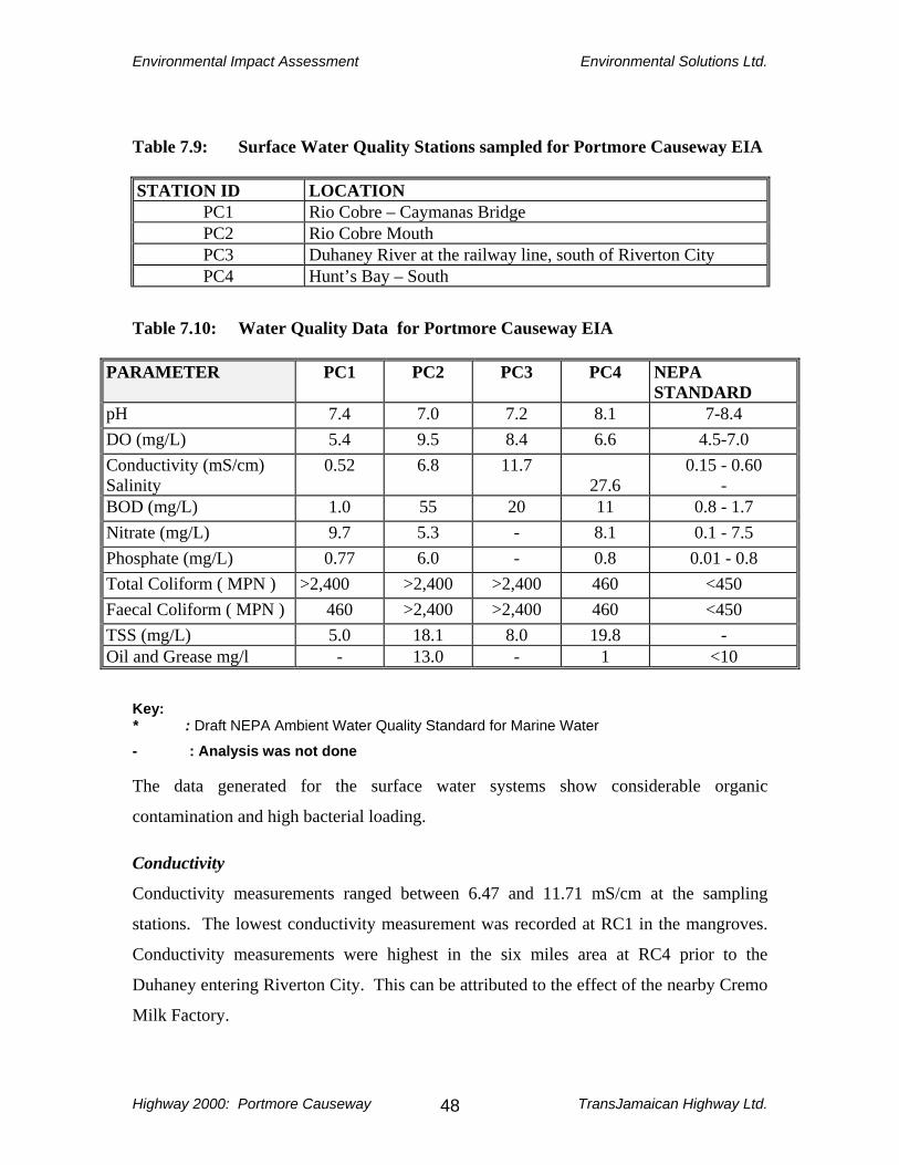
Environmental Impact Assessment Environmental Solutions Ltd.
Highway 2000: Portmore Causeway TransJamaican Highway Ltd. 48
Table 7.9: Surface Water Quality Stations sampled for Portmore Causeway EIA STATION ID LOCATION
PC1 Rio Cobre – Caymanas Bridge PC2 Rio Cobre Mouth PC3 Duhaney River at the railway line, south of Riverton City PC4 Hunt’s Bay – South
Table 7.10: Water Quality Data for Portmore Causeway EIA
PARAMETER PC1 PC2 PC3 PC4 NEPA STANDARD
pH 7.4 7.0 7.2 8.1 7-8.4 DO (mg/L) 5.4 9.5 8.4 6.6 4.5-7.0 Conductivity (mS/cm) Salinity
0.52 6.8 11.7 27.6
0.15 - 0.60 -
BOD (mg/L) 1.0 55 20 11 0.8 - 1.7 Nitrate (mg/L) 9.7 5.3 - 8.1 0.1 - 7.5 Phosphate (mg/L) 0.77 6.0 - 0.8 0.01 - 0.8 Total Coliform ( MPN ) >2,400 >2,400 >2,400 460 <450 Faecal Coliform ( MPN ) 460 >2,400 >2,400 460 <450 TSS (mg/L) 5.0 18.1 8.0 19.8 - Oil and Grease mg/l - 13.0 - 1 <10
Key: * : Draft NEPA Ambient Water Quality Standard for Marine Water
- : Analysis was not done The data generated for the surface water systems show considerable organic
contamination and high bacterial loading. Conductivity
Conductivity measurements ranged between 6.47 and 11.71 mS/cm at the sampling
stations. The lowest conductivity measurement was recorded at RC1 in the mangroves.
Conductivity measurements were highest in the six miles area at RC4 prior to the
Duhaney entering Riverton City. This can be attributed to the effect of the nearby Cremo
Milk Factory.

Environmental Impact Assessment Environmental Solutions Ltd.
Highway 2000: Portmore Causeway TransJamaican Highway Ltd. 49
Dissolved Oxygen Dissolved oxygen levels varied considerably at the water quality stations. Dissolved
oxygen levels were supersaturated at Stations PC2 and PC3. High oxygen levels at these
stations are most likely attributable to the algal blooms present at these sites at the time of
measurement.
pH
The waters at all four stations sampled were neutral (at or just above 7 pH units), or
slightly alkaline.
Biochemical Oxygen Demand (BOD5)
BOD for surface waters in excess of 2.0 mg/l indicates elevated organic loading, which is
a cause for concern. BOD levels were elevated at Stations PC2, PC3 and PC4 (no data is
available for PC5) ranging between 11 and 55 mg/l, 10 – 50 times the national guideline.
High BOD levels are a direct consequence of the high concentration of oxygen
demanding species in the surface waters. Total and Faecal Coliform Bacteria Fecal Coliform is used as indicators of the possible presence of pathogenic organisms.
The generally accepted limit for fecal coliform in surface waters is 200 MPN/100 ml. A
guideline of 450 MPN/100 ml is used for one off samples. This limit has been exceeded
at all stations, and significantly so at two stations, where levels were in excess of 2,400
MPN/100ml. Sewage effluent from several sewage treatment facilities, as well as raw
sewage from residences without sanitary facilities is discharged into these surface water
systems. It is well known that many of these treatment plants are not operating
efficiently and are discharging untreated sewage effluent into the surface water systems.
These activities are the probable cause of the high faecal coliforms present in the surface
water systems.

Environmental Impact Assessment Environmental Solutions Ltd.
Highway 2000: Portmore Causeway TransJamaican Highway Ltd. 50
Total Suspended Solids (TSS)
The Duhaney River and Rio Cobre River (particularly at its mouth) contained a large
quantity of debris consisting of plastic bags, metal pieces, logs, etc. Total Suspended
Solids loading at the water quality stations ranged between 5 and 20 mg/l. The water was
murky and visibility was poor.
Oil and Grease
Oil and grease data are available for two sites, PC2 and PC4. Oil and grease levels at
PC4 is low whereas the level at PC2 is elevated, higher than the industrial effluent
standard of 10 mg/l.
7.2 BIOLOGICAL ENVIRONMENT
7.2.1 Flora The terrestrial vegetation in the areas along the proposed alignment is dominated by
modified vegetative communities particularly scrubland as defined by Grossman et al,
(1991). This includes coastal vegetation (Plates 2 and 3) and terrestrial adjacent to the
dyke road, and fringing areas of development (Plates 4 and 5).
7.2.2 Fauna The area of the Portmore Causeway is bordered by Hunt’s Bay to the north and Kingston
Harbour to the south. Immediately east and west, are the Industrial Zone and residential
areas of the Kingston Metropolitan Area and Portmore, respectively. Seabird species
were observed and recorded, due to the proposed alignment, through wetland areas and
across the Hunt’s Bay.

Environmental Impact Assessment Environmental Solutions Ltd.
Highway 2000: Portmore Causeway TransJamaican Highway Ltd. 51
A study by Douglas (2003) on the seabirds in Kingston Harbour and adjoining areas
revealed nine species of true seabirds, in addition to other species such as ibises, rails,
herons and egrets. True seabirds were described as those birds that spend relatively large
portions of their time over the seawaters and which are only rarely (if ever) recorded on
dry land outside of the breeding season. The nine species of seabirds and other birds
observed by Douglas (2003), in the Kingston Harbour area are given in Table 7.11.
Additional information on these species including scientific name, habitat, and range
have been included based on Downer and Sutton (1990); Bull and Farrand Jr (1977); and
Bond (1985), to provide complete ecological information for these species. Other species
that have been observed in the area as part of this study have also been included.

EIA Report Environmental Solutions Ltd.
Highway 2000: Portmore Causeway TransJamaican Highway Ltd. 52
Table 7.11 Bird Species reported from the Kingston Harbour area by Douglas (2003)(*) and observed in field surveys
Common Name Scientific Name Status Range Habitat
Laughing Gull * Larus Gull Common resident Coasts of N. America, West Indies and northern S. America
Coasts and in harbours
Royal Tern* Sterna maxima Common resident Throughout the West Indies, C and S. North America, coast of W. Africa
Along coasts
Sandwich Tern* Sterna sandvicensis Common winter visitor
N. C and northern S. America, British isles and Europe
Along coasts and coastal ponds
Least Tern* Sterna antillarum Common summer resident
Worldwide Nesting on salt ponds and beaches
Brown Pelican* Pelicanus occidentalis Common resident Subspecies P.o. occidentalis in the West Indies. Also coastal N., C. and S. America
In coastal waters, on reservoirs, fish farms and in marshy areas
Magnificent Frigate Bird* Fregata magnificens Common resident Subspecies F.m. magnificens in the West Indies. Also tropical oceans around the Americas.
Often seen over fishing beaches
Ring-billed Gull* Larus delawarensis Common resident Costs of N. America, West Indies and northern S. America
On coasts and in harbours
Herring Gull* Larus argentatus Vagrant or rare transient
Common in the N. Atlantic but rare in the West Indies
Harbours
Brown Booby* Sula leucogaster Locally common resident
Subspecies S.l. leucogaster in the West Indies. Also pantropical.
On cays or at sea, immatures on coastal beaches
White Ibis Eudocimus albus Uncommon resident Greater Antilles, N. and S. America
In mangroves
Clapper Rail Rallus longirostris Uncommon resident Subspecies R.l. caribaeus in the Greater Antilles and Virgin Islands. Also C. and S. America, Bahamas and WI islands.
In mangrove roots, marsh grasses and rushes
Great Blue Heron Ardea herodias Common winter N. America, wintering in the WI In wetlands

EIA Report Environmental Solutions Ltd.
Highway 2000: Portmore Causeway TransJamaican Highway Ltd. 53
visitor and C. America south to northern S. America
Little Blue Heron Egretta caerulea Common resident Bahamas, WI and the Americas In wetlands Great Egret Casmerodius albus Common resident Subspecies C.a.egretta in the
Bahamas and Greater Antilles. Also worldwide
In wetlands
Cattle Egret Bubulcus ibis Very common resident
Worldwide Pastures and open areas
Black-Crowned Night heron
Nycticorax nycticorax Fairly common resident
Subspecies N.n. hoactli in the Antilles. Worldwide except Australia.
Beaches and in wetlands
Yellow-Crowned Night Heron
Nycticorax violaceus Common resident Subspecies N.v. bancrofti in the WI and C. America. Other races in C and S America.
Beaches and in wetlands

EIA Report Environmental Solutions Ltd.
Highway 2000: Portmore Causeway TransJamaican Highway Ltd.
54
Douglas (2003) concludes that Kingston Harbour is an important area for a number of
wintering seabirds, and the numbers of individuals vary dramatically throughout the year
with the highest numbers recorded in winter for all species. The numbers of the Brown
Pelican changed relatively little throughout the year, but Laughing Gulls and Terns were
most abundant in the winter. Kingston Harbour is important as a feeding, nesting and
roosting site for the Caribbean Brown Pelican – which is now listed as endangered
(Douglas 2003).
Based on studies by Sutton and Hay (2003) twenty-three species of resident and
migratory ducks have been recorded in Jamaica but little is known of their status or
distribution. One species, the West Indian Whistling Duck Dendrocygna arborea, is
internationally classified as vulnerable. Kingston Harbour and its environs are known
habitats for several species of resident and migratory ducks.
The American Crocodile (Crocodylus acutus) is native to Jamaica and is protected under
both national and international legislation. Known habitats include the southern
drainages of the island, which include the Rio Cobre, as well as the mangrove habitats of
the Kingston Harbour. The Waterford Canal, which will be crossed by the Highway also
has crocodiles and they are usually sighted by residents in the early morning and
afternoon hours.
7.2.3 Wetlands Mangroves exist along sections of the proposed alignment as shown in Figure 2.1 and
Plates 6, 7 and 8. The Skeet Club (Plates 2 and 3) located in the mangroves by Dawkins
Pond provides a habitat for several species of waders and shore birds (See Table 7.11).
Approximately 60% of the lands in the Skeet Club will be utilized for the highway
alignment. The dominant species is the Black Mangrove (Avicennia germinans) with the
aerial roots or pneumatophores visible, on both sides of the existing road.

EIA Report Environmental Solutions Ltd.
Highway 2000: Portmore Causeway TransJamaican Highway Ltd.
55
7.2.4 Marine Environment Hunt’s Bay is a small bay connected to the north-west of the Kingston Harbour. The Bay
receives inflows from three major sources the Rio Cobre, the Duhaney River and the
Sandy Gully (Figure 7.1), as well as six minor gullies including the Jew Gully in the
north eastern section. Inflows into Hunt’s Bay (Section 7.1.2) carry sediment, solid
waste, industrial effluent, sewage effluent and non-point source chemical pollutants.
Filling will be required in the wetlands between Dawkin’s Pond and Hunt’s Bay. The
channel that existed between Hunt’s Bay and Dawkins was closed following a
Governmental decision in 1978. The construction of the proposed Highway will therefore
not be responsible for the closure of this channel and filling in the area will not adversely
affect any flow between the two water bodies, as flow is non-existent at this point. An
aerial photograph of this area is given in Plate 9. Details related to this closure are given
in Appendix IV.
7.3 SOCIAL ENVIRONMENT
Analysis of the social environment of the Portmore Causeway segment of Highway 2000
must take account of the characteristics of the project site as well as the service areas of
the project, in that the causeway serves as the main access route between the business
districts of the Kingston Metropolitan Area (KMA) and the residential and commercial
areas southwest of the KMA. The Port of Kingston and its related operations, the
Tinson Pen aerodrome, transportation hubs, commercial, retail and wholesale
enterprises, industrial plants, boating, fishing, and residential settlements all form part of
the social setting of the project.

EIA Report Environmental Solutions Ltd.
Highway 2000: Portmore Causeway TransJamaican Highway Ltd.
56
7.3.1 Housing Settlements Settlement within the project area is dominated by the Causeway fishing village, but the
residential areas of Portmore, Greater Portmore, Hellshire, Braeton and Port Henderson,
(Figure 7.7 and Plate 6) all with their respective housing subdivisions and support
services, are significant to the project in that it is the growing population in these areas
which has created the demand for an upgraded arterial link to the KMA.
The Hellshire Bay Development Co. was established under the aegis of the Urban
Development Corporation (UDC) in 1969 with a mandate to develop a new town which
would stimulate development in a westward direction from Kingston helping to absorb
some of the growing population of the KMA which was due primarily to in-migration
from rural areas and the adjacent parish of St Catherine. Tourism development was
integral to the Hellshire Hills development, which was designed to include Hellshire Bay
New Town, Manatee Bay Development and the Central Highlands New Town. It was
projected that the Hellshire Development would accommodate up to 450,000 persons.
The Portmore Land Development Co. Ltd. was formed by private enterprise and had as
its main objective development of housing on the plains of southern St Catherine. The
flood vulnerability of the proposed development area was reduced by construction of an
eleven-mile dyke which controlled the floodway of the lower Rio Cobre, and land within
the Rio Cobre delta was reclaimed by dredging to elevate the area above inundation
levels. A three-mile causeway was built to facilitate transport connection between the
proposed development area and downtown Kingston, through Newport West - the
general cargo wharf area of the Port of Kingston.
The first housing development – Independence City - consisting of 1,000 two and three-
bedroom units was constructed in 1969. Edgewater (Plate 6), Bridgeport Phases 1, 2 and
3, Passage Fort and Waterford were constructed by 1976. Portsmouth and Southboro
followed between 1978 and 1979, and in the 1980s Westchester, Cumberland, and

EIA Report Environmental Solutions Ltd.
Highway 2000: Portmore Causeway TransJamaican Highway Ltd.
57
Westbay were completed. By mid 1990s additional developments occurred in Westbay
and Cumberland and Bridgeview was constructed. These areas are collectively referred
to as Old Portmore.
Greater Portmore led to a gigantic leap in settlement in that 16,000 units were constructed
west of and adjacent to Old Portmore on approximately 1300 acres. Additional units are
being constructed on an adjacent 93 acre tract. Yet another 2,000 unit development was
executed as Braeton New Town on approximately 1400 acres south of Old Portmore.
“Portmore” is the collective name given to the entire area which has functioned as a
dormitory settlement of the KMA on which it depends for employment, commercial and
administrative functions (Figure 7.1).
7.3.2 Zoning and Land Acquisition Zoning is not an issue as the proposed alignment will traverse an existing transportation
corridor. However, there will be a minor variation to the existing roadway as the
proposed alignment will travel along the Dyke Road, through the gates of the existing
Jam World Entertainment Centre (Plate 10), and cross the Waterford Canal with a newly
constructed bridge, before rejoining the existing alignment in the region of Dawkins
Pond.

EIA Report Environmental Solutions Ltd.
Highway 2000: Portmore Causeway TransJamaican Highway Ltd.
58
With respect to land acquisition, NROCC is the agency responsible for all issues related
to land acquisition. The lands in this area are 100% public lands under the jurisdiction of
the Commissioner of Lands. Negotiations for land acquisitions are now complete (Pers.
Com., NROCC, March 2003).
7.3.3 Land Use and Municipal Status 7.3.3.1 The Road
The Causeway is a transportation corridor which includes a causeway bridge that
traverses the Kingston Harbour in the vicinity of Hunt’s Bay. The bridge separates the
Causeway into Causeway north and Causeway south. On Causeway south there is a
thriving fishing village regarded as an “informal settlement”. The village has a
combination of accommodation units, vending areas, gear sheds, and beaching facilities
for boats.
7.3.3.2 The Port
Causeway north is dominated by the operations of the Port of Kingston. The Port of
Kingston occupies Kingston Harbour and accommodates the major general cargo port
and container terminal for Jamaica, and transshipment port for the subregion. All the
services associated with port operations such as berthing, warehousing, cargo clearance
and distribution, trucking, government agencies and others, are found in the area of Port
Bustamante. In addition the eastern section of the Harbour accommodates berthing
operations for oil tankers, wheat, cement, and gypsum.
The Port is a major economic unit and plays a substantial role in the island’s economy, as
Jamaica is perfectly placed as a transshipment port. Shipping is reported to occupy the
largest percentage of the Kingston Harbour coast (20%) while the contribution of
shipping to the national economy (of activities in the Kingston Harbour area) is given as
45% (Bacon et al, 1988). Port expansion has been on-going and has included widening
of the ships channel, facilitated by cutting of a coral cay, as well as land reclamation
works for berthing facilities and container transshipment. Reclamation works have
EIA Report Environmental Solutions Ltd.
Highway 2000: Portmore Causeway TransJamaican Highway Ltd.
59
changed the shoreline in the north east of Hunt’s Bay which has influenced the alignment
of the proposed Highway 2000 Causeway Upgrading (Plate 11), as the Highway cannot
bisect the Port Authority’s property and operations, and must be aligned along the
perimeter of the newly reclaimed area.
A small marina sits adjacent to the port operations in the southeastern corner of the
Causeway on approximately 1 acre of landfill. Boat cleaning and other maintenance
services are offered from the marina, and a dredging operation is based there.
On Marcus Garvey Drive, the Free Zone with several manufacturing/service uses is a
major use. There is also an abandoned zinc factory.
Within Kingston Harbour are several fishing beaches as discussed in Sections 7.3.6 and
7.3.7.
The Causeway is linked to Kingston via Marcus Garvey Drive and Hagley Park Road,
and at the three mile interchange Spanish Town road joins the intersection (Figure 7.1).
A significant use on Marcus Garvey Drive just north of the Causeway intersection is the
Tinson Pen aerodrome, and flight safety envelopes have been considered in the design
and siting of the alignment, and particularly the interchange.
7.3.3.3 Portmore
Portmore received Municipal status by legislation in 2002 and the new “city” includes the
area extending southwest- northeast from the coast around through the Hellshire Hills
toward the intersection with Nelson Mandela Highway in the north (Figure 7.7). As of
June 2003, the municipality is governed by a Municipal Council, led by a Mayor, which
has the power to regulate and manage solid waste, and in particular garbage collection
and street sweeping (subject to the National Solid Waste Management Act of 2000);
street lighting; the Local Planning Authority; beautification; disaster management; and
municipal amenities and facilities. The power to regulate the Local Building Authority is
shared with the St. Catherine Parish Council. The Portmore municipality lies within the

EIA Report Environmental Solutions Ltd.
Highway 2000: Portmore Causeway TransJamaican Highway Ltd.
60
parish of St Catherine and therefore falls within the jurisdiction of the St. Catherine
Parish Council, as outlined by law.
Land use in the Portmore municipality is primarily residential with commercial support
services (Plates 12 and 13). There are still large tracts of agricultural land much of which
is under utilized or abandoned. The road network was designed to support the residential
subdivisions in that there are main arteries with internal networks.
The Augusta Drive area accommodates both residential and commercial uses, and the
southern side along Port Henderson Beach is an active recreational area.
Drainage canals are integral to the landscape and these are interconnected to lead
stormwater from the interior to the coastal wetlands and shoreline.
7.3.3.4 Surrounding Land Use/Commercial Environs
The existing Causeway alignment intersects Marcus Garvey Drive, which runs east to
west from downtown Kingston, to the three mile intersection where it joins Spanish
Town and Hagley Park Roads. An industry lined thoroughfare linking downtown
Kingston with major areas of the Kingston Metropolitan Area, Marcus Garvey Drive is a
high density traffic corridor for entering and leaving the city, particularly during the early
morning and late afternoon peak periods.
Jamaica’s Oil refinery, Petrojam, is located along Marcus Garvey Drive and three
petroleum based industries are located within relatively short distances of the refinery.
Hunt’s Bay Power Station operated by The Jamaica Public Service Co. Ltd, which is
based on oil fired generators; the Esso Standard Oil SA Ltd. corporate office and storage
facility; and the plant and loading facilities of The Petroleum Company of Jamaica
(PETCOM) which is one of the local petroleum marketing companies. These petroleum-
based companies collectively comprise Jamaica’s largest infrastructure of petroleum
storage capacity and collectively employ at these locations several hundred persons.

EIA Report Environmental Solutions Ltd.
Highway 2000: Portmore Causeway TransJamaican Highway Ltd.
61
The three mile intersection is an important transportation node linking the Marcus
Garvey/Port area with Spanish Town Road leading into Mandela Highway and ultimately
Spanish Town.
Spanish Town Road is heavily commercialized with retail and wholesale establishments,
traditional industrial plants, some low-income residential areas, transport establishments
and the major landfill for the KMA, St. Catherine and Clarendon.
Hagley Park Road leading into Half-Way Tree is also heavily commercialized with
mixed use including old residential, light industrial, commercial, institutional, public
offices and recreational activities.
7.3.4 Traffic, Transportation and Access Roads
Based on studies by NROCC (NROCC, Pers. Com) an average of 37,000 vehicles use the
Portmore Causeway each day for travel to and from the downtown Kingston area, and
other parts of the KMA. Travel is mainly for work, commercial undertakings and
personal reasons. The high demand and resulting traffic congestion over the years has
resulted in a restriction in directional flow. Traffic flows one-way, easterly into the city
of Kingston in the morning peak hours (6:00 – 9:00 am), and one-way westerly into
Portmore in the afternoon peak hours (4:00 – 7:00 pm).
The high demand for traffic access stimulated the demand for upgrading which is the
subject of this EIA.
Livelihood opportunities are growing within the wider Portmore area, but the jobs are
essentially in the KMA. The Portmore area is also connected via Dawkins Drive to the
Mandela Highway from which junction, traffic flows primarily east into Kingston.
(Figure 7.7). During the upgrading of access roads as well as construction of the new
bridge, this main transportation artery must remain accessible.

EIA Report Environmental Solutions Ltd.
Highway 2000: Portmore Causeway TransJamaican Highway Ltd.
62
7.3.5 Demographics A study by the Social Development Commission (SDC) in 2002 revealed a total of 103
shacks (or camps as called by the fisherfolk) on the seaward side of the Causeway bridge
and 34 shacks on the northern side. Approximately 1300 fisherfolk currently utilize the
areas (Social Development Comission, 2002) although the SDC has listed 160 fisherfolk
with ID’s and 95 residents (in 17 families) living at the Causeway Fishing Beach.
Table 7.12 details the number of fisherfolk, vendors and families. Table 7.12 Fisherfolk, Vendors and Families at the Causeway Fishing Beach
Type of Resident Number Fisherfolk and Vendors 95 Number of Families 17 Total Vendors (non-residents) 46 Total Fisherfolk (non-residents) 53 (Source: Social Development Commission, 2000) Daily population peaks would be achieved by influx of workers to the Port and Freezone
areas on the eastern end of the Causeway.
Approximately 250,000 persons reside in the Portmore community, where there are about
62,000 housing units. This figure reflects the population explosion that has occurred since
1970 when the population was about 2,200. This increase has resulted from the planned
residential development which accompanied the policy of Portmore’s establishment as a
growth center, and the increasing demand for housing in the KMA and Spanish Town
areas.
The school age population (5-19) is approximately 25% of the total, and the working age
group (20-59) amounts to around 56%. The 0-4 and >60 age cohorts complete the
remaining 19% (extrapolated from Census 2001). Demand for transportation and
services is therefore high, given the structure of the population.
EIA Report Environmental Solutions Ltd.
Highway 2000: Portmore Causeway TransJamaican Highway Ltd.
63
7.3.6 Livelihoods Livelihoods in the project area include the Causeway itself, the Portmore municipality,
the Port of Kingston and environs, the Kingston Harbour/Hunt’s Bay area, and the KMA.
7.3.6.1 Fishing
The Portmore Causeway was completed in the late 1960’s, and at that time a number of
Kingston Harbour fisherfolk who had been operating from beaches along the northern
rim of Hunt’s Bay, moved southward to find themselves more convenient bases inside
Hunt’s Bay along the shoreline of the causeway embankment. The move was inspired in
the first instance by a sense of isolation created by the Causeway, and later (1979/80)
additional fisherfolk moved to escape from political violence in western Kingston (Social
Development Commission, 2000). By the end of the 1970s the practice of landing the
catch inside Hunt’s Bay along the causeway embankment, just south of the new bridge,
had become firmly entrenched, and fisherfolk began to attract much patronage selling
directly from their boats, to passing commuters between Kingston and the rapidly
expanding Portmore.
Over the past two decades fish vending along the causeway has increased, to the extent
that at times, especially on weekends, a section of the main road near the bridge has
become a drive-through fish market with patrons coming from both the Kingston and
Portmore side. Over the years, this continually worsening situation has attracted
considerable adverse public comment, but despite several announcements regarding the
need to address the critical environmental issues that have been generated (public health,
sanitation, traffic hazards, visual aesthetics), the colony of fishers and vendors has
continued to flourish. The quarter mile stretch of the Causeway on the Portmore side of
the bridge, is lined on both shoulders with clusters of unsightly shacks which serve as
shops and dwelling units for both fishers and vendors.
Recent data provided by the Fisheries Division (Environmental Solutions Ltd, 2002)
indicates that the Causeway/Hunt’s Bay location has some 734 registered fishermen.
Fishing is undertaken in Hunt’s Bay, Kingston Harbour, on the Pedro Banks, St. Thomas

EIA Report Environmental Solutions Ltd.
Highway 2000: Portmore Causeway TransJamaican Highway Ltd.
64
and as far west as St. Elizabeth. In 1996 the population of boats berthed on the Causeway
was a modest 25 to 40 although an additional small number were kept at Dawkins Pond
nearby. The Fisheries Division (Environmental Solutions Ltd., 2002) reports
approximately 103 boats on the Causeway beach, but a recent report (Environmental
Solutions Ltd., 2002) has reported some 146 boats counted in 2002, with 126 of these
berthed on the inside of Hunt’s Bay.
The Kingston Harbour based fishing fleet comprises both larger long distance boats and
smaller canoes. The fishing beaches licensed by the Fisheries Division in the Kingston
Harbour include Port Royal, Hunt’s Bay, Port Henderson, Passage Fort, Greenwich
Beach, Gypsum Wharf , Harbour Head, and Rockfort. The Causeway is recognized as a
beach which has been traditionally used by fisherfolk.
7.3.6.2 Portmore Residents
The Portmore population is largely a commuter population engaged in employment
mainly in Kingston and Spanish Town. Kingston and Spanish Town are two large urban
centers with the mix of occupations associated with urban areas. The KMA is the
economic and cultural hub of the island. Spanish Town as the capital of the parish of St.
Catherine has, in addition to municipal functions, retail, wholesale, industrial,
commercial and service activities. The town is densely populated and is characterized by
traffic congestion.
Spanish Town is described as part of the “Historic Triangle” of the Kingston
Metropolitan Region, which includes Kingston and Port Royal, all with significant
heritage assets that form a significant part of the tourism product.
The new Portmore municipality includes agricultural land, but most activity is “urban
centred”. The principal occupations include the many retail and commercial services
attendant on growing communities.

EIA Report Environmental Solutions Ltd.
Highway 2000: Portmore Causeway TransJamaican Highway Ltd.
65
7.3.7 Relocation Requirements
Fisherfolk are currently illegally occupying Government-owned lands within the
proposed right-of-way along the Causeway (See sections 7.3.4 and 7.3.6). NROCC, as
the Grantor, is responsible for land acquisition, and for the provision of a corridor free of
encumbrances to the Developer for construction of the highway, and the operation of a
limited access Toll Road.
The details of the issues relevant to relocation have been outlined to NEPA in a letter
from NROCC dated January 22, 2003 (Appendix V). There are three aspects related to
the relocation of fisherfolk along the Portmore Causeway. These are:
1) Landing Beach 2) Residence 3) Vending Landing Beach Currently the fisherfolk land their catch on the Portmore Causeway. A proposal has been
made to the Ministry of Agriculture for the provision of an alternative beach area where
the fisherfolk can land their catch. An area has been suggested by the Ministry of
Agriculture on the south west portion of Hunt’s Bay. This land is public land. The
Ministry of Agriculture would have to be responsible for all the aspects related to the
establishment of a new fishing beach. Another proposal under consideration is a shift of
the alignment between chainage 191+600 km to 192+200 km. This would then result in
the fisherfolk on the south side of the Causeway remaining there, and those on the north
side being relocated to the other side, within the fishing village. All proposals are still
under consideration.

EIA Report Environmental Solutions Ltd.
Highway 2000: Portmore Causeway TransJamaican Highway Ltd.
66
Residence Fisherfolk currently residing on the Portmore Causeway, if relocated completely, would
possibly be provided with the opportunity to purchase land at Portmore Villas, north of
Waterford and adjacent to the Dyke Road (in the area commonly referred to as Lesser
Portmore). Portmore Villas is already zoned as a residential area. NROCC will need to
determine how many persons would qualify to purchase land in this area. If the
alignment is shifted so that only the northern based fisherfolk are dislocated, the
relocation of the entire village, and residential options, would not need to be
implemented. All proposal are still under consideration.
Vending
Currently the fisherfolk also sell their catch from the Portmore Causeway. NROCC has
had discussions with the Portmore Foundation, which is a Non-Governmental
Organization that has identified the need for a public market facility in the area. The
Foundation has prepared a Business Plan for 2002-2006 which addresses the need for a
market in the area with a wet area for handling fish and meat. 2.89 acres of land has
already been leased for a twenty-five (25) year period, from the Urban Development
Corporation (UDC), in the Portmore Town Centre. A plan of the proposed market is
given in Appendix VI.
It is intended that NROCC will contribute to establishment of the wet area of the market
so as to accommodate fish vendors being relocated from the Causeway.
A few Fisherfolk are also situated at the mouth of the Waterford Canal, with residences
and boats landed. These Fisherfolk will also have to be relocated to facilitate the
Highway alignment.
EIA Report Environmental Solutions Ltd.
Highway 2000: Portmore Causeway TransJamaican Highway Ltd.
67
7.3.8 Community Facilities The Highway 2000 Portmore Causeway upgrading project will terminate on the Portmore
side in the vicinity of the City Centre where a major shopping mall (Plate 12), and other
retail and service activities are located. The City Center is also a transportation node.
Portmore Community College and Heart/NTA facilities are located in the general area.
Schools, churches and community centers are well represented in the Portmore
municipality.
7.3.9 Solid Waste Management Plastics, paper/cardboard, glass, and metal containers dominate the waste stream in the
project area. Waste comes from informal communities in the area, and along the fringing
mangroves waste is lodged, having been washed up from Hunt’s Bay. The waste is
washed into the bay primarily by Sandy and Jew Gullies, and other drains emptying into
the area. (Figure 7.1)
The area in the vicinity of Jew Gully in the northeastern section of Hunts Bay is virtually
stagnant and is shallow from the deposition of soft sediments and large quantities of
submerged waste – tyres, old vehicles, tree branches etc. The area is aesthetically
unpleasant and malodorous.
Solid waste generated as a result of the construction activities will be disposed of at the
Riverton City Landfill. This will include the existing causeway bridge after it is
demolished. Discussions were held with officers of the National Solid Waste
Management Authority (NSWMA) on Friday June 13th, in order to discuss issues related
to the capacity of the Riverton City Landfill to accommodate the construction waste
(Appendix II). The NSWMA has indicated that the Riverton City Landfill can
accommodate the bridge structure and other construction waste, as there are 45 hectares
of land now available (NSWMA, Pers. Com). Construction rubble without steel and
other metals, will actually be welcomed by the NSWMA, and accepted free of tipping

EIA Report Environmental Solutions Ltd.
Highway 2000: Portmore Causeway TransJamaican Highway Ltd.
68
fees, and used in the operations at the Landfill (NSWMA, Pers. Com.). Metal and other
construction rubble would be accepted with requisite charges.
7.3.10 Recreation There are no recreational areas in the immediate vicinity of the project but the Causeway
provides the main transportation link between residents of the KMA and the Hellshire
Beach and Port Henderson areas. The Port Henderson area accommodates clubs and
restaurants, while Hellshire and Fort Clarence provide bathing beach facilities. The
JamWorld Entertainment Centre on Dyke Road has not been in use for many years.
7.3.11 Archaeological and Cultural Heritage Two listed sites under the Jamaica National Heritage Trust Act are located in the project
area. The Site of Passage Fort (Puerto de Caguaya), site of the first port in the Kingston
Harbour, is a listed site and is located just south-south-west of the mouth of the
Waterford Canal (Figure 7.5). The Highway alignment will cross the Site of Passage
Fort. It appears that there are no visible structures located at this site, and the JNHT has
been asked to provide information on this site (Appendix VII). Fort Augusta (Figure 7.5)
is also a listed site under the Jamaica National Heritage Trust Act. The Fort is currently
used as a Women’s Prison. Highway 2000 will not impact Fort Augusta.
Port Henderson, a former fortification also during the British period of history, is located
in the project area. Port Royal, Spanish Town and Kingston together form the Historic
Triangle in Jamaica.

EIA Report Environmental Solutions Ltd.
Highway 2000: Portmore Causeway TransJamaican Highway Ltd.
69
8.0 CONSIDERATION OF ALTERNATIVES 8.1 ALIGNMENT
Other options for the alignment for the Portmore Causeway section of Highway 2000
have been considered.
1. The plans for the expansion of the Port of Kingston operations required an
increase in land space for the Kingston Container Terminal. This has been achieved by
reclaiming a section of Hunt’s Bay on the western side of the originally proposed
alignment of the Portmore Causeway and in the north eastern part of Hunt’s Bay (Plate
11). The alignment as originally designed would have resulted in the container terminal’s
operation being divided by the highway’s six-lane dual-carriageway. The Port Authority
land reclamation is now complete in the north eastern part of Hunt’s Bay.
Given the completion of the PAJ’s reclamation programme the Highway alignment was
reconsidered, at the request of the Port Authority of Jamaica, to run along the western
perimeter of the Port Authority’s reclaimed area. Suitable access to the Port Authority’s
facilities has been discussed, between NROCC and the Port Authority.
2. The Jamaica Institute of Engineers (JIE) (Farquarhson Institute of Public Affairs,
2001) in their viewpoint on Highway 2000 raised some specific issue with regard to
alignment of the Portmore Causeway section. The JIE proposed an interchange at Six
Miles, to pick up traffic from Kingston, rather than further west on the Mandela Highway
at Caymanas in the vicinity of the Rio Cobre Bridge. From Six Miles the JIE proposal is
for the alignment to run west-south-westerly connecting at the Greater Portmore
Intersection (Figure 8.1).

EIA Report Environmental Solutions Ltd.
Highway 2000: Portmore Causeway TransJamaican Highway Ltd.
70
From the JIE’s point of view, this would be more feasible in routing traffic from
Kingston onto the Highway. The JIE sees the inclusion of the Portmore Causeway in the
Highway 2000 Project as a means of ensuring toll revenue from the citizens of Portmore.
Revenue is a critical component of the cost-benefit for the Highway 2000 Project, and the
JIE feels that the interests of the citizens of Portmore have been betrayed. The JIE
realises the need for upgrading of the existing Causeway bridge, but feels that this
upgrade should be undertaken separately by the Government of Jamaica, and should not
be included in the Highway 2000 toll project.
The decision of the alignment of the Toll Road must take into account social, financial
and other aspects. The interests of the citizens of Portmore has not been compromised as
there will remain a non-tolled route as dictated under the Toll Roads Act of 2002.
The alignment as proposed by the JIE is along the northern boundary of the Riverton City
dump, which would limit any proposed expansion of the landfill in this direction.
3. No alternatives to the alignment along Dyke Road, Dawkins Drive, nor along the
existing Causeway Bridge have been proposed by any other entity.
8.2 BRIDGE DESIGN
8.2.1 Bridge Span and Design
The existing bridge approach is just above sea-level (Plate 14) and the bridge has a
clearance of 8.75 m. This has resulted in a very distinct hump on the bridge (Plate 15),
which reduces long range visibility and has been the cause of many traffic accidents.
The design of the proposed new Causeway Bridge is given in Figure 8.2. The design
includes raising the bridge approaches some 5m, while maintaining the same clearance.
This will result in ‘flattening’ the bridge and reducing the existing ‘hump’. The vertical
alignment of the bridge will be designed in accordance with the design speed of the
Highway.

EIA Report Environmental Solutions Ltd.
Highway 2000: Portmore Causeway TransJamaican Highway Ltd.
71
The bridge span has been an issue of considerable debate over the years since its
construction. The creation of the solid fill Causeway and the bridge resulted in a
narrowing of the connection between the two water bodies (Hunt’s Bay and Kingston
Harbour), which has significantly reduced the flow between them, resulting in continued
deterioration of water quality and ecological conditions in the Bay. This has also resulted
in a ‘jet-stream’ effect of material passing from Hunt’s Bay into the Harbour.
In a letter to the Environmental Solutions Ltd. regarding consultations on the bridge span,
Mr. Cowell Lyn, a Coastal Engineer and Project co-ordinator for the Kingston Harbour
Rehabilitation Project (administered by the National Environment and Planning Agency
and funded by the Inter-American Development Bank) stated although it might be
possible to increase the span of the bridge, he did not think “that such concessions would
be likely to restore, to any worthwhile extent, the original productive functions of the
Bay” (Appendix IX). Of greater importance is the cross-sectional area under the bridge
so that the “channel could be either wide and shallow or narrow and deep – so long as it
would let out the design flood flow without scouring the footings of the bridge piers”.
The design of the proposed new Causeway Bridge does not impact on the width and
depth of the existing channel. In fact the new bridge is marginally wider than the existing
bridge, and has one less pier than the existing, which represents one less obstructive unit
to the flow.
It should be noted that the main issues related to the continued deterioration of Hunt’s
Bay are based on continued polluted inflows, which must be stemmed if any
improvement in the condition of the Bay is to be achieved.
In addition to the physical and ecological considerations regarding the span of the bridge,
it should also be noted that the cost of increasing the span of the bridge, from the existing
700 ft span to 1,200 ft. would cost approximately US$10 million (BYTPJ, Pers. Com.).
The arrangements under the Highway 2000 project are based on a fixed-price contract

EIA Report Environmental Solutions Ltd.
Highway 2000: Portmore Causeway TransJamaican Highway Ltd.
72
and this additional cost could not be borne by the Developer or the Contractor, but would
have to be borne by an entity outside the highway 2000 Project.
8.2.2 Bridge Location The Jamaica Institute of Engineers had also recommended that the new bridge be sited
further west, which would allow more land to the east for continued expansion of the Port
Authority’s facilities. This would then place the bridge more in line with the flow from
the Rio Cobre and the Sandy Gully, which would naturally improving the flushing
potential of Hunt’s Bay (Appendix X).
8.3 CONSTRUCTION CAMP
The Construction Camp Site currently in operation for other segments of Highway 2000
is located at Bodles in St. Catherine. However, this site cannot be used for the Portmore
Causeway section as it would result in high costs for transportation of material.
Option 1:
An option for the Construction Camp Site was the PAJ’s newly reclaimed area at
Newport West in the north eastern section of Hunt’s Bay. This site was not considered
feasible as it is at the eastern-most extremity of the alignment and would involve high
transportation costs to the western end of the alignment in the Christian Pen area (Figure
2.1). However, this site is still proposed to be used for possible stockpile of dredge
material to be utilised in the Highway construction.
Option 2:
A second option for the Construction Camp Site is the Jam World site located between
the Dyke Road and the Rio Cobre. This site is centrally located with regard to the
Highway alignment, and has adequate space. The Commissioner of Lands has approved
the use of this area for the Highway 2000 Construction Camp (Appendix X). However,
this location is in the floodway of the canalised Rio Cobre, near the river mouth, and is
prone to flooding. This is the preferred option of the Contractor. However, the
EIA Report Environmental Solutions Ltd.
Highway 2000: Portmore Causeway TransJamaican Highway Ltd.
73
Contractor has indicated their intent to raise the base of structures approximately 1m
above the existing level and the construct a small dyke.
Option 3:
A third option, that was considered is the newly reclaimed Port Authority land at Fort
Augusta (Figure 7.8). The Port Authority has begun filling in the area between the
existing road and the Fort Augusta Road, which will be included in the Port of Kingston
expansion facilities. This area is centrally located with respect to the alignment, is
undergoing a period of consolidation, and it is proposed that some of this land be utilised
by the Highway for the construction of the 21-lane toll plaza.
8.4 SOURCING OF MATERIALS
Earth materials for the Highway construction currently underway (Old Harbour Bypass
Dualization and Kingston to Bushy Park) are obtained from the Hill Run Quarry in St.
Catherine (Plate 16). Bouygues Travaux Publics Jamaican Branch will continue to utilise
the Hill Run Quarry for construction of the Portmore Causeway segment, but additional
material sources may also be required. Several options have been explored for
additional earth materials.
Option 1:
Dredging of sea sand from an area south of the Palisadoes Spit was considered.
Discussions were held with NEPA to determine the feasibility of this option and
permitting requirements. However, the costs for dredging in the deep sea and
transportation to shore, proved prohibitive, and this option is no longer under
consideration.
EIA Report Environmental Solutions Ltd.
Highway 2000: Portmore Causeway TransJamaican Highway Ltd.
74
Option 2:
Obtaining dredge spoil from the Port Authority’s dredging operations, which has been
disposed of just outside the Harbour mouth. This option was also discussed with NEPA
but administrative arrangements for the transfer of material are as yet unclear.
Option 3:
Dredging at the mouth of the Rio Cobre. Discussions were held with NEPA, ESL and
Bouygues Travaux Publics Jamaican Branch, the contractors for Highway 2000, on
Thursday July 3, 2003, to discuss the feasibility of this option, and permitting
requirements. However, NEPA advised that a licence had already been issued to
WIHCON Infrastructure Ltd. to carry out maintenance dredging in this area, in
association with the National Works Agency, and it would not be practical or feasible to
issue another licence to dredge in the same area.
Option 4:
Obtaining dredge spoil from the approved maintenance dredging project for Hunt’s Bay.
This work is being undertaken by the National Works Agency with WIHCON
Infrastructure Ltd. as the contractors, and will involve the removal of 2,000,000 cubic
metres of material. This dredging began in July 2003, under a license from NEPA, to
dredge the portion of the floor of the sea at Hunt’s Bay, at the mouths of the Sandy Gully,
the Duhaney River and the Rio Cobre. Dredging works are expected to end in March
2004.
The contractor for Highway 2000 (Bouygues Travaux Publics) has had discussions with
NEPA and WIHCON to determine the protocol for utilising some of this material. This
option appears to be the most feasible, and NEPA has agreed in principle to the use of
this dredge spoil for the Highway construction, at a meeting held on Thursday July 3,
2003 (NEPA, BYTPJ, TJH, ESL). Discussions have been held between Bouygues
Travaux Publics and WIHCON to determine the protocol for acquisition of the dredge
material. However, NEPA has stated that the main constraint to this option is the

EIA Report Environmental Solutions Ltd.
Highway 2000: Portmore Causeway TransJamaican Highway Ltd.
75
amendment of the license for the current dredging operations to reflect the change
in the disposal site.
8.5 No Action Alternative
The ‘No Action Alternative’ describes the situation and impacts that would occur if the
project was not implemented. If the project, as proposed is not implemented, the existing
bridge would continue to be used, exacerbating the issues related to traffic congestion and
to the demise in the structural integrity of the bridge.
Traffic Congestion One of the main concerns for the Portmore Causeway is the continued increase in traffic
as a result of the growing population in the Portmore municipality. Traffic congestion
induces motor vehicle idling which in turn wastes petrol and increases vehicular
emissions. The risk of accidents is increased and productivity reduced. A one way
system was therefore implemented on the bridge for the morning and afternoon peak
hours. This system has been beneficial but cannot be seen as a long-term solution, as
two-way movement should be restored. Two-way movement can only be restored if a
new bridge is constructed offering more lanes than currently exists.
Structural Integrity of the Bridge
The existing Causeway Bridge is now over thirty years old and was not designed to carry
the current load from the increased number of vehicles on the road, and the slow passage
of the vehicles during peak hours. Many parties have expressed concerns over the
structural integrity of the bridge and recommendations have been made for a new bridge
to be constructed before any serious damage occurs, risking passenger safety.
Alternatively, if the project is not implemented, the existing bridge would eventually
have to be closed to the motoring public if it is deemed unsafe.

EIA Report Environmental Solutions Ltd.
Highway 2000: Portmore Causeway TransJamaican Highway Ltd.
76
9.0 DETERMINATION OF POTENTIAL IMPACTS
This section identifies the potential impacts and suggested mitigation measures as related
to the Portmore Causeway segment of Highway 2000. Findings of the assessment are
presented according to site preparation, construction and operation phases. The impacts
have been determined as significant positive or negative, direct or indirect, long term or
short term. The Impact Matrix presented in Table 9.1 identifies the inter-relationships
between the project activities and the physical, biological and social environmental
factors.
As indicated in the Terms of Reference the impact analysis has placed special emphasis
on the following:
o The Alignment
o Hydrology and Drainage
o Coastal dynamics
o Bridge Construction
o Bridge Span
o Bridge Demolition
o Traffic Flow
o Location of Interchanges and Toll Plazas
o Relocation of Fisherfolk
o Sourcing, Transport and Deployment of fill Material
o Shoreline Protection Works
o Noise and Air Quality
o Loss of Wetlands
o Water Quality
o Location of Construction Camp

EIA Report Environmental Solutions Ltd.
Highway 2000: Portmore Causeway TransJamaican Highway Ltd.
77
Table 9.1 Impact Matrix

EIA Report Environmental Solutions Ltd.
Highway 2000: Portmore Causeway TransJamaican Highway Ltd.
78
Table 9.1 Impact matrix page 2

EIA Report Environmental Solutions Ltd.
Highway 2000: Portmore Causeway TransJamaican Highway Ltd.
79
Potential impacts of the entire Highway 2000 Project, and recommended mitigation
measures, were determined in the Strategic Environmental Assessment and are presented
in Appendix VIII for reference. Some of these recommendations are generic to all
sections.
9.1 ALIGNMENT
The alignment for Highway 2000 was determined using several criteria and utilising the
least constraining methodology. Optimisation of the alignment was carried out through
the consideration of alternatives during the Functional Planning stage (Government of
Jamaica, 2000 – Volume III). The selected alignment is the optimal alignment given the
physical constraints. Potential impacts and proposed mitigation measures are described
in Table 9.2.

EIA Report Environmental Solutions Ltd.
Highway 2000: Portmore Causeway TransJamaican Highway Ltd.
80
Table 9.2: Alignment - Potential Impacts and Mitigation Measures
Potential Impacts Mitigation Measures • Over gullies
The Highway crosses the Waterford Canal at 194+500.
Drainage structures have been designed to ensure
continuous flow thus preventing ponding and flooding. A
100-year return period has been used for major structures
and the overall drainage system has been designed to
accommodate flash floods and catastrophic events which
characterize the area.
• Through existing
vegetative stands
Vegetative stands are all modified vegetation including
scrubland and wasteland. There are no stands of primary
vegetation along the current alignment.
Landscaping should include trees and shrubs as appropriate
in order to maintain airshed purification functions.
• Through mangroves
The alignment will go through mangroves along the south-
western corner of Hunt’s Bay and Dawkins Pond.
Discussions should be held with NEPA to determine the
feasibility of the establishment of Wetlands Mitigation
Banking in Jamaica, or for the identification of a suitable
site or existing mangrove replanting project, into which
Highway 2000 can contribute to the re-establishment of
mangroves to replace acreage removed.

EIA Report Environmental Solutions Ltd.
Highway 2000: Portmore Causeway TransJamaican Highway Ltd.
81
• Land Acquisition
Land acquisition for the required acreage is the responsibility
of the National Roads Operating and Constructing Company
(NROCC).
The land required for the Portmore Causeway alignment is
100% Crown Lands. All negotiations between NROCC and
the Commissioner of Lands are complete (NROCC, 2003).
• Existing local roads
and access
Points have been identified where the Highway will cross or
intersect with existing local roads.
Access will be provided at the following points:
Portmore Road to access the Mandela Highway
Interchange
Dawkins Drive Interchange to facilitate access to
Portmore
Fort Augusta Interchange
Newport West Industrial Area
Marcus Garvey Interchange
• Archaeological and
cultural resources
Two sites in close proximity to the Highway alignment are
listed by the JNHT as heritage sites. These are the Site of
Passage Fort (Puerto de Caguaya) just south-south west of
the Waterford Canal and Fort Augusta, which extends into
Kingston Harbour. Fort Augusta is not expected to be
1. The Jamaica National Heritage Trust (JNHT) has
already been contacted and made aware of the
highway alignment.
2. The JNHT has been requested to provide any
additional information that they see pertinent to these
sites.
EIA Report Environmental Solutions Ltd.
Highway 2000: Portmore Causeway TransJamaican Highway Ltd.
82
impacted by the Highway construction.
3. The JNHT should be allowed to conduct a Watching
Brief during the site preparation and construction
phases, and to perform Rescue Archaeology as
appropriate.
• Coastal Filling
Coastal filling will be required to facilitate the Highway
alignment.
Filling will be required in the north east section of Hunt’s
Bay in the vicinity of several gullies that drain Cockburn
Gardens, Marcus Garvey Drive and Spanish Town Road.
This area is prone to flooding (Figure 7.1)
Filling activities can result in increased turbidity in the
coastal zone which can result in settling of earth materials on
the benthic environment.
Additionally, one area is adjacent to the recently filled Port
Authority of Jamaica area, which has resulted in an alteration
of the originally proposed alignment. The PAJ reclamation
will result in the Highway alignment extending farther west
into Hunt’s Bay than previously expected.
1. An application has already been submitted
to NEPA for a Beach Licence for foreshore
modification to conduct the filling as
required.
2. Signs must be posted facing landward and
seaward indicating that an application to
conduct foreshore modification works has
been submitted to NEPA.
3. Construction methods will consider and
minimize additional silt loading in the
coastal waters.
4. The Highway 2000 project must ensure that
the highway construction does not restrict
flow from existing drainage channels,
particularly in the north east section of
Hunt’s Bay.

EIA Report Environmental Solutions Ltd.
Highway 2000: Portmore Causeway TransJamaican Highway Ltd.
83
5. Inter-agency dialogue must be initiated in
order to resolve the issues related to
potential flooding in the north east section
of Hunts Bay.
Around the Port Authority of Jamaica’s reclaimed land
In the east of Hunt’s Bay the Port Authority of Jamaica has
completed land fill in order to expand their terminal
operations. This expansion was approved after planning for
Highway 2000 was started. The Developer now has to adjust
the alignment in this area as the Highway cannot bisect the
Port Authority’s operations. The fill was completed on top of
existing peaty substrate, which has the potential to slump as it
is not designed to have a high bearing capacity. This has
been experienced along the eastern section of the existing
causeway and has required continued maintenance (Cowell
Lyn, Pers. Com.)
The fill area in the eastern corner of Hunt’s Bay should be
removed, leveled to grade and re-filled using proper
engineering techniques suitable withstanding the load
carried by a 4-lane Highway, and for the peaty substrate.
This would include layering of geotextiles to ensure
maximum bearing capacity. This would be an initial cost,
but long term costs in continued maintenance of the
Highway, resulting from slumping of the road, could be
higher.
Crossing the Railway Line
The alignment crosses the railway in the vicinity of Chainage
197+000 on the Dyke Road (Plate 16). Recommendations
for the entire Highway 2000 project, made in the Strategic
Environmental Assessment (Development Bank of Jamaica,
2000 a-d) included the maintenance of the railway right-of-
The railway line must not be sterilized at this point and the
level crossing should remain.
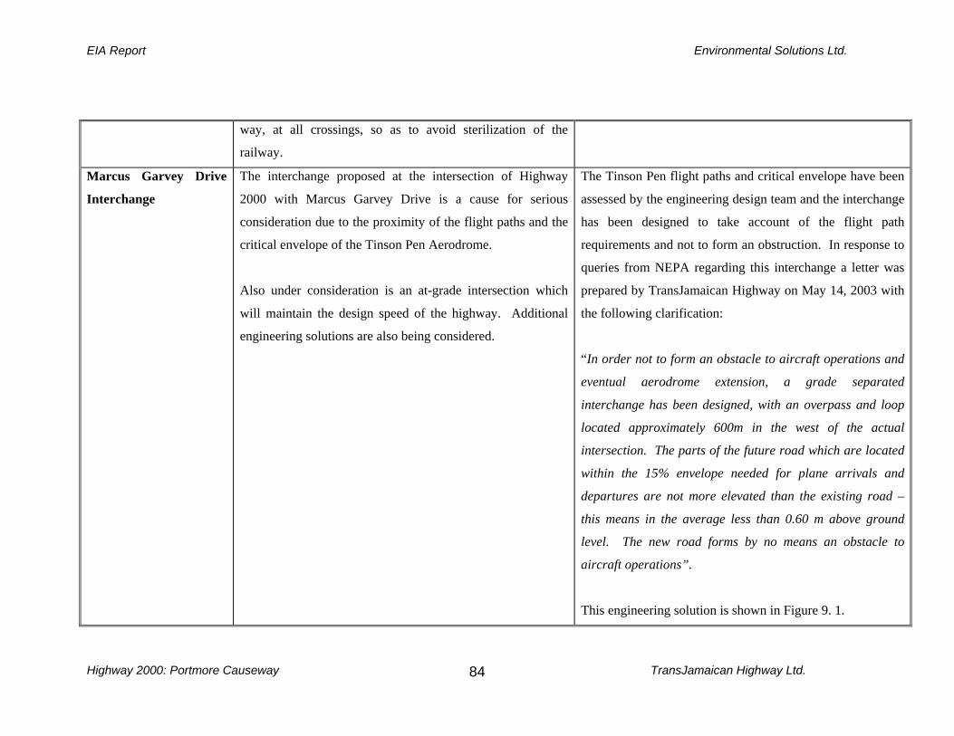
EIA Report Environmental Solutions Ltd.
Highway 2000: Portmore Causeway TransJamaican Highway Ltd.
84
way, at all crossings, so as to avoid sterilization of the
railway.
Marcus Garvey Drive
Interchange
The interchange proposed at the intersection of Highway
2000 with Marcus Garvey Drive is a cause for serious
consideration due to the proximity of the flight paths and the
critical envelope of the Tinson Pen Aerodrome.
Also under consideration is an at-grade intersection which
will maintain the design speed of the highway. Additional
engineering solutions are also being considered.
The Tinson Pen flight paths and critical envelope have been
assessed by the engineering design team and the interchange
has been designed to take account of the flight path
requirements and not to form an obstruction. In response to
queries from NEPA regarding this interchange a letter was
prepared by TransJamaican Highway on May 14, 2003 with
the following clarification:
“In order not to form an obstacle to aircraft operations and
eventual aerodrome extension, a grade separated
interchange has been designed, with an overpass and loop
located approximately 600m in the west of the actual
intersection. The parts of the future road which are located
within the 15% envelope needed for plane arrivals and
departures are not more elevated than the existing road –
this means in the average less than 0.60 m above ground
level. The new road forms by no means an obstacle to
aircraft operations”.
This engineering solution is shown in Figure 9. 1.

EIA Report Environmental Solutions Ltd.
Highway 2000: Portmore Causeway TransJamaican Highway Ltd.
85
9.2 Site Preparation Construction and Operation Phases
Table 9.3: Natural Environment – Potential Impacts and Mitigation Measures
Environmental
Aspect
Potential Impacts Mitigation Measures
Hydrology and
Drainage
Impacts on hydrology and drainage are both direct
and indirect. They relate to all phases of the
development and to high volume events (major
drainage) as well as to drainage requirements for
run-off from more frequent events (minor
drainage).
The Causeway spans the outlet of Hunt’s Bay
which receives storm run-off from several major
and minor drainage channels as described in
Section 7.1.4 and these systems require careful
engineering to avoid blockage of flow. The
natural drainage is north to south and the highway
alignment varies from east-west and north-south.
Inadequately designed hydraulic structures could
result in a negative impact to the highway,
1. Surface drainage design considers both the major and
minor systems. The major system is the route followed
when the minor system is exceeded.
2. The engineering design has used the 100-yr. event as
design criterion for major drainage, including bridge
openings, to accommodate flash floods and catastrophic
events, which typify the area.
3. Storm water runoff (more frequent events) will be handled
by curbs, channels, catch basin inlets, storm sewer\s, minor
swales and roadside ditches. These have been designed to
prevent ponding and flooding of the highway and adjacent
properties.
4. Maintenance dredging at the mouth of the Rio Cobre and
The Sandy Gully would assist in the free flow of water from
Hunt’s Bay into the Harbour and reduce build up of

EIA Report Environmental Solutions Ltd.
Highway 2000: Portmore Causeway TransJamaican Highway Ltd.
86
existing infrastructure and properties adjacent to
the highway. Direct impacts involve :
Storm channel outlets into Hunt’s
Bay
Ponding
Siltation
Pollution
Water Supply
Indirect impacts involve:
Pollution
Site Preparation and Construction Impact
A major consideration is the flow from Hunt’s
Bay into Kingston Harbour. Construction of the
Causeway Bridge over thirty years ago resulted in
restricted flow from the Bay into the Harbour,
causing semi-stagnation of the Hunt’s Bay, a
decline in shrimp and fin fisheries and increased
sediments.
The guiding principles for the design of the highway in relation to
drainage are:
All bridges and culverts over 5.0 m in total
opening width are designed to pass the 100 year
storm with a minimum freeboard of 1.0 m between
lowest point on bridge and high water level.
Culverts under 5.0 m opening width are designed
to pass 25-yr storm with minimum 600 mm
freeboard between the edge of the road and high
water level during 100-yr storm event.
Scour protection will be provided where
necessary.
Highway profiles must be consistent with major
drainage to enable free flow.
The gullies that currently run under the road must be maintained,
and design must ensure that there is no blockage of the existing
channels. In the north-eastern section of Hunt’s Bay where land
filling is required, gullies will have to be extended to ensure that

EIA Report Environmental Solutions Ltd.
Highway 2000: Portmore Causeway TransJamaican Highway Ltd.
87
sedimentation. Hunt’s Bay prior to the Causeway
played a significant role in the flushing of
Kingston Harbour. The proposed alignment runs
parallel to the Rio Cobre River along the Dyke
Road and crosses the Waterford Canal. Widening
the Dyke Road and the existing Causeway will
remove some vegetative cover and the paved
surfaces will result in the reduction of percolation
of water through the soil at the level that currently
obtains. The low-lying topography is also
currently susceptible to ponding.
their channels remain open. The two gullies to be crossed (UDC
Town Drain and the Waterford Canal) are accommodated in the
engineering design.
If these principles are adhered to, the potential for flooding, as a
consequence of the highway construction, should be negligible.
Operation Phase
During the operation phase the mitigation measures incorporated
in the engineering design should prevent problems of ponding on
the Highway. Scheduled inspections and maintenance of
drainage channels is critical.

EIA Report Environmental Solutions Ltd.
Highway 2000: Portmore Causeway TransJamaican Highway Ltd.
88
Hazard
Vulnerability
Impacts during site preparation or construction
relate to the effect of flood events and stormwater
run-off on the project as well as the effect of
activities on the ability of Hunt’s Bay and the
Harbour to accommodate storm surges and
seismic events. Flooding is a major natural
hazard to be encountered by construction of the
highway, and the major impact is derived from
the effect of extreme runoff on the site and the
low-lying nature of the topography. The area
adjacent to the Skeet Club by Dawkins Drive is
also prone to flooding.
With respect to man-made/technological hazards,
accidents can occur as a result of construction
activities directly on-site and as a result of
activities off-site, such as transportation of
equipment and materials.
Storm surge is also a risk as the alignment crosses
the Kingston Harbour.
Health and safety aspects must be considered
1. Design of bridges, culverts and drainage channels
have taken account of the 100-year event and the
channels are therefore expected to handle the flood
flows.
2. The area adjacent to the Skeet Club which is prone to
flooding and other areas that will require fill, will be
elevated to approximately 1m in order to minimise
the flood hazard.
3. Shoreline protection has been engineered to include
rip-rap.
4. Site preparation and construction schedules should
take account of the traditional rainy season between
May and October, and of the hurricane season from
June to November, during which tropical systems
sometimes cause flood rains. Extraordinary tropical
systems have also caused problems of supersaturated
soils, so that schedules should factor this eventuality.
5. A safety management plan including traffic handling
and equipment management procedures should be
developed as part of the construction scheduling.

EIA Report Environmental Solutions Ltd.
Highway 2000: Portmore Causeway TransJamaican Highway Ltd.
89
related to workers during the Construction Phase
and the motoring public during the Operation
Phase.
Operation Phase
During the operation phase the mitigation measures
incorporated in the engineering design should
prevent problems associated with hazards. Safety is
a major consideration and it is strongly
recommended that a targeted driver education
campaign be mounted to ensure acceptable driving
practices, and to meet the requirements of the toll
road.
The existing bridge has a distinct hump which
limits visibility and has been the cause of many
accidents. Mitigation of this has been included in
the engineering design. The design of the new
bridge will be similar to the existing bridge with the
6. A Public Education Programme specifically on
highway use should be developed for the general
public.
7. The integrity of the dyke is of critical importance.
Vegetation stabilizes the banks and serves to prevent
undermining of the integrity of the dyke from erosion.
8. Sedimentation of the Waterford Canal must be
avoided by using silt screens during the construction
phase.
9. Garbage along the route should be removed and
properly disposed of to prevent wash down into the
canals.

EIA Report Environmental Solutions Ltd.
Highway 2000: Portmore Causeway TransJamaican Highway Ltd.
90
exception that the approaches will be raised by 5 m.
This will result in a significant levelling of the
bridge to eliminate the existing hump and the
associated hazards. This is also essential in order to
maintain the design speed of the Highway at 90
km/h. The clearance under the bridge will not be
negatively affected.
Air Quality
Site Preparation and Construction Phase
Analysis of road construction activities
indicates that the movement of trucks and
heavy-duty equipment to and from the project
area will be responsible for the greatest
amount of dust emissions. Construction
activities will also result in the removal of
vegetation that will expose and loosen soil which
can become airborne with medium to strong
winds. This would add fugitive dust to the area,
which is already dust prone because of previous
1. Watering of un-vegetated areas and stripped road
surfaces along which construction vehicles and
trucks travel will control dust emissions by up
to 70%. A full-time watering truck should be
maintained on site for watering road surfaces
as needed to minimize fugitive dust
emissions. Over-saturated conditions, which
would cause outgoing trucks to track mud
onto public streets, should be avoided.
Watering would not be necessary on days
when rainfall exceeds 2.5 mm (0.01 inch).

EIA Report Environmental Solutions Ltd.
Highway 2000: Portmore Causeway TransJamaican Highway Ltd.
91
land clearance. The transport of aggregate for
road and drainage culvert construction will also
contribute to the fugitive dust levels.
Construction vehicles will emit air contaminants
such as nitrogen and sulphur oxides as well as
particulates.
Figure 9.2: Illustration of Dispersion of Dust
Emissions
2. Stock piling of earth materials for construction
should be carried out within temporarily
constructed enclosures to limit fugitive dust.
Vehicles transporting earth materials should be
covered en route. Mixing equipment should be
sealed properly and vibrating equipment should be
equipped with dust removing devices. Stockpiles
of fines should be covered on windy days.
3. A monitoring program for dust is
recommended to assess the effectiveness of
control measures in meeting ambient air
quality standards.
4. Provide dust masks to operators in order to
protect them from dust impacts.
5. Take account of prevailing wind direction and
plant tall leafy and dense vegetation between roads
and human settlements to filter pollutants.
Vegetation should also be planted on the Dyke
Road to prevent erosion.

EIA Report Environmental Solutions Ltd.
Highway 2000: Portmore Causeway TransJamaican Highway Ltd.
92
Operation Phase
The main air impacts during the operational phase
will be an increase in the concentration of
vehicular emissions as a consequence of the
expected increased vehicular throughput. There
are currently no vehicular emissions standards for
Jamaica. However, improved traffic movement is
expected to reduce idling time and therefore the
level of carbon monoxide (CO) emissions.
Figure 9.3: Illustration of the Effect of Vegetative Barriers on
Vehicle Emissions

EIA Report Environmental Solutions Ltd.
Highway 2000: Portmore Causeway TransJamaican Highway Ltd.
93
Noise Site Preparation and Construction Phase
The noise level is expected to increase during site
preparation and construction with the use of heavy
machinery and earth moving equipment. Existing
noise levels are significant along the stretch of road
between Marcus Garvey Drive and the Causeway
Bridge as a result of the port operations.
Operation Phase
The toll plaza which will have 21 booths is
expected to generate high levels of noise.
Site Preparation and Construction Phase
1. Although not expected to create a significant
negative impact, noise impacting on the public
from construction activities can be minimized by
limiting noisy construction activities to the hours
between 7 am and 6 pm, where construction is in
close proximity to residential areas. Service
construction machinery and vehicles at regular
intervals in order to keep noise to a minimum.
Operation Phase
2. The use of vegetative barriers, defined as a series of
narrow and dense trees and shrubs planted near the
roadside can significantly reduce roadside noise.
Vegetative barriers have been shown to reduce noise
by 1-3 dB.
3. The toll plaza will be sited near to Fort Augusta which
is not near a residential communities and adjacent to
the proposed Port Authority expansion site.

EIA Report Environmental Solutions Ltd.
Highway 2000: Portmore Causeway TransJamaican Highway Ltd.
94
Surface Water
Quality
Construction Phase
The water quality data obtained from the present
survey indicate trends, which are of concern. In
general high organic loading and fecal coliform
levels occur in most of the surface waters. The
data show that the surface water bodies in the
project area are being impacted from commercial
and residential activities (untreated sewage
effluent, deposition of human waste, commercial
effluent, contaminated storm water runoff). The
major water quality impacts likely due to the
proposed road/bridge construction work are listed
below:
• Increased suspended solid loading
(sediments and garbage) to the surface
waters (from earth moving activities
and terrestrial run-off)
• Increased bacterial levels due to
Construction Phase
1. Measures to control or limit sedimentation of streams
and gullies during the construction phase will include
storage of earth materials within containment berms
2. The deployment of silt screens as required at gullies
and streams during the construction of bridges and
culverts.
3. The deployment of sediment traps during filling in the
coastal environment.
4. The engineering design has incorporated measures for
slope stabilization and reinforcement at the approach
to bridges. This serves to prevent slope failure, which
not only undermines the bridge approach but also
results in the wash down of soil into streams and
gullies.
5. The proper removal and disposal of construction spoil,
so as not to block drains and gullies.
6. Take all necessary measures to prevent refuse (solid
EIA Report Environmental Solutions Ltd.
Highway 2000: Portmore Causeway TransJamaican Highway Ltd.
95
indiscriminate disposal of human
waste (particularly construction camp
activities).
• Oil and grease from heavy equipment
and trucks.
Operation Phase
Of the likely impacts, the most important relate to
contaminated storm drainage.
waste) and wastewater produced in construction
camps from entering into drains and water bodies.
7. Provision of portable chemical toilets at work sites,
with appropriate sanitary arrangements for disposal of
the contents.

EIA Report Environmental Solutions Ltd.
Highway 2000: Portmore Causeway TransJamaican Highway Ltd.
96
Vegetation Site Preparation and Construction Phase
The vegetation identified along the Causeway
alignment comprises, secondary scrubland,
overgrown pasture, and thorny scrubland
dominated by Acacia sp. No significant rare,
threatened, endangered or endemic species are
expected to occur in these areas. These areas
provide green space, which assists in the
purification of the air shed by removal of carbon
dioxide and release of oxygen. Additionally, the
areas provide host plants for species of insects,
reptiles, amphibians, butterflies and birds. Site
preparation and construction activities will
remove several acres of these vegetative stands
removing the airshed purification function and
some habitat. Removal of the vegetation, at areas
along the Dyke Road, will also expose top-soil
which can be washed into streams and gullies
during rainfall events.
1. Vegetation will have to be cleared to provide land for
the proposed road works. Clearing of the vegetative
stands should be carried out on a phased basis to
reduce the amount of exposed top soil that can be
washed down in rainfall events.
2. To continue to provide airshed functions of
purification it is recommended that verges be
replanted with trees and shrubs where appropriate.
3. Additionally, tree planting should be carried out to
form shelter belts, windbreaks, noise buffers, slope
stabilization bands, erosion control and for aesthetic
appeal.
4. Selection of plants for landscaping should consider the
following: habitat suitability, trees of national interest,
flowering trees and shrubs.
5. Replanting of mangroves should be done in
consultation with NEPA.

EIA Report Environmental Solutions Ltd.
Highway 2000: Portmore Causeway TransJamaican Highway Ltd.
97
Stands of mangrove (5.5 ha) will have to be
cleared. This will remove habitat for waterfowl
as well as removal of airshed purification
functions.
Operation Phase
6. Vegetation planted for landscaping buffers and for aesthetic
appeal should be maintained, and a maintenance programme
should be established and implemented.
EIA Report Environmental Solutions Ltd.
Highway 2000: Portmore Causeway TransJamaican Highway Ltd.
98
Fauna Site Preparation and Construction
Birds located in the modified vegetative
communities and the mangrove stands will
relocate when their habitat is removed. Species
along the proposed alignment such as reptiles are
also highly mobile and should also relocate to
adjacent similar habitats. Insects, snails and other
groups with low mobility may suffer from loss of
specimens, as a result of heavy machinery and the
use of earth moving equipment.
Operation Phase
Impact Once the highway is completed there is always
the risk of increased access to rural areas resulting
in poaching of wildlife
1. Landscaping and vegetation buffers, as well as mangrove
replanting, will result in the replacement of some habitat
for selected species.
2. Birds will relocate to adjacent suitable habitats.
3. It is not expected that poachers will be a threat, as targeted
species such as Jamaica’s endemic parrots do not occur in
this area.
4. Encroachment by squatters could result in degradation of
areas. As a Toll Road, the highway will be limited access
and will be enclosed by fencing thereby reducing the
possibility of encroachment from the road way.
5. Plant and animal communities immediately outside the
project corridor should not be at risk.
Marine
Ecology
Site Preparation and Construction Phase
The marine environment can be affected by
increased levels of sedimentation and siltation
through clearing of vegetation and exposure of
1. During site preparation and construction earth
materials stock piled should be contained by a berm to
prevent this material being carried to the coastal
waters in terrestrial runoff during rainfall events.

EIA Report Environmental Solutions Ltd.
Highway 2000: Portmore Causeway TransJamaican Highway Ltd.
99
top soil, terrestrial wash down of stock piled earth
materials and release of fines during construction
and the filling of coastal areas. Additionally,
construction of revetments and sea walls will
permanently alter the coastline, changing wave
dynamics and resulting in loss of benthos and
associated marine flora and fauna, in these three
areas. However, the revetments themselves may
create a new habitat resulting in the establishment
of other species.
2. Additionally, during land reclamation and
construction of the revetments, appropriate measures
should be taken to reduce suspended solids loading.
This could include the use of silt screens and sediment
traps.
3. Oil and grease which may be generated from
construction equipment should not be allowed to run
into the sea and should be properly stored and
disposed of, off site, to prevent washdown in
terrestrial run-off during rainfall events.
4. Construction camp and work areas should be
adequately equipped with portable chemical toilets to
prevent the discharge of raw sewage into the marine
environment.
5. During the operation phase treatment of landscaped
medians and verges should be carried out with organic
fertilizers and pesticides to reduce terrestrial run-off
EIA Report Environmental Solutions Ltd.
Highway 2000: Portmore Causeway TransJamaican Highway Ltd.
100
Landfilling
Impacts on the marine environment are possible
from activities related to land filling. These
include:
increased turbidity as a result of
sedimentation from filling exercises
coastal erosion resulting from inadequate
shoreline protection
of toxic chemicals.
1. Construction methods will consider and minimize
additional silt loading in the coastal waters.
2. Shoreline protection works have been engineered to
mitigate shoreline erosion. Engineering design includes
rip-rap along the entire length of the alignment where it
runs along the coastline, on both the northern and southern
sides of the road. These designs are detailed in Figure 2.4.
Mangroves Site Preparation and Construction Phase
Loss of stands of mangroves. Loss of mangroves
will result in the removal of nesting and roosting
habitat for birds, alteration of the ecology of the
area and removal of shoreline protection.
Site Preparation and Construction Phase
In trying to find innovative solutions to problems associated with
standard on-site mitigation compensation, wetland mitigation
banking became an important component of the United States’
Clinton Administration’s Wetland Plan, introduced in August
1993 (Lynn, 2003). The US Federal Administration supports
mitigation banking and is currently developing inter-agency
guidance for the establishment and use of mitigation banks.
Approximately 100 mitigation banks are in operation or are

EIA Report Environmental Solutions Ltd.
Highway 2000: Portmore Causeway TransJamaican Highway Ltd.
101
proposed for construction in 34 states across the USA, including
the first private entrepreneurial banks.
A Wetlands Mitigation Bank is a wetland area that has been
restored, created or (in exceptional circumstances) preserved, and
is then set aside to compensate for future conversions of wetlands
for development activities. A wetland bank may be created when
a government agency, a corporation, or a non-profit organization
undertakes such activities under a formal agreement with a
regulatory agency.
The value of a bank is determined by quantifying the wetland
values restored or created in terms of “credits”. Landowners
needing to “mitigate” or compensate for authorized impacts to
wetlands associated with development activities may have the
option of purchasing credits from an approved mitigation bank
rather than restoring or creating wetlands on or near the
development site. Mitigation banking has the potential to play a
significant role in wetlands conservation and watershed
management, by reducing uncertainty and delays in project

EIA Report Environmental Solutions Ltd.
Highway 2000: Portmore Causeway TransJamaican Highway Ltd.
102
planning and project implementation, thereby improving the
chances for successful mitigation efforts.
It is recommended that discussions be held with NEPA, the
regulatory agency, regarding the establishment of a wetlands
mitigation bank in Jamaica. This would require the evaluation of
potential sites, the determination of the most suitable site and the
expertise to seed and manage the area, as determined by NEPA.
The establishment of a wetlands mitigation bank would not only
serve the purpose of re-establishing mangroves removed as a
result of the Highway 2000 project, but also have the long-term
impact of providing an ecological viable area to facilitate future
proposed developments in implementing the mitigation measure
of mangrove replacement, as required. Replanting mangroves
through a wetland mitigation bank will provide nesting and
roosting habitat for birds, provide vegetation for airshed
purification and provide coastal protection for that area.

EIA Report Environmental Solutions Ltd.
Highway 2000: Portmore Causeway TransJamaican Highway Ltd.
103
Operation Phase
Removal of mangroves will remove coastal
protection and expose the Highway to daily tidal
activity and storm surge, possibly resulting in
shoreline erosion and undermining the integrity of
the road.
Operation Phase
Shoreline protection works have been engineered to mitigate
shoreline erosion. Engineering design includes rip-rap along the
entire length of the alignment where it runs along the coastline,
on both the northern and southern sides of the road. These
designs are detailed in Figure 2.4.
Dredging
Site Preparation and Construction Phase
Dredging can result in the following negative impacts:
loss of benthos
modification of current and wave patterns
increase in turbidity through suspended solids loading
dispersion of contaminated sediments degradation of pelagic habitats damage to fishing gear, increased ambient noise levels reduction
of visual aesthetics obstruction of shipping traffic
The following mitigation measures should minimise the
negative impacts:
1. Apply careful control of dredge cutter head and restrict
digging to specified boundaries
2. Apply control of ladder swing speed and cutter head
rotation speed to minimise sediment dispersion
3. Do no overfill hopper which can result in spillage
4. Deploy silt screens down-current of dredge activity
5. Advise local communities and port interests of times of
dredging activity

EIA Report Environmental Solutions Ltd.
Highway 2000: Portmore Causeway TransJamaican Highway Ltd.
104
Disposal of Dredge Spoil
Identification and approval of suitable
disposal site
Leakage of sediments during transport to
disposal site
Increased turbidity over inshore habitats
Sedimentation of benthic habitat in
disposal area
Smothering of any benthic biota
1. Permitting requirements must be met through NEPA for
any dredge activity and use of site for disposal
2. Monitoring is required for vessel logs and records for each
disposal trip

EIA Report Environmental Solutions Ltd.
Highway 2000: Portmore Causeway TransJamaican Highway Ltd.
105
Table 9.4: Social Environment – Potential Impacts and Mitigation Measures
Environmental Aspect Potential Impacts Mitigation Measures
Land-use and Zoning Site Preparation and Construction Phases
Relocation of the Causeway fishing village will be
the major land use impact in that the toll road will
be privately owned and access will be limited to
toll users.
Site Preparation and Construction Phases
The following alternatives have been suggested for
relocation of fisherfolk on the Causeway (Section
10.2.2.9), in order to minimize potential negative
impacts:
1. Relocation of fisherfolk from the southern
side of the Causeway to the northern side,
with a shift in the alignment, thereby allowing
the fishing community to remain in the same
area.
2. Relocation of the landing beach, to a nearby
site, in collaboration with the fisheries
Division of the Ministry of Agriculture.
3. Relocation of residential areas, to an area in

EIA Report Environmental Solutions Ltd.
Highway 2000: Portmore Causeway TransJamaican Highway Ltd.
106
Lesser Portmore, in collaboration with the
National Housing Trust.
4. Contribution to the establishment of the
Portmore Market, through the provision of a
wet area, to facilitate fish vending.
Operation Phase
During the operation phase the Highway is not
expected to have any additional significant negative
impacts on aspects of land use and zoning. The
impacts identified in the construction phase will
obtain for the operation of the highway.
Traffic,
Transportation and
Access Roads
Site Preparation and Construction Phase Site preparation and construction activities will
impinge on traffic flow in the areas where the
Highway connects or crosses existing roads. This
will include the Marcus Garvey Intersection, access
to Port Authority of Jamaica, access to Tinson Pen
Site Preparation and Construction Phase
1. Scheduling of construction work should seek
to minimise disruption to traffic flow and
allow for the movement of material and heavy
equipment.

EIA Report Environmental Solutions Ltd.
Highway 2000: Portmore Causeway TransJamaican Highway Ltd.
107
Aerodrome, Dyke Road and access to Portmore.
However, through-way will have to be maintained
and obstruction to traffic minimised. Where
interior roads will be truncated, the alternate routes
should be clearly communicated.
The proximity of the Tinson Pen Aerodrome to the
Marcus Garvey Intersection, is a major concern for
potential negative impacts on flight operations.
Access to the operations of the Port Authority of
Jamaica may be impacted by the Highway
alignment and construction.
Residents of Portmore desirous of using the Toll
Road, as well as other commuters using the
Portmore Causeway Bridge will see increased
transportation costs, through the payment of the
toll.
2. Arrangements for parking and storage of
material should be made as far off-site as is
feasible for efficient operations.
3. Discussions should be held early with
relevant stakeholders to determine their needs
and requirements and to advise them of the
construction schedule.
4. Public notices by the print and electronic
media should also be posted in order to make
the general public aware of the construction
schedule and to provide construction updates.
5. Properly trained flag persons and road side
signs should also alleviate discomfort to
commuters.
6. Mitigation measures for the Marcus Garvey
Intersection will be incorporated in the design
phase. Engineering solutions are under
consideration to ensure that the Tinson Pen
flight paths remain free on encumbrances in
the specified envelope.

EIA Report Environmental Solutions Ltd.
Highway 2000: Portmore Causeway TransJamaican Highway Ltd.
108
7. The Port Authority of Jamaica has requested
that the alignment of the Highway be adjusted
to allow for the Port’s expansion. This has
been agreed by NROCC and will be
facilitated at a cost to the Port Authority.
8. In addition to the Toll Road, there will remain
an un-tolled option for cpmmuters, as
specified under the Toll Roads Act (2001).
This will be the Mandela Highway.
Site Preparation and Construction Phase
The siting of the construction camp may have
potential negative impacts related to traffic,
transportation and access.
Site Preparation and Construction Phase
1. Several site options were considered and the
site at Jam World appears to be the most
feasible option
2. Proper signage and flag persons will be
required to provide traffic management into
and out of the camp site.
3. Public notification of the camp site location
will be required .
4. Schedule of movement of heavy vehicles

EIA Report Environmental Solutions Ltd.
Highway 2000: Portmore Causeway TransJamaican Highway Ltd.
109
should be prepared.
Operation Phase
The operational phase of the upgraded artery will
involve a toll for users. Imposition of a toll will be
a relatively new concept for Jamaicans, and
residents have been accustomed to using the
Causeway and bridge free of cost.
1. The first segment of Highway 2000 to be open
and tolled – the Old Harbour Bypass – will
already have been in operation for a few years
prior to the completion and tolling of the
Portmore Causeway.
2. The Old Harbour Bypass began operating as a toll
road in August 2003. Notwithstanding this fact,
mitigation of negative impacts in this regard, will
require considerable dialogue and education will
need to be implemented with all stakeholders to
minimise objections to the new tariff for this
alignment.
3. A major mitigation measure will also be provided
in an alternative untolled route to Portmore from
downtown Kingston being maintained via Marcus
Garvey Drive, Three Miles, Six Miles, Mandela
Highway and the Greater Portmore Intersection.
Business Enterprises Site Preparation and Construction Phase Site Preparation and Construction Phase

EIA Report Environmental Solutions Ltd.
Highway 2000: Portmore Causeway TransJamaican Highway Ltd.
110
Some businesses have the potential to be affected
by the Highway construction. These include:
1. Tinson Pen Aerodrome 2. Port Authority Newport West Industrial Area 3. Portmore Shopping Centre
1. Discussions have been held during the design
phase with various Government agencies and
businesses that are likely to be impacted by the
Highway construction. Stakeholder meetings
have been facilitated by NROCC and have
included the Portmore Citizens’ Association,
Portmore Foundation Ltd., Civil Aviation
Authority, Airports Authority of Jamaica, Port
Authority of Jamaica, Jamaica Railway
Corporation and the Urban Development
Corporation
2. All parties have been made aware of the proposed
highway alignment and have been involved in the
process of optimizing the Portmore Causeway
alignment.
Operation Phase
Impacts during the operation phase will include
Operation Phase
1. Vegetation buffers and physical barriers should

EIA Report Environmental Solutions Ltd.
Highway 2000: Portmore Causeway TransJamaican Highway Ltd.
111
increased levels of traffic noise and atmospheric
pollutants.
be constructed as appropriate in the vicinity of business
enterprises to reduce the levels of noise and noxious
fumes that may affect management and staff.
Employment
Site Preparation and Construction Phase Employment opportunities will be created during
the site preparation and construction phases. This
will mostly be unskilled labour for the duration of
the construction activities. Additionally, economic
opportunities will involve the sourcing of
construction material and linkages created with
local and regional suppliers and industries.
Site Preparation and Construction Phase
1. Casual labour will find employment and
this is expected to be a positive impact for
surrounding communities.
2. Workers should be briefed on traffic
management, solid and liquid waste
disposal, dust management, parking,
idling of equipment and oil spill control.
3. The “politicization” of employment
opportunities often poses some challenge
to contractors, and the need for security
and relevant dialogue have to be factored
into construction planning.

EIA Report Environmental Solutions Ltd.
Highway 2000: Portmore Causeway TransJamaican Highway Ltd.
112
Solid Waste
Management
Site Preparation and Construction Phase
Solid waste generated from the site preparation and
construction activities will include construction
debris, vegetation, solid waste from beaches, the
demolished bridge and solid waste generated from
the construction camp.
Site Preparation and Construction Phase
1. Construction sites generate considerable
waste and provision must be made for
suitable separation and storage of waste in
designated and labelled areas on the site
and site camp.
2. Collection of waste by certified
contractors and disposal at the Riverton
City Landfill as recommended and
approved by the National Solid Waste
Management Authority.
3. Any hazardous waste should be separated
and stored in areas clearly designated and
labeled, for future entombing and disposal
as directed by the National Solid Waste
Management Authority.
4. Worker training should include
instructions on how to dispose of food and
drink containers emphasizing the need to

EIA Report Environmental Solutions Ltd.
Highway 2000: Portmore Causeway TransJamaican Highway Ltd.
113
protect the Harbour and the gateway to
Kingston.
5. Construction camps and work areas along
the proposed alignment must be
adequately equipped with portable
chemical toilets.
6. Portable chemical toilets must be
provided, maintained and removed by a
certified contractor.
Proposed
Developments
There are proposed developments that may have an
impact on the Highway. The main development is
the expansion of the Port Authority of Jamaica’s
facilities to include dredge and fill in the east of
Hunt’s Bay. This development has had three major
negative impacts:
1. The Highway alignment had to be
altered to accommodate this fill area
and is now proposed for the outer
boundary of this fill area. This has
1. Highway 2000 has been n discussion with
the PAJ regarding access to PAJ’s Fort Augusta
site.
2. Dredge material for the Soapberry Lands should
be supplied after the requirements of Highway
2000 are met.
3. Inter-agency dialogue is required concerning the
future of Hunt’s Bay and the various proposed
developments
4. Construction work in the area of the PAJ’s filled

EIA Report Environmental Solutions Ltd.
Highway 2000: Portmore Causeway TransJamaican Highway Ltd.
114
resulted in altering the engineering
design to re-route the alignment,
accommodate the fill area and
provide the PAJ with access to their
new site.
2. The fill area is currently undergoing
a period of consolidation. This will
have to be completed before the
bearing capacity and integrity can be
determined as suitable to
accommodate the Highway.
area will have to take into consideration the
newly filled substrate and ensure that settlement
is fully completed.
Proposed development projects likely to be
impacted by the Highway are:
1. Port Authority of Jamaica’s
container terminal expansion at Fort
Augusta. The PAJ has been given
permission to fill the area between
Fort Augusta and the existing
causeway to facilitate expansion of

EIA Report Environmental Solutions Ltd.
Highway 2000: Portmore Causeway TransJamaican Highway Ltd.
115
terminal facilities.
2. Kingston and St. Andrew Water and
Sanitation Project. This project
proposes the construction of sewage
treatment ponds on the Soapberry
lands north of Hunt’s Bay and the
eventual disposal of treated effluent
into the Bay. Dredge material from
the current Hunt’s Bay maintenance
dredging (Section 8.4) was proposed
for the Soapberry Lands to facilitate
construction of sewage treatment
facilities. Issues related to the
Hunt’s Bay’s function as a siltation
basin for Kingston Harbour and the
jet effect of water exiting from the
Bay, in relation to the proposed
discharge of sewage effluent are
discussed in a report by
Environmental Solutions Ltd.

EIA Report Environmental Solutions Ltd.
Highway 2000: Portmore Causeway TransJamaican Highway Ltd.
116
(Environmental Solutions Ltd,
2003).
Public Health and
Safety
Site Preparation and Construction Phase
The upgrading is expected to improve safety during
the operational phase given the design standards
which will improve visibility and standards for
speed. In addition, the bridge at this time needs
major maintenance, having been heavily utilized
over the past twenty-five years.
Preparation and construction will involve
disturbance of material on the floor of the Hunt’s
Bay and the adjacent areas of the Kingston
Harbour. Concern has been expressed about
toxicity of this material.
Preparation and construction will also involve
Mitigation Measures
1. To minimise risk to the public the construction
activities which will directly affect the movement
of traffic and pedestrians, should be properly
scheduled and standard construction techniques
for sign–posting and flagging should be adhered
to.
2. Dust control by wetting is essential to prevent
aggravation of the already poor air quality.
3. Unnecessary idling of construction related
vehicles should be discouraged.
4. Proper sign posting of speed limits and entrances
and exits.
5. Proper disposal of any dredge spoil as
recommended and approved by the National

EIA Report Environmental Solutions Ltd.
Highway 2000: Portmore Causeway TransJamaican Highway Ltd.
117
demolition of the existing bridge, transportation
and storage of significant volumes of construction
material, and proper disposal of construction spoil
and any hazardous waste.
Increased levels of fugitive dust and construction
noise are also public health issues as the air quality
is already deteriorated in this region and noise and
activity levels are high.
Solid Waste Management Authority and the
National Environment and Planning Agency.
6. Workers exposed to contaminated drainage
channels should be given protective gear (gloves,
vests, water boots)
Operation Phase
Improper use of Highway ramps, exits and
interchanges can result in traffic accidents.
Operation Phase
1. An extensive Highway Public Education
Programme should be designed and
implemented to make commuters aware of
proper procedures on the Highway. This
should include aspects related to tolling,
lane changing, use of ramps, and access
and exits. Enforcement of Highway
legislation and procedures will be

EIA Report Environmental Solutions Ltd.
Highway 2000: Portmore Causeway TransJamaican Highway Ltd.
118
required.
Recreation Impacts on recreation will be indirect as a result of
disruption of traffic and access. This is expected to
be short-to medium term and limited to the
preparation and construction phases. Application
of the toll will increase the cost of transportation to
these facilities, but improvement in the quality of
the road will reduce travel time. The long-term
impact of the toll on these facilities can only be
determined after the opening of the toll road.
Archaeological and
Cultural Heritage
Site Preparation and Construction Phase
If site preparation and construction activities begin
without proper archaeological studies and the
opportunity for rescue archaeology the following
negative impacts could occur:
Increased unwanted public access to
existing sites & new sites.
Site Preparation and Construction Phase
1. The Jamaica National Heritage
Trust has been involved in
discussions about the occurrence
of possible sensitive areas along
the Highway alignment,

EIA Report Environmental Solutions Ltd.
Highway 2000: Portmore Causeway TransJamaican Highway Ltd.
119
Increased risk of damage to artefacts. Increased risk of modifying the integrity of
the site. Destruction of known sites. Damage to components of the site. Loss of the context, when moving
components of heritage site. Reduction of value of the heritage
components. Destruction of heritage site and
components. Loss of unknown archaeological sites. Loss of clues to the understanding of past
cultures and historical events. Loss of unique cultural insight for Jamaica’s
past.
particularly Passage Fort and Fort
Augusta (Appendix VII).
2. The JNHT has been specifically
requested to provide information
on the listed sites in the project
area, in order to determine
potential impacts on these sites.
3. The JNHT should be given an
opportunity to conduct a Watching
Brief during the construction
phase and to perform Rescue
Archaeology if any artifacts are
discovered at the Site of Passage
Fort. Fort Augusta is outside the
proposed alignment.
Operation Phase
Damage to artifacts and heritage sites can occur if
open access is maintained.
Mitigation Measures
1. Any sites discovered should be properly
secured to reduce public access and
interference.

EIA Report Environmental Solutions Ltd.
Highway 2000: Portmore Causeway TransJamaican Highway Ltd.
120
2. Heritage sites should be demarcated with
interpretive signs.
Relocation of
Fisherfolk
Currently, there is illegal occupation of
Government-owned lands within the proposed
right-of-way along the Causeway. The area is
occupied by fisherfolk and is used for residence, a
landing beach and vending of fish. Unsanitary
conditions prevail and the fisherfolk will have to be
removed from the highway corridor.
NROCC has sought to have an orderly removal and
relocation of the fisherfolk and their businesses along
socially acceptable methods, notwithstanding the absence
of a relevant law or regulations. The details of the
relevant issues have been outlined to NEPA in a letter
from NROCC dated January 22, 2003 (Appendix IV).
NROCC is seeking to do the following:
1. Land has been identified in the area known as
Portmore Villas and NROCC has approached the
national Housing Development Corporation to
obtain their assistance in making land available
for purchasers.
2. NROCC is in discussions with the Ministry of
Agriculture and the Fisheries Division to identify
a suitable landing beach on the SW of Hunt’s
Bay. This area is a small mangrove promontory
to the east of the Skeet Club. The Fisheries
Division will inform NROCC of the requirements

EIA Report Environmental Solutions Ltd.
Highway 2000: Portmore Causeway TransJamaican Highway Ltd.
121
for the establishment of a Fishing Beach at this
point.
3. The Portmore Foundation Ltd. an NGO has
obtained a lease from the UDC for the
establishment of a market. This market will
include a wet area for meat and fish. NROCC has
been approached by the Foundation for assistance
in establishing the market.
4. Another option still under consideration is a
shifting of the alignment north between chainage
191+600 and 192+200. this would result in the
fishermen a on the south side of the road
remaining where they are, and those on the north
side being shifted within the village, and not
away from the village.
The first three mitigation measures identified would
result in improved residential conditions for the
fisherfolk, as well as more sanitary facilities for the
provision of fish to the public. A shift in the alignment

EIA Report Environmental Solutions Ltd.
Highway 2000: Portmore Causeway TransJamaican Highway Ltd.
122
would result in minor dislocation to only some members
of the fishing village, thereby maintaining their existing
conditions.
Sourcing, Transport
and Deployment of Fill
Material
Site Preparation and Construction Phase
The main impacts related to the dredging activities
are:
Increased levels of suspended sediments
Mixing of different soil layers
Creation of loose spill layers
Disturbance of substrate
Dilution of sediment
Increased levels of noise
Capping and other special fill materials will also be
sourced from Hill Run Quarry in Hellshire, a
licensed quarry which is currently being used by
Bouygues Travaux Publics Jamaican Branch for the
Old Harbour Bypass Dualization and the Kingston
Although the dredging operations are being carried out
by other parties, the following mitigation measures are
recommended for implementation as some of the dredge
material will be utilised for the Highway construction:
1. Good dredging practice to minimise sediment
suspension and dispersal at the dredging site
2. Deployment of a silt barrier south of the dredging
operations and across the mouth of the Rio Cobre
to prevent sediment transport into Hunts’ Bay and
further into Kingston Harbour
3. Advise local residents, fishers and other
stakeholders, prior to commencement, of the
intended dredging operations, associated increase
in noise levels and timetable for dredging
operations

EIA Report Environmental Solutions Ltd.
Highway 2000: Portmore Causeway TransJamaican Highway Ltd.
123
to Bushy Park segments of Highway 2000. This
material will be trucked into the project area. The
main impacts related to the transportation of the
earth materials from Hill Run are:
Increased traffic
Movement of heavy vehicles
Hazards from uncovered trucks
Increased levels of fugitive dust
4. Environmental monitoring of the project must be
done to ensure the use of silt screens, stockpiling
of dredge material at the approved sites and
stockpiling in approved quantities
5. Routine surveillance and maintenance of the
pipeline
In order to minmise the impacts related to haulage of
earth materials, the following mitigation measures must
be implemented :
1. Public notice about the increased use of the roads
for transporting earth materials
2. Use of flagmen and signage where appropriate to alert the travelling public
3. Covering of all trucks with tarpaulins to mimise
fugitive dust and airborne particles
4. Wetting of surfaces as appropriate to minimise fugitive dust
Stipulation of speed limits for truckers

EIA Report Environmental Solutions Ltd.
Highway 2000: Portmore Causeway TransJamaican Highway Ltd.
124
9.3 POSITIVE IMPACTS
9.3.1 Physical Environment
Vegetative buffers and landscaping will facilitate continued air-shed purification
functions.
9.3.2 Biological Environment
Although scrubland, secondary growth and mangroves will be lost in the process of
vegetation clearance during site preparation and construction, landscaping along the
highway will restore vegetative matter and provide habitats for some species, during
the operation phase. Additionally, replanting of mangroves will replace the lost stands.
9.3.3 Social Environment Relocation of Fisherfolk Site Preparation and Construction Phase
During site preparation and construction employment will be generated for several
categories of workers including casual labourers, skilled and unskilled workers, as well
as suppliers of goods and services.
Operation Phase
During the operation of the road it is anticipated that there will be many positive
impacts. These will relate to the movement of goods and services in a shorter time,
reduction of wear and tear on vehicles, as well as reduction in levels of stress and
frustration experienced during traffic congestion. Health and safety are always an issue
when a new road is opened with more lanes and with a higher design speed than the
existing road. Safety on the roads is expected to improve in the long term, with a more
efficient road network and the associated driver education programme to be
implemented.

EIA Report Environmental Solutions Ltd.
Highway 2000: Portmore Causeway TransJamaican Highway Ltd.
125
Other possible positive impacts related to cultural heritage, include the discovery of
new archaeological sites, opportunities for interpretive sign posting of sites, and
increased access for heritage tours.
10.0 Stakeholder Consultations
Public consultations for the project have involved three types of consultations:
Consultations with Stakeholders
Community Meetings
Information Sharing with the General Public/Targeted Groups
Several presentations on Highway 2000 have been held over the last four years, which
have been organised by the Development Bank of Jamaica Ltd.. These have included
the following sessions at:
Montego Bay
Mandeville
University of Technology
Jamaica Institute of Environmental Professionals, Kingston
Chambers of Commerce and Parish Councils
Lions Club of Portmore
These sessions have involved presentations by the Highway 2000 Project Office on the
Highway and other Millennium Projects, the engineering aspects of the Highway, the
environmental issues and other issues related to traffic, tolling, and financing.

EIA Report Environmental Solutions Ltd.
Highway 2000: Portmore Causeway TransJamaican Highway Ltd.
126
10.1 Consultations with Stakeholders
Consultation and interviews have been held with relevant stakeholders including
government agencies and ministries, property owners, business enterprises and
potential commuters. During the SEA process consultations were also held with
various groups including environmental scientists with specific expertise, and other
relevant professionals, as well as with Environmental Non-Governmental
Organizations/Community Based Organizations and Government Agencies. In
addition, Expert Consultations were held with stakeholders and specialists in related
disciplines.
NROCC and Environmental Solutions Ltd. have facilitated several Stakeholder
Meetings which have included the following agencies and organisations:
Portmore Citizens’ Association
Portmore Foundation Ltd.
Civil Aviation Authority
Airports Authority of Jamaica
Port Authority of Jamaica
Jamaica Railway Corporation
Urban Development Corporation
National Works Agency
Ministry of Agriculture
Fisheries Division
10.2 Community Meetings
A community meting was held in Portmore in 2002 under the auspices of the Lions
Club of Portmore, to advise the citizens of the area about the proposed highway 2000
development for the Causeway alignment and bridge.

EIA Report Environmental Solutions Ltd.
Highway 2000: Portmore Causeway TransJamaican Highway Ltd.
127
10.2.1 EIA Hearing One community meeting is scheduled for Portmore, to present the findings of the
Environmental Impact Assessment, as required by the National Environment and
Planning Agency (NEPA). The results of this community meeting will be submitted as
a separate report, to NEPA, but will still form a part of the EIA process.
10.3 Communications Schedule
A Communications Schedule was prepared by the Development Bank of Jamaica Ltd.
and included the following:
Print Media – Supplements
Radio
Internet
10.4 Future Public Meetings
If a permit for the proposed highway construction is obtained from the National
Environment and Planning Agency (NEPA), meetings should be held with the relevant
stakeholders (including residents, community groups and business enterprises) to
present a construction schedule and to seek cooperation of management and staff. It is
essential that commuters be apprised of the construction plans so as to gain their
cooperation and to enable them to plan for possible additional “travel to work” time
during the construction period. Meetings with residents will also assist possible
community relations, which are essential to the smooth functioning of this project.
Environmental Management of the construction phase should also be discussed with
relevant stakeholders.

EIA Report Environmental Solutions Ltd.
Highway 2000: Portmore Causeway TransJamaican Highway Ltd.
128
11.0 Monitoring Programme If a permit is granted for the proposed project, and before site preparation and
construction activities begin, TransJamaican Highway Ltd. should submit a Monitoring
Programme to NEPA. The aim of the Monitoring Programme is to ensure compliance
with relevant legislation, implementation of the mitigation measures and long-term
minimization of negative environmental impacts. The Monitoring Programme should
include a Construction Plan and Schedule with a description of any proposed phasing
of activities, recommended Mitigation Measures and proposed methods of compliance.
The Monitoring Programme should also include an Inspection Protocol; planned
Supervision of Site Preparation and Construction Activities and implementation of Post
Construction Monitoring. During construction fortnightly reports should be submitted
to NEPA as well as a final summary report of the effectiveness of the mitigation
measures.
12.0 SUMMARY AND CONCLUSIONS
The Highway 2000 Project is one of the Government of Jamaica’s landmark
Millennium Projects. Phase 1A of the project includes construction of a highway from
Kingston to Sandy Bay incorporating the recently constructed Old Harbour Bypass,
construction of the Portmore Causeway and Bridge and upgrading of the Dyke Road.
The section from Kingston to Bushy Park requires construction of a four-lane toll
highway with an interchange at Mandela Highway and at Spanish Town.
The highway alignment passes mainly through scrubland and sugar cane lands across
the southern St. Catherine plans, crossing the Rio Cobre and several smaller streams
and gullies. There are no areas of primary vegetation and the highway will not dissect
any settlements.
EIA Report Environmental Solutions Ltd.
Highway 2000: Portmore Causeway TransJamaican Highway Ltd.
129
Although some potential negative impacts have been identified for the project, the
majority are short-term direct impacts related to the site preparation and construction
phases. Many of the negative impacts identified can be successfully mitigated.
Potential negative impacts that have been identified include the risk of flooding.
Engineering designs for major structures have been specified for a 100 year event and
this should mitigate against potential flooding in minor and major events. The highway
passes through mainly crown lands although there are some parcels of privately owned
land. Land acquisition and utilities negotiations are being managed by the National
Roads Operating and Constructing Company (NROCC). Land acquisition is
approximately 90% complete.
There are several positive impacts associated with the project. These include improved
efficiency in travel time and travel costs, greater movement of goods and services,
improved access to remote areas, support of new developments and employment
opportunities. Implementation and enforcement of the mitigation measures
recommended and on-going public communication are however, required to ensure
successful project execution with minimum negative impacts on the environment.
********