limerick county development plan 2010-2016...notwithstanding the fact that the record of protected...
TRANSCRIPT

Limerick County Council
Comhairle Chontae Luimnigh
Limerick County Development Plan 2010-2016
NNNOVEMBEROVEMBEROVEMBER 201020102010
VVVOLUMEOLUMEOLUME 3: R3: R3: RECORDECORDECORD OFOFOF PPPROTECTEDROTECTEDROTECTED SSSTRUCTURESTRUCTURESTRUCTURES EEEDITIONDITIONDITION 4 4 4
FFFORWARDORWARDORWARD PPPLANNINGLANNINGLANNING SSSECTIONECTIONECTION 7/8 P7/8 P7/8 PATRICKATRICKATRICK SSSTREETTREETTREET LLLIMERICKIMERICKIMERICK
www.limerick.ie


Volume 3 Record of Protected Structures
1
Record of Protected Structures
The Record of Protected Structures (R.P.S) is a statutory document maintained by each planning authority under the provisions of Part IV [Architectural Heritage] of the Planning and Development Acts 2000 to 2010. Under the provisions of the legislation the R.P.S. is an integral part of Limerick County Council’s Development Plan
A protected structure is deemed, under the provisions of Section 2 of the Planning and Development Acts, 2000 to 2010, to consist of the following: (i) the interior of the structure,(ii) the land lying within the curtilage of the structure,(iii) any other structures lying within that curtilage and their interiors, and(iv) all fixtures and features which form part of the interior or exterior of any structure or structures referred to in subparagraph (i) or (iii)”.
Elements comprising the fabric of the structure (which at first glance may not be considered to be of importance or significance), such as lath and plaster finishes, external render, window and door frames and their associated joinery and fixings (such as latches and catches, and so forth), glazing, natural slate roofing and the supporting structures, painted timber, as well as the more obvious elements of the structure such as decorative plasterwork, are deemed to be protected. Protection is also afforded to the plan and layout of the building. For example, an internal partition dividing the entrance hall from the stairwell or a wall that separates a sitting room from a dining room, and so forth.
The overall planning policies and objectives for the protection of structures are set out in Chapter 7 (Environment and Heritage) of Volume 1. Full details of the Record of Protected Structures including maps clearly indicating the location of each structure are available for inspection at the offices of Limerick County Council.
Volume 4 contains the Record of Protected Structures as it stands in February 2016.

Volume 3 Record of Protected Structures
2
Amending the Record of Protected Structures
Notwithstanding the fact that the Record of Protected Structures is an integral element of the County Development Plan 2010 – 2016, Part IV of the Planning and Development Acts 2000 – 2012
allows a planning authority to amend the Record as and when deemed necessary. Additions to, and removals from, the R.P.S. are governed by the provisions of Sections 53 – 55 of the Act.
Consequently, you are advised to check with the Planning Department of Limerick City & County Council
to confirm the status of a building or structure prior to commencing works on it.
Amendments At the July 2012 Council meeting the following structures were deleted from the RPS in accordance with the Planning and Development Acts 2000 (as amended):
• Thatched House at Ballymacashel, Mungret (Reg. No 115) • Thatched House at Coolnapisha, Pallasgrean (Reg. No 284) • Thatched House at Dollas Lower, Croom (Reg. No 319) • Former Thatched House at Gorteenaskagh, Boher (Reg. No 433) • Slate-Roofed House at Keelogues, Galbally (Reg. No 433)
At the Council meeting of the Municipal District of Cappamore - Kilmallock held on 25th June 2015 the following structures were deleted from the RPS in accordance with the Planning and Development Acts 2000 (as amended):
• Thatched House at Ballywilliam, Rockhill, Bruree (Reg. No. 60) • Thatched House at Maddyboy, Murroe (Reg No. 570) • Gate Lodge at Rathanny, Hospital (Reg. No. 649)

Volume 3 Record of Protected Structures
3
At the Council meeting of the Municipal District of Newcastle West held on 3rd June 2015 the following structures were deleted from the RPS in accordance with the Planning and Development Acts 2000 (as amended):
• Thatched Cottage at Gardenfield, Monagea (Reg. No. 381) • Thatched House at Coolaboy, Dromcollogher (Reg. No. 275) • Former Irish Nationwide Building Society Branch, Church Street, Newcastle West (reg. No. 1461) • Kelly’s House, Maiden Street, Newcastle West (Reg. No. 1693)
At the Council meeting of the Municipal District of Adare - Rathkeale held on 9th June 2015 the following structures were deleted from the RPS in accordance with the Planning and Development Acts 2000 (as amended):
• Roches House, Main Street, Foynes (Reg. No. 1197) • Thatched House at Ballyan, Askeaton (Reg. No. 61)
At the Council meeting of the Municipal District of Adare - Rathkeale held on 9th June 2015 the following structures were added to the RPS in accordance with the Planning and Development Acts 2000 (as amended):
• Thatched House at Liskilly, Adare (Reg. No. 1703)
At the Council meeting of the Municipal District of Cappamore - Kilmallock held on 25th June 2015 the following structures were deleted from the RPS in accordance with the Planning and Development Acts 2000 (as amended):
• Country House at Bawntard North (Reg. No. 1704) • Thatched House at Caherelly East (Reg. No. 1705)

Volume 3 Record of Protected Structures
4
Edited in February 2016 due to a number of additions to and deletions from the R.P.S.

Volume 3 Record of Protected Structures
Limerick County Development Plan 2010-2016 November 2010 5
Reg.No.
Building Name/Address orType
Townland and Postal Town /Street or Locale Ref.No. Description 6"
Map Notes (including features in the attendant grounds in same ownership)
1 Abington Church Abington, Murroe G14(31) Church of Ireland 14
2Abbey Owney(In Ruins)
Abington, Murroe N14(99) Mediaeval Site- Remains of Cistercian Foundation
14 Archaeological heritage identifier also present. Contains remains of 17th Mausoleum previously protected (see below)
3 Mausoleum Abington, Murroe K14(30) Mausoleum (17th C.) 144 Bridge Abington/Dromeliagh, Murroe H14(29) Stone bridge with 6 arches 145 Bridge Abington/Rath, Murroe H15(10) Stone bridge with 3 arches 15
6 Askeaton Station Aghalacka, Askeaton L11(27) Industrial & Institutional-Railway Station
11 Cut Limestone building.
7 Alta Villa Altavilla, Rathkeale B20(18) Country House 20 Gate Lodge8 Bridge Altavilla/Ardgoul North/Scart H20(22) Masonry bridge with 4 arches 20 Bridge & Mill complex north of Rathkeale9 Altavilla Mill Altavilla, Rathkeale L20(22) Industrial Building- Mill 20 Former Corn and Tuck Mill10 Massey Lodge Anglesborough B57(10) Country House with 57 Extensive two storey stable block
11 Ballymahony Bridge Anglesborough/Ballyfauskeen, Anglesborough
H57(9) Bridge 57
12 Annagh Church Annagh, Lisnagry N6(14) Medieval Site 14 Surrounding graveyard, and the boundary thereof, comprises the curtilage
13 'Cooke's' Annagh, Lisnagry D6(B) Thatched Dwelling 6 Lobby Entry thatched house14 Annagh Bridge Annagh, Lisnagry H6(17) Bridge 6 Includes revetments16 'McCabe's' Annagh, Galbally D49(C) Thatched Dwelling 49 Lobby Entry thatched house17 R.C. Church Appletown, Feohanagh F45(2) Roman Catholic Church 45
18 Ardaneer Cottage Ardaneer Foynes P.P.S. 59 Vernacular farmhouse, associated farmyard and
10 Decorative cobblestone patterns infront yard of the house
19 Kilcool Bridge Ardgoolbeg-Curraghnadeeley-Kilcool, Rathkeale
H20(30) Bridge 20
20 Hanrahan's Thatched House Ardnamoher, Galbally P.P.S. 213 Thatched Building 50 Lobby Entry thatched house
22 'Fitzgerald's' Arywee, Fedamore D22(B) Thatched Dwelling 22 Lobby Entry thatched house
Limerick County CouncilThe Record of Protected Structures, November 2010

Volume 3 Record of Protected Structures
Limerick County Development Plan 2010-2016 November 2010 6
Reg.No.
Building Name/Address orType
Townland and Postal Town /Street or Locale Ref.No. Description 6"
Map Notes (including features in the attendant grounds in same ownership)
23Ash Hill Towers Ash Hill, Kilmallock B47(3)A Country House 47
y y g road. Arch and doorway in grounds (see below)
24Not named Ash Hill, Kilmallock B47(3)B Country House Feature 7 Arched stone doorcase from earlier
building. Archaeological heritage identifier also present.
25 Ashroe Ashroe, Murroe B6(13) Country House 6 Older stable yard walls, Good Gate Lodge
26 Clare Bridge Ashroe, Murroe I.S. 7:4 Bridge 7 On boundary with Co. Tipperary.
27 Inchirourke More Askeaton Townland, Askeaton B11(34) Country House 11 Principle façade in cut limestone. Lime Kiln close to gateway in Askeaton.
28 Athlacca Bridge Athlacca North-Coolboy- Rathcannon, Bruff
H39(34) Bridge 39
29 Glebe House Athlacca South, Bruff B39(20) Country House 39 Gate Lodge
30 Kilbroney Church Athlacca South, Bruff N39(38) Medieval Site 39 Surrounding graveyard, and the boundary thereof, comprises the curtilage
31Patrickswell Station Attyflin, Patrickswell P.P.S. 75 Railway feature 12 Here the railway line divided for Foynes,
Abbeyfeale, and southwards for the Direct Cork Route
32Attyflin Park Attyflin, Patrickswell B21(30) Country House 21 Gate Lodge, remains of Demesne Wall,
canalised streams in the grounds, excellent Coach Houses and yards.
33 'O'Donovan's' Aughalin, Ballingarry D37(C) Thatched Dwelling 37 Lobby Entry thatched house
34 Baggotstown House Baggotstown, Bruff B40(12) Country House 40 Ornamental Pond parallels house,Gate Lodge
35 Oolagh Bridge Ballaghbehy/Cratloe West I.S. 34:7 Bridge 34 Bridge
36 'Moloney's' Ballinanima (Darcy), Kilfinnane
D48(E) Thatched Dwelling 48 Lobby Entry thatched house
37 'Herbert's' Ballincrana, Kilmallock D48(A) Thatched Dwelling 48 Lobby Entry thatched house38 'Carroll's' Ballincarroona, Effin D55(B) Thatched Dwelling 55 Direct Entry thatched house39 'O'Neill's' Ballinculloo, Athlacca, Bruff D39(E) Thatched Building 39 Lobby Entry thatched house
Volume 3 Record of Protected Structures
Limerick County Development Plan 2010-2016 November 2010 7
Reg.No.
Building Name/Address orType
Townland and Postal Town /Street or Locale Ref.No. Description 6"
Map Notes (including features in the attendant grounds in same ownership)
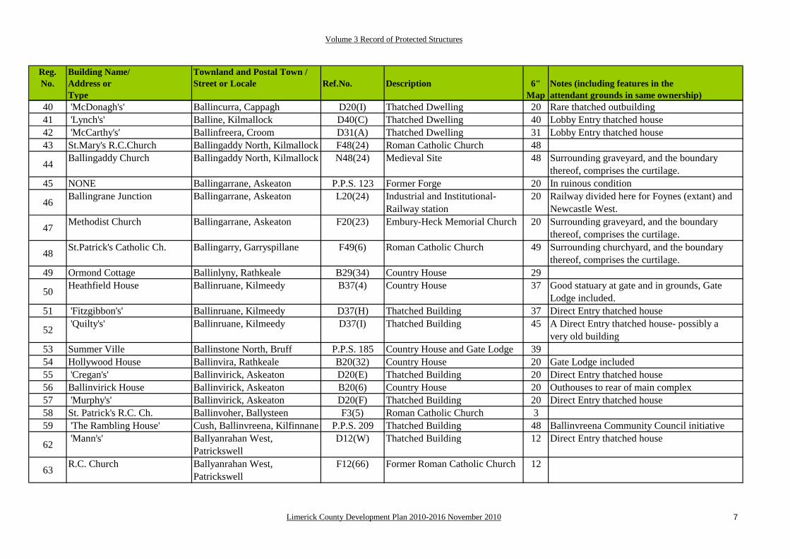
40 'McDonagh's' Ballincurra, Cappagh D20(I) Thatched Dwelling 20 Rare thatched outbuilding41 'Lynch's' Balline, Kilmallock D40(C) Thatched Dwelling 40 Lobby Entry thatched house42 'McCarthy's' Ballinfreera, Croom D31(A) Thatched Dwelling 31 Lobby Entry thatched house43 St.Mary's R.C.Church Ballingaddy North, Kilmallock F48(24) Roman Catholic Church 48
44 Ballingaddy Church Ballingaddy North, Kilmallock N48(24) Medieval Site 48 Surrounding graveyard, and the boundary thereof, comprises the curtilage.
45 NONE Ballingarrane, Askeaton P.P.S. 123 Former Forge 20 In ruinous condition
46 Ballingrane Junction Ballingarrane, Askeaton L20(24) Industrial and Institutional- Railway station
20 Railway divided here for Foynes (extant) and Newcastle West.
47 Methodist Church Ballingarrane, Askeaton F20(23) Embury-Heck Memorial Church 20 Surrounding graveyard, and the boundary thereof, comprises the curtilage.
48 St.Patrick's Catholic Ch. Ballingarry, Garryspillane F49(6) Roman Catholic Church 49 Surrounding churchyard, and the boundary thereof, comprises the curtilage.
49 Ormond Cottage Ballinlyny, Rathkeale B29(34) Country House 29
50 Heathfield House Ballinruane, Kilmeedy B37(4) Country House 37 Good statuary at gate and in grounds, Gate Lodge included.
51 'Fitzgibbon's' Ballinruane, Kilmeedy D37(H) Thatched Building 37 Direct Entry thatched house
52 'Quilty's' Ballinruane, Kilmeedy D37(I) Thatched Building 45 A Direct Entry thatched house- possibly avery old building
53 Summer Ville Ballinstone North, Bruff P.P.S. 185 Country House and Gate Lodge 3954 Hollywood House Ballinvira, Rathkeale B20(32) Country House 20 Gate Lodge included55 'Cregan's' Ballinvirick, Askeaton D20(E) Thatched Building 20 Direct Entry thatched house56 Ballinvirick House Ballinvirick, Askeaton B20(6) Country House 20 Outhouses to rear of main complex57 'Murphy's' Ballinvirick, Askeaton D20(F) Thatched Building 20 Direct Entry thatched house58 St. Patrick's R.C. Ch. Ballinvoher, Ballysteen F3(5) Roman Catholic Church 359 'The Rambling House' Cush, Ballinvreena, Kilfinnane P.P.S. 209 Thatched Building 48 Ballinvreena Community Council initiative
62 'Mann's' Ballyanrahan West, Patrickswell
D12(W) Thatched Building 12 Direct Entry thatched house
63 R.C. Church Ballyanrahan West, Patrickswell
F12(66) Former Roman Catholic Church 12

Volume 3 Record of Protected Structures
Limerick County Development Plan 2010-2016 November 2010 8
Reg.No.
Building Name/Address orType
Townland and Postal Town /Street or Locale Ref.No. Description 6"
Map Notes (including features in the attendant grounds in same ownership)
64 Church Ballybricken North, Grange F23(24) Roman Catholic Church 23 Surrounding churchyard, and the boundary thereof, comprises the curtilage.
65 Springfort Ballybronoge North, Patrickswell
B12(54) Country House 12
66 Ballybrood House Ballybrood, Caherline B23(13) Country House 23 Stables intact
68 Church Ballycahane Upper, Crecora G22(45) Church of Ireland 22 Surrounding graveyard, and the boundary thereof, comprises the curtilage.
69 Duneeven House Ballycannon, Croagh B20(1) Country House 20
70 Ashgrove House Ballycasey, Kildimo B12(35)/D12(F)
Country House- Thatched 12 Rare two-storey thatched house
71 Ballyclogh House Ballyclogh, Annacotty B6(10) Country House 672 Ballyclogh House Ballyclogh, Rosbrien, B13(26) Country House 1373 NONE Ballyclogh, Askeaton P.P.S. 118 'Concrete Pill Box (1)' 10 Military Infrastructure74 NONE Ballyclogh, Askeaton P.P.S. 119 'Concrete Pill Box (2)' 19 Military Infrastructure75 NONE Ballyclogh, Askeaton P.P.S. 120 'Concrete Pill Box (3)' 19 Military Infrastructure
76 Ballyclogh House Ballyclogh, Askeaton P.P.S. 117 Country House and castle 19 Archaeological Heritage Identifier (R.M.P. No. Li-019-236) also present
77 Castle (In ruins) Ballyculhane, Kildimo A12(63) Medieval Structure- Keepless Castle
12 Large rectangular enclosure, 17thCentury House & adjacent Bastion
78 'O'Brien's' Ballyculhane, Kildimo D12(L) Thatched Building 12 Lobby Entry thatched house
79 NONE Ballycullane Lower, Glin P.P.S. 95 Vernacular farmhouse, associated farmyard and
17In the attendant lands of the Glin Estate
81 Ballydonnell House Ballydonnell, Feohanagh D45(H) Thatched Building 45 Lobby Entry thatched house82 'Mr. Bunce's Kiln' Ballydonohoe, Glin L17(19) Lime Kiln 17
83 Ballydonohoe House Ballydonohoe, Glin P.P.S. 94 Country House (Georgian era) 17 Formerly the Church of Ireland Rectory for Tarbert
84 'Curtin's' Ballydoorty, Knockaderry D37(J) Thatched Building 37 Lobby Entry thatched house85 Glenogra Bridge Ballyea-Glenogra, Fedamore H22/31(22) Bridge 2287 Ballyegny House Ballyegny More, Ardagh B28(22) Country House 2888 Mr. Barrett's House Ballyengland Lower, Askeaton P.P.S. 67 Thatched House 11

Volume 3 Record of Protected Structures
Limerick County Development Plan 2010-2016 November 2010 9
Reg.No.
Building Name/Address orType
Townland and Postal Town /Street or Locale Ref.No. Description 6"
Map Notes (including features in the attendant grounds in same ownership)
89 'O'Shaughnessy's Ballyengland Lower, Askeaton D11(H) Thatched Building- Stables 11 Rare example of thatched outbuildings
90 Stewick House Ballyengland Upper, Askeaton B11(29) Country House 11 May have been an institutional building originally
91Castle Hewson Ballyengland Upper, Askeaton B11(30) Country House 11 Tower House with attached 18th C.
buildings, Demesne features include terraced gardens & Hewson family burial ground
92 'O'Shea's' Ballyfookeen, Rockhill, Bruree D38(C) Thatched Building 38 Direct Entry thatched house
93 'Murray's' Ballyfookeen, Rockhill, Bruree D38(D) Thatched Building 38 Direct Entry thatched house
94 St.Munchin's R.C.Church
Ballyfookeen, Rockhill, Bruree
F38(2) Roman Catholic Church 38 Surrounding churchyard, and the boundary thereof, comprises the curtilage.
95 'Higgins's' Ballygeale, Patrickswell D21(O) Thatched Building 21 An original thatched house with a thatchedtwo-storey extension
96 'Carmody's' Ballygeale, Patrickswell D21(N) Thatched Building 21 Direct Entry thatched house97 'The Kitchener Kiln' Ballygoghlan, Glin L17(25) Lime Kiln 17 Industrial structure- contains two hearths
98 Ballygrennan Castle Ballygrennan, Bruff A/N40(9) 17th Century House 40 Double Bawn, includes medievalTower House and 17th century house
99 St.Mary's R.C.Church Ballygrennan, Bulgaden F40(1) Roman Catholic Church 40100 'Mr. Fitzgerald's Kiln' Ballygiltenan Upper, Glin L18(25) Lime Kiln 18101 'Mrs.Fennell's Kiln' Ballygiltenan, Glin L26(2) Lime Kiln 26102 'Mr.O'Connor's Kiln' Ballygiltenan North, Glin L17(22) Lime Kiln 17103 'Mr.O'Shaughnessy's' Ballygiltenan Lower, Glin L18(20) Lime Kiln 18104 Fort Shannon Ballyhoolahan, Glin B17(16) Country House 17105 'Mr. Moore's Kiln' Ballyhoolahan, Glin L17(20) Lime Kiln 17106 Ballykealy House Ballykealy, Ardagh B28(21) Country House 28107 Ballyknockane House Ballyknockane, Ballingarry B30(48) Country House 30 Eyecatcher on main road
108 Cross Cottages [A] Ballylin, Ardagh B28(12) Country House- Estate Cottages 28 First of two Gothic revival style estate cottages
Volume 3 Record of Protected Structures
Limerick County Development Plan 2010-2016 November 2010 10
Reg.No.
Building Name/Address orType
Townland and Postal Town /Street or Locale Ref.No. Description 6"
Map Notes (including features in the attendant grounds in same ownership)
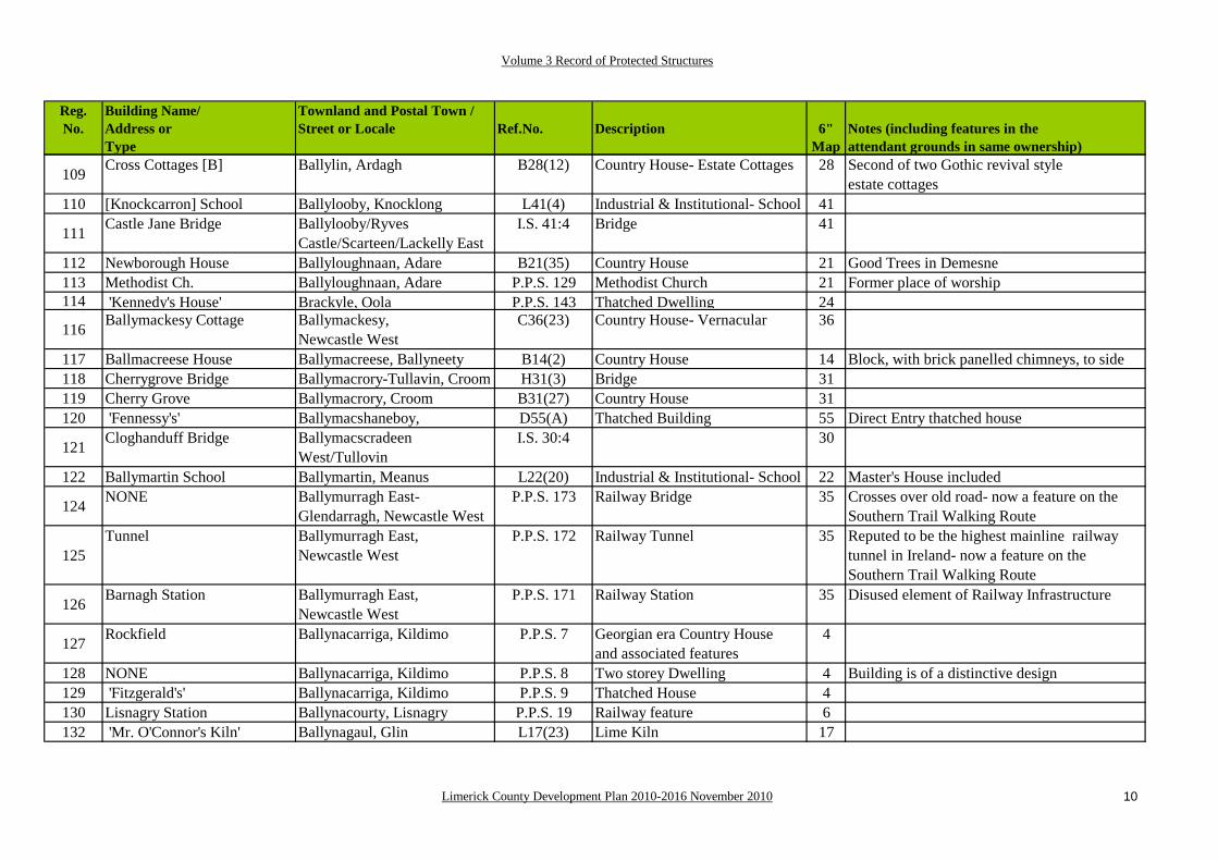
109 Cross Cottages [B] Ballylin, Ardagh B28(12) Country House- Estate Cottages 28 Second of two Gothic revival style estate cottages
110 [Knockcarron] School Ballylooby, Knocklong L41(4) Industrial & Institutional- School 41
111 Castle Jane Bridge Ballylooby/Ryves Castle/Scarteen/Lackelly East
I.S. 41:4 Bridge 41
112 Newborough House Ballyloughnaan, Adare B21(35) Country House 21 Good Trees in Demesne113 Methodist Ch. Ballyloughnaan, Adare P.P.S. 129 Methodist Church 21 Former place of worship114 'Kennedy's House' Brackyle, Oola P.P.S. 143 Thatched Dwelling 24
116 Ballymackesy Cottage Ballymackesy, Newcastle West
C36(23) Country House- Vernacular 36
117 Ballmacreese House Ballymacreese, Ballyneety B14(2) Country House 14 Block, with brick panelled chimneys, to side118 Cherrygrove Bridge Ballymacrory-Tullavin, Croom H31(3) Bridge 31119 Cherry Grove Ballymacrory, Croom B31(27) Country House 31120 'Fennessy's' Ballymacshaneboy, D55(A) Thatched Building 55 Direct Entry thatched house
121 Cloghanduff Bridge Ballymacscradeen West/Tullovin
I.S. 30:4 30
122 Ballymartin School Ballymartin, Meanus L22(20) Industrial & Institutional- School 22 Master's House included
124 NONE Ballymurragh East-Glendarragh, Newcastle West
P.P.S. 173 Railway Bridge 35 Crosses over old road- now a feature on the Southern Trail Walking Route
125Tunnel Ballymurragh East,
Newcastle WestP.P.S. 172 Railway Tunnel 35 Reputed to be the highest mainline railway
tunnel in Ireland- now a feature on the Southern Trail Walking Route
126 Barnagh Station Ballymurragh East, Newcastle West
P.P.S. 171 Railway Station 35 Disused element of Railway Infrastructure
127 Rockfield Ballynacarriga, Kildimo P.P.S. 7 Georgian era Country Houseand associated features
4
128 NONE Ballynacarriga, Kildimo P.P.S. 8 Two storey Dwelling 4 Building is of a distinctive design129 'Fitzgerald's' Ballynacarriga, Kildimo P.P.S. 9 Thatched House 4 130 Lisnagry Station Ballynacourty, Lisnagry P.P.S. 19 Railway feature 6 132 'Mr. O'Connor's Kiln' Ballynagaul, Glin L17(23) Lime Kiln 17

Volume 3 Record of Protected Structures
Limerick County Development Plan 2010-2016 November 2010 11
Reg.No.
Building Name/Address orType
Townland and Postal Town /Street or Locale Ref.No. Description 6"
Map Notes (including features in the attendant grounds in same ownership)
133 Ballynagarde House Ballynagarde, Ballyneety B22(43) Country House 22 Pedimented Gate Lodge to N.E.134 Williamstown Castle Ballynagarde, Ballyneety B/N22(37) Country House 22
135 'Costello's' Ballynagoul, Kilmallock P.P.S. 206 Vernacular farmhouse, associated farmyard and
47
136 NONE Ballynahaha, Ballingarry P.P.S. 157 Estate feature- eyecatcher 30 Archway with pediment with rusticated keystones and arched recesses
137 Ballynahinch House Ballynahinch, Kilfinnane P.P.S. 210 Country House 48138 Ballynahinch Bridge Ballynahinch, Kilfinnane H48(38) Bridge 48139 Castle (in Ruins) Ballynahinch, Kilfinnane A48(36) 17th Century House 48 Later chimney stacks140 Ballynakill House Ballynakill, Kilfinny, Adare B30(42) Country House 30141 Ballynamona House Ballynamona, Hospital B32(80) Country House 32142 Ballynamona Bridge Ballynamona, Hospital H32(27) Bridge 32
143 Ballynamona Church, (in Ruins)
Ballynamona, Hospital N32(26) Medieval Site 32 Surrounding graveyard, and the boundary thereof, comprises the curtilage.
144 'Treacy's' Ballynamona, Bulgaden D40(G) Thatched Dwelling 40 Lobby Entry thatched house
145 'O'Donovan's' Ballynamuddagh, Glin D17(B) Thatched Dwelling 17 Lobby Entry thatched house which is L-shapedin Plan Form
146 Lynch's Thatched House Ballynamuddagh, Glin P.P.S. 96 Thatched Dwelling 17 Identified previously as D17(A)
147Ballynamuddagh House Ballynamuddagh, Athlacca P.P.S. 180 Vernacular Country House,
associated farmyard and outbuildings
39
149 Odell Ville Ballynarooga Beg (West), Ballingarry
B37(7) Country House 37 Gothick Lodge on road
150 St. Oswald's Ballynarooga Beg (West), Ballingarry
B37(23) Country House 37
151 Ballyneale House Ballyneale, Ballingarry B38(20) Country House 38 Blank attached wings152 St.Brigid's Catholic Ch. Ballyneety North, Oola F33(9) Roman Catholic Church 33 Known as Templebraden Church153 'Flynn's' Ballyniska, Feohanagh D44(C) Thatched Building 44 Lobby Entry thatched house
Volume 3 Record of Protected Structures
Limerick County Development Plan 2010-2016 November 2010 12
Reg.No.
Building Name/Address orType
Townland and Postal Town /Street or Locale Ref.No. Description 6"
Map Notes (including features in the attendant grounds in same ownership)
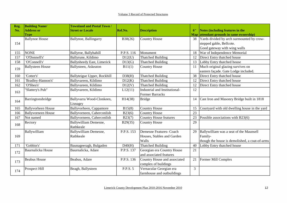
154Ballynoe House Ballynoe, Ballingarry B38(26) Country House 38 Yards divided by arch surmounted by crow-
stepped gable, Bellcote.Good gateway with wing walls
155 NONE Ballyroe, Ballyhahill P.P.S. 116 Monument 18 War of Independence Memorial157 'O'Donnell's' Ballyrune, Kildimo D12(U) Thatched Building 12 Direct Entry thatched house158 'O'Connell's' Ballysheedy East, Limerick D13(G) Thatched Building 13 Lobby Entry thatched house
159 Ballysteen House Ballysteen, Askeaton B11(1) Country House 11 Much original glazing survives on eastern façade. Gate Lodge included.
160 'Cotter's' Ballyteigue Upper, Rockhill D38(H) Thatched Building 38 Direct Entry thatched house161 'Bradley-Hannon's' Ballyvareen, Kildimo D12(K) Thatched Building 12 Direct Entry thatched house162 'O'Shea's' Ballyvareen, Kildimo D12(V) Thatched Building 12 Direct Entry thatched house
163 "Slattery's Pub" Ballyvareen, Kildimo L12(11) Industrial and Institutional-Former Barracks
12
164 Barringtonsbridge Ballyvarra Wood-Clonkeen, Lisnagry
H14(38) Bridge 14 Cast Iron and Masonry Bridge built in 1818
165 Ballyvorheen House Ballyvorheen, Cappamore B15(8) Country House 15 Courtyard with old dwelling house in the yard166 Ballyvorneen House Ballyvorneen, Caherconlish B23(6) Country House 23167 Not named Ballyvorneen, Caherconlish B23(7) Country House features 23 Possible associations with B23(6)
168 Rectory Ballywilliam Demesne,Rathkeale
B29(35) Country House 29
169Ballywilliam Ballywilliam Demesne,
RathkealeP.P.S. 153 Demesne Features- Coach
Houses, Stables and Garden Walls
29 Ballywilliam was a seat of the Maunsell Family- though the house is demolished, a coat-of-arms
171 'Gobbin's' Baunageeragh, Bulgaden D40(H) Thatched Building 40 Lobby Entry thatched house
172 Baurnalicka House Baurnalicka, Adare P.P.S. 137 Georgian era Country Houseand associated features
21
173 Beabus House Beabus, Adare P.P.S. 136 Country House and associated complex of buildings
21 Former Mill Complex
174 Prospect Hill Beagh, Ballysteen P.P.S. 5 Vernacular Georgian era farmhouse and outbuildings
3

Volume 3 Record of Protected Structures
Limerick County Development Plan 2010-2016 November 2010 13
Reg.No.
Building Name/Address orType
Townland and Postal Town /Street or Locale Ref.No. Description 6"
Map Notes (including features in the attendant grounds in same ownership)
176 Beagh Castle (in Ruins)
Beagh, Ballysteen N3(1) Medieval Site 3 Extensive Bawn and later structures, including battery and housing.
177 Beagh Church (inRuins)
Beagh, Ballysteen N3(7) Medieval Site 3 Surrounding graveyard, and the boundary thereof, comprises the curtilage.
178 Beechmount House Beechmount Demesne, Rathkeale.
B29(5) Country House 29 Low wings, Cut-stone Gate Lodge,Fine cut-stone gate pillars
179 St.Patrick's CatholicChurch
Biddyford, Ahane, Lisnagry F6(28) Roman Catholic Church 6
180 Bilboa Court Bilboa, Cappamore A15(19) 17th Century House 15 Formal garden layout with redoubtsand remains of bridge
181 Bilboa Bridge Bilboa-Cooga Upper-Cooga Lower, Cappamore
H15(4) Bridge 15
182 Blackboy Bridge Bilboa-Darkisland, Cappamore H15(3) Bridge 15
183 Stonehall Catholic Ch. Blossomhill, Pallaskenry F11(18) Roman Catholic Church 11184 'Coughlan's' Bohard, Dromcollogher D45(C) Thatched Building 45 Lobby Entry thatched house185 'O'Meara's' Sandylane,Boher D14(K) Thatched Building 14 Lobby Entry thatched house186 Bolane House Bolane, Kildimo B12(5) Country House 12187 'Herbert's' Bresheen South, Kilmallock D47(C) Thatched Building 47 Lobby Entry thatched house188 Brittas Castle (in Ruins) Brittas, Boher N14(57) Medieval Site 14190 Creamery Bulgaden, Kilmallock L40(3) Industrial and Institutional 40191 'Gubbin's' Bulgaden, Kilmallock D40(F) Thatched Building 40 Direct Entry thatched house
192 Bulgaden Castle (in Ruins)
Bulgaden Eady, Kilmallock N40(4) Medieval Site 40
193 Caheragh House Caheragh, Glin B18(1) Country House 18
194 Caherass House Caherass, Croom B21(29) Country House Features- Stablesand Coach House Block
21 U-shaped Stable Block
195 Caherconlish House Caherconlish Townland, Casherconlish
B14(59) Country House Feature- Fish Pond
14 Fish Pond
196 'McCarthy's' Cahercorney, Herberstown C32(81) Country House- Vernacular 32
Volume 3 Record of Protected Structures
Limerick County Development Plan 2010-2016 November 2010 14
Reg.No.
Building Name/Address orType
Townland and Postal Town /Street or Locale Ref.No. Description 6"
Map Notes (including features in the attendant grounds in same ownership)
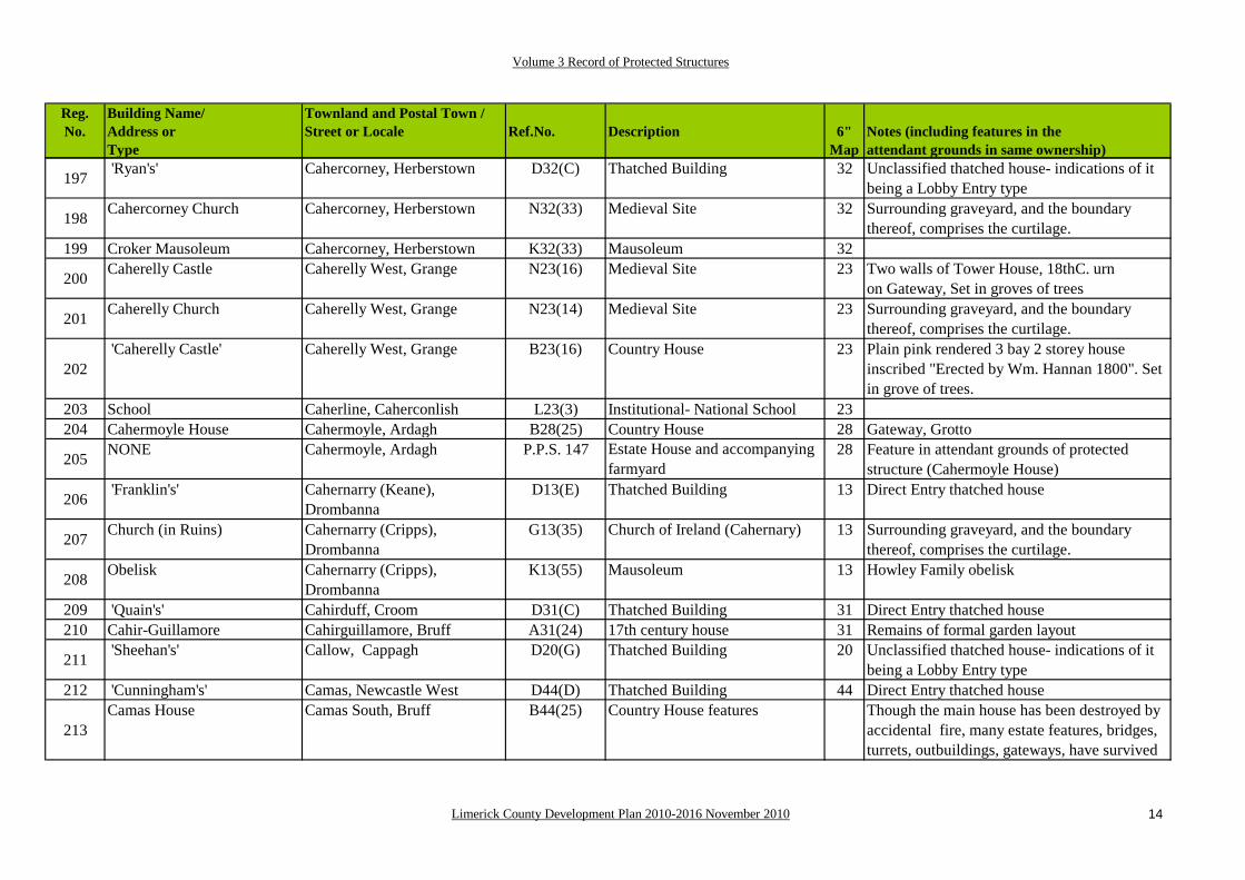
197 'Ryan's' Cahercorney, Herberstown D32(C) Thatched Building 32 Unclassified thatched house- indications of itbeing a Lobby Entry type
198 Cahercorney Church Cahercorney, Herberstown N32(33) Medieval Site 32 Surrounding graveyard, and the boundary thereof, comprises the curtilage.
199 Croker Mausoleum Cahercorney, Herberstown K32(33) Mausoleum 32
200 Caherelly Castle Caherelly West, Grange N23(16) Medieval Site 23 Two walls of Tower House, 18thC. urnon Gateway, Set in groves of trees
201 Caherelly Church Caherelly West, Grange N23(14) Medieval Site 23 Surrounding graveyard, and the boundary thereof, comprises the curtilage.
202 'Caherelly Castle' Caherelly West, Grange B23(16) Country House 23 Plain pink rendered 3 bay 2 storey house
inscribed "Erected by Wm. Hannan 1800". Set in grove of trees.
203 School Caherline, Caherconlish L23(3) Institutional- National School 23204 Cahermoyle House Cahermoyle, Ardagh B28(25) Country House 28 Gateway, Grotto
205 NONE Cahermoyle, Ardagh P.P.S. 147 Estate House and accompanying farmyard
28 Feature in attendant grounds of protected structure (Cahermoyle House)
206 'Franklin's' Cahernarry (Keane), Drombanna
D13(E) Thatched Building 13 Direct Entry thatched house
207 Church (in Ruins) Cahernarry (Cripps), Drombanna
G13(35) Church of Ireland (Cahernary) 13 Surrounding graveyard, and the boundary thereof, comprises the curtilage.
208 Obelisk Cahernarry (Cripps), Drombanna
K13(55) Mausoleum 13 Howley Family obelisk
209 'Quain's' Cahirduff, Croom D31(C) Thatched Building 31 Direct Entry thatched house 210 Cahir-Guillamore Cahirguillamore, Bruff A31(24) 17th century house 31 Remains of formal garden layout
211 'Sheehan's' Callow, Cappagh D20(G) Thatched Building 20 Unclassified thatched house- indications of itbeing a Lobby Entry type
212 'Cunningham's' Camas, Newcastle West D44(D) Thatched Building 44 Direct Entry thatched house
213Camas House Camas South, Bruff B44(25) Country House features Though the main house has been destroyed by
accidental fire, many estate features, bridges, turrets, outbuildings, gateways, have survived

Volume 3 Record of Protected Structures
Limerick County Development Plan 2010-2016 November 2010 15
Reg.No.
Building Name/Address orType
Townland and Postal Town /Street or Locale Ref.No. Description 6"
Map Notes (including features in the attendant grounds in same ownership)
214 Cantogher Cottage Cantogher, Ashford B44(6) Country House 44 Stables courtyard to rear215 Cappagh House Cappagh, Askeaton B20(42) Country House 20216 Cappagh Castle Cappagh, Askeaton N20(40) Medieval Site 20
217 Cappagh Church Cappagh, Askeaton N20(41) Medieval Site 20 Surrounding graveyard, and the boundary thereof, comprises the curtilage.
218 Glenbrook House Cappanihane, Bruree B38(22) Country House 38
219 Lodge Cappercullen, Murroe B7(8)A Country House Feature 7 Gate Lodge- now serves as the main entrance to Glenstal Abbey (See No. 358 below).
221 Castletown Church Carrig Beg, Doon N25(7) Medieval Site 25 Surrounding graveyard, and the boundary thereof, comprises the curtilage.
222 Carrigoreely Castle Carrigarreely, Caherconlish A/N14(56) 17th Century House 14 Fragment of Hall and wing
223 Dysert Church Carrigeen, Croom N30(30)A Medieval Site 30 Surrounding graveyard, and the boundary thereof, comprises the curtilage.
224 Dysert Round Tower Carrigeen, Croom N30(30)B Medieval Site 30225 St.Mary's R.C.Church Carrigkerry, Ardagh F27(1) Roman Catholic Church 27226 Carrigogunnell Castle Carrigogunnel, Clarina N4(6) Medieval Site 4227 'Fitzgibbon Memorial' Carrowkeel, Lisnagry P.P.S. 17 Wayside Memorial 6228 Cartown House Cartown, Kildimo B4(1) Country House 4 Extensive Stables & Gate Lodge
229 'Leonard's' Castle-erkin North, Pallasgreen
D14(M) Thatched Building 14 Rare thatched Outhouse
230 'Mulcahy's' Castle-erkin South, Pallasgreen
D14(L) Thatched Building 14 Direct Entry thatched house
231 Castle Garde Castlegarde, Cappamore B15(2) Country House 15 Tower House re-modelled in 19thcentury, Good Demesne
233 Rathkeale Cottage Castlematrix, Rathkeale B29(11) Country House 29 Semi-circular cobbled area, with patterns and designs, to front
234 Castle Matrix Castlematrix, Rathkeale N29(4) Medieval Site 29 Bawn largely survives, separate stables and outhouses included in the curtilage.
235 Clonodfoy/Castle Oliver Castleoliver-Raheeroe B56(18) Country House 56 2 Gate Lodges included as separate entries236 Lodge Castleoliver, Ardpatrick B56(18)A Country House Feature 56 The Ardpatrick Gate Lodge

Volume 3 Record of Protected Structures
Limerick County Development Plan 2010-2016 November 2010 16
Reg.No.
Building Name/Address orType
Townland and Postal Town /Street or Locale Ref.No. Description 6"
Map Notes (including features in the attendant grounds in same ownership)
237 Lodge (Not named) Castleoliver, Ardpatrick B56(18)B Country House Feature 56 The Glenosheen Gate Lodge
238 Oliver's Folly Castleoliver, Ardpatrick P.P.S. 224 Estate feature- Eyecatcher 56 Feature in the attendant grounds of a protectedstructure (Castle Oliver)
239 NONE Castleoliver, Ardpatrick P.P.S. 225 Estate feature- Tunnel 56 Feature in the attendant grounds of a protectedstructure (Castle Oliver)
240 Castle Oliver Farm Castleoliver, Ardpatrick P.P.S. 226 Estate Feature- Home Farm 56 Feature in the attendant grounds of a protectedstructure (Castle Oliver)
241Coill-beithne Castle (in Ruins)
Castlequarter, Kilbehenny N58(1) Medieval Site 58 Garrisoned by Cromwell in 1650 as recorded by him in a letter to the Speaker of the House of Commons.
242 "The Thatch Pub" Castleroberts, Adare D21(M) Thatched Building 21 Thatched Public House
243 NONE Castleroberts, Adare P.P.S. 132 Semi-detached 2 storey dwelling 21 Feature in attendant grounds of protected structure (Fanningstown Castle)
244 NONE Castleroberts, Adare P.P.S. 133 Semi-detached 2 storey dwelling 21 Feature in attendant grounds of protected structure (Fanningstown Castle)
245 Lodge Castleroberts, Adare P.P.S. 134 Back entrance to Adare Manor 21 Feature in attendant grounds ofprotected structure (Adare Manor)
246 NONE Castleroberts, Adare P.P.S. 135 Gateway 21 Feature in attendant grounds ofprotected structure (Adare Manor)
247 Castleroberts Castleroberts, Adare A21(25) 17th Century House 21 Projecting Turret at corner
248 Boyce's Thatched House Castletown, Castletown Conyers
P.P.S. 202 Thatched Building 46
249Castletown Conyers Castletown, Castletown
ConyersB38(30) Country House 38 Large gabled return with dormers,
Remains of formal garden (includesornamental pond with statue)
250 Church (in ruins) Castletown, Castletown Conyers
N38(27) Medieval Site 38 Surrounding graveyard, and the boundary thereof, comprises the curtilage.
251 Castle (in ruins) Castletown, Castletown Conyers
N38(31) Medieval Site 38 Castletown Castle
252 'O'Connor's' Clash North, Athea C35(1) Country House- Vernacular 35

Volume 3 Record of Protected Structures
Limerick County Development Plan 2010-2016 November 2010 17
Reg.No.
Building Name/Address orType
Townland and Postal Town /Street or Locale Ref.No. Description 6"
Map Notes (including features in the attendant grounds in same ownership)
254 Pallas Green (old) Cloghaderreen, Old Pallas N24 (48) Medieval Site 24 Motte255 'Ferrybridge Tavern' Cloghatacka, Clarina D12(A) Thatched Building 12 Thatched Public House256 'Culhane's' Cloghatacka, Clarina D12(D) Thatched Building 12 Direct Entry thatched house257 Ferry Bridge Cloghatacka-Court, Clarina H12(16) Bridge 12258 Clonagh House Clonagh, Ardagh B28(32) Country House 28259 R.C. Church Cloncagh, Ballingarry F37(22) Roman Catholic Church 37260 Carnegie Library Cloncagh, Ballingarry P.P.S. 176 Civic Structure 37 Cultural and Social Significance261 'Baggott's' Cloncagh, Ballingarry D37(A) Thatched Building 37 Direct Entry thatched house
262 Cloncagh Church (in ruins) Cloncagh, Ballingarry N37(13) Medieval Site within an Early Christian Enclosure
37 Surrounding graveyard, and the boundary thereof, comprises the curtilage
263 Barringtonsbridge House
Clonkeen (Barrington), Lisnagry
B14(36) Country House 14
264 Clonkeen Church Clonkeen (Barrington), Lisnagry
N14(35) Medieval Site 14 Surrounding graveyard, and the boundary thereof, comprises the curtilage
265 Clonshire Lodge Clonshire Beg, Adare B21(14) Country House 21 Two ruined Gothick cottages266 Clonshire Castle Clonshire More, Adare A/N21(16) 17th Century House 20 Adjacent derelict thatched house
267 Clonshire Church Clonshire More, Adare N21(17) Medieval Site 21 Surrounding graveyard, and the boundary thereof, comprises the curtilage
268 'Mr. Foley's Kiln' Clonoughter, Glin L18(17) Lime Kiln 18270 'Hayes's' Clooncaura, Kildimo P.P.S. 71 Thatched Building 12 Lobby Entry thatched house271 'Lane's' Clooncrippa, Feenagh D45(G) Thatched Building 45 Direct Entry thatched house
273 Broken Bridge Cloonpasteen-Tulligmacthomas, Kilmeedy
H45(12) Bridge 45
274 Not named Common, Ballingarry D38(F) Thatched Building 38 Knockfierna Heritage Group276 Coonagh Castle Coolbaun, Pallasgreen N25(3) Medieval Site 25277 'Stokes's' Coolbeg, Kildimo D12(M) Thatched Building 12 Lobby Entry thatched house278 'Guinane's' Coolbeg, Kildimo D12(N) Thatched Building 12 Direct Entry thatched house279 School Coolbeg, Kildimo L12(46) Industrial and Institutional 12
280 'Luddy's' Coolboy, Kilbehenny C58(3) Country House- Vernacular 58 House type is associated with the Mitchelstown Castle Estate.
Volume 3 Record of Protected Structures
Limerick County Development Plan 2010-2016 November 2010 18
Reg.No.
Building Name/Address orType
Townland and Postal Town /Street or Locale Ref.No. Description 6"
Map Notes (including features in the attendant grounds in same ownership)
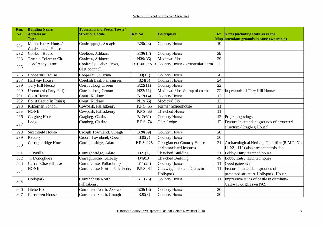
281 Mount Henry House/Coolcappagh House
Coolcappagh, Ardagh B28(28) Country House 19
282 Cooleen House Cooleen, Athlacca B39(17) Country House 39283 Temple Coleman Ch. Cooleen, Athlacca N39(36) Medieval Site 39
285 'Coolready Farm' Coolreidy, Daly's Cross,
CastleconnellB1(3)/P.P.S. 3 Country House- Vernacular Farm 1
286 Cooperhill House Cooperhill, Clarina B4(18) Country House 4287 Halfway House Corelish East, Pallasgreen B24(6) Country House 24289 Tory Hill House Corrabulbeg, Croom B22(11) Country House 22290 Unmarked (Tory Hill) Corrabulbeg, Croom N22(11) Medieval Site- Stump of castle 22 In grounds of Tory Hill House291 Court House Court, Kildimo B12(14) Country House 12292 Court Castle(in Ruins) Court, Kildimo N12(65) Medieval Site 12293 Kilcornan School Cowpark, Pallaskenry P.P.S. 65 Former Schoolhouse 11295 NONE Cowpark, Pallaskenry P.P.S. 66 Thatched House 11296 Cragbeg House Cragbeg, Clarina B12(62) Country House 12 Projecting wings
297 Lodge Cragbeg, Clarina P.P.S. 74 Gate Lodge 12 Feature in attendant grounds of protected structure (Cragbeg House)
298 Smithfield House Croagh Townland, Croagh B20(39) Country House 20299 Rectory Croom Townland, Croom B30(2) Country House 30
300 Curraghbridge House Curraghbridge, Adare P.P.S. 128 Georgian era Country Houseand associated features
21 Archaeological Heritage Identifier (R.M.P. No. Li-021-112) also present at this site
301 'O'Neill's' Curraghbridge, Adare D21(L) Thatched Building 21 Lobby Entry thatched house302 'O'Donoghue's' Curraghroche, Galbally D49(B) Thatched Building 49 Lobby Entry thatched house303 Currah Chase House Currahchase, Pallaskenry B11(24) Country House 11 Good gateways
304 NONE Currahchase North, Pallaskenry P.P.S. 64 Gateway, Piers and Gates to Hollypark
11 Feature in attendant grounds ofprotected structure Hollypark [House]
305 Hollypark Currahchase North, Pallaskenry
B11(25) Country House 11 Impressive ruins of castle in curtilage- Gateway & gates on N69
306 Glebe Ho. Curraheen North, Askeaton B20(13) Country House 20307 Curraheen House Curraheen South, Croagh B20(8) Country House 20

Volume 3 Record of Protected Structures
Limerick County Development Plan 2010-2016 November 2010 19
Reg.No.
Building Name/Address orType
Townland and Postal Town /Street or Locale Ref.No. Description 6"
Map Notes (including features in the attendant grounds in same ownership)
308 Gowlagh Bridge Curraghafoil, Doon I.S. 8:1 Bridge 8
309 Commaun Bridge Curraghafoil-Curraghakimikeen, Doon
I.S. 8:2 Bridge 8
310 Fraher's Thatched House Curraghkilbran, Galbally P.P.S. 211 Thatched Building 49 Lobby Entry thatched house
311 Darragh House Darragh More, Darragh, Kilfinnane
P.P.S. 230 Country House and associated Coach Houses, Stables
57
312 Darragh Church Darragh More, Kilfinnane N57(4) Medieval Site 57 Graveyard313 'Shanahan's' Deelish, Ardagh D28(A) Thatched Building 28 Lobby Entry thatched house314 Derk Derk, Pallasgreen B24(41) Country House 24 Folly on hill, Good Demesne315 'O'Brien's' Derrybeg, Rosbrien, Limerick D13(H) Thatched Building 13 Direct Entry thatched house- L-shaped Plan316 Clancy Homestead Derryknockane, Rosbrien, P.P.S. 76 Vernacular House 13 Birthplace of Mayor Clancy, murdered during
317 R.C. Church Dohora, Banogue F30(6) Roman Catholic Church 30318 School Dohora, Banogue L30(7) Industrial and Institutional- Schoo 30320 Dollas House Dollas Upper, Croom B30(13) Country House- Vernacular 30
321 'O'Connor's' Doonbeirne, Ballingarry D37(E) Thatched Building 37 Unclassified thatched house- indications of itbeing a Direct Entry type
322 Dooneen House Dooneen, Crecora B22(7) Country House 22
323 'Stanley's' Doonvullen Lower, Caherconlish
D23(B) Thatched Building 23 Stables block forms, in part, boundary of front gardens
324 Church (in Ruins) Drehidtarsna, Adare G21(23) Church of Ireland 21 Surrounding graveyard, and the boundary thereof, comprises the curtilage.
325 'Parker's' Drewscourt East, Ballyagran D46(D) Thatched Building 46 Lobby Entry thatched house with a thatched open porch
326 'O'Malley's' Dromalta, Cappamore D15(F) Thatched Building 15 Lobby Entry thatched house
327 Dromard House akaMount Browne
Dromard Demesne, Rathkeale B29(10) Country House 29
328 "Dromkeen House" Drombane B24(46) Country House 24329 Dromkeen Station Drombane-Mountsion P.P.S. 141 Railway Station 24 Railway Infrastructure, currently mothballed
330 Dromkeen Bridge Drombane-Mountsion-Pallasbeg, Dromkeen
H24(7) Bridge 24

Volume 3 Record of Protected Structures
Limerick County Development Plan 2010-2016 November 2010 20
Reg.No.
Building Name/Address orType
Townland and Postal Town /Street or Locale Ref.No. Description 6"
Map Notes (including features in the attendant grounds in same ownership)
331 Donaghmore Church (in Ruins)
Drombanny, Limerick N13(40) Medieval Site- Church 13 Surrounding graveyard, and the boundary thereof, comprises the curtilage.
334 Knockea R.C. Church Drombanny, Limerick F13(34) Roman Catholic Church 13
335 Abington House Dromeliagh, Murroe B14(28) Country House- two storey with fine pedimented gateway
14 Entrance arch, U-shaped stableyard
336 'Tierney's' Dromin North, Athlacca D39(B) Thatched Building 39 Thatched Public House
337 Fair Green Dromin North, Athlacca P.P.S. 179 Fair Green 39 Bargain Stone is significant historical feature of this site
338 Holy Trinity R.C. Ch Dromin South, Athlacca F39(27) Roman Catholic Church 39
339 Dromin Church (in R.) Dromin South, Athlacca N39(29) Medieval Site 39 Surrounding graveyard, and the boundary thereof, comprises the curtilage.
340 'Hourigan's' Drominboy Upper, Lisnagry D6(C) Thatched Building 6 Direct Entry thatched house
341 Dromkeen House Dromkeen North, Dromkeen B24(9)A Country House 24 Gate Lodge opposite gate, Medieval Gatehouse in grounds (see below)
342 Lodge Dromkeen North, Dromkeen B24(9)B Country House feature 24
343 Not named Dromkeen North, Dromkeen B24(9)C Feature in grounds of Country House
24
344 Coolgrean House Dromkeen South, Dromkeen B24(13) Country House 24
345 Church Dromkeen South, Dromkeen G24(12) Church of Ireland 24 Surrounding graveyard, and the boundary thereof, comprises the curtilage.
346 Dromkeen Catholic Ch. Dromkeen South, Dromkeen F24(14) Roman Catholic Church 24347 'Hanratty's Thatched House' Dromkeen South, Dromkeen P.P.S. 142 Thatched Dwelling 24 348 Dromlohan School Dromlohan, Pallaskenry L11(17) Institutional- School 11349 Dromore Castle Dromore, Pallaskenry B12(2) Country House 12
350 Goulburn Bridge Dromtrasna (Hartnett)-Templeglentan,
H43(2) Bridge 43
351 'Mr. O'Donoghue's Kiln' Drumrisk, Glin L26(3) Lime Kiln 26352 'Mr.Mulvihill's Kiln' Drumrisk, Glin L26(4) Lime Kiln 26
353 'Kennedy's' Dunnaman, Croom D30(A) Thatched Building 30 Direct Entry thatched house with return at rearforming an L-shaped Plan Form

Volume 3 Record of Protected Structures
Limerick County Development Plan 2010-2016 November 2010 21
Reg.No.
Building Name/Address orType
Townland and Postal Town /Street or Locale Ref.No. Description 6"
Map Notes (including features in the attendant grounds in same ownership)
354
Dunaman Church (in ruins) Dunnaman, Croom N30(54) Medieval Site 30 Surrounding graveyard, and the boundary thereof, comprises the curtilage- Archaeological heritage identifier (R.M.P. Ref. No. Li-021-08101 & 02) also present at this
355Castle (in ruins) Dunnaman, Croom P.P.S. 156 Medieval structure 30 Sheila na Gig set into wall- Archaeological
heritage identifier (R.M.P. Ref. No. Li-030-012) also present at this site
1226 Church of Ireland Duntryleague, Garryspillane M496(16) Church of Ireland Tower 49 Tower Only Left
356
Not named Duntryleague, Garryspillane K49(5) Mausoleum (unnamed) 49 Unusual use of red and white sandstone intermixed with each other, early 19th century date postulated- Archaeological heritage identifiers (R.M.P. Li-049-063 01-07) also present at this site
357 'Foxe - O'Sullivan's' Durraclogh, Ballingarry D37(L) Thatched Building 37 Direct Entry thatched house which has been
conserved, restored and extended into the adjacent outbuildings.
358 Dysert Castle Dysert, Askeaton D10(26) Medieval Site 10359 'Murphy's' Effin, Kilmallock D47(B) Thatched Building 47 Thatched Public House- Lobby Entry Plan
360 NONE Elm Park Demesne, Clarina P.P.S. 73 Forge 12 Historical associations with Elm Park& Cragbeg House, a protected structure
362Fanningstown Castle Fanningstown, Patrickswell A21(28) 17th Century House- in
Medieval bawn with 19th C. Gothick house
21 Intact Bawn, 19th C. Gothick House, Good quality D-shaped walled garden with Gibbs surround to doorway
363 Fanningstown Castle Fanningstown, Patrickswell P.P.S. 125 Northern wing (17th century) of multi-period structure
21
364 Fanningstown Castle Fanningstown, Patrickswell P.P.S. 126 Stockman's House 21 365 'Condon's' Fanningstown, Fedamore D22(E) Thatched Building 22 Direct Entry thatched house366 Fantstown Castle Fantstown, Kilmallock N48(19) Medieval Site 48367 Castle Comfort Farnane, Murroe P.P.S. 83 Former R.C. Presbytery 14 Archaeological heritage identifier also present368 'O Brien's' Farnanefranklin, Cappamore D15(B) Thatched Building 15 Direct Entry thatched house

Volume 3 Record of Protected Structures
Limerick County Development Plan 2010-2016 November 2010 22
Reg.No.
Building Name/Address orType
Townland and Postal Town /Street or Locale Ref.No. Description 6"
Map Notes (including features in the attendant grounds in same ownership)
369 'McCarthy's' Feenagh Td., Feenagh D45(B) Thatched Building 45 Lobby Entry thatched house370 School Feohanagh Td., Feohanagh P.P.S. 199 Schoolhouse 45 Educational infrastructure
371 Finniterstown House Finniterstown, Adare P.P.S. 138 Georgian era Country Houseand associated features
21
372 Finniterstown Castle Finniterstown, Adare N21(19) Medieval site 21373 'Mr.Fitzgerald's Kiln' Flean More, Glin L18(19) Lime Kiln 18375 'O'Grady's' Flemingstown, Kilmallock D48(C) Thatched Building 48 Lobby Entry thatched house
376 Fort Etna Fortetna, Patrickswell B13(63) Country House 12 Gable-ended farm buildings act aswings
377 Fort House Fort Middle, Colmanswell B46(13) Country House 46378 Colmanswell Catholic Church Foxhall West, Colmanswell 46(14) Roman Catholic Church 46 Former Catholic Church379 Friarstown Friarstown, Fedamore B13(31) Country House 13 Strong outbuildings, cobbled yard
380 Friarstown Friary Friarstown, Fedamore N13(47) Medieval Site 13 Surrounding graveyard, and the boundary thereof, comprises the curtilage.
382 Gardenhill House Gardenhill, Lisnagry B6(20) Country House 6383 Mr. O'Donoghue's House Garranard, Askeaton P.P.S. 69 Thatched House 11
384Glenstal Castle Garranbane, Murroe B7(8) Country House 7 Curtilage includes remains of features of
earlier house. Gothick Lodges and good gates. Excellent Demesne (see below).
385 Lodge Garranbane, Murroe B7(8)B Country House Feature 7 Main Gate Lodge- now serves as the rear entrance to the grounds.
386 Not named Garranbane, Murroe B7(8)C Country House Feature 7 Bridge387 Not named Garranbane, Murroe B7(8)D Country House Feature 7 Terraced Gardens388 Not named Garranbane, Murroe B7(8)F Abbey Building 7 House, now serves as offices389 Not named Garranbane, Murroe B7(8)G Abbey Building 7 Church390 Garraunboy Castle Garraunboy, Adare N21(21) Medieval Site 21
392 NONE Garryduff, Newcastle West P.P.S. 168 Railway Bridge 35 Single arched masonry bridge- now a feature on the Southern Trail Walking Route
393 Garryduff House Garryduff, Newcastle West P.P.S. 169 Country House 35 Associations with Abbey House,Rathkeale

Volume 3 Record of Protected Structures
Limerick County Development Plan 2010-2016 November 2010 23
Reg.No.
Building Name/Address orType
Townland and Postal Town /Street or Locale Ref.No. Description 6"
Map Notes (including features in the attendant grounds in same ownership)
394NONE Garryduff, Newcastle West P.P.S. 170 Railway Viaduct 35 Constructed of iron with masonry abutments-
now a feature on the Southern Trail Walking Route
395 Lonergan's Thatched House Garryheakin, Oola P.P.S. 165Thatched Building
33 L-shaped plan to this Direct Entry thatched dwelling
397Church Glebe, Clarina G12(23)[I] Church of Ireland (Historic Ruin) 12 Upstanding ruin- Surrounding graveyard, and
boundary thereof, deemed to comprise the curtilage
398 S.S. Philip & James's Ch. Glebe, Clarina P.P.S. 70 Church of Ireland [G12(23)II] 12 Converted to use as a dwelling399 Mausoleum Glebe, Clarina K12(23) Emly family mausoleum 12
400 Church (in Ruins) Glebe, Monagea N36(17) Medieval Site 36 Surrounding graveyard, and the boundary thereof, comprises the curtilage.
401 Glen View Glen, Ballyneety B13(33) Country House 13 Neo-Gothick Towers on garden wall402 'Mr. Kinnane's Kiln' Glenagragara, Glin L27(6) Lime Kiln 27403 'Mr. Scanlon's Kiln' Glenagragara, Glin L26/27 Lime Kiln 26/27404 Glenanair Bridge Glenanair East/Glenanair West I.S. 59:2 Bridge 59405 Glenastar House Glenastar, Ardagh P.P.S. 150 Country House 28 Vernacular structure- B28(5) refers406 "Fennessy's Bar" Glenbane East, Askeaton D10(A) Thatched Building 10 Thatched Public House- Lobby Entry Plan407 Glen Bevan Glenbevan, Croom B31(2) Country House 31
408 Glenduff Castle Glenduff, Broadford B53(1) Country House 53 Part of House made up of originalTower House
409 Glengort School Knocknadiha P.P.S. 195 Educational infrastructure 43410 Lime Kiln Glengorth South P.P.S. 196 Vernacular industrial structure 43 In use as shrine to the Blessed Virgin
411 'Mullane's' Glenmore East, Strand D44(A) Thatched Building 44 Now the local community group's'Rambling House'.
412 Strand Church Glenmore East, Strand N44(21) Medieval Site- Church 44 Surrounding graveyard, and the boundary thereof, comprises the curtilage.
413 Killulta Church (in Ruins) Glennameade, Kildimo N11(15) Medieval Site- Church 12 Reputedly the smallest stone church surviving from the Early Christian period.

Volume 3 Record of Protected Structures
Limerick County Development Plan 2010-2016 November 2010 24
Reg.No.
Building Name/Address orType
Townland and Postal Town /Street or Locale Ref.No. Description 6"
Map Notes (including features in the attendant grounds in same ownership)
414 Glenogra Church Glenogra, Meanus N31(19) Medieval Site 31 Surrounding graveyard, and the boundary thereof, comprises the curtilage.
415 Glenogra Castle Glenogra, Meanus N31(20) Medieval Site 31416 'Walsh's' Glenosheen, Ardpatrick D56(A) Thatched Building 56 Direct Entry thatched house
417NONE Glenosheen, Ardpatrick P.P.S. 227 Semi-detached 11/2 storey
dwelling56 Feature in the attendant grounds of a protected
structure (Castle Oliver)
418 NONE Glenosheen, Ardpatrick P.P.S. 228 Semi-detached 11/2 storey dwelling
56 Feature in the attendant grounds of a protectedstructure (Castle Oliver)
419 'O'Connell's Thatched House' Glensharrold, Carrigkerry P.P.S. 144 Thatched Building 27Direct Entry thatched house
420 NONE Glenstal, Murroe P.P.S. 26 Semi-detached 11/2 storey dwelling
7 Feature in attendant grounds ofprotected structure (Glenstal Abbey)
421 NONE Glenstal, Murroe P.P.S. 27 Semi-detached 11/2 storey dwelling
7 Feature in attendant grounds ofprotected structure (Glenstal Abbey)
422 Glenquin Castle Glenquin, Killeedy N44(17) Medieval Site 44 A National Monument
424Church Glenville, Ardagh G28(1) Church of Ireland 28 Rathronan Church- Surrounding
graveyard, and the boundary thereof,comprises the curtilage
425 Mausoleum Glenville, Ardagh K28(1)i Massy Mausoleum 28426 Mausoleum Glenville, Ardagh K28(1)ii Smith-O'Brien Mausoleum 28427 NONE Glenville, Ardagh P.P.S. 150 Vernacular House 28 Social and Cultural significance
428 Glenville House Glenville, Ardagh B28(17) Country House 28 Long building behind, Full stable courtyard, Gate Lodge and Gates
429Glenwilliam Castle Glenwilliam, Ballingarry B37(5) Country House 37 Castellated additions at side & rear, Walled
garden and Fish Pond, Fine trees in good Demesne, Fine cut-stone Gate Lodge.
430 Gormanstown Bridge Gormanstown-Gormanstown (Grady), Elton
H40(14) Bridge 40
432 'Carmody's' Gorteennaskagh, Brittas D14(E) Thatched Building 14 Lobby Entry thatched house434 'Bartley's' Gorteennaskagh, Brittas D14(H) Thatched Building 14 Lobby Entry thatched house

Volume 3 Record of Protected Structures
Limerick County Development Plan 2010-2016 November 2010 25
Reg.No.
Building Name/Address orType
Townland and Postal Town /Street or Locale Ref.No. Description 6"
Map Notes (including features in the attendant grounds in same ownership)
436 NONE Gortnaclohy, Ashford P.P.S. 198 Schoolhouse 44 Educational infrastructure437 R.C. Church Gortnaclohy, Ashford F44(11) Roman Catholic Church 44
438 'Redfern's' Gortnadromin, Pallasgreen D24(D) Thatched Building 15 Lobby Entry thatched house- Extension at the
front serves as the post office for Dromkeenand area
440 'Timmes's' Gortnagross, Athea D34(A) Thatched Building 35 Direct Entry thatched house
442 'Fitzgerald's' Gortnascarry, Cappamore D15(D) Thatched Building 15 Lobby Entry thatched house- multi-pane sash windows in situ
443 'Bresirah's' Gortroe, Castletown Conyers D45(A) Thatched Building 45 Direct Entry thatched house
444 Colmanswell Church Gortroe, Colmanswell N46(17) Medieval Site 46 Surrounding graveyard, and the boundary thereof, comprises the curtilage.
445 'Sexton's' Gortskagh, Castlemahon D37(F) Thatched Building 37 Lobby Entry thatched house447 St.Joseph's R.C.Ch Granagh Townland, Granagh F38(14) Roman Catholic Church 38448 'Mangan's Graigoor, Rathkeale D19(C) Thatched Building 19 Direct Entry thatched house449 Wilton House Graigue, Rathkeale B29(36) Country House 29450 Granagh House Granagh Td., Granagh B38(24) Country House 38451 Loughgur House Grange, Holy Cross B32(43) Country House 32 Gate Lodge and outbuildings
452 R.C. Church Grange, Holy Cross F/N32 (44) Roman Catholic Church 32 Surrounding graveyard, and the boundary thereof, comprises the curtilage.
453 Grange Castle Grange, Holy Cross N32(77) Medieval Site 32454 Glebe House Grange, Holycross B32(38) Country House 32455 Sixmile Bridge Grange-Friarstown S.-Skool H23(20) Bridge 23456 Green Mount Greenmount, Patrickswell B13(21) Country House 13457 Ballynacourty House Hermitage, Castleconnell B6(21) Country House 6 Stables across the road458 Hermitage Hermitage, Castleconnell B6(29)i Main Gates to Country House 6 Coach House and Stables, Gates and Lodges459 Hernsbrook Hernsbrook, Broadford P.P.S. 214 Coach Houses and Stables 53 Hernsbrook house has been demolished
460 Watt's Thatched House Highmount, Feenagh P.P.S. 200 Thatched Building 45 Very long dwelling- possibly a very old structure that has been extended
461 O'Gorman's Thatched House Highmount, Feenagh P.P.S. 201 Thatched Building 45462 Highpark House Highpark, Ballysimon B14(13) Country House 14

Volume 3 Record of Protected Structures
Limerick County Development Plan 2010-2016 November 2010 26
Reg.No.
Building Name/Address orType
Townland and Postal Town /Street or Locale Ref.No. Description 6"
Map Notes (including features in the attendant grounds in same ownership)
463 Howardstown Bridge Howardstown South, Athlacca H39(18) Bridge 39
464 Spa Well (Chalybeate)(Covered)
Inch St. LawrenceNorth, Caherconlish
P.P.S. 85 Chalybeate Spa Well 14 Damaged some years ago in traffic accident
465 Jockey Hall Jockeyhall, Crecora B22(9) Country House 22
467 Kilballyowen Kilballyowen, Bruff B32(75) Country House Features 32 Coach Houses, Stables and the Demesne
468 Kilbeg Lodge Kilbeg West, Ballingarry B30(47) Country House 30 Some features in adjacent townland of Lissavarra
469 Kilbehy Ho. Kilbehy, Askeaton B20(4) Country House 20 Chapel in grounds470 'Scanlan's' Kilbradran, Creeves D19(A) Thatched Building 19 Direct Entry thatched house
471 Church (in Ruins) Kilbradran, Creeves N19(32) Medieval Site- Church 19 Surrounding graveyard, and the boundary thereof, comprises the curtilage.
472 'Burke's' Kilbreedy, Kildimo D11(C) Thatched Building 11 Lobby Entry thatched house473 St.Coleman's R.C.Ch. Kilcolman, Shanagolden F19(41) Roman Catholic Church 19
474 Kilcolman Church Kilcolman, Shanagolden N19(42) Medieval Site 19 Surrounding graveyard, and the boundary thereof, comprises the curtilage.
475 Kilcosgrave House Kilcosgrave, Shanagolden B19(27) Country House 19 May incorporate remains of castle
476 Kilcullane Church Kilcullane, Holy Cross N32(36) Medieval Site 32 Surrounding graveyard, and the boundary thereof, comprises the curtilage.
477 'Doherty's' Kilculleen, Ballyneety D14(B) Thatched Building 14 Lobby Entry thatched house478 'Marshall's' Kilcurly, Fedamore D22(F) Thatched Building 21 Direct Entry thatched house
479 'Neville's' Kildimo Td., Old Kildimo D12(G) Thatched Building 12 Lobby Entry thatched house- door sheltered by
open thatched porch supported on timber posts480 R.C. Church Kildimo Td., Old Kildimo F12(46) Former Roman Catholic Church 12481 Kilfergus Church Kilfergus, Glin N17(3) Medieval Site 17482 'Mr. O'Keefe's Kiln' Kilfergus, Glin L18(18) Lime Kiln 18483 Dowdalls Castle Kilfinny, Adare N30(45) Medieval Site 30
484 Kilfrush Kilfrush, Knocklong B40(22)A Country House 40 Gate Lodge in Doric style on opposite side of road
485 Lodge Kilfrush, Knocklong B40(22)B Country House feature 40 Doric style Gate Lodge.
Volume 3 Record of Protected Structures
Limerick County Development Plan 2010-2016 November 2010 27
Reg.No.
Building Name/Address orType
Townland and Postal Town /Street or Locale Ref.No. Description 6"
Map Notes (including features in the attendant grounds in same ownership)
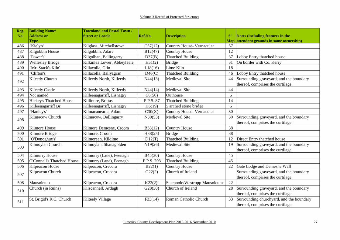
486 'Kiely's' Kilglass, Mitchellstown C57(12) Country House- Vernacular 57487 Kilgobbin House Kilgobbin, Adare B12(47) Country House 12488 'Power's' Kilgolban, Ballingarry D37(B) Thatched Building 37 Lobby Entry thatched house489 Wellesley Bridge Kilkinlea Lower, Abbeyfeale H51(2) Bridge 51 On border with Co. Kerry490 'Mr. Stack's Kiln' Killacolla, Glin L18(16) Lime Kiln 18491 'Clifton's' Killacolla, Ballyagran D46(C) Thatched Building 46 Lobby Entry thatched house
492 Kileedy Church Killeedy North, Killeedy N44(13) Medieval Site 44 Surrounding graveyard, and the boundary thereof, comprises the curtilage.
493 Kileedy Castle Killeedy North, Killeedy N44(14) Medieval Site 44494 Not named Killeenagarriff, Lisnagry C6(50) Outhouse 6495 Hickey's Thatched House Killinure, Brittas P.P.S. 87 Thatched Building 14496 Killeenagarriff Br. Killeenagarriff, Lisnagry H6(19) 5 arched stone bridge 6497 'Hanley's' Kilmacanearla, Adare C30(X) Country House- Vernacular 30
498 Kilmacow Church Kilmacow, Ballingarry N30(53) Medieval Site 30 Surrounding graveyard, and the boundary thereof, comprises the curtilage.
499 Kilmore House Kilmore Demesne, Croom B38(12) Country House 38500 Kilmore Bridge Kilmore, Croom H38(25) Bridge 38501 'O'Donoghue's' Kilmoreen, Kildimo D12(T) Thatched Building 12 Direct Entry thatched house
503 Kilmoylan Church Kilmoylan, Shanagolden N19(26) Medieval Site 19 Surrounding graveyard, and the boundary thereof, comprises the curtilage.
504 Kilmurry House Kilmurry (Lane), Feenagh B45(30) Country House 45505 O'Connell's Thatched House Kilmurry (Lane), Feenagh P.P.S. 203 Thatched Building 46506 Kilpeacon House Kilpeacon, Crecora B22(1) Country House 22 Gate Lodge and Demesne Wall
507 Kilpeacon Church Kilpeacon, Crecora G22(2) Church of Ireland Surrounding graveyard, and the boundary thereof, comprises the curtilage.
508 Mausoleum Kilpeacon, Crecora K22(2)i Stacpoole/Westropp Mausoleum 22
510 Church (in Ruins) Kilscannell, Ardagh G28(30) Church of Ireland 28 Surrounding graveyard, and the boundary thereof, comprises the curtilage.
511 St. Brigid's R.C. Church Kilteely Village F33(14) Roman Catholic Church 33 Surrounding churchyard, and the boundary thereof, comprises the curtilage.

Volume 3 Record of Protected Structures
Limerick County Development Plan 2010-2016 November 2010 28
Reg.No.
Building Name/Address orType
Townland and Postal Town /Street or Locale Ref.No. Description 6"
Map Notes (including features in the attendant grounds in same ownership)
512 'Mr. Behan's Kiln' Kilteery, Glin L9(13) Lime Kiln 9513 'Mr.O'Shaughnessy's Kiln' Kilteery, Glin L9(14) Lime Kiln 9514 'Mr. Sheahan's Kiln' Kilteery, Glin L9(16) Lime Kiln 9515 New Pier Kilteery, Loughil P.P.S. 28 Coastal infrastructure 9
516NONE Kiltenan North, Croagh P.P.S. 155 Vernacular farmhouse,
associated farmyard and 30
517 'Mr.Hanrahan's Kiln' Kinnard, Glin L17(26) Lime Kiln 17
518 'Mr. Cregan's Kiln' Kinnard, Glin L17(27) Lime Kiln 17
519 Kishyquirk Schools Kishykirk, Ballysimon L14(50) Institutional- School 14 One is now in use as a private dwelling while the second is a holiday home.
520 Knockaderry House Knockaderry, Newcastle West B36(17) Country House 40521 Knockainy Stud Knockainy West, Hospital B40(19) Country House 40522 'Fitzgerald's' Knockainy West, Hospital D32(D) Thatched Building 32 Lobby Entry thatched house523 'O'Shea's' Knockananty, Ballysimon D13(F) Thatched Building 13 Lobby Entry thatched house
524 'Toomey's' Knockanes, Adare D21(Q) Thatched Building 21 Direct Entry thatched house- rare double leafdoorway
525 'Fitzgerald's' Knockasna, Abbeyfeale C42(X) Country House- Vernacular 42526 Caherelly Cottage Knockcorragh, Grange B23(15) Country House 23528 'Liston's' Knockdromin, Croagh D20(H) Thatched Building 20 Direct Entry thatched house529 Not named Knocklong West, Knocklong F41(5) Roman Catholic Church 41530 O'Hurley's Castle Knocklong East, Knocklong N41(5) Medieval Site 41
532 'De Valera Cottage' Knockmore, Bruree C39(39) Country House- Labourer's 39 The Coll family home where Eamon De Valerawas raised.
533 Uregare Church Knockuregare, Bruff N39(37) Medieval Site 39 Surrounding graveyard, and the boundary thereof, comprises the curtilage.
534 Farm Lodge Kyleavarraga Middle, Adare P.P.S. 122 Country House Feature 20 May have associations with the Currahchase estate
535 Worldsend Lacka, Castleconnell B1(10) Country House 1

Volume 3 Record of Protected Structures
Limerick County Development Plan 2010-2016 November 2010 29
Reg.No.
Building Name/Address orType
Townland and Postal Town /Street or Locale Ref.No. Description 6"
Map Notes (including features in the attendant grounds in same ownership)
536 'Brosnan's' Lacka (E.D. Rathmore), Croom
D31(B) Thatched Building 31 Lobby Entry thatched house
537 Cahervally House Lemonfield, Patrickswell B13(15) Country House- [Former] Rectory 13 Gate Lodge included
538 Lickadoon Castle / House Lickadoon, Roxborough P.P.S. 77 Georgian era Country Houseand associated features
13
539 NONE Lickadoon, Roxborough P.P.S. 78 Former Master's House 13
540 Linfield House Linfield, Pallasgreen B24(5) Country House 24 Large walled garden and extensive outbuildings, Lodge on roadside included.
541 'Lee's' Lisduane, Granagh D38(G) Thatched Building 38 Lobby Entry thatched house542 Betty Ville House Lismakeery, Askeaton B19(45) Country House 19543 Lismullane House Lismullane, Ballysimon B14(49) Country House 14544 Lisnacullia Castle Lisnacullia, Ardagh N28(34) Medieval Site- Castle 28545 Caherline House Lisnagry Townland, Lisnagry P.P.S. 20 Victorian period house 6 Gate Lodge included
546 Lodge Lisnagry Townland, Lisnagry P.P.S. 21 Former Gate Lodge [Mount Shannon]
6 Feature in attendant grounds ofprotected structure
547 'Shanahan's' Lisnamuck, Rathkeale D20(D) Thatched Building 20 Direct Entry thatched house548 Lissamota Castle Lissamota, Ballingarry N29(31) Medieval Site- Castle 29549 Lissatotan Lissatotan, Rathkeale B19(30) Country House 19 Turreted castle in stone
551 'Nestor's' Lissatotan / Ranahan,Rathkeale
D19(D) Thatched Building 19 Direct Entry thatched house
553 Loghill Bridge Loghill/Carrowbane Beg, Glin H9(8) Bridge 9554 Carrowbane Bridge Loghill/Carrowbane Beg, Glin H9(15) Bridge 9555 Loghill Church Loghill, Glin N9(5) Medieval Site- Church 9 Surrounding graveyard, and the boundary
556 Church Loghill, Glin G9(1) Church of Ireland Surrounding graveyard, and the boundary thereof, comprises the curtilage.
557 Lombardstown House Lombardstown, Caherline B23(4) Country House 23558 Bruree Castle Lotteragh Upper, Bruree N39(12)A Medieval Site 39559 Glebe Castle Lotteragh Lower, Bruree N39(12)B Medieval Site 39560 Bruree Creamery Lotteragh Upper, Bruree P.P.S. 184 Industrial infrastructure 39 Social and Cultural significance561 Lake View Lough Gur, Bruff B32(48) Country House 32

Volume 3 Record of Protected Structures
Limerick County Development Plan 2010-2016 November 2010 30
Reg.No.
Building Name/Address orType
Townland and Postal Town /Street or Locale Ref.No. Description 6"
Map Notes (including features in the attendant grounds in same ownership)
562 'Pinschmidt's' Lough Gur, Bruff D32(B) Thatched Building 32 Direct Entry thatched house
563 Lough Gur Visitor Centre
Lough Gur, Bruff L32(48) Industrial and Institutional- Visitor Centre
32 Lime Kiln also included
564 Bourchiers Castle Lough Gur, Bruff N32(47) Medieval Site 32565 Black Castle Lough Gur, Bruff N32(76) Medieval Site 32
566 New Church Lough Gur, Bruff N32(46) Medieval Site 32 Surrounding graveyard, and the boundary thereof, comprises the curtilage.
567 'O'Donnell's' Loughanstown, Fedamore D22(D) Thatched Building 22 Lobby Entry thatched house- unusual thatchedporch
568 Ludden Church Luddenbeg, Ballyneety N14(1) Medieval Site 14 Surrounding graveyard, and the boundary thereof, comprises the curtilage.
569 'Curtin's' Lurraga, Patrickswell D12(E) Thatched Building 12 Unclassified
571 Castle Mahon Mahoonagh More, Newcastle West
B36(22) Country House- Vernacular 36 Adjacent Castle
573 Mahoonagh Church Mahoonagh, Newcastle West N36(13) Medieval Site 36 Surrounding graveyard, and the boundary thereof, comprises the curtilage.
574 R.C. Church Maonoola, Oola F25(5) Roman Catholic Church 25
575 Maidstown Castle & Maidstone House
Maidstown, Kilmallock B/N39(35) Medieval Site 39 Coach House and Stables of Maidstone House included.
576 Church Martinstown, Kilmallock F48(34) Roman Catholic Church 48577 Mary Ville Maryville, Croom B22(15) Country House 22
578 R.C. Church Meanus, Kilmallock F31(17) Roman Catholic Church 31 Surrounding graveyard, and the boundary thereof, comprises the curtilage.
579 Mellon House Mellon, Kildimo B4(19) Country House 4 Very good small Demesne
580 Ardcanny Church Mellon, Kildimo G4(3) Church of Ireland 4 Surrounding graveyard, and the boundary thereof, comprises the curtilage.
581 Millough House Milltown, Pallaskenry B11(4) Country House 11582 Milltown House Milltown, Bruff B40(10) Country House 40
583 Ryan's Thatched House Mitchelstowndown North, Knocklong
D48(D) Thatched Building 48 Lobby Entry thatched house
Volume 3 Record of Protected Structures
Limerick County Development Plan 2010-2016 November 2010 31
Reg.No.
Building Name/Address orType
Townland and Postal Town /Street or Locale Ref.No. Description 6"
Map Notes (including features in the attendant grounds in same ownership)
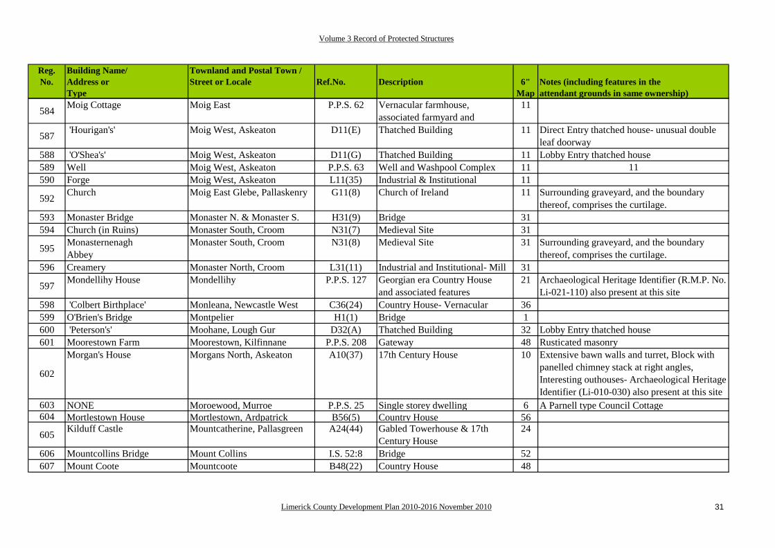
584 Moig Cottage Moig East P.P.S. 62 Vernacular farmhouse, associated farmyard and
11
587 'Hourigan's' Moig West, Askeaton D11(E) Thatched Building 11 Direct Entry thatched house- unusual double leaf doorway
588 'O'Shea's' Moig West, Askeaton D11(G) Thatched Building 11 Lobby Entry thatched house589 Well Moig West, Askeaton P.P.S. 63 Well and Washpool Complex 11 11590 Forge Moig West, Askeaton L11(35) Industrial & Institutional 11
592 Church Moig East Glebe, Pallaskenry G11(8) Church of Ireland 11 Surrounding graveyard, and the boundary thereof, comprises the curtilage.
593 Monaster Bridge Monaster N. & Monaster S. H31(9) Bridge 31594 Church (in Ruins) Monaster South, Croom N31(7) Medieval Site 31
595 MonasternenaghAbbey
Monaster South, Croom N31(8) Medieval Site 31 Surrounding graveyard, and the boundary thereof, comprises the curtilage.
596 Creamery Monaster North, Croom L31(11) Industrial and Institutional- Mill 31
597 Mondellihy House Mondellihy P.P.S. 127 Georgian era Country Houseand associated features
21 Archaeological Heritage Identifier (R.M.P. No. Li-021-110) also present at this site
598 'Colbert Birthplace' Monleana, Newcastle West C36(24) Country House- Vernacular 36599 O'Brien's Bridge Montpelier H1(1) Bridge 1600 'Peterson's' Moohane, Lough Gur D32(A) Thatched Building 32 Lobby Entry thatched house601 Moorestown Farm Moorestown, Kilfinnane P.P.S. 208 Gateway 48 Rusticated masonry
602
Morgan's House Morgans North, Askeaton A10(37) 17th Century House 10 Extensive bawn walls and turret, Block with panelled chimney stack at right angles, Interesting outhouses- Archaeological Heritage Identifier (Li-010-030) also present at this site
603 NONE Moroewood, Murroe P.P.S. 25 Single storey dwelling 6 A Parnell type Council Cottage604 Mortlestown House Mortlestown, Ardpatrick B56(5) Country House 56
605 Kilduff Castle Mountcatherine, Pallasgreen A24(44) Gabled Towerhouse & 17thCentury House
24
606 Mountcollins Bridge Mount Collins I.S. 52:8 Bridge 52607 Mount Coote Mountcoote B48(22) Country House 48

Volume 3 Record of Protected Structures
Limerick County Development Plan 2010-2016 November 2010 32
Reg.No.
Building Name/Address orType
Townland and Postal Town /Street or Locale Ref.No. Description 6"
Map Notes (including features in the attendant grounds in same ownership)
608 Mount Pleasant Mountpleasant, Kildimo B4(2) Country House 4609 Mount Shannon Mountshannon, Lisnagry B6(27) Country House 6 Ice House used as Mausoleum (See below)610 Nevins Mausoleum Mountshannon, Lisnagry K6(48) Mausoleum 6611 Mountsion House Mountsion, Pallasgreen B24(10) Country House 24 Good Gateway
612 Mount Trenchard Mounttrenchard, Foynes B9(3) Country House 9 Good outhouses, Gate Lodge and the later Convent School extensions also included
613 NONE Mounttrenchard P.P.S. 30 Victorian period schoolhouse 9 Former Agricultural School614 'Sea Wall' Mounttrenchard P.P.S. 29 Coastal infrastructure 9 615 Rectory or Pallas Glebe Moymore, Pallasgreen B24(28) Country House 24616 Movena House Mullagh, Shanagolden. B19(46) Country House 19 617 Nutgrove Flour Mill (in Ruins)Mullagh, Shanagolden. L19(43) Industrial & Institutional- Mill 19 Includes Mill Race618 Nutgrove School Mullagh, Shanagolden. L19(29) Industrial & Institutional- School 19619 Nantinan House Nantinan, Askeaton. B20(12) Country House 20 Large 18th C. Piers with Gates
620 Church Nantinan, Askeaton. G20(11) Church of Ireland 20 Surrounding graveyard, and the boundary thereof, comprises the curtilage.
623 'Ward's' Newtown, Askeaton D11(F) Thatched Building 11 Direct Entry thatched house- unusual Plan Form
624 'Roberts's' Newtown, Clarina D4(A) Thatched Building 4 One and a half Storey Lobby Entry thatched house
625 'Kenny's' Newtown, Clarina D4(B) Thatched Building 4 Lobby Entry thatched house
626 'Magill's' Newtown, Clarina D4(C) Thatched Building 4 Conversion to a Thatched House from Councildesign based on the Direct Entry type
627 'Hacket's' Newtown, Clarina D4(E) Thatched Building 4 Lobby Entry thatched house
628 St.Margaret's Church Newtown, Clarina N4(44) Medieval Site- Church 4 Surrounding graveyard, and the boundary thereof, comprises the curtilage.
630 'Leahy's' Newtown, Elton D40(A) Thatched Building 40 Lobby Entry thatched house631 R.C.. Church Nicker, Pallasgreen F24(31) Roman Catholic Church 24
632 Monaster na Gallaigh Oldabbey, Shanagolden. N19(22) Medieval Site- Abbey 19 Surrounding graveyard, and the boundary thereof, comprises the curtilage.
633 'Foley's' Oldtown (Ryan), Hospital D33(X) Thatched Building 33 Lobby Entry thatched house635 Mausoleum Pallas, Old Pallas K24(24) Scott Mausoleum 24 Dates to 1851.
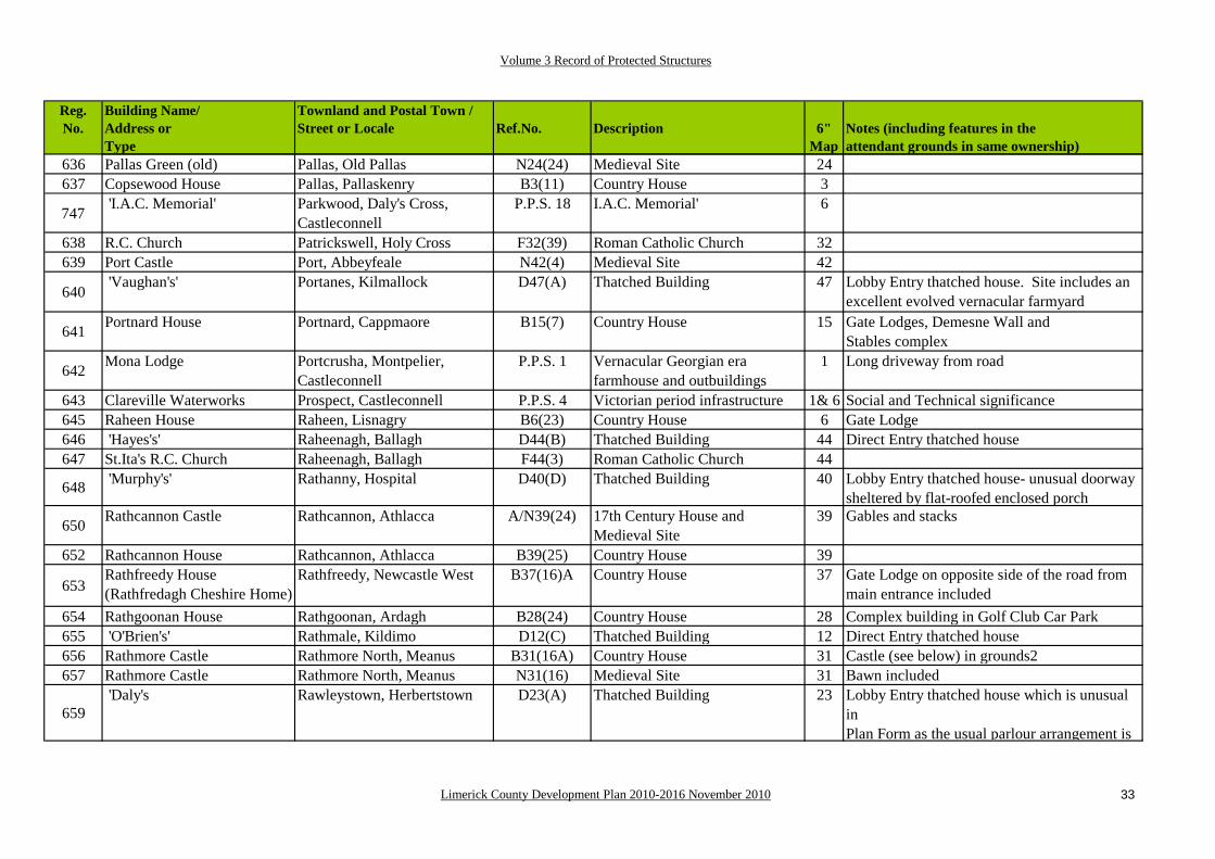
Volume 3 Record of Protected Structures
Limerick County Development Plan 2010-2016 November 2010 33
Reg.No.
Building Name/Address orType
Townland and Postal Town /Street or Locale Ref.No. Description 6"
Map Notes (including features in the attendant grounds in same ownership)
636 Pallas Green (old) Pallas, Old Pallas N24(24) Medieval Site 24637 Copsewood House Pallas, Pallaskenry B3(11) Country House 3
747 'I.A.C. Memorial' Parkwood, Daly's Cross, Castleconnell
P.P.S. 18 I.A.C. Memorial' 6
638 R.C. Church Patrickswell, Holy Cross F32(39) Roman Catholic Church 32639 Port Castle Port, Abbeyfeale N42(4) Medieval Site 42
640 'Vaughan's' Portanes, Kilmallock D47(A) Thatched Building 47 Lobby Entry thatched house. Site includes an
excellent evolved vernacular farmyard
641 Portnard House Portnard, Cappmaore B15(7) Country House 15 Gate Lodges, Demesne Wall andStables complex
642 Mona Lodge Portcrusha, Montpelier, Castleconnell
P.P.S. 1 Vernacular Georgian era farmhouse and outbuildings
1 Long driveway from road
643 Clareville Waterworks Prospect, Castleconnell P.P.S. 4 Victorian period infrastructure 1& 6 Social and Technical significance645 Raheen House Raheen, Lisnagry B6(23) Country House 6 Gate Lodge646 'Hayes's' Raheenagh, Ballagh D44(B) Thatched Building 44 Direct Entry thatched house647 St.Ita's R.C. Church Raheenagh, Ballagh F44(3) Roman Catholic Church 44
648 'Murphy's' Rathanny, Hospital D40(D) Thatched Building 40 Lobby Entry thatched house- unusual doorwaysheltered by flat-roofed enclosed porch
650 Rathcannon Castle Rathcannon, Athlacca A/N39(24) 17th Century House and Medieval Site
39 Gables and stacks
652 Rathcannon House Rathcannon, Athlacca B39(25) Country House 39
653Rathfreedy House (Rathfredagh Cheshire Home)
Rathfreedy, Newcastle West B37(16)A Country House 37 Gate Lodge on opposite side of the road from main entrance included
654 Rathgoonan House Rathgoonan, Ardagh B28(24) Country House 28 Complex building in Golf Club Car Park655 'O'Brien's' Rathmale, Kildimo D12(C) Thatched Building 12 Direct Entry thatched house656 Rathmore Castle Rathmore North, Meanus B31(16A) Country House 31 Castle (see below) in grounds2657 Rathmore Castle Rathmore North, Meanus N31(16) Medieval Site 31 Bawn included
659 'Daly's Rawleystown, Herbertstown D23(A) Thatched Building 23 Lobby Entry thatched house which is unusual
inPlan Form as the usual parlour arrangement is

Volume 3 Record of Protected Structures
Limerick County Development Plan 2010-2016 November 2010 34
Reg.No.
Building Name/Address orType
Townland and Postal Town /Street or Locale Ref.No. Description 6"
Map Notes (including features in the attendant grounds in same ownership)
660 Rawleystown Court Rawleystown, Herbertstown A23(18) 17th Century House 32 Featureless bawn walls661 'Scanlan's' Raymondstown, Bruff D39(F) Thatched Building 39 Direct Entry thatched house662 Reens House Reens West, Rathkeale B28(33) Country House 28663 Rich Hill House Richhill, Lisnagry B6(22) Country House 6 Older house behind664 Richhill School Richhill, Lisnagry P.P.S. 22 Victorian period schoolhouse 6 Victorian Gothick design665 Riddlestown Park Riddlestown, Rathkeale B20(31) Country House 19
666 NONE Rineroe, Adare P.P.S. 131 Vernacular farmhouse, associated farmyard and
21
667 Robertstown Robertstown, Foynes N10(23) Medieval Site 10668 St.Robert's R.C. Ch. Robertstown, Foynes F10(22) Roman Catholic Church 10
669 Rockbarton House Rockbarton, Holy Cross B31(26) Country House 31 Gate Lodge, Stables and Demesne Wall
670 Rockbarton House Rockbarton, Holy Cross B31(26)A Country House Stables 31671 R.C. Church Rockfarm, Caherline F23(12) Roman Catholic Church 23672 NONE Rockfarm, Caherline P.P.S. 140 Public House 23 'The Tower Bar', L23(8) refers673 Rockfield House Rockfield, Crecora B22(44) Country House 22 May incorporate older house
674 Rockstown Church Rockstown, Ballyneety N22(34) Medieval Site 22 Castle, Medieval Church, Mausoleum, each with seperate entry
676 Rockstown House Rockstown, Fedamore B22(35A) Country House 22
677 Kelly Mausoleum Rockstown, Fedamore K22(34) Mausoleum 22 Surrounding graveyard, and the boundary thereof, comprises the curtilage.
678 Roxborough Sch[ool] Roxborough, Limerick L13(23) Industrial & Institutional- School 13679 Lodge Ryves Castle, Knocklong P.P.S. 191 Estate Feature- Gate Lodge A 41 Wing walls and piers included680 Lodge Ryves Castle, Knocklong P.P.S. 192 Estate Feature- Gate Lodge B 41 Wing walls and piers included681 Ryves Castle Ryves Castle, Knocklong P.P.S. 193 Estate Features- hard 41682 Ryves Mausoleum Ryves Castle, Knocklong K41(2) Mausoleum & Obelisk 41 Surrounding graveyard, and the boundary
683 "Pa McGrath's" Sandylane, Boher D14(C) Thatched Building 14 Thatched Public House- Lobby Entry Plan684 "M. O'Neill's" Sandylane, Boher D14(D) Thatched Building 14 Thatched Public House- Lobby Entry Plan685 Unknown Sandylane, Boher D14(F) Thatched Building 14686 St. Patricks R.C. Church Sandylane, Boher F14(43) Roman Catholic Church 14
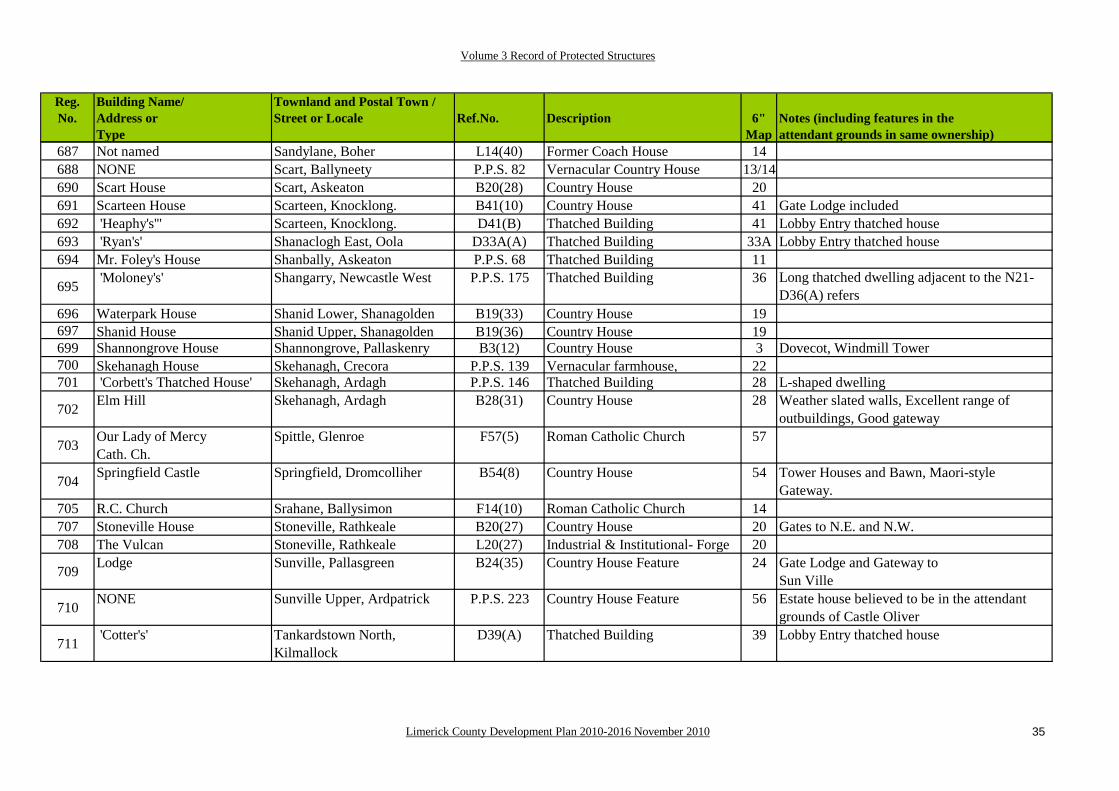
Volume 3 Record of Protected Structures
Limerick County Development Plan 2010-2016 November 2010 35
Reg.No.
Building Name/Address orType
Townland and Postal Town /Street or Locale Ref.No. Description 6"
Map Notes (including features in the attendant grounds in same ownership)
687 Not named Sandylane, Boher L14(40) Former Coach House 14688 NONE Scart, Ballyneety P.P.S. 82 Vernacular Country House 13/14 690 Scart House Scart, Askeaton B20(28) Country House 20691 Scarteen House Scarteen, Knocklong. B41(10) Country House 41 Gate Lodge included692 'Heaphy's'" Scarteen, Knocklong. D41(B) Thatched Building 41 Lobby Entry thatched house693 'Ryan's' Shanaclogh East, Oola D33A(A) Thatched Building 33A Lobby Entry thatched house694 Mr. Foley's House Shanbally, Askeaton P.P.S. 68 Thatched Building 11
695 'Moloney's' Shangarry, Newcastle West P.P.S. 175 Thatched Building 36 Long thatched dwelling adjacent to the N21- D36(A) refers
696 Waterpark House Shanid Lower, Shanagolden B19(33) Country House 19697 Shanid House Shanid Upper, Shanagolden B19(36) Country House 19699 Shannongrove House Shannongrove, Pallaskenry B3(12) Country House 3 Dovecot, Windmill Tower700 Skehanagh House Skehanagh, Crecora P.P.S. 139 Vernacular farmhouse, 22701 'Corbett's Thatched House' Skehanagh, Ardagh P.P.S. 146 Thatched Building 28 L-shaped dwelling
702 Elm Hill Skehanagh, Ardagh B28(31) Country House 28 Weather slated walls, Excellent range of outbuildings, Good gateway
703 Our Lady of MercyCath. Ch.
Spittle, Glenroe F57(5) Roman Catholic Church 57
704 Springfield Castle Springfield, Dromcolliher B54(8) Country House 54 Tower Houses and Bawn, Maori-style Gateway.
705 R.C. Church Srahane, Ballysimon F14(10) Roman Catholic Church 14707 Stoneville House Stoneville, Rathkeale B20(27) Country House 20 Gates to N.E. and N.W. 708 The Vulcan Stoneville, Rathkeale L20(27) Industrial & Institutional- Forge 20
709 Lodge Sunville, Pallasgreen B24(35) Country House Feature 24 Gate Lodge and Gateway to Sun Ville
710 NONE Sunville Upper, Ardpatrick P.P.S. 223 Country House Feature 56 Estate house believed to be in the attendant grounds of Castle Oliver
711 'Cotter's' Tankardstown North, Kilmallock
D39(A) Thatched Building 39 Lobby Entry thatched house

Volume 3 Record of Protected Structures
Limerick County Development Plan 2010-2016 November 2010 36
Reg.No.
Building Name/Address orType
Townland and Postal Town /Street or Locale Ref.No. Description 6"
Map Notes (including features in the attendant grounds in same ownership)
712 Tankardstown Church Tankardstown South, Kilmallock
N47(24) Medieval Site 47
713 'Manning's' Teernahilla, Ballingarry D37(D) Thatched Building 37 Lobby Entry thatched house
714 Church Templeglentan East, Templeglentine
F43(8) Roman Catholic Church 43
715 Boskill House Templemichael, Caherconlish B14(22) Country House Feature 14 Gate Lodge to the now demolished Boskill House.
716 School (Girls) Tervoe, Clarina L4(17) Industrial & Institutional- School 4717 Cross Tervoe, Clarina L12(21) Industrial & Institutional 12 Wayside Memorial
719 Thornfield House Thornfield, Lisnagry B6(24) Country House 6 Extensive outbuildings and unspoilt attendant lands and setting.
720 'O'Malley's' Toberagarriff, Murroe D6(A) Thatched Building 6 Lobby Entry thatched house
722 Tomdeeley Castle Tomdeeley North, Askeaton A/N10(34) 17th Century House 10 Church, Earthworks and ruinousfortifications in the Castle's vicinity.
724 Tomdeely Church Tomdeely North, Askeaton N10 (34) Medieval Site- Church 10725 Railway Bridge Tomdeely South P.P.S. 61 Railway feature 10 726 Toomaline House Toomaline Lower, Doon B16(10) Country House 16 May have been Augustinian Priory727 'Mr. Costello's 1st Kiln' Tooraree Lower, Glin L18(21) Lime Kiln 18728 'Mr. Costello's 2nd Kiln' Tooraree Lower, Glin L18(22) Lime Kiln 18729 'Mr. Sheehy's Kiln' Tooraree Lower, Glin L18(23) Lime Kiln 18730 'Mr. Culhane's Kiln' Tooraree Lower, Glin L18(24) Lime Kiln 18731 'Mr. White's Kiln' Tooraree Upper, Glin L18(25) Lime Kiln 18732 'Mr. Geoghegan's Kiln' Tooraree Upper, Glin L18/27 Lime Kiln 18/27733 Islandmore Tooreen, Croom B30(1) Country House 30 Gate Lodges, ornamental bridges734 Church Toornafulla, Newcastle West F43 (14) Roman Catholic Church 43735 Castle Ievers Tullerboy, Athlacca B31(1) Country House 31 Incorporates part of Tullaboy Castle
736Devonroad Station Tulligoline South,
TempleglantineP.P.S. 194 Railway Station 43 Railway Infrastructure
737 Tullovin Castle Tullovin, Athlacca N31(4) Medieval Site 31738 'Ruddle's' Tullyleague, Glin B17(18) Country House 17

Volume 3 Record of Protected Structures
Limerick County Development Plan 2010-2016 November 2010 37
Reg.No.
Building Name/Address orType
Townland and Postal Town /Street or Locale Ref.No. Description 6"
Map Notes (including features in the attendant grounds in same ownership)
739 'Mr.Storan's Kiln' Tullyleague, Glin L17(29) Lime Kiln 17740 'Mr.Cregan's Kiln' Tullyleague, Glin L17(30) Lime Kiln 17742 'Mr. Culhane's Kiln' Tullyleague, Glin L17(28) Lime Kiln 17743 Treacy's Thatched House Tuogh, Adare P.P.S. 124 Thatched Dwelling 21
744 Tuogh Church Tuogh, Cappamore N15(17) Medieval Site 15 Surrounding graveyard, and the boundary thereof, comprises the curtilage.
746 Woodpark House Woodpark, Daly's Cross,Castleconnell
P.P.S. 2 Georgian era Country Houseand associated features
1
748 Woodstown House Woodstown, Lisnagry P.P.S. 23 Victorian period house 6 Gate Lodge, demesne features,modern Vatican II chapel
1697 'Ard Mhuire' Kimeheer, Old Abbey Road,
ShanagoldenP.P.S. 2010-
001Former Roman Catholic Presbytery & associated outbuildings
1698St Patricks Roman Catholic Church
Anglesborough, Kilmallock F57(11) Roman Catholic Church 57
1699 Ballynoe Castle Balynoe West, Castlemahon N37(14) Castle Ruins 371700 Ballyagran Cottage Ballyagran, Kilmallock. B46(5) Country House 461701 Banoge Cottage Ballynabanogue, Croom B30(4) Cottage 30

Volume 3 Record of Protected Structures
Limerick County Development Plan 2010-2016 November 2010 38
Reg.No.
Building Name/Address orType
Townland and Postal Town /Street or Locale Ref.No. Description 6"
Map Notes (including features in the attendant grounds in same ownership)
TOWN, VILLAGE & URBAN AREAS Abbeyfeale
750 Allaghaun Bridge Abbeyfeale West H42(2) Bridge 42751 P.M. Aherne New Street P.P.S. 380 Commercial Premises 42752 Teach na Féile New Street / Athea Road ABF-18 Former Schoolhouse 42 Now in use as Community Centre753 Wards New Street / Athea Road ABF-19 Former Commercial Premises 42 Timber fascia board and display window754 Harnett's Shop New Street / Athea Road ABF-20 Former Commercial Premises 42 Stucco Shopfront755 O'Connell's Shop New Street / Athea Road ABF-21 Commercial Premises 42 Stucco Shopfront756 O'Connell's Bar & Grocery New Street / Athea Road ABF-22 Commercial Premises 42 Vitrolite and Chrome Shopfront757 Lane's Shop New Street / Athea Road ABF-23 Commercial Premises 42 Stucco Shopfront758 Kissane-O'Donovan' New Street / Athea Road M42M(19) Commercial Premises 42 Stucco Shopfront759 J.D.Hartnett New Street / Athea Road ABF-08 Commercial Premises 42 Stucco Shopfront760 Cryle Dry Cleaners' New Street / Athea Road M42M(34) Previously O'Mara's 42 Intricate Stucco Shopfront761 Not named New Street / Athea Road ABF-24 Former Commercial Premises 42 Stucco detailing on façade
762 Convent of Mercy Limerick Road M42M(31) Institutional Building 42 Stucco embrasures around opes, Fine Chapel with wing for lay people
763 Roche New Street / Athea Road M42M(15a) Commercial Premises 42 Stucco detailing, including lettering.764 McMahon's Shop- Façade Limerick Road ABF-50 Commercial Premises 42 Stucco detailing on façade765 M.J. Maloney' New Street / Athea Road M42M(15) Commercial Premises 42 Intricate Stucco Shopfront766 Abbey Cinema Façade Limerick Road ABF-15 Former Commercial Premises 42 Art Deco 767 McEnery's Bar Main Street ABF-51 Commercial Premises 42 Good Stucco detailing768 Flix and Mix- Façade Main Street ABF-55 Commercial Premises 42 Stucco Shopfront769 Abbey Bar- Façade Main Street ABF-53 Commercial Premises 42 Stucco detailing on façade
770 J.D. Daly's Main Street M42M(9) Commercial Premises 42 Intricate Stucco detailing, including lettering, on the façade
771 Donal & Ann's Diner- Façade Main Street ABF-54 Commercial Premises 42 Intricate Stucco Shopfront772 Ann's Diner- Façade Main Street ABF-56 Commercial Premises 42 Stucco Shopfront773 O'Sullivan's- Façade Main Street ABF-57 Commercial Premises 42 Intricate Stucco Shopfront

Volume 3 Record of Protected Structures
Limerick County Development Plan 2010-2016 November 2010 39
Reg.No.
Building Name/Address orType
Townland and Postal Town /Street or Locale Ref.No. Description 6"
Map Notes (including features in the attendant grounds in same ownership)
774 Fuschia Hair and Beauty Main Street ABF-58 Commercial Premises 42 Timber Shopfront and curved glass display windows, Good Stucco work.
775 Murphy's Bar Main Street ABF-59 Commercial Premises 42 Stucco detailing on the façade
776Cistercian Abbey The Square M42M(32) Medieval Site- Cell 42 Foundation of 1188- Surrounding graveyard,
and the boundary thereof, comprises the curtilage.
777
O'Connor's' Main Street M42M(7) Commercial Premises 42 Now divided amongst several firms, this is one of the finest examples of'Celtic Revival' art as exemplifed by the stucco work undertaken by Pat M
778 Provincial House Main Street ABF-26 Commercial Premises 42 Formerly the Abbeyfeale branch of the Provincial Bank of Ireland
779"Eccleston's"' Main Street and New Street M42M33) Commercial Premises 42 Now divided amongst two firms this is a
strong building in a prominent corner site with stucco detailing on its façades.
780 Not named Main Street M42M(1)/ABF-28
Former Commercial Premises, known as 'O'Connell's' Bar'
42 Folk Art interpretation of Viking styleornamentation
781 Bobby's Bar- Façade Main Street ABF-29 Commercial Premises 42 Stucco detailing on the façade782 D.P. Ahern New Street M42 M(13) Commercial Premises 42 Stucco Shopfront783 "The Bobbin Case" Market Square ABF-31 Commercial Premises 42 Stucco detailing on the façade784 Kerry Bar- Façade Main Street ABF-32 Commercial Premises 42 Stucco detailing on the façade785 Adrenalin Main Street ABF-43 Commercial Premises 42 Brick fronted building- one of a pair786 Harnett Main Street ABF-43 Commercial Premises 42 Brick fronted building- second of two787 Stack Auctioneers Market Square ABF-47 Commercial Premises 42 Stucco detailing on façade
788 O'Connell's' Market Square ABF-29 Commercial Premises 42 Cast iron casement windows give thisbuilding a distinctive appearance
789 A.I.B. Main Street ABF-40 Commercial Premises 42 Elegant façade based on classical design

Volume 3 Record of Protected Structures
Limerick County Development Plan 2010-2016 November 2010 40
Reg.No.
Building Name/Address orType
Townland and Postal Town /Street or Locale Ref.No. Description 6"
Map Notes (including features in the attendant grounds in same ownership)
790Leens Hotel Main Street ABF-41 Commercial Premises 42 Three storey building with good
fenestration patterns and stucco detailing on the façade.
792 Fr. Casey Statue Market Square M42M(4) Civic Structure 42 Bronze statue on granite base with commemerative plaques in bronze on the faces
793 D. O'Connell Market Square M42M(1) Commercial Premises 42 Cast iron casement windows, on the first floor, give this building a distinctive appearance
794 The Vegetable Shop Market Square ABF-38 Commercial Premises 42 Stucco Shopfront795 Paddy Power's Market Square ABF-37 Commercial Premises 42 Timber Shopfront (new)796 O'Rourke's Bar Market Square ABF-36 Commercial Premises 42 Timber Shopfront (new)797 The Cellar Bar Market Square ABF-31 Commercial Premises 42 Stucco detailing on the façades798 Funeral Home Off Market Street ABF-35 Commercial Premises 42 Stucco detailing around window opes.
799 Not named Limerick Road P.P.S. 383 Bungalow 42 Constructed in red brick- a good example of its type
800 Not named Bridge Street M42M(3) Formerly the Post Office 42 Stucco shopfront and detailing801 Not named Bridge Street ABF-32 Former Commercial Premises 42802 Not named Bridge Street ABF-33 Private Dwelling 42803 O'Connor Solicitors Bridge Street ABF-30 Commercial Premises 42 Stucco Shopfront804 Begley's Bridge Street ABF-25 Commercial Premises 42 Stucco detailing
805Maloney's Garage- façade Bridge Street ABF-34 Commercial Premises 42 Vernacular interpretation of Modern
Movement architectural style806 Courthouse Bridge Street M42M(29) Urban Structure- Civic 42 Houses the Abbeyfeale Library Branch807 M.D.Ahern' Bridge Street M42M(28) Commercial Premises 42 Now the Credit Union premises
808Feale Ville Bridge Street ABF-56 Dwelling 42 3 bay 2 storey house with bay windows
rising through both floors flanking the centrally placed doorway.
1695 Tobins Main Street, Abbeyfeale ABF-48 Urban Dwelling 42 Terraced 3 bay dwelling with ornamental plaster on front façade
1696 O' Connells Market Square M42M(3)A Terraced Dwelling 421702 P Downey New Street, Abbeyfeale ABF-E Former Commerical Premises 42 2 bay 2 storey, stucco detail over shop

Volume 3 Record of Protected Structures
Limerick County Development Plan 2010-2016 November 2010 41
Reg.No.
Building Name/Address orType
Townland and Postal Town /Street or Locale Ref.No. Description 6"
Map Notes (including features in the attendant grounds in same ownership)
Adare
809
Adare Manor House Adare Townland B/M21(9) Country House 21 Ornamental grounds with bridges,gardens, ice house, pigeon housestables complex and staff houses, many of which are identified individually in the R.P.S.
810
Limerick Lodge Adare Townland M21(21) Country House feature- Gate Lodge
21 Known locally as the Lantern Lodge, this feature signals to the traveller that s/he is arriving into a place of considered, and considerable, architectural interest and significance
811 Not named Various townlands P.P.S. 296 Demesne Wall 21812 Castle Desmond Bridge Adare Townland P.P.S. 297 Bridge 21 In the attendant grounds of Adare Manor813 Modified Medieval Site Adare Townland P.P.S. 298 Dovecot 21 In the attendant grounds of Adare Manor
814Estate Feature Adare Townland P.P.S. 299 'Rent House' 21 In the attendant grounds of Adare Manor-
an early example of 'Gothick Revival' as evinced on country estates.
815 Estate FeatureAdare Townland P.P.S. 300 Gateway 21 In the attendant grounds of Adare Manor-
Entrance to the Town Park816 Estate Feature Adare Townland P.P.S. 301 'Station Gates' 21 In the attendant grounds of Adare Manor817 Estate Feature Adare Townland P.P.S. 302 'Station Lodge' 21 In the attendant grounds of Adare Manor818 Estate Feature Adare Townland P.P.S. 303 'Manor Cottage' 21 In the attendant grounds of Adare Manor
819 Estate Feature Adare Townland P.P.S. 304 "Clubhouse" 21 In the attendant grounds of Adare Manor-Stables and Coach Houses
820 Estate Feature Adare Townland P.P.S. 305 'Garden Cottage' 21 In the attendant grounds of Adare Manor821 Estate Feature Adare Townland P.P.S. 306 'Walled Garden 1' 21 In the attendant grounds of Adare Manor822 Estate Feature Adare Townland P.P.S. 307 'Walled Garden 2' 21 In the attendant grounds of Adare Manor823 Estate Feature Adare Townland P.P.S. 308 'Walled Garden 3' 21 In the attendant grounds of Adare Manor824 Estate Feature Back Avenue P.P.S. 309 'Dawson's Lodge' 21 In the attendant grounds of Adare Manor825 Estate Feature Back Avenue P.P.S. 310 Gateway 21 In the attendant grounds of Adare Manor

Volume 3 Record of Protected Structures
Limerick County Development Plan 2010-2016 November 2010 42
Reg.No.
Building Name/Address orType
Townland and Postal Town /Street or Locale Ref.No. Description 6"
Map Notes (including features in the attendant grounds in same ownership)
826Estate Feature Rathkeale Road P.P.S. 311 Estate Cottage 21 In the attendant grounds of Adare Manor-
Two Storey Building with dormers risinginto the roofspace from the eaves.
827 Estate Feature Adare Townland P.P.S. 312 Ice House 21 In the attendant grounds of Adare Manor828 Estate Feature Adare Townland P.P.S. 313 Boulabally House 21 In the attendant grounds of Adare Manor829 Estate Feature Adare Townland P.P.S. 314 New Farm Yard 21 In the attendant grounds of Adare Manor830 Estate Feature Adare Townland P.P.S. 315 McCarthy's Lodge 21 In the attendant grounds of Adare Manor831 Estate Feature Adare Townland P.P.S. 316 Gamekeeper's Lodge 21 In the attendant grounds of Adare Manor
833 Adare Church Adare Townland M21N(9)Ai Medieval Site- Parish Church 21 In the attendant grounds of Adare Manor- Surrounding graveyard, and the boundary
834 Chantry Chapel Adare Townland M21N(9)Aii Medieval Site 21 In the attendant grounds of Adare Manor- adjacent to the medieval parish church
835Desmond's Castle Adare Townland M21N(9)B Medieval Site- Castle 21 In the attendant grounds of Adare Manor-
Recently conserved and restored by State agencies and now open to the public.
836
Franciscan Abbey Blackabbey Townland M21N(9)C Medieval Site- Abbey 21 In the attendant grounds of Adare Manor- A relatively unspoilt and unaltered structure the construction of which was completed shortly before the Dissolution of the Monasteries commenced; Several outlying features, such as the Mill and the Kilmallock Gateway, are also included
837 'Wesley's Rock' Blackabbey Townland M21M(9) Crag 21 In the attendant grounds of Adare Manor- Site where John Wesley preached
838 Ardshanbally House Ardshanbally Townland P.P.S. 277 Semi-detached dwelling 21 In the attendant grounds of Adare Manor-First of two conjoined buildings
839 Shanbally House Ardshanbally Townland P.P.S. 278 Semi-detached dwelling 21 In the attendant grounds of Adare Manor-
840 Rectory Ardshanbally Townland P.P.S. 279 Detached dwelling 21 In the attendant grounds of Adare Manor-Church of Ireland residence
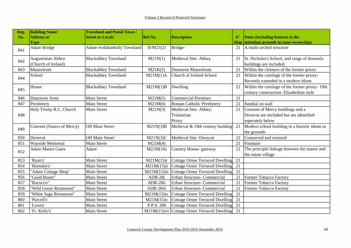
Volume 3 Record of Protected Structures
Limerick County Development Plan 2010-2016 November 2010 43
Reg.No.
Building Name/Address orType
Townland and Postal Town /Street or Locale Ref.No. Description 6"
Map Notes (including features in the attendant grounds in same ownership)
841 Adare Bridge Adare-Ardshanbally Townland H/M21(2) Bridge- 21 A multi-arched structure
842 Augustinian Abbey (Church of Ireland)
Blackabbey Townland M21N(1) Medieval Site- Abbey 21 St. Nicholas's School, and range of domestic buildings are included.
843 Mausoleum Blackabbey Townland M21K(5) Dunraven Mausoleum 21 Within the cloisters of the former priory
844School Blackabbey Townland M21M(1)A Church of Ireland School 21 Within the curtilage of the former priory-
Recently extended in a modern idiom
845 House Blackabbey Townland M21M(1)B Dwelling 21 Within the curtilage of the former priory- 19th century construction- Elizabethan style
846 Dunraven Arms Main Street M21M(5) Commercial Premises 21847 Presbetery Main Street M21M(6) Roman Catholic Presbytery 21 Sundial on wall
848Holy Trinity R.C. Church Main Street M21N(3) Medieval Site- Abbey:
Trinitarian Priory
21 Convent of Mercy buildings and a Dovecot are included but are identified seperately below
849 Convent (Sisters of Mercy) Off Main Street M21N(3)B Medieval & 19th century building 21 Modern school building in a historic idiom in the grounds
850 Dovecot Off Main Street M21N(3)C Medieval Site- Dovecot 21 Conserved and restored851 Wayside Memorial Main Street M21M(4) 21 Fountain
852 Adare Manor Gates Adare M21M(16) Country House- gateway 21 The principle linkage between the manor and the estate village
853 'Ryan's' Main Street M21M(15)i Cottage Ornee Terraced Dwelling 21854 'Hornsby's' Main Street M21M(15)ii Cottage Ornee Terraced Dwelling 21855 "Adare Cottage Shop" Main Street M21M(15)iii Cottage Ornee Terraced Dwelling 21856 "Good Room" Main Street ADR-28i Urban Structure- Commercial 21 Former Tobacco Factory857 "Rococco" Main Street ADR-28ii Urban Structure- Commercial 21 Former Tobacco Factory858 "Wild Geese Restaurant" Main Street ADR-28iii Urban Structure- Commercial 21 Former Tobacco Factory859 "White Sage Restaurant" Main Street M21M(15)iv Cottage Ornee Terraced Dwelling 21860 'Purcell's' Main Street M21M(15)v Cottage Ornee Terraced Dwelling 21861 'Lowes' Main Street P.P.S. 280 Cottage Ornee Terraced Dwelling 21862 'Fr. Kelly's' Main Street M21M(15)vii Cottage Ornee Terraced Dwelling 21

Volume 3 Record of Protected Structures
Limerick County Development Plan 2010-2016 November 2010 44
Reg.No.
Building Name/Address orType
Townland and Postal Town /Street or Locale Ref.No. Description 6"
Map Notes (including features in the attendant grounds in same ownership)
863 "Blue Door Restaurant" Main Street M21M(15)viii Cottage Ornee Terraced Dwelling 21864 'Barry's' Main Street P.P.S. 281 End of terrace thatched house 21 Consists of two conjoined buildings865 'Benson's' Main Street M21M(15)x Mid-terrace thatched house 21866 "Lucy Erridge's" Main Street P.P.S. 282 End of terrace thatched house 21867 Washpool Main Street P.P.S. 283 Park feature 21868 Culvert Main Street P.P.S. 284 Infrastructural feature 21869 'Murphy's' Main Street M21M(14) Cottage Ornee Detached Dwelling 21 Two-storey with a wet dash render
870 Courthouse Main Street/Station Road M21M(7) Urban Structure- Civic 21 Good cut-stone building of two storeys- Elizabethan idiom
871 Railway Station Station Road ADR-31 Urban Structure- Commercial 21872 Railway Bridge Station Road P.P.S. 288 Railway Infrastructure 21 Good Lattice Bridge873 Quay Station Road P.P.S. 289 Industrial Infrastructure 21 Remnants of 1st canal built in Ireland874 'Volkes' Main Street M21M(8) Commercial Premises 21 Outbuildings at rear875 Terraced House Main Street ADR-33 Commercial Premises 21876 'Garda Station' Main Street ADR-34 Urban Structure- Civic 21877 'Costello's' Main Street ADR-35 Commercial Premises 21878 The Irish Shop Main Street ADR-36 Commercial Premises 21
879
Community Hall Western end of Main Street at Junction with the Rathkeale and Blackabbey Roads
M21M(9) Urban Structure- Community 21 One of the finest Arts and Crafts stylebuildings built for community purposes in the early part of the 20th century, it was originally roofed in shingles
880 Methodist Church Blackabbey Road ADR-38 Urban Structure- Social 21882 Blackabbey Creamery Blackabbey Road P.P.S. 286 Industrial feature 21 Original buildings only883 Lodge Blackabbey Road P.P.S. 287 Demesne feature 21 In the attendant grounds of Adare Manor884 'Keane-Chambers'' Blackabbey Road (S. side) ADR-39(i) Scheme of terraced houses 21 William Clifford-Smith designed housing885 'Liston's' Rathkeale Road (W. side) ADR-39(ii) Scheme of terraced houses 21 William Clifford-Smith designed housing886 'Judge's' Rathkeale Road (W. side) ADR-39(iii) Scheme of terraced houses 21 William Clifford-Smith designed housing887 'Savage's' Rathkeale Road (W. side) ADR-39(iv) Scheme of terraced houses 21 William Clifford-Smith designed housing888 'O'Leary's' Rathkeale Road (W. side) ADR-39(v) Scheme of terraced houses 21 William Clifford-Smith designed housing889 Walsh's Rathkeale Road (W. side) ADR-39(vi) Scheme of terraced houses 21 William Clifford-Smith designed housing

Volume 3 Record of Protected Structures
Limerick County Development Plan 2010-2016 November 2010 45
Reg.No.
Building Name/Address orType
Townland and Postal Town /Street or Locale Ref.No. Description 6"
Map Notes (including features in the attendant grounds in same ownership)
890 Iona Rathkeale Road (W. side) P.P.S.290 Scheme of terraced houses 21 William Clifford-Smith designed housing891 Jones's Rathkeale Road (W. side) ADR-39(vii) Scheme of terraced houses 21 William Clifford-Smith designed housing892 Kilmurray's Rathkeale Road (W. side) M21M(10) Scheme of terraced houses 21 William Clifford-Smith designed housing893 Iverk Rathkeale Road (W. side) P.P.S. 291 Scheme of terraced houses 21 William Clifford-Smith designed housing894 'Raincín' Rathkeale Road (E. side) M21M(11) Commercial Premises 21895 'Chawke's Bar' Rathkeale Road (E. side) ADR-41 Urban Structure- Commercial 21896 Forge Rathkeale Road (E. side) M21M(13) Urban Structure- Industrial 21897 Former Manse Rathkeale Road (E. side) ADR-43(i) Urban Structure- Dwelling 21898 Outbuildings Rathkeale Road (E. side) ADR-43(ii) Complex of Outhouses 21899 'Harrington's' Back Avenue (N. side) M21M(19)i Urban Structure- Dwelling 211673 'Dunraven's' Back Avenue (N. side) M21M(19)ii Urban Structure- Dwelling 211674 'Murphy's' Back Avenue (N. side) M21M(18)i Urban Structure- Dwelling 211675 'Corrigan's Back Avenue (N. side) M21M(18)ii Urban Structure- Dwelling 211676 'O'Connor's' Back Avenue (N. side) M21M(18)iii Urban Structure- Dwelling 211677 'Hickey's' Back Avenue (N. side) M21M(18)iv Urban Structure- Dwelling 211678 'Moloney's' Back Avenue (N. side) M21M(18)v Urban Structure- Dwelling 211679 'Ruttle's' Back Avenue (N. side) M21M(18)vi Urban Structure- Dwelling 211680 Gatehouse Back Avenue (N. side) ADR-52 Country House Feature 211681 Semi-detached cottage Back Avenue (S. side) ADR-55 Urban Structure- Dwelling 211682 Semi-detached cottage No. 2, Back Avenue P.P.S. 292 Urban Structure- Dwelling1683 Semi-detached cottage Back Avenue (S. side) P.P.S. 293 Urban Structure- Dwelling 211684 Semi-detached cottage No. 4, Back Avenue ADR-30 Urban Structure- Dwelling
1685 Urban Structure- Semi-detached house
No. 5, Back Avenue P.P.S. 294 One of two conjoined asymetric buildings
21
1686 Urban Structure- Semi-detached house
No. 6, Back Avenue P.P.S. 295 One of two conjoined asymetric buildings
21
1687School Rathkeale Road (E. side) M21M(12) Urban Structure- Institutional 21 Limestone structures at the front of the plot-
Founded originally as a hospital, then run by the Christian Brothers as a school
1688 'St.Gerard's' Rathkeale Road (E. side) ADR-58 Urban Structure- Dwelling 21
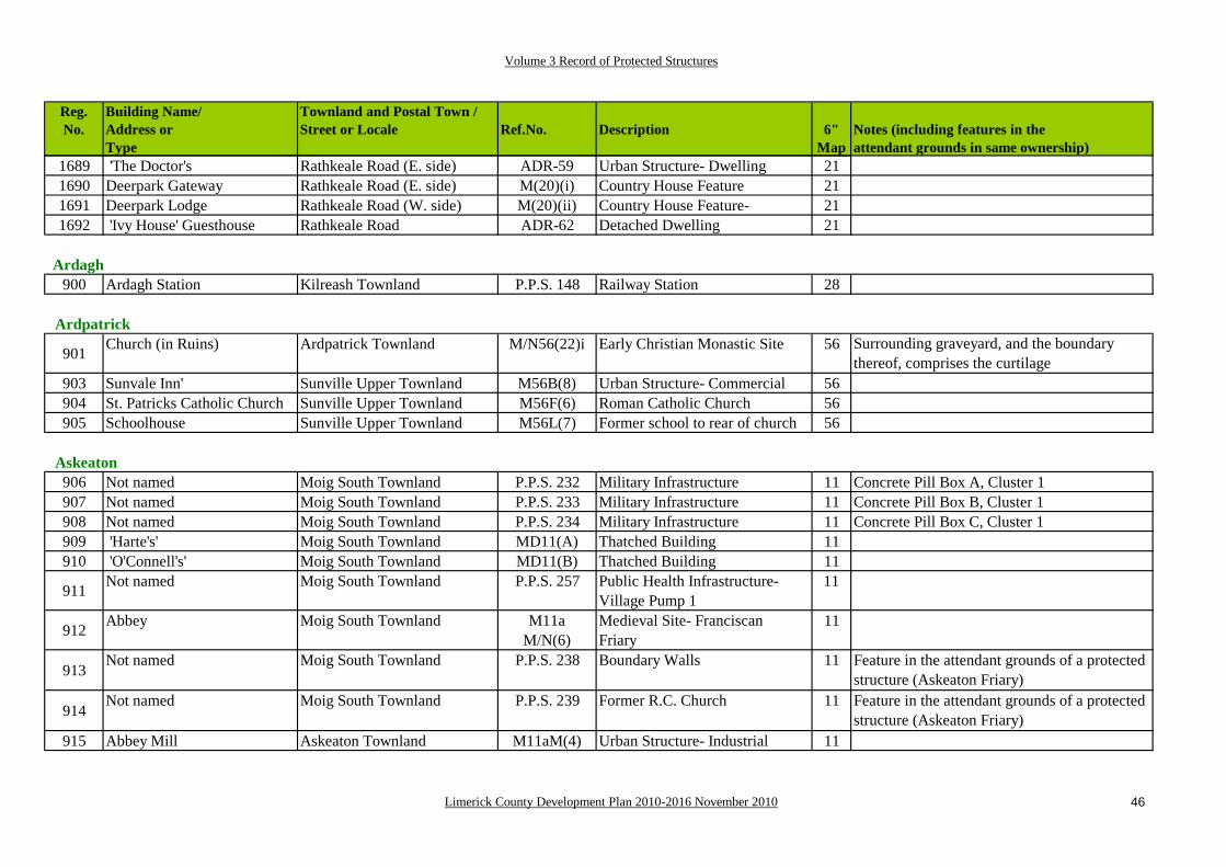
Volume 3 Record of Protected Structures
Limerick County Development Plan 2010-2016 November 2010 46
Reg.No.
Building Name/Address orType
Townland and Postal Town /Street or Locale Ref.No. Description 6"
Map Notes (including features in the attendant grounds in same ownership)
1689 'The Doctor's Rathkeale Road (E. side) ADR-59 Urban Structure- Dwelling 211690 Deerpark Gateway Rathkeale Road (E. side) M(20)(i) Country House Feature 211691 Deerpark Lodge Rathkeale Road (W. side) M(20)(ii) Country House Feature- 211692 'Ivy House' Guesthouse Rathkeale Road ADR-62 Detached Dwelling 21
Ardagh900 Ardagh Station Kilreash Townland P.P.S. 148 Railway Station 28
Ardpatrick
901 Church (in Ruins) Ardpatrick Townland M/N56(22)i Early Christian Monastic Site 56 Surrounding graveyard, and the boundary thereof, comprises the curtilage
903 Sunvale Inn' Sunville Upper Townland M56B(8) Urban Structure- Commercial 56904 St. Patricks Catholic Church Sunville Upper Townland M56F(6) Roman Catholic Church 56905 Schoolhouse Sunville Upper Townland M56L(7) Former school to rear of church 56
Askeaton906 Not named Moig South Townland P.P.S. 232 Military Infrastructure 11 Concrete Pill Box A, Cluster 1907 Not named Moig South Townland P.P.S. 233 Military Infrastructure 11 Concrete Pill Box B, Cluster 1908 Not named Moig South Townland P.P.S. 234 Military Infrastructure 11 Concrete Pill Box C, Cluster 1909 'Harte's' Moig South Townland MD11(A) Thatched Building 11910 'O'Connell's' Moig South Townland MD11(B) Thatched Building 11
911 Not named Moig South Townland P.P.S. 257 Public Health Infrastructure- Village Pump 1
11
912 Abbey Moig South Townland M11aM/N(6)
Medieval Site- FranciscanFriary
11
913Not named Moig South Townland P.P.S. 238 Boundary Walls 11 Feature in the attendant grounds of a protected
structure (Askeaton Friary)
914Not named Moig South Townland P.P.S. 239 Former R.C. Church 11 Feature in the attendant grounds of a protected
structure (Askeaton Friary)915 Abbey Mill Askeaton Townland M11aM(4) Urban Structure- Industrial 11
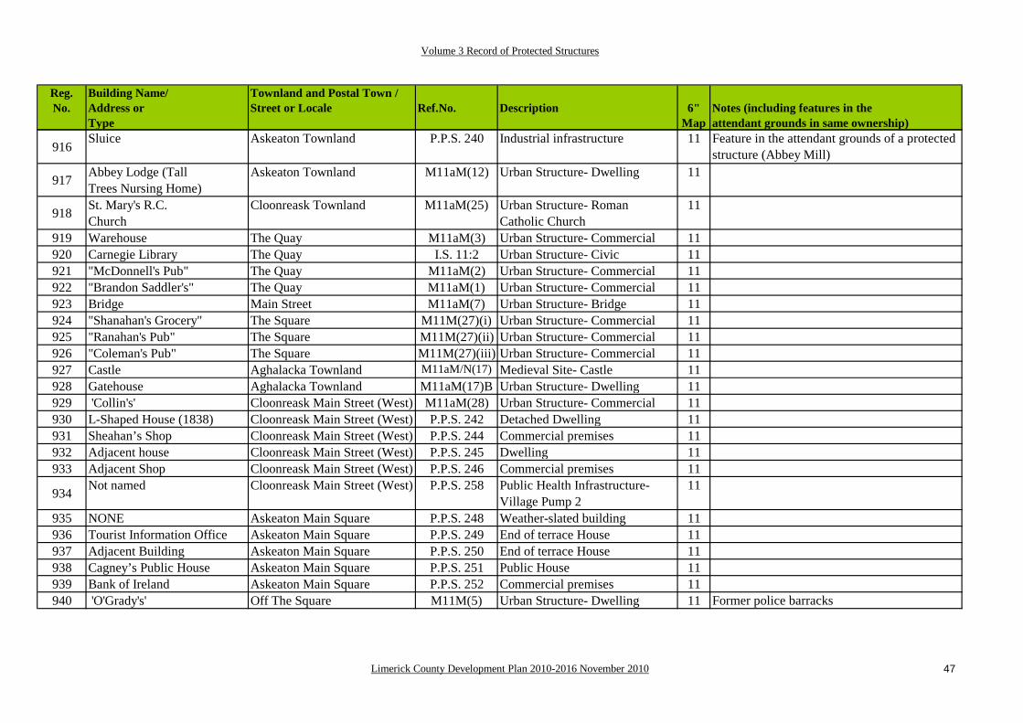
Volume 3 Record of Protected Structures
Limerick County Development Plan 2010-2016 November 2010 47
Reg.No.
Building Name/Address orType
Townland and Postal Town /Street or Locale Ref.No. Description 6"
Map Notes (including features in the attendant grounds in same ownership)
916Sluice Askeaton Townland P.P.S. 240 Industrial infrastructure 11 Feature in the attendant grounds of a protected
structure (Abbey Mill)
917 Abbey Lodge (TallTrees Nursing Home)
Askeaton Townland M11aM(12) Urban Structure- Dwelling 11
918 St. Mary's R.C.Church
Cloonreask Townland M11aM(25) Urban Structure- Roman Catholic Church
11
919 Warehouse The Quay M11aM(3) Urban Structure- Commercial 11920 Carnegie Library The Quay I.S. 11:2 Urban Structure- Civic 11921 "McDonnell's Pub" The Quay M11aM(2) Urban Structure- Commercial 11922 "Brandon Saddler's" The Quay M11aM(1) Urban Structure- Commercial 11923 Bridge Main Street M11aM(7) Urban Structure- Bridge 11924 "Shanahan's Grocery" The Square M11M(27)(i) Urban Structure- Commercial 11925 "Ranahan's Pub" The Square M11M(27)(ii) Urban Structure- Commercial 11926 "Coleman's Pub" The Square M11M(27)(iii) Urban Structure- Commercial 11927 Castle Aghalacka Townland M11aM/N(17) Medieval Site- Castle 11928 Gatehouse Aghalacka Townland M11aM(17)B Urban Structure- Dwelling 11929 'Collin's' Cloonreask Main Street (West) M11aM(28) Urban Structure- Commercial 11930 L-Shaped House (1838) Cloonreask Main Street (West) P.P.S. 242 Detached Dwelling 11931 Sheahan’s Shop Cloonreask Main Street (West) P.P.S. 244 Commercial premises 11932 Adjacent house Cloonreask Main Street (West) P.P.S. 245 Dwelling 11933 Adjacent Shop Cloonreask Main Street (West) P.P.S. 246 Commercial premises 11
934 Not named Cloonreask Main Street (West) P.P.S. 258 Public Health Infrastructure- Village Pump 2
11
935 NONE Askeaton Main Square P.P.S. 248 Weather-slated building 11936 Tourist Information Office Askeaton Main Square P.P.S. 249 End of terrace House 11937 Adjacent Building Askeaton Main Square P.P.S. 250 End of terrace House 11938 Cagney’s Public House Askeaton Main Square P.P.S. 251 Public House 11939 Bank of Ireland Askeaton Main Square P.P.S. 252 Commercial premises 11940 'O'Grady's' Off The Square M11M(5) Urban Structure- Dwelling 11 Former police barracks

Volume 3 Record of Protected Structures
Limerick County Development Plan 2010-2016 November 2010 48
Reg.No.
Building Name/Address orType
Townland and Postal Town /Street or Locale Ref.No. Description 6"
Map Notes (including features in the attendant grounds in same ownership)
941 Lime Kiln Off Church Street P.P.S. 253 Vernacular industrial structure 11 In the attendant grounds of a protectedstructure (Inchirourke [House])
942 Not named Church Street P.P.S. 259 Public Health Infrastructure- Village Pump 3
11
943 T.S. Ó Moráin’s Shop Church Street P.P.S. 254 Commercial premises 11944 Deel Pharmacy [A] Church Street P.P.S. 255 Commercial premises 11
945Church Church Street M11aM(14) Urban Structure- Church of
Ireland11 Surrounding graveyard, and the boundary
thereof, comprises the curtilage, and includes the medieval church ruins.
946 Scoil Mhuire Gateway Church Street P.P.S. 256 Educational infrastructure 11
947 Not named Church Street P.P.S. 260 Public Health Infrastructure- Village Pump 4
11
948 Not named Church Street P.P.S. 261 Milestone 11949 Glebe House Church Street B11(28) Urban Structure- Dwelling 11950 Not named Aghalacka, Askeaton P.P.S. 262 Military Infrastructure 11 Concrete Pill Box A, Cluster 2951 Not named Cloonreask, Askeaton P.P.S. 263 Military Infrastructure 11 Concrete Pill Box B, Cluster 2952 Not named Cloonreask, Askeaton P.P.S. 264 Military Infrastructure 11 Concrete Pill Box C, Cluster 2
Athea953 "C. O'Sullivan" Templeathea M34M(5) Urban Structure- Commercial 34 At the western end of the main street954 "T. O'Connor" Athea Upper M34M(8) Urban Structure- Commercial 34955 Bridge Templeathea West M34M(4) Urban Structure- Bridge 34956 "C.P. Mullane's" Gortnagross M34M(2) Urban Structure- Commercial 34957 St. Bartholomew's Athea Upper M34M(1) Roman Catholic Church 34958 NONE Athea Upper P.P.S. 166 Memorial Cross 34 Gould Memorial Cross959 'Maighgread McGrath's' Athea Upper P.P.S. 167 Urban Structure- Dwelling 34 Former Doctor's Surgery and Residence960 Carnegie Library Gortnagross [Athea] I.S. 34:2 Civic Structure- Library 34

Volume 3 Record of Protected Structures
Limerick County Development Plan 2010-2016 November 2010 49
Reg.No.
Building Name/Address orType
Townland and Postal Town /Street or Locale Ref.No. Description 6"
Map Notes (including features in the attendant grounds in same ownership)
Ballingarry961 St. Mary's Rylanes M29M(9) Roman Catholic Church 29
962 Presbetery (a.k.a.'The Turret')
Rylanes M29M(11) Urban Structure- Dwelling 29 Former Roman Catholic parochial house
963 'Echo Lodge' Knightstreet M29M(37) Urban Structure- Institutional 29 Former Convent School964 Church Cloontemple M29M(10) Church of Ireland 29 Former Church of Ireland965 'The Grove' Rylanes B29(12) Country House 29 Reputed to have been used as a Workhouse967 Castle Knightstreet M29M/N(1) Medieval Site- 'Parson's Castle' 29968 'Ahern's' Cloontemple M29M(13) Urban Structure- Commercial 29
Ballyagran969 Parochial House Ballyagran, Kilmallock B46(4) Country House- Parochial House 46970 St.Michael's R.C. Ch. Ballyagran, Kilmallock F46(3) Roman Catholic Church 46971 'Clifford's' Ballyagran, Kilmallock D46(A) Thatched Building 46 Direct Entry thatched house972 "Dore's Pub" Ballyagran, Kilmallock D46(B) Thatched Building- Public House 46973 Bennis's Shop Ballyagran P.P.S. 204 Commercial premises 46
Ballyhahill974 Bridge Finnoo H18(11) Bridge 18975 Carnegie Free Library Ballyhahill L18(15) Industrial & Institutional- Library 18
Ballylanders976 'Crowley's' Ballylanders M49M(25) Urban Structure- Commercial 49977 'Central Stores' Ballylanders M49M(26) Urban Structure- Commercial 49978 'N. Davoran' Ballylanders M49M(27) Urban Structure- Commercial 49979 'O'Grady's' Ballylanders M49M(28) Urban Structure- Commercial 49980 Church (in Ruins) Ballylanders G49(10) Church of Ireland 49

Volume 3 Record of Protected Structures
Limerick County Development Plan 2010-2016 November 2010 50
Reg.No.
Building Name/Address orType
Townland and Postal Town /Street or Locale Ref.No. Description 6"
Map Notes (including features in the attendant grounds in same ownership)
Ballyneety981 'O'Connell's' [A] Ballyneety D14(A) Thatched Building 14 Thatched Public House982 Court Ho. Glen M14AM(6) Civic Structure- Court House 14 "Sessions House"983 'O'Connell's' [B] Glen D14(J) Thatched Building 14 Public House- Thatched, Direct Entry Plan
984
Church Glen G14(7) Church of Ireland 14 Former Church of Ireland- Surrounding graveyard, and the boundary thereof, comprises the curtilage
Ballyorgan985 St. Joseph's Catholic Ch. Ballyorgan F56 (17) Roman Catholic Church 56986 Forge Ballyorgan L56(16) Industrial & Institutional 56
987 Church Ballyorgan G56(19) Church of Ireland (Kilflynn) 56 Surrounding graveyard, and the boundary thereof, comprises the curtilage
988 Rectory Coolfree B56(14) Country House 56 Former Church of Ireland residence, also known as Waterloo House.
Broadford989 St.John the Baptist's Tullaha F54(9) Roman Catholic Church 54990 Carnegie Library Tullaha I.S. 54:1 Library 54
Bruff991 Teampuillin Grave Yard Newtown BRF 16 Graveyard 32 Includes avenue and entrance stile992 O'Regan's House' Newtown BRF-17 Single storey Dwelling 32993 Cussen's House' Newtown BRF-18 Single storey Dwelling 32994 Court House Newtown M32M(50) Urban Structure- Civic 32995 'Keating's Bar' Bruff M32M(52) Urban Structure- Commercial 32996 SS.Peter and Paul's Bruff M32F(53) Roman Catholic Church 32998 "O'Connor's Pharmacy" Main Street, Bruff BRF-20A Commercial Premises 32

Volume 3 Record of Protected Structures
Limerick County Development Plan 2010-2016 November 2010 51
Reg.No.
Building Name/Address orType
Townland and Postal Town /Street or Locale Ref.No. Description 6"
Map Notes (including features in the attendant grounds in same ownership)
999 O'Connor's House' Main Street, Bruff BRF-20B End of Terrace Dwelling 321000 Bank Main Street, Bruff BRF-21 Commercial Premises 32 "Bank of Ireland"
1001 Garda Station Main Street, Bruff M32M(54) Urban Structure- Civic 32 Former R.I.C. Barracks, includesCoachhouse and outhouses to rear
1002 Mid-Terrace Dwelling Main Street, Bruff BRF-22 Former Commercial Premises 32 'O'Donovan's House'1003 Mid-Terrace Dwelling Main Street, Bruff BRF-23 Mid-Terrace Dwelling 32 'O'Donovan's House and Hall entrance
1004 Bank Main Street, Bruff BRF-24 Former A.I.B. Branch 32 Protection extends to surviving original features, facades and curtilage
1005 "Oriental Chinese Restaurant"
Main Street, Bruff BRF-25A Commercial Premises 32
1006 "Derry's Bar" Main Street, Bruff BRF-25B Commercial Premises 321007 Hourigan's' Main Street, Bruff BRF-26 Commercial Premises 321008 Quilty's' Main Street, Bruff M32M(57) Urban Structure- Commercial 321009 "Hehir Photography" Main Street, Bruff BRF-27 Commercial Premises 321010 Butler's' Main Street, Bruff M32M(58) Urban Structure- Commercial 321012 Mulcahy's Shopfront' Main Street/Crawford's Street BRF-28 Timber Shopfront 321013 "O'Donoghue's Foodstore" Main Street, Bruff BRF-29 Stucco Shopfront 321014 Collin's Premises' Main Street, Bruff BRF-30 Commercial Premises 321015 Glynn's' Main Street, Bruff BRF-31 Stucco Shopfront 321016 Kiely's Main Street, Bruff M32M(60) Urban Structure- Commercial 32 Previously M32M(59)(ii)1017 Carew's' Main Street, Bruff BRF-32 Stucco Shopfront 321018 Neilan's' Main Street, Bruff M32M(61) Urban Structure- Commercial 32 Previously M32M(59)(iii)1019 Purcell's House' Chapel Lane, Bruff BRF-33 Dwelling 321020 Prior's House' Chapel Lane, Bruff BRF-34A Dwelling- Old R.I.C. Barracks 321021 O'Connor's House' Chapel Lane, Bruff BRF-34B Dwelling- Old R.I.C. Barracks 321022 "J. Howard's" Bruff BRF-35 Dwelling / Commercial Premises 321023 Raleigh's' Bruff BRF-36 Dwelling / Commercial Premises 32
1024Church Bruff M32G(61) Church of Ireland 32 Surrounding graveyard, and the boundary
thereof, comprises the curtilage- Important Memorial in the entrance porch

Volume 3 Record of Protected Structures
Limerick County Development Plan 2010-2016 November 2010 52
Reg.No.
Building Name/Address orType
Townland and Postal Town /Street or Locale Ref.No. Description 6"
Map Notes (including features in the attendant grounds in same ownership)
1025 Mausoleum Bruff M32K(51) De Massey mausoleum 32 In grounds of the Church of Ireland1026 Grove House Bruff BRF-37A Dwelling- former doctor's house 321027 Dispy. Bruff BRF-37B Dwelling- former Dispensary 321028 Bridge Bruff M32H(64)A Urban Structure- Bridge 321029 Bridge Bruff M32H(64)B Urban Structure- Bridge 321030 Presbetery Bruff M32M(65) Urban Structure- Dwelling 321031 Hotel Ballygrennan, Bruff BRF-38A Western wing of former Hotel 32 Now a dwelling- 'Murphy's House'1032 Hotel Ballygrennan, Bruff BRF-38B Central Block of former Hotel 32 Now a dwelling- 'O'Sullivan's House'1033 St. Mary's Convent Bruff M40M(66) Urban Structure- Institutional 40
Bruree
1034 St. Munchin's R.C. Church Bruree M39M(1) Roman Catholic Church 39 Surrounding churchyard, and the boundary thereof, comprises the curtilage
1035 Health Centre Bruree M392M(7) Former Roman Catholic Church 391036 School Bruree M39M(8) Urban Structure- Civic 39 Now the De Valera Museum1037 Not named Bruree M39M(40) Urban Terraced Cottage 39 Briar Cottage1038 Creamery Bruree-Knockfenora M39M(9) Urban Structure- Industrial 39 Former Mill1039 Not named Ballynoe - Bruree M39M(4) Bridge 391040 'McMahon's' Forty Acres, Bruree D39(D) Thatched House 39 Lobby Entry thatched house
1041Church Ballynoe, Bruree M32G/M(5) Former Church of Ireland 39 Surrounding graveyard, and the boundary
thereof, comprises the curtilage, and includes the medieval church and castle ruins.
1043 Bruree Lodge Bruree P.P.S. 182 Country House 39
1044 Lodge Garroose, Bruree P.P.S. 183 Estate feature associated with Bruree House / Cuan Mhuire
39 Feature in the attendant grounds of a protected structure (Bruree House)
391 Bruree House Garroose, Bruree B39(3) Country House 39
Caherconlish1045 "Michael Lynch" Caherconlish M14M(58) Urban Structure- Commercial 14 'Micheal Lynch's Public House'

Volume 3 Record of Protected Structures
Limerick County Development Plan 2010-2016 November 2010 53
Reg.No.
Building Name/Address orType
Townland and Postal Town /Street or Locale Ref.No. Description 6"
Map Notes (including features in the attendant grounds in same ownership)
1046 Church Caherconlish M14G/M(16) Urban Structure- Old Church of Ireland
14 Surrounding graveyard, and the boundary thereof, comprises the curtilage
1047 Ch (in Ruins) Caherconlish M14G/N(16) Medieval Site- Church 141048 "O'Connell's Pharmacy" Caherconlish M14M(17) Urban Structure- Commercial 141049 NONE Caherconlish P.P.S. 86 Bungalow 14 Reroofed using natural slate in the early 2000's
1050Church Caherconlish M14G/
M(20)Urban Structure- Former Church of Ireland
14 Surrounding churchyard, and the boundary thereof, comprises the curtilage-Now in use as a dwelling
1051 Constabulary Barracks Caherconlish M14M(19)A Urban Structure- Dwelling 14 Now in use as semi-detached dwellings
Cappamore1053 Parochial House Portnard CPM-10 Dwelling1054 'Mc Carthy's' Portnard CPM-11 Dwelling 15 Former Police Barracks and Bridewell1055 'Hayes's' Turagh M15M(22) Urban Structure- Shop 151056 'T. O'Dwyer's Turagh M15M(20) Urban Structure- Commercial 151057 'Gleeson's' Turagh M(21)A Urban Structure- Commercial 151058 "Scruples Hair Salon" Turagh CPM-12 Commercial Premises 151059 Garda Siothchana Station Turagh CPM-13 Urban Structure- Civic 15 Garda Station1060 'Coffey's' Turagh CPM-14 Dwelling 151061 'Jed O'Brien's' Turagh CPM-15 Commercial Premises 151062 'Dillon's Warehouse' Turagh CPM-16 Commercial Premises 15
1063 St. Michael's R.C. Church Turagh F15(15) Catholic Church 15 Surrounding churchyard, and the boundary thereof, comprises the curtilage
1064 Convent (Sisters of Mercy) Turagh M15L/M(14)A Urban Structure- Convent 151065 Convent School Turagh M15L/M(14)B Urban Structure- School1066 Creamery Turagh CPM-8 Former Creamery & Chimney 151067 'Madden's' Turagh CPM-9A Dwelling 151068 "Madden's" Turagh CPM-9B Commercial Premises 151069 Miss Blackwell's House Turagh CPM-17 Dwelling 15

Volume 3 Record of Protected Structures
Limerick County Development Plan 2010-2016 November 2010 54
Reg.No.
Building Name/Address orType
Townland and Postal Town /Street or Locale Ref.No. Description 6"
Map Notes (including features in the attendant grounds in same ownership)
1070 'O'Donoghue's' Turagh CPM-18 Dwelling 151071 The Presbytery Turagh CPM-19 Dwelling 15 Former Church of Ireland Residence.
Castleconnell1072 Lacka House Lacka M1B(9) Country House 11073 'Edmonds' Lacka M1M(20)(i) Urban Structure - Dwelling 1 1 of 2 semi-detached structures1074 'Dundon's' Lacka M1M(20)(ii) Urban Structure - Dwelling 1 2nd of 2 semi-detached structures1075 Grange Lacka M1B(8) Country House 11076 "Glenbrook" Lacka CC-27 Urban Structure - Dwelling1079 "Meskell's" Lacka M1M(30) Urban Structure - Commercial 1 Good shopfront and untouched shop interior 1080 Rectory The Tontines (i) Cloon and Commons M1M(14)i Urban Structure - Dwelling 11081 The Tontines (ii) Cloon and Commons M (14) ii Urban Structure - Dwelling 11082 The Tontines (iii) Cloon and Commons M (14) iii Urban Structure - Dwelling 11083 The Tontines (iv) Cloon and Commons M (14) iv Urban Structure - Dwelling 1
1084 Church (in ruins) Cloon and Commons N1(13) Medieval structure- Church 1 Surrounding graveyard, and boundarythereto, comprises the curtilage
1085 Island House Cloon and Commons B(1)12 Country House 11086 'Kingston's' Cloon and Commons CC-20 Urban Structure - Dwelling 11087 'Hickey's' Cloon and Commons M1M(16)B Urban Structure- Domestic 11088 Shannon Hotel Cloon and Commons M1M(16)A Urban Structure - Commercial 1 Shannon Inn / Pub1089 Not named Cloon and Commons CC-21 Urban Structure - Dwelling 1 adjacent to Shannon Inn
1090 Cath. Ch. Coolbane M1F(15) Urban Structure - Catholic Church 1 Surrounding churchyard, and the boundary thereof, comprises the curtilage
1091 "Castle View House" Coolbane CC-18 Urban Structure- Commercial 11092 "Worrall's Inn" Cloon and Commons CC-22 Urban Structure- Commercial 11093 Community Hall Coolbane CC-19 Urban Structure- Civic 11094 Castleconnell School Coolbane M1L(23) Urban Structure - Institutional 11095 Station Coolreiry M1L(17) Industrial- Railway Station 11096 "Guerin's Bar" Coolbane CC-23 Urban Structure- Commercial 1
Volume 3 Record of Protected Structures
Limerick County Development Plan 2010-2016 November 2010 55
Reg.No.
Building Name/Address orType
Townland and Postal Town /Street or Locale Ref.No. Description 6"
Map Notes (including features in the attendant grounds in same ownership)
1097 Not named 14 Castle Street P.P.S. 384 Mid-terrace single storey House 1 Now used, with the adjacent building as a community centre
1098 Not named 15 Castle Street P.P.S. 385 Mid-terrace single storey House 1 Now used, with the adjacent building as a community centre
1099 Castle Connell (in Ruins) Coolbane N1(19) Medieval Site- Castle 11100 Shanacloon House Coolbane CC-25 Country House 11101 Shannon View Stradbally North CC-15 Country House 1 Previously a Presbytery1102 Stradbally School Stradbally North M1L(18) Urban Structure - Institutional 1
1103 Woodlands - Castle Oaks Hotel
Stradbally North M1B(27) Country House 1
1104 Courthouse Stradbally North CC-28 Urban Structure- Civic 1 Former Courthouse- internal features survive1105 Rock Lodge Coolbane CC13 Country House 1
1106 Church of Ireland Stradbally North G1(25) Church of Ireland 1 Surrounding graveyard, and boundarythereto, comprises the curtilage
1107 Lodge Stradbally North P.P.S. 386 Church of Ireland Gate Lodge 1 Designed by William Clifford Smith1108 Graveyard Stradbally North G1(25)A Graveyard 1 Interesting mausolea and gravemarkers
1109Not named Stradbally North P.P.S. 387 Mausoleum 1 General Sir Richard Bourke, K.C.B., early
Governor General of New South Wales, founder of Melbourne
1110 Not named Stradbally North P.P.S. 388 Tomb 1 Early use of concrete and cast iron
Crecora
1111 SS.Peter and Paul'sCatholic Church
Skehanagh M22F(4) Roman Catholic Church Surrounding churchyard, and the boundary thereof, comprises the curtilage
1112 School Ballyveelish M22L(5) Industrial and Institutional- School
Former Schoolhouse
Croagh1113 "O'Carroll's" Ballycannon M20M(34) Urban Structure- Commercial Public House
Volume 3 Record of Protected Structures
Limerick County Development Plan 2010-2016 November 2010 56
Reg.No.
Building Name/Address orType
Townland and Postal Town /Street or Locale Ref.No. Description 6"
Map Notes (including features in the attendant grounds in same ownership)
1114Church (in Ruins) Adamswood M20M/N(38) Urban Structure- Medieval Site
&
20 Surrounding graveyard, and boundarythereto, comprises the curtilage
1115 Castle (in Ruins) Adamswood M/N(45) Urban Structure- Medieval Site 201116 Mausoleum Adamswood K/M20(36) Fitzgerald Mausoleum 20 Fitzgerald Mausoleum1117 Sch. Adamswood M20M(35) Urban Structure- Institutional 20 Now a Community Hall
1118 St. John the Baptist's R.C.Church
Ballycannon M20M(37) Roman Catholic Church 20 Surrounding churchyard, and the boundary thereof, comprises the curtilage
1119 'O'Connor's' Adamswood, Croagh D(20)C Thatched Building 20 Direct Entry thatched house
Croom
1120 Hospital Skagh L30(27) Institutional & Industrial-Former Workhouse
30
1121 School Skagh M30(25) Urban Structure- Institutional 30
1122 Railway Station Tooreen M30(26) Urban Structure- Industrial 30 Stationhouse destroyed by fire, good Goods Shed and other infrastructure features survive
1123 "Croom Bar" Main Street (West side) M30M(55) Urban Structure- Commercial 301124 "Hogan's" Main Street (West side) M30M(54) Urban Structure- Commercial 301125 "Shanahan's" Main Street (East side) CRM-21 Urban Structure- Commercial 301126 "Downey's" Main Street (East side) CRM-22 Urban Structure- Commercial 301127 Croom House Croom townland M30M(18) Country House 30 Includes gatelodge and gateways.1128 Bank High Street (South side) CRM-23 Urban Structure- Commercial 30 Allied Irish Bank1129 "R. Cregg's Shop" Bridge Street (North side) CRM-24 Urban Structure- Commercial 301130 'Sean de Cregg's' Bridge Street (North side) CRM-25 Urban Structure- Commercial 301131 'Tangney's House' Bridge Street (North side) CRM-26 Urban Structure- Commercial 301132 "J. Moroney's" Bridge Street (North side) M30M(53) Urban Structure- Commercial 301133 Not named Bridge Street M30(52) Urban Structure- Bridge 30
1134 Church Croom townland M30M(19) Church of Ireland 30 Surrounding graveyard, and boundarythereto, comprises the curtilage
1135 Mausoleum Croom townland K/M30(17)A Mausoleum 30 In the grounds of the Church of Ireland1136 Mausoleum Croom townland K/M30(17)B Mausoleum 30 In the grounds of the Church of Ireland

Volume 3 Record of Protected Structures
Limerick County Development Plan 2010-2016 November 2010 57
Reg.No.
Building Name/Address orType
Townland and Postal Town /Street or Locale Ref.No. Description 6"
Map Notes (including features in the attendant grounds in same ownership)
1137 Mill Croom townland M30M(20) Urban Structure- Mill (derelict) 30 Mill1138 Mill Croom townland M30M(21) Urban Structure-Commercial 30 Mill Granary (Tourist facility & Offices)
1139 St. Mary's R.C. Church Croom townland M (16) Roman Catholic Church 30 Surrounding churchyard, and the boundary thereof, comprises the curtilage
1140 Not named Croom townland M (17)(i) Urban Structure- Dwelling 30 Former Estate House- 2 storey1141 Not named Croom townland M (17)(ii) Urban Structure- Dwelling 30 Former Estate House- 2 storey1142 Not named Croom townland M (17)(iii) Urban Structure- Dwelling 30 Former Estate House- single storey1143 Not named Croom townland M (17)(iv) Urban Structure- Dwelling 30 Former Estate House- single storey1144 Not named Croom townland M (17)(v) Urban Structure- Dwelling 30 Former Estate House- single storey
1145 Croom Castle Croom townland M30M(23) Medieval Site and Country House 30 A complex site with evidence for multi-period usage with consequent alterations.
Doon
1146 St. Fintan's Monastery Doon South P.P.S. 89 Former Christian Brothers facility
16 Protection extends to 19th centuryfeatures in grounds of the church
1147 Parochial House Doon South P.P.S. 90 R.C. Presbytery 161148 Moore's Pub' Doon South P.P.S. 91 Public House 16
1149 "A.I.B." Doon South P.P.S. 92 Commercial premises 16 Former Branch of the Munster and Leinster Bank
1150 Hotel Doon M16M(11) Urban Structure- Commercial 16 "Patrick Ryan"1151 "O'Dwyer's" Doon M16M(12) Urban Structure- Commercial 161152 "Hibernian House" Doon M16M(13) Urban Structure- Commercial 161153 "N. Rainsfort" Doon M16M(14) Urban Structure- Commercial 161154 Garda Station Kilmoylan Lower P.P.S. 93 Former R.I.C. Barracks 16 Barracks is mothballed
1155 Christ Church Cooga Upper G16(1) Former Church of Ireland 16 Surrounding graveyard, and boundarythereto, comprises the curtilage
Dromcolliher1156 Bank The Square, Dromcolliher P.P.S. 218 Allied Irish Bank Branch 54 Terraced premises in cut stone1157 "Aherne's Bar" The Square, Dromcolliher M(E) /M(54) Urban Structure- Public House 54

Volume 3 Record of Protected Structures
Limerick County Development Plan 2010-2016 November 2010 58
Reg.No.
Building Name/Address orType
Townland and Postal Town /Street or Locale Ref.No. Description 6"
Map Notes (including features in the attendant grounds in same ownership)
1161 NONE Carroward West, Dromcolliher
P.P.S. 221 Library 54 Built as a memorial to the victims of the Dromcolliher cinema fire of 1925
1162 Woodfield House Woodfield, Dromcolliher P.P.S. 215 Country House and Gate Lodge 54 Former Dispensary Doctor's Residence on the western outskirts of the town
1163 Not named Woodfield, Dromcolliher P.P.S. 216 Civic Structure 54 Garda Station
1164 Not named Carroward West, Dromcolliher
P.P.S. 222 Former V.E.C. School 54 Organic College
1165 Creamery Carroward East M54M(1) Urban Structure- Civic 54
1166 Church Carroward West M54M(5) Roman Catholic Church 54 Surrounding churchyard, and the boundary thereof, comprises the curtilage
1167 Church (in ruins) Carroward West M54M/N(4) Medieval Site 54 Surrounding graveyard, and boundarythereto, comprises the curtilage
1168 Courthouse Carroward West M54M(3) Urban Structure- Civic 54
Elton
1169 " Creeds " Elton Urban Structure- Commercial 40 A particularly good late 19th century building in a prominent location in the village.
Fedamore1170 Fedamore House Fedamore Td., Fedamore B22(31) Country House 22
1171 St. John the Baptist's Ballyea, Fedamore F22(24) Roman Catholic Church22 Surrounding churchyard, and the boundary
thereof, comprises the curtilage1172 "The Thatch Bar" Castlequarter D22(A) Thatched Building- Public House 22 Thatched Public House- Lobby Entry Plan
Feenagh1173 'Irwin's' Feenagh M45(22) Urban Structure - Dwelling 45
1174 'Gayer's' Feenagh B45(23)/D45(D)
Urban Structure - Dwelling- Thatched House
45Lobby Entry thatched house
Volume 3 Record of Protected Structures
Limerick County Development Plan 2010-2016 November 2010 59
Reg.No.
Building Name/Address orType
Townland and Postal Town /Street or Locale Ref.No. Description 6"
Map Notes (including features in the attendant grounds in same ownership)
Foynes1176 Monument Leahys M10(12) Urban Structure- Civic 10 High Cross- Spring-Rice Memorial 1177 Terminus Corgrig M10L(11) Urban Structure- Industrial 10 Railway Station1178 Not named Corgrig M (2)(i) Urban Structure- Commercial 10 Post Office1179 Not named Corgrig M (2)(ii) Urban Structure- Commercial 10 Amalgamated with adjacent building1180 Not named Corgrig M (2)(iii) Urban Structure- Commercial 10 Amalgamated with adjacent building1181 Not named Corgrig M (2)(iv) Urban Structure- Commercial 10 Dental Clinic1182 Aviation Museum Corgrig P.P.S. 36 Aviation infrastructure 101183 Memorial Cross Corgrig P.P.S. 46 Wayside Memorial 101184 Former Hotel Ballynacragga North P.P.S. 35 Aviation infrastructure 101185 School Ballynacragga North P.P.S. 34 Victorian period schoolhouse 101186 Shannon Inn Corgrig P.P.S. 37 Hotel 101187 O'Connor's' Corgrig P.P.S. 38 Shop1188 'Kelly's' [Costcutter's] Corgrig M10M(9)(i) Urban Structure- Commercial 101189 St. Senan's R.C. Church Corgrig M10F(1) Roman Catholic Church 101190 'Nolan's' Corgrig M10M (9)(ii) Urban Structure- Commercial 10 Linked to adjacent structure1191 'Nolan's' Corgrig P.P.S. 39 Former Shop 10 Adjacent to the building above1192 " M. Fitzgerald " Corgrig M10M(8) Public House- The Kerry Bar 101193 Barracks Corgrig M10M(7) Urban Structure- Civic 10 Former Garda Station1194 NONE Corgrig P.P.S. 40 End of terrace House 101195 NONE Corgrig P.P.S. 41 Mid-terrace House 101196 NONE Corgrig P.P.S. 42 End of terrace House 101198 O'Connor's Corgrig P.P.S. 47 Former Shop 101199 Elekiel's Corgrig P.P.S. 48 Former Shop/Restaraunt 101200 'Nestor's' Corgrig P.P.S. 49 End of terrace House 101201 'Carney's' Corgrig P.P.S. 50 Mid-terrace House 101202 Bank Corgrig M10L(6) Urban Structure- Commercial 10 Former Bank of Ireland premises1203 Pharmacy Corgrig P.P.S. 51 Mid-terrace House 101204 NONE Corgrig P.P.S. 52 End of terrace House 10
Volume 3 Record of Protected Structures
Limerick County Development Plan 2010-2016 November 2010 60
Reg.No.
Building Name/Address orType
Townland and Postal Town /Street or Locale Ref.No. Description 6"
Map Notes (including features in the attendant grounds in same ownership)
1206 12 Woodview Terrace Corgrig P.P.S. 56 End of terrace House 101207 NONE Corgrig P.P.S. 44 Detached Dwelling 101208 NONE Corgrig P.P.S. 45 Detached Dwelling 101209 NONE Corgrig P.P.S. 55 Detached Dwelling 101210 'Kelly's' Corgrig M10M(4)i Terraced Estate House 10 Creeven Terrace A1211 Corgrig M10M(4)ii Terraced Estate House 10 Creeven Terrace B1212 'FitzSimmons's' Corgrig M10M(4)iii Terraced Estate House 10 Creeven Terrace C1213 'Parry's' Corgrig M10M(4)iv Terraced Estate House 10 Creeven Terrace D1214 'MacSiacuis' Corgrig M10M(4)v Terraced Estate House 10 Creeven Terrace E1215 'Enright's' Corgrig M10M(4)vi Terraced Estate House 10 Creeven Terrace F1216 Corgig Castle Corgrig N10(15) Medieval Site 101217 Parsonage Ballynacragga M10M(14) Church of Ireland Presbytery 101218 Corgrig Lodge Corgrig P.P.S. 57 Detached Dwelling 10 Ancillary features in grounds1219 Church of Ireland Corgrig P.P.S. 58 Church of Ireland 10
Galbally1220 " W. Wallace " Killinane M49M(18) Urban Structure - Commercial 491221 " O'Neill " Killinane M49M(15)5 Urban Structure - Commercial 491222 " Hedigan " Killinane M49M(33) Urban Structure - Commercial 491223 " Scanlon " Killinane M49M(36) Urban Structure - Commercial 491224 " P. Kelly " Killinane M49M(32) Urban Structure - Commercial 49
1225 Galbally Church Galbally N49(16) Medieval Site 49 Surrounding graveyard, and boundarythereto, comprises the curtilage
1227 Not named Killinane-Galbally M49M(24) Urban Structure- Civic 49 Boundary walls of stream course1228 " Ryan " Killinane M49M(39) Urban Structure - Commercial 491229 Sch. Killinane M49M(17) Urban Structure- Institutional 49 Now used as a Community Hall1230 Bridge Galbally-Park M49H(13) Bridge- 3 Arches 49

Volume 3 Record of Protected Structures
Limerick County Development Plan 2010-2016 November 2010 61
Reg.No.
Building Name/Address orType
Townland and Postal Town /Street or Locale Ref.No. Description 6"
Map Notes (including features in the attendant grounds in same ownership)
Glin
1231 NONE Ballynamuddagh /Glin Demesne
P.P.S. 115 Sea Wall 17 Coastal infrastructure
1232Glin Castle Glin Demesne B17(11) Country House 17 Includes: Walled Garden, Gate Lodges, Estate
Cottages, Lime Kiln, Demesne Walls- see below
1233 Lodges Glin Demesne P.P.S. 109 Gate Lodge 17 Feature in grounds of protected structure
1234 Lodge Glin Demesne P.P.S. 110 Gate Lodge 17 Feature in grounds of protected structure
1235 NONE Glin Demesne P.P.S. 112 Gate Lodge 17 Feature in grounds of protected structure
1236 NONE Glin Demesne P.P.S. 113 Demesne feature [Glin Castle]- Demesne Wall, includes Ha-Ha
17 Feature in grounds of protected structure
1237 NONE Glin Demesne P.P.S. 114 Hermitage- Demesne feature 17 Feature in grounds of protected structure1238 Hamilton Tower Killacolla P.P.S. 97 Estate Folly 17 In the attendant lands of the Glin Estate1239 Hamilton Villa Ballygiltenan North P.P.S. 98 R.C. Presbytery 171243 The Mall Killacolla P.P.S. 106 Mid-terrace House 171244 Main Street Killacolla P.P.S. 108 Single storey dwelling 171245 Castle Killacolla (Barker) M17N(15) Medieval Site - Tower house ruin 17 Includes Bawn remains1246 Hotel Main Street (West side) M17M(3)i Urban Structure - Commercial 171247 " Conway " Main Street (West side) M17M(3)ii Urban Structure - Commercial 171248 " Dunne " Main Street/Creagh Street M17M(7) Urban Structure - Commercial 171249 Courthouse Main Street (West side) M17L(8) Urban Structure - Civic 171250 " McNamara " Main Street (East side) M17M(6) Urban Structure - Commercial 171251 " Danaher " Main Street (West side) M17M(5) Urban Structure - Commercial 171252 " Culhane " Main Street (West side) M17M(4) Urban Structure - Commercial 171253 " O'Shaughnessy " Main Street- Church Street M17M(2) Urban Structure - Commercial 17
1254 R.C. Church Church Street M17F(9) Roman Catholic Church 17 Surrounding churchyard, and the boundary thereof, comprises the curtilage

Volume 3 Record of Protected Structures
Limerick County Development Plan 2010-2016 November 2010 62
Reg.No.
Building Name/Address orType
Townland and Postal Town /Street or Locale Ref.No. Description 6"
Map Notes (including features in the attendant grounds in same ownership)
1255 St. Paul's Church Church Street M17G(10) Former Church of Ireland 17 Surrounding graveyard, and the boundary thereof, comprises the curtilage
1256 " Geoghegan " Lower Mall (West side) M17M(1) Urban Structure - Commercial 17
Herbertstown
1257 'O'Dwyer's' [A] Herbertstown M32M(68)i
Urban Structure - Dwelling 32 Northern wing of conjoined structures, aligned east-west.
1258 'O'Dwyer's' [B] Herbertstown M32M(68)ii
Urban Structure- Dwelling 32 Western wing of conjoined structures, aligned north-south.
1259 Sacred Heart Church Herbertstown M32F(30) Urban Structure - Catholic Church 32
Hospital1260 'Reale's House' Castle Farm HPL-16 Rural Structure- Dwelling 321261 'Ryan's House' Castle Farm HPL-17 Rural Structure- Dwelling 321262 Water Tower Castlefarm M32aM(13) Urban Structure- Infrastructure 321263 Parochial House Castle Farm HPL-18 Urban Structure - Dwelling 321264 Kenmare Castle Barrysfarm M32aM(14) Country House 321265 Not named Barrysfarm HPL-15 Urban Structure - Dwelling 32 Kenmare Castle Gateway
1267 Church (in Ruins) Barrysfarm M32aN(11) Medieval Site 32 Remains of a Knights HospitallerFoundation
1268 "Garda Station" Lower Main Street HPL-19 Urban Structure - Institutional 321269 Arcaded Market House Lower Main Street M32aM(3) Urban Structure - Commercial 321270 "Community & Enterprise" Lower Main Street HPL-20 Urban Structure - Commercial 321271 "D. O'Carroll" Lower Main Street HPL-21 Urban Structure - Commercial 321272 "Drapery/Grocers/Outfitters" Lower Main Street M32M(2) Urban Structure - Commercial 321273 "O'Byrne Bros." Lower Main Street HPL-22 Urban Structure - Commercial 321274 Former shop with surviving sh Main Street HPL-23 Urban Structure - Commercial 321275 "The Arcade" Main Street, Hospital M32a(72) Urban Structure - Commercial 321277 " O'Leary " Main Street, Hospital M32a(73) Urban Structure - Commercial 321278 " English " Main Street, Hospital M32a(71) Urban Structure - Commercial 32

Volume 3 Record of Protected Structures
Limerick County Development Plan 2010-2016 November 2010 63
Reg.No.
Building Name/Address orType
Townland and Postal Town /Street or Locale Ref.No. Description 6"
Map Notes (including features in the attendant grounds in same ownership)
1279 "Gannon Pharmacy" Main Street, Hospital HPL-24 Urban Structure - Commercial 401280 " McElligot " II Main Street, Hospital HPL-25 Urban Structure - Commercial 401281 "Jones" Main Street, Hospital HPL-26 Urban Structure - Commercial 401282 "J. O'Sullivan" Main Street, Hospital HPL-27 Urban Structure - Commercial 401283 "John J.M. Power & Co" Main Street, Hospital HPL-28 Urban Structure - Commercial 401284 " Woods " Main Street, Hospital M40(70) Urban Structure - Commercial 401285 Bank Main Street, Hospital HPL-29 Urban Structure - Commercial 40 A.I.B. Premises1286 " McElligot " I Main Street, Hospital M40(69)A Urban Structure - Commercial 321287 Céardscoil- former V.E.C. Knocklong Road L (78) Urban Structure - Institutional 401288 Not marked Knocklong Road HPL-30 Urban Structure- Garage 401289 "Lynch Monument" Knocklong Road HPL-31 Wayside Memorial 401290 Gotoon House Knocklong Road HPL-32 Urban Structure - Institutional 40
Kilbehenny1291 St. Joseph's Catholic Church Churchquarter M60M(2) Roman Catholic Church 60
Kilfinnane156 'McCarthy's' Ballyroe Lower D48(F) Thatched House 481293 Kilfinnane Rectory Kilfinnane KFN-21 Dwelling 48 Former Church of Ireland Rectory1294 National School Kilfinnane M48M(2) Urban Structure - Institutional 48 Former Boys' School1295 Convent Kilfinnane M48M(14) Urban Structure - Institutional 48
1296 St. Andrew's Catholic Ch. Kilfinnane M48M(12) Roman Catholic Church 48 Surrounding churchyard, and the boundary thereof, comprises the curtilage
1297 Not named Kilfinnane M48M(15) Dwelling 48 Presbytery
1299 Not named Kilfinnane M48M(18)B Churchyard 48 Church yard & boundaries thereof, ruined church & ruined tower opposite
1300 Not named Church Road (Chapel Lane) KFN-22 Former V.E.C. Establishment 48 V.E.C. Outdoor Education Centre
1301 School Church Road (Chapel Lane) M48M(13) Urban Structure - Institutional 48 Former Girls' School now serving as theNational School for the area
1302 Spring Lodge Kilfinnane M48M(7) Urban Structure - Dwelling 48

Volume 3 Record of Protected Structures
Limerick County Development Plan 2010-2016 November 2010 64
Reg.No.
Building Name/Address orType
Townland and Postal Town /Street or Locale Ref.No. Description 6"
Map Notes (including features in the attendant grounds in same ownership)
1303 'Fitzell's Shop' Main Street KFN-24 End of terrace shop / dwelling 481304 "McCarthy's Pub" Main Street KFN-25 End of terrace public house 481305 'Morrissey's' Main Street KFN-26 End of terrace double house 481307 "O'Connell's Hairdresser's" Main Street KFN-28 Mid-terrace Commercial Premises 481308 "Fitzgerald's Shop" Main Street KFN-29 Mid-terrace Commercial Premises 481309 Our Lady of Lourdes Grotto Laght Street KFN-27 Grotto1310 "Molly's Restaurant" High Street KFN-30 Mid-terrace Commercial Premises 481311 'Duff's' High Street KFN-31 Mid-terrace Commercial Premises 481312 " Healy " High Street and Main Street M48(45) Urban Structure - Commercial 481313 " P.D. Healy " Main Street M48(44) Urban Structure - Commercial 481314 " Doherty's Hotel " The Square M48M(41) Urban Structure - Commercial 481315 "Doctor's Surgery" The Square M48M(43) Urban Structure 481316 " McCarthys Hardware " The Square M48(42) Urban Structure - Commercial 481317 Former A.I.B. Branch The Square KFN-32 Urban Structure- Commercial 481318 "Ó Ceallachair" The Square M48M(50) Urban Structure- Commercial 481319 " Crowleys " The Square M48(40) Urban Structure - Commercial 481322 'Hosford's A' The Square KFN-33 Mid-terrace Commercial Premises 481323 'Hosford's B' The Square KFN-34 Mid-terrace Commercial Premises 481324 'Market House' The Square M48(48) Urban Structure - Commercial 481325 'Bowle's' West End KFN-35 Terraced Cottage 481326 "D.J.Hayes's" West End KFN-36 Mid-terrace Dwelling 481327 'Lohan's' West End KFN-37 Former Commercial Premises 481328 The Priory Ardpatrick Road KFN-38 Dwelling 481329 'Cleary's' Ardpatrick Road KFN-39 Dwelling 481330 "The Old Bridewell" Ardpatrick Road M48(10) Urban Structure - Dwelling 48 Former Jail1331 Kilfinnane Mote Kilfinnane N56(39) Medieval Site 561333 'Murphy's' Ardpatrick Road KFN-40 Dwelling 561334 Glendove House Ardpatrick Road KFN-41 Dwelling 56 Former Dispensary Doctor's House1335 Ashbrook Ardpatrick Road M56(28) Urban Structure - Dwelling 561336 Spahill House Kilfinnane KFN-42 Dwelling / Country House 56
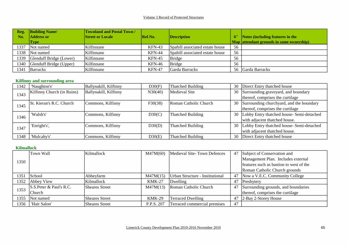
Volume 3 Record of Protected Structures
Limerick County Development Plan 2010-2016 November 2010 65
Reg.No.
Building Name/Address orType
Townland and Postal Town /Street or Locale Ref.No. Description 6"
Map Notes (including features in the attendant grounds in same ownership)
1337 Not named Kilfinnane KFN-43 Spahill associated estate house 561338 Not named Kilfinnane KFN-44 Spahill associated estate house 561339 Glenduff Bridge (Lower) Kilfinnane KFN-45 Bridge 561340 Glenduff Bridge (Upper) Kilfinnane KFN-46 Bridge 561341 Barracks Kilfinnane KFN-47 Garda Barracks 56 Garda Barracks
Kilfinny and surrounding area 1342 'Naughton's' Ballynakill, Kilfinny D30(F) Thatched Building 30 Direct Entry thatched house
1343 Kilfinny Church (in Ruins) Ballynakill, Kilfinny N30(40) Medieval Site 30 Surrounding graveyard, and boundarythereof, comprises the curtilage
1345 St. Kieran's R.C. Church Commons, Kilfinny F30(38) Roman Catholic Church 30 Surrounding churchyard, and the boundary thereof, comprises the curtilage
1346 'Walsh's' Commons, Kilfinny D30(C) Thatched Building 30 Lobby Entry thatched house- Semi-detachedwith adjacent thatched house.
1347 'Enright's', Commons, Kilfinny D30(D) Thatched Building 30 Lobby Entry thatched house- Semi-detachedwith adjacent thatched house.
1348 'Mulcahy's' Commons, Kilfinny D30(E) Thatched Building 30 Direct Entry thatched house
Kilmallock
1350
Town Wall Kilmallock M47M(60) Medieval Site- Town Defences 47 Subject of Conservation andManagement Plan. Includes externalfeatures such as bastion to west of the Roman Catholic Church grounds
1351 School Abbeyfarm M47M(15) Urban Structure - Institutional 47 Now a V.E.C. Community College1352 Abbey View Kilmallock KMK-27 Dwelling 47 Presbytery
1353 S.S.Peter & Paul's R.C. Church
Sheares Street M47M(13) Roman Catholic Church 47 Surrounding grounds, and boundariesthereof, comprises the curtilage
1355 Not named Sheares Street KMK-29 Terraced Dwelling 47 2-Bay 2-Storey House1356 'Hair Salon' Sheares Street P.P.S. 207 Terraced commercial premises 47

Volume 3 Record of Protected Structures
Limerick County Development Plan 2010-2016 November 2010 66
Reg.No.
Building Name/Address orType
Townland and Postal Town /Street or Locale Ref.No. Description 6"
Map Notes (including features in the attendant grounds in same ownership)
1357 Abbey (Dominican) (in Ruins)
Abbeyfarm M47M(25) Urban Structure - Friary 47 Surrounding grounds, and the boundary thereof, comprises the curtilage
1358 Not named Sheares Street KMK-30 Terraced Dwelling 47 2-Bay 2-Storey House1359 Not named Sheares Street KMK-31 Terraced Dwelling 47 2-Bay 2-Storey House
1360 Museum Chapel Lane KMK-33 Dwelling 47 3-Bay 2-Storey House- now in use asthe local Museum
1361 Council Offices (Temporary) Sheares Street KMK-32 Terraced Dwelling 47 3-Bay 2-Storey House
1362 King's Castle (in Ruins) Junction of Sheares and Sarsfield Streets
M47M(30) Medieval Structure:- Town Defences- Gate
47
1363 Not named Sarsfield Street M47M(36) Medieval Site- Merchant's House 47 Originally 3 storey but now reduced inheight
1364 Round Tower / Church / Church (in Ruins)
Orr Street M47M(38) Medieval Site- Collegiate Church 47 Surrounding graveyard, and boundarythereof, comprises the curtilage
1365 Not named Sarsfield Street M47M(32)A Urban Structure - Commercial 47 Bird and Foliage motif in Stucco at1366 Not named Sarsfield Street M47M(32)B Urban Structure- Commercial 47 junction between these buildings
1367 M.J. Feore Sarsfield Street KMK-34 Commercial Premises 47 Vitrolite Shopfront in black- a very rare survival.
1368 Not named Sarsfield Street M47M(28)A Urban Structure - Commercial 47 Cinema- now the Friar's Gate Theatre
1369 Not named Sarsfield Street M47M(28)B "The Sarsfield House" 47 17th Century House remains in the sidewalls of the plot
1370 Not named Sarsfield Street KMK-35 Dwelling 47 Stucco fronted House
1371 Not named Sarsfield Street KMK-36 Commercial Premises 47 Pedimented fronted Commercial Building- former Garage
1372 Not named Sarsfield Street KMK-37 Commercial Premises 47 "Abbey Launderette & Dry Cleaners"1373 Bridge Wolfe Tone Street M47M/H(39) Urban Structure- Bridge 471374 Not named Wolfe Tone Street M47M(39)v Urban Structure - Dwelling 47 Terraced Cottage1375 Not named Wolfe Tone Street M47M(39)iv Urban Structure - Dwelling 47 Terraced Cottage1376 Not named Wolfe Tone Street M47M(39)iii Urban Structure - Dwelling 47 Terraced Cottage1377 Not named Wolfe Tone Street M47M(39)ii Urban Structure - Dwelling 47 Terraced Cottage1378 Not named Wolfe Tone Street M47M(39)i Urban Structure - Dwelling 47 Terraced Cottage

Volume 3 Record of Protected Structures
Limerick County Development Plan 2010-2016 November 2010 67
Reg.No.
Building Name/Address orType
Townland and Postal Town /Street or Locale Ref.No. Description 6"
Map Notes (including features in the attendant grounds in same ownership)
1379Church Deebert M47M(22) Church of Ireland 47 Curtilage comprises of the land to the
front, sides, and rear, including the graveyard and the boundaries.
1380 Coote Memorial Hall Deebert KMK-43 Institutional Premises 47 Served as F.C.A. Company H.Q.1381 Deebert Ho. Deebert M47M(20) Urban Structure - Dwelling 47 Operated as a Guesthouse
1382 Creamery Deebert M47M(34) Urban Structure - Industrial 47 Site of Mill Complex- now location for Hotel
1383 Not named Wolfe Tone Street KMK-39 Institutional Premises 47 3-Bay 2-Storey House1385 Not named Wolfe Tone Street KMK-41 Terraced Dwelling 47 2-Bay 2-Storey House
1387 Not named Sarsfield Street M47M(43) Urban Structure - Commercial 47 "Giftline", 2-Bay 3-Storey building. Remains of medieval town house on the rear of the plot
1388 Not named Sarsfield Street M47M(45) Urban Structure - Commercial 47 'Miss Darcy's'- now a Turf Accountant's office
1389 Not named Sarsfield Street M47M(42) Urban Structure- Commercial 47 "O'Sullivan"- Butcher's stall- Goodtiled façade and fascia.
1390 Not named Wolfe Tone Street - Lord Edward Street
M47M(29) Urban Structure- Commercial 47 'Fraser's'- Double façaded 3-Storeybuilding
1391 Not named Sarsfield Street KMK-38 Commercial Premises 47 'McAuliffe's Public House'- now Lynch's1392 Not named Lord Edward Street KMK-44 Commercial Premises 47 "Lee's Law Offices"
1393 Not named Lord Edward Street M47M(26) Urban Structure- Commercial 47 Branch of the Munster and Leinster Bank, now Allied Irish Banks branch
1394 Not named Lord Edward Street KMK(46) Commercial Premises 47 "FDC Offices"1395 Not named Lord Edward Street M47M(40) Urban Structure- Commercial 47 "Ó Cearbhaill"
1396 Not named Lord Edward Street M47M(41)i Urban Structure - Commercial 47 Multi-Bay 3 Storey Building- Westernelement of "Cahill's Hardware".
1397 Not named Lord Edward Street M47M(41)ii Urban Structure - Commercial 47 Multi-Bay 3 Storey Building- Easternelement of "Cahill's Hardware".
1398Not named Lord Edward Street M47M(41)iii Urban Structure - Commercial 47 Multi-Bay 3 Storey Building- "Oifig
an Puist

Volume 3 Record of Protected Structures
Limerick County Development Plan 2010-2016 November 2010 68
Reg.No.
Building Name/Address orType
Townland and Postal Town /Street or Locale Ref.No. Description 6"
Map Notes (including features in the attendant grounds in same ownership)
1399 Not named Lord Edward Street M47M(41)iv Urban Structure - Commercial 47 Multi-Bay 3 Storey conjoined Buildings- "Maurice M.P. Power Solicitors"
1400 Not named Lord Edward Street M47M(41)v Urban Structure - Commercial 47 Multi-Bay 3 Storey Building- Kelly's Pub, now "Fitzgerald's Lounge"
1401 Blossom's Gate Emmet Street M47M(31) Medieval Structure:- Town Defences- Gate
1402 People's Hall Deebert M47M(17) Urban Structure - Civic 47
1403 Not named Lord Edward Street M47M(33) Urban Structure - Civic 47 Stone Gates- entrance to the Fair Green (marked), now the G.A.A. grounds
1405 Not named Lord Edward Street KMK-48 Former Commercial Premises 47 Now used as a dwelling
1406 Not named Millmount M47-M(37) Urban Structure - Civic 47 Gate Pier- marked the entranceway to the Workhouse
1407
Union Workhouse Millmount KMK-50 Urban Structure - Civic 47 The original Entrance Building housed the County Council's Area Office for many years. It now forms the entrance to the District Court.
1408 Not named Millmount KMK-51 Institutional Premises 47 Remains of the Workhouse Laundry
1409 Convent Railway Road KMK-52 Institutional Premises 47 Subsequently used as a Parochial House it is now a private dwelling.
1410Not named Railway Road KMK-54 Detached Dwelling 47 2 Storey Arts & Crafts House with stained
glass of various styles:- Edwardian, Art Nouveau, Art Deco.
1411 Not named Railway Road KMK-55 Detached Dwelling 47 2 Storey Arts and Crafts House1412 Adrivale Railway Road KMK(56) Dwelling 47 Late Victorian / Edwardian House1413 Clonan House Railway Road KMK(57) Dwelling 47 Victorian Period house1414 Railway Station Gortboy M47M(1) Urban Structure - Industrial 471415 Dwelling Gortboy M47M(33) Urban Structure - Dwelling 47 2-Bay 2-Storey Detached House
1416 Dwelling Gortboy M (35)/D47(D)(i)
Urban Structure- Cottage 47 Semi-detached Single storey cottage- formerly thatched

Volume 3 Record of Protected Structures
Limerick County Development Plan 2010-2016 November 2010 69
Reg.No.
Building Name/Address orType
Townland and Postal Town /Street or Locale Ref.No. Description 6"
Map Notes (including features in the attendant grounds in same ownership)
1417 Dwelling Gortboy M (35)/D47(D)(ii)
Urban Structure- Cottage 47 Semi-detached Single storey cottage- formerly thatched
Kilmeedy
1418 'Gilbourne's' Kilmeedy M35(21) Urban Structure- Dwelling 37 Located on north-eastern corner of cross-roads at village centre
1419 NONE Kilmeedy P.P.S. 178 Urban House- now serves as community facility
37 Located on north-western corner of cross-roads at village centre
1420 Church (in Ruins) Kilmeedy M45M(2)A Urban Structure- Church ofIreland
45 Surrounding graveyard, and boundarythereof, comprises the curtilage
1421 Mausoleum Pallas M45K(2)B Hamo de Massy Mausoleum 45 Located within the church ruins, dates to 1848.
Knockainey
1422 Church Knockainy West G32(17) Church of Ireland 32 Surrounding graveyard, and boundarythereof, comprises the curtilage
1423Mausoleum Knockainy West K32(17)A O'Grady Mausoleum [1] 32 Specified feature of significance within the
curtilage of a protected structure, the former Church of Ireland
1424Mausoleum Knockainy West K32(17)B O'Grady Mausoleum [2] 32 Specified feature of significance within the
curtilage of a protected structure, the former Church of Ireland
1425Mausoleum Knockainy West K32(17)C O'Grady Mausoleum [3] 32 Specified feature of significance within the
curtilage of a protected structure, the former Church of Ireland
1426NONE Knockainy West P.P.S. 159 O'Grady Mausoleum [4] 32 Specified feature of significance within the
curtilage of a protected structure, the former Church of Ireland
1427NONE Knockainy West P.P.S. 160 O'Grady Mausoleum [5] 32 Specified feature of significance within the
curtilage of a protected structure, the former Church of Ireland

Volume 3 Record of Protected Structures
Limerick County Development Plan 2010-2016 November 2010 70
Reg.No.
Building Name/Address orType
Townland and Postal Town /Street or Locale Ref.No. Description 6"
Map Notes (including features in the attendant grounds in same ownership)
1428NONE Knockainy West P.P.S. 161 O'Grady Mausoleum [6] 32 Specified feature of significance within the
curtilage of a protected structure, the former Church of Ireland
1429NONE Knockainy West P.P.S. 162 Church Tower 32 Specified feature of significance within the
curtilage of a protected structure, the former Church of Ireland
1430 NONE Knockainy West P.P.S. 163 Church foundations 32 Specified feature of significance within the
1431NONE Knockainy West P.P.S. 164 Tomb 32 Specified feature of significance within the
curtilage of a protected structure, the former Church of Ireland
1432 Knockainey Castle (in Ruins) Knockainy West M32N(21) Medieval Site- Castle and Town 32
Knocklong1433 Railway Footbridge M40M(30) Industrial- Railway Heritage 401434 Station Knocklong East P.P.S. 187 Railway Infrastructure 40/411435 NONE Knocklong East P.P.S. 188 Platelayer's cottage 401436 NONE Knocklong West P.P.S. 189 Water pump 401437 NONE Knocklong East P.P.S. 190 Former commercial premises 41
Murroe
1438 Hall Liscreagh M7M(17) Urban Structure - Community Hal 7 This was the 1st Muintir na Tire facilitybuilt in Ireland.
1439 Forge Moroe M7M(1) Urban Structure - Industrial 7 This Forge is a distinctive structure constructed of local sandstone.
1440 R.C. Church Liscreagh M7M(2) Urban Structure - Catholic Church 7 Surrounding graveyard, and boundarythereof, comprises the curtilage
1441Open Space Moroe-Liscreagh-Knockanerry-
FarnaneM7M(3) Urban Site - Civic 7 Includes the Monument

Volume 3 Record of Protected Structures
Limerick County Development Plan 2010-2016 November 2010 71
Reg.No.
Building Name/Address orType
Townland and Postal Town /Street or Locale Ref.No. Description 6"
Map Notes (including features in the attendant grounds in same ownership)
Newcastle West
1442 NONE Churchtown P.P.S. 174 Railway Bridge 36 Single arched masonry bridge- now a feature on the Southern Trail Walking Route
1443 Church (in Ruins) Churchtown N36(8) Medieval Site- Church 36 Surrounding graveyard, and boundarythereof, comprises the curtilage
1444 Grave Yd. Gortboy NCW(21) Famine Cemetery 36 Associated with the Workhouse1445 Castle Demesne Castle Demesne P.P.S. 317 Lime Kilns 36 Industrial scale site1446 St Ita's Hospital Gortboy M36L(11) Urban Structure - Institutional 36 Includes St. Ita's Cemetery1449 Almshouse A Bishop Street M36M(16)i Terraced Dwelling 361450 Almshouse B Bishop Street M36M(16)ii Terraced Dwelling 361451 Almshouse C Bishop Street M36M(16)iii Terraced Dwelling 361452 Almshouse D Bishop Street M36M(16)iv Terraced Dwelling 361453 Courthouse Bishop Street M36L(3) Urban Structure - Civic 361454 Earthlink premises Bishop Street P.P.S. 329 Commercial premises 361455 O'Riordan's Hardware Bishop Street P.P.S. 330 Commercial premises 361456 Not named Bishop Street M36M(19) Urban Structure - Commercial 36 "Dooley's"
1457Not named Market Place M36M(18) Urban Structure - Commercial 36 "Market House", dates to 1873. Quotation on
plaque: 'An honest penny is better than a dishonest pound'.
1458 Carnegie Library Bishop Street NCW-24 Commercial Premises 36 Former Carnegie Library- P.P.S.334 refers
1459Not named Bishop Street NCW-25 Commercial Premises 36 3-Bay 2 Storey red-brick building-
previously a branch of the Provincial Bank of Ireland.
1460 Not named Church Street M36Ma(15) Urban Structure - Commercial 36 "Matt Hanley" Public House1462 Not named Church Street NCW-29 Commercial Premises 36 "Crowley Brothers"1463 Not named Church Street NCW-28 Commercial Premises 36 "Nash's"
1464 Ela Marie's The Square (North side) M38aM(12) Commercial Premises 36 Previously an element of the formerArmy Barracks in Newcastle West.

Volume 3 Record of Protected Structures
Limerick County Development Plan 2010-2016 November 2010 72
Reg.No.
Building Name/Address orType
Townland and Postal Town /Street or Locale Ref.No. Description 6"
Map Notes (including features in the attendant grounds in same ownership)
1465 The Sq. The Square M36aM(22) Civic 36 Multi-functional space- operates as a market on Saturdays.
1466 McMahons Solicitors The Square (East side) P.P.S. 335 Commercial premises 361467 Marguerite's The Square (East side) P.P.S. 336 Commercial premises 361468 Paddy Powers The Square (East side) P.P.S. 337 Commercial premises 36 Bookmakers
1469 Superbites The Square (East side) P.P.S. 338/ M36aM(8)ii
Commercial premises 36 Restaurant
1470 Daybreak (Hayes) The Square (East side) P.P.S. 339 M36aM(8)iii
Commercial premises 36
1471 Former Bank The Square (East side) P.P.S. 340 M36aM(8)iv
Commercial premises 36 Former Permanent/TSB
1472 Griffin Brothers Butchers The Square (East side) P.P.S. 341/ M36aM(8)v
Commercial premises 36
1473 Glitz & Glamour The Square (East side) P.P.S. 342 Commercial premises 36 Cronin's Bar and Lounge
1474 The Knight's Inn The Square (East side) P.P.S. 343/ M36aM7
Commercial premises 36
1476 Shires/Sculpture Beauty Salon
The Square (East side) P.P.S. 344/ M36aM6
Commercial premises 36
1477 Not named The Square (South side) P.P.S. 345 Commercial premises 36 Ed Lynch's Bar- at junction with Maiden Street
1478 Not named The Square (South side) P.P.S. 346 Commercial premises 36 Rashers O-Flaherty's- at junction with Maiden Street
1479 Bank of Ireland The Square (West side) M36aL(13) Urban Structure - Commercial 361480 A C C The Square (West side) M36aL(10) Urban Structure - Commercial 361481 Bank- A.I.B. The Square (West side) M36aL(9) Urban Structure - Commercial 36
1482
Templar's Castle The Square (South side) M36aN(1) Medieval Site- Castle 36 Remains of former Church of Ireland,Desmond Hall, 18th and 19th century structures, and other features included- P.P.S. 347 refers

Volume 3 Record of Protected Structures
Limerick County Development Plan 2010-2016 November 2010 73
Reg.No.
Building Name/Address orType
Townland and Postal Town /Street or Locale Ref.No. Description 6"
Map Notes (including features in the attendant grounds in same ownership)
1483
Not named The Square (South side) P.P.S. 348 Castle House 36 Arts & Crafts / Art Deco house buuilt following the destruction of The Castle in the 1920's- Walled Garden and other features pertaining to the earlier buildings are included.
1484 Not named Maiden Street [2] P.P.S. 350 Commercial premises 36 Jewel's Shop1485 Not named Maiden Street [5] P.P.S. 353 Commercial premises 36 Cobbler's
1486 "The Key House" Maiden Street-North Quay NCW(26) Commercial Premises 36 The Former Courtney School, now known as 'The Key House'
1487 'Moone's' Bridge St. NCW(33) Dwelling / Commercial 36 'Moone's'1488 Not named Bridge Street [1] P.P.S. 359 Folly- now in commercial uses 36 Fuller's Folly1489 Not named Bridge Street [2] P.P.S. 360 Folly- currently vacant 36 Adjacent structure1490 Not named Bridge Street [3] P.P.S. 361 Medieval structure 36 Part of the Newcastle Castle complex1491 Not named North Quay P.P.S. 362 Bridge- Iron 36 Curling's Bridge1492 Not named Off North Quay NCW(27) Commercial Building Features 36 18th Century Coach Houses1494 Not named North Quay M (4) ii Urban Structure - Dwelling 36 Dwelling1495 Not named North Quay M (4) iii Urban Structure - Dwelling 36 Dwelling1496 Not named North Quay M (4) iv Urban Structure - Dwelling 36 Credit Union1497 Not named North Quay M (4) v Urban Structure - Dwelling 36 Dwelling1498 Not named North Quay M (4) vi Urban Structure - Dwelling 36 Dwelling1499 Not named North Quay M (4) vii Urban Structure - Dwelling 36 Dwelling1500 Not named North Quay M (4) viii Urban Structure - Dwelling 36 Dwelling1501 Not named North Quay M (4) ix Urban Structure - Dwelling 36 Dwelling1502 Not named North Quay M (4) x Urban Structure - Dwelling 36 Dwelling
1503 Clancarthy House Cullenagh P.P.S. 363 Country House 36 Multi-period structure- earliest phase may be 300 years old
1504 Not named No. 31 South Quay P.P.S. 365 Terraced House 36 'O'Donnell's House'1505 Not named No. 28 South Quay P.P.S. 369 Terraced structure 36 Patricia's Bridal Boutique 1506 Not named No. 13 South Quay P.P.S. 372 Terraced House 36 'Daly's' 1508 Not named No. 11 South Quay P.P.S. 374 Terraced House 361509 Not named South Quay (North side) P.P.S. 375 Wayside Memorial 36 1916 Memorial

Volume 3 Record of Protected Structures
Limerick County Development Plan 2010-2016 November 2010 74
Reg.No.
Building Name/Address orType
Townland and Postal Town /Street or Locale Ref.No. Description 6"
Map Notes (including features in the attendant grounds in same ownership)
1510 St. Mary's Church Knockane M36F(2) Urban Structure - Catholic Church 361511 Cork Bridge Gortboy-Cloonyschehane H36(21) Bridge- Masonry 361512 Not named Rathnaneane P.P.S. 376 Detached Building 36 Former Commercial premises1513 St. Ita's Presbytery Rathnaneane P.P.S. 377 Detached Building 36 Now Beechwood House Nursing Home 1514 St. Catherine's Knockane, Newcastle West M36aL/M(23) Industrial & Institutional- School 36 Boherbuoy
New Pallasgreen1517 Barracks Garrane More M24L/M(3) Industrial & Institutional- Barrack 24 Former R.I.C. Barracks.1518 School Garrane More M24M(45) Industrial & Institutional- School 24 Former Erasmus Smith School.1519 "P. O'Dwyer" Garrane Beg M24M(26) Urban Structure - Commercial 24 Public House.
Old Pallas1520 Pallas House Pallas Hill M24aM(25) Urban Structure - Dwelling 241521 'O'Keefe's' Pallas M24aM(26) Urban Structure - Dwelling 241522 Open Space Pallas M24aM(47) Urban Site - Civic 24
Pallaskenry1523 St.Mary's R.C.Church Pallas F11(10) Urban Structure - Catholic Church 111524 Methodist Church Pallas F11(13) Urban Structure - Meeting House 111525 School Pallas L11(12) Industrial & Institutional- School 11
Patrickswell
1526 Glenwood Ballyanrahan East, Patrickswell
P.P.S. 267 Country House 12 Former residence of retired Church ofIreland Bishop
1527 St. Patrick's Well Ballyanrahan East, Patrickswell
P.P.S. 269 Holy Well and Pump 12
1528 Milestone Ballyanrahan East, Patrickswell
P.P.S. 270 Infrastructure feature 12
1529 NONE Ballyanrahan East, Patrickswell
P.P.S. 271 Gateway and wing walls 12

Volume 3 Record of Protected Structures
Limerick County Development Plan 2010-2016 November 2010 75
Reg.No.
Building Name/Address orType
Townland and Postal Town /Street or Locale Ref.No. Description 6"
Map Notes (including features in the attendant grounds in same ownership)
1530 NONE Ballyanrahan East, Patrickswell
P.P.S. 272 Boundary wall 12
1531 Ballyanrahan East, Patrickswell
P.P.S. 273/ F12(66)
Roman Catholic Church 12 Post Vatican II structure
1532 NONE Attyflin, Patrickswell P.P.S. 274 Arched gateway 12 Country House feature1533 NONE Attyflin, Patrickswell P.P.S. 275 Lime Kiln 12 Industrial feature
1534NONE Greenmount, Patrickswell P.P.S. 276 Manager's House 12 Feature in the attendant grounds of a
protected structure (Green Mount [House], See No. 456 above)
Rathkeale
1535 Abbey House Abbeylands, Rathkeale B29(6) Country House- two storey over basement, with projecting bays
29 Complex structural history, there are good trees in the grounds.
1536 Palatine Museum Rathkeale Townland RHK-50 Industrial- Railway Feature 29 Former Railway Station
1537St.Mary's R.C.Church Thomas Street and New Road M29aM(30) Roman Catholic Church 29 Adjacent graveyard, along with the plot upon
which the church stands, and the boundaries thereof, comprise the curtilage.
1538 St. Anne's Convent Thomas Street and New Road M29aM(32) Urban Structure - Institutional 29 Multi-bay 2 storey structue with breakfront on façade.
1539 'McCarthy's' [A] Thomas Street RHK-48 Dwelling 29 3-Bay 2 Storey House
(former doctor's surgery).1540 'McCarthy's [B] Thomas Street RHK-49 Dwelling 2 Bay 2 Storey House1541 'Keogh's' Thomas Street RHK-47 Dwellings 29 2 Bay 2-Storey House
1542 'Kett's' Thomas Street RHK-46 Dwelling 29 2 Bay 2 Storey House (former commercial premises)
1543 'Lynch's' Main Street/Thomas Street RHK-45 Dwelling 29 Double façade Building1544 Terraced Building Main Street (Eastern end) M29aM(20)A Urban Structure - Dwelling 29 'Madigan's'- 2-Bay 2-Storey House1545 Terraced Building Main Street (Eastern end) M29aM(20)B Urban Structure - Dwelling 29 'Kelly's' 2-Bay 2-Storey House1546 Abbey (in Ruins) Main Street (Eastern end) M29aN(3)i Medieval Site- Abbey 29 Entrance to Abbey1547 Abbey (in Ruins) Main Street (Eastern end) M29aN(3)ii Medieval Site- Tower 29 Medieval Tower

Volume 3 Record of Protected Structures
Limerick County Development Plan 2010-2016 November 2010 76
Reg.No.
Building Name/Address orType
Townland and Postal Town /Street or Locale Ref.No. Description 6"
Map Notes (including features in the attendant grounds in same ownership)
1548 Abbey (in Ruins) Main Street (Eastern end) M29aN(3)iii Medieval Site- Abbey 29 Rathkeale Abbey
1549 'Frawley's' Roches Street/Main Street RHK-36 Dwellings/Commercial premises 29 Double façade building with a complex structural history.
1550 "Purcells" Lower Main Street RHK-37 Former Commercial premises 29 Terraced Building1551 'Conway's' Lower Main Street RHK-38 Dwelling 29 Terraced Building1552 Courthouse The Square M29aM(6) Urban Structure - Civic 29 Now a Community Centre
1553 Stables The Square M29aM(29) Urban Structure - Dwelling (part of)
29 Former Stables- now a dwelling
1554 'Hegarty's' Lower Main Street RHK-39 Dwelling 29 Detached Building1555 "Round House" Chapel Lane/Main Street RHK-40 Former Commercial premises 29 Detached Building
1556 'Noonan's'- M29aM(19)A Urban Structure - Commercial 29 Single Bay 3 Storey Terraced structure
1557 "The Wash Board" Peppard's Lane/Main Street RHK-41 Commercial premises 29 3 Bay 2 Storey Structure- an end of terrace building.
1558 End of terrace building Main Street M29aM(26) Urban Structure- Commercial 29
1559Detached Building Main Street M29aM(27) Urban Structure - Commercial 29 A.I.B. Branch- Red brick with Venetian
Gothick details around the window opes and the principle doorway.
1560 Terraced Building Main Street M29aM(18) Urban Structure - Commercial 29
1561Terraced Building Main Street M29aM(28)iii Urban Structure - Commercial 29 One of several conjoined, but separate,
3 Storey buildings with good shopfronts at ground floor level.
1562Terraced Building Main Street M29aM(28)ii Urban Structure - Commercial 29 One of several conjoined, but separate,
3 Storey buildings with good shopfronts at ground floor level.
1563Terraced Building Main Street M29aM(28)i Urban Structure - Commercial 29 One of several conjoined, but separate,
3 Storey buildings with good shopfronts at ground floor level.
1564 Terraced Building Main Street RHK-42 Commercial premises 29 "That's Nice"- Multi-Bay 2 Storey build -ing with very good shopfronts.

Volume 3 Record of Protected Structures
Limerick County Development Plan 2010-2016 November 2010 77
Reg.No.
Building Name/Address orType
Townland and Postal Town /Street or Locale Ref.No. Description 6"
Map Notes (including features in the attendant grounds in same ownership)
1565 Terraced Building Main Street RHK-43 Dwelling/Commercial premises 29 "EuroSpar"- Multi-Bay 3 Storey building with oriel window at 1st floor level.
1566 Terraced Building Main Street RHK-44 Dwelling/Commercial premises 29 "The Deel" Public House- 2-Bay 3-Storey building.
1567 Terraced Building Main Street M29aM(16) Commercial premises 29 "Maans Hotel"- 3-Bay 3 Storey Structure.
1568 Terraced Building Main Street M29aM(17) Commercial premises 29 "Bank of Ireland"- Cut limestone building of 3-Bays and 3 Storeys.
1569 Terraced Building Main Street M29aM(24)ii Urban Structure - Dwelling 29 Two-storey three-bay terraced structure- formerly in use as a hotel, Ionic Doorcase
1570 Terraced Building Main Street M29aM(24)ii Urban Structure - Dwelling 29 Two-storey three-bay terraced structure- commercial premises, Ionic Doorcase
1571 Terraced Building Main Street M29aM(23)ii Urban Structure - Dwelling 29 Terraced building to east of the premises elow- shopfront and double leaf doorway
1572Terraced Building Main Street M29aM(23)i Urban Structure - Commercial 29 Pharmacy"- 3-Bay 2-
Storey Building at end of terrace- Ionic doorcases
1573 Not named Main Street M29aM(31) Urban Structure - Commercial 29 Cinema- Art Deco1574 Carnegie Library Ballingarry Road P.P.S. 151 Civic Structure- Library 29 Social and Cultural significance
1575 Detached BuildingMain Street M29aM(15) Urban Structure - Dwelling 29 2-storey 3-bay building- good doorcase with
sidelights and fanlight
1576 Detached Building Main Street M29aM(14) Urban Structure - Dwelling 29 2-storey 5-bay building- doorcase has fanlight and separate sidelights
1577 Bridge House Main Street M29aM(13) Urban Structure - Dwelling 29 3-storey 5-bay building- good doorcase withsidelights and fanlight
1578 Wall Main Street M29aM(12) Boundary Wall 29 With arches1579 Bridge Main Street M29aM(23) Bridge 291580 'O'Connor's' Enniscoush M29aM(28) Urban Structure - Dwelling 29 Former industrial site- Electricity Works1581 "An Seabhac Pub" Church Street M29aM(21) Urban Structure - Commercial 29
1582 School Enniscoush M29aL/M(26) Urban Structure -Institutional 29

Volume 3 Record of Protected Structures
Limerick County Development Plan 2010-2016 November 2010 78
Reg.No.
Building Name/Address orType
Townland and Postal Town /Street or Locale Ref.No. Description 6"
Map Notes (including features in the attendant grounds in same ownership)
1583 Holy Trinity Ch. Enniscoush M29aM(35) Church of Ireland 29 Surrounding graveyard, and boundarythereof, comprises the curtilage
1584 Glebe Castle Castlematrix M29aM(7) Medieval Site 29361 Mount Southwell Enniscoush B29(9) Country House
Shanagolden
1586Church Shanagolden Demesne Td. M19M(15) Church of Ireland 19 Now in ruins- Tower is a local land-
mark: Surrounding graveyard, and boundary thereof, comprises the curtilage.
1587 Creamery Shanagolden Townland M19M(16) Urban Structure - Industrial 191588 'Edmond Rice Memorial' Shanagolden Townland M19M(14) Urban Structure - Civic 191589 "Danaher" Ballycormick Townland M19M(12) Urban Structure - Commercial 191590 "Garda Station" Ballycormick Townland M19M(44) Urban Structure - Civic 191591 NONE Shanagolden Td. P.P.S. 121 Former Commercial premises 19 'Moloney's'1593 Elm Ville Shanagolden Townland M19M(5) Urban Structure - Dwelling 191594 St.Senan's R.C. Church Clashganniff Townland M19M(1) Roman Catholic Church 19
Castletroy1595 The Bungalow Ballysimon P.P.S. 13 Vernacular single storey 5 1596 Ballysimon Bridge Ballysimon P.P.S. 14 Single arch bridge 5 1597 NONE Ballyvolane / Castletroy P.P.S. 15 Iron Bridge 6 1598 Castle Troy Castletroy CT3 Medieval Structure- Castle 61599 Plassey Bridge Sreelane CT20 Bridge 5
1600 Plassey Mill Sreelane CT5 Industrial 5 Associated complex of Millstreams,Locks, Sluices, and so forth
1601 Plassey House Sreelane CT4 Country House 51602 Plassey Fountain Sreelane CT4A 51603 Milford House Sreelane CT6 Country House 51604 Gate Lodge Sreelane CT6A 51605 'Park House' Castletroy CT7 Country House 6

Volume 3 Record of Protected Structures
Limerick County Development Plan 2010-2016 November 2010 79
Reg.No.
Building Name/Address orType
Townland and Postal Town /Street or Locale Ref.No. Description 6"
Map Notes (including features in the attendant grounds in same ownership)
1606 Glebe House Newcastle CT2 Dwelling 5 Gateway included
1607 Kilmurry Church Newcastle CT1 Church of Ireland 5 Surrounding graveyard, and boundarythereof, comprises the curtilage
1608 Annacotty Creamery Rivers, Annacotty CT18 Commercial 61610 Shop & Dwelling Rivers, Annacotty CT19(i) Commercial 61611 Shop & Dwelling Rivers, Annacotty CT19(ii) Commercial 61612 Shop & Dwelling Rivers, Annacotty CT19(iii) Commercial 61613 Shop & Dwelling Rivers, Annacotty CT19(iv) Commercial 61614 Annacotty Mill Rivers, Annacotty CT16 Industrial 6 Mill Race and House1615 Annacotty House Newtown B6(7) Country House 61616 The Hurlers Newcastle CT10 Coaching Inn 51618 Yoma Newtown CT24 Urban House 51619 Cooleen Newtown CT26 Urban House 51620 Sunning Hill Newtown CT27 Urban House 51621 Cooltara Newtown CT28 Urban House 51622 Spa Well (Chalybeate) Newtown P.P.S. 16 Spring well with brick structure 6 1623 St. Senan's/Dromroe Dromroe CT21 Country House 51624 'Glenleam' Newtown CT23 Urban House 51625 Castleview House Newcastle CT11 Former Police Barrracks 51626 New Castle Newcastle CT9 Medieval Structure- Castle 51627 St. Mary Magdalen's Monaleen CT12 Roman Catholic Church 51628 'Groody Toll House' Rhebogue Meadows CT8 Turn-Pike House 51629 Blood Mill Singland CT15 Industrial 5 Associated features (see below)
1630 Singland Mill Kilbane-Rhebogue Meadows - Towlerton
P.P.S. 12 Industrial 5 Sluices, Head Race and Tail race
1631 Singland House Singland CT32 Country House 51632 King William's Well Singland P.P.S. 10 Spring well 51633 Mary Magdalene Well Kilbane CT13 Holy Well 5
1634 O'Shea's Pub Ballysimon Road CT14/D5(A)
Thatched Building 5Direct Entry thatched public house

Volume 3 Record of Protected Structures
Limerick County Development Plan 2010-2016 November 2010 80
Reg.No.
Building Name/Address orType
Townland and Postal Town /Street or Locale Ref.No. Description 6"
Map Notes (including features in the attendant grounds in same ownership)
1635 Glen Sheil Garryglass CT35 Country House- Vernacular 51636 "Nolan's Farmhouse" Garryglass CT36 Country House- Vernacular 13
Southern Environs
1637 South Hill Rathbane South S.E.15/ B13(45)
Country House 13 High quality interior décor. InterestingHothouse in the grounds.
1638 'Nolan's' Bohereen (E.D. Limerick S.) S.E.16/ D5(B)
Thatched Building 13 Direct Entry thatched house
1639 'Hurley's House' Crossagalla S.E.31 Two Storey Dwelling 131640 Rathurd Castle Rathurd S.E.6/M13(44) Medieval Site 131641 Donaghmore R.C. Church Bohereen (E.D. Roxborough) S.E.2/F13(41) Roman Catholic Church 13
1642 Parochial House Bohereen (E.D. Roxborough) S.E.10 B13(42)
13
1643 Donaghmore School Bohereen (E.D. Roxborough) S.E.9/ L13(43)
Institutional 13
1644 Ballinacurra Bridge Ballykeefe / Dooradoyle S.E.22 Road Bridge 131645 'Lahiff's' Ballykeefe D13(B) Thatched Building 13 Lobby Entry thatched house1646 County Hall Dooradoyle I.S. 13:1 Civic Building 131647 'Dunmore House' Ballykeefe S.E.8 Dwelling 131648 "St. Paul's" Dooradoyle S.E.29 Roman Catholic Church 131649 Hospital Chapel Dooradoyle S.E.30 Roman Catholic Church 13
1650 'O'Grady's' Baunacloka [Mungret] SE19/ D13(A)
Thatched Building 13 Lobby Entry thatched house
1651 Templemungret House Skehacreggaun S.E.5 Country House 131652 Toberpatrick Skehacreggaun S.E. 11c Early Christian Site- Holy Well 131653 School Dromdarrig S.E. 21 Instituitional- Former Boys NS 13 Now in use as a Creche
1656Mungret Abbey (in Ruins) Dromdarrig S.E.12a Medieval Site 13 Surrounding graveyard, and boundary thereof,
comprises the curtilage: The remains of other structures within the grounds are also

Volume 3 Record of Protected Structures
Limerick County Development Plan 2010-2016 November 2010 81
Reg.No.
Building Name/Address orType
Townland and Postal Town /Street or Locale Ref.No. Description 6"
Map Notes (including features in the attendant grounds in same ownership)
1657 Church (in Ruins) Dromdarrig S.E.12b Medieval Site 13 Located across the road from the ruins of the abbey.
1658 Mungret College Dromdarrig S.E.13c Institutional- School 13 Gate Lodge, Follies, Seismic Station,and Grotto included
1659 Lodge Dromdarrig S.E.13(i)1660 Mungret College Dromdarrig S.E.13(iii) Institutional 13 Gothick Wing and Chapel1661 Mungret College Dromdarrig S.E.13(ii) Institutional 13 Stables and outbuildings
1663 Mount Mungret Moneteen S.E.8 Country House 13 Former Church of Ireland Rectory, also known as Mungret House.
1664 Eddie Shanahan's Pub Rathmale S.E. 25 Two-storey House/Pub 131665 Pump Rathmale S.E. 26 Village Pump 131666 O'Donoghue's House' Castlemungret S.E .27 Single Storey House 131667 "St. Oliver Plunkett's" Moneteen S.E. 28 Roman Catholic Church 131668 "Willowdale" Gouldavoher S.E. 24 Former Parochial House 131669 Raheen Church Raheen S.E.1 Roman Catholic Church 131670 "Barry's" Gouldavoher, Raheen S.E20/D13(D) Thatched Building 13 Lobby Entry thatched house1671 Roche Castle Ballycummin S.E.3/N13(22) Country House 13 Extensive range of outbuildings.
1672Loughmore House Baunacloka [Mungret] S.E.32 Single & Two Storey Dwelling 13 Complex history, serving in the past as
the Parish Priest's residence, it has stables and outbuildings within the curtilage.
1694 Bawnmore Church Bawnmore S.E. 17 Roman Catholic Church 131703 Thatched House 'Higgins' Liskilly PPS 2015/C Thatched Building Special architectural (vernacular) interest 1704 Bantard House Bawntard North PPS 2015/A County House
1705 Thatched House 'Wilkinson' Caherelly East PPS 2015/B Thatched BuildingSpecial architectural (vernacular) and technical interest

Volume 3 Record of Protected Structures
Limerick County Development Plan 2010-2016 November 2010 82
Reg.No.
Building Name/Address orType
Townland and Postal Town /Street or Locale Ref.No. Description 6"
Map Notes (including features in the attendant grounds in same ownership)
MEDIEVAL TOWNSHIPS:-Abbeyfeale MT01 42Abington* MT02 14Adare MT03 21Ardagh MT04 28Askeaton MT05 11Ballingarry MT06 29Bruff MT07 32Bruree MT08 39Caherconlish MT09 14Castletown Conyers* MT10 38Croagh MT11 20Croom MT12 30Drumcolliher MT13 54Effin* MT14 47Galbally MT15 49Glenogra* MT16 31Hospital MT17 32Kilfinnane MT18 48Kilmallock MT19 47Knockainey* MT20 32Knocklong* MT21 40Monaster* MT22 31Newcastle West MT23 36Pallas Green* MT24 24Rathkeale MT25 29Shanagolden MT26 19 *= Deserted Settlement
RECORD OF MONUMENTS & PLACESPreviously, Sites and Monuments Record
All SMR deemed to be included