mount baldy
TRANSCRIPT
8/12/2019 Mount Baldy
http://slidepdf.com/reader/full/mount-baldy 1/322
Brent Harley and Associates Inc.
The Resort Planning Group
Design for YOUR Environment
#4 -1005 Alpha Lake Rd. Whistler, BC Canada V0N 1B1 Tel: 604-932-7002 Fax: 604-938-1161 www.brentharley.com [email protected]
RReessoor r tt EExxppaannssiioonn
aster Plan
February, 2005
Prepared for:
Mount Baldy Ski CorporationPO Box 1499
Oliver, BCV0H 1T0

8/12/2019 Mount Baldy
http://slidepdf.com/reader/full/mount-baldy 2/322
Mount Baldy Expansion Plan February 2005
Brent Harley & Associates Inc. The Resort Planning Group
CCr r eeddiittss
Master Planning:
Brent Harley & Associates Inc.
The Resort Planning Group#4 1005 Alpha Lake Road,Whistler, BC V0N 1B1604-932-7002
Environmental Consulting:
Snowy River Resources Limited
13807 Latimer Ave.Summerland, BCV0H 1Z1
Infrastructure and Servicing:
True Consulting Group201 – 2079 Falcon RoadKamloops BCV2C 4J2
Archaeological Consulting:
Arcas Consulting Archaeologists Ltd.55A Fawcett Rd.
Coquitlam, B.C.CanadaV3K 6V2
Ownership and Management:Winter Recreation ULCPO Box 1499Oliver, BCV0H 1T0
Mount Baldy Ski CorporationPO Box 1499Oliver, BCV0H 1T0
8/12/2019 Mount Baldy
http://slidepdf.com/reader/full/mount-baldy 3/322
Mount BaldyResort Expansion
Master Plan February 2005
Page I Brent Harley & Associates Inc.
The Resort Planning Group
IInnttr r oodduuccttiioonn
BBAACCKKGGRROOUUNNDD
On behalf of the Mount Baldy Ski Corporation (MBSC), ”The Resort Expansion Master
Plan for the Mount Baldy Ski Area” has been completed by Brent Harley and AssociatesInc., The Resort Planning Group (BHA), as per the requirements of the Commercial
Alpine Ski Policy.
TTHHEE PPLLAANNNNIINNGG PPRROOCCEESSSS
In April 2004, Mountain Recreation, LLP (MRLP) completed the purchase of Mount BaldySki Area and associated private lands. In the Spring of 2004, BHA was retained to createthe Resort Expansion Master Plan for Mount Baldy. A detailed terrain analysis of the MtBaldy study area confirmed the technical viability for the expansion of the alpine skiresort. Anticipating a growing market demand for a mountain resort product, somewhatdifferent than the “typical” ski area offering, a comprehensive vision for Mt. Baldy wascreated. The results of this process provided the foundation for the Master Plan.
TTHHEE PPRROOJJEECCTT VVIISSIIOONN
Mt. Baldy is a “hidden gem” where skiing today can be compared to what it was twentyyears ago: friendly, un-crowded and affordable. MBSC intends to protect theseattributes, elevating the resort’s infrastructure to support current skier expectations whiletransforming Mt. Baldy into a profitable enterprise capable of becoming a significant four-season tourism complement to the South Okanagan’s regional economy.
To that end, the Vision is:
To nurture Mt. Baldy as a special place where the outdoor environment iscelebrated, where people are valued, and the timeless spirit of skiing and
mountain-play thrive.
Supporting this, the Primary Goal is:
To develop a high-quality all-season mountain resort at Mt. Baldy that offers aunique blend of recreational and adventure opportunities including (but notrestricted to) low density alpine skiing and snowboarding, Nordic skiing,backcountry touring, mountain biking, hiking, golfing, horseback riding, birdingand a mountain spa/water park.
FFIIRRSSTT NNAATTIIOONNSS RREELLAATTIIOONNSSHHIIPP
The Osoyoos Indian Band (OIB) claims that the proposed expansion of Mt. Baldy lies
within their traditional territory. A key project goal is to establish an unprecedentedworking relationship with the First Nations in the area where economic opportunities canbe shared, heritage can be celebrated, and culturally sensitive areas will be respected.MBSC and the OIB are working diligently to achieve this goal. The common vision thatthe parties are taking into the negotiations is that certainty must be created for MBSC,OIB and potential investors; economic opportunities associated with the project must beshared; OIB must participate in the project in a meaningful way, and OIB’s culture, rightsand title must be protected.
8/12/2019 Mount Baldy
http://slidepdf.com/reader/full/mount-baldy 4/322
Mount BaldyResort Expansion
Master Plan February 2005
Page II Brent Harley & Associates Inc.
The Resort Planning Group
EExxiissttiinngg RReessoor r tt
LLOOCCAATTIIOONN
Mt. Baldy is situated on the eastern boundary of the Southern Okanagan Valley
approximately 40 km east of the communities of Oliver and Osoyoos and 30 km north ofthe U.S. border. Penticton, and the main population centre of Kelowna, are both situatedto the north at distances of approximately 75 and 150 km respectively. The closestinternational airport is located in Kelowna, an approximate 2 hour drive.
EEXXIISSTTIINNGG FFAACCIILLIITTIIEESS
Mt. Baldy currently operates on two mountain faces, the southeast face of Mt. Baldy andthe west face of Mt. McKinney. All of the ski terrain is located on Provincial Crown landand is subject to an operating lease providing the ski area with approximately 188 ha(465 acres) of licensed terrain. In addition to alpine skiing, Mt. Baldy offers limited cross-country skiing and snowshoeing.
The existing area has two ski lifts, the Eagle Chair (double) and the McKinney T-bar,servicing 389 metres and 94 metres of vertical respectively. They service the 22 existingski trails; 18 in association with the Eagle Chair and 4 with the McKinney T-bar.
The existing Comfortable Carrying Capacity (CCC) of the skiing at Mt. Baldy is 799skiers/day. The area is under-lifted with the ski lifts having less uphill capacity than theterrain’s downhill capacity. Further, the developed terrain is not well balanced whencompared to the accepted skier marketplace distribution. The first phases of expansionshould focus on adding more beginner and low intermediate terrain.
Located at the base of the mountain the three-story 600 square metre Day Lodge housesthe ski rental shop, ski ticket office, ski school office, the cafeteria and a fully servicedlounge. An analysis of this space identifies significant shortcomings in terms of spacefor washrooms, daycare, retail sales and convenience products, as well as public lockers.
Currently at Mt. Baldy there are approximately 100 privately owned single-familyresidences, two condominium complexes consisting of 20 units, and one managed bedand breakfast. The existing resort residential area can expand by another 30 single-family residences. As such, the current existing and committed bed units at the resortequates to 822.
SSiittee AAnnaallyyssiiss
TTHHEE MMOOUUNNTTAAIINN AANNDD TTHHEE BBAASSEE
The study area was analysed in terms of slope, elevation, aspect and fall-line in order togain an understanding of the alpine and Nordic skiing development potential and itscapability to physically and environmentally support additional four-season recreationactivities. It is clear that much of the land within the study area is well suited to additionalalpine ski resort development. The mountain exhibits a strong consistency of terrain, areliable snowpack, a variety of ski terrain orientations, and good fall-line skiingopportunities. Mt. Baldy has the physical potential to have about 645 metres (2,115 feet)of lift serviced skiing, comparing favourably with other ski areas throughout BC (BigWhite: 777 m; Silver Star: 760 m; Apex: 610m; Crystal Mountain: 232 m; Sun Peaks: 881m). At buildout, the mountain could support as many as 7,000 skiers per day in abalanced and well integrated fashion. Supporting this, there are two base area focal
8/12/2019 Mount Baldy
http://slidepdf.com/reader/full/mount-baldy 5/322
Mount BaldyResort Expansion
Master Plan February 2005
Page III Brent Harley & Associates Inc.
The Resort Planning Group
points, the “Upper Base” (in close proximity to the existing Day Lodge) and the “Village”(below the existing resort residential subdivision area).
EENNVVIIRROONNMMEENNTTAALL CCOONNDDIITTIIOONNSS
An environmental assessment was completed. Based on the known distribution ofwildlife and fisheries values as well as actions that have been initiated or proposed by theMBSC to protect those values, indicating that the proposed development represents “anexceptionally low risk of environmental harm”.
EExxppaannssiioonn MMaasstteer r PPllaann
The Master Plan details the proposed build-out of Mt. Baldy on a phase by phase basis.It blends traditional lift serviced skiing with the envisioned backcountry adventure productall designed to reinforce and further build the area’s reputation as a mountain playoriented resort that celebrates the outdoor environment.
MMOOUUNNTTAAIINN MMAASSTTEERR PPLLAANN
Low density, powder skiing oriented design criteria were applied in the creation of theresort layout and plans. Consistent with this, the Mountain Master Plan embraces a‘slower’ recreation ambiance, while preserving snow conditions by utilizing fixed grip lifttechnology.
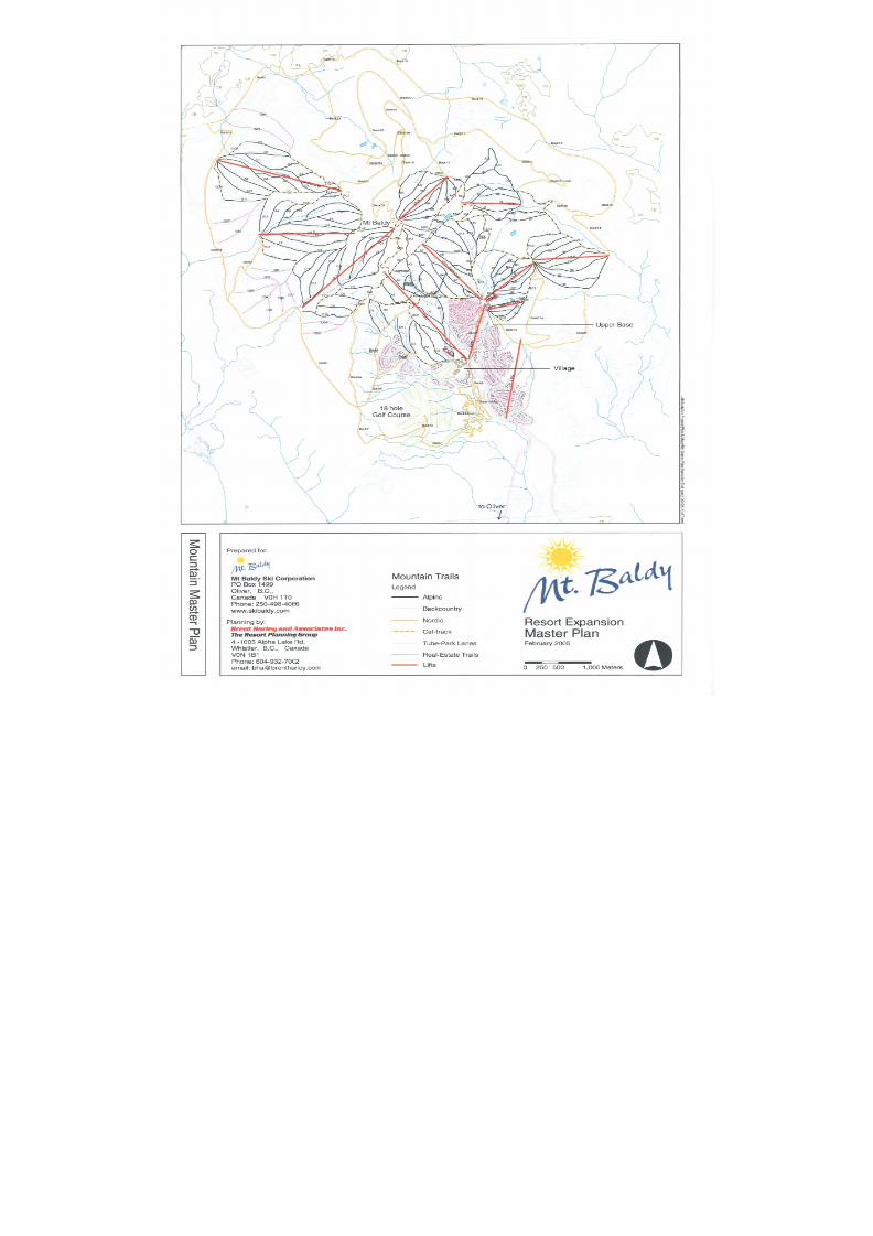
LLi i f f t t ss aannd d T T r r aai i l l ss
At buildout, Mt. Baldy will have 13 ski lifts servicing over 150 ski trails. The skiable terrainat buildout will total approximately 700 ha (1,725 acres) of developed trails and gladeswith a CCC of 6,744 skiers per day.
As planned, a limited number of select runs will include snowmaking to ensure that Mt
Baldy is open for limited early season skiing and to reinforce snowpack on high-usecirculation trails to the base areas and real estate. Likewise, a limited amount of terrain,connector and Nordic trails will be equipped with night skiing / pedestrian lighting.
The trail layout has been designed to carefully adhere to the perceived distribution of theskier marketplace. At buildout Mt. Baldy will be very close to a perfect match with themarket distribution, with only a slight excess of Intermediate Terrain and a lack of ExpertTerrain (a function of an absence of slopes with steeper gradients).
BBaac c k k c c oou u nnt t r r y y A Ad d v v eennt t u u r r ee
Consistent with the desire to create a unique resort product, and to ensure that theexperiences at Mt. Baldy revolve around ‘mountain play’ and an expanded sense of
alpine recreation, additional infrastructure on backcountry and Nordic trail networks havebeen incorporated throughout the Alpine skiing area. Primary to this will be the pay-for-use “Sherpa” return rides. At select focal points, adventure oriented visitors will be ableto explore the terrain beyond lift serviced access and be picked up by Sherpas (largecapacity snowmobiles) and returned to the base of the resort. Complementing this, thoseon the adventure trails (backcountry alpine trails and Nordic networks) will be providedwith opportunities to enjoy facilities at special gathering areas while in the backcountryenvirons. These areas will include small park-like facilities such as covered gazebos,picnic areas, viewpoints with seating for gathering and resting, as well as potential yurtsand small cabins for warming up, relaxing, and possibly overnight stays.
8/12/2019 Mount Baldy
http://slidepdf.com/reader/full/mount-baldy 6/322
Mount BaldyResort Expansion
Master Plan February 2005
Page IV Brent Harley & Associates Inc.
The Resort Planning Group
R R eessoor r t t T T r r aai i l l N N eet t w w oor r k k
Also adventure oriented, the Resort Trail Network has been designed to accommodate awide range of user groups in an all season capacity.
During the winter, it will enable Nordic and backcountry skiers to enjoy a very expandable
56 km of Nordic exclusive trails around the periphery of the mountain, while alsoaccessing higher elevation terrain by utilizing the alpine ski lift infrastructure. From thetop of any Nordic accessible lift, the Nordic skiers will always have a means of returningto the lower elevation cross-country trails via a shallow grade return trail (less than 12%).
As planned, the Nordic trail system adds 561 skiers to the CCC of Mt. Baldy.
In the summer, these trails will be utilized in both an informal and formalized capacity forbird watching, natural history, wildlife, guided nature walks, hiking, biking and mountainbiking. A hierarchy of trails will be designed to accommodate different needs and skilllevels. In its most formal, it is anticipated that a portion of the trail network will be paved,connecting built areas within the resort. At the other end of the spectrum, trails will berugged, narrow singletrack winding throughout the whole of the Controlled Recreation
Area.
O O t t hheer r O O nn- - M M oou u nnt t aai i nn A At t t t r r aac c t t i i oonnss
In addition to the skiing, the backcountry adventure facilities and the resort trail network,other on-mountain attractions include a Tube Park, the Mountain Spa/Park and the GolfCourse.
The Tube Park will cater to non-skiing snowplay. Its high visibility location adjacent to theVillage will help animate the winter play character of Mt. Baldy. This facility adds 120guests to the resort’s capacity.
Similarly, a “Mountain Spa/Park” has been planned for incorporation into the Village.This will be a water-based amenity for Mt. Baldy. It will include a water park providingindoor/outdoor all season swimming as well as specialized skills based water activities
such as surfing, white water kayaking and boogie boarding. Directly tied to, andassociated with this will be spa facilities for physiotherapy, massage, as well as awellness centre and sports medicine clinic. This facility will act as a significant attractionin its own right, adding another 350 guests to Mt. Baldy’s carrying capacity.
Plans for the eighteen-hole Mt. Baldy Golf Course have been incorporated in the overallMaster Plan. It will stage from the Village core, winding through undulating terrain andultimately returning to the Village. The intent is to create a high calibre resort course thatwill offer visitors and residents at Mount Baldy a satisfying and rewarding golf experience.The mountain setting and cooler summer temperatures will prove to be a complement tothe high temperature ‘arid’ golf found in Oliver and Osoyoos. Collectively, the addition ofthe Mt. Baldy course will add a new dimension to the golf destination market of theSouthern Okanagan. Rounding out the golf product, a driving range and teaching
academy will be developed in the area of the tubing and beginner skiing slopes in front ofthe Village, thereby giving those winter oriented facilities a summer use.
R R eessoor r t t C C aa p paac c i i t t y y
At buildout, the Comfortable Carrying Capacity of Mt. Baldy’s attractions (the alpineskiing, the Nordic trails, the Tube Park and the Mountain Spa) will total 7,776 guests perday. The base area facilities and residential development have been planned to balancewith and complement this number.
8/12/2019 Mount Baldy
http://slidepdf.com/reader/full/mount-baldy 7/322
Mount BaldyResort Expansion
Master Plan February 2005
Page V Brent Harley & Associates Inc.
The Resort Planning Group
BBAASSEE AARREEAA DDEEVVEELLOOPPMMEENNTT
The Master Plan for the proposed base area development at Mt. Baldy has been plannedto take on a ‘retreat’ and ‘escape’ ambiance, complementing the mountain’s naturalattributes, capacities and proposed facilities. The design and layout of the base areafacilities are consistent with the overall vision for Mt. Baldy. An emphasis has been
placed on creating a compact, pedestrian oriented development footprint. Direct linkagesto and from the base areas and resort residential development areas will be incorporatedwith the establishment of the highly integrated Nordic trail network enabling ski to / skifrom access throughout the resort.
The built space requirements are directly correlated to the carrying capacity of theresort’s facilities. At buildout, the base area and on-mountain facilities at Mt. Baldy mustprovide for the needs of approximately 7,776 guests and residents. In total,approximately 14,500 square metres of built space will be in place at buildout.
Mt. Baldy will effectively have two base areas as focal points; the Upper Base and theVillage. These two areas are linked by ski trails, the trail network and a ‘people-mover’lift. Infilling the lands between the bases will be a variety of resort residential
accommodations. Integrated within these subdivisions will be affordable resident andemployee housing as a means of ensuring a sustained presence of a population base toboth service and reinforce the character of Mt. Baldy.
U U p p p peer r BBaassee
The Upper Base has its focus defined by the main ski trails serviced by the Eagle Chairand the Sugar Lump lifts and trails. It will be primarily day-use oriented and includes acore of buildings housing visitor services, intimate restaurants and lounges, and a smallnumber of accommodation units all oriented to access, view and celebrate Mt. Baldy. Theexisting day lodge will be converted to include administration and employee facilities.The upper terminal of the people mover is located in close proximity to the Upper Basecore. A low gradient trail (10% slope) will lead guests as pedestrians, Nordic skiers,
bikers, skiers and snowboarders from the Upper Base back down to the Village. Day useparking lots have been designed to be within acceptable walking distance.
M M t t .. BBaal l d d y y V V i i l l l l aag g ee
Mt. Baldy Village is located about one kilometre south of and approximately 100 verticalmetres below the Upper Base. The focal point is located in close proximity to the base ofthe alpine skiing as serviced by Lift D, and directly connected to the Nordicskiing/mountain biking trail system. The core of the Village will include a variety ofbuildings housing hotels, condo-tels, retail outlets, convention seminar facilities, themountain resort spa and resort services; all designed to meet the needs of destinationand day use guests visiting Mt. Baldy. Additionally, the first and last holes of theeighteen-hole golf course begin and end, at the Village; the tube park and beginnerteaching area (serviced by a magic carpet lift) is located immediately uphill from the
Village core, and; the Mountain Spa/Park is located within the Village core. The peoplemover originates at the core area and is adjacent to the return trail coming down from theUpper Base.
R R eessoor r t t R R eessi i d d eennt t i i aal l A Ar r eeaass
A series of resort residential areas incorporating a variety of public and privateaccommodation have been designed to infill between, and around, the Upper Base andVillage areas. These developments are located to keep the development footprintcompact, pedestrian-oriented and ski-to / ski-from capable. All of the development hasbeen carefully placed to respect streams and associated riparian zones. The desired
8/12/2019 Mount Baldy
http://slidepdf.com/reader/full/mount-baldy 8/322
Mount BaldyResort Expansion
Master Plan February 2005
Page VI Brent Harley & Associates Inc.
The Resort Planning Group
effect is to incorporate the buildings, to the greatest degree possible, into the landscape.The design guidelines will require development to be ‘green-building’ oriented.
At buildout, it is proposed that Mt. Baldy will have a total of 7,892 bed units of which 45%will allocated for public use (available for any interested party to rent for short term use),and 55% for private use (not available for short term rental).
As planned, there will be approximately 3,590 public bed units equating to 379 hotelrooms 303 multi-family / condotel rooms, 52 bed and breakfast homes and 275 cabins.
All public accommodation units will be developed with rental pool covenants, allowingowners to purchase the units, subject to restricted use. All design, development andconstruction of public accommodation must adhere to the Mt. Baldy Design Guidelinesand associated conformance-oriented approval process.
Similarly, privately held accommodation will total 4,302 bed units. This equates to 428single family units, 226 multi-family units and 30 recreation vehicle stalls. All privateaccommodation development will be subject to Design Guidelines and a conformance-oriented approval process.
E E mm p pl l ooy y eeee A Ac c c c oommmmood d aat t i i oonn
To be successful Mt. Baldy will need a wide variety of full-time residents to attend to theoperational and administrative aspects of enterprise at the resort. Just as a wide varietyof employee types coincide with a wide variety of jobs, employee accommodation mustconsist of a wide range of housing types. Anticipating this, employee or resident-restricted housing has been integrated throughout the plan. It includes a spectrum ofaccommodation, ranging from rental units made available to the transient seasonalworkers; to multi-family rental units; to employee restricted rental suites within individualhomes; to resident/employee-restricted, fee simple, multi- and single-family units madeavailable for purchase. Ten percent of the total bed units at Mount Baldy have beenassigned for employee/resident use. At buildout, this translates to a total of 770 bedunits. Employee and resident restricted housing will be organized administered,monitored and enforced by the MBSC.
P P aar r k k i i nng g
Based on the buildout resort capacity, parking must be available for approximately 7,775guests and residents. Assuming that 85% of this capacity will arrive by car, and basedon an average of 3 occupants per car, the parking areas must be capable ofaccommodating about 2,200 cars. The remaining 15% of guests would be expected toarrive by bus. Assuming 40 visitors per bus, approximately 29 buses would have to beaccommodated on a busy day. The actual parking requirement will be a function of theestablishment of an expanded shuttle system from Oliver and Osoyoos.
Day use parking has been planned and delineated to accommodate 670 cars in theUpper Base parking lots. Likewise, parking lot capacity in the Village totals 720 cars.
All parking requirements associated with the Village core commercial development andpublic accommodation are provided for in underground parking below the core forapproximately 400 cars. The remaining car parking requirements are attached to the siteof each of the residential developments.
The resort roads have been designed to be wide enough for two-way through traffic. Thiswill minimize the cut and fill requirements to build the roads, reduce the paved roadsurface area, and reduce the amount of snow clearing and snow storage. This in turn, willminimize the environmental impact of the roads developed at Mount Baldy. As such,there will be no on street parking permitted.
8/12/2019 Mount Baldy
http://slidepdf.com/reader/full/mount-baldy 9/322
Mount BaldyResort Expansion
Master Plan February 2005
Page VII Brent Harley & Associates Inc.
The Resort Planning Group
DDeessi i g g nn G G u u i i d d eel l i i nneess
Design Guidelines will be developed to ensure consistency of character, constructionquality and built form performance (e.g. Energy efficiency, product procurement and othergreen building standards) throughout the resort. These will be applied to all buildings in
the base areas, including on-mountain facilities and the residential and commercialbuildings throughout the resort. The guidelines will be created and put in placeimmediately so as to ensure that the tone, ambiance and character of the first phases ofresort development are consistent with the envisioned result at buildout. Acknowledgingthat the Design Guidelines are critical to both the short and long-term success of theresort, Mt. Baldy Ski Corporation will ensure that the appropriate covenants are placed onall development at the resort, regardless of the who the ultimate developer may be.MBSC will maintain control of the administration and enforcement of the DesignGuidelines.
Z Z oonni i nng g
The development lands at Mount Baldy will be zoned based on submissions and dialogue
with the Regional District of Kootenay Boundary. To create the desired character,ambiance and quality, it is anticipated that a Comprehensive Development Zone will becreated specifically for Mt. Baldy.
SSUUSSTTAAIINNAABBIILLIITT Y Y CCHHAARRAACCTTEERRIISSTTIICCSS
It is the intent of the Mount Baldy Ski Corporation to create a resort community and skiarea product that is premised on the principles of stewardship and responsibility. Theseprinciples have informed the planning and design processes. Through the adoption ofbest management practices that, in many cases, exceed the relevant legislation, MBSCseeks to ensure that natural values are protected, that associated ecological integrity isrespected and that the operations of the ski area product continually strive to improvetheir environmental performance through informed procurement and leading-edge
technologies.
IImmpplleemmeennttaattiioonn SSttr r aatteeggyy
In order to achieve a balanced, well considered and coordinated development plan forachieving the planned end result at buildout, a detailed phasing strategy has beencreated. The Implementation Strategy anticipates four phases of development. Eachphase takes into account all aspects of the mountain plan such that it will be a completedwell balanced resort product at the end of each stage of the development process. Thisbalance ensures that base area facilities are integrated and supportive of the mountaincapacity at any given time, and that lift infrastructure is capable of servicing the skiers ina manner consistent with both their expectations as well as the goal of providing a unique
and desirable mountain experience.
Each phase will be market driven. A phase could be as short as one to two years or aslong as necessary for the market to create sufficient demand to move to the next phase.Ultimately, economic conditions, financial costs and/or emerging business opportunitieswill dictate the pace by which the phasing plan eventually unfolds. Typically, subsequentphases of development are not triggered until a given threshold of utilization is achievedwith the existing infrastructure and trail opportunities (generally 35% utilization).
8/12/2019 Mount Baldy
http://slidepdf.com/reader/full/mount-baldy 10/322
Mount BaldyResort Expansion
Master Plan February 2005
Page VIII Brent Harley & Associates Inc.
The Resort Planning Group
As planned, Phase One will see the CCC of the resort grow from its existing 646 guestsper day to 1,987. Subsequently Phase Two grows to 4,229 guests, Phase Three to5,707 guests, and; Phase Four to 7,776 guests at buildout.
SSeer r vviicciinngg aanndd IInnf f r r aassttr r uuccttuur r ee
The current water supply and sanitary sewer infrastructure at Mt. Baldy were designed forthe existing development, which in total represents a buildout capacity of approximately1,000 bed units. The phased development plan represents an 800% increase in thecapacity requirements. Associated with the development plan, water supply and sanitarysewer infrastructure will be expanded. The infrastructure plan illustrates that the site iscapable to accommodate the necessary expansion.
In the initial phases of the implementation of the Mt. Baldy development plan, additionalassessment studies and detailed engineering will be completed to accommodate theplanned development.
Further, in an effort to remain consistent to the values and vision of the Resort ExpansionPlan, the MBSC has committed to undertaking a detailed ‘alternative and renewable
power systems capacity study’ to explore the feasibility of integrating local renewableenergy systems into the resort development.
CCoonncclluussiioonnss
The Expansion Master Plan carefully outlines a comprehensive approach to ensure thelong-term success of the Mt. Baldy Resort. The unique all-mountain product, thecompetitive positioning, the strong sense of environmental responsibility and the carefullyconstructed Implementation Plan provide the tools requisite to ensure that Mt. Baldyprovides a successful complement to the Southern Okanagan’s existing tourismproducts. This methodical expansion of Mt. Baldy should prove to be very positive for allinvolved, adding significant economic and social benefit to the South Okanagan Region,
the Osoyoos Indian Band, and to the Province of British Columbia in general.
8/12/2019 Mount Baldy
http://slidepdf.com/reader/full/mount-baldy 11/322

8/12/2019 Mount Baldy
http://slidepdf.com/reader/full/mount-baldy 12/322
8/12/2019 Mount Baldy
http://slidepdf.com/reader/full/mount-baldy 13/322
Mount BaldyResort Expansion
Master Plan February 2005
Page i Brent Harley & Associates Inc.
The Resort Planning Group
TTaabbllee oof f CCoonntteennttss
1.0 INTRODUCTION.......................................................................................................................................................................1
1.1 PROJECT OVERVIEW...............................................................................................................................................................1 1.2 THE PROPONENT....................................................................................................................................................................2 1.3 PLANNING PROCESS ...............................................................................................................................................................3 1.4 THE PROJECT VISION..............................................................................................................................................................3 1.5 DEVELOPMENT GOALS AND OBJECTIVES .................................................................................................................................5 1.6 FIRST N ATIONS RELATIONSHIP ................................................................................................................................................6
2.0 EXISTING RESORT CONTEXT................................................................................................................................................9
2.1 LOCATION...............................................................................................................................................................................9 2.2 ACCESS..................................................................................................................................................................................9 2.3 CURRENT REGIONAL CONTEXT..............................................................................................................................................10
2.3.1 Regional Planning Policy ...........................................................................................................................................11 2.4 HISTORIC CONTEXT ..............................................................................................................................................................11 2.5 EXISTING SKIING F ACILITIES ..................................................................................................................................................12
2.5.1 Existing Ski Lifts.........................................................................................................................................................14 2.5.2 Existing Ski Trails.......................................................................................................................................................14
2.5.3 Existing Nordic Trails ............... ................ ................ ................ ................ ................ .................... ................ ..............15 2.5.4 Existing Comfortable Carrying Capacity ....................................................................................................................16 2.6 EXISTING SKIER RELATED BUILT SPACE ................................................................................................................................19 2.7 EXISTING OVERNIGHT ACCOMMODATIONS .............................................................................................................................19 2.8 EXISTING P ARKING................................................................................................................................................................19 2.9 EXISTING STUDY AREA L AND USE .........................................................................................................................................19 2.10 EXISTING DEVELOPMENT OPPORTUNITIES .............................................................................................................................20
3.0 MOUNTAIN ANALYSIS..........................................................................................................................................................21
3.1 INTRODUCTION .....................................................................................................................................................................21 3.2 MOUNTAIN TERRAIN ASSESSMENT.........................................................................................................................................23
3.2.1 Slope Analysis ................ ................ ................ ................ ................ ............... ................ ................... ................ .........23 3.2.2 Elevation Analysis......................................................................................................................................................25 3.2.3 Aspect Analysis..........................................................................................................................................................27 3.2.4 Fall-Line Analysis.......................................................................................................................................................29 3.2.5 Climatological Analysis ............... ................ ................ ................ ................ ................ ................... ................. ...........31 3.2.6 Avalanche Hazard and Control..................................................................................................................................32
3.3 B ASE AREA TERRAIN ASSESSMENT .......................................................................................................................................33 3.3.1 Base Area Slope Analysis..........................................................................................................................................33 3.3.2 Base Area Elevation Analysis ............... ................ ............... ................ ............... ................ .................... ................ ...34 3.3.3 Base Area Aspect and Solar Access Analysis...........................................................................................................34
3.4 ENVIRONMENTAL CONDITIONS...............................................................................................................................................38 3.4.1 Ecology .............. ................ ................ ................ ................ ................ ................ .................... ................ ................ ....39 3.4.2 Strategic Land Use Plans ..........................................................................................................................................39
3.4.2.1 Okanagan-Shuswap LRMP...................................................................................................................................39 3.4.2.2 Kootenay-Boundary LRMP....................................................................................................................................39
3.4.3 Wildlife ............... ................ ................ ................ ................ ................ ................ .................... ................ ................ ....40 3.4.3.1 Ungulate Winter Range ................ ................ ................ ................ ................ ................ ................... ................ ......41 3.4.3.2 Rare and Endangered Species .............. ................. ................ ................ ................ ................ ................... ...........41 3.4.3.3 Wildlife Habitat Suitability ............... ............... ................ ................ ............... ................ ................... ................ ......41 3.4.3.4 Elk..........................................................................................................................................................................42 3.4.3.5 Mule Deer..............................................................................................................................................................45 3.4.3.6 Lynx.......................................................................................................................................................................46
3.4.3.7 White-Headed Woodpecker .............. ................ ................ ................ ................ ................ .................... ................47 3.4.3.8 Williamson’s Sapsucker ............... ................ ................ ............... ................ ................ .................... ................ ......47 3.4.3.9 Bear Management Plan.........................................................................................................................................47
3.4.4 Fisheries and Aquatic Resources ..............................................................................................................................49 3.4.4.1 Erosion And Sediment Control Best Management Practices................................................................................51 3.4.4.2 Riparian and Fish Habitat......................................................................................................................................51
3.4.5 Vegetation..................................................................................................................................................................55 3.4.5.1 Old Growth Management Areas............................................................................................................................56
3.4.6 Summary and Recommendations..............................................................................................................................59 3.5 GEOTECHNICAL CONSIDERATIONS.........................................................................................................................................62
8/12/2019 Mount Baldy
http://slidepdf.com/reader/full/mount-baldy 14/322
Mount BaldyResort Expansion
Master Plan February 2005
Page ii Brent Harley & Associates Inc.
The Resort Planning Group
4.0 EXPANSION MASTER PLAN ................ ................ ................ ................ ................ ................ .................... ................. ...........63
4.1 MOUNTAIN M ASTER PLAN .....................................................................................................................................................63 4.1.1 Mountain Development Goals....................................................................................................................................63 4.1.2 Preliminary Terrain Capacity Analysis .......................................................................................................................64 4.1.3 Proposed Ski Trails....................................................................................................................................................67
4.1.3.1 Alpine Trails............ ................ ................ ............... ................ ................ ................ .................... ................ ............69 4.1.3.2 Nordic Trails ............... ................ ................ ................ ................ ................ ................ ..................... ................ ......85 4.1.3.3 Additional Adventure Trail Infrastructure..... ............... ................ ................ ................ ................ ................... ........86
4.1.4 Alpine Terrain Distribution Analysis...........................................................................................................................87 4.1.5 Alpine Lift Inventory and Analysis ..............................................................................................................................88 4.1.6 Mountain Operations Facilities...................................................................................................................................92
4.1.6.1 Sherpa-Based Backcountry Return Operations ............... ................ ................ ............... ................ ................... ...92 4.1.6.2 Ski Patrol Facilities ............... ................ ................ ............... ................ ................ .................... ................ ..............96 4.1.6.3 Mountain Access Roads........................................................................................................................................96 4.1.6.4 Snowmaking..........................................................................................................................................................97 4.1.6.5 Lighting..................................................................................................................................................................97 4.1.6.6 Grooming...............................................................................................................................................................98
4.1.7 Public Snowmobile Access Plan..............................................................................................................................100 4.2 B ASE AREA DEVELOPMENT .................................................................................................................................................101
4.2.1 Base Area Development Goals................................................................................................................................101 4.2.2 Development Areas ............... ................ ................ ................ ................ ................ ................... ................ ...............101 4.2.3 Built Space Requirements .......................................................................................................................................102 4.2.4 Overnight Accommodation.......................................................................................................................................103 4.2.5 Employee Accommodation .............. ................. ................ ................ ................ ................ ................... ................ ....104 4.2.6 Golf Facilities ............... ................ ................ ............... ................ ................ ................ ................... ................ ..........105 4.2.7 Mountain Spa/Park Facilities ...................................................................................................................................105 4.2.8 Parking.....................................................................................................................................................................105 4.2.9 Design Guidelines....................................................................................................................................................106
4.3 ZONING ..............................................................................................................................................................................106 4.4 SUSTAINABILITY CHARACTERISTICS .....................................................................................................................................106
5.0 IMPLEMENTATION STRATEGY..........................................................................................................................................113
5.1 EXPANSION PLAN PHASING .................................................................................................................................................113 5.2 PHASE ONE ........................................................................................................................................................................116
5.2.1 Mountain Development Plan – Phase One..............................................................................................................116 5.2.1.1 Phase One Trail Development ................ ................ ............... ................ ................ ................ .................... .........118 5.2.1.2 Phase One Lift Specifications, Balance, CCC and Market Distribution...............................................................121
5.2.2 Base Area Development Plan – Phase One............................................................................................................123
5.3 PHASE TWO........................................................................................................................................................................126 5.3.1 Mountain Development Plan – Phase Two..............................................................................................................126 5.3.1.1 Phase Two Trail Development .............. ................ ................ ................ ................ ................ .................. ............128 5.3.1.2 Phase Two Lift Specifications, Balance, CCC and Market Distribution...............................................................133
5.3.2 Base Area Development Plan – Phase Two............................................................................................................135 5.4 PHASE THREE.....................................................................................................................................................................138
5.4.1 Mountain Development Plan – Phase Three ...........................................................................................................138 5.4.1.1 Phase Three Trail Development..........................................................................................................................140 5.4.1.2 Phase Three Lift Specifications, Balance, CCC and Market Distribution........ ................ ................ ................ ....146
5.4.2 Base Area Development Plan – Phase Three .........................................................................................................148 5.5 PHASE FOUR ......................................................................................................................................................................151
5.5.1 Mountain Development Plan – Phase Four .............................................................................................................151 5.5.1.1 Phase Four Trail Development............................................................................................................................153 5.5.1.2 Phase Four Lift Specifications, Balance, CCC and Market Distribution....... ................ ................ ................ .......159
5.5.2 Base Area Development Plan – Phase Four ...........................................................................................................161 5.6 CONTROLLED RECREATION AREA BOUNDARY......................................................................................................................165
6.0 SERVICING AND INFRASTRUCTURE................................................................................................................................167 6.1 W ATER...............................................................................................................................................................................167 6.2 S ANITARY SEWER SYSTEM..................................................................................................................................................170 6.3 SOLID W ASTE DISPOSAL .....................................................................................................................................................172 6.4 POWER...............................................................................................................................................................................172
7.0 COMPETITIVE RESORTS ASSESSMENT..........................................................................................................................173
7.1 M ARKET TRENDS ................................................................................................................................................................173 7.2 M ARKET POSITION ..............................................................................................................................................................175
8/12/2019 Mount Baldy
http://slidepdf.com/reader/full/mount-baldy 15/322
Mount BaldyResort Expansion
Master Plan February 2005
Page iii Brent Harley & Associates Inc.
The Resort Planning Group
8.0 POTENTIAL SOCIO-ECONOMIC IMPACTS ............... ................ ................ ................ ................ .................... ................ ....177
9.0 MANAGEMENT AND OWNERSHIP STRUCTURE.............. ................ ................. ................ ................ .................. ............178
9.1 FINANCIAL C APABILITIES .....................................................................................................................................................180
10.0 CONCLUSIONS ............... ................. ................ ................ ................. ................ ................. ................... ................. .........182
11.0 APPENDICES...................................................................................................................................................................183
8/12/2019 Mount Baldy
http://slidepdf.com/reader/full/mount-baldy 16/322
Mount BaldyResort Expansion
Master Plan February 2005
Page iv Brent Harley & Associates Inc.
The Resort Planning Group
TTAABBLLEE OOFF FFIIGGUURREESS
FIGURE 1-1 REGIONAL CONTEXT..............................................................................................................................................................1 FIGURE 1-2 LOCATION CONTEXT ..............................................................................................................................................................8 FIGURE 2-1 EXISTING MOUNT B ALDY TRAIL M AP – ARTIST RENDERING...................................................................................................12 FIGURE 2-2 EXISTING MOUNT B ALDY TRAIL M AP – PLANIMETRIC VIEW....................................................................................................13 FIGURE 2-3 EXISTING B ASE AREA CONDITIONS ......................................................................................................................................18 FIGURE 3-1 IDENTIFIED STUDY AREA......................................................................................................................................................22 FIGURE 3-2 SLOPE ANALYSIS.................................................................................................................................................................24 FIGURE 3-3 ELEVATION ANALYSIS ..........................................................................................................................................................26 FIGURE 3-4 ASPECT ANALYSIS...............................................................................................................................................................28 FIGURE 3-5 F ALL-LINE AND PRELIMINARY POD DEVELOPMENT ANALYSIS.................................................................................................30 FIGURE 3-6 B ASE AREA SLOPE ANALYSIS ..............................................................................................................................................35 FIGURE 3-7 B ASE AREA ELEVATION ANALYSIS........................................................................................................................................36 FIGURE 3-8 B ASE AREA ASPECT AND SOLAR ACCESS ANALYSIS .............................................................................................................37 FIGURE 3-9 ACTUAL AND EXTRAPOLATED HIGH HABITAT SUITABILITY POLYGONS WITHIN THE STUDY AREA BOUNDARY................................44 FIGURE 3-10 MCKINNEY COMMUNITY W ATERSHED BOUNDARY. ............... ................. ................ ................ ................ ................ ..............50 FIGURE 3-11 STATUS OF KNOWN FISH DISTRIBUTIONS WITHIN THE STUDY AREA. ......................................................................................53 FIGURE 3-12 FISH DISTRIBUTION FOR MCKINNEY CREEK. ................ ................ ................ ................. ................ ................ ................ ......53 FIGURE 3-12 FISH DISTRIBUTION FOR MCKINNEY CREEK. ................ ................ ................ ................. ................ ................ ................ ......54 FIGURE 3-13 R UMEX PAUCIFOLIUS (ALPINE SORREL) AND M IMULUS BREWERI (BREWER’S MONKEYFLOWER). ..........................................56
FIGURE 3-14 LOCATION OF DRAFT OGMAS ESTABLISHED WITHIN THE KOOTENAY AND K AMLOOPS MSRM REGIONS.................................58 FIGURE 4-1 3D VIEW OF PRELIMINARY MOUNTAIN DEVELOPMENT PODS .................................................................................................66 FIGURE 4-2 MOUNTAIN PLAN SUMMARY – TRAILS BY SKIER CLASS .........................................................................................................68 FIGURE 4-3 MT. B ALDY M ASTER PLAN – PLAN VIEW...............................................................................................................................76 FIGURE 4-3-1 MT. B ALDY M ASTER PLAN – LIFT F & G AREA...................................................................................................................77 FIGURE 4-3-2 MT. B ALDY M ASTER PLAN – LIFT C AREA ..........................................................................................................................78 FIGURE 4-3-3 MT. B ALDY M ASTER PLAN – LIFT J & M AREA ...................................................................................................................79 FIGURE 4-3-4 MT. B ALDY M ASTER PLAN – LIFT A, B, D, E, N & P AREA .................................................................................................80 FIGURE 4-3-5 MT. B ALDY M ASTER PLAN – LIFT Q AREA..........................................................................................................................81 FIGURE 4-3-6 MT. B ALDY M ASTER PLAN – LIFT H AREA ..........................................................................................................................82 FIGURE 4-4 MOUNTAIN M ASTER PLAN – VIEW FROM SOUTH WEST..........................................................................................................83 FIGURE 4-5 MOUNTAIN M ASTER PLAN – VIEW FROM NORTH E AST ..........................................................................................................84 FIGURE 4-6 LIFT SUMMARY ....................................................................................................................................................................89 FIGURE 4-7 MOUNTAIN OPERATIONS F ACILITIES .....................................................................................................................................95 FIGURE 4-8 PROPOSED LIGHTING AND SNOWMAKING..............................................................................................................................99 FIGURE 4-9 VILLAGE M ASTER PLAN .....................................................................................................................................................108 FIGURE 4-10 VILLAGE RESIDENTIAL TYPES...........................................................................................................................................109
FIGURE 4-11 UPPER B ASE ...................................................................................................................................................................110 FIGURE 4-12 VILLAGE B ASE .................................................................................................................................................................111 FIGURE 4-13 B ASE AREA 3D VIEW.......................................................................................................................................................112 FIGURE 5-1 MOUNTAIN PLAN PHASING SUMMARY.................................................................................................................................114 FIGURE 5-2 B ASE AREA PHASING SUMMARY ........................................................................................................................................115 FIGURE 5-3 PHASE ONE MOUNTAIN DEVELOPMENT PLAN .....................................................................................................................117 FIGURE 5-4 PHASE ONE B ASE AREA DEVELOPMENT PLAN ....................................................................................................................125 FIGURE 5-5 PHASE TWO MOUNTAIN DEVELOPMENT PLAN.....................................................................................................................127 FIGURE 5-6 PHASE TWO B ASE AREA DEVELOPMENT PLAN ...................................................................................................................137 FIGURE 5-7 PHASE THREE MOUNTAIN DEVELOPMENT PLAN..................................................................................................................139 FIGURE 5-8 PHASE THREE B ASE AREA DEVELOPMENT PLAN ................................................................................................................150 FIGURE 5-9 PHASE FOUR MOUNTAIN DEVELOPMENT PLAN ...................................................................................................................152 FIGURE 5-10 PHASE FOUR B ASE AREA DEVELOPMENT PLAN ................................................................................................................164 FIGURE 5-11 PROPOSED CONTROLLED RECREATION AREA METES AND BOUNDS ..................................................................................166 FIGURE 6-1 PRELIMINARY W ATER SUPPLY INFRASTRUCTURE................................................................................................................169 FIGURE 6-2 PRELIMINARY S ANITARY SEWER SYSTEM ...........................................................................................................................171
8/12/2019 Mount Baldy
http://slidepdf.com/reader/full/mount-baldy 17/322
Mount BaldyResort Expansion
Master Plan February 2005
Page v Brent Harley & Associates Inc.
The Resort Planning Group
LLiisstt oof f TTaabblleess
T ABLE 1. ASSOCIATION WITH REGIONAL POPULATION CENTRES _______________________________________________________ 10 T ABLE 2. EXISTING MOUNT B ALDY LIFTS ________________________________________________________________________ 14
T ABLE 3. EXISTING MOUNT B ALDY E AGLE CHAIR SKI RUNS __________________________________________________________ 14 T ABLE 4. EXISTING MOUNT B ALDY MCKINNEY T-B AR SKI RUNS _______________________________________________________ 15 T ABLE 5. MOUNT B ALDY DESIGN CRITERIA VS. CASP STANDARDS ____________________________________________________ 16 T ABLE 6. SKI AREA SLOPE ANALYSIS CRITERIA ___________________________________________________________________ 23 T ABLE 7. RESORT AREA ELEVATION AND SKIABLE VERTICAL ANALYSIS _________________________________________________ 25 T ABLE 8. RESORT B ASE AREA COMPARISON _____________________________________________________________________ 31 T ABLE 9. AVERAGE B ASE DEPTH OF SNOW-PACK (MOUNT B ALDY IN-HOUSE D ATA) ________________________________________ 31 T ABLE 10. GRANO CREEK SNOW PILLOW D ATA (2004-2005)_________________________________________________________ 32 T ABLE 11: KOOTENAY-BOUNDARY LRMP IMPLEMENTATION STRATEGY OBJECTIVES WITHIN THE B-I01 KETTLE-GRANBY RESOURCE
M ANAGEMENT ZONE. __________________________________________________________________________________ 40 T ABLE 12: ECOSYSTEM UNITS AND STRUCTURAL STAGES RATED AT MODERATE, MODERATELY HIGH, AND HIGH HABITAT SUITABILITY FOR ELK
WITHIN THE STUDY AREA. _______________________________________________________________________________ 43 T ABLE 13: ECOSYSTEM UNITS AND STRUCTURAL STAGES RATED AS MODERATE, MODERATELY HIGH, AND HIGH HABITAT SUITABILITY FOR
MULE DEER WITHIN THE STUDY AREA. ______________________________________________________________________ 45 T ABLE 14: ECOSYSTEM UNITS AND STRUCTURAL STAGES RATED AS MODERATE AND HIGH HABITAT SUITABILITY FOR LYNX WITHIN THE STUDY
AREA. _____________________________________________________________________________________________ 47 T ABLE 15: RESERVE ZONE AND M ANAGEMENT ZONE WIDTHS FOR STREAMS WITHIN A COMMUNITY W ATERSHED. __________________ 49
T ABLE 16: RIPARIAN M ANAGEMENT AREA BEST MANAGEMENT PRACTICES _______________________________________________ 52 T ABLE 17: OGMAS LOCATED WITHIN THE STUDY AREA BOUNDARY AND ESTIMATED CLEARING REQUIRED TO ACCOMMODATE PLANNED
INFRASTRUCTURE. ____________________________________________________________________________________ 57 T ABLE 18: VEGETATION AND WILDLIFE HABITAT RESOURCE VALUES WITHIN THE STUDY AREA. _________________________________ 59 T ABLE 19: W ATER QUALITY, RIPARIAN AND FISH H ABITAT V ALUES WITHIN THE STUDY AREA _________________________________ 61 T ABLE 20. SKIER DENSITY CRITERIA VS. CASP STANDARDS _________________________________________________________ 64 T ABLE 21. LIFT SERVICED VERTICAL OF LOWER M AINLAND SKI AREAS __________________________________________________ 65 T ABLE 22. SUMMARY OF DEVELOPED SKI TERRAIN BY PHASE AND ABILITY LEVEL (HA) ______________________________________ 67 T ABLE 23. ALPINE TRAIL INVENTORY – BUILD OUT CONDITION ________________________________________________________ 69 T ABLE 24. PROPOSED NORDIC TRAIL SPECIFICATIONS _____________________________________________________________ 86 T ABLE 25. PROPOSED LIFT SPECIFICATIONS _____________________________________________________________________ 90 T ABLE 26. UPHILL C APACITY ASSESSMENT ______________________________________________________________________ 90 T ABLE 27. SKIER DISBURSEMENT ASSESSMENT – BUILD OUT ________________________________________________________ 91 T ABLE 28. PRELIMINARY SHERPA C APACITY ASSESSMENT ___________________________________________________________ 93 T ABLE 29. D AILY GROOMING VOLUMES BY PHASE AND BY SKIER CLASS _________________________________________________ 98 T ABLE 30. BUILDOUT SPACE USE ALLOCATION __________________________________________________________________ 103 T ABLE 31. BUILDOUT BED UNIT SUMMARY ______________________________________________________________________ 104 T ABLE 32. SUMMARY OF PHASE-BY-PHASE C APACITIES ____________________________________________________________ 113 T ABLE 33. ALPINE TRAIL INVENTORY – PHASE ONE _______________________________________________________________ 118 T ABLE 34. PROPOSED LIFT SPECIFICATIONS – PHASE ONE _________________________________________________________ 121 T ABLE 35. UPHILL C APACITY ASSESSMENT _____________________________________________________________________ 121 T ABLE 36. PHASE ONE SPACE USE REQUIREMENTS ______________________________________________________________ 124 T ABLE 37. PHASE ONE BED UNIT SUMMARY ____________________________________________________________________ 124 T ABLE 38. ALPINE TRAIL INVENTORY – PHASE TWO _______________________________________________________________ 128 T ABLE 39. PROPOSED LIFT SPECIFICATIONS – PHASE TWO _________________________________________________________ 133 T ABLE 40. UPHILL C APACITY ASSESSMENT – PHASE TWO __________________________________________________________ 133 T ABLE 41. PHASE TWO SPACE USE ALLOCATION _________________________________________________________________ 136 T ABLE 42. PHASE TWO BED UNIT SUMMARY ____________________________________________________________________ 136 T ABLE 43. ALPINE TRAIL INVENTORY – PHASE THREE _____________________________________________________________ 140 T ABLE 44. PROPOSED LIFT SPECIFICATIONS – PHASE THREE _______________________________________________________ 146 T ABLE 45. UPHILL C APACITY ASSESSMENT – PHASE THREE ________________________________________________________ 146 T ABLE 46. PHASE THREE SPACE USE ALLOCATION _______________________________________________________________ 149 T ABLE 47. PHASE THREE BED UNIT SUMMARY __________________________________________________________________ 149
T ABLE 48. ALPINE TRAIL INVENTORY – PHASE FOUR ______________________________________________________________ 153 T ABLE 49. PROPOSED LIFT SPECIFICATIONS – PHASE FOUR ________________________________________________________ 159 T ABLE 50. UPHILL C APACITY ASSESSMENT _____________________________________________________________________ 160 T ABLE 51 PHASE FOUR SPACE USE ALLOCATION ________________________________________________________________ 162 T ABLE 52. PHASE FOUR BED UNIT SUMMARY ___________________________________________________________________ 163 T ABLE 53. PRELIMINARY SOCIO-ECONOMIC IMPACT PROJECTIONS – CONSTRUCTION PHASE ________________________________ 177 T ABLE 54. PRELIMINARY EMPLOYMENT GENERATION PROJECTIONS – OPERATIONS PHASE _________________________________ 177
8/12/2019 Mount Baldy
http://slidepdf.com/reader/full/mount-baldy 18/322
Mount BaldyResort Expansion
Master Plan February 2005
Page vi Brent Harley & Associates Inc.
The Resort Planning Group
LLiisstt oof f CChhaar r ttss
CHART 1. EXISTING MOUNT B ALDY ALPINE TERRAIN SKIER DISTRIBUTION VS. CASP STANDARDS _____________________________ 17 CHART 2. ALPINE TERRAIN DISTRIBUTION ANALYSIS – BUILDOUT CONDITION _____________________________________________ 87
CHART 3. LIFT B ALANCE ASSESSMENT – BUILD OUT _______________________________________________________________ 91 CHART 4. LIFT B ALANCE ASSESSMENT – PHASE ONE _____________________________________________________________ 122 CHART 5. ALPINE TERRAIN DISTRIBUTION ANALYSIS – PHASE ONE ___________________________________________________ 122 CHART 6. LIFT B ALANCE ASSESSMENT – PHASE TWO _____________________________________________________________ 134 CHART 7. ALPINE TERRAIN DISTRIBUTION ANALYSIS – PHASE TWO ___________________________________________________ 134 CHART 8. LIFT B ALANCE ASSESSMENT – PHASE THREE ____________________________________________________________ 147 CHART 9. ALPINE TERRAIN DISTRIBUTION ANALYSIS – PHASE THREE __________________________________________________ 147 CHART 10. LIFT B ALANCE ASSESSMENT – PHASE FOUR ___________________________________________________________ 160 CHART 11. ALPINE TERRAIN DISTRIBUTION ANALYSIS – PHASE FOUR __________________________________________________ 161 CHART 12. GROWTH IN BRITISH COLUMBIA SKIER VISITATION _______________________________________________________ 173 CHART 13. GROWTH IN THE C ANADIAN DOMESTIC SKIER M ARKET ____________________________________________________ 174
8/12/2019 Mount Baldy
http://slidepdf.com/reader/full/mount-baldy 19/322
Mount BaldyResort Expansion
Master Plan February 2005
Page 1 Brent Harley & Associates Inc.
The Resort Planning Group
11..00 IInnttr r oodduuccttiioonn
11..11 PPRROOJJEECCTT OOVVEERRVVIIEEWW
As per the Commercial Alpine Ski Policy, the following document presents the Resort
Expansion Master Plan for the Mount Baldy Ski Area near the towns of Osoyoos and Oliver,British Columbia. The Plan has been prepared by the Brent Harley and Associates Inc. – TheResort Planning Group, on behalf of the Mount Baldy Ski Corporation (MBSC).
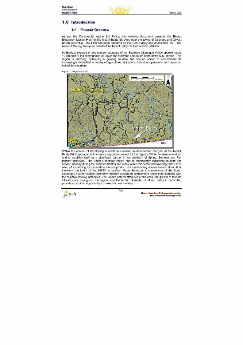
Mt Baldy is situated on the eastern boundary of the Southern Okanagan Valley approximately40 km east of the communities of Oliver and Osoyoos and 25 km north of the U.S. border. Thisregion is currently cultivating a growing tourism and service sector to complement itsincreasingly diversified economy of agriculture, viniculture, industrial operations and resource-based development.
Figure 1-1 Regional Context
Within the context of developing a viable four-season tourism sector, the goal of the MountBaldy Ski Corporation is to create a signature product for the region’s Winter tourism amenities,and to establish itself as a significant partner in the provision of Spring, Summer and Falltourism initiatives. The South Okanagan region has an increasingly successful tourism andservice industry during the summer months, but many within this sector acknowledge that it is inneed of expanding its destination tourism product to include a key winter- season draw. It istherefore the intent of the MBSC to position Mount Baldy as a cornerstone of the SouthOkanagan’s winter season economy, thereby working to complement rather than compete withthe region’s existing amenities. The unique natural attributes of the area, the growth of tourisminfrastructure throughout the region, and the terrain character of Mount Baldy in particular,provide an exciting opportunity to make this goal a reality.
8/12/2019 Mount Baldy
http://slidepdf.com/reader/full/mount-baldy 20/322
Mount BaldyResort Expansion
Master Plan February 2005
Page 2 Brent Harley & Associates Inc.
The Resort Planning Group
As per the Commercial Alpine Skiing Policy1, it is the intent of this document to define both inwritten and graphic form, all relevant and required aspects of this proposed mountain resortdevelopment. Working closely with MBSC, Brent Harley and Associates has prepared thefollowing document to describe the planning process, demonstrate the technical analysis, detailthe ski area plans, and to provide a specific implementation schedule for the proposed resortexpansion.
11..22 TTHHEE PPRROOPPOONNEENNTT
In the Fall of 2002, the three partners of the predecessor Mountain Recreation, LLP (an IdahoLimited Liability Partnership)(“MRLP”) began a review of the possible acquisition of the MountBaldy Ski Area from the Mount Baldy Strata Corporation KAS 1840. On May 2, 2003, MRLPand the Strata formally entered into a letter of intent to purchase the Mt. Baldy Ski Area. OnMay 21, 2003, MRLP and Slotman Enterprises, LTD, Inc. (“Slotman”) formally entered into abinding offer to purchase the remaining privately held land (the “Wapiti Subdivision”)immediately adjacent to the Ski Area. At their June 23, 2003 annual general meeting, the strataowners approved the letter of intent and agreed to enter into a binding purchase and sale
agreement by a vote of 101 to 1. In January 2004, MRLP and its nominees completed thepurchase of the Wapiti Subdivision and in April 2004, the purchase of the Mount Baldy Ski Areawas completed.
Simultaneous to the acquisitions a new corporate structure was completed. All of MRLP’sassets and purchase and sale agreements were transferred to Mountain Investments, Inc., anIdaho Corporation (“MII”) and Winter Recreation, ULC, a Nova Scotia Unlimited LiabilityCorporation (“WRU”). MII is the US Holding Company, which has as its only asset aninvestment in WRU. The three founders, Brent Baker, Brett Sweezy and Robert Boyle are themajority shareholders and directors of MII. WRU is the Canadian Holding Company, whichowns 100% of the two operating companies, Mount Baldy Ski Corporation, (“MBSC”) a BritishColumbia Corporation which operates the ski resort and Mount Baldy Real Estate ULC, a NovaScotia Unlimited Liability Corporation (“MBRU”) which owns and manages all of the real estateat Mt. Baldy.
The three founders and initial Directors of all the Companies referenced above are:
Robert Boyle, Director and V.P. of Finance: Bob brings more than 30 years of accountingand financial experience to this project. Bob is currently the President of Robert Boyle, CPA,PA, a Director of Lifestream Technologies, Inc., and an active investor in real estate located inNorth Idaho (USA). Prior to this partnership, Bob served for 15 years as President of Boyle andStoll, CPAs specializing in taxation and business acquisitions and sales on behalf of a widevariety of clients. Boyle’s background also includes seven years with KPMG Peat Marwick inSouthern California working as an auditor and tax manager.
Brent Baker, Director and V.P. of Real Estate: Brent brings over 20 years of construction,development and real estate investment to the corporation. Brent is currently President andCEO of Baker Construction and Development, Inc., licensed in Idaho, Montana and California.He is the general partner of the Brent and Laura Baker Family Limited Partnership, where heactively manages nearly USD $5 million. Brent has recently been appointed by the Governor ofIdaho to sit on a newly created commission to protect Lake Pend d’Oreille, the largest lake inIdaho.
1 BC Lands, 1995, “Commercial Alpine Skiing Policy”
8/12/2019 Mount Baldy
http://slidepdf.com/reader/full/mount-baldy 21/322
Mount BaldyResort Expansion
Master Plan February 2005
Page 3 Brent Harley & Associates Inc.
The Resort Planning Group
Brett Sweezy, Director and President: Brett brings capital fund raising and formation, investorrelations and over 15 years of financial experience to the corporation. Brett is a Certified Public
Accountant and recently resigned as the Chief Financial Officer of Lifestream Technologies,Inc., a publicly traded medical device design and marketing company. At Lifestream, Brett waspersonally involved in securing nearly USD $20 million of new financing, management of nearly30 employees and Lifestream’s growth from $0 sales to over $5 million annually. Prior to 1999,Brett served as CFO and Treasurer of Secured Interactive Technologies, Inc., and President ofBrett R. Sweezy, CPA, PA, a public accounting firm.
11..33 PPLLAANNNNIINNGG PPRROOCCEESSSS
In the Spring of 2004, Brent Harley and Associates Inc. were retained to create a ResortExpansion Master Plan for Mount Baldy. This work was initiated with a detailed terrain analysisof the proposed Study Area. Using preliminary large-scale topographic mapping (BC TRIM), anassessment of the study area’s potential to support additional alpine ski resort developmentpotential was determined. Subsequently, the range of resort expansion opportunity wascompiled and presented to MBSC. As the results of this analysis proved the technical feasibility
for expansion consistent with the proponent’s anticipated plans for the area, a more detailedproject visioning session was conducted, and more detailed mapping was obtained.
Building upon the opportunities inherent in the local terrain – and anticipating a growing marketdemand for a resort product, somewhat different than the “typical” ski area offering – acomprehensive vision for the new resort was created and detailed conceptual planning wasundertaken. The results of this process provided the foundation for the Master Plan, and willguide the implementation of these plans, both on the mountain and in the base area well intothe future.
11..44 TTHHEE PPRROOJJEECCTT VVIISSIIOONN
Mt. Baldy currently is a “hidden gem” where skiing today can be compared to what it was twentyyears ago: friendly, un-crowded and affordable. The MBSC intends to protect these attributes;to elevate the resort’s infrastructure and ability to support current skier expectations; and totransform Baldy into a profitable enterprise capable of becoming a significant driver of the SouthOkanagan’s regional economy.
AA TTiimmee FFoor r NNeeww RReessoor r tt DDeevveellooppmmeenntt PPr r iinncciipplleess
The mountain resort product in British Columbia has evolved greatly over the last 20 years.Blessed with a vast network of lofty peaks and abundant snow, BC has transformed itself fromrelative obscurity to a primary tourism leader in less than a generation. Today resortcommunities like Whistler, Fernie, Big White and Silver Star are regularly cited as “Best InClass”. Tourism professionals come from all over the world to study how things are done in BC.
Awards, citations, substantial media attention – international success has come rapidly.
Some feel that the once-wildly successful 1980’s resort model is potentially reaching the end ofits conceptual lifespan. Perhaps a new model should be devised to better address the changingsocial practices and new environmental constraints of 21st century life. The MBSC believes thatMt. Baldy provides exactly this type of opportunity.
8/12/2019 Mount Baldy
http://slidepdf.com/reader/full/mount-baldy 22/322
Mount BaldyResort Expansion
Master Plan February 2005
Page 4 Brent Harley & Associates Inc.
The Resort Planning Group
In an effort to complement the existingregional ski-products, to provide thewinter-resort marketplace with a greaterdiversity of product, and to remain true tothe unique Baldy character, MBSCbelieves that there is an opportunity toprogressively redefine their winter-resortproduct. They believe that it is time to getinspired by the sport’s pioneering yearsas a means of stimulating a prosperousand self-sustaining future.
Mountain recreation is all about gettingback in touch with nature. It’s not aboutimposing urban values on a rural sector.Rather, mountain recreation shouldprovide visitors with a respite from theall-too-hectic pace of modern urban life,to provide them with an, ‘escape’. Theintent is to inspire visitors and patrons tovisit these mountain oases time and timeagain.
The intent is to create a successful 21stcentury mountain resort, a resort whoseconceptual foundations are based on itsown unique personality rather than onthe dominant trends of the day.
Consider Mount Baldy’s attributes:
• A high-elevation base area well above the winter freezing level;• A physical environment that features accessible terrain suited to a wide range of users in
a variety of mountain modes (cross-country skiing, snowshoeing, backcountry touringand classic lift serviced boarding and skiing);
• Proximity to a distinctive valley ecosystem (the ‘pocket’ desert);• A relatively gentle winter climate with ample sun and snow;• A rich and inspiring history of local use of the area• Located in the extreme south of the Okanagan – closest resort to the US skier market• Located in one of the fastest growing destination skier markets in BC – the Okanagan.
All these traits suggest that there is an opportunity to craft a gentler, kinder resort model atBaldy than what is currently considered the, “industry norm”. A model where “intimate” stillmeans something real; where “community” is a living, thriving concept, and where the open-space quality of the skier experience is preserved - a model that respects the unique characterof the area’s natural surroundings while acknowledging that there are real limits to development,and growth beyond a threshold point can slowly suffocate the very magic that drew people therein the first place.
While Mt. Baldy’s physical attributes pale in comparison to the grandeur of Whistler/Blackcomb,its unique layout and user-friendly terrain provide a rare opportunity to create a more intimate
The Challenges of the Current Model
“How many customers are too many?” The convergence ofhigh-speed technology and mass-market business practiceshas created a level of on-hill congestion that is increasinglybecoming a liability for some big BC resorts.
“Profit at all costs?” Mountain communities suffer greatly whenthe cost of owning a home becomes unbearable to all but thevery wealthy. So what happens when no one can afford to livewhere they work and play?
“What price haste?” The rapid changes in once-pristinemountain locales have created a growing conflict betweenmountain resort developers and environmentalists. It begs thequestion: when will we start developing the next generation of“green” resorts?
“Business before culture?” Even the once ubiquitous day-lodge(traditionally the heart of any thriving ski area) has been jettisoned in favour of income-producing hillside properties. Sohow do people meet each other anymore?
“Nature -- What nature?” Most resort managers today are sointent on finding corporate dollars to underwrite their on-hillprograms that the slopes and lifts are becoming ugly billboardsfor consumer products. Where did the trees and the forestsgo?
Where is the re-creation in all this? Where is the simple joy ofplaying in the snow in the mountains with people of like mind?Where, finally, are the life-affirming values that once constituted thevery backbone of the ski experience?
- Michel Beaudry, Ski Area Critic and Journalist -
8/12/2019 Mount Baldy
http://slidepdf.com/reader/full/mount-baldy 23/322
Mount BaldyResort Expansion
Master Plan February 2005
Page 5 Brent Harley & Associates Inc.
The Resort Planning Group
and inclusive resort model than has been seen in recent years. In fact, Mt. Baldy’s ability toachieve a truly sustainable future for itself is entirely predicated on a planning process capableof creating a model that complements the existing mountain resort products in the region, whileat the same time highlighting the area’s inimitable qualities. Done correctly, Baldy couldeventually become Canada’s premiere ‘boutique’ resort.
Rather than trying to be all things to all people, the ‘boutique’ resort model sets out to create awell-defined niche product for a specific group of users. Like their retail-shop namesakes,boutique resorts are smaller, more intimate and very knowledgeable about their uniquequalities, designed to absolutely complement the desires and expectations of their clientele.
While North America has been slow to embrace the “boutique resort” concept, the European Alps feature a rich tapestry of models catering to different markets and various demographics.True, the Alps’ mega-resorts (like Les Trois Vallees, Verbier, or St. Anton) dwarf anything North
America could ever produce, but there are also boutique resorts for the very rich (Gstaad orLech for example), boutique resorts catering to the very hip and young (Val Thorens, Saas-Fe,Ischgl), as well as those designed with a more “familial” market in mind (Ste. Foy, La Rosiere,Zinal, Grimentz).
Each has built its market around its own special characteristics. Each lives or dies by howsuccessfully it can attract a specific group of consumers. Interestingly, the so-called “family”resorts get relatively little press in North America (compared to their bigger – and sexier – Alpinemega-cousins), yet their success rate is enviable. For they clearly understand exactly what theirvisitors are looking for. And they don’t have to compromise when delivering the goods!
Given the current socio-economic situation in Western Canada, it would appear that the marketis ready for the introduction of an innovative, new mountain resort model. Moreover, with thechanging demographics in the West, the influx of new residents who don’t necessarily have anyprevious history of snow play, the rise in multi-sport participation among youth, as well as thegrowing clout of the environmental lobby, one could argue that a greener, gentler, moreaccommodating mountain resort – such as the one described below – could become thedefining model for the next few decades.
To that end, the Resort Vision Statement is:
To nurture Mt. Baldy as a special place where the outdoor environment is celebrated,where people are valued, and the timeless spirit of skiing and mountain-play still thrive!
11..55 DDEEVVEELLOOPPMMEENNTT GGOOAALLSS AANNDD OOBBJJEECCTTIIVVEESS
Complementing the Vision Statement the Primary Goal is:
To develop a high-quality all-season mountain resort at Mt. Baldy that offers a uniqueblend of recreational and adventure opportunities including (but not restricted to) lowdensity alpine skiing, snowboarding, Nordic skiing, backcountry touring, mountainbiking, hiking, golfing, horseback riding, birding and a mountain spa/water park.
In support of the Vision and primary goal, the following objectives were established as guidingprinciples in the creation of Mt. Baldy’s Resort Expansion Master Plan:
8/12/2019 Mount Baldy
http://slidepdf.com/reader/full/mount-baldy 24/322
Mount BaldyResort Expansion
Master Plan February 2005
Page 6 Brent Harley & Associates Inc.
The Resort Planning Group
• To build upon BC’s existing reputation for developing great ski resorts, and to provide atop-notch lift-serviced skiing and snowboarding area that is easily accessible to SouthernOkanagan and Central Washington residents.
• To harness the envisioned unique themes and high quality resort development such thatMount Baldy will in turn promote the special nature of the Southern Okanagan region –
thereby attracting tourists and tourism spending from all over the world.• To develop associated and integrated resort residential real estate as a means of
balancing and complementing the resort area development.• To develop a unique base area village, incorporating a retail core, lodge, hotel,
pensions, and overnight accommodations – all designed with an environmentallyresponsible pedestrian orientation.
• To complement and benefit from the existing tourism amenities found in the SouthOkanagan Valley region – principally around the cities of Osoyoos and Oliver.
• To establish an unprecedented working relationship and partnership with the OsoyoosIndian Band – one where economic opportunities can be shared, heritage can becelebrated, and culturally sensitive areas will be respected.
• To establish a resort that will be considered a leading example of environmentally
sensitive and responsible development.• To develop a comprehensive mountain resort that is economically and socially viable,
serves as an important generator for the local and regional economies, and contributesimportant revenue to government taxation bases.
• To execute a carefully constructed phased Implementation Strategy that ensures thatthe development is responsive to changing market trends, and presents a complete andbalanced product at all phases of its development.
11..66 FFIIRRSSTT NNAATTIIOONNSS RREELLAATTIIOONNSSHHIIPP
Excavations in Osoyoos show that the OkanaganIndians have been in the area for many centuries2.
The Osoyoos Indian Band (OIB) claims that theproposed project lies within their traditionalterritory. A project goal is to establish anunprecedented working relationship with FirstNations in the area where economic opportunitiescan be shared, heritage can be celebrated, andculturally sensitive areas will be respected. Theproponent is working diligently at giving meaningto this goal.
The relationship with the OIB is fundamental to the
development of this Expansion Plan.
MBSC, OIB and the province of British Columbiaare currently negotiating a comprehensiveagreement which, if implemented, will allow theproject to proceed through the new All Season Resort Strategy on a fast track basis with OIB‘ssupport.
2 Osoyoos Indian band Development Corporation. http://www.oib.ca/past.htm
The Osoyoos Indian Band, (NK'MIP), was formed onNovember 21, 1877. As part of the Okanagan Nation,
these are a strong, independent and proud people with arich heritage.
The Osoyoos Indian Band has always been progressive.From the early years of ranching, trading and smallfarms the people have continued to change with the
times. Now, huge vineyards sprawl across these lands,businesses are being invited to call this home and the
people have become business oriented. The Bandmanages businesses with annual budgets in excess of
$l4 million dollars and administers its own health, social,educational and municipal services.
The Osoyoos Indian Band Membership is approximately400, with the majority of the Band Members living on the
Osoyoos Indian Reservation. Improvements andmodernization are everywhere. During recent years new
home construction on the reserve has been swift withgrowth matching the rest of the South Okanagan each
year.
- Osoyoos Indian BanDevelopment Corporation Website -
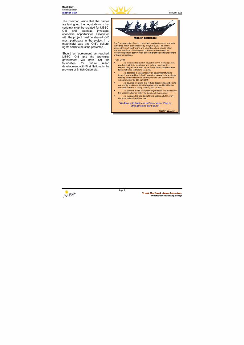
8/12/2019 Mount Baldy
http://slidepdf.com/reader/full/mount-baldy 25/322
Mount BaldyResort Expansion
Master Plan February 2005
Page 7 Brent Harley & Associates Inc.
The Resort Planning Group
The common vision that the partiesare taking into the negotiations is thatcertainty must be created for MBSC,OIB and potential investors,economic opportunities associatedwith the project must be shared, OIBmust participate in the project in ameaningful way and OIB’s culture,rights and title must be protected.
Should an agreement be reached,MSBC, OIB and the provincialgovernment will have set thefoundation for future resortdevelopment with First Nations in theprovince of British Columbia.
MMiissssiioonn SSttaatteemmeenntt The Osoyoos Indian Band is committed to achieving economic self-sufficiency within its businesses by the year 2005. This will beachieved through the training and education of our people whichensures that Pride of Heritage will guide us in developing ourresources optimally both in socio-economic terms and for the benefitof future generations.
Our Goals
• ...to increase the level of education in the following areas:academic, athletic, vocational and cultural - and that thisresponsibility will be shared by the Band, parents and studentsto be motivated to life long learning.
• ...to decrease the dependency on government fundingthrough increased level of self generated income, joint ventures,
leasing, land and resource development so that economicallywe can one day be self sufficient.
• ...to develop programs that reduce dependency and createcommunity involvement that brings back the traditional Indianconcepts of honour, caring, sharing and respect.
• ...to promote a well disciplined organization that will reducethe political influence within the Band and its agencies.
• ...to increase the standard of living opportunity for everyOsoyoos Indian Band Member.
"Working with Business to Preserve our Past byStrengthening our Future”
- OIBDC Website -
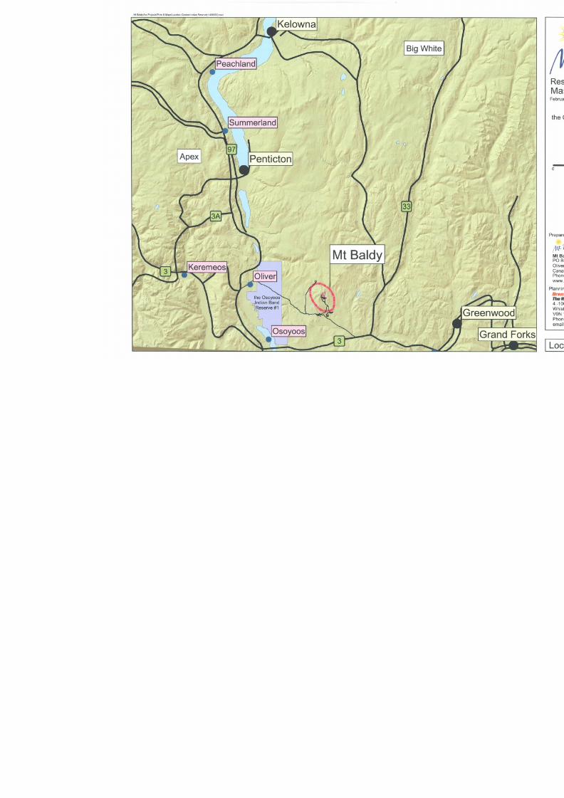
8/12/2019 Mount Baldy
http://slidepdf.com/reader/full/mount-baldy 26/322
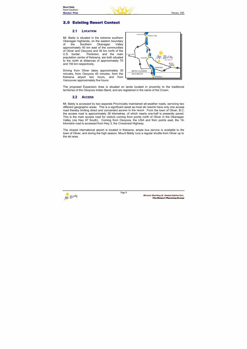
8/12/2019 Mount Baldy
http://slidepdf.com/reader/full/mount-baldy 27/322
Mount BaldyResort Expansion
Master Plan February 2005
Page 9 Brent Harley & Associates Inc.
The Resort Planning Group
22..00 EExxiissttiinngg RReessoor r tt CCoonntteexxtt
22..11 LLOOCCAATTIIOONN
Mt. Baldy is situated in the extreme southernOkanagan highlands, on the eastern boundaryof the Southern Okanagan Valleyapproximately 40 km east of the communitiesof Oliver and Osoyoos and 30 km north of theU.S. border. Penticton, and the mainpopulation centre of Kelowna, are both situatedto the north at distances of approximately 75and 150 km respectively.
Driving from Oliver takes approximately 30minutes, from Osoyoos 45 minutes, from theKelowna airport two hours, and fromVancouver approximately five hours.
The proposed Expansion Area is situated on lands located in proximity to the traditionalterritories of the Osoyoos Indian Band, and are registered in the name of the Crown.
22..22 AACCCCEESSSS
Mt. Baldy is accessed by two separate Provincially maintained all-weather roads, servicing twodifferent geographic areas. This is a significant asset as most ski resorts have only one accessroad thereby limiting direct and convenient access to the resort. From the town of Oliver, B.C.the access road is approximately 36 kilometres, of which nearly one-half is presently paved.This is the main access road for visitors coming from points north of Oliver in the OkanaganValley (via Hwy 97 South). Coming from Osoyoos, the USA and from points east, the 19-kilometre road is accessed from Hwy 3, the Crowsnest Highway.
The closest international airport is located in Kelowna, ample bus service is available to thetown of Oliver, and during the high season, Mount Baldy runs a regular shuttle from Oliver up tothe ski area.
8/12/2019 Mount Baldy
http://slidepdf.com/reader/full/mount-baldy 28/322
Mount BaldyResort Expansion
Master Plan February 2005
Page 10 Brent Harley & Associates Inc.
The Resort Planning Group
22..33 CCUURRRREENNTT RREEGGIIOONNAALL CCOONNTTEEXXTT
Recently, the South Okanagan has been re-discovered by tourists. In 1996, nearly 5 millionvisitors were reported in the South Okanagan. Beginning in 2002, well over $150 million (CND)has been invested in this valley for recreational and tourism purposes, primarily in resort
accommodations (hotels, timeshares and condominium developments). Osoyoos alone growsto nearly 30,000 people during the peak summer months. In addition to enjoying some ofCanada’s best weather, the South Okanagan includes these highlights:
• Canada’s Wine Capital.• One of the fastest growing areas in Canada with a population base estimated at over
50,000.• A booming real estate market with year to date sales in excess of $272,000,000, up 25%
over the previous year to date sales. The average price per unit is up 9%. Recently,over $125 million (CND) has been invested in new residential and commercialdevelopment, with the majority invested within the resort and tourism sector.
• True four-season recreational opportunities
• Home to one of Canada’s newest proposed National Parks (South Okanagan-LowerSimilkameen National Park Reserve Feasibility Study)
• Fast becoming Canada’s premier golf destination, with golfing offered year round(weather permitting). Four golf courses are within a 45-minute drive of Mt. Baldy.
• Canada’s “Palm Springs” attracting winter tourism in addition to its already establishedsummer season.
• A new multi-million dollar shared border-crossing facility just south of Osoyoos, B.C.• Recently received funding to extend and improve the Osoyoos Airport with an overall
goal to make the Osoyoos Airport the regional International Airport.
The following table summarizes the approximate current population that resides within drivetimes of Mt. Baldy:
Table 1. Association with Regional Population Centres
Drive Time FromMt. Baldy
ApproximatePopulation
Includes the Cities of:
1 Hour 100,000Osoyoos, Oliver and Penticton, B.C; Oroville and
Okanagan, USA
2 Hours 250,000Summerland, Peachland, Westbank, Grandforks and
Kelowna, B.C.; Republic, USA
4 to 5 hours 3,000,000Vancouver Metro Area, Vernon, Kamloops, Castlegar
and Nelson, B.C.;Spokane, Colville and Wenatchee, USA
As previously noted, The South Okanagan region has an increasingly successful summer-
season tourism industry, but currently lacks a cornerstone winter-season destination tourismdraw. It is the intent of this submission to demonstrate that Mount Baldy has the potential tobuttress the four-season nature of the regional tourism economy. MBSC feels that the increasedcapacity at Baldy will contribute significantly to the existing South Okanagan tourism corridorbetween Kelowna and Osoyoos. In a good position to capitalize on the substantial regionaldrive-by traffic, this resort will be well situated to capture a growing share of both the summerand winter highway traffic.
In summary, with the proposed expansion of the resort and ski area, Mount Baldy is wellpositioned to play an important role in the regional economy.
8/12/2019 Mount Baldy
http://slidepdf.com/reader/full/mount-baldy 29/322
Mount BaldyResort Expansion
Master Plan February 2005
Page 11 Brent Harley & Associates Inc.
The Resort Planning Group
2.3.1 R R eeg g i i oonnaal l P P l l aannnni i nng g P P ool l i i c c y y
It is the intent of the MBSC to ensure that all proposed developments within this Master Plan areconsistent and supportive of the goals and objectives of the Regional District of KootenayBoundary, the Oliver and District Chamber of Commerce, and the Okanagan Similkameen
Tourism Association.
Additionally, the MBSC is committed to working co-operatively with the Osoyoos Indian Bandand their associated Development Corporation; the Regional District planning staff, Land andWater BC, the Penticton and Boundary Forest District staff, and all associated ProvincialMinistries. The objective is to bring about the necessary amendments to the Regional Plansrequired to permit the envisioned resort expansion development. Further, all efforts will be madeto ensure that all developments associated with this project will coincide with the goals,objectives and development strategies of both the Okanagan-Shushwap, as well as theKootenay-Boundary Land and Resource Management Plans (LRMPs).
Led by the Ministry of Small Business and Economic Development, the Fast Track Program is agovernment initiative designed to facilitate new capital investment in BC. Consistent with thegoals and objectives of this program, the Mount Baldy Expansion has received formaldesignation as a ‘Fast-Tracked’ project. The ‘Fast Track’ designation means Mt. Baldy has beenacknowledged as an economic development priority of the Province of BC and will havetimelines and approvals monitored to ensure timely decision-making throughout the approvaland permitting process.
22..44 HHIISSTTOORRIICC CCOONNTTEEXXTT
The Mt. Baldy Ski area can trace it roots back to the 1940’s when several ski clubs formedwithin the region. After establishing, and subsequently abandoning, several ski area locations,the clubs came together and formed the Borderline Ski Club in 1962. In 1965 a T-Bar was
purchased and installed on Anarchist Mountain, a lower elevation hill located directly offHighway 3 between Rock Creek and Osoyoos. As skiing became more popular in the valley itsoon became evident that the present ski area was not suitable for expansion. In 1968, Mt.Baldy Recreations Inc. purchased the T-Bar and moved the lift to its present location onMcKinney Mountain, a site that offered abundant snow and expanded terrain. During this sameperiod a lodge was built and the first cabin lots were offered at $1,000.
In 1970 a used T-bar was installed on Mt. Baldy at the site of the present double chair lift. Withthe addition of the second lift onto Mt. Baldy and the associated ski area expansion, the ski areaenjoyed steady growth until 1975, when a series of financial setbacks occurred from which Mt.Baldy Recreation, Inc. never fully recovered. At this time competition from other regional skiareas, notably Big White and Silver Star, increased, severely impacting the annual skier visitsexperienced at Mt. Baldy. During the 77/78 ski season, Mt. Baldy recorded its all time highannual ski visitation of nearly 45,000 skiers. Cabin development continued to increase withcabin lots appreciating to $3,500.
The ski area continued to operate “as is” with no new improvements until the double chair wasinstalled to replace the Baldy T-bar in 1999. At this point the ski area had changed ownershipseveral times, eventually being acquired by the Mt. Baldy Strata Corporation in 1992. TheStrata, a not-for-profit corporation, is made up of 102 lot owners of the Mt. Baldy Village (theStrata contains a total of 135 lots). In 2001, the Strata put the ski area up for sale, determiningthat their present ownership structure would not allow them to capitalize needed infrastructurechanges. Finally, the ski area was acquired by MBSC in April, 2004
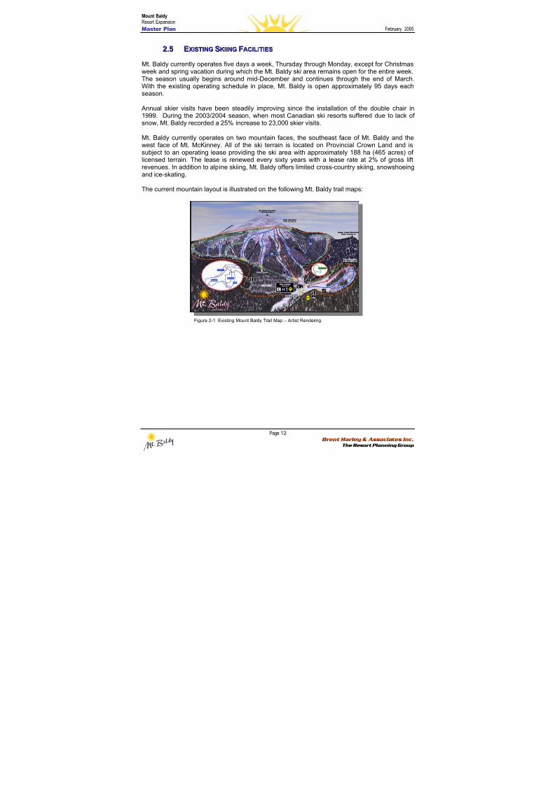
8/12/2019 Mount Baldy
http://slidepdf.com/reader/full/mount-baldy 30/322
Mount BaldyResort Expansion
Master Plan February 2005
Page 12 Brent Harley & Associates Inc.
The Resort Planning Group
22..55 EEXXIISSTTIINNGG SSKKIIIINNGG FFAACCIILLIITTIIEESS
Mt. Baldy currently operates five days a week, Thursday through Monday, except for Christmasweek and spring vacation during which the Mt. Baldy ski area remains open for the entire week.The season usually begins around mid-December and continues through the end of March.
With the existing operating schedule in place, Mt. Baldy is open approximately 95 days eachseason.
Annual skier visits have been steadily improving since the installation of the double chair in1999. During the 2003/2004 season, when most Canadian ski resorts suffered due to lack ofsnow, Mt. Baldy recorded a 25% increase to 23,000 skier visits.
Mt. Baldy currently operates on two mountain faces, the southeast face of Mt. Baldy and thewest face of Mt. McKinney. All of the ski terrain is located on Provincial Crown Land and issubject to an operating lease providing the ski area with approximately 188 ha (465 acres) oflicensed terrain. The lease is renewed every sixty years with a lease rate at 2% of gross liftrevenues. In addition to alpine skiing, Mt. Baldy offers limited cross-country skiing, snowshoeing
and ice-skating.
The current mountain layout is illustrated on the following Mt. Baldy trail maps:
Figure 2-1 Existing Mount Baldy Trail Map – Artist Rendering
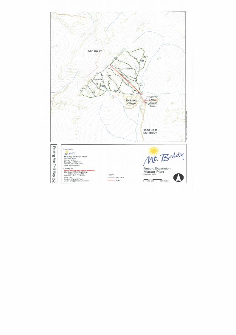
8/12/2019 Mount Baldy
http://slidepdf.com/reader/full/mount-baldy 31/322
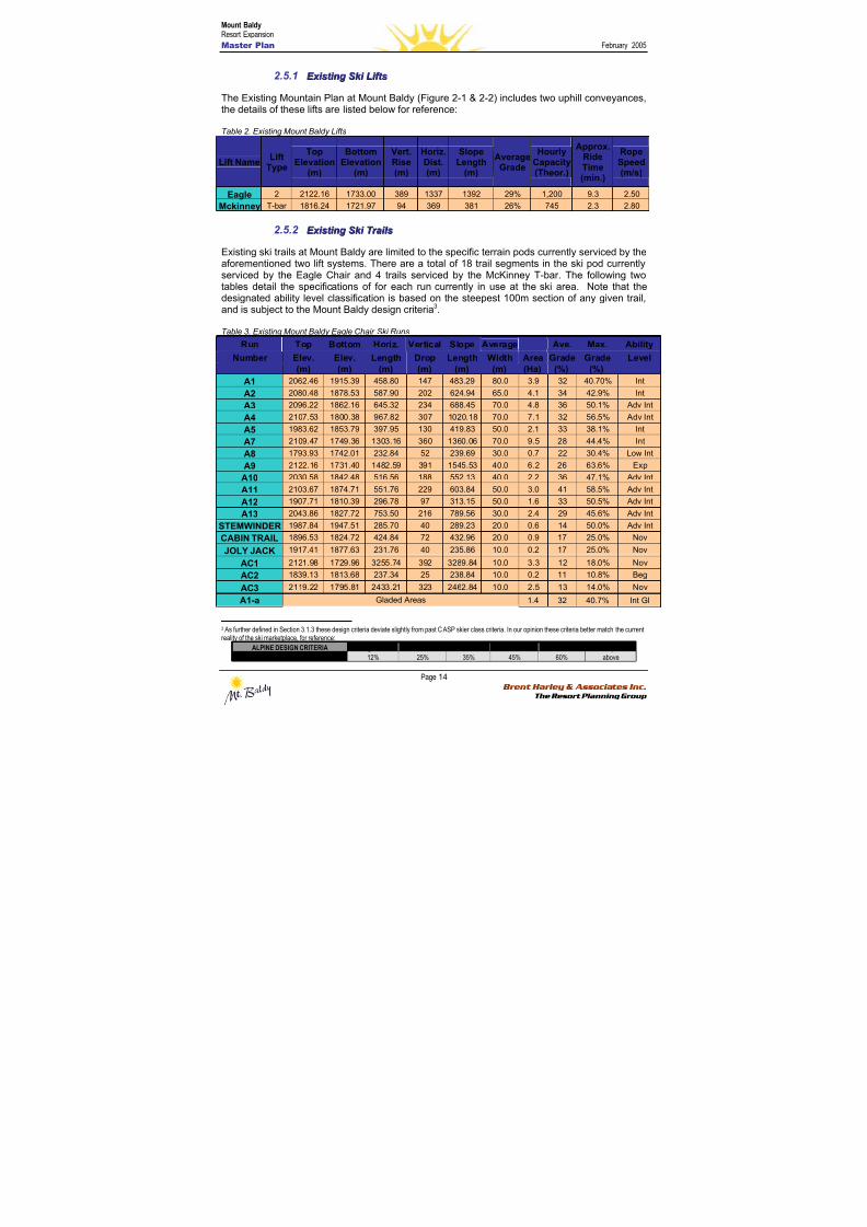
8/12/2019 Mount Baldy
http://slidepdf.com/reader/full/mount-baldy 32/322
Mount BaldyResort Expansion
Master Plan February 2005
Page 14 Brent Harley & Associates Inc.
The Resort Planning Group
2.5.1 E E x x i i sst t i i nng g S S k k i i LLi i f f t t ss
The Existing Mountain Plan at Mount Baldy (Figure 2-1 & 2-2) includes two uphill conveyances,the details of these lifts are listed below for reference:
Table 2. Existing Mount Baldy Lifts
Lift NameLift
Type
TopElevation
(m)
BottomElevation
(m)
Vert.Rise(m)
Horiz.Dist.(m)
SlopeLength
(m)
AverageGrade
HourlyCapacity(Theor.)
Approx.RideTime(min.)
RopeSpeed(m/s)
Eagle 2 2122.16 1733.00 389 1337 1392 29% 1,200 9.3 2.50
Mckinney T-bar 1816.24 1721.97 94 369 381 26% 745 2.3 2.80
2.5.2 E E x x i i sst t i i nng g S S k k i i T T r r aai i l l ss
Existing ski trails at Mount Baldy are limited to the specific terrain pods currently serviced by theaforementioned two lift systems. There are a total of 18 trail segments in the ski pod currently
serviced by the Eagle Chair and 4 trails serviced by the McKinney T-bar. The following twotables detail the specifications of for each run currently in use at the ski area. Note that thedesignated ability level classification is based on the steepest 100m section of any given trail,and is subject to the Mount Baldy design criteria3.
Table 3. Existing Mount Baldy Eagle Chair Ski Runs
Run Top Bottom Horiz. Vertical Slope Average Ave. Max. Ability
Number Elev. Elev. Length Drop Length Width Area Grade Grade Level(m) (m) (m) (m) (m) (m) (Ha) (%) (%)
A1 2062.46 1915.39 458.80 147 483.29 80.0 3.9 32 40.70% Int
A2 2080.48 1878.53 587.90 202 624.94 65.0 4.1 34 42.9% Int
A3 2096.22 1862.16 645.32 234 688.45 70.0 4.8 36 50.1% Adv Int
A4 2107.53 1800.38 967.82 307 1020.18 70.0 7.1 32 56.5% Adv IntA5 1983.62 1853.79 397.95 130 419.83 50.0 2.1 33 38.1% Int
A7 2109.47 1749.36 1303.16 360 1360.06 70.0 9.5 28 44.4% Int
A8 1793.93 1742.01 232.84 52 239.69 30.0 0.7 22 30.4% Low Int
A9 2122.16 1731.40 1482.59 391 1545.53 40.0 6.2 26 63.6% Exp
A10 2030.58 1842.48 516.56 188 552.13 40.0 2.2 36 47.1% Adv Int
A11 2103.67 1874.71 551.76 229 603.84 50.0 3.0 41 58.5% Adv Int
A12 1907.71 1810.39 296.78 97 313.15 50.0 1.6 33 50.5% Adv Int
A13 2043.86 1827.72 753.50 216 789.56 30.0 2.4 29 45.6% Adv Int
STEMWINDER 1987.84 1947.51 285.70 40 289.23 20.0 0.6 14 50.0% Adv Int
CABIN TRAIL 1896.53 1824.72 424.84 72 432.96 20.0 0.9 17 25.0% Nov
JOLY JACK1917.41 1877.63 231.76 40 235.86 10.0 0.2 17 25.0% Nov
AC1 2121.98 1729.96 3255.74 392 3289.84 10.0 3.3 12 18.0% Nov
AC2 1839.13 1813.68 237.34 25 238.84 10.0 0.2 11 10.8% Beg
AC3 2119.22 1795.81 2433.21 323 2462.84 10.0 2.5 13 14.0% Nov
A1-a Gladed Areas 1.4 32 40.7% Int Gl
3 As further defined in Section 3.1.3 these design criteria deviate slightly from past CASP skier class criteria. In our opinion these criteria better match the currentreality of the ski marketplace, for reference:
ALPINE DESIGN CRITERIA Beginner Novice Low Int. Int Adv Int Exp
Maximum Grade 12% 25% 35% 45% 60% above
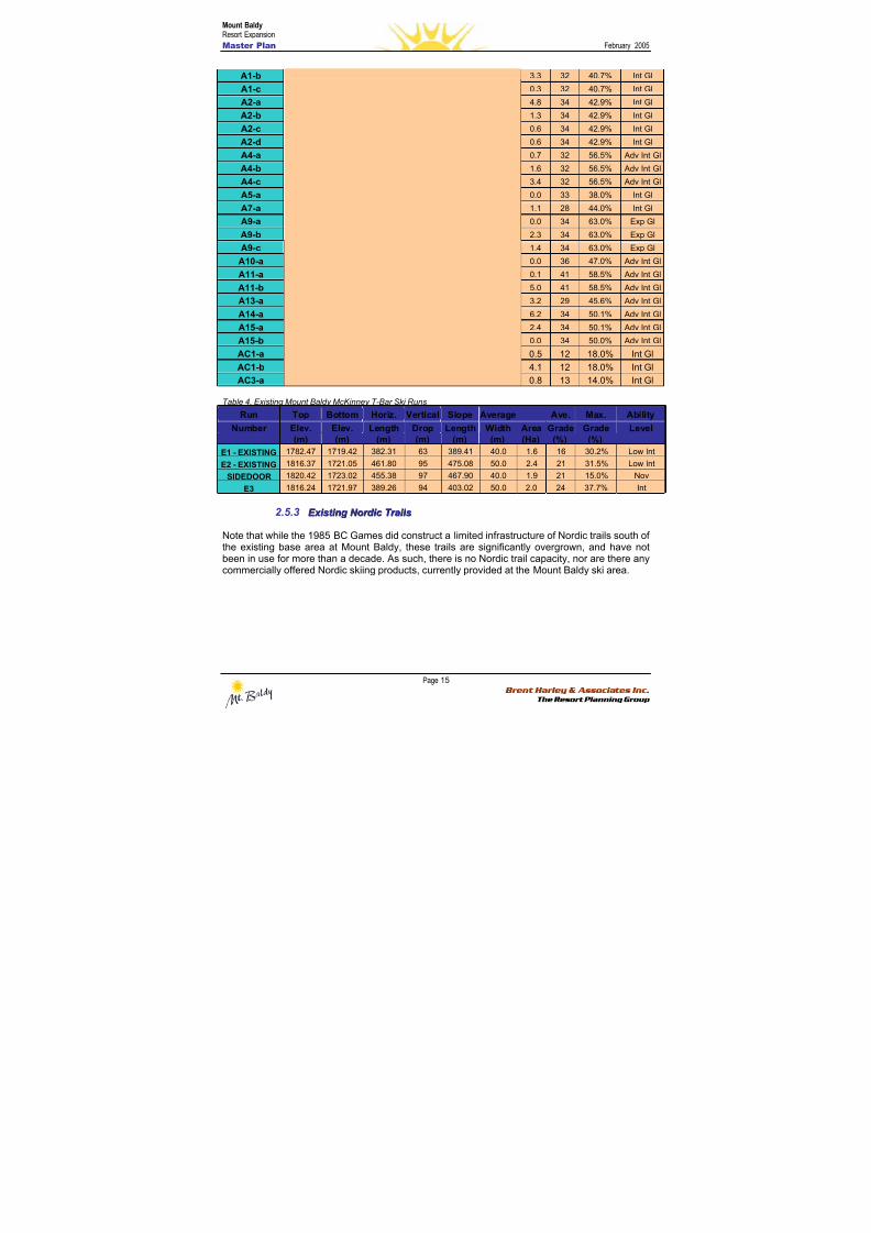
8/12/2019 Mount Baldy
http://slidepdf.com/reader/full/mount-baldy 33/322
Mount BaldyResort Expansion
Master Plan February 2005
Page 15 Brent Harley & Associates Inc.
The Resort Planning Group
A1-b 3.3 32 40.7% Int Gl
A1-c 0.3 32 40.7% Int Gl
A2-a 4.8 34 42.9% Int Gl
A2-b 1.3 34 42.9% Int Gl
A2-c 0.6 34 42.9% Int Gl
A2-d 0.6 34 42.9% Int Gl
A4-a 0.7 32 56.5% Adv Int Gl
A4-b 1.6 32 56.5% Adv Int Gl
A4-c 3.4 32 56.5% Adv Int Gl
A5-a 0.0 33 38.0% Int Gl
A7-a 1.1 28 44.0% Int Gl
A9-a 0.0 34 63.0% Exp Gl
A9-b 2.3 34 63.0% Exp Gl
A9-c 1.4 34 63.0% Exp Gl
A10-a 0.0 36 47.0% Adv Int Gl
A11-a0.1 41 58.5% Adv Int Gl
A11-b 5.0 41 58.5% Adv Int Gl
A13-a 3.2 29 45.6% Adv Int Gl
A14-a 6.2 34 50.1% Adv Int Gl
A15-a 2.4 34 50.1% Adv Int Gl
A15-b 0.0 34 50.0% Adv Int Gl
AC1-a 0.5 12 18.0% Int Gl
AC1-b 4.1 12 18.0% Int Gl
AC3-a 0.8 13 14.0% Int Gl
Table 4. Existing Mount Baldy McKinney T-Bar Ski Runs
Run Top Bottom Horiz. Vertical Slope Average Ave. Max. AbilityNumber Elev. Elev. Length Drop Length Width Area Grade Grade Level
(m) (m) (m) (m) (m) (m) (Ha) (%) (%)
E1 - EXISTING 1782.47 1719.42 382.31 63 389.41 40.0 1.6 16 30.2% Low Int
E2 - EXISTING 1816.37 1721.05 461.80 95 475.08 50.0 2.4 21 31.5% Low Int
SIDEDOOR 1820.42 1723.02 455.38 97 467.90 40.0 1.9 21 15.0% Nov
E3 1816.24 1721.97 389.26 94 403.02 50.0 2.0 24 37.7% Int
2.5.3 E E x x i i sst t i i nng g N N oor r d d i i c c T T r r aai i l l ss
Note that while the 1985 BC Games did construct a limited infrastructure of Nordic trails south ofthe existing base area at Mount Baldy, these trails are significantly overgrown, and have not
been in use for more than a decade. As such, there is no Nordic trail capacity, nor are there anycommercially offered Nordic skiing products, currently provided at the Mount Baldy ski area.
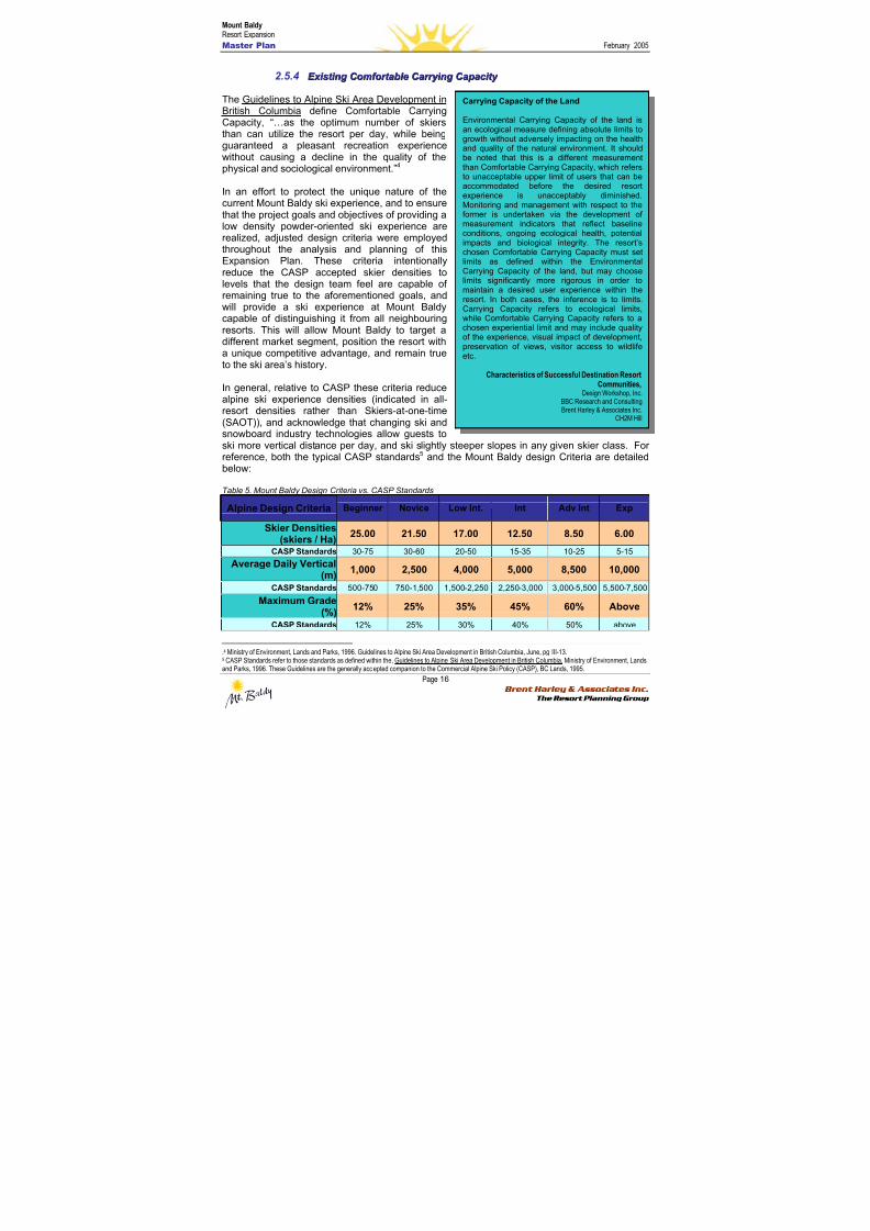
8/12/2019 Mount Baldy
http://slidepdf.com/reader/full/mount-baldy 34/322
Mount BaldyResort Expansion
Master Plan February 2005
Page 16 Brent Harley & Associates Inc.
The Resort Planning Group
2.5.4 E E x x i i sst t i i nng g C C oommf f oor r t t aabbl l ee C C aar r r r y y i i nng g C C aa p paac c i i t t y y
The Guidelines to Alpine Ski Area Development inBritish Columbia define Comfortable CarryingCapacity, “…as the optimum number of skiers
than can utilize the resort per day, while beingguaranteed a pleasant recreation experiencewithout causing a decline in the quality of thephysical and sociological environment.”4
In an effort to protect the unique nature of thecurrent Mount Baldy ski experience, and to ensurethat the project goals and objectives of providing alow density powder-oriented ski experience arerealized, adjusted design criteria were employedthroughout the analysis and planning of thisExpansion Plan. These criteria intentionallyreduce the CASP accepted skier densities tolevels that the design team feel are capable ofremaining true to the aforementioned goals, andwill provide a ski experience at Mount Baldycapable of distinguishing it from all neighbouringresorts. This will allow Mount Baldy to target adifferent market segment, position the resort witha unique competitive advantage, and remain trueto the ski area’s history.
In general, relative to CASP these criteria reducealpine ski experience densities (indicated in all-resort densities rather than Skiers-at-one-time(SAOT)), and acknowledge that changing ski andsnowboard industry technologies allow guests toski more vertical distance per day, and ski slightly steeper slopes in any given skier class. Forreference, both the typical CASP standards5 and the Mount Baldy design Criteria are detailedbelow:
Table 5. Mount Baldy Design Criteria vs. CASP Standards
Alpine Design Criteria Beginner Novice Low Int. Int Adv Int Exp
Skier Densities(skiers / Ha)
25.00 21.50 17.00 12.50 8.50 6.00
CASP Standards 30-75 30-60 20-50 15-35 10-25 5-15
Average Daily Vertical(m)
1,000 2,500 4,000 5,000 8,500 10,000
CASP Standards 500-750 750-1,500 1,500-2,250 2,250-3,000 3,000-5,500 5,500-7,500
Maximum Grade(%)
12% 25% 35% 45% 60% Above
CASP Standards 12% 25% 30% 40% 50% above
.4 Ministry of Environment, Lands and Parks, 1996. Guidelines to Alpine Ski Area Development in British Columbia, June, pg III-13.5 CASP Standards refer to those standards as defined within the, Guidelines to Alpine Ski Area Development in British Columbia, Ministry of Environment, Landsand Parks, 1996. These Guidelines are the generally accepted companion to the Commercial Alpine Ski Policy (CASP), BC Lands, 1995.
Carrying Capacity of the Land
Environmental Carrying Capacity of the land isan ecological measure defining absolute limits to
growth without adversely impacting on the healthand quality of the natural environment. It shouldbe noted that this is a different measurementthan Comfortable Carrying Capacity, which refersto unacceptable upper limit of users that can beaccommodated before the desired resortexperience is unacceptably diminished.Monitoring and management with respect to theformer is undertaken via the development of measurement indicators that reflect baselineconditions, ongoing ecological health, potentialimpacts and biological integrity. The resort’schosen Comfortable Carrying Capacity must setlimits as defined within the EnvironmentalCarrying Capacity of the land, but may choose
limits significantly more rigorous in order tomaintain a desired user experience within theresort. In both cases, the inference is to limits.Carrying Capacity refers to ecological limits,while Comfortable Carrying Capacity refers to achosen experiential limit and may include qualityof the experience, visual impact of development,preservation of views, visitor access to wildlifeetc.
Characteristics of Successful Destination ResortCommunities,
Design Workshop, Inc.BBC Research and ConsultingBrent Harley & Associates Inc.
CH2M Hill
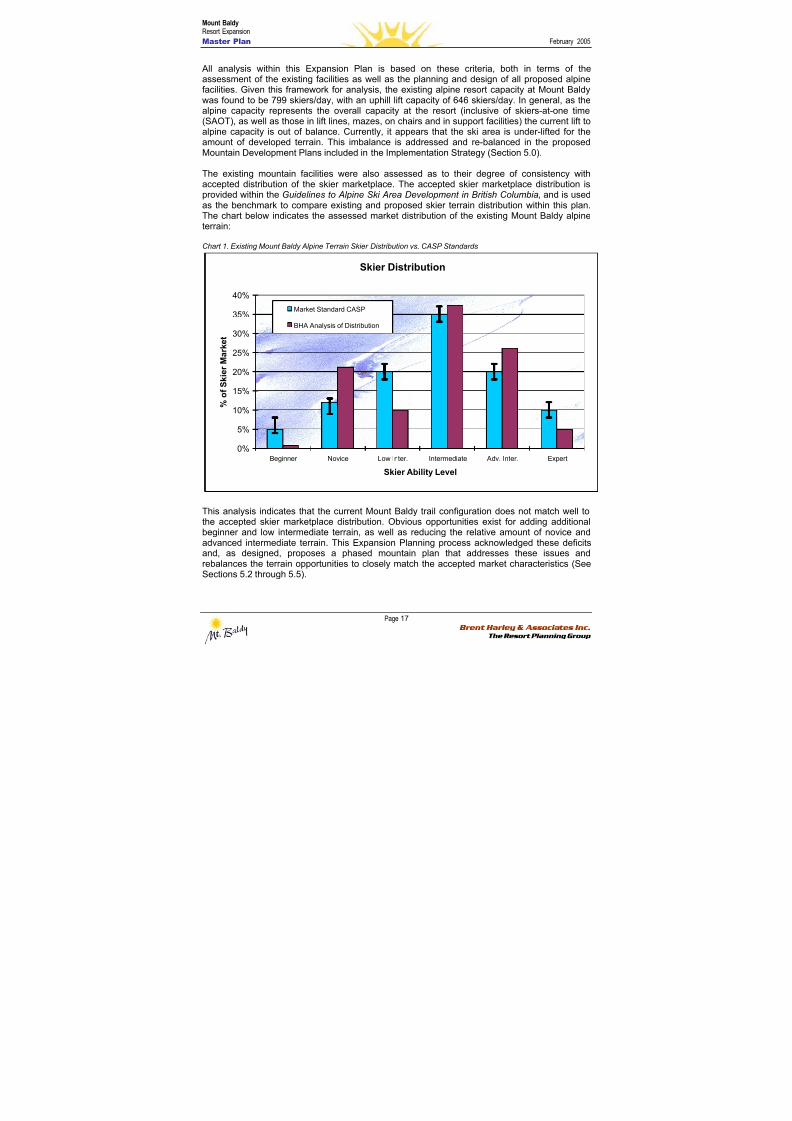
8/12/2019 Mount Baldy
http://slidepdf.com/reader/full/mount-baldy 35/322
Mount BaldyResort Expansion
Master Plan February 2005
Page 17 Brent Harley & Associates Inc.
The Resort Planning Group
All analysis within this Expansion Plan is based on these criteria, both in terms of theassessment of the existing facilities as well as the planning and design of all proposed alpinefacilities. Given this framework for analysis, the existing alpine resort capacity at Mount Baldywas found to be 799 skiers/day, with an uphill lift capacity of 646 skiers/day. In general, as thealpine capacity represents the overall capacity at the resort (inclusive of skiers-at-one time(SAOT), as well as those in lift lines, mazes, on chairs and in support facilities) the current lift toalpine capacity is out of balance. Currently, it appears that the ski area is under-lifted for theamount of developed terrain. This imbalance is addressed and re-balanced in the proposedMountain Development Plans included in the Implementation Strategy (Section 5.0).
The existing mountain facilities were also assessed as to their degree of consistency withaccepted distribution of the skier marketplace. The accepted skier marketplace distribution isprovided within the Guidelines to Alpine Ski Area Development in British Columbia, and is usedas the benchmark to compare existing and proposed skier terrain distribution within this plan.The chart below indicates the assessed market distribution of the existing Mount Baldy alpineterrain:
Chart 1. Existing Mount Baldy Alpine Terrain Skier Distribution vs. CASP Standards
Skier Distribution
0%
5%
10%
15%
20%
25%
30%
35%
40%
Beginner Novice Low Inter. Intermediate Adv. Inter. Expert
Skier Ability Level
% o f S k
i e r M a r k e t
Market Standard CASP
BHA Analysis of Distribution
This analysis indicates that the current Mount Baldy trail configuration does not match well tothe accepted skier marketplace distribution. Obvious opportunities exist for adding additionalbeginner and low intermediate terrain, as well as reducing the relative amount of novice andadvanced intermediate terrain. This Expansion Planning process acknowledged these deficitsand, as designed, proposes a phased mountain plan that addresses these issues andrebalances the terrain opportunities to closely match the accepted market characteristics (SeeSections 5.2 through 5.5).
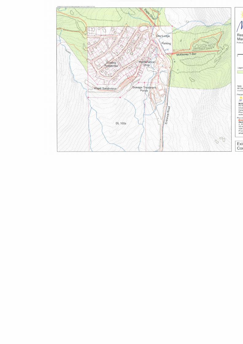
8/12/2019 Mount Baldy
http://slidepdf.com/reader/full/mount-baldy 36/322
8/12/2019 Mount Baldy
http://slidepdf.com/reader/full/mount-baldy 37/322
Mount BaldyResort Expansion
Master Plan February 2005
Page 19 Brent Harley & Associates Inc.
The Resort Planning Group
22..66 EEXXIISSTTIINNGG SSKKIIEERR RREELLAATTEEDD BBUUIILLTT SSPPAACCEE
Located at the base of the ski area is a three-story multi-use Day Lodge housing the ski rentalshop, ski ticket office, ski school office, cafeteria and a fully serviced lounge. The Day Lodge isa 600 square metre frame construction building on a post and pier foundation spanning
McKinney Creek. In addition to the Day Lodge, a series of small structures provide skierservices. In total, there are approximately 760 square metres of built space oriented toaccommodating the needs of the Mt. Baldy visitors. An analysis of this space identifiessignificant shortcomings in terms of space for washrooms, daycare, retail sales andconvenience products, as well as public lockers. Below these buildings are the gravel parkinglot, the maintenance building and a small employee housing building. All buildings are generallyclean and functional but are outdated. The buildings and parking lot are located on over 11acres of deeded land, a rarity for B.C. Ski Resorts.
22..77 EEXXIISSTTIINNGG OOVVEERRNNIIGGHHTT AACCCCOOMMMMOODDAATTIIOONNSS
Currently, the Village of Mt. Baldy is a growing community of approximately 100 privately owned
single-family residences, two condominium complexes consisting of 20 units, and one managedbed and breakfast. The existing village can expand by an additional 30 single-family residences.The current village is located adjacent to the existing base area and ski runs, with someresidences enjoying the ability to ski-in and ski-out. The remaining residences are within aneasy five-minute walk to the ski area.
In December 2004, an affiliated company of MBSC, Mt. Baldy Real Estate, ULC purchased anexisting six-plex condominium immediately adjacent to the ski area base. All of the units withinthis condominium are available for nightly rental and are managed by MBSC. MBSC has alsocontracted to provide overnight rental management services to several homeowners at Mt.Baldy. In total, approximately 40 beds are available for overnight accommodations. MBSC willexpand this service as more on-mountain accommodations become available for short-term
rental.
22..88 EEXXIISSTTIINNGG PPAARRKKIINNGG
The existing gravel parking lot has a maximum capacity of 160 cars. Moreover, the location iswell within an acceptable walking distance to the existing Day Lodge, as well as both the EagleChair and the McKinney T-Bar.
22..99 EEXXIISSTTIINNGG SSTTUUDD Y Y AARREEAA LLAANNDD UUSSEE
Lands within the proposed Expansion Area are currently influenced by both the Okanagan-Shuswap Land and Resource Management Plan (LRMP) and the Kootenay-Boundary LRMP.
Similarly, the proposed CRA is bisected by neighbouring Boundary and Penticton ForestDistricts. Existing land use within the study area include:
• Licence No. 339380 dated June 30, 2002 in favour of Strata Corporation KAS 1840 andassigned unto the Mount Baldy Ski Corporation (Inc. No. 0681126) on April 30, 2004issued for community alpine ski area purposes (including additional tenure area (188 Haof District Lot 2708 Similkameen Division of Yale District more or less ) granted onSeptember 10, 2004).
8/12/2019 Mount Baldy
http://slidepdf.com/reader/full/mount-baldy 38/322
Mount BaldyResort Expansion
Master Plan February 2005
Page 20 Brent Harley & Associates Inc.
The Resort Planning Group
• Right of Way No. 338704 dated January 17, 2002 in favour of Strata Corporation KAS1840 and assigned unto the Mount Baldy Ski Corporation (Inc. No. 0681126) on April 30,2004 issued for ski lift purposes.
• Licence No. 338702 dated September 15, 2002 in favour of Strata Corporation KAS1840 issued for sewer-line purposes.
•
Right of Way No 401992 dated January 28, 1993 in favour of British Columbia• Hydro and Power Authority issued for power-line purposes• License No. 402446 dated February 25, 1996 in favour of Terasen Gas. Inc. issued for
communication site purposes.• License No. 339187 dated March 1, 2003 in favour of VMR Communications Ltd. Issued
for communications site purposes.• License No. 338659 dated January 15, 2002 in favour of Frederic Moore issued for
communication site purposes.• License No. 402406 dated August 15, 1995 in favour of FortisBC BC Inc. for power-line
purposes.• TFL 15 – Weyerhaeuser Cam Leadbeater, Planner, (250) 497-1224
• Forest Licence A18970, Weyerhaeuser Company Ltd., Cam Leadbeater, Planner (250)
497-1224 • Timber Sale Licence A15116, C/0 Al Barclay, Area Forester, Boundary Field Team, BC
Timber Sales Phone: (250) 442-5429 Fax: (250) 442-4317 Site Address: 7290 2ndStreet, Grand Forks Mailing Address: Box 850, Grand Forks, B.C. V0H 1H0
• Mount Baldy Road ROW, Ministry of Highways• McKinney Community Watershed• Trapline Licences TR0801T019, TR0801T018, TR0812T008• One guide outfitter tenure registered to Jim Wiens and another to Melvin Kilback• A Range Tenure registered in the name: Busmann• Placer Tenure registered to: Olympic-04, 392069, P97023• Mineral Tenures registered to: KB#1, 408130, 700356M; KB#5, 408132, 700360M; PAC-
02, 392121, 704511M; PAC-04, 392123, 704509M; PAC-06, 392125, 704507M
Additionally, the proposed Expansion Area is situated on lands located in proximity to thetraditional territories of the Osoyoos Indian Band, and are registered in the name of the Crown.
As such, MBSC is prepared to actively engage First Nations/archaeological consultants to assistin determining the scale and scope of traditional and historic First Nations’ land use in this area.
22..1100 EEXXIISSTTIINNGG DDEEVVEELLOOPPMMEENNTT OOPPPPOORRTTUUNNIITTIIEESS
MBSC is unique in that it presently owns the majority of thedevelopable lands located at the base of the ski area. In fact,MBSC is one of few remaining ski areas in BC that owns the landscentral to the ski area operations, including the lands that housethe day lodge, ski lifts, maintenance facilities and the majority ofthe parking lot. The undeveloped deeded land (approximately eighthectares) located at Mt. Baldy is owned by the MBSC (with theexception of land located in the Strata KAS 1840).
Mt. Baldy Waterworks, Inc., a registered water utility, is owned byan affiliated company controlled by MBSC. Currently the watersystem is in need of expansion and cannot currently serviceadditional connections beyond the needs of the Strata KAS 1840.Mt. Baldy Waterworks, Inc. has $345,000 in escrow specifically set aside to update and expand
Since MBSC’sacquisition, the realestate market at Mt.Baldy has experiencedrenewed enthusiasm.
To date, appreciationon single-family homelots has increased byover 400%. Realestate transactions in2004 have surpassedall previous recordsand interest fromprospective buyerscontinues to escalate.
8/12/2019 Mount Baldy
http://slidepdf.com/reader/full/mount-baldy 39/322
Mount BaldyResort Expansion
Master Plan February 2005
Page 21 Brent Harley & Associates Inc.
The Resort Planning Group
the system in the summer of 2005. The sewer system has approximately 100 availableconnections, all of which are allocated exclusively to Mt. Baldy Real Estate ULC and is notcurrently owned by MBSC, however, MBSC owns the rights to expand and/ or replace thepresent sewer system.
Once the water system is expanded, the 3.6 hectares of land located immediately below thepresent village will be developed into a mix of single-family residences (cabin styledevelopment) and multi-family town homes. MBSC is currently in discussions with a number ofdevelopers who have expressed interest in purchasing this land to develop the property in thesummer of 2005. It is expected that approximately 50 units will be developed on this land.
The remaining 4.4 hectares of private land are located at the base of the ski resort, and housethe core infrastructure needed to operate the ski area. It is expected that this land will be tradedto the Province in order to comply with the current CASP guidelines. Lands received in tradefrom the Province will be used for additional residential and commercial development, asoutlined within this Master Plan.
33..00 MMoouunnttaaiinn AAnnaallyyssiiss
33..11 IINNTTRROODDUUCCTTIIOONN
In the Spring of 2004, an analysis of the Mt. Baldy area was undertaken to assess thedevelopment potential for the expansion of the existing ski resort. Given the defined projectgoals and objectives, a suitable study area was identified (refer to Figure 3-1 to review the exactlocation of the identified study area). Working with 5m contour data, a detailed terrain analysiswas undertaken to initiate and guide the mountain planning process.
The study area was analysed in terms of slope, elevation, aspect and fall-line in order to gain an
understanding of the alpine and Nordic development potential of the physical plant. The mapstudies, combined with available weather data and site knowledge gained from a series of sitevisits, culminated in an understanding of the study area’s capability to physically andenvironmentally support additional four-season recreation activities.
The initial assessments examined the terrain, assessed the slope configurations and identifiedpreliminary fall-line patterns. At this stage multiple concepts were prepared, each definingpreliminary pod identifications as well as potential lift orientations. The centrelines of theidentified skiable pods were analysed to obtain a ‘ball-park’ figure for the terrain developmentpotential. The results of this level of analysis indicated that the physical plant of the mountaincould likely support between 6,000 and 7,000 skiers per day at buildout. Moreover, initialindications were that the mountain would naturally provide an improved skier distribution, one
more capable of matching the accepted market distribution of skier classes.
Given the positive, and to some extent surprising capacity of the mountain to support substantialski terrain expansion, the design team began the process of creating detailed trail orientations,lift configurations and glading opportunities. The following Section highlights the results of theterrain analysis upon which these assessments were founded. The resultant detailed MountainPlan is then fully described in Section 4 – Expansion Master Plan.
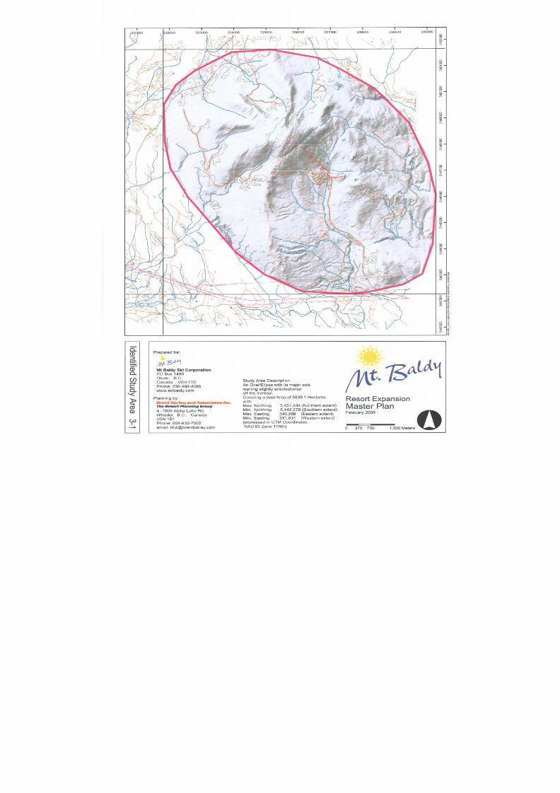
8/12/2019 Mount Baldy
http://slidepdf.com/reader/full/mount-baldy 40/322
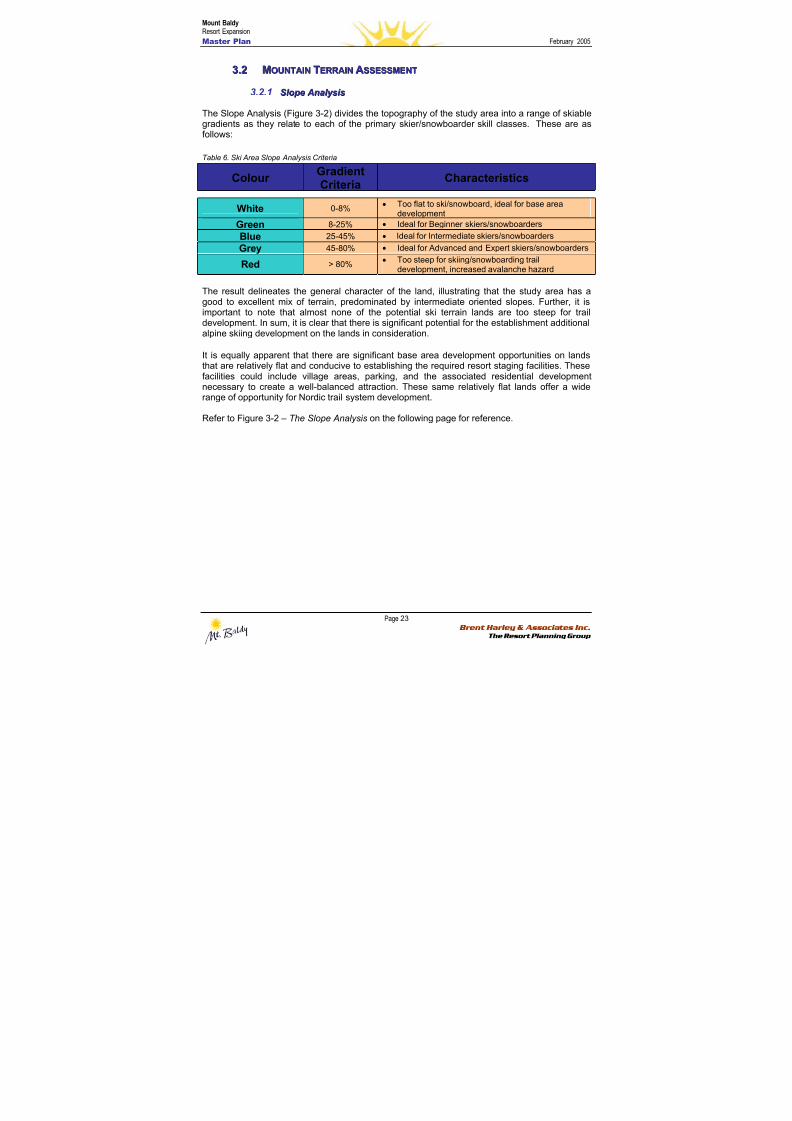
8/12/2019 Mount Baldy
http://slidepdf.com/reader/full/mount-baldy 41/322
Mount BaldyResort Expansion
Master Plan February 2005
Page 23 Brent Harley & Associates Inc.
The Resort Planning Group
33..22 MMOOUUNNTTAAIINN TTEERRRRAAIINN AASSSSEESSSSMMEENNTT
3.2.1 S S l l oo p pee A Annaal l y y ssi i ss
The Slope Analysis (Figure 3-2) divides the topography of the study area into a range of skiable
gradients as they relate to each of the primary skier/snowboarder skill classes. These are asfollows:
Table 6. Ski Area Slope Analysis Criteria
ColourGradientCriteria
Characteristics
White 0-8%• Too flat to ski/snowboard, ideal for base area
development
Green 8-25% • Ideal for Beginner skiers/snowboarders
Blue 25-45% • Ideal for Intermediate skiers/snowboarders
Grey45-80% • Ideal for Advanced and Expert skiers/snowboarders
Red > 80%• Too steep for skiing/snowboarding trail
development, increased avalanche hazard
The result delineates the general character of the land, illustrating that the study area has agood to excellent mix of terrain, predominated by intermediate oriented slopes. Further, it isimportant to note that almost none of the potential ski terrain lands are too steep for traildevelopment. In sum, it is clear that there is significant potential for the establishment additionalalpine skiing development on the lands in consideration.
It is equally apparent that there are significant base area development opportunities on landsthat are relatively flat and conducive to establishing the required resort staging facilities. These
facilities could include village areas, parking, and the associated residential developmentnecessary to create a well-balanced attraction. These same relatively flat lands offer a widerange of opportunity for Nordic trail system development.
Refer to Figure 3-2 – The Slope Analysis on the following page for reference.
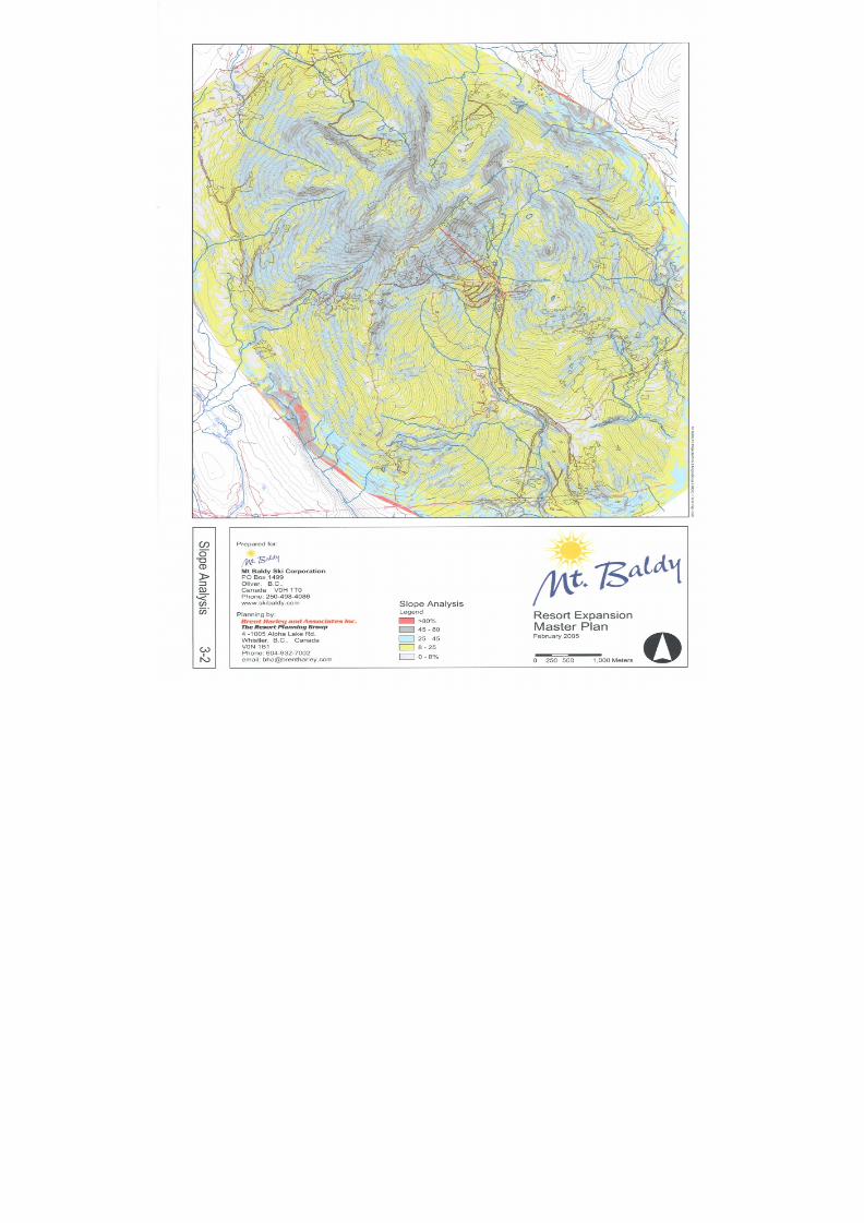
8/12/2019 Mount Baldy
http://slidepdf.com/reader/full/mount-baldy 42/322
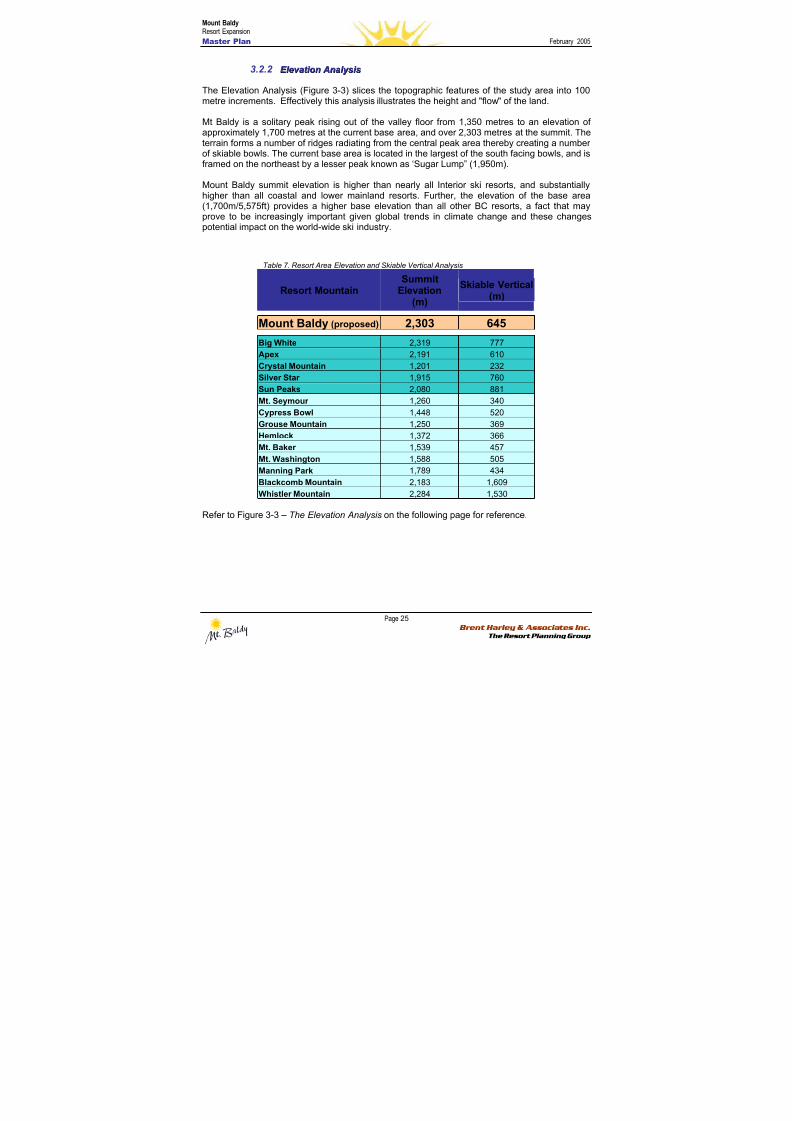
8/12/2019 Mount Baldy
http://slidepdf.com/reader/full/mount-baldy 43/322
Mount BaldyResort Expansion
Master Plan February 2005
Page 25 Brent Harley & Associates Inc.
The Resort Planning Group
3.2.2 E E l l eev v aat t i i oonn A Annaal l y y ssi i ss
The Elevation Analysis (Figure 3-3) slices the topographic features of the study area into 100metre increments. Effectively this analysis illustrates the height and "flow" of the land.
Mt Baldy is a solitary peak rising out of the valley floor from 1,350 metres to an elevation ofapproximately 1,700 metres at the current base area, and over 2,303 metres at the summit. Theterrain forms a number of ridges radiating from the central peak area thereby creating a numberof skiable bowls. The current base area is located in the largest of the south facing bowls, and isframed on the northeast by a lesser peak known as ‘Sugar Lump” (1,950m).
Mount Baldy summit elevation is higher than nearly all Interior ski resorts, and substantiallyhigher than all coastal and lower mainland resorts. Further, the elevation of the base area(1,700m/5,575ft) provides a higher base elevation than all other BC resorts, a fact that mayprove to be increasingly important given global trends in climate change and these changespotential impact on the world-wide ski industry.
Table 7. Resort Area Elevation and Skiable Vertical Analysis
Resort MountainSummit
Elevation(m)
Skiable Vertical(m)
Mount Baldy (proposed) 2,303 645
Big White 2,319 777
Apex 2,191 610
Crystal Mountain 1,201 232
Silver Star 1,915 760Sun Peaks 2,080 881
Mt. Seymour 1,260 340
Cypress Bowl 1,448 520
Grouse Mountain 1,250 369
Hemlock 1,372 366
Mt. Baker 1,539 457
Mt. Washington 1,588 505
Manning Park 1,789 434
Blackcomb Mountain 2,183 1,609
Whistler Mountain 2,284 1,530
Refer to Figure 3-3 – The Elevation Analysis on the following page for reference.
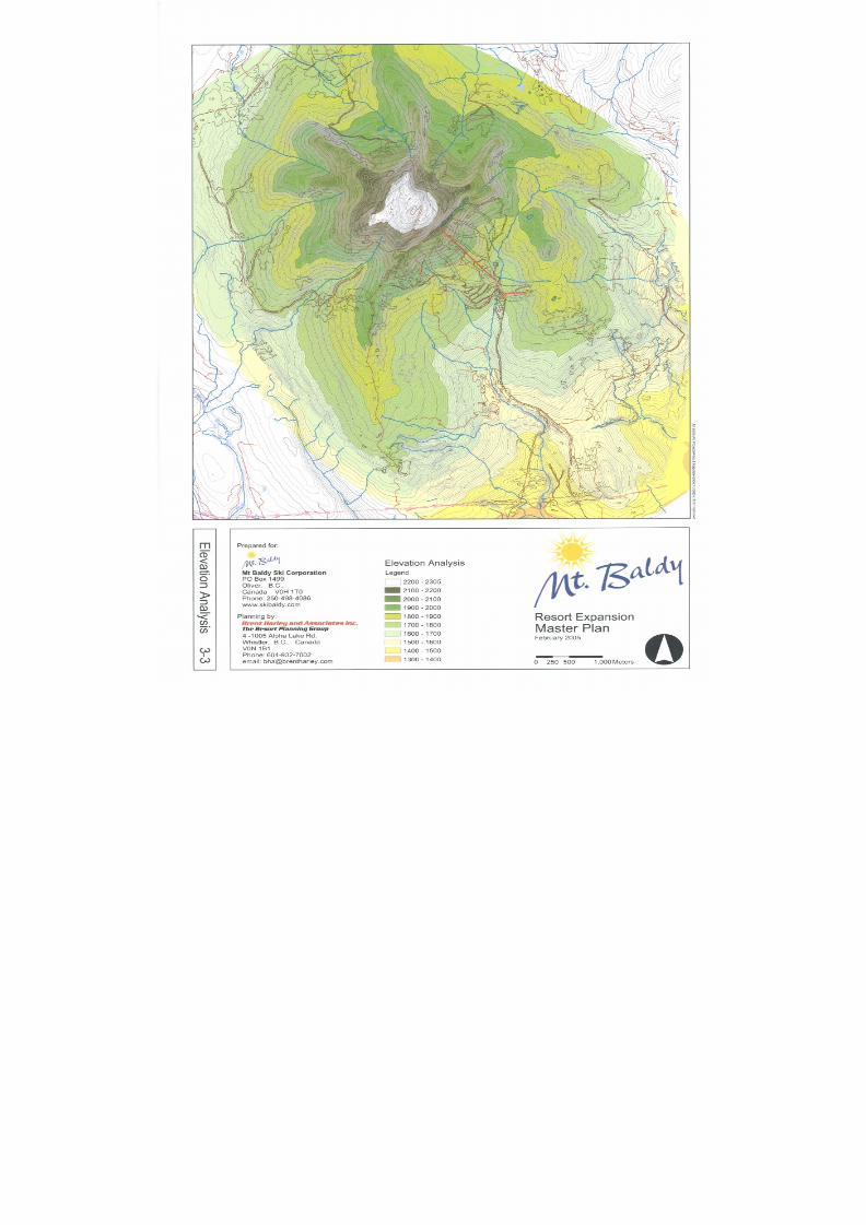
8/12/2019 Mount Baldy
http://slidepdf.com/reader/full/mount-baldy 44/322

8/12/2019 Mount Baldy
http://slidepdf.com/reader/full/mount-baldy 45/322
Mount BaldyResort Expansion
Master Plan February 2005
Page 27 Brent Harley & Associates Inc.
The Resort Planning Group
3.2.3 A Ass p peec c t t A Annaal l y y ssi i ss
The Aspect Analysis (Figure 3-4) involves colour coding the topographic features of the studyarea to illustrate the orientation and geographical exposure with respect to the eight points ofthe compass. Receiving reduced direct sunlight, northern exposures are better suited for snow
retention. These slopes are best for ski trail development, but are less desirable for base areaor residential development. Southern exposures can prove to be problematic for skiing terraindue to reduced snow retention capabilities and a greater probability of solar burn out.Conversely, because these slopes receive partial or full sun exposure, they are more desirablefor base area or residential development.
Ski trails that have a high degree of solar exposure can have the solar burn out minimisedthrough careful design including detailed grading (angling trails away from direct exposure)reduced trail width (maximizing shade from edge vegetation) and erosion control (directing meltwaters away for the trails).
The Mount Baldy area provides good opportunity to capitalize on varied aspect features, as wellas to incorporate designs that build upon these strengths. Further, because of Mt. Baldy’selevation, trails with an orientation to the south will have less snow retention problems thansimilar aspects would experience at lower elevations. The existing base area lands are welllocated on south facing aspects and the associated mountain terrain provides ampleopportunities for substantial ski trail development.
Refer to Figure 3-4 – The Aspect Analysis on the following page for reference.
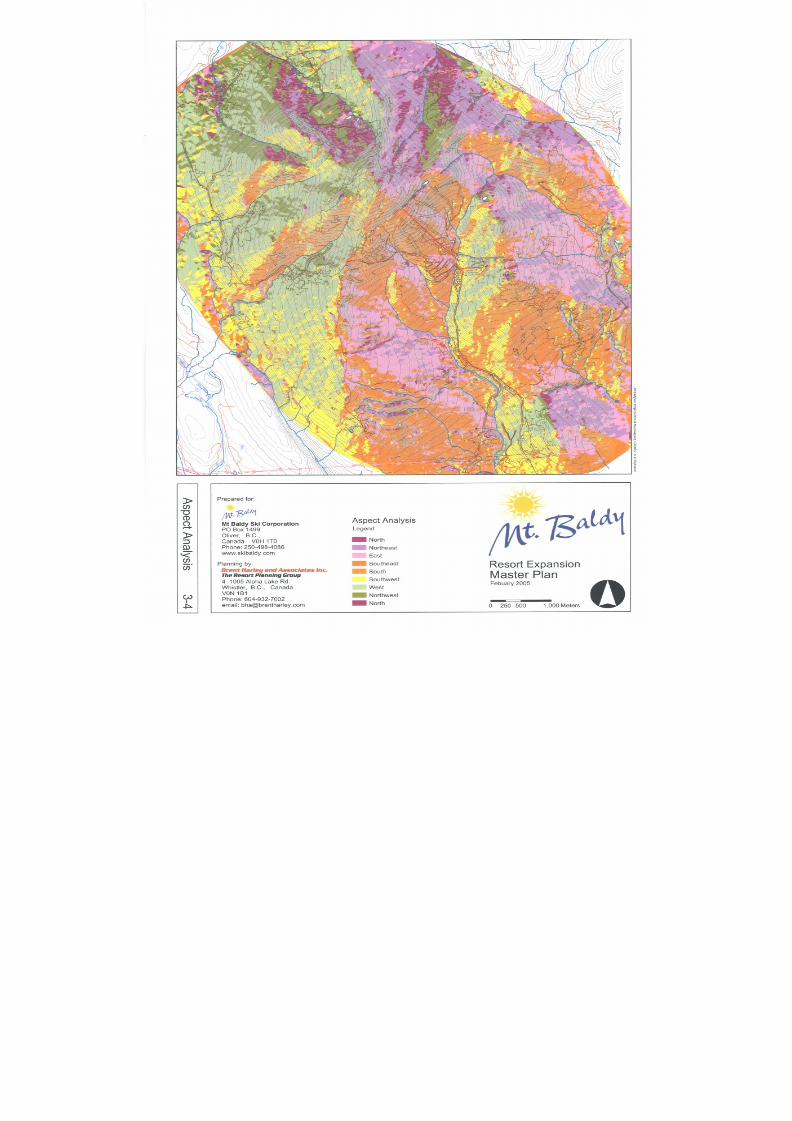
8/12/2019 Mount Baldy
http://slidepdf.com/reader/full/mount-baldy 46/322

8/12/2019 Mount Baldy
http://slidepdf.com/reader/full/mount-baldy 47/322
Mount BaldyResort Expansion
Master Plan February 2005
Page 29 Brent Harley & Associates Inc.
The Resort Planning Group
3.2.4 F F aal l l l - - LLi i nnee A Annaal l y y ssi i ss
A Fall-Line Analysis was completed to assist in the identification of contiguous skiable areas(see Figure 3-5). Effectively, a fall line analysis identifies potential routes that will allow for thenatural flow of skiers and snowboarders from the mountain heights of land to the valley bottoms
in a consistent fashion. This consistency of fall line provides the best recreational skiingexperience while causing the least amount of environmental disruption during trail construction.Based on this analysis, the development of defined planning units (terrain pods) wereestablished, and specific run layouts incorporated into the mountain plan.
The fall line analysis, in conjunction with the elevation and slope analysis of Mt. Baldy illustratethe basic conical shape of the mountain. As such, the fall line pattern generally radiates out fromthe peak of the mountain, defining a series of bowls and ridges. These in turn define specificmountain terrain pods, each generally oriented to the various points of the compass. The singleexception to the conical shape is the Sugar Lump sub-peak, which is joined along asoutheasterly oriented ridge to the peak and separated by a saddle that defines the boundarybetween the McKinney and Wapiti Creek watersheds.
Refer to Figure 3-5 – The Fall-Line Analysis on the following page for reference.
8/12/2019 Mount Baldy
http://slidepdf.com/reader/full/mount-baldy 48/322
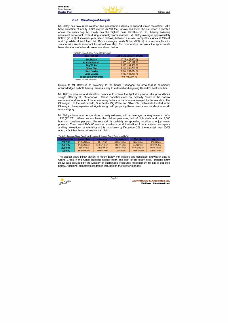
8/12/2019 Mount Baldy
http://slidepdf.com/reader/full/mount-baldy 49/322
Mount BaldyResort Expansion
Master Plan February 2005
Page 31 Brent Harley & Associates Inc.
The Resort Planning Group
3.2.5 C C l l i i mmaat t ool l oog g i i c c aal l A Annaal l y y ssi i ss
Mt. Baldy has favourable weather and geographic qualities to support winter recreation. At abase elevation of nearly 1,723 metres (5,700 feet) above sea level, the ski resort is locatedabove the valley fog. Mt. Baldy has the highest base elevation in BC, thereby ensuring
consistent snow-pack; even during unusually warm seasons. Mt. Baldy averages approximately650cm (21.5 ft) of snow per year, about mid-way between its closet competitors, Apex at 19 feetand Big White at 24.5 feet. Mt. Baldy averages nearly 9 feet (300cm) of snowpack by mid-season, with ample snowpack to ski well into May. For comparative purposes, the approximatebase elevations of other ski areas are shown below:
Table 8. Resort Base Area Comparison
Ski Resort Base Elevation* (m/ft)
Mt. Baldy 1,723 m (5,665 ft)
Apex Mountain 1,575 m (5,197 ft)
Big White 1.508 m (4,950 ft)
Silver Star 1,155 m (3,780 ft)
Sun Peaks 1,255 m (4,117 ft)
Lake Louise 1,622 m (5,450 ft)
Blackcomb/Whistler 675 m (2,214 ft)*Lowest lift base elevation
Unique to Mt. Baldy is its proximity to the South Okanagan, an area that is commonlyacknowledged as both having Canada’s only true desert and enjoying Canada’s best weather.
Mt. Baldy’s location and elevation combine to create the light dry powder skiing conditionssought after by ski aficionados. These conditions are not typically found in the coastalmountains and are one of the contributing factors to the success enjoyed by the resorts in theOkanagan. In the last decade, Sun Peaks, Big White and Silver Star, all resorts located in theOkanagan, have experienced significant growth propelling these resorts into the destination ski
area category.
Mt. Baldy’s base area temperature is rarely extreme, with an average January minimum of –11oC (12.2oF). When one combines the mild temperatures, lack of high winds and over 2,000hours of sunshine per year, the mountain is certainly an appealing location to enjoy winterpursuits. The current 2004/05 season provides a good illustration of the consistent snowpackand high elevation characteristics of this mountain – by December 26th the mountain was 100%open, a fact that few other resorts can claim.
Table 9. Average Base Depth of Snow-pack (Mount Baldy In-House Data)
Ski Season December January February March April2002/03 51.2in/128cm 61.1in/152 63.9in/160cm 72in/180cm 87.9/220cm
2001/0251.9in/130cm 56.8in/142cm 61.2in/153cm 87.9/220cm 99.9in/250cm
2000/01 28.8in/72cm 43.5in/109cm 63.9in/160cm 60.1in/152cm 60in/150/cm
1999/00 56.6in/140cm 63.9in/160cm 72in/180cm 108in/270cm 108in/270cm
The closest snow pillow station to Mount Baldy with reliable and consistent snowpack data isGrano Creek in the Kettle drainage slightly north and east of the study area. Historic snowpillow data provided by the Ministry of Sustainable Resource Management for site is depictedbelow. Additional climatological data is included on the following pages
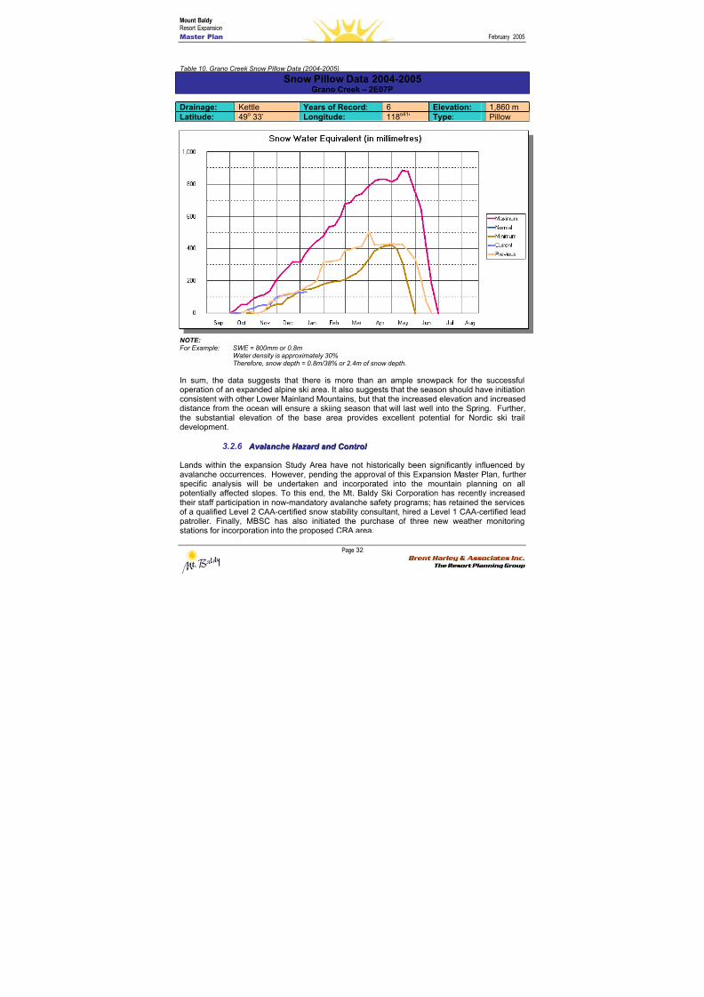
8/12/2019 Mount Baldy
http://slidepdf.com/reader/full/mount-baldy 50/322
Mount BaldyResort Expansion
Master Plan February 2005
Page 32 Brent Harley & Associates Inc.
The Resort Planning Group
Table 10. Grano Creek Snow Pillow Data (2004-2005)
Snow Pillow Data 2004-2005Grano Creek – 2E07P
Drainage: Kettle Years of Record: 6 Elevation: 1,860 mLatitude: 49o 33’ Longitude: 118o41’ Type: Pillow
NOTE:For Example: SWE = 800mm or 0.8m
Water density is approximately 30%Therefore, snow depth = 0.8m/38% or 2.4m of snow depth.
In sum, the data suggests that there is more than an ample snowpack for the successfuloperation of an expanded alpine ski area. It also suggests that the season should have initiationconsistent with other Lower Mainland Mountains, but that the increased elevation and increaseddistance from the ocean will ensure a skiing season that will last well into the Spring. Further,the substantial elevation of the base area provides excellent potential for Nordic ski traildevelopment.
3.2.6 A Av v aal l aannc c hhee H H aaz z aar r d d aannd d C C oonnt t r r ool l
Lands within the expansion Study Area have not historically been significantly influenced byavalanche occurrences. However, pending the approval of this Expansion Master Plan, furtherspecific analysis will be undertaken and incorporated into the mountain planning on allpotentially affected slopes. To this end, the Mt. Baldy Ski Corporation has recently increasedtheir staff participation in now-mandatory avalanche safety programs; has retained the servicesof a qualified Level 2 CAA-certified snow stability consultant, hired a Level 1 CAA-certified leadpatroller. Finally, MBSC has also initiated the purchase of three new weather monitoringstations for incorporation into the proposed CRA area.
8/12/2019 Mount Baldy
http://slidepdf.com/reader/full/mount-baldy 51/322
Mount BaldyResort Expansion
Master Plan February 2005
Page 33 Brent Harley & Associates Inc.
The Resort Planning Group
While it is not anticipated that expanded ski area development will increase the avalanchehazard within the proposed study area, Mount Baldy will ensure that appropriate ski terrainclosures and avalanche control measures are undertaken to minimise the risk to guests andstaff alike. Moreover, as non lift-serviced backcountry areas are integrated into the mountainoperations, appropriate controls, signage, closures and guest supervision protocols will beincorporated to ensure that all potential snow stability risks are appropriately managedthroughout the operating area.
33..33 BBAASSEE AARREEAA TTEERRRRAAIINN AASSSSEESSSSMMEENNTT
Based on the mountain terrain assessment, two base area development focal points becameapparent. The first is the area around the existing Day Lodge (the Upper Base) and the secondlies below the existing residential subdivision area (the Lower Base). Using this as the basiccriteria to define the base lands study area, detailed mapping with one metre contour intervalwas assembled and analysed as to base area development potential.
3.3.1 BBaassee A Ar r eeaa S S l l oo p pee A Annaal l y y ssi i ss
The Slope Analysis of the base lands study area was completed as illustrated in Figure 3-6. Asindicated, the slopes of the lands were categorized based on the physical capability to supportspecific types of development. The grey areas represent areas less than 5% slope. Generally,this land is ideal for all types of built development (base lodge / village development, high,medium and low density residential, parking lots, settlement ponds, golf course etc…). As canbe seen, lands of this classification are in relatively short supply. Again however, the two focalpoints area clearly apparent.
Lands with slopes between 5% and 10% (yellow) that surround the ‘flat’ lands (less than 5%)have significant development potential. With some minimal grading these lands can all be tiedtogether into a contiguous development opportunity. The analysis reinforces the potential in the
two base area focal points. In addition, there are several large topographic benches that havedevelopment potential in areas climbing up the south facing slopes, east of the entrance roadand the lands sloping below the lower base opportunity. Access will be the primary constraint toestablishing development as it relates to these isolated areas. Equally, these lands have veryreal potential for “ski to/ski from” development, a highly desirable quality at a ski resort.
The green coloured slopes represent areas with terrain slopes greater than 10% but less than20%. These lands may be utilized for built development subject to more difficult access issues.While they are generally too steep for base area staging capabilities and high-densitydevelopment, they are still conducive to medium and low-density residential development aswell as limited golf course considerations. As is illustrated, there are a variety of consolidatedareas with this classification.
Slopes between 20% and 30% gradients (indicated by light blue) are lands where mediumdensity development becomes more challenging. The key to entertaining such development isboth vehicular access and the establishment of sufficient off street parking in an economicallyviable fashion. Low-density single family and duplex type development may be applied to theselands with greater ease than the multi-family, medium-density development. The benefits ofdevelopment on these slopes usually include ski to/ski from capabilities, unrestricted views andgood solar access.
The dark blue colour represents areas with slopes between 30% and 40%. This generallyrepresents the maximum limit to low-density development without incurring access and
8/12/2019 Mount Baldy
http://slidepdf.com/reader/full/mount-baldy 52/322
Mount BaldyResort Expansion
Master Plan February 2005
Page 34 Brent Harley & Associates Inc.
The Resort Planning Group
development expenses beyond economic viability. The challenges of developing on theseslopes are often offset with the benefits of big views and excellent solar access.
Finally, pink coloured areas represent slopes greater than 40%. These area should be avoideddue to the difficulties of access and the expense of development unless special circumstancesprevail. As illustrated in the Base Area Slope Analysis, there are no contiguous areas with thisclassification.
In summary, based on slope classifications there appears to be significant large tracts of landscapable of supporting both identified base area focal points, a full spectrum of ‘ski to/ski from’resort residential development, and areas of contiguous lands that, with some grading that willbe able to support at least eighteen holes of golf. Based on this simple criteria there areapproximately 5.4 hectares (13.3 acres) of developable base area lands in relative closeproximity to the upper base, and 5.3 hectares (13.1acres) associated with the Village Base.
3.3.2 BBaassee A Ar r eeaa E E l l eev v aat t i i oonn A Annaal l y y ssi i ss
A base area elevation analysis has been completed as illustrated in Figure 3-7. The areas ofequal elevation have been graphically delineated in order to identify the general ‘flow’ of thebase lands. This is key in establishing an understanding of the pedestrian, biking, and skiinglinkages between the upper and lower bases as well as the adjacent development areas as theyrelate to the mountain development potential. As is readily apparent, the two base areas arevertically separated by approximately 100 metres and horizontally separated by approximately1000 metres. These differences suggest a need to mechanically connect the base areas atsome point in the resort’s development.
3.3.3 BBaassee A Ar r eeaa A Ass p peec c t t aannd d S S ool l aar r A Ac c c c eessss A Annaal l y y ssi i ss
The orientations of the base area lands are primarily to the south. Lands with such an aspectinvariably prove to be very desirable in terms of solar access. In addition, those potentialdevelopment areas on the steepest slopes will afford excellent views of distant lands will play asignificant role in the final placement and orientation of base area facilities and residentialdevelopment.
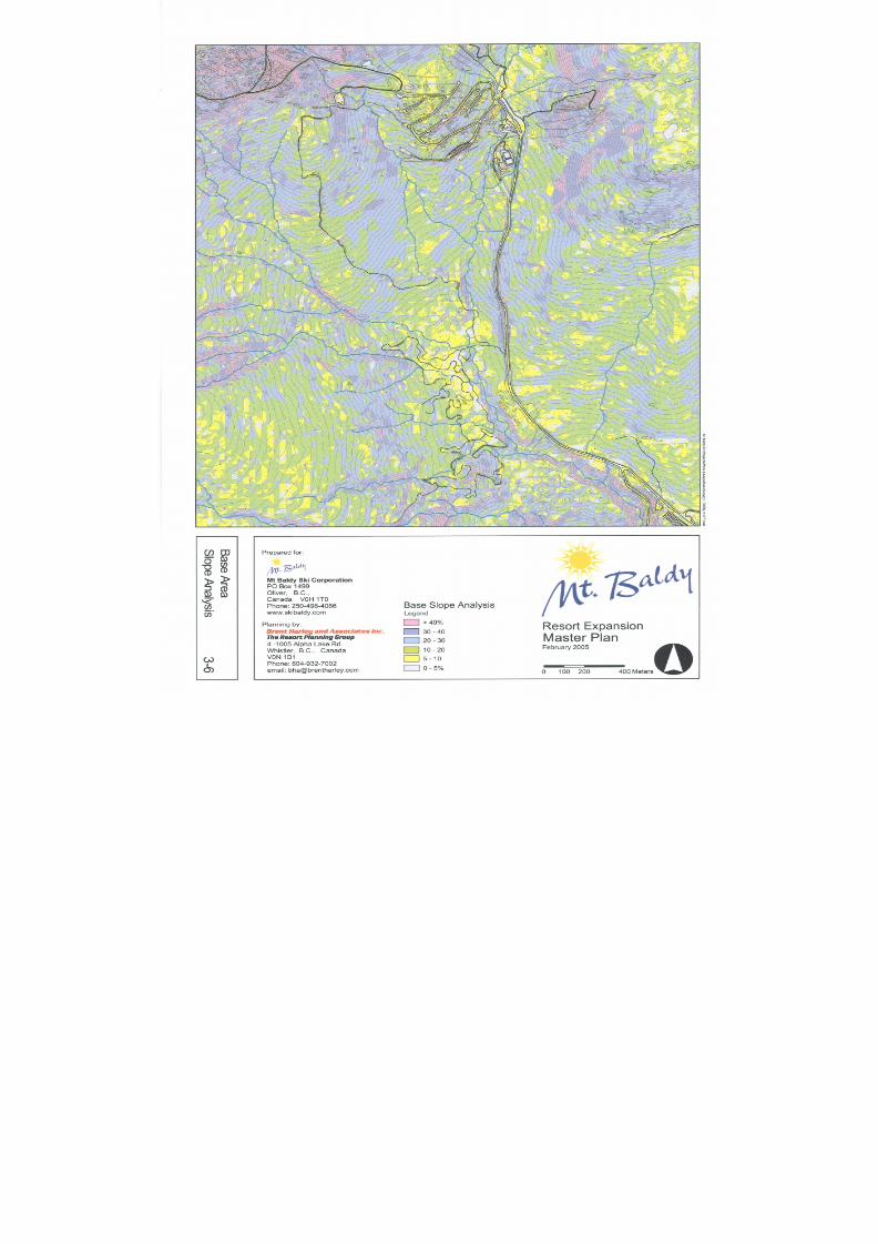
8/12/2019 Mount Baldy
http://slidepdf.com/reader/full/mount-baldy 53/322
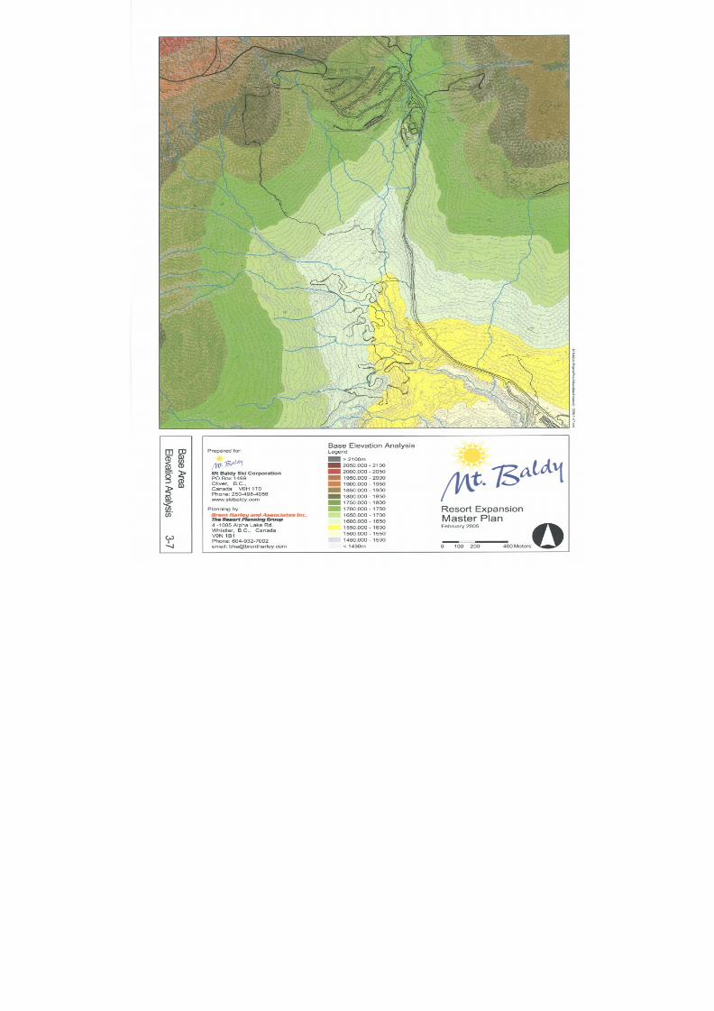
8/12/2019 Mount Baldy
http://slidepdf.com/reader/full/mount-baldy 54/322
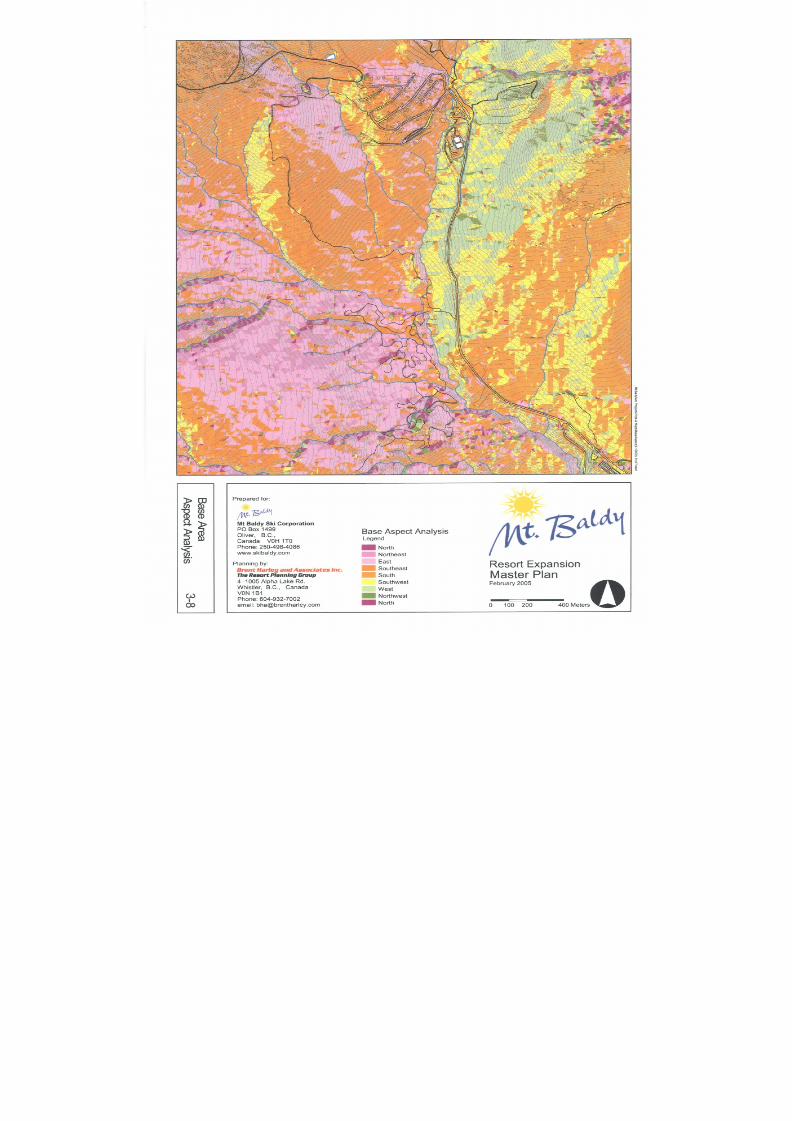
8/12/2019 Mount Baldy
http://slidepdf.com/reader/full/mount-baldy 55/322
8/12/2019 Mount Baldy
http://slidepdf.com/reader/full/mount-baldy 56/322
Mount BaldyResort Expansion
Master Plan February 2005
Page 38 Brent Harley & Associates Inc.
The Resort Planning Group
33..44 EENNVVIIRROONNMMEENNTTAALL CCOONNDDIITTIIOONNSS66
From initial concept to final design, the intent of the Mt. Baldy Ski Corporation has been todevelop a base area plan and associated mountain infrastructure that reflects the type, quality,quantity and sensitivity of the local natural resource values. Prior to commencing the
development of the plan, however, little information regarding fish and wildlife habitats wasavailable to guide planning activities. As such, Snowy River Resources Ltd7. of Summerland,BC was retained to undertake an Environmental Baseline Survey and Management Plan toassess wildlife, riparian, fish habitat and water quality values within the Mt. Baldy Ski HillProposed Expansion Area.
Moreover, on June 25th, 2004, the MBSC and Brent Harley and Associates Inc. met withseveral government agencies including the Ministry of Water, Land and Air Protection, in part, toobtain guidance and advice on managing identified resource values within the study area.
Building on the recommendations and directions provided while at this meeting, and as a meansof further assessing the potential natural resource values, as well as to develop appropriate
recommendations for incorporation into the Master Plan, the MBSC sought additional guidanceand advice of the Registered Professional Biologist team at Snowy River Resources. The scopeof the services provided by the biologists included:
• an assessment of applicable legislation including the Wildlife Act , Migratory BirdsRegulations, Water Act , Fisheries Act , Species at Risk Act , as well as the Forest andRange Practices Act ;
• an assessment of relevant strategic plans, including the Okanagan-Shuswap andKootenay Boundary LRMPs;
• an assessment and incorporation of other related legislative policy initiatives that maynot legally apply to this LWBC application but have components that warrant further
consideration and incorporation. This initiatives include Ungulate Winter Range, theIdentified Wildlife Management Strategy and the Old Growth Management Strategy;
• an assessment of resource information databases maintained by government as well aslocal forest licencees;
• communication with MSRM Planners and Species Specialists (CDC), MWLAPBiologists, WLAP Ecosystems Officers and other independent biologists and speciesspecialists;
• completion of a habitat suitability assessment, fish inventory assessment and bearmanagement plan; and,
• consideration and incorporation of published and draft Best Management Practicesauthored by government and industry.
In general, the results of the assessment indicated that the proposed development representsan exceptionally low risk of environmental harm, based on the known distribution of wildlife
6 Large Portions of Section 3.3 have been excerpted with permission from: Wahl, Doug, 2004. “Environmental Management Plan - Wildlife,Riparian, Fish Habitat and Water Quality Values within the Mt. Baldy Ski Hill Proposed Expansion Area”, Snowy River Resources Ltd., Dec.7 Snowy River Resources Ltd. has experience working with a number of government and industry clients including the BC Forest PracticesBoard, MWLAP, MSRM, Canadian Pacific Railway, Ontario Ministry of Natural Resources, Weyerhaeuser Company Ltd.,PriceWaterhouseCoopers LLC as well as the Ministry of Agriculture, Food and Fisheries. The firm principal, Doug Wahl, is a RegisteredProfessional Biologist and a Certified Professional in Erosion and Sediment Control and has substantial experience in the Southern InteriorRegion working on projects ranging from developing caribou habitat protection recommendations for the forest industry to developing riparianarea strategies for the protection of fish habitat and water quality.
8/12/2019 Mount Baldy
http://slidepdf.com/reader/full/mount-baldy 57/322
Mount BaldyResort Expansion
Master Plan February 2005
Page 39 Brent Harley & Associates Inc.
The Resort Planning Group
and fisheries values, as well as actions that have been proposed by the MBSC to protect thosevalues. The full report, including associated methodology, findings and recommendations isincluded as Appendix One, however highlights of the assessment are summarized in thefollowing few sections.
3.4.1 E E c c ool l oog g y y
The proposed study area is located within the North Okanagan Highland Ecosection (NOH) andthe Englemann spruce – subalpine fir (ESSF) and Montane Spruce (MS) biogeoclimatic zones.Much of the proposed development is within the dry, cold Okanagan variant of the Englemannspruce - subalpine fir biogeoclimatic subzone (ESSF dc1). The remaining portion of theproposed development, within the ESSF, is comprised of the Okanagan dry cold Englemannspruce – subalpine fir upper elevation biogeoclimatic subzone (ESSFdcu); and higher elevation(approximately 2,000 m asl) parkland variant (ESSF dcp1) of the ESSF dc1 subzone. The lowerportion of the development area (below 1,600 m asl) lies entirely within the Okanagan dry mildmontane spruce biogeoclimatic subzone (MSdm1).
The study area encompasses the McKinney Community Watershed, which drains into RockCreek and also includes portions of other drainages including Coteay Creek, Gregoire Creek,Underdown Creek, McIntyre Creek, Wapiti Creek and Rice Creek.
3.4.2 S S t t r r aat t eeg g i i c c LLaannd d U U ssee P P l l aannss
The Okanagan-Shuswap and Kootenay-Boundary Land and Resource Management Plans(LRMPs) are strategic Crown land use plans that set objectives and specific targets for land useactivities, such as resource extraction (forestry and mining), recreation and range use. Thecontent of the Okanagan-Shuswap and Kootenay-Boundary LRMPs are not legally binding butare generally considered by forest licensees as part of the Forest Development Plansubmission. Where practicable, efforts will be made by the MBSC to conform to the spirit andintent of the plan content. As part of this assessment, the content of the plans were reviewed toidentify resource objectives, development constraints or considerations that may apply withinthe study area. Assistance with the interpretation of plan content was sought from the Ministry ofSustainable Resource Management (MSRM).
33..44..22..11 OOKKAANNAAGGAANN--SSHHUUSSWWAAPP LLRRMMPP
The proposed study area is located on the eastern edge of the OSLRMP boundary. Theboundary follows the height of land of Mt. Baldy but excludes any part of the Rock Creekwatershed. There are no specific objectives, Resource Management Zones or other biodiversityvalues identified in the OSLRMP that may have affect within the study area.
33..44..22..22 KKOOOOTTEENNAA Y Y--BBOOUUNNDDAARR Y Y LLRRMMPP
This LRMP boundary includes the entire proposed CRA including the base area with theexception of Mt. Baldy, which lies partially within the OSLRMP boundary. The proposed CRA isconsistent with resource management direction specified within the Kootenay-Boundary HigherLevel Order (2002) and the Kootenay-Boundary LRMP Implementation Strategy (1997)8.
8 Source: http://srmwww.gov.bc.ca/kor/rmd/kblup/toc.htm.
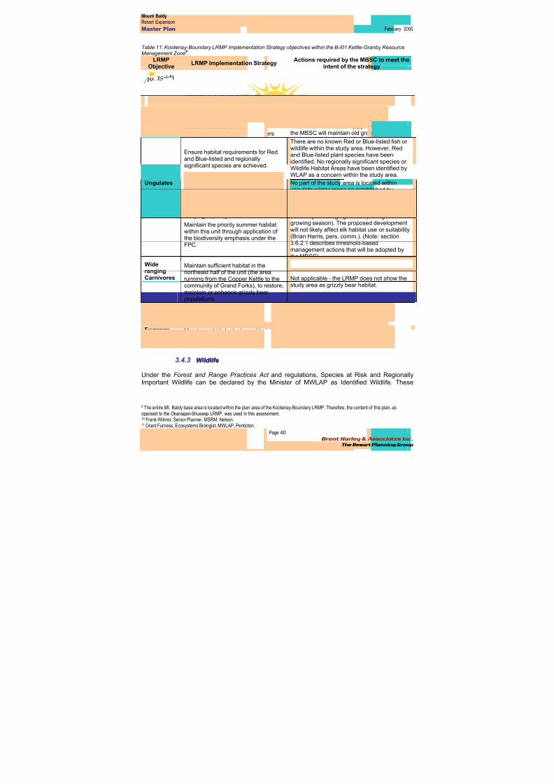
8/12/2019 Mount Baldy
http://slidepdf.com/reader/full/mount-baldy 58/322
Mount BaldyResort Expansion
Master Plan February 2005
Page 40 Brent Harley & Associates Inc.
The Resort Planning Group
Table 11: Kootenay-Boundary LRMP Implementation Strategy objectives within the B-I01 Kettle-Granby ResourceManagement Zone
9.
LRMPObjective
LRMP Implementation StrategyActions required by the MBSC to meet the
intent of the strategy
GeneralBiodiversity
Retain forest and grassland ecologicalelements and processes, including
species richness, distribution anddiversity at a moderate to basicstewardship level.
Based on the results of this environmentalassessment, it is the opinion of the undersigned
that the proposed expansion of Mt. Baldyrepresents an overall low risk of impact tospecies richness, distribution and diversity.
Maintain the regional connectivitycorridors.
The proposed study area does not conflict withconnectivity corridors established by the LRMP.
Retain attributes for old growthdependent species and fur bearers.
With minor modification (approved by MSRM),the MBSC will maintain old growth values.
Ensure habitat requirements for Redand Blue-listed and regionallysignificant species are achieved.
There are no known Red or Blue-listed fish orwildlife within the study area. However, Redand Blue-listed plant species have beenidentified. No regionally significant species orWildlife Habitat Areas have been identified by
WLAP as a concern within the study area.Ungulates
Maintain the abundance of regionallysignificant mule and white-tailed deer,elk and moose within the sustainablecarrying capacity of their habitat.
Maintain the priority summer habitatwithin this unit through application ofthe biodiversity emphasis under theFPC.
No part of the study area is located withinungulate winter range as established bygovernment (Frank Wilmer
10 and Grant
Furness11, pers. comm.). The ESSFdcp1 wasmapped by the undersigned as providing highsuitability elk foraging habitat (during thegrowing season). The proposed developmentwill not likely affect elk habitat use or suitability(Brian Harris, pers. comm.). (Note: section3.6.2.1 describes threshold-basedmanagement actions that will be adopted bythe MBSC).
WiderangingCarnivores
Maintain sufficient habitat in thenortheast half of the unit (the arearunning from the Copper Kettle to thecommunity of Grand Forks), to restore,maintain or enhance grizzly bearpopulations.
Not applicable - the LRMP does not show thestudy area as grizzly bear habitat.
Ensure the existing martenpopulations are maintained orenhanced.
The proposed development will not likely affectmarten populations.
Fisheries Maintain wild fish stocks and habitatfor Rainbow Trout, Mountain Whitefishand Brook Trout
As described in this document, the proposedexpansion will not likely affect fish habitatvalues.
3.4.3 W W i i l l d d l l i i f f ee
Under the Forest and Range Practices Act and regulations, Species at Risk and RegionallyImportant Wildlife can be declared by the Minister of MWLAP as Identified Wildlife. These
9 The entire Mt. Baldy base area is located within the plan area of the Kootenay-Boundary LRMP. Therefore, the content of this plan, asopposed to the Okanagan-Shuswap LRMP, was used in this assessment.10 Frank Wilmer, Senior Planner, MSRM, Nelson.11 Grant Furness, Ecosystems Biologist, MWLAP, Penticton.
8/12/2019 Mount Baldy
http://slidepdf.com/reader/full/mount-baldy 59/322
Mount BaldyResort Expansion
Master Plan February 2005
Page 41 Brent Harley & Associates Inc.
The Resort Planning Group
species can be managed through the establishment of wildlife habitat areas (WHA) as well asother measures.
Wildlife Habitat Areas (WHAs) are mapped areas that are necessary to meet the habitatrequirements of an Identified Wildlife element. WHAs designate critical habitats in whichactivities are managed to limit their impact on the Identified Wildlife element for which the areawas established12.
Within the Okanagan Region of MWLAP, which includes the entire study area boundary, manyWHAs have been approved or are currently proposed. However, there are no WHAs eitherapproved or proposed within the study area boundary (Grant Furness pers. comm.13).
33..44..33..11 UUNNGGUULLAATTEE WWIINNTTEERR RRAANNGGEE
An Ungulate Winter Range (UWR) is legally established under the Forest Practices Code of BC Act or the Forest and Range Practices Act , and is defined as an area that contains habitat thatis necessary to meet the winter habitat requirements of an ungulate species14. The areaencompassed by the study area boundary is not currently designated or planned for designationas Ungulate Winter Range (Grant Furness and Frank Wilmer 15, pers. comm.).
33..44..33..22 RRAARREE AANNDD EENNDDAANNGGEERREEDD SSPPEECCIIEESS
As part of this assessment, the British Columbia Conservation Data Center 16 (CDC) was
consulted to identify information on animals, plants and plant communities at risk (Red17 andBlue-listed18) within the study area.
The CDC indicated that there are no recorded observations for Red or Blue-listed wildlifespecies within or immediately adjacent to the study area.
33..44..33..33 WWIILLDDLLIIFFEE HHAABBIITTAATT SSUUIITTAABBIILLIITT Y Y
The primary data source consulted to derive habitat suitability information for elk, mule deer,lynx, Williamson’s sapsucker and white-headed woodpecker was Terrestrial EcosystemMapping (TEM) with Wildlife Habitat Suitability19 Interpretations completed for WeyerhaeuserTFL 15, Okanagan Falls Division. The document used has three volumes: Volume I: TerrestrialEcosystem & Bioterrrain Mapping with Expanded Legends for Terrestrial Ecosystem Units;Volume II: Wildlife Species Profiles (Accounts20) and Habitat Models; and Volume III: WildlifeHabitat Ratings Tables (Geowest, 2000)21. Wildlife habitat evaluation was completed in TFL 15for the white-headed woodpecker (Picoides albolarvatus), Williamson’s sapsucker (Sphyrapicus
12 MWLAP, 2004. Procedures for Managing Identified Wildlife. Available on-line at
http://wlapwww.gov.bc.ca/wld/documents/identified/IWMS%20Procedures.pdf 13 Grant Furness, Ecosystems Biologist, MWLAP, Penticton.14 http://wlapwww.gov.bc.ca/wld/uwr 15 Frank Wilmer, Senior Planner, MSRM, Nelson16 http://srmwww.gov.bc.ca/cdc/ 17 The CDC defines a Red-listed species as being endangered; facing imminent extirpation or extinction.18 A Blue-listed species as being vulnerable; particularly sensitive to human activities or natural events.19 Habitat suitability is used to identify the current ability of an ecosystem unit to provide a given wildlife species with its life requisites, or theenvironmental conditions needed for cover, food, and space.20 Each species account (profiles) presents the ecology and life requisites for the species, along with assumptions used in assigning habitatsuitability ratings. Preliminary habitat suitability ratings for each species were hypothesized ratings based on the habitat relationships describedin the species profile.21 Available on-line at ftp://ftp.env.gov.bc.ca/dist/wis/tem/warehouse/region_3/okanagan_falls
8/12/2019 Mount Baldy
http://slidepdf.com/reader/full/mount-baldy 60/322
Mount BaldyResort Expansion
Master Plan February 2005
Page 42 Brent Harley & Associates Inc.
The Resort Planning Group
thyroideus), Canada lynx (Lynx canadensis), mule deer (Odocoileus hemionus), and elk(Cervus elaphus). Species accounts, habitat ratings and the accompanying maps depictinghabitat suitability ratings for these five wildlife species were used to complete this assessment.Refer to Appendix One to review the complete methodology.
The following sections summarize the results of TEM Wildlife Interpretations prepared for TFL15 as well as surrogate mapping completed for portions of the study area where TEM had notbeen completed.
33..44..33..44 EELLKK
Elk habitat suitability within and adjacent to the study area in the ESSFdc1 and ESSFdcubiogeoclimatic subzones, is generally rated as low for forage and security/thermal cover in thewinter, and moderate for both forage and security thermal cover during the growing seasons(spring, summer and fall) (Table 12). The dry cold Engelmann Spruce Subalpine Fir (ESSFdc1)biogeoclimatic subzone, occurs at an elevation of 1,600-1,800 m. Dominant vegetation consistsof mixed mature seral stands of lodgepole pine, Engelmann spruce and subalpine fir.
Understorey is dominated by grouseberry, Sitka valerian, five-leaved bramble and trapper’s tea.These plant associations typically provide very limited elk foraging opportunities during thesummer/fall and snow depths restrict winter use.
There is a small portion of alpine sedge, alpine fescue, and herbaceous meadow habitat foundin the upper elevation parkland variant of the ESSFdc1 (Polygon # 1, Figure 3-9). Thesehabitats are found at approximately 2,200m asl and have been rated high for elk foraging in allseasons (Geowest 2000). Alpine sedge, alpine fescue and herbaceous meadow habitat typesprovide excellent opportunities for elk feeding year round. However, it is unlikely that elk use thishabitat in winter months due to the high elevation and the distance to other suitable winterhabitat in the area. The species model for elk in TFL 15 (Geowest 2000) indicates that elk winterhabitat is restricted to elevations less than 1,400m. For this reason we have not mapped thesehabitat associations as high for winter feeding suitability.
There are no known government records of elk use within the study area boundary (Orville Dyerand Brian Harris pers. comm.22) and no elk have been sighted on or near Mt. Baldy by ski hillstaff (Tim Foster, pers. comm.23) The proposed development will not likely affect elk habitat useor suitability (Brian Harris, pers. comm.). Nonetheless, the MBSC supports MWLAPsrecommendation (Brian Harris pers. comm.) that a Qualified Professional should assess elkhabitat use in the ESSFdcp1 once a threshold of >500 person-days/month of use is exceededduring June-October.
22 Orville Dyer and Brian Harris, Wildlife Biologists, MWLAP, Penticton.23 Tim Foster, General Manager, Mt. Baldy Ski Corporation
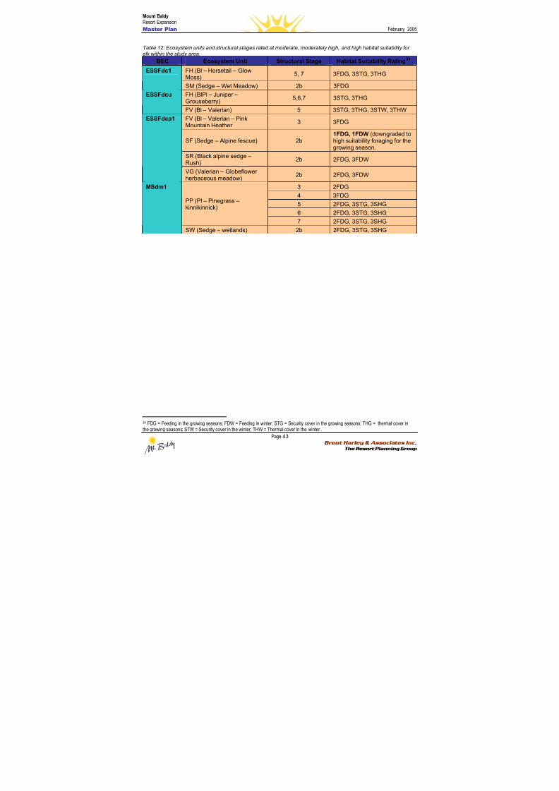
8/12/2019 Mount Baldy
http://slidepdf.com/reader/full/mount-baldy 61/322
Mount BaldyResort Expansion
Master Plan February 2005
Page 43 Brent Harley & Associates Inc.
The Resort Planning Group
Table 12: Ecosystem units and structural stages rated at moderate, moderately high, and high habitat suitability forelk within the study area.
BEC Ecosystem Unit Structural Stage Habitat Suitability Rating24
FH (Bl – Horsetail – GlowMoss)
5, 7 3FDG, 3STG, 3THGESSFdc1
SM (Sedge – Wet Meadow) 2b 3FDG
FH (BlPl – Juniper –Grouseberry)
5,6,7 3STG, 3THGESSFdcu
FV (Bl – Valerian) 5 3STG, 3THG, 3STW, 3THW
FV (Bl – Valerian – PinkMountain Heather
3 3FDG
SF (Sedge – Alpine fescue) 2b1FDG, 1FDW (downgraded tohigh suitability foraging for thegrowing season.
SR (Black alpine sedge –Rush)
2b 2FDG, 3FDW
ESSFdcp1
VG (Valerian – Globeflower
herbaceous meadow)2b 2FDG, 3FDW
3 2FDG
4 3FDG
5 2FDG, 3STG, 3SHG
6 2FDG, 3STG, 3SHG
PP (Pl – Pinegrass –kinnikinnick)
7 2FDG, 3STG, 3SHG
MSdm1
SW (Sedge – wetlands) 2b 2FDG, 3STG, 3SHG
24 FDG = Feeding in the growing seasons; FDW = Feeding in winter; STG = Security cover in the growing seasons; THG = thermal cover inthe growing seasons; STW = Security cover in the winter; THW = Thermal cover in the winter .
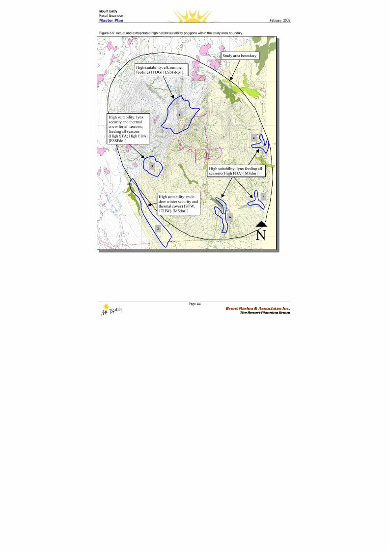
8/12/2019 Mount Baldy
http://slidepdf.com/reader/full/mount-baldy 62/322
Mount BaldyResort Expansion
Master Plan February 2005
Page 44 Brent Harley & Associates Inc.
The Resort Planning Group
Figure 3-9 Actual and extrapolated high habitat suitability polygons within the study area boundary.
High suitability: lynx feeding allseasons (High FDA) [MSdm1].
High suitability: elk summer
feeding (1FDG) [ESSFdcp1].
2
4
1
3
5
6
High suitability: lynx
security and thermal
cover for all seasons;
feeding all seasons(High STA; High FDA)
[ESSFdc1].
Study area boundary
High suitability: mule
deer winter security and
thermal cover (1STW,
1THW) [MSdm1].
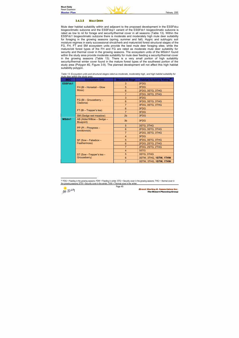
8/12/2019 Mount Baldy
http://slidepdf.com/reader/full/mount-baldy 63/322
Mount BaldyResort Expansion
Master Plan February 2005
Page 45 Brent Harley & Associates Inc.
The Resort Planning Group
33..44..33..55 MMUULLEE DDEEEERR
Mule deer habitat suitability within and adjacent to the proposed development in the ESSFdcubiogeoclimatic subzone and the ESSFdcp1 variant of the ESSFdc1 biogeoclimatic subzone israted as low to nil for forage and security/thermal cover in all seasons (Table 13). Within theESSFdc1 biogeoclimatic subzone there is moderate and moderately high mule deer suitabilityfor foraging in the growing seasons (spring, summer and fall). Hygric and subhygric soilmoisture regimes in early successional shrub/herb and mature/old forest structural stages of theFG, FH, FT and SM ecosystem units provide the best mule deer foraging sites; while themature/old forest types of the FH and FG are rated as moderate mule deer suitability forsecurity and thermal cover in the growing seasons. The ecosystem units of the MSdm1 foundwithin the study area provide moderate suitability for mule deer feeding a security/thermal coverin the growing seasons (Table 13). There is a very small portion of high suitabilitysecurity/thermal winter cover found in the mature forest types of the southwest portion of thestudy area (Polygon #2, Figure 3-9). The planned development will not affect this high habitatsuitability polygon.
Table 13: Ecosystem units and structural stages rated as moderate, moderately high, and high habitat suitability for
mule deer within the study area.BEC Ecosystem Unit Structural Stage Habitat Suitability Rating25
3 2FDG
5 3FDG
6 2FDG, 3STG, 3THG
FH (Bl – Horsetail – GlowMoss)
7 2FDG, 3STG, 3THG
3 3FDG
6 3FDG, 3STG, 3THGFG (Bl – Grouseberry –Cladonia)
7 3FDG, 3STG, 3THG
6 3FDGFT (Bl – Trapper’s tea)
7 3FDG
ESSFdc1
SM (Sedge wet meadow) 2b 3FDG
AB (Alder/Willow – Sedge –Bluejoint)
3b 3FDG
5 3STG, 3THG
6 2FDG, 3STG, 3THGPP (Pl – Pinegrass –kinnikinnick)
7 2FDG, 3STG, 3THG
4 3FDG
5 3FDG, 3STG, 3THG
6 2FDG, 2STG, 2THG
SF (Sxw – Falsebox –Feathermoss)
7 2FDG, 2STG, 2THG
4 3STG
5 3STG, 3THG
6 3STW, 3THG, 1STW, 1THW
MSdm1
ST (Sxw –Trapper’s tea –Grouseberry)
7 3STW, 3THG, 1STW, 1THW
25 FDG = Feeding in the growing seasons; FDW = Feeding in winter; STG = Security cover in the growing seasons; THG = thermal cover inthe growing seasons; STW = Security cover in the winter; THW = Thermal cover in the winter .
8/12/2019 Mount Baldy
http://slidepdf.com/reader/full/mount-baldy 64/322
Mount BaldyResort Expansion
Master Plan February 2005
Page 46 Brent Harley & Associates Inc.
The Resort Planning Group
33..44..33..66 LL Y YNNXX
Lynx habitat suitability within and adjacent to the proposed development in the ESSFdcubiogeoclimatic subzone and the ESSFdcp1 variant of the ESSFdc1 biogeoclimatic subzone israted as low to nil for forage and security/thermal cover in all seasons (Table 14).
Within the ESSFdc1 biogeoclimatic subzone there is moderate habitat suitability for foraging inhygric and subhygric soil moisture regimes in the mature, and old growth forest structural stagesof the FH and FR, ecosystem units, and high suitability for security in the old growth FR units.Young forest successional stage provides high suitability for foraging in the FH units. Theseunits are located in the northern portion of the proposed development area and are all atelevations of 1,750m to 1,900m asl. The model for lynx in TFL 15 (Geowest 2000) states that“lynx in the Okanagan valley vary their elevational use based upon season, utilizing higherelevations during the summer (up to 1,787 m) than during the winter (up to 1,738 m). Thisseasonal pattern of habitat use has been observed and was confirmed by other researchers aswell”. Based on the model, it is unlikely that these units rated as high suitability are beingutilized, and have not been included on the suitability map provided.
High habitat suitability for lynx foraging was identified in the PP, SF and ST ecosystem units ofthe MSdm1. Early seral stages within these ecosystem units provide abundant prey species,and the mix of multi-storied forest canopy and diverse understory provides the forest structuresuitable for security cover. Pole sapling and young forest types in these ecosystem units wereidentified in the riparian habitats in the southern portion of the study area (Polygons 3, 4, 5, & 6,Figure 3-9).
The planned activities will have a low impact on the availability of high suitability lynx habitat(Brian Harris, pers. comm.26). For polygon #3, the habitat will be transected by 2 nordic ski trailswith a total net loss of habitat not exceeding 5%. Polygon #4 and 5 will not be affected byplanned activities. The north end of polygon #6, which also overlaps a portion of a draft OGMA,will also not be affected by planned activities.
26 Brian Harris, Wildlife Biologist, MWLAP, Penticton.
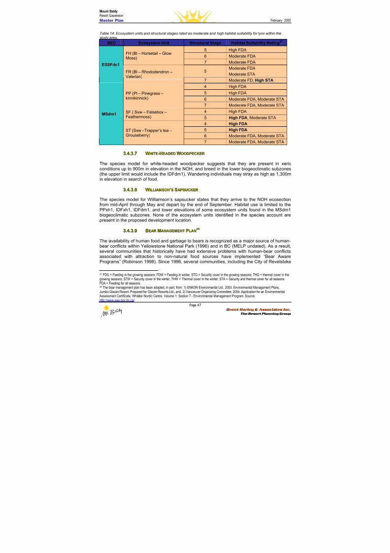
8/12/2019 Mount Baldy
http://slidepdf.com/reader/full/mount-baldy 65/322
Mount BaldyResort Expansion
Master Plan February 2005
Page 47 Brent Harley & Associates Inc.
The Resort Planning Group
Table 14: Ecosystem units and structural stages rated as moderate and high habitat suitability for lynx within thestudy area.
BEC Ecosystem Unit Structural Stage Habitat Suitability Rating27
5 High FDA
6 Moderate FDAFH (Bl – Horsetail – GlowMoss)
7 Moderate FDA
5Moderate FDA
Moderate STA
ESSFdc1
FR (Bl – Rhododendron –Valerian)
7 Moderate FD, High STA
4 High FDA
5 High FDA
6 Moderate FDA, Moderate STA
PP (Pl – Pinegrass –kinnikinnick)
7 Moderate FDA, Moderate STA
4 High FDASF ( Sxw – Falsebox –Feathermoss) 5 High FDA, Moderate STA
4 High FDA5 High FDA
6 Moderate FDA, Moderate STA
MSdm1
ST (Sxw –Trapper’s tea –Grouseberry)
7 Moderate FDA, Moderate STA
33..44..33..77 WWHHIITTEE--HHEEAADDEEDD WWOOOODDPPEECCKKEERR
The species model for white-headed woodpecker suggests that they are present in xericconditions up to 900m in elevation in the NOH, and breed in the lower biogeoclimatic subzones(the upper limit would include the IDFdm1). Wandering individuals may stray as high as 1,300min elevation in search of food.
33..44..33..88 WWIILLLLIIAAMMSSOONN’’SS SSAAPPSSUUCCKKEERR
The species model for Williamson’s sapsucker states that they arrive to the NOH ecosectionfrom mid-April through May and depart by the end of September. Habitat use is limited to thePPxh1, IDFxh1, IDFdm1, and lower elevations of some ecosystem units found in the MSdm1biogeoclimatic subzones. None of the ecosystem units identified in the species account arepresent in the proposed development location.
33..44..33..99 BBEEAARR MMAANNAAGGEEMMEENNTT PPLLAANN2288
The availability of human food and garbage to bears is recognized as a major source of human-bear conflicts within Yellowstone National Park (1996) and in BC (MELP undated). As a result,
several communities that historically have had extensive problems with human-bear conflictsassociated with attraction to non-natural food sources have implemented “Bear AwarePrograms” (Robinson 1998). Since 1996, several communities, including the City of Revelstoke
27 FDG = Feeding in the growing seasons; FDW = Feeding in winter; STG = Security cover in the growing seasons; THG = thermal cover in thegrowing seasons; STW = Security cover in the winter; THW = Thermal cover in the winter; STA = Security and thermal cover for all seasons;FDA = Feeding for all seasons.28 The bear management plan has been adopted, in part, from: 1) ENKON Environmental Ltd., 2003. Environmental Management Plans,Jumbo Glacier Resort. Prepared for Glacier Resorts Ltd.; and, 2) Vancouver Organizing Committee, 2004. Application for an Environmental Assessment Certificate, Whistler Nordic Centre. Volume 1: Section 7 - Environmental Management Program. Source:http://www.eao.gov.bc.ca/.
8/12/2019 Mount Baldy
http://slidepdf.com/reader/full/mount-baldy 66/322
Mount BaldyResort Expansion
Master Plan February 2005
Page 48 Brent Harley & Associates Inc.
The Resort Planning Group
and the Resort Municipality of Whistler have initiated a non-lethal bear management program,which uses the “Bear Aware Program29” approach to reduce the numbers of bear-humanconflicts and also uses deterrents to correct “problem” bear behaviour without destroying theanimals. While the program is still in its infancy, the number of bears destroyed or relocated hasdropped dramatically.
Over the past 5 years, there have been no incidents of bear-human conflicts at the Mt. Baldy skihill (Leslie Cook30, Bob Hamilton31 & Tim Foster 32, pers. comm.). Despite the absence ofrecorded bear-human conflicts, there is an ideal opportunity to initiate a “Bear Aware Program”to minimize the potential for bear-human conflicts to occur. As part of the expansion project, theMt. Baldy Ski Corporation will seek the assistance and cooperation of the Regional District ofKootenay Boundary with the goal of adopting its own “Bear Aware Program”. The program willhave the following objectives:
1. Reduce or eliminate bear deaths and relocations as a result of bears being attracted intothe village by garbage, fruit, compost and other human-generated attractants. Ultimatelythe reduction/elimination of bear deaths would ensure that births exceed deaths;
2. Increase the public’s understanding of the negative implications to bears and humanswhen bears forage in urban areas;
3. Build public support for the objectives of these programs (Robinson 1998); and4. The details of the program outlined below will form part of the long-term management
plan and will be considered as bylaws by the Mt. Baldy Ski Corporation and, where inagreement, the Regional District of Kootenay Boundary. The “Bear Aware Program” forthe Mt. Baldy Ski Hill may include the following mitigation measures:
5. All outdoor trash cans and dumpsters will be of a bear resistant design, and all trashcans will have plastic removable liners to contain odors as much as possible. Plastic canliners will be changed at every pickup to eliminate any odor. Maintenance personnel willensure that the bear-proof trash cans are available where needed.
6. Public areas will be maintained as litter-free as possible within the limits of available staffand budgets.
7. Drive-through inspections for garbage will be performed on a regular basis to determinewhether there are any open containers and/or garbage.
8. Garbage pick-up will be carefully scheduled (preferably later in the day) to assureleaving as little garbage as possible overnight to allow for odor to emanate. If possible,garbage pick-up will be centralized, meaning that single family residences will berequired to drop garbage in local bear-proof containers.
9. All bear-proof containers will be picked up as quickly as possible to minimize the build upof any odors or spillage.
10. Landscaping and maintenance for the Mt. Baldi Ski Hill will avoid the use of fruit trees,compost and other bear attractants.
11. Facility personnel will identify and correct operational and maintenance deficienciesregularly on an on going basis. Inspections will be conducted all year round and comply
with regional standards.12. All long term commercial operators will be given food and garbage management
guidelines.13. Any garbage transfer or detainment areas will be fenced with bear-resistant fencing or
electric fencing. These fences will be repaired and maintained as needed within thelimits of available staff and budgets.
29 Source: http://www.bearaware.bc.ca/.30 Enforcement Clerk, Conservation Officer Service, MWLAP, Penticton.31 Conservation Officer, MWLAP, Penticton.32 Site Manager, Mt. Baldy Ski Corporation
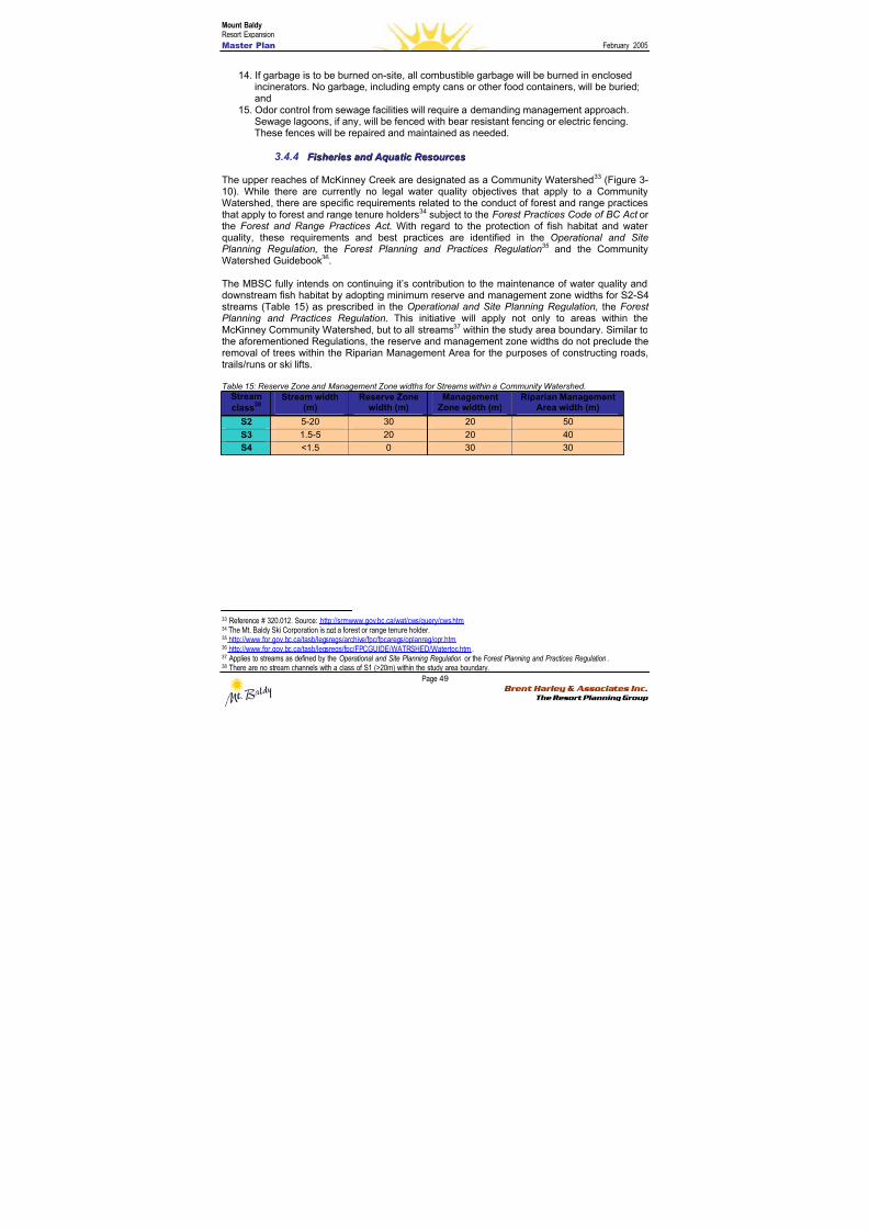
8/12/2019 Mount Baldy
http://slidepdf.com/reader/full/mount-baldy 67/322
Mount BaldyResort Expansion
Master Plan February 2005
Page 49 Brent Harley & Associates Inc.
The Resort Planning Group
14. If garbage is to be burned on-site, all combustible garbage will be burned in enclosedincinerators. No garbage, including empty cans or other food containers, will be buried;and
15. Odor control from sewage facilities will require a demanding management approach.Sewage lagoons, if any, will be fenced with bear resistant fencing or electric fencing.These fences will be repaired and maintained as needed.
3.4.4 F F i i sshheer r i i eess aannd d A Aq q u u aat t i i c c R R eessoou u r r c c eess
The upper reaches of McKinney Creek are designated as a Community Watershed33 (Figure 3-10). While there are currently no legal water quality objectives that apply to a CommunityWatershed, there are specific requirements related to the conduct of forest and range practicesthat apply to forest and range tenure holders34 subject to the Forest Practices Code of BC Act orthe Forest and Range Practices Act . With regard to the protection of fish habitat and waterquality, these requirements and best practices are identified in the Operational and SitePlanning Regulation, the Forest Planning and Practices Regulation35 and the CommunityWatershed Guidebook36.
The MBSC fully intends on continuing it’s contribution to the maintenance of water quality anddownstream fish habitat by adopting minimum reserve and management zone widths for S2-S4streams (Table 15) as prescribed in the Operational and Site Planning Regulation, the ForestPlanning and Practices Regulation. This initiative will apply not only to areas within theMcKinney Community Watershed, but to all streams37 within the study area boundary. Similar tothe aforementioned Regulations, the reserve and management zone widths do not preclude theremoval of trees within the Riparian Management Area for the purposes of constructing roads,trails/runs or ski lifts.
Table 15: Reserve Zone and Management Zone widths for Streams within a Community Watershed.
Stream
class38 Stream width
(m)Reserve Zone
width (m)Management
Zone width (m)Riparian Management
Area width (m)
S2 5-20 30 20 50
S3 1.5-5 20 20 40
S4 <1.5 0 30 30
33 Reference # 320.012. Source: http://srmwww.gov.bc.ca/wat/cws/query/cws.htm 34 The Mt. Baldy Ski Corporation is not a forest or range tenure holder.35 http://www.for.gov.bc.ca/tasb/legsregs/archive/fpc/fpcaregs/oplanreg/opr.htm 36 http://www.for.gov.bc.ca/tasb/legsregs/fpc/FPCGUIDE/WATRSHED/Watertoc.htm.37 Applies to streams as defined by the Operational and Site Planning Regulation or the Forest Planning and Practices Regulation.38 There are no stream channels with a class of S1 (>20m) within the study area boundary.
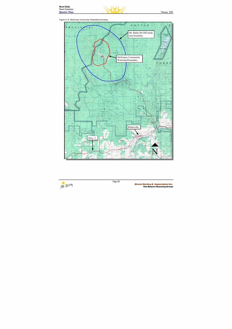
8/12/2019 Mount Baldy
http://slidepdf.com/reader/full/mount-baldy 68/322
Mount BaldyResort Expansion
Master Plan February 2005
Page 50 Brent Harley & Associates Inc.
The Resort Planning Group
Figure 3-10 McKinney Community Watershed boundary.
Bridesville
Hwy. 3
Mt. Baldy Ski Hill study
area boundary.
McKinney Community
Watershed boundary.
8/12/2019 Mount Baldy
http://slidepdf.com/reader/full/mount-baldy 69/322
Mount BaldyResort Expansion
Master Plan February 2005
Page 51 Brent Harley & Associates Inc.
The Resort Planning Group
33..44..44..11 EERROOSSIIOONN AANNDD SSEEDDIIMMEENNTT CCOONNTTRROOLL BBEESSTT MMAANNAAGGEEMMEENNTT PPRRAACCTTIICCEESS
The MBSC accepts that the erosion of surface soils is a primary factor in the degradation ofwater quality and fish habitat. To this end, we propose to adopt standard industry bestmanagement practices for erosion and sediment control, focused on minimizing the area ofexposed soils, and seeding soils exposed as part of infrastructure development.Erosion and sediment control Best Management Practices will be utilized where appropriate.BMPs are available from a number of sources including the ‘Fish-stream Crossing Guidebook39’,‘Best Management Practices Handbook: Hillslope Restoration in British Columbia40’, as well asresources available from the International Erosion Control Association website41.
33..44..44..22 RRIIPPAARRIIAANN AANNDD FFIISSHH HHAABBIITTAATT
The location, type and quality of fish habitat is an essential component of applying appropriateriparian management area strategies as well as providing fish passage at stream crossings.
As part of this assessment, a review of available fish and fish habitat information wasundertaken and supplemented with field assessments where existing information was lacking or
incomplete. The review of existing fish and fish habitat information included:
1) fish presence/absence surveys completed by the forest licensee (Weyerhaeuser CompanyLtd.);
2) data available on the Fish Inventory Summary System; and3) surveys completed as part of the environmental assessment for the Southern Crossing
Project (BC Gas). Where data was lacking or incomplete, field assessments to assess fishand fish habitat were undertaken using methodology described in the Reconnaissance Fishand Fish Habitat Inventory Manual42 and the Fish-stream Identification Guidebook43.
Figure 3-11 shows the known distribution of fish within the study area. Fish absence has beenconfirmed on all streams within the study area with the exception of two: 1) the upper reaches ofMcIntyre Creek; and 2) the upper reaches of Wapiti Creek. For the upper reaches of WapitiCreek, however, the stream is shown as an assumed non fish-stream. Based on a previousfisheries assessment (SSS 2002) the poor quality of fish habitat is likely to be a limiting factor tofish distribution.
Prior to undertaking this assessment, there was no existing fish inventory information forMcKinney Creek with the exception of a combined electrofishing and minnow trapping surveyconducted by the Westland Resource Group (WRG) as part of the BC Gas Southern CrossingProject. The survey site was located just upstream of the 15m high falls located by Snowy RiverResources Ltd. Although no fish were captured by WRG, the report does not provide a rationalefor the non fish-bearing status that they recommended.
As part of this project, Snowy River Resources Ltd. undertook a fish inventory of McKinneyCreek. As a result, a 15m high bedrock falls was identified as the upstream limit of fish.Rainbow trout and eastern brook trout were captured downstream of the falls. However, no fishwere captured upstream of the falls during an electrofishing survey at 3 sites with a total of600m of stream sampled (Figure 3-12). The 15m high falls, as well as the electrofishing survey
39 http://www.for.gov.bc.ca/tasb/legsregs/fpc/FPCGUIDE/FishStreamCrossing/FSCGdBk.pdf 40 http://www.for.gov.bc.ca/hfd/pubs/Docs/Mr/Mr096.htm 41 http://www.ieca.org 42 Source: http://srmwww.gov.bc.ca/risc/pubs/aquatic/recon/index.htm 43 Source: http://www.for.gov.bc.ca/tasb/legsregs/fpc/FPCGUIDE/FishStreamCrossing/FSCGdBk.pdf
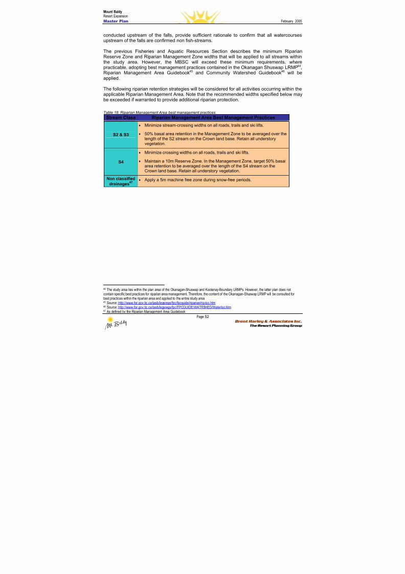
8/12/2019 Mount Baldy
http://slidepdf.com/reader/full/mount-baldy 70/322
Mount BaldyResort Expansion
Master Plan February 2005
Page 52 Brent Harley & Associates Inc.
The Resort Planning Group
conducted upstream of the falls, provide sufficient rationale to confirm that all watercoursesupstream of the falls are confirmed non fish-streams.
The previous Fisheries and Aquatic Resources Section describes the minimum RiparianReserve Zone and Riparian Management Zone widths that will be applied to all streams withinthe study area. However, the MBSC will exceed these minimum requirements, wherepracticable, adopting best management practices contained in the Okanagan Shuswap LRMP44,Riparian Management Area Guidebook45 and Community Watershed Guidebook46 will beapplied.
The following riparian retention strategies will be considered for all activities occurring within theapplicable Riparian Management Area. Note that the recommended widths specified below maybe exceeded if warranted to provide additional riparian protection.
Table 16: Riparian Management Area best management practices
Stream Class Riparian Management Area Best Management Practices
S2 & S3
• Minimize stream-crossing widths on all roads, trails and ski lifts.
• 50% basal area retention in the Management Zone to be averaged over thelength of the S2 stream on the Crown land base. Retain all understoryvegetation.
S4
• Minimize crossing widths on all roads, trails and ski lifts.
• Maintain a 10m Reserve Zone. In the Management Zone, target 50% basalarea retention to be averaged over the length of the S4 stream on theCrown land base. Retain all understory vegetation.
Non classified
drainages47
• Apply a 5m machine free zone during snow-free periods.
44 The study area lies within the plan area of the Okanagan-Shuswap and Kootenay-Boundary LRMPs. However, the latter plan does notcontain specific best practices for riparian area management. Therefore, the content of the Okanagan-Shuswap LRMP will be consulted forbest practices within the riparian area and applied to the entire study area.45 Source: http://www.for.gov.bc.ca/tasb/legsregs/fpc/fpcguide/riparian/rip-toc.htm 46 Source: http://www.for.gov.bc.ca/tasb/legsregs/fpc/FPCGUIDE/WATRSHED/Watertoc.htm 47 As defined by the Riparian Management Area Guidebook
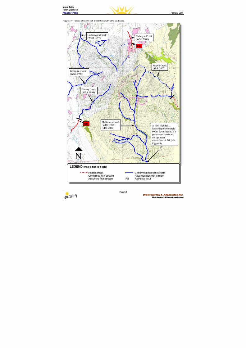
8/12/2019 Mount Baldy
http://slidepdf.com/reader/full/mount-baldy 71/322
Mount BaldyResort Expansion
Master Plan February 2005
Page 53 Brent Harley & Associates Inc.
The Resort Planning Group
Figure 3-11 Status of known fish distributions within the study area.
LEGEND (Map Is Not To Scale)
Reach break Confirmed non fish-streamConfirmed fish-stream Assumed non fish-stream
Assumed fish-stream RB Rainbow trout
Wapiti Creek
(SRR 2002)
A 15m high falls,
located approximately600m downstream, is a
permanent barrier to
the upstreammovement of fish (see
Figure 8).
McKinney Creek
(WRC 1998)
(SRR 2004)
RB
Coteay Creek
(WSR 1998)
McIntyre Creek
(WSE 2000)
RB
Gregoire Creek
(WSR 1998)
Underdown Creek(WSR 1997)
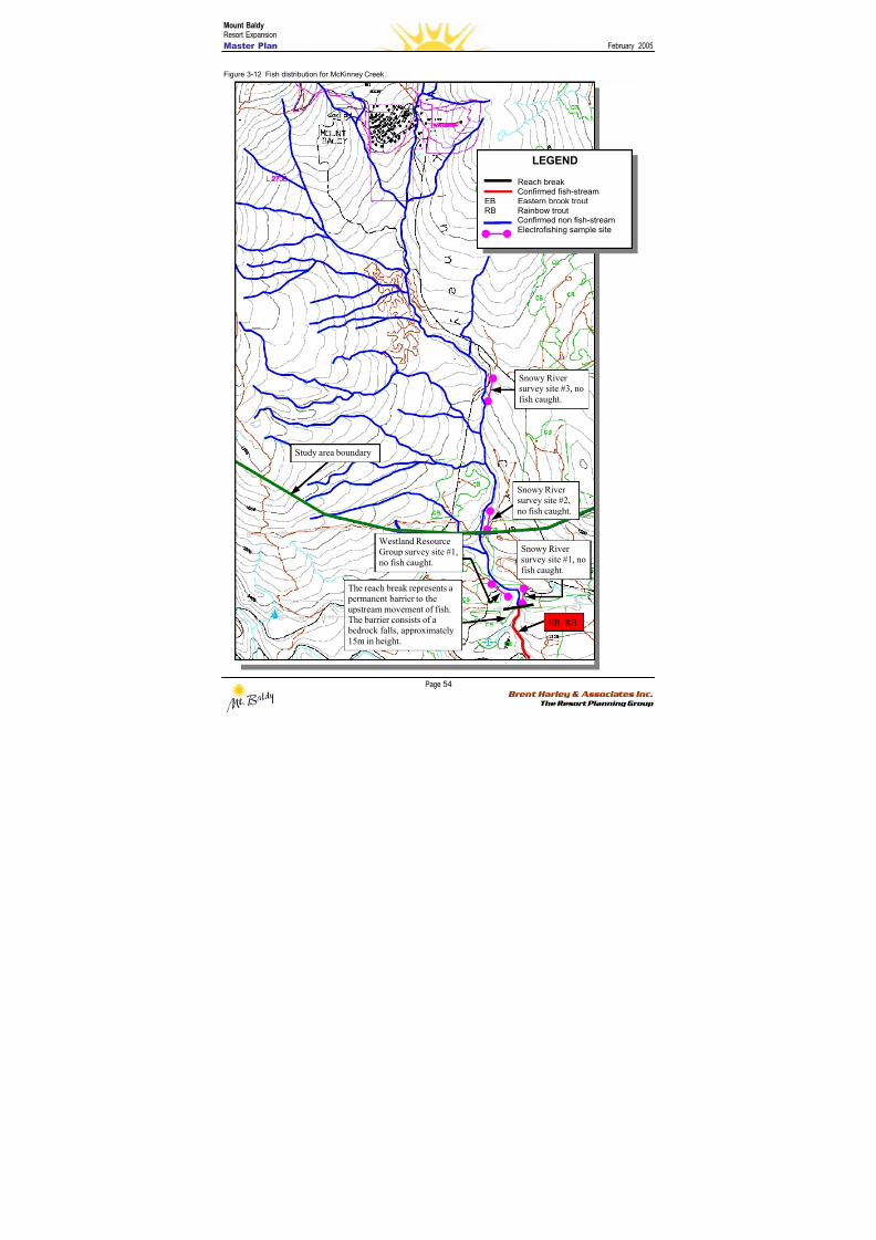
8/12/2019 Mount Baldy
http://slidepdf.com/reader/full/mount-baldy 72/322
Mount BaldyResort Expansion
Master Plan February 2005
Page 54 Brent Harley & Associates Inc.
The Resort Planning Group
Figure 3-12 Fish distribution for McKinney Creek.
Snowy River
survey site #2,
no fish caught.
The reach break represents a
permanent barrier to the
upstream movement of fish.The barrier consists of a
bedrock falls, approximately
15m in height.
EB, RB
Snowy River
survey site #1, nofish caught.
LEGEND
Reach breakConfirmed fish-stream
EB Eastern brook troutRB Rainbow trout
Confirmed non fish-streamElectrofishing sample site
Study area boundary
Westland Resource
Group survey site #1,
no fish caught.
Snowy Riversurvey site #3, no
fish caught.
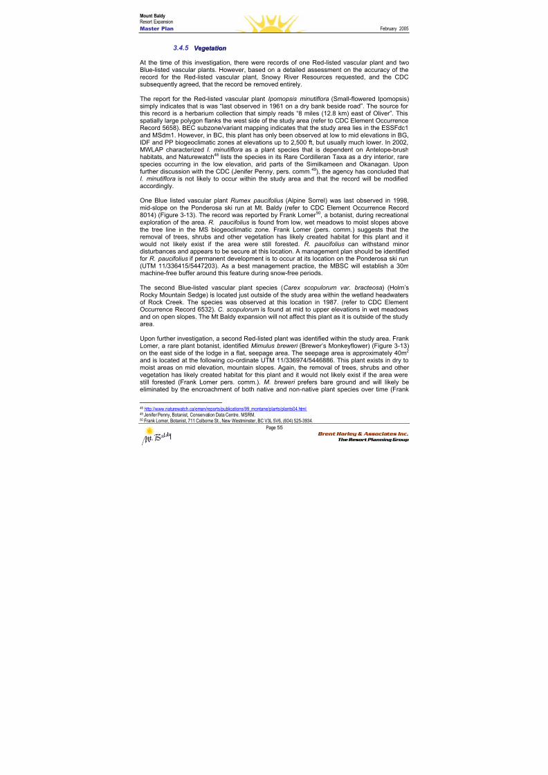
8/12/2019 Mount Baldy
http://slidepdf.com/reader/full/mount-baldy 73/322
Mount BaldyResort Expansion
Master Plan February 2005
Page 55 Brent Harley & Associates Inc.
The Resort Planning Group
3.4.5 V V eeg g eet t aat t i i oonn
At the time of this investigation, there were records of one Red-listed vascular plant and twoBlue-listed vascular plants. However, based on a detailed assessment on the accuracy of therecord for the Red-listed vascular plant, Snowy River Resources requested, and the CDC
subsequently agreed, that the record be removed entirely.
The report for the Red-listed vascular plant Ipomopsis minutiflora (Small-flowered Ipomopsis)simply indicates that is was “last observed in 1961 on a dry bank beside road”. The source forthis record is a herbarium collection that simply reads “8 miles (12.8 km) east of Oliver”. Thisspatially large polygon flanks the west side of the study area (refer to CDC Element OccurrenceRecord 5658). BEC subzone/variant mapping indicates that the study area lies in the ESSFdc1and MSdm1. However, in BC, this plant has only been observed at low to mid elevations in BG,IDF and PP biogeoclimatic zones at elevations up to 2,500 ft, but usually much lower. In 2002,MWLAP characterized I. minutiflora as a plant species that is dependent on Antelope-brushhabitats, and Naturewatch48 lists the species in its Rare Cordilleran Taxa as a dry interior, rarespecies occurring in the low elevation, arid parts of the Similkameen and Okanagan. Uponfurther discussion with the CDC (Jenifer Penny, pers. comm.49), the agency has concluded thatI. minutiflora is not likely to occur within the study area and that the record will be modifiedaccordingly.
One Blue listed vascular plant Rumex paucifolius (Alpine Sorrel) was last observed in 1998,mid-slope on the Ponderosa ski run at Mt. Baldy (refer to CDC Element Occurrence Record8014) (Figure 3-13). The record was reported by Frank Lomer 50, a botanist, during recreationalexploration of the area. R. paucifolius is found from low, wet meadows to moist slopes abovethe tree line in the MS biogeoclimatic zone. Frank Lomer (pers. comm.) suggests that theremoval of trees, shrubs and other vegetation has likely created habitat for this plant and itwould not likely exist if the area were still forested. R. paucifolius can withstand minordisturbances and appears to be secure at this location. A management plan should be identifiedfor R. paucifolius if permanent development is to occur at its location on the Ponderosa ski run(UTM 11/336415/5447203). As a best management practice, the MBSC will establish a 30mmachine-free buffer around this feature during snow-free periods.
The second Blue-listed vascular plant species (Carex scopulorum var. bracteosa) (Holm’sRocky Mountain Sedge) is located just outside of the study area within the wetland headwatersof Rock Creek. The species was observed at this location in 1987. (refer to CDC ElementOccurrence Record 6532). C. scopulorum is found at mid to upper elevations in wet meadowsand on open slopes. The Mt Baldy expansion will not affect this plant as it is outside of the studyarea.
Upon further investigation, a second Red-listed plant was identified within the study area. FrankLomer, a rare plant botanist, identified Mimulus breweri (Brewer’s Monkeyflower) (Figure 3-13)on the east side of the lodge in a flat, seepage area. The seepage area is approximately 40m2 and is located at the following co-ordinate UTM 11/336974/5446886. This plant exists in dry tomoist areas on mid elevation, mountain slopes. Again, the removal of trees, shrubs and othervegetation has likely created habitat for this plant and it would not likely exist if the area werestill forested (Frank Lomer pers. comm.). M. breweri prefers bare ground and will likely beeliminated by the encroachment of both native and non-native plant species over time (Frank
48 http://www.naturewatch.ca/eman/reports/publications/99_montane/plants/plants04.html 49 Jenifer Penny, Botanist, Conservation Data Centre, MSRM.50 Frank Lomer, Botanist, 711 Colborne St., New Westminster, BC V3L 5V6, (604) 525-3934.
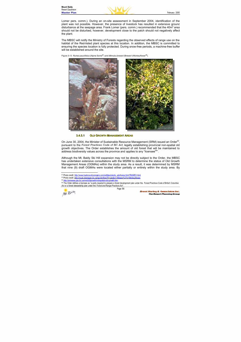
8/12/2019 Mount Baldy
http://slidepdf.com/reader/full/mount-baldy 74/322
Mount BaldyResort Expansion
Master Plan February 2005
Page 56 Brent Harley & Associates Inc.
The Resort Planning Group
Lomer pers. comm.). During an on-site assessment in September 2004, identification of theplant was not possible. However, the presence of livestock has resulted in extensive grounddisturbance at the seepage area. Frank Lomer (pers. comm.) recommended that the 40m2 areashould not be disturbed, however, development close to the patch should not negatively affectthe plant.
The MBSC will notify the Ministry of Forests regarding the observed effects of range use on thehabitat of the Red-listed plant species at this location. In addition, the MBSC is committed toensuring the species location is fully protected. During snow-free periods, a machine-free bufferwill be established around the site.
Figure 3-13 Rumex paucifolius (Alpine Sorrel51) and Mimulus breweri (Brewer’s Monkeyflower 52).
33..44..55..11 OOLLDD GGRROOWWTTHH MMAANNAAGGEEMMEENNTT AARREEAASS
On June 30, 2004, the Minister of Sustainable Resource Management (SRM) issued an Order 53,pursuant to the Forest Practices Code of BC Act , legally establishing provincial non-spatial oldgrowth objectives. The Order establishes the amount of old forest that will be maintained toaddress biodiversity values across the province and applies to any “licensee54”.
Although the Mt. Baldy Ski Hill expansion may not be directly subject to the Order, the MBSChas undertaken extensive consultations with the MSRM to determine the status of Old GrowthManagement Areas (OGMAs) within the study area. As a result, it was determined by MSRMthat nine (9) draft OGMAs were located either partially or entirely within the study area. By
51 Photo credit: http://www.backcountryrangers.com/edibles/plants_soloframe.html?RUMEX.html 52 Photo credit: http://royal.okanagan.bc.ca/cgi-bin/flow?f1=yes&c1=Brewer%27s+Monkeyflower 53 http://srmwww.gov.bc.ca/rmd/oldgrowth/nonspatial-old-growth.htm.54 The Order defines a licensee as “a party required to prepare a forest development plan under the Forest Practices Code of British Columbia Act or a forest stewardship plan under the Forest and Range Practices Act” .

8/12/2019 Mount Baldy
http://slidepdf.com/reader/full/mount-baldy 75/322
Mount BaldyResort Expansion
Master Plan February 2005
Page 57 Brent Harley & Associates Inc.
The Resort Planning Group
cross-referencing the location of the 9 draft OGMAs with planned ski lifts, ski runs andassociated infrastructure, the MBSC determined that approximately 10.7% of the total area(17.22ha.) of draft OGMAs would require modification in the form of clearing.
By request of the MBSC, the MSRM have approved planned modification activities and haveagreed to eliminate OGMA #39 entirely (Frank Wilmer, MSRM, in communication by e-mail withDoug Wahl. The MSRM Kamloops Region have agreed to review a similar request for threeOGMAs in early January (Susan Omelchuk, MSRM, in communication with Doug Wahl).
The MBSC fully supports government’s initiative to protect old growth and will make every effortto ensure the integrity of these features within the existing base area and planned expansionarea. However, the MBSC will not assume legal responsibility in the event that approvedclearing triggers windthrow within the OGMA. Prior to commencing forest clearing within anOGMA, the MBSC will review the Ministry of Forests e-learning web site on windthrow55. TheMBSC will also report any significant amount of windthrow within an OGMA to MSRM.
Table 17: OGMAs located within the study area boundary and estimated clearing required to accommodate plannedinfrastructure.
Draft OGMAReference #
MSRMRegion
Area of DraftOGMA
Estimatedarea to be
cleared
% of Draft OGMAto be cleared
5 Kootenay 44.03ha. 2.20ha. 5%
6 Kootenay 33.5ha. 1.34ha. 4%
30 Kootenay 6.23ha. 1.56ha. 25%
39 Kootenay 2.37ha. 2.13ha. 90%
56 Kootenay 6.51ha. 0.33ha. 5%
40 Kootenay 11.1ha. 1.66ha. 15%
99 Kamloops 22.16ha. 5.53ha. 25%
100 Kamloops 3.08ha. 1.85ha. 60%
78D Kamloops 31.24ha. 0.62ha. 2%
Totals 160.4ha. 17.22ha. 10.7%
55 http://www.for.gov.bc.ca/HFP/FORDEV/windthrow
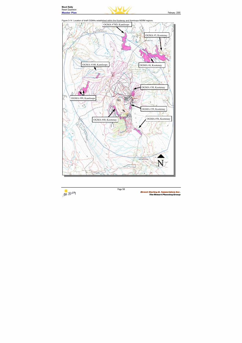
8/12/2019 Mount Baldy
http://slidepdf.com/reader/full/mount-baldy 76/322
Mount BaldyResort Expansion
Master Plan February 2005
Page 58 Brent Harley & Associates Inc.
The Resort Planning Group
Figure 3-14 Location of draft OGMAs established within the Kootenay and Kamloops MSRM regions.
OGMA #78D, Kamloops
OGMA #6, Kootenay
OGMA #5, Kootenay
OGMA #30, Kootenay
OGMA #39, Kootenay
OGMA #56, Kootenay
OGMA #100, Kamloops
OGMA #40, Kootenay
OGMA #99, Kamloops
8/12/2019 Mount Baldy
http://slidepdf.com/reader/full/mount-baldy 77/322
Mount BaldyResort Expansion
Master Plan February 2005
Page 59 Brent Harley & Associates Inc.
The Resort Planning Group
3.4.6 S S u u mmmmaar r y y aannd d R R eec c oommmmeennd d aat t i i oonnss
This report includes a detailed assessment and inventory of resource values within the Mt.Baldy Ski Hill study area as defined by the Ministry of Water, Land and Air Protection, theMinistry of Sustainable Resource Management and the undersigned. In concert with the type,
extent and quality of fish and wildlife habitat values identified within the study area, a range ofmitigation measures have been identified – all of which meet or exceed accepted best practicesand legislated requirements governing Crown land activities, such as forest and range practices.The following tables provide a summary of identified resource values within the study area aswell as actions proposed by the Mt. Baldy Ski Corporation to protect these values.
Table 18: Vegetation and wildlife habitat resource values within the study area.
Resource values/issues identified bythe Mt. Baldy Ski Corporation (MBSC),
MWLAP or MSRM
Summary of actions proposed by the MBSC to protectresource values
• The Conservation Data Centre (CDC)has site specific records for one Red-listed plant, Brewer’s Monkeyflower, andone Blue-listed plant, Alpine Sorrel areknown to occur within the study area.
• Guidance on management strategies was obtained byFrank Lomer, a botanist, and the CDC.
• The known area (40m2) supporting Brewer’sMonkeyflower (adjacent to the existing day lodge) willnot be developed. If practicable, the area will be fencedduring the summer months and a no machine buffer willbe established.
• The known location of Alpine Sorrel will be protected byestablishing a machine free buffer, to be applied duringsnow-free periods.
• The CDC confirmed that there are norecords of Red or Blue-listed mammals,birds, reptiles, amphibians, fish or
invertebrates within or immediatelyadjacent to the study area.
• The MBSC will consider developing an observationdatabase of rare wildlife. This information would beprovided to MWLAP. If any observations of Red or Blue
listed species are made, this information will be reportedto the CDC
56.
• The MSRM have completed draft OldGrowth Management Area (OGMA)mapping for the study area. There are 9OGMAs within the study area (6 withinthe Kootenay Region and 3 within theKamloops Region) that may be affectedby the proposed development.57
• The MSRM, Kootenay Region, have approved theplanned activities within the 6 OGMAs.
• At the time of writing, the MSRM, Kamloops Region, hadnot yet reviewed the submission detailing the plannedactivities within the 3 OGMAs. This review is expected tocommence within the first week of January. NB status?
• The MBSC supports the protection of old growth and willcontinue to work with the MSRM to ensure that theintegrity and function of the old growth patches are
maintained.
• Prior to commencing this assessment,the availability of wildlife habitatmapping within the study area waslimited to Terrestrial Ecosystem
• The planned winter-use activities are not likely to affecthabitat suitability for elk or lynx (Brian Harris, pers.comm.). Nonetheless, the MBSC will apply theCommercial Recreation Wildlife Guidelines
60 for lynx
56 Refer to http://srmwww.gov.bc.ca/cdc/contribute.html for instructions on contributing data to the CDC.57 In accordance to the OGMA Implementation Policy, the retention of OGMAs may not be a legal requirement under this application. Seehttp://srmwww.gov.bc.ca/rmd/oldgrowth
8/12/2019 Mount Baldy
http://slidepdf.com/reader/full/mount-baldy 78/322
Mount BaldyResort Expansion
Master Plan February 2005
Page 60 Brent Harley & Associates Inc.
The Resort Planning Group
Mapping (TEM) with wildlife habitatratings for TFL 1558, with approximately20% coverage of the study area.
• To assess habitat suitability within theremaining study area, wildlife habitat
ratings were extrapolated (highsuitability only) over the entire studyarea using accepted RISC59 methodology. Several high habitatsuitability habitats were identified withinthe study area including habitat for lynxand elk (summer only, located within thehigh elevation parkland of Mt. Baldy).However, there are no records of elkuse of this area.
where appropriate.
• The MBSC supports MWLAPs recommendation (BrianHarris pers. comm.) that a Qualified Professional shouldassess elk habitat use in the ESSFdcp1 once athreshold of >500 person days/month of use is
exceeded during June-October.
• There are no known wildlife habitatfeatures within the study area.
• There are no Wildlife Habitat Areaseither approved or proposed within orimmediately adjacent to the study area.
• No Sensitive Ecosystem Inventories61
(Mapping) are available for areas withinor adjacent to the study area.
• Within areas under it’s direct control, the MBSC will fullycomply with provisions of the Wildlife Act (Section 3462)
and the Migratory Birds Regulations (Section 663
) withregard to disturbing the active nest of a bird. Any treeswith active nests as observed or reported to the MBSCstaff will be protected. A ‘no disturbance buffer, of up to50m, may be applied around the nest tree.
• Where a species or its habitat is identified, the MBSCwill utilize several published sources to implementtargeted management strategies. These include: 1)Interim Commercial Recreation Wildlife Guidelines64; 2)
The Identified Wildlife Management Strategy65
; and, 3)
the Habitat Atlas for Wildlife at Risk66
. Once published,the MBSC will consider relevant components of theWildlife Habitat Features Initiative for direction in
determining appropriate management strategies wherefeatures such as a mineral lick or nest site are identified.
• There are no known records of bear-human conflicts within the study area.
• The MBSC has prepared a draft bear management planwith the intent of working cooperatively with theRegional District of Kootenay Boundary to ensure it’s fullimplementation (see section 3.7).
• The study area or adjacent areas arenot mapped by MWLAP as UngulateWinter Range.
• Not applicable.
58 ftp://ftp.env.gov.bc.ca/dist/wis/tem/warehouse/region_3/okanagan_falls 59 http://srmwww.gov.bc.ca/risc/about.htm 60 http://wlapwww.gov.bc.ca/wld/comrec/crecintro.html 61 http://srmwww.gov.bc.ca/sei/index.html.62 http://www.qp.gov.bc.ca/statreg/stat/W/96488_01.htm.63 http://laws.justice.gc.ca/en/M-7.01/C.R.C.-c.1035/147324.html.64 Source: http://wlapwww.gov.bc.ca/wld/comrec/crecintro.html.65 Source: http://wlapwww.gov.bc.ca/wld/identified/iwms2004.html.66 Source: http://wlapwww.gov.bc.ca/sir/fwh/wld/atlas/introduction/intro_index.html
8/12/2019 Mount Baldy
http://slidepdf.com/reader/full/mount-baldy 79/322
Mount BaldyResort Expansion
Master Plan February 2005
Page 61 Brent Harley & Associates Inc.
The Resort Planning Group
Table 19: Water Quality, Riparian and Fish Habitat Values within the Study Area
Resource values/issues identified bythe Mt. Baldy Ski Corporation (MBSC),
MWLAP or MSRM
Summary of actions proposed by the MBSC to protectresource values
• The base area infrastructure, includingthe ski hill, lodging and recreationalfacilities are located within theMcKinney Creek watershed.
• The protection of riparian habitat, downstream fishhabitat and water quality, is a key component of thebase area design as well as other planneddevelopments within the study area.
• The upper reaches of McKinney Creekare located within the McKinneyCommunity Watershed67. There are nolegally established objectives or otherrequirements within this designatedwatershed.
• All non fish-streams within the study area, includingthose outside of the McKinney Community Watershed,will, at a minimum, be provided the same level ofprotection as fish-streams except that works in or abouta stream are not restricted to the instream operatingwindow and fish passage at stream crossing structuresis not required.
• Where activities are planned adjacent to a riparian area,the stream, lake or wetland will be classified in
accordance to the Operational & Site PlanningRegulation
68 and/or the Forest Planning and Practices
Regulation69
and the Riparian Management AreaGuidebook70.
• In accordance to the guidelines contained in theOkanagan-Shuswap LRMP
71, where practicable, all S4
(<1.5m wide) streams will have a minimum 10m reservezone and all watercourses will have a 5m machine freezone.
• The portion of McKinney Creek withinthe study area is non fish bearing. A15m high bedrock falls, located severalkilometers downstream of the studyarea, prevents all fish movementupstream.
• It is the opinion of the ProfessionalBiologist, Doug Wahl, RPBio, that thedevelopment will in no way result in a
HADD under Section 35(1) of theFisheries Act, therefore, the CEAAshould not be triggered
• All works in or about a stream will be undertaken in amanner consistent with the 2004 MWLAP publication‘Standards and Practices for Instream Works’72.
• Erosion and sediment control Best ManagementPractices will be utilized where appropriate. BMPs willbe sourced from the ‘Fish-stream CrossingGuidebook73’, ‘Best Management Practices Handbook:Hillslope Restoration in British Columbia74’, as well asresources available from the International ErosionControl Association website75.
67 Source: http://srmwww.gov.bc.ca/wat/cws/query/cws.htm 68 http://www.for.gov.bc.ca/tasb/legsregs/fpc/fpcaregs/oplanreg/opr.htm 69 http://www.for.gov.bc.ca/tasb/legsregs/frpa/frparegs/forplanprac/fppr.htm 70 http://www.for.gov.bc.ca/tasb/legsregs/fpc/fpcguide/riparian/rip-toc.htm 71 http://srmwww.gov.bc.ca/sir/lrmp/okan/ 72 http://wlapwww.gov.bc.ca/wld/documents/bmp/iswstdsbpsmarch2004.pdf 73 http://www.for.gov.bc.ca/tasb/legsregs/fpc/FPCGUIDE/FishStreamCrossing/FSCGdBk.pdf 74 http://www.for.gov.bc.ca/hfd/pubs/Docs/Mr/Mr096.htm 75 http://www.ieca.org

8/12/2019 Mount Baldy
http://slidepdf.com/reader/full/mount-baldy 80/322
Mount BaldyResort Expansion
Master Plan February 2005
Page 62 Brent Harley & Associates Inc.
The Resort Planning Group
33..55 GGEEOOTTEECCHHNNIICCAALL CCOONNSSIIDDEERRAATTIIOONNSS
The Okanagan Highlands Ecosection is characterised by long, rounded ridges and deep widevalleys. The area provides transitional terrain from the Thompson Plateau in the west and theColumbia Mountains to the east. In general, the mountain ranges within this area are composed
of folded and metamorphosed sedimentary and volcanic rocks. Peaks and ridges show theeffects of intense alpine glaciation and cirque basins are particularly noticeable on north andnortheastern aspects76.
The geological history of the Okanagan Valley includes at least three significant glaciationperiods, and this in part has resulted in the existence of seven different surficial deposits withinthe Mount Baldy area. These deposits include: moraine, glaciofluvial, colluvial, fluvial, organic,glaciolacustine and eolin parent materials77.
Other research in the area indicates that the soils structures in the area include Brunisols,Regosols, Podzols, Luvisols, Gleysols, as well as Organics in the higher elevations78.
Although the Mt. Baldy area is not known to possess significant geotechnical instabilities, whereappropriate, detailed geotechnical assessments will be undertaken prior to any proposeddevelopment. These assessments will draw from the terrain stability assessments previouslyundertaken as part of the Okanagan Terrain Stability Project, and will be conducted, analysedand compiled by a professional engineer experienced in the field of geotechnical sciences.
76 Campbell, R.W., N.K. Dawe, I . McTaggart-Cowan, J.M. Cooper, G.W. Kaiser and C.E. McNall, eds. 1990a. The Birds of British Columbia.Vol. I. Nonpasserines; Introduction, Loons through Waterfowl. Royal B.C. Mus. Victoria, BC. 514 pp.77 Geowest Environmental Consultants Ltd., 2000, “Terrestrial Ecosystem Mapping with Wildlife Interpretations for Weyerhauser TFL 15 –Volume 1: Terrestrial Ecosystem Mapping with Expanded Legends for Terrestrial Ecosystem Units”.78 ibid
8/12/2019 Mount Baldy
http://slidepdf.com/reader/full/mount-baldy 81/322
Mount BaldyResort Expansion
Master Plan February 2005
Page 63 Brent Harley & Associates Inc.
The Resort Planning Group
44..00 EExxppaannssiioonn MMaasstteer r PPllaann
This section presents the proposed Master Plans for the expansion of both the mountainfacilities and base area developments. Each is detailed in its proposed mountain build-outcondition, however it is important to note that the integrated phasing plan, as presented in
Section 5, demonstrates the fact that all phases are internally balanced and coordinated. This isa key factor in ensuring that the development of Mount Baldy will continue to be successful ateach stage of its development. Further, while this section details the build-out capacities, it mustbe noted that movement from one phase to the next is only initiated when market conditions,ongoing resort capacities and resort area trends all indicate that there is a business case fordoing so. As such, the Plan for each phase has been fully balanced, integrated and coordinatedso as to be a finished resort product in its own right, without having to rely on a subsequentphase to complete the offering.
Consistent with Mount Baldy’s adventure and backcountry orientation, the lift and trail systemhas been designed such that Nordic and backcountry skiers will be able to circulate throughoutthe whole of the Controlled Recreation Area. As planned, low gradient trails are available for
descent from the top of each ski lift. Conversely, the same trails will enable uphill access forbackcountry and Nordic skiers, as well as snowshoers and mountain bikers. This designobjective has been applied to, and achieved in each of the phases of mountain development.
Section 4.1 details the Mountain Master Plan, while 4.2 is dedicated to specifying the scale andscope of the associated Base Area Development Plan.
44..11 MMOOUUNNTTAAIINN MMAASSTTEERR PPLLAANN
In terms of terrain and physical capability, it is clear that much of the land within the study areais well suited to additional alpine ski resort development. The mountain exhibits a strongconsistency of terrain, a reliable snowpack, a variety of ski terrain orientations, and good fall-line
skiing opportunities.
Of equal importance, the terrain in the proposed ski area is capable of supporting a sufficientComfortable Carrying Capacity to achieve the project goals and objectives as outlined inSections 1.4 & 1.5.
This section details the extent of ski area development that is proposed for the Mount BaldyExpansion. It also illustrates the exact configuration of all proposed lifts, trails and glading areasat buildout, as well as demonstrating the associated capacities, and market distribution of skiterrain. Detailed phasing of the proposed Mountain Master Plan is further expanded withinSection 5.0 – Implementation Strategy.
4.1.1 M M oou u nnt t aai i nn DDeev v eel l oo p pmmeennt t G G ooaal l ss
Building upon the identified goals and objectives of the Mount Baldy Ski Corporation, we believethat there is a significant opportunity to expand the existing mountain facilities in a manner thatwill provide a unique and special mountain resort experience, one different than what is typicallyfound in the North American marketplace at the present time. By not offering “more-of-the-same”, Mt. Baldy will act as a complement to the existing resorts in the Okanagan Valley. It isthe intent of the mountain development plans to provide the blueprint to define, describe anddevelop an alpine environment that anticipates and capitalizes on evolving market trends,
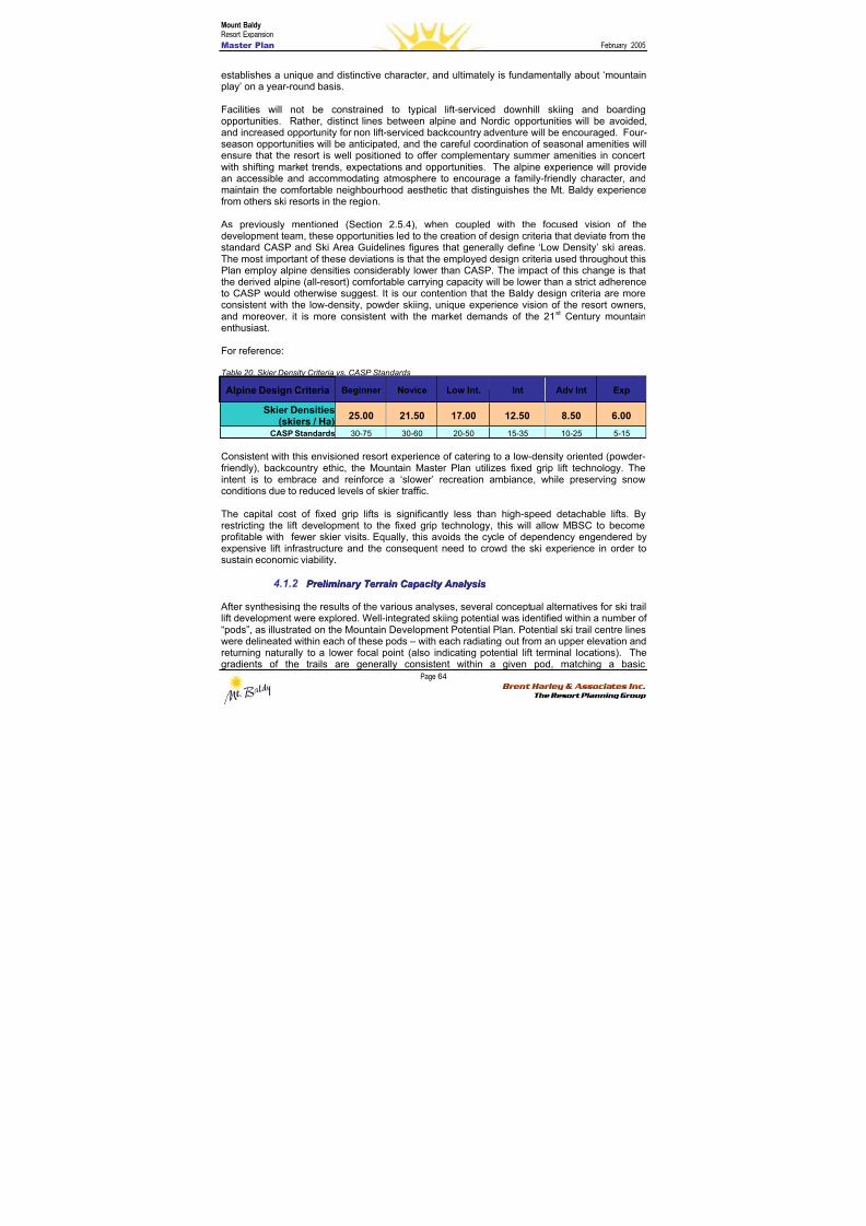
8/12/2019 Mount Baldy
http://slidepdf.com/reader/full/mount-baldy 82/322
Mount BaldyResort Expansion
Master Plan February 2005
Page 64 Brent Harley & Associates Inc.
The Resort Planning Group
establishes a unique and distinctive character, and ultimately is fundamentally about ‘mountainplay’ on a year-round basis.
Facilities will not be constrained to typical lift-serviced downhill skiing and boardingopportunities. Rather, distinct lines between alpine and Nordic opportunities will be avoided,and increased opportunity for non lift-serviced backcountry adventure will be encouraged. Four-season opportunities will be anticipated, and the careful coordination of seasonal amenities willensure that the resort is well positioned to offer complementary summer amenities in concertwith shifting market trends, expectations and opportunities. The alpine experience will providean accessible and accommodating atmosphere to encourage a family-friendly character, andmaintain the comfortable neighbourhood aesthetic that distinguishes the Mt. Baldy experiencefrom others ski resorts in the region.
As previously mentioned (Section 2.5.4), when coupled with the focused vision of thedevelopment team, these opportunities led to the creation of design criteria that deviate from thestandard CASP and Ski Area Guidelines figures that generally define ‘Low Density’ ski areas.The most important of these deviations is that the employed design criteria used throughout thisPlan employ alpine densities considerably lower than CASP. The impact of this change is thatthe derived alpine (all-resort) comfortable carrying capacity will be lower than a strict adherenceto CASP would otherwise suggest. It is our contention that the Baldy design criteria are moreconsistent with the low-density, powder skiing, unique experience vision of the resort owners,and moreover, it is more consistent with the market demands of the 21st Century mountainenthusiast.
For reference:
Table 20. Skier Density Criteria vs. CASP Standards
Alpine Design Criteria Beginner Novice Low Int. Int Adv Int Exp
Skier Densities(skiers / Ha) 25.00 21.50 17.00 12.50 8.50 6.00
CASP Standards 30-75 30-60 20-50 15-35 10-25 5-15
Consistent with this envisioned resort experience of catering to a low-density oriented (powder-friendly), backcountry ethic, the Mountain Master Plan utilizes fixed grip lift technology. Theintent is to embrace and reinforce a ‘slower’ recreation ambiance, while preserving snowconditions due to reduced levels of skier traffic.
The capital cost of fixed grip lifts is significantly less than high-speed detachable lifts. Byrestricting the lift development to the fixed grip technology, this will allow MBSC to becomeprofitable with fewer skier visits. Equally, this avoids the cycle of dependency engendered byexpensive lift infrastructure and the consequent need to crowd the ski experience in order tosustain economic viability.
4.1.2 P P r r eel l i i mmi i nnaar r y y T T eer r r r aai i nn C C aa p paac c i i t t y y A Annaal l y y ssi i ss
After synthesising the results of the various analyses, several conceptual alternatives for ski traillift development were explored. Well-integrated skiing potential was identified within a number of“pods”, as illustrated on the Mountain Development Potential Plan. Potential ski trail centre lineswere delineated within each of these pods – with each radiating out from an upper elevation andreturning naturally to a lower focal point (also indicating potential lift terminal locations). Thegradients of the trails are generally consistent within a given pod, matching a basic
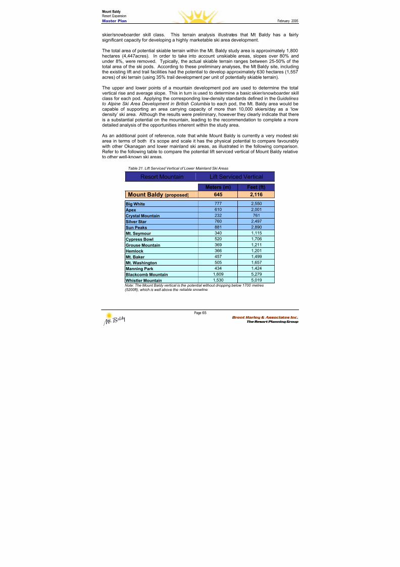
8/12/2019 Mount Baldy
http://slidepdf.com/reader/full/mount-baldy 83/322
Mount BaldyResort Expansion
Master Plan February 2005
Page 65 Brent Harley & Associates Inc.
The Resort Planning Group
skier/snowboarder skill class. This terrain analysis illustrates that Mt Baldy has a fairlysignificant capacity for developing a highly marketable ski area development.
The total area of potential skiable terrain within the Mt. Baldy study area is approximately 1,800hectares (4,447acres). In order to take into account unskiable areas, slopes over 80% andunder 8%, were removed. Typically, the actual skiable terrain ranges between 25-50% of thetotal area of the ski pods. According to these preliminary analyses, the Mt Baldy site, includingthe existing lift and trail facilities had the potential to develop approximately 630 hectares (1,557acres) of ski terrain (using 35% trail development per unit of potentially skiable terrain).
The upper and lower points of a mountain development pod are used to determine the totalvertical rise and average slope. This in turn is used to determine a basic skier/snowboarder skillclass for each pod. Applying the corresponding low-density standards defined in the Guidelinesto Alpine Ski Area Development in British Columbia to each pod, the Mt. Baldy area would becapable of supporting an area carrying capacity of more than 10,000 skiers/day as a ‘lowdensity’ ski area. Although the results were preliminary, however they clearly indicate that thereis a substantial potential on the mountain, leading to the recommendation to complete a moredetailed analysis of the opportunities inherent within the study area.
As an additional point of reference, note that while Mount Baldy is currently a very modest skiarea in terms of both it’s scope and scale it has the physical potential to compare favourablywith other Okanagan and lower mainland ski areas, as illustrated in the following comparison.Refer to the following table to compare the potential lift serviced vertical of Mount Baldy relativeto other well-known ski areas.
Table 21. Lift Serviced Vertical of Lower Mainland Ski Areas
Resort Mountain Lift Serviced Vertical
Meters (m) Feet (ft)
Mount Baldy (proposed) 645 2,116
Big White 777 2,550
Apex 610 2,001
Crystal Mountain 232 761
Silver Star 760 2,497
Sun Peaks 881 2,890
Mt. Seymour 340 1,115
Cypress Bowl 520 1,706
Grouse Mountain 369 1,211
Hemlock 366 1,201
Mt. Baker 457 1,499Mt. Washington 505 1,657
Manning Park 434 1,424
Blackcomb Mountain 1,609 5,279
Whistler Mountain 1,530 5,019Note: The Mount Baldy vertical is the potential without dropping below 1700 metres(5200ft), which is well above the reliable snowline.
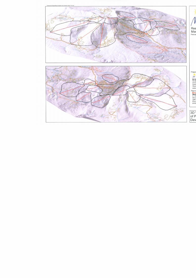
8/12/2019 Mount Baldy
http://slidepdf.com/reader/full/mount-baldy 84/322
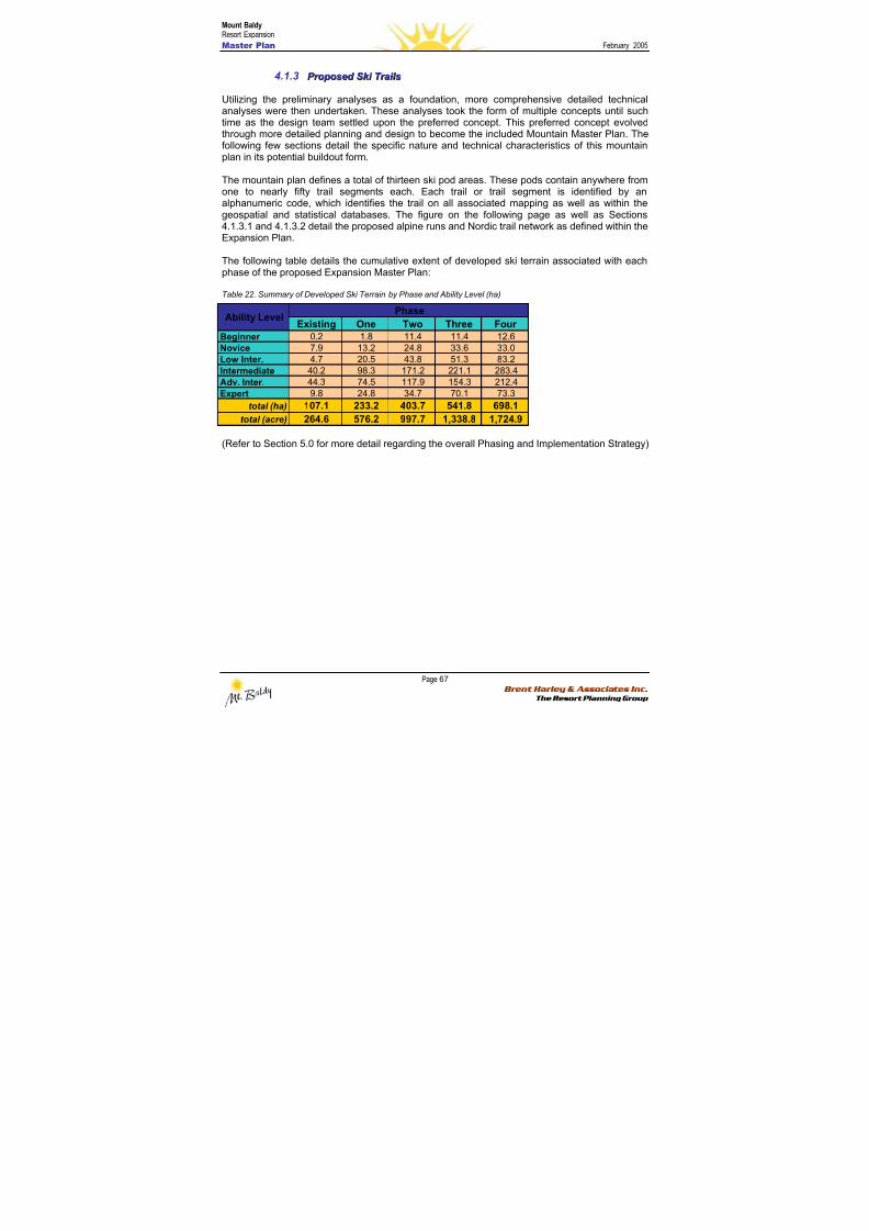
8/12/2019 Mount Baldy
http://slidepdf.com/reader/full/mount-baldy 85/322
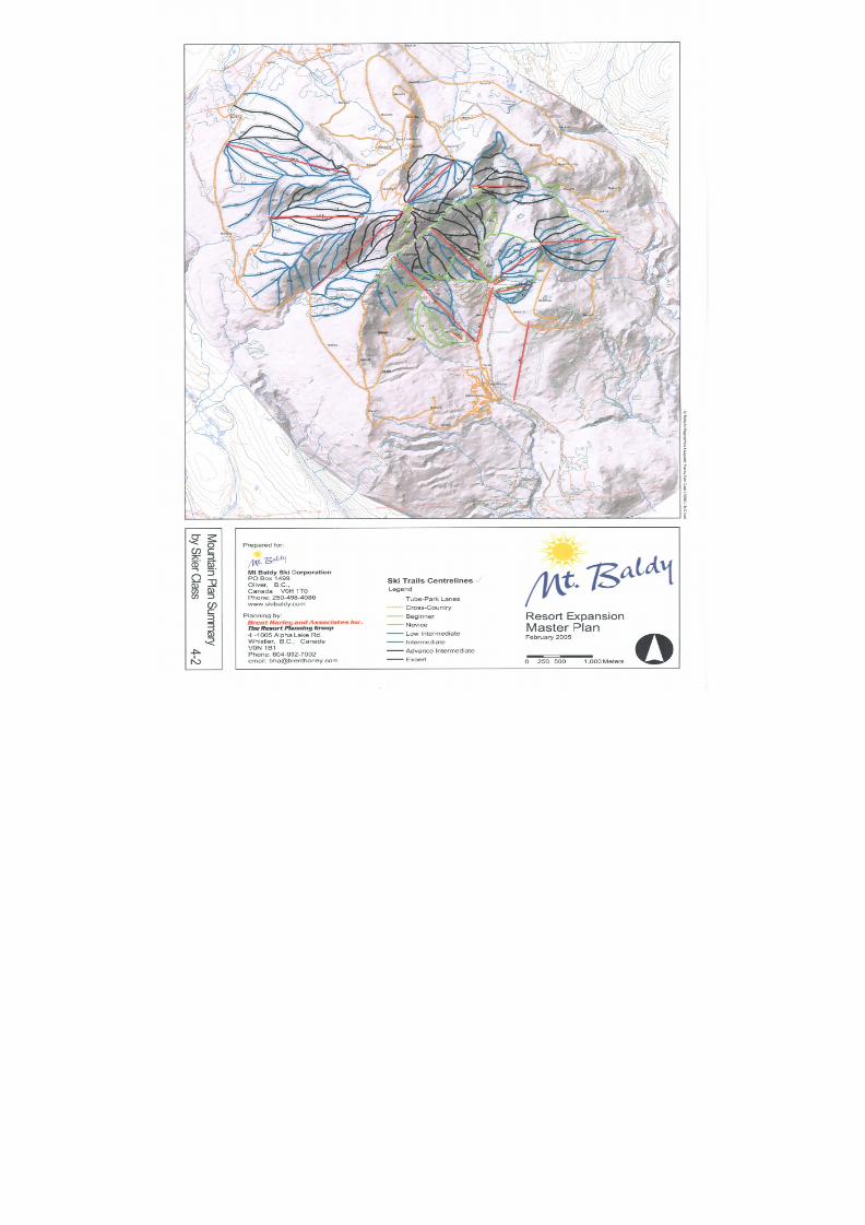
8/12/2019 Mount Baldy
http://slidepdf.com/reader/full/mount-baldy 86/322
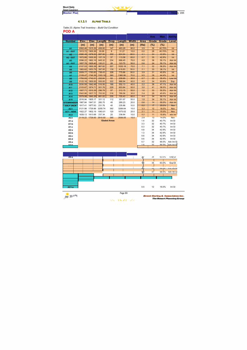
8/12/2019 Mount Baldy
http://slidepdf.com/reader/full/mount-baldy 87/322
Mount BaldyResort Expansion
Master Plan February 2005
Page 69 Brent Harley & Associates Inc.
The Resort Planning Group
44..11..33..11 AALLPPIINNEE TTRRAAIILLSS
Table 23. Alpine Trail Inventory – Build Out Condition
POD A
Run Top Bottom Horiz. Vertical Slope Average Ave. Max. Ability
Number Elev. Elev. Length Drop Length Width Area Grade Grade Level
(m) (m) (m) (m) (m) (m) (Ha) (%) (%)
A1 2062.46 1915.39 458.80 147 483.29 80.0 3.9 32 40.70% Int
A1 - EXT 1913.72 1905.36 30.06 8 31.27 10.0 0.0 28 40.70% Int
A2 2080.48 1878.53 587.90 202 624.94 65.0 4.1 34 42.9% Int
A2 - EXT 1872.66 1835.30 107.19 37 113.58 65.0 0.7 35 42.9% Int
A3 2096.22 1862.16 645.32 234 688.45 70.0 4.8 36 50.1% Adv Int
A3 - EXT 1857.78 1829.40 120.21 28 123.75 50.0 0.6 24 50.1% Adv Int
A4 2107.53 1800.38 967.82 307 1020.18 70.0 7.1 32 56.5% Adv Int
A5 1983.62 1853.79 397.95 130 419.83 50.0 2.1 33 38.1% Int
A6 2009.77 1783.83 738.43 226 775.66 50.0 3.9 31 40.9% Int
A7 2109.47 1749.36 1303.16 360 1360.06 70.0 9.5 28 44.4% Int
A8 1793.93 1742.01 232.84 52 239.69 30.0 0.7 22 30.4% Low IntA9 2122.16 1800.00 935.00 322 988.94 40.0 4.0 34 63.6% Exp
A10 2030.58 1842.48 516.56 188 552.13 40.0 2.2 36 47.1% Adv Int
A11 2103.67 1874.71 551.76 229 603.84 50.0 3.0 41 58.5% Adv Int
A12 1907.71 1810.39 296.78 97 313.15 50.0 1.6 33 50.5% Adv Int
A13 2043.86 1827.72 753.50 216 789.56 30.0 2.4 29 45.6% Adv Int
A14 2079.98 1845.39 681.02 235 725.43 60.0 4.4 34 50.1% Adv Int
A15 2016.94 1905.17 331.12 112 351.67 50.0 1.8 34 50.1% Adv Int
STEMWINDER 1987.84 1947.51 285.70 40 289.23 20.0 0.6 14 50.0% Adv Int
JOLY JACK 1917.41 1877.63 231.76 40 235.86 10.0 0.2 17 25.0% Nov
AC1 2121.98 1729.96 3255.74 392 3289.84 10.0 3.3 12 18.0% Nov
AC1 - NEW 1922.27 1802.19 1063.01 120 1073.02 20.0 2.1 11 15.0% Nov
AC2 1839.13 1813.68 237.34 25 238.84 10.0 0.2 11 10.8% adv Int
AC32119.22 1729.00 2910.00 390 2936.05 10.0 2.9 13 14.0% Nov
A1-a 1.4 32 40.7% Int Gl
A1-b 3.3 32 40.7% Int Gl
A1-c 0.3 32 40.7% Int Gl
A2-a 4.8 34 42.9% Int Gl
A2-b 1.3 34 42.9% Int Gl
A2-c 0.6 34 42.9% Int Gl
A2-d 0.6 34 42.9% Int Gl
A4-a 0.7 32 56.5% Adv Int Gl
A4-b 1.6 32 56.5% Adv Int Gl
A4-c 3.4 32 56.5% Adv Int Gl
A5-a 1.1 33 38.0% Int Gl
A7-a 1.1 28 44.0% Int Gl
A9-a 2.7 34 63.0% Exp Gl
A9-b 2.3 34 63.0% Exp Gl
A9-c 1.4 34 63.0% Exp Gl
A10-a 1.2 36 47.0% Adv Int Gl
A11-a 0.1 41 58.5% Adv Int Gl
A11-b 5.0 41 58.5% Adv Int Gl
A13-a 3.2 29 45.6% Adv Int Gl
A14-a 6.2 34 50.1% Adv Int Gl
A15-a 2.4 34 50.1% Adv Int Gl
A15-b 2.4 34 50.0% Adv Int Gl
AC1-a
Gladed Areas
0.5 12 18.0% Int Gl
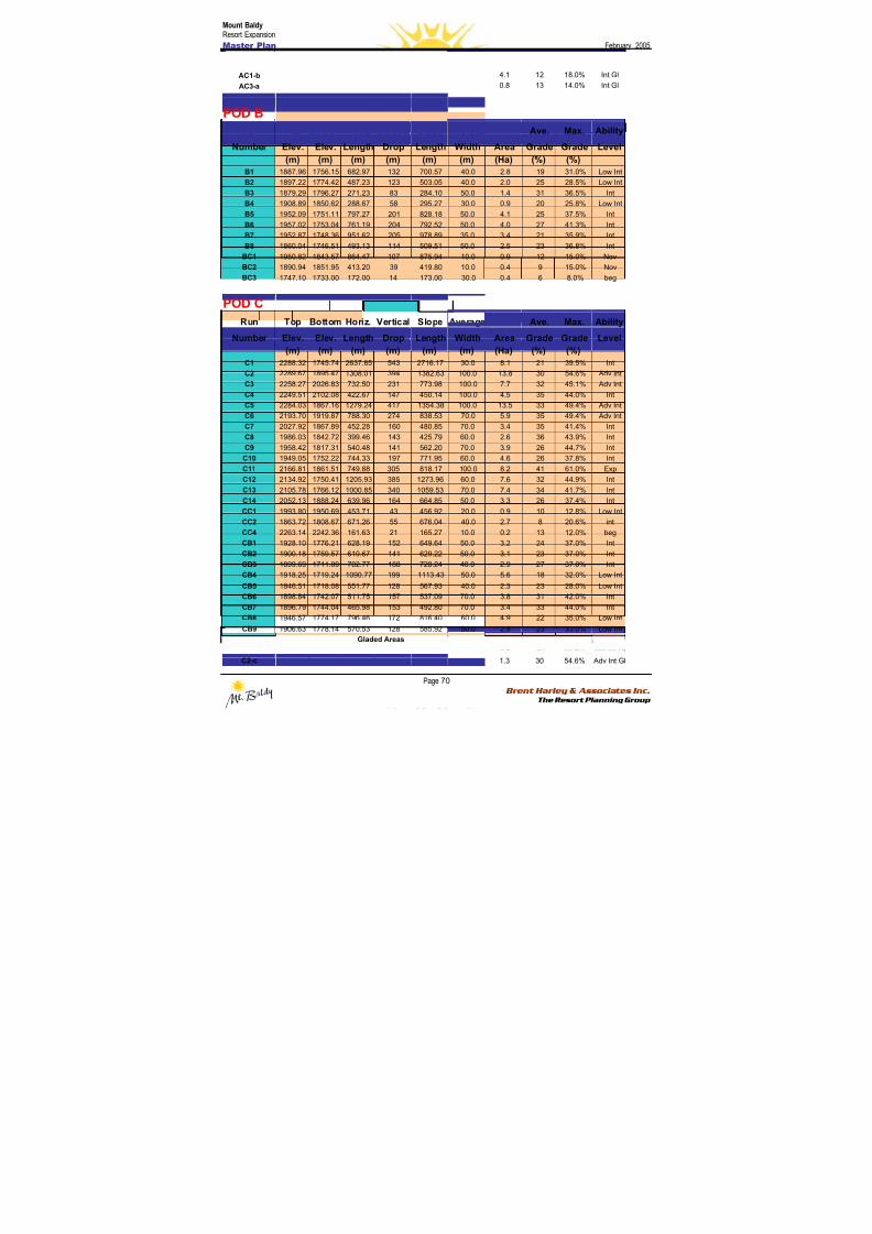
8/12/2019 Mount Baldy
http://slidepdf.com/reader/full/mount-baldy 88/322
Mount BaldyResort Expansion
Master Plan February 2005
Page 70 Brent Harley & Associates Inc.
The Resort Planning Group
AC1-b 4.1 12 18.0% Int Gl
AC3-a 0.8 13 14.0% Int Gl
POD B
Run Top Bottom Horiz. Vertical Slope Average Ave. Max. Ability
Number Elev. Elev. Length Drop Length Width Area Grade Grade Level
(m) (m) (m) (m) (m) (m) (Ha) (%) (%)
B1 1887.96 1756.15 682.97 132 700.57 40.0 2.8 19 31.0% Low Int
B2 1897.22 1774.42 487.23 123 503.05 40.0 2.0 25 28.5% Low Int
B3 1879.29 1796.27 271.23 83 284.10 50.0 1.4 31 36.5% Int
B4 1908.89 1850.62 288.67 58 295.27 30.0 0.9 20 25.8% Low Int
B5 1952.09 1751.11 797.27 201 828.18 50.0 4.1 25 37.5% Int
B6 1957.02 1753.04 761.19 204 792.52 50.0 4.0 27 41.3% Int
B7 1952.87 1748.36 951.62 205 978.89 35.0 3.4 21 35.9% Int
B8 1860.04 1746.51 493.13 114 509.51 50.0 2.5 23 36.8% Int
BC1 1950.82 1843.57 864.47 107 875.94 10.0 0.9 12 15.0% Nov
BC2 1890.94 1851.95 413.20 39 419.80 10.0 0.4 9 15.0% Nov
BC3 1747.10 1733.00 172.00 14 173.00 30.0 0.4 6 8.0% beg
POD C
Run Top Bottom Horiz. Vertical Slope Average Ave. Max. Ability
Number Elev. Elev. Length Drop Length Width Area Grade Grade Level
(m) (m) (m) (m) (m) (m) (Ha) (%) (%)
C1 2288.32 1745.74 2637.85 543 2716.17 30.0 8.1 21 39.5% Int
C2 2289.67 1895.47 1308.01 394 1382.63 100.0 13.8 30 54.6% Adv Int
C3 2258.27 2026.83 732.50 231 773.98 100.0 7.7 32 45.1% Adv Int
C4 2249.51 2102.08 422.67 147 450.14 100.0 4.5 35 44.0% Int
C5 2284.03 1867.16 1279.24 417 1354.38 100.0 13.5 33 49.4% Adv Int
C6 2193.70 1919.87 788.30 274 838.53 70.0 5.9 35 49.4% Adv IntC7 2027.92 1867.89 452.28 160 480.85 70.0 3.4 35 41.4% Int
C8 1986.03 1842.72 399.46 143 425.79 60.0 2.6 36 43.9% Int
C9 1958.42 1817.31 540.48 141 562.20 70.0 3.9 26 44.7% Int
C10 1949.05 1752.22 744.33 197 771.95 60.0 4.6 26 37.8% Int
C11 2166.81 1861.51 749.88 305 818.17 100.0 8.2 41 61.0% Exp
C12 2134.92 1750.41 1205.93 385 1273.96 60.0 7.6 32 44.9% Int
C13 2105.78 1766.12 1000.85 340 1059.53 70.0 7.4 34 41.7% Int
C14 2052.13 1888.24 639.96 164 664.85 50.0 3.3 26 37.4% Int
CC1 1993.80 1950.69 453.71 43 456.92 20.0 0.9 10 12.8% Low Int
CC2 1863.72 1808.67 671.26 55 676.04 40.0 2.7 8 20.6% int
CC4 2263.14 2242.36 161.63 21 165.27 10.0 0.2 13 12.0% beg
CB1 1928.10 1776.21 628.19 152 649.64 50.0 3.2 24 37.0% Int
CB2 1900.18 1759.57 610.67 141 629.22 50.0 3.1 23 37.0% Int
CB3 1899.69 1711.89 702.77 188 728.24 40.0 2.9 27 37.0% Int
CB4 1918.25 1719.24 1090.77 199 1113.43 50.0 5.6 18 32.0% Low Int
CB5 1846.51 1718.08 551.77 128 567.93 40.0 2.3 23 28.0% Low Int
CB6 1898.84 1742.07 511.75 157 537.09 70.0 3.8 31 42.0% Int
CB7 1896.79 1744.04 465.98 153 492.80 70.0 3.4 33 44.0% Int
CB8 1946.57 1774.17 796.46 172 816.40 60.0 4.9 22 35.0% Low Int
CB9 1906.63 1778.14 570.53 128 585.92 50.0 2.9 23 33.0% Low Int
C2-a 0.8 30 54.6% Adv Int Gl
C2-b 0.9 30 54.6% Adv Int Gl
C2-c
Gladed Areas
1.3 30 54.6% Adv Int Gl
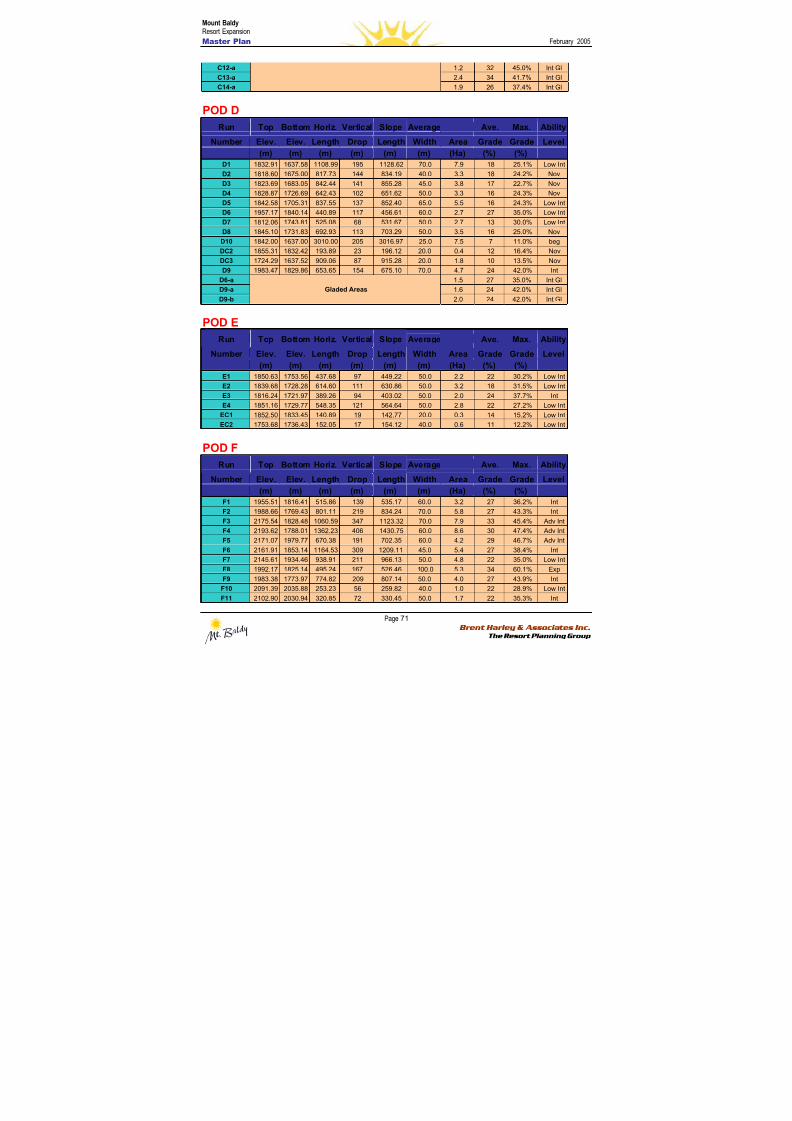
8/12/2019 Mount Baldy
http://slidepdf.com/reader/full/mount-baldy 89/322
Mount BaldyResort Expansion
Master Plan February 2005
Page 71 Brent Harley & Associates Inc.
The Resort Planning Group
C12-a 1.2 32 45.0% Int Gl
C13-a 2.4 34 41.7% Int Gl
C14-a 1.9 26 37.4% Int Gl
POD D
Run Top Bottom Horiz. Vertical Slope Average Ave. Max. Ability
Number Elev. Elev. Length Drop Length Width Area Grade Grade Level
(m) (m) (m) (m) (m) (m) (Ha) (%) (%)
D1 1832.91 1637.58 1108.99 195 1128.62 70.0 7.9 18 25.1% Low Int
D2 1818.60 1675.00 817.73 144 834.19 40.0 3.3 18 24.2% Nov
D3 1823.69 1683.05 842.44 141 855.28 45.0 3.8 17 22.7% Nov
D4 1828.87 1726.69 642.43 102 651.62 50.0 3.3 16 24.3% Nov
D5 1842.58 1705.31 837.55 137 852.40 65.0 5.5 16 24.3% Low Int
D6 1957.17 1840.14 440.89 117 456.61 60.0 2.7 27 35.0% Low Int
D7 1812.06 1743.81 525.08 68 531.67 50.0 2.7 13 30.0% Low Int
D8 1845.10 1731.83 692.93 113 703.29 50.0 3.5 16 25.0% Nov
D10 1842.00 1637.00 3010.00 205 3016.97 25.0 7.5 7 11.0% beg
DC2 1855.31 1832.42 193.89 23 196.12 20.0 0.4 12 16.4% NovDC3 1724.29 1637.52 909.06 87 915.28 20.0 1.8 10 13.5% Nov
D9 1983.47 1829.86 653.65 154 675.10 70.0 4.7 24 42.0% Int
D6-a 1.5 27 35.0% Int Gl
D9-a 1.6 24 42.0% Int Gl
D9-b
Gladed Areas
2.0 24 42.0% Int Gl
POD E
Run Top Bottom Horiz. Vertical Slope Average Ave. Max. Ability
Number Elev. Elev. Length Drop Length Width Area Grade Grade Level
(m) (m) (m) (m) (m) (m) (Ha) (%) (%)
E1 1850.63 1753.56 437.68 97 449.22 50.0 2.2 22 30.2% Low Int
E2 1839.68 1728.28 614.60 111 630.86 50.0 3.2 18 31.5% Low Int
E3 1816.24 1721.97 389.26 94 403.02 50.0 2.0 24 37.7% Int
E4 1851.16 1729.77 548.35 121 564.64 50.0 2.8 22 27.2% Low Int
EC1 1852.50 1833.45 140.89 19 142.77 20.0 0.3 14 15.2% Low Int
EC2 1753.68 1736.43 152.05 17 154.12 40.0 0.6 11 12.2% Low Int
POD F
Run Top Bottom Horiz. Vertical Slope Average Ave. Max. Ability
Number Elev. Elev. Length Drop Length Width Area Grade Grade Level
(m) (m) (m) (m) (m) (m) (Ha) (%) (%)
F1 1955.51 1816.41 515.86 139 535.17 60.0 3.2 27 36.2% Int
F2 1988.66 1769.43 801.11 219 834.24 70.0 5.8 27 43.3% Int
F3 2175.54 1828.48 1060.59 347 1123.32 70.0 7.9 33 45.4% Adv Int
F4 2193.62 1788.01 1362.23 406 1430.75 60.0 8.6 30 47.4% Adv Int
F5 2171.07 1979.77 670.38 191 702.35 60.0 4.2 29 46.7% Adv Int
F6 2161.91 1853.14 1164.53 309 1209.11 45.0 5.4 27 38.4% Int
F7 2145.61 1934.46 938.91 211 966.13 50.0 4.8 22 35.0% Low Int
F8 1992.17 1825.14 495.24 167 526.46 100.0 5.3 34 60.1% Exp
F9 1983.38 1773.97 774.82 209 807.14 50.0 4.0 27 43.9% Int
F10 2091.39 2035.88 253.23 56 259.82 40.0 1.0 22 28.9% Low Int
F11 2102.90 2030.94 320.85 72 330.45 50.0 1.7 22 35.3% Int
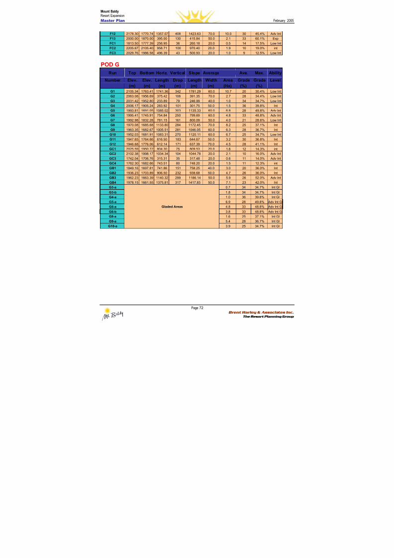
8/12/2019 Mount Baldy
http://slidepdf.com/reader/full/mount-baldy 90/322
Mount BaldyResort Expansion
Master Plan February 2005
Page 72 Brent Harley & Associates Inc.
The Resort Planning Group
F12 2178.30 1770.74 1357.07 408 1423.63 70.0 10.0 30 45.4% Adv Int
F13 2000.00 1870.00 395.00 130 415.84 50.0 2.1 33 60.1% Exp
FC1 1813.50 1777.39 256.95 36 260.18 20.0 0.5 14 17.5% Low Int
FC2 2205.67 2105.40 958.71 100 970.40 20.0 1.9 10 19.0% int
FC3 2029.76 1986.58 496.39 43 500.93 20.0 1.0 9 12.5% Low Int
POD GRun Top Bottom Horiz. Vertical Slope Average Ave. Max. Ability
Number Elev. Elev. Length Drop Length Width Area Grade Grade Level
(m) (m) (m) (m) (m) (m) (Ha) (%) (%)
G1 2105.34 1763.41 1741.36 342 1781.29 60.0 10.7 20 30.4% Low Int
G2 2063.08 1956.69 375.42 106 391.35 70.0 2.7 28 34.4% Low Int
G3 2031.42 1952.80 233.89 79 246.99 40.0 1.0 34 34.7% Low Int
G4 2006.17 1905.24 283.92 101 301.75 50.0 1.5 36 39.8% Int
G5 1993.81 1691.05 1085.02 303 1135.33 60.0 6.8 28 49.8% Adv Int
G6 1995.41 1745.91 754.84 250 799.69 60.0 4.8 33 48.8% Adv Int
G7 1992.98 1832.28 781.15 161 800.09 50.0 4.0 21 28.6% Low Int
G8 1970.08 1685.68 1133.80 284 1172.45 70.0 8.2 25 37.1% IntG9 1963.35 1682.67 1005.51 281 1046.05 60.0 6.3 28 36.7% Int
G10 1952.03 1681.91 1083.31 270 1120.11 60.0 6.7 25 34.7% Low Int
G11 1947.65 1764.66 616.50 183 644.67 50.0 3.2 30 36.8% Int
G12 1946.68 1776.06 612.14 171 637.39 70.0 4.5 28 41.1% Int
GC1 2025.59 1950.72 804.30 75 809.53 20.0 1.6 12 14.3% int
GC2 2102.38 1998.17 1034.34 104 1044.78 20.0 2.1 10 16.0% Adv Int
GC3 1742.04 1706.76 315.31 35 317.48 20.0 0.6 11 14.0% Adv Int
GC4 1762.30 1682.66 743.51 80 748.20 20.0 1.5 11 12.3% int
GB1 1849.16 1697.81 741.86 151 758.25 40.0 3.0 20 36.0% Int
GB2 1936.23 1703.89 906.50 232 938.68 50.0 4.7 26 36.0% Int
GB3 1962.23 1663.39 1140.32 299 1186.14 50.0 5.9 26 52.0% Adv Int
GB4 1978.15 1661.55 1375.81 317 1417.83 50.0 7.1 23 42.0% Int
G3-a 0.7 34 34.7% Int Gl
G3-b 1.8 34 34.7% Int Gl
G4-a 1.0 36 39.8% Int Gl
G5-a 6.9 28 49.8% Adv Int Gl
G6-a 4.8 33 48.8% Adv Int Gl
G6-b 3.8 33 48.8% Adv Int Gl
G8-a 1.6 25 37.1% Int Gl
G9-a 5.4 28 36.7% Int Gl
G10-a
Gladed Areas
3.9 25 34.7% Int Gl
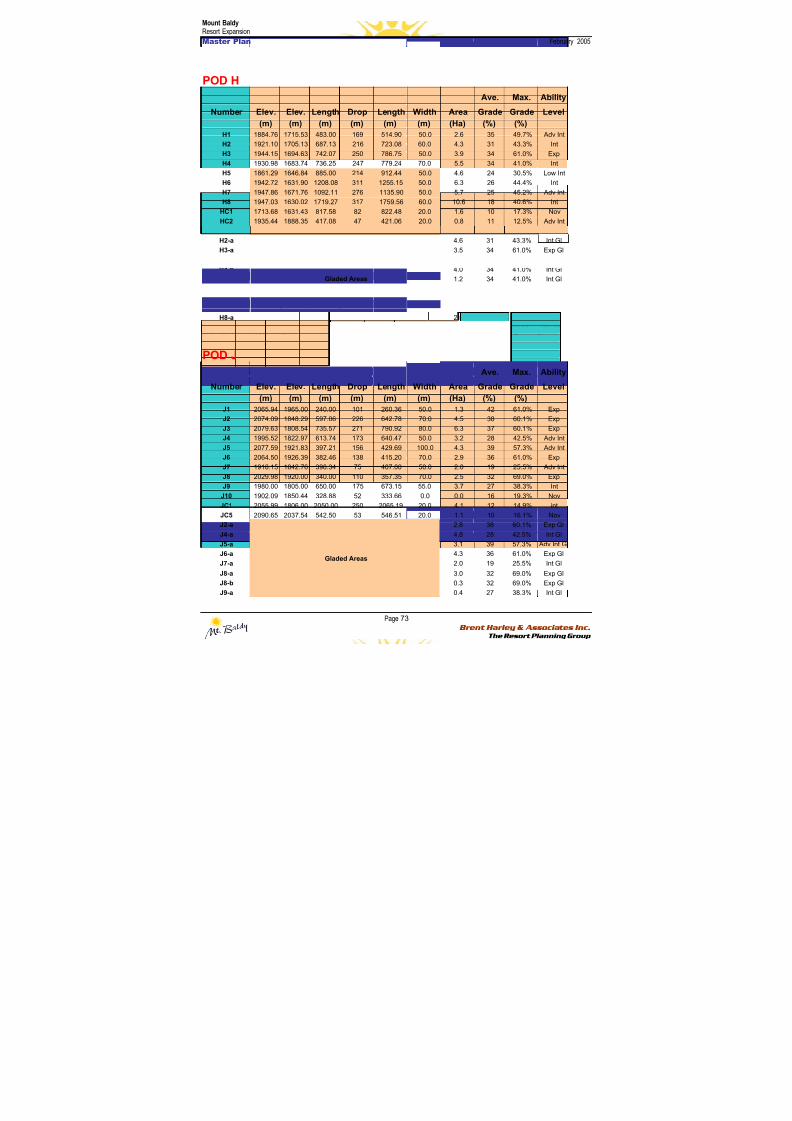
8/12/2019 Mount Baldy
http://slidepdf.com/reader/full/mount-baldy 91/322
Mount BaldyResort Expansion
Master Plan February 2005
Page 73 Brent Harley & Associates Inc.
The Resort Planning Group
POD H
Run Top Bottom Horiz. Vertical Slope Average Ave. Max. Ability
Number Elev. Elev. Length Drop Length Width Area Grade Grade Level
(m) (m) (m) (m) (m) (m) (Ha) (%) (%)H1 1884.76 1715.53 483.00 169 514.90 50.0 2.6 35 49.7% Adv Int
H2 1921.10 1705.13 687.13 216 723.08 60.0 4.3 31 43.3% Int
H3 1944.15 1694.63 742.07 250 786.75 50.0 3.9 34 61.0% Exp
H4 1930.98 1683.74 736.25 247 779.24 70.0 5.5 34 41.0% Int
H5 1861.29 1646.84 885.00 214 912.44 50.0 4.6 24 30.5% Low Int
H6 1942.72 1631.90 1208.08 311 1255.15 50.0 6.3 26 44.4% Int
H7 1947.86 1671.76 1092.11 276 1135.90 50.0 5.7 25 45.2% Adv Int
H8 1947.03 1630.02 1719.27 317 1759.56 60.0 10.6 18 40.6% Int
HC1 1713.68 1631.43 817.58 82 822.48 20.0 1.6 10 17.3% Nov
HC2 1935.44 1888.35 417.08 47 421.06 20.0 0.8 11 12.5% Adv Int
H1-a 2.1 35 49.7% Adv Int Gl
H2-a 4.6 31 43.3% Int Gl
H3-a 3.5 34 61.0% Exp GlH4-a 0.1 34 41.0% Int Gl
H4-b 4.0 34 41.0% Int Gl
H4-c 1.2 34 41.0% Int Gl
H5-a 1.8 24 30.5% Int Gl
H6-a 3.2 26 44.4% Int Gl
H7-a 2.8 25 45.2% Adv Int Gl
H8-a 2.5 18 40.6% Adv Int Gl
H8-b
Gladed Areas
3.3 18 40.6% Adv Int Gl
Note: There is no “i” Pod – this is a simple mapping convenience to avoid misinterpreting the letter “i”’ with the number one.
POD J
Run Top Bottom Horiz. Vertical Slope Average Ave. Max. Ability
Number Elev. Elev. Length Drop Length Width Area Grade Grade Level
(m) (m) (m) (m) (m) (m) (Ha) (%) (%)
J1 2065.94 1965.00 240.00 101 260.36 50.0 1.3 42 61.0% Exp
J2 2074.09 1848.29 597.06 226 642.78 70.0 4.5 38 60.1% Exp
J3 2079.63 1808.54 735.57 271 790.92 80.0 6.3 37 60.1% Exp
J4 1995.52 1822.97 613.74 173 640.47 50.0 3.2 28 42.5% Adv Int
J5 2077.59 1921.83 397.21 156 429.69 100.0 4.3 39 57.3% Adv Int
J6 2064.50 1926.39 382.46 138 415.20 70.0 2.9 36 61.0% Exp
J7 1918.15 1842.76 398.34 75 407.00 50.0 2.0 19 25.5% Adv Int
J8 2029.98 1920.00 340.00 110 357.35 70.0 2.5 32 69.0% Exp
J9 1980.00 1805.00 650.00 175 673.15 55.0 3.7 27 38.3% Int
J10 1902.09 1850.44 328.88 52 333.66 0.0 0.0 16 19.3% Nov
JC1 2055.99 1806.00 2050.00 250 2065.19 20.0 4.1 12 14.9% intJC5 2090.65 2037.54 542.50 53 546.51 20.0 1.1 10 16.1% Nov
J2-a 2.8 38 60.1% Exp Gl
J4-a 4.8 28 42.5% Int Gl
J5-a 3.1 39 57.3% Adv Int Gl
J6-a 4.3 36 61.0% Exp Gl
J7-a 2.0 19 25.5% Int Gl
J8-a 3.0 32 69.0% Exp Gl
J8-b 0.3 32 69.0% Exp Gl
J9-a
Gladed Areas
0.4 27 38.3% Int Gl
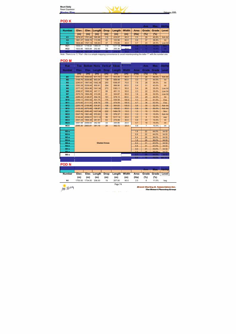
8/12/2019 Mount Baldy
http://slidepdf.com/reader/full/mount-baldy 92/322
Mount BaldyResort Expansion
Master Plan February 2005
Page 74 Brent Harley & Associates Inc.
The Resort Planning Group
POD K
Run Top Bottom Horiz. Vertical Slope Average Ave. Max. Ability
Number Elev. Elev. Length Drop Length Width Area Grade Grade Level
(m) (m) (m) (m) (m) (m) (Ha) (%) (%)
K1 1876.57 1761.44 395.88 115 416.67 60.0 2.5 29 45.8% Adv IntK2 1881.27 1838.74 113.99 43 122.56 50.0 0.6 37 38.8% Int
K3 1804.46 1767.13 165.83 37 170.89 40.0 0.7 23 28.5% Low Int
KC1 1836.61 1718.02 1365.91 119 1377.58 20.0 2.8 9 19.0% Nov
KC2 1833.66 1805.69 252.80 28 255.36 20.0 0.5 11 15.8% int
KC3 1893.04 1877.24 216.57 16 218.70 20.0 0.4 7 12.4% Adv Int
Note: There is no “L” Pod – this is a simple mapping convenience to avoid misinterpreting the letter “l”’ with the number one.
POD M
Run Top Bottom Horiz. Vertical Slope Average Ave. Max. Ability
Number Elev. Elev. Length Drop Length Width Area Grade Grade Level
(m) (m) (m) (m) (m) (m) (Ha) (%) (%)
M1 2291.15 2050.62 871.70 241 912.28 80.0 7.3 28 49.0% Adv Int
M2 2165.70 2026.66 643.24 139 659.48 50.0 3.3 22 44.0% Int
M3 2290.81 1997.64 1042.38 293 1090.97 70.0 7.6 28 36.0% Int
M4 2292.28 2028.64 850.81 264 896.90 60.0 5.4 31 43.0% Int
M5 2277.43 2004.86 1041.94 273 1083.11 50.0 5.4 26 35.0% Low Int
M6 2096.57 1998.04 447.17 99 461.13 50.0 2.3 22 35.0% Low Int
M7 2075.74 1994.29 313.28 81 324.87 50.0 1.6 26 32.0% Low Int
M8 2289.23 2128.07 554.18 161 579.13 60.0 3.5 29 44.0% Int
M10 2269.11 2093.54 501.75 176 536.58 100.0 5.4 35 61.0% Exp
M11 2270.60 2111.51 436.74 159 474.09 100.0 4.7 36 62.0% Exp
M12 2265.18 2106.86 534.87 158 564.83 100.0 5.6 30 52.0% Adv Int
M13 2133.33 2073.65 156.87 60 169.62 50.0 0.8 38 50.0% Adv Int
MC1 2302.45 2080.49 1437.84 222 1464.78 10.0 1.5 15 15.0% Nov
MC2 2047.78 1991.48 572.63 56 576.37 20.0 1.2 10 15.0% Adv Int
MC3 2144.44 2058.51 1011.12 86 1017.14 20.0 2.0 8 15.0% exp
MC4 2057.23 1994.34 261.91 63 270.46 30.0 0.8 24 15.0% int
MC5 2091.58 2058.63 342.59 33 344.86 20.0 0.7 10 15.0% int
MC6 2090.30 2063.81 381.16 26 382.72 20.0 0.8 7 15.0% int
M1-a 1.6 28 49.0% Adv Int Gl
M2-a 1.8 22 44.0% Int Gl
M2-b 0.9 22 44.0% Int Gl
M3-a 0.4 28 36.0% Int Gl
M3-b 1.8 28 36.0% Int Gl
M4-a 0.2 31 43.0% Int Gl
M4-b 0.8 31 43.0% Int Gl
M4-c 3.0 31 43.0% Int Gl
M5-a 2.3 26 35.0% Int Gl
M8-a 2.7 29 44.0% Int Gl
MC2-a
Gladed Areas
0.9 10 15.0% Adv Int Gl
POD N
Run Top Bottom Horiz. Vertical Slope Average Ave. Max. Ability
Number Elev. Elev. Length Drop Length Width Area Grade Grade Level
(m) (m) (m) (m) (m) (m) (Ha) (%) (%)
N1 1753.00 1734.00 206.00 19 207.00 60.0 2.5 8 11.0% beg
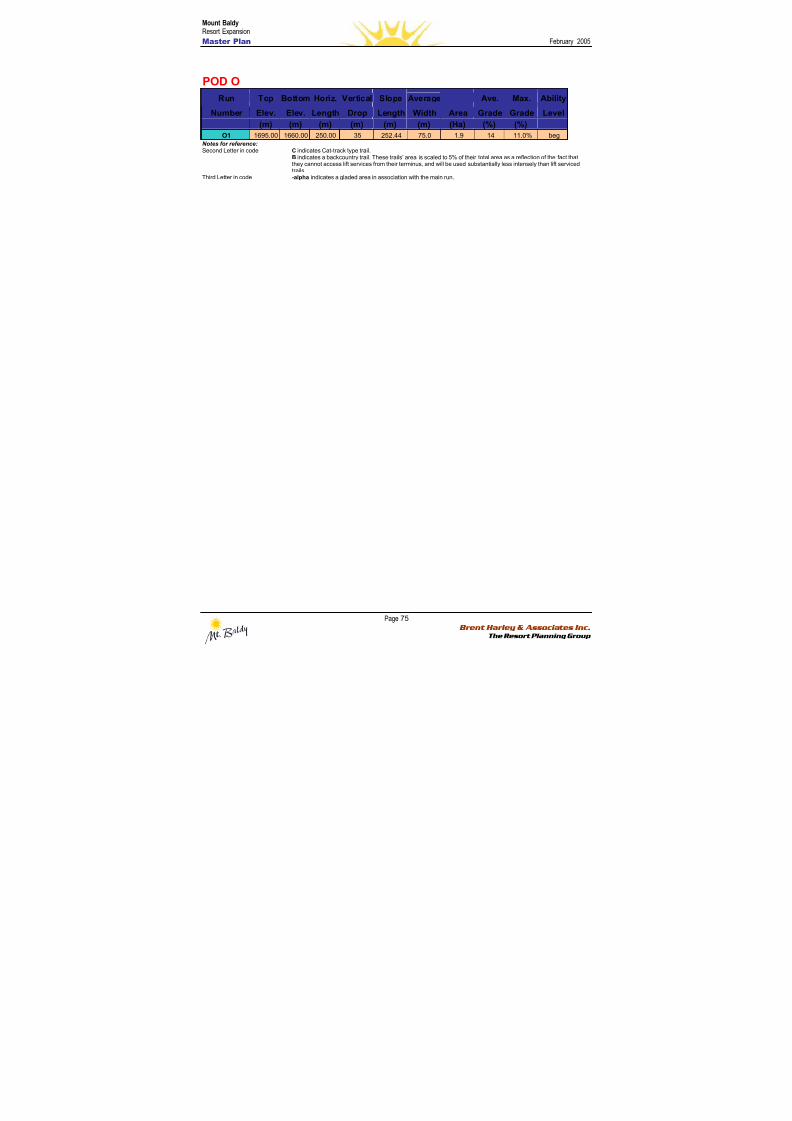
8/12/2019 Mount Baldy
http://slidepdf.com/reader/full/mount-baldy 93/322
Mount BaldyResort Expansion
Master Plan February 2005
Page 75 Brent Harley & Associates Inc.
The Resort Planning Group
POD O
Run Top Bottom Horiz. Vertical Slope Average Ave. Max. Ability
Number Elev. Elev. Length Drop Length Width Area Grade Grade Level
(m) (m) (m) (m) (m) (m) (Ha) (%) (%)O1 1695.00 1660.00 250.00 35 252.44 75.0 1.9 14 11.0% beg
Notes for reference:Second Letter in code C indicates Cat-track type trail.
B indicates a backcountry trail. These trails’ area is scaled to 5% of their total area as a reflection of the fact thatthey cannot access lift services from their terminus, and will be used substantially less intensely than lift servicedtrails.
Third Letter in code -alpha indicates a gladed area in association with the main run.
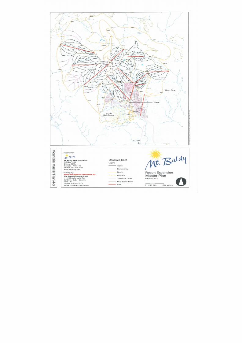
8/12/2019 Mount Baldy
http://slidepdf.com/reader/full/mount-baldy 94/322
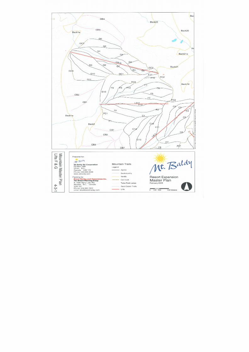
8/12/2019 Mount Baldy
http://slidepdf.com/reader/full/mount-baldy 95/322
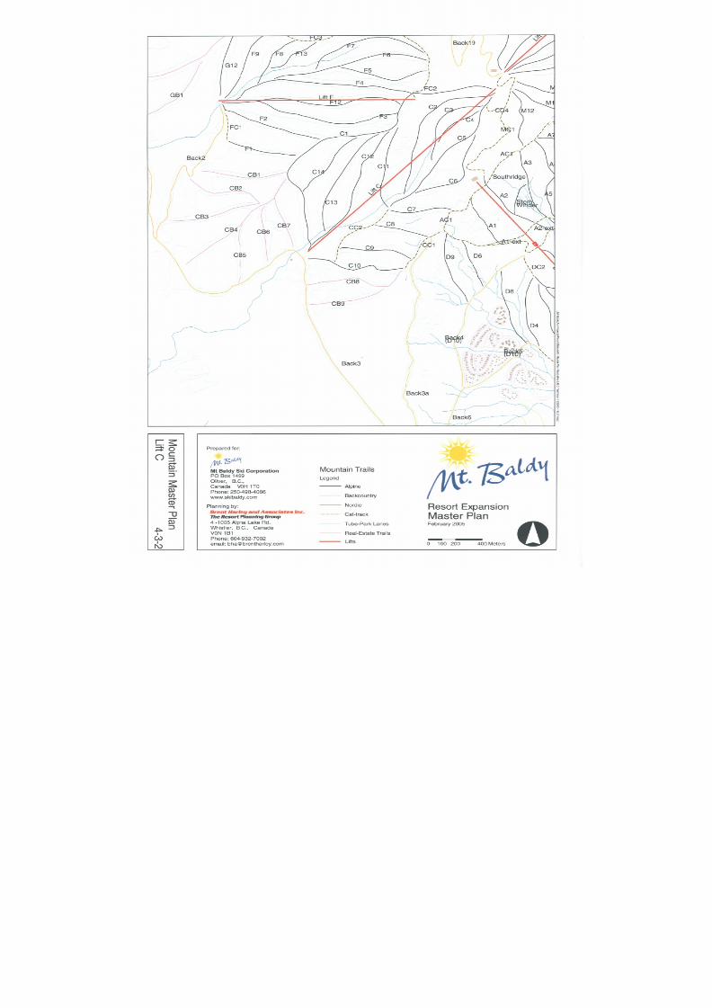
8/12/2019 Mount Baldy
http://slidepdf.com/reader/full/mount-baldy 96/322
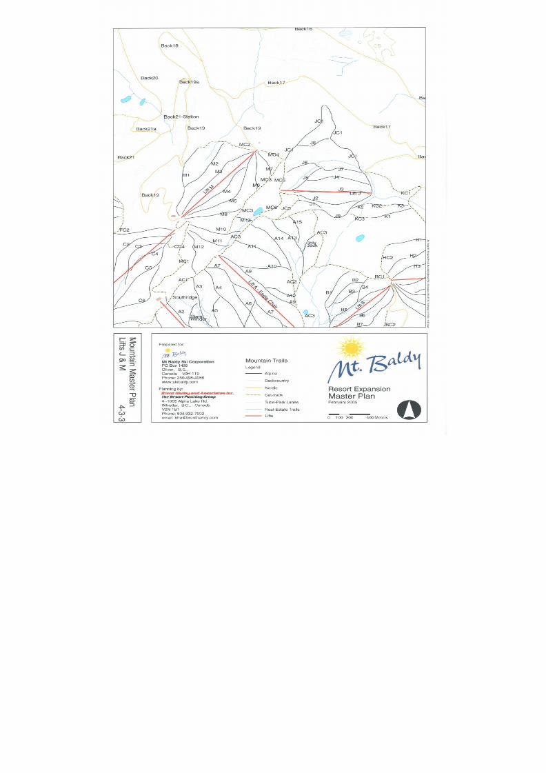
8/12/2019 Mount Baldy
http://slidepdf.com/reader/full/mount-baldy 97/322
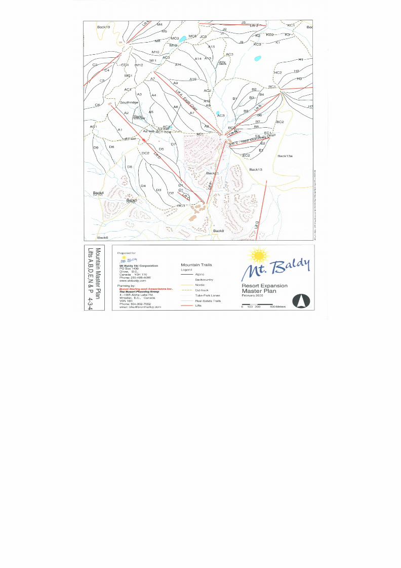
8/12/2019 Mount Baldy
http://slidepdf.com/reader/full/mount-baldy 98/322
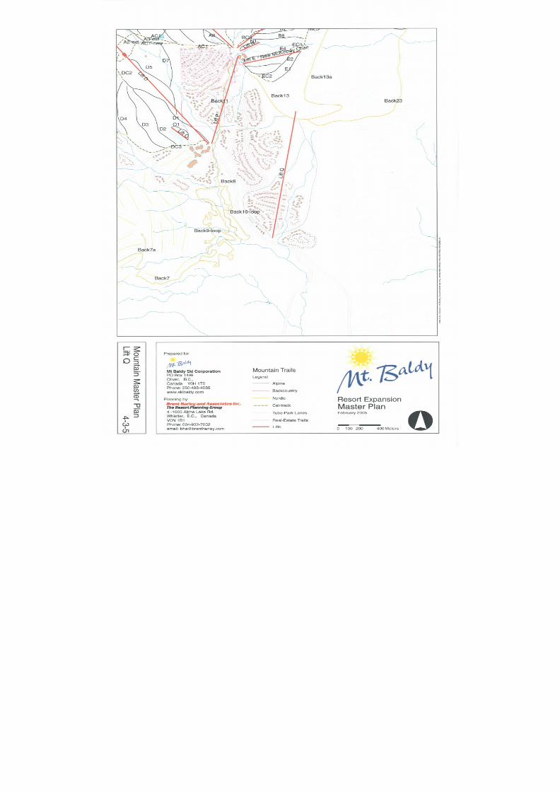
8/12/2019 Mount Baldy
http://slidepdf.com/reader/full/mount-baldy 99/322
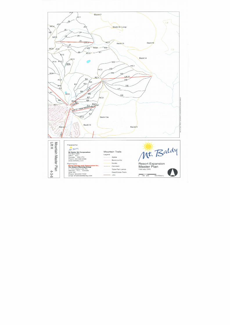
8/12/2019 Mount Baldy
http://slidepdf.com/reader/full/mount-baldy 100/322
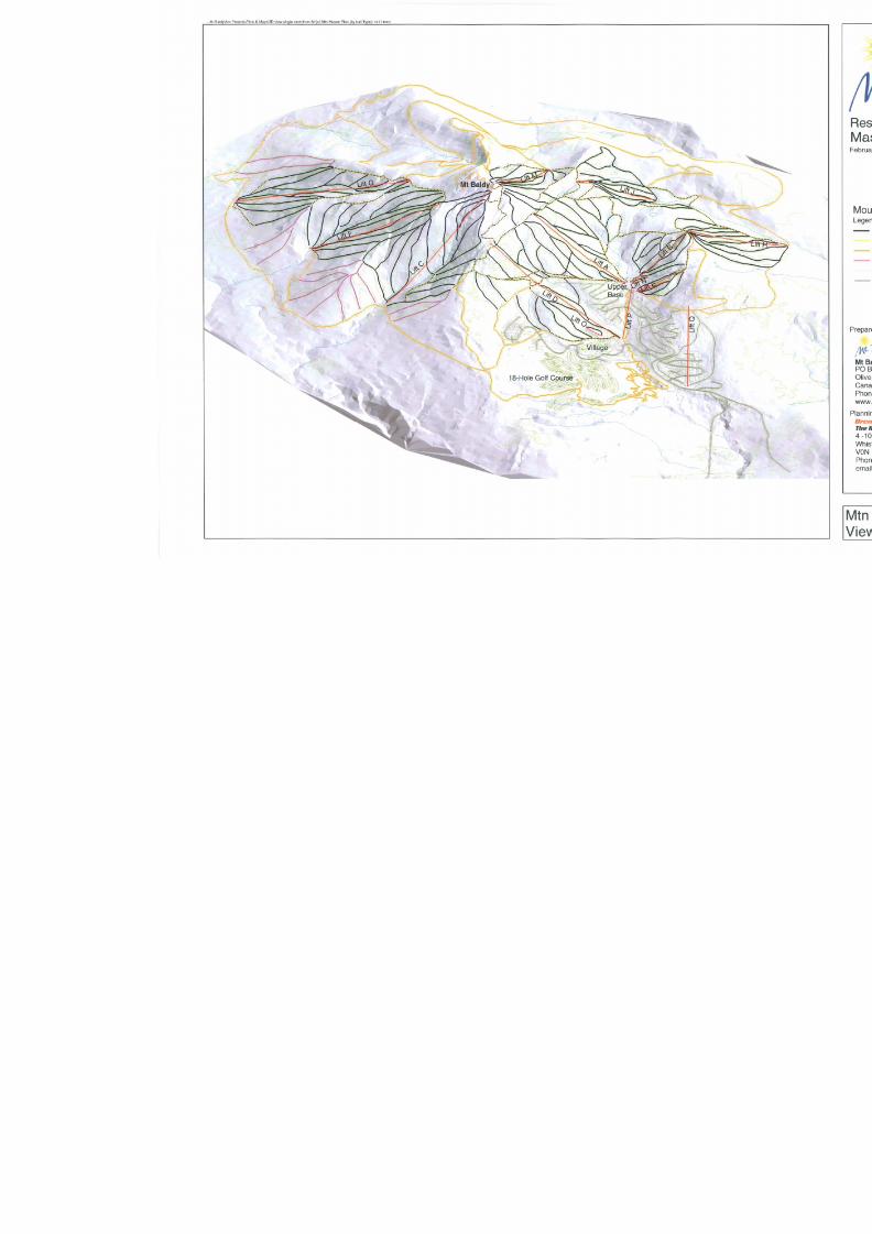
8/12/2019 Mount Baldy
http://slidepdf.com/reader/full/mount-baldy 101/322

8/12/2019 Mount Baldy
http://slidepdf.com/reader/full/mount-baldy 102/322

8/12/2019 Mount Baldy
http://slidepdf.com/reader/full/mount-baldy 103/322
Mount BaldyResort Expansion
Master Plan February 2005
Page 85 Brent Harley & Associates Inc.
The Resort Planning Group
44..11..33..22 NNOORRDDIICC TTRRAAIILLSS
Central to the Mountain Plan’s unique character is the fact that Nordic trails have been included,not only within the study area, but rather throughout the Alpine skiing area. In fact, it is the intentof this plan to have Nordic skiers accessing the same heights of land as the alpine skiers, withboth skier types using the ski lifts. The phased Nordic trail development plan has been designedso that Nordic skiers will enjoy the freedom of Nordic exclusive trails around the periphery of themountain, however they will also be able to access higher elevation terrain by boarding thealpine lift infrastructure. From the top of any Nordic accessible lift, the Nordic skiers will alwayshave a means of returning to the lower elevation cross-country trails via a shallow grade returntrail (less than 12%). This attribute of the trail plan is totally unique, and is only made possibledue to the particularly opportune nature of the mountain terrain – specifically the accessibility ofshallow terrain, and the near complete lack of high angle mountain features.
In North America, Royal Gorge is the only other Nordic Resort that utilizes ski lifts for cross-country skiing
As with all aspects of the Plan, the phased nature of the development process is key to thelong-term success of the facility. The Nordic trail network is ambitious in scope and character,but has also been designed to ensure that it provides a balanced and complete product at allphases defined within the evolution of the Master Plan.
The following table details the specific length and associated capacity of the dedicated Nordictrail network illustrated on Figure 4-2.
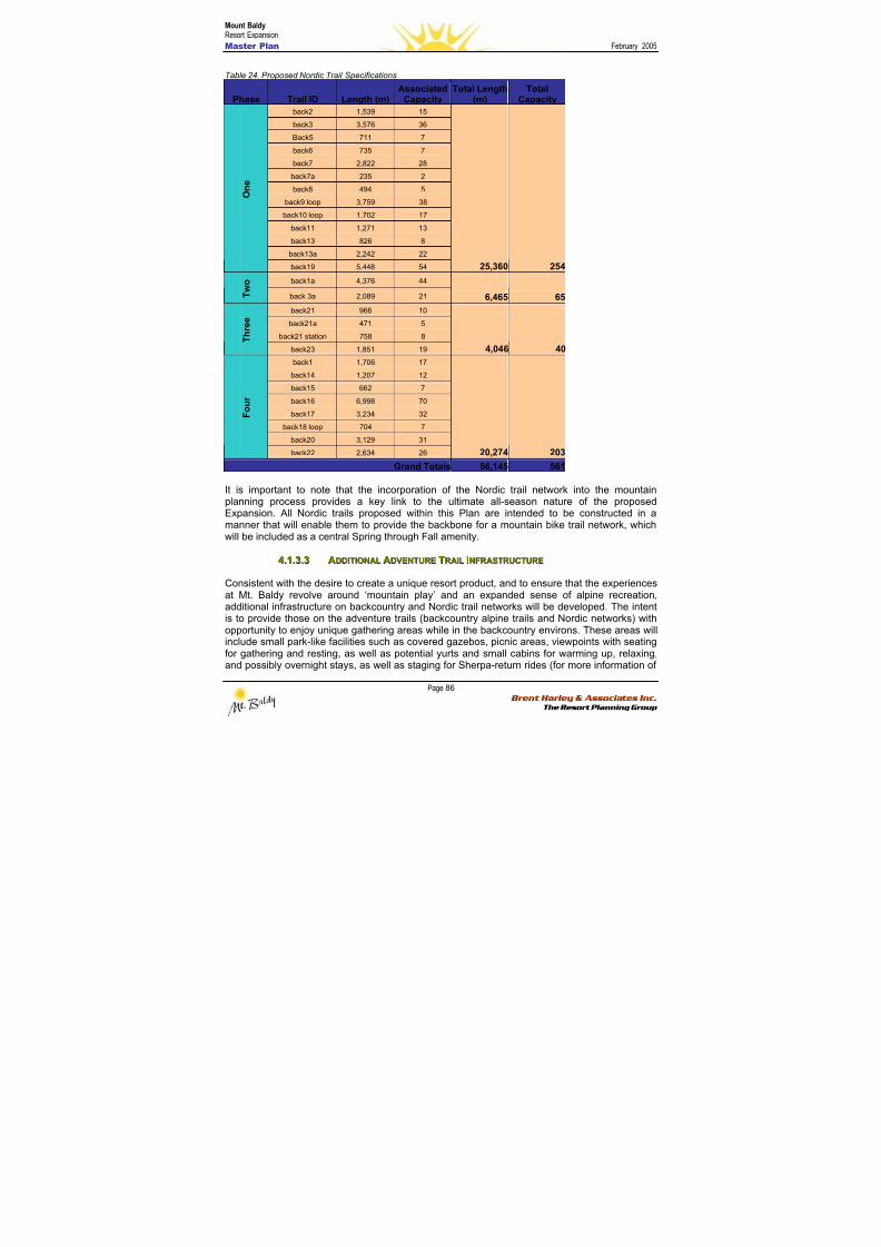
8/12/2019 Mount Baldy
http://slidepdf.com/reader/full/mount-baldy 104/322
Mount BaldyResort Expansion
Master Plan February 2005
Page 86 Brent Harley & Associates Inc.
The Resort Planning Group
Table 24. Proposed Nordic Trail Specifications
Phase Trail ID Length (m)Associated
CapacityTotal Length
(m)Total
Capacity
back2 1,539 15
back3 3,576 36
Back5 711 7back6 735 7
back7 2,822 28
back7a 235 2
back8 494 5
back9 loop 3,759 38
back10 loop 1,702 17
back11 1,271 13
back13 826 8
back13a 2,242 22
O n e
back19 5,448 54 25,360 254
back1a 4,376 44
T w o
back 3a 2,089 21 6,465 65
back21 966 10
back21a 471 5
back21 station 758 8 T h r e e
back23 1,851 19 4,046 40
back1 1,706 17
back14 1,207 12
back15 662 7
back16 6,998 70
back17 3,234 32
back18 loop 704 7
back20 3,129 31
F o u r
back22 2,634 26 20,274 203
Grand Totals 56,145 561
It is important to note that the incorporation of the Nordic trail network into the mountainplanning process provides a key link to the ultimate all-season nature of the proposedExpansion. All Nordic trails proposed within this Plan are intended to be constructed in amanner that will enable them to provide the backbone for a mountain bike trail network, whichwill be included as a central Spring through Fall amenity.
44..11..33..33 AADDDDIITTIIOONNAALL AADDVVEENNTTUURREE TTRRAAIILL IINNFFRRAASSTTRRUUCCTTUURREE
Consistent with the desire to create a unique resort product, and to ensure that the experiencesat Mt. Baldy revolve around ‘mountain play’ and an expanded sense of alpine recreation,additional infrastructure on backcountry and Nordic trail networks will be developed. The intentis to provide those on the adventure trails (backcountry alpine trails and Nordic networks) withopportunity to enjoy unique gathering areas while in the backcountry environs. These areas willinclude small park-like facilities such as covered gazebos, picnic areas, viewpoints with seatingfor gathering and resting, as well as potential yurts and small cabins for warming up, relaxing,and possibly overnight stays, as well as staging for Sherpa-return rides (for more information of
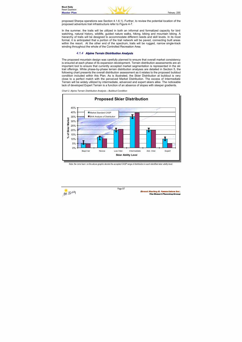
8/12/2019 Mount Baldy
http://slidepdf.com/reader/full/mount-baldy 105/322
Mount BaldyResort Expansion
Master Plan February 2005
Page 87 Brent Harley & Associates Inc.
The Resort Planning Group
Proposed Skier Distribution
0%
5%
10%
15%
20%
25%
30%
35%
40%
45%
Beginner Novice Low Inter. Intermediate Adv. Inter. Expert
Skier Ability Level
% o f S k i e r M a r k e t
Market Standard CASP
BHA Analysis of Distribution
Proposed Skier Distribution
0%
5%
10%
15%
20%
25%
30%
35%
40%
45%
Beginner Novice Low Inter. Intermediate Adv. Inter. Expert
Skier Ability Level
% o f S k i e r M a r k e t
Market Standard CASP
BHA Analysis of Distribution
proposed Sherpa operations see Section 4.1.6.1). Further, to review the potential location of theproposed adventure trail infrastructure refer to Figure 4-7.
In the summer, the trails will be utilized in both an informal and formalized capacity for birdwatching, natural history, wildlife, guided nature walks, hiking, biking and mountain biking. Ahierarchy of trails will be designed to accommodate different needs and skill levels. In its mostformal, it is anticipated that a portion of the trail network will be paved, connecting built areaswithin the resort. At the other end of the spectrum, trails will be rugged, narrow single-trackwinding throughout the whole of the Controlled Recreation Area.
4.1.4 A Al l p pi i nnee T T eer r r r aai i nn DDi i sst t r r i i bbu u t t i i oonn A Annaal l y y ssi i ss
The proposed mountain design was carefully planned to ensure that overall market consistencyis ensured at each phase of its expansion development. Terrain distribution assessments are animportant tool to ensure that currently accepted market segmentation is represented in the skitrail offerings. While phase-by-phase terrain distribution analyses are detailed in Section 5, thefollowing chart presents the overall distribution assessment as it relates to the proposed buildoutcondition included within this Plan. As is illustrated, the Skier Distribution at buildout is veryclose to a perfect match with the perceived Market Distribution. The excess of IntermediateTerrain will be widely utilized by intermediate, advanced and expert skiers alike. The noticeablelack of developed Expert Terrain is a function of an absence of slopes with steeper gradients.
Chart 2. Alpine Terrain Distribution Analysis – Buildout Condition
Note: the ‘error bars’ on the above graphic denote the accepted CASP range of distribution in each identified skier ability level.

8/12/2019 Mount Baldy
http://slidepdf.com/reader/full/mount-baldy 106/322
Mount BaldyResort Expansion
Master Plan February 2005
Page 88 Brent Harley & Associates Inc.
The Resort Planning Group
4.1.5 A Al l p pi i nnee LLi i f f t t I I nnv v eennt t oor r y y aannd d A Annaal l y y ssi i ss
Not only does the skier class distribution need to be balanced with market distribution, but alsothe mountain plan must anticipate skier movement and circulation patterns such thatbottlenecks, pinch points, and congestion zones are avoided. To this end, detailed
disbursement modeling was undertaken to ensure that skiers on slopes, on lifts, in lift lines, andin support facilities are balanced, and that appropriate capacity of uphill infrastructure isdesigned consistent with the project vision and objectives.
Designed in concert with the aforementioned trail infrastructure, the proposed lift system wasplanned to balance and support the alpine trail network. Capacity was also calculated to takeinto account the Nordic skiers lift use that is associated with this Expansion Plan. Consistentwith the goal of providing a unique, low density, powder skiing opportunities, all lifts proposedwithin this plan employ fixed-grip technology. Refer the following tables to review the specificcharacteristics, capacities, and design parameters for each of the proposed lifts.
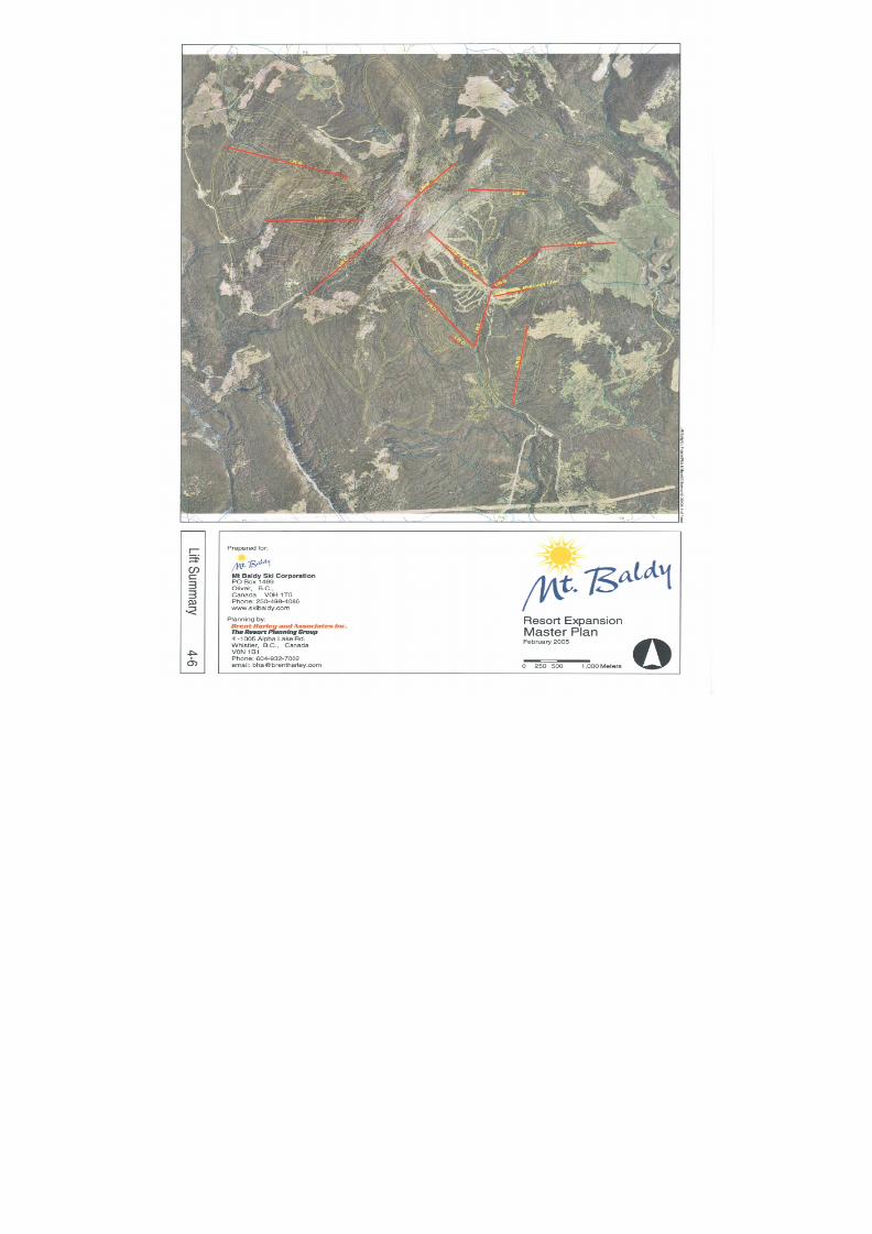
8/12/2019 Mount Baldy
http://slidepdf.com/reader/full/mount-baldy 107/322
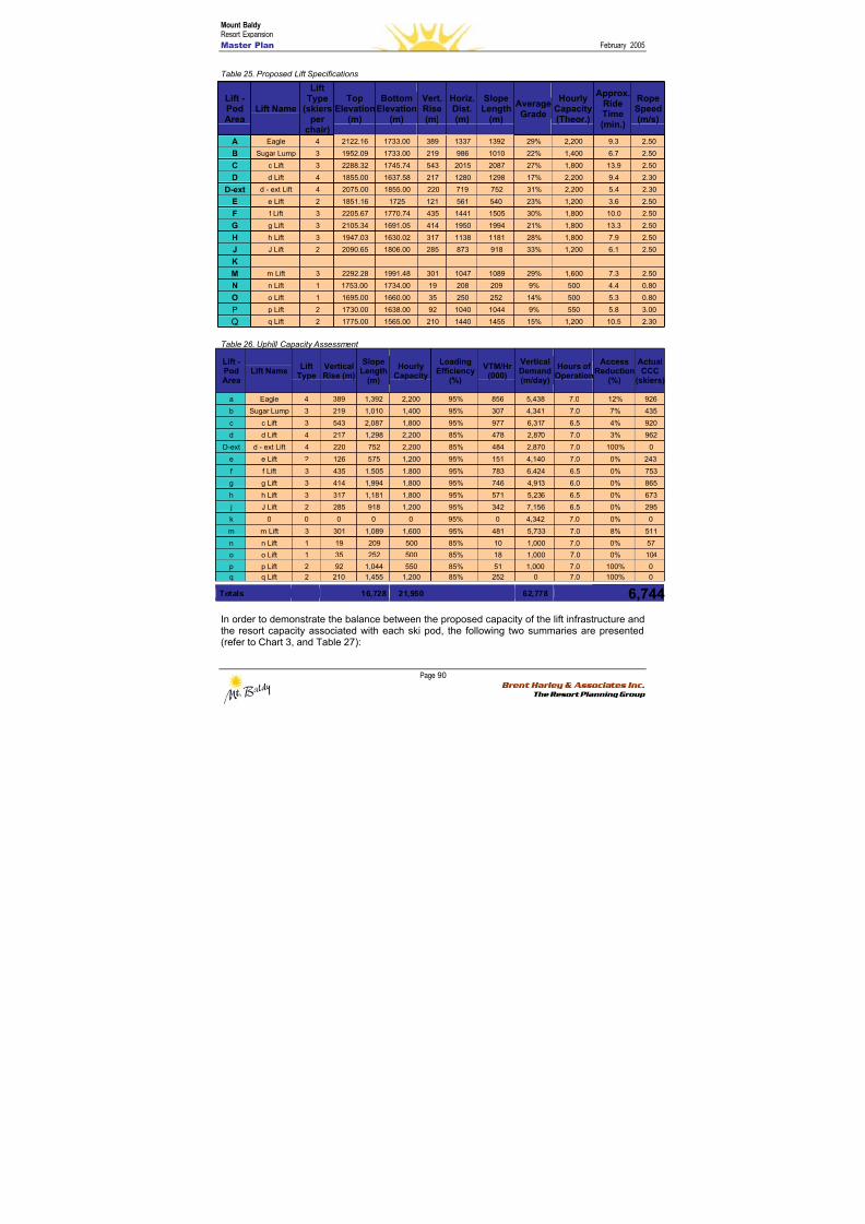
8/12/2019 Mount Baldy
http://slidepdf.com/reader/full/mount-baldy 108/322
Mount BaldyResort Expansion
Master Plan February 2005
Page 90 Brent Harley & Associates Inc.
The Resort Planning Group
Table 25. Proposed Lift Specifications
Table 26. Uphill Capacity Assessment
Lift -PodArea
Lift NameLift
TypeVerticalRise (m)
SlopeLength
(m)
HourlyCapacity
LoadingEfficiency
(%)
VTM/Hr(000)
VerticalDemand(m/day)
Hours ofOperation
AccessReduction
(%)
ActualCCC
(skiers)
a Eagle 4 389 1,392 2,200 95% 856 5,438 7.0 12% 926
b Sugar Lump 3 219 1,010 1,400 95% 307 4,341 7.0 7% 435
c c Lift 3 543 2,087 1,800 95% 977 6,317 6.5 4% 920
d d Lift 4 217 1,298 2,200 85% 478 2,870 7.0 3% 962
D-ext d - ext Lift 4 220 752 2,200 85% 484 2,870 7.0 100% 0
e e Lift 2 126 575 1,200 95% 151 4,140 7.0 0% 243
f f Lift 3 435 1,505 1,800 95% 783 6,424 6.5 0% 753
g g Lift 3 414 1,994 1,800 95% 746 4,913 6.0 0% 865
h h Lift 3 317 1,181 1,800 95% 571 5,236 6.5 0% 673
j J Lift 2 285 918 1,200 95% 342 7,156 6.5 0% 295
k 0 0 0 0 0 95% 0 4,342 7.0 0% 0
m m Lift 3 301 1,089 1,600 95% 481 5,733 7.0 8% 511
n n Lift 1 19 209 500 85% 10 1,000 7.0 0% 57
o o Lift 1 35 252 500 85% 18 1,000 7.0 0% 104
p p Lift 2 92 1,044 550 85% 51 1,000 7.0 100% 0
q q Lift 2 210 1,455 1,200 85% 252 0 7.0 100% 0
Totals 16,728 21,950 62,778 6,744 In order to demonstrate the balance between the proposed capacity of the lift infrastructure andthe resort capacity associated with each ski pod, the following two summaries are presented(refer to Chart 3, and Table 27):
Lift -PodArea
Lift Name
LiftType
(skiersper
chair)
TopElevation
(m)
BottomElevation
(m)
Vert.Rise(m)
Horiz.Dist.(m)
SlopeLength
(m)
AverageGrade
HourlyCapacity(Theor.)
Approx.RideTime(min.)
RopeSpeed(m/s)
A Eagle 4 2122.16 1733.00 389 1337 1392 29% 2,200 9.3 2.50
B Sugar Lump 3 1952.09 1733.00 219 986 1010 22% 1,400 6.7 2.50
C c Lift 3 2288.32 1745.74 543 2015 2087 27% 1,800 13.9 2.50
D d Lift 4 1855.00 1637.58 217 1280 1298 17% 2,200 9.4 2.30
D-ext d - ext Lift 4 2075.00 1855.00 220 719 752 31% 2,200 5.4 2.30
E e Lift 2 1851.16 1725 121 561 540 23% 1,200 3.6 2.50
F f Lift 3 2205.67 1770.74 435 1441 1505 30% 1,800 10.0 2.50
G g Lift 3 2105.34 1691.05 414 1950 1994 21% 1,800 13.3 2.50
H h Lift 3 1947.03 1630.02 317 1138 1181 28% 1,800 7.9 2.50
J J Lift 2 2090.65 1806.00 285 873 918 33% 1,200 6.1 2.50
K
M m Lift 3 2292.28 1991.48 301 1047 1089 29% 1,600 7.3 2.50N n Lift 1 1753.00 1734.00 19 208 209 9% 500 4.4 0.80
O o Lift 1 1695.00 1660.00 35 250 252 14% 500 5.3 0.80
P p Lift 2 1730.00 1638.00 92 1040 1044 9% 550 5.8 3.00
Q q Lift 2 1775.00 1565.00 210 1440 1455 15% 1,200 10.5 2.30
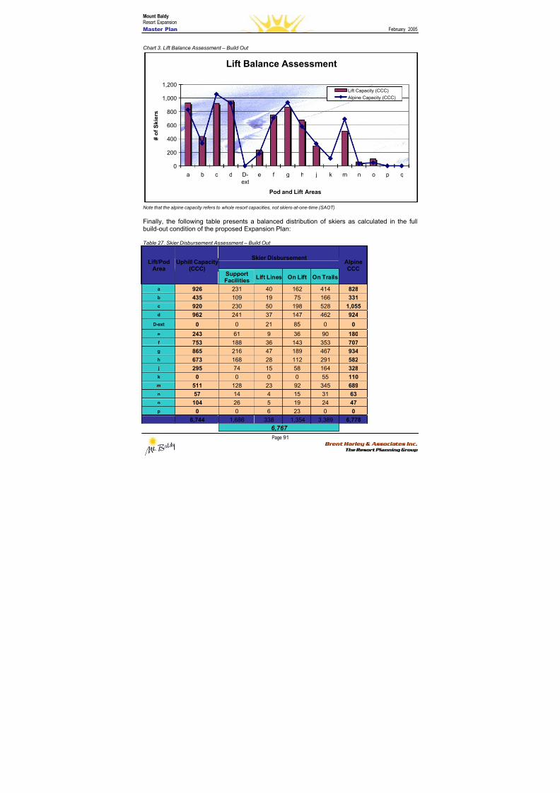
8/12/2019 Mount Baldy
http://slidepdf.com/reader/full/mount-baldy 109/322
Mount BaldyResort Expansion
Master Plan February 2005
Page 91 Brent Harley & Associates Inc.
The Resort Planning Group
Chart 3. Lift Balance Assessment – Build Out
Lift Balance Assessment
0
200
400
600
800
1,000
1,200
a b c d D-
ext
e f g h j k m n o p q
Pod and Lift Areas
# o f S k i e r s
Lift Capacity (CCC)
Alpine Capacity (CCC)
Note that the alpine capacity refers to whole resort capacities, not skiers-at-one-time (SAOT)
Finally, the following table presents a balanced distribution of skiers as calculated in the fullbuild-out condition of the proposed Expansion Plan:
Table 27. Skier Disbursement Assessment – Build Out
Skier DisbursementLift/Pod
Area
Uphill Capacity
(CCC) SupportFacilities
Lift Lines On Lift On Trails
Alpine
CCC
a 926 231 40 162 414 828
b 435 109 19 75 166 331
c 920 230 50 198 528 1,055
d 962 241 37 147 462 924
D-ext 0 0 21 85 0 0
e 243 61 9 36 90 180
f 753 188 36 143 353 707
g 865 216 47 189 467 934
h 673 168 28 112 291 582 j 295 74 15 58 164 328
k 0 0 0 0 55 110
m 511 128 23 92 345 689
n 57 14 4 15 31 63
o 104 26 5 19 24 47
p 0 0 6 23 0 0
6,744 1,686 338 1,354 3,389 6,778
6,767
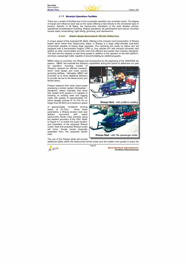
8/12/2019 Mount Baldy
http://slidepdf.com/reader/full/mount-baldy 110/322
Mount BaldyResort Expansion
Master Plan February 2005
Page 92 Brent Harley & Associates Inc.
The Resort Planning Group
4.1.6 M M oou u nnt t aai i nn O O p peer r aat t i i oonnss F F aac c i i l l i i t t i i eess
There are a variety of facilities key to the successful operation any mountain resort. The degreeof impact and influence each has on the resort offering is tied directly to the envisioned type ofproduct. Specific to Mt Baldy, the backcountry orientation of the area dictates primary
operational considerations including: Sherpa operations; ski patrol/search and rescue; mountainaccess roads; snowmaking; night skiing; grooming; and maintenance.
44..11..66..11 SSHHEERRPPAA--BBAASSEEDD BBAACCKKCCOOUUNNTTRR Y Y RREETTUURRNN OOPPEERRAATTIIOONNSS
A unique aspect of the proposed Mt. Baldy offering is the inclusion and incorporation of Sherpabased return travel from backcountry areas. A Sherpa is a large utility-oriented dual-tracksnowmobile capable of towing large payloads. The machines are made by Alpina and areequipped with a low-emission engine (1360 cc, four cylinder EFI with exhaust converter) andrelative to other snowmobiles are both more fuel efficient and quieter than industry standards.The sled has the capacity to seat three guests in addition to the operator on the sled platform,and tows a passenger trailer capable of accommodating six additional guests.
MBSC plans to purchase one Sherpa and accessories by the beginning of the 2005/2006 skiseason. MBSC will evaluate the Sherpa’s capabilities during this period to determine our planfor operation, including number ofSherpa’s required for efficient transport,return route design and cross countrygrooming abilities. Ultimately, MBSC willpurchase up to three additional Sherpa’sto provide service to the Backcountry andNordic skiers.
Product research from other resort areasemploying a similar system (Schweitzer -Sandpoint, Idaho) indicates that whenfully loaded (6-9) guests it is capable oftraveling on existing trails and loggingroads with grades of approximately 4%(short straight inclines of 10-12% for nolonger than 60-80m) at a maximum speed
of approximately 15-20km/h (turningradius of 10-12m). Given theseparameters, a Sherpa access route wasdefined concurrent with selectbackcountry Nordic trails primarily along
the western boundary of the CRA. Referto Figure 4-7 to review the exact locationand orientation of the proposed Sherparoutes. Note that proposed Sherpa routeswill mirror, though remain physicallyseparated from, the proposed Nordictrails.
The use of the Sherpa sleds will provideadditional safety within the backcountry terrain areas and will enable more guests to enjoy the
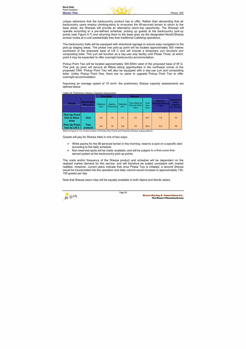
8/12/2019 Mount Baldy
http://slidepdf.com/reader/full/mount-baldy 111/322
Mount BaldyResort Expansion
Master Plan February 2005
Page 93 Brent Harley & Associates Inc.
The Resort Planning Group
unique adventure that the backcountry product has to offer. Rather than demanding that allbackcountry users employ climbing-skins to re-access the lift-serviced terrain to return to thebase areas, the Sherpas will provide an alternative return-trip opportunity. The Sherpas willoperate according to a pre-defined schedule, picking up guests at the backcountry pick-uppoints (see Figure 4-7) and returning them to the base area via the designated Nordic/Sherpaaccess routes at a cost substantially less than traditional Catskiing operations.
The backcountry trails will be equipped with directional signage to ensure easy navigation to thepick-up staging areas. The phase one pick-up point will be located approximately 500 metressouthwest of the proposed base of Lift C and will include a temporary yurt structure andcomposting toilet. This yurt will function as a day-use only facility until Phase Three, at whichpoint it may be expanded to offer overnight backcountry accommodation.
Pickup Point Two will be located approximately 300-500m west of the proposed base of lift G.This pick up point will service all liftless skiing opportunities in the northwest corner of theproposed CRA. Pickup Point Two will also be equipped with a day-use yurt and compostingtoilet. Unlike Pickup Point One, there are no plans to upgrade Pickup Point Two to offerovernight accommodation.
Assuming an average speed of 15 km/h, the preliminary Sherpa capacity assessments aredefined below:
Table 28. Preliminary Sherpa Capacity Assessment
One Way Return
RouteAssociated
Phase(s) Distance(km)
Approx.Time (min)
Distance(km)
Time Spent atPick Up Point
(min)
Totaltime(min)
PotentialTrips/Day/Sherpa
(7 hrs)
MaximumDaily
Capacityper Sherpa
Pick Up Point
One to BaseArea One 4.8 19 9.7 15 53.7 7.8 70
Pick Up PointTwo to Lift C
Twoonward
4.4 18 8.8 15 50.0 8.4 76
Refer to Figure 4-7 to review location of Primary Pick Points and Proposed Sherpa routing patterns
Guests will pay for Sherpa rides in one of two ways:
• While paying for the lift-serviced terrain in the morning, reserve a spot on a specific sledaccording to the daily schedule.
• Non-reserved spots will be made available, and will be subject to a first-come first-served system at the backcountry pick-up points.
The costs and/or frequency of the Sherpa product and schedule will be dependant on therealized market demand for this service, and will therefore be scaled consistent with marketrealities. However, current plans indicate that once Phase Two is initiated, a second Sherpawould be incorporated into the operation and daily volume would increase to approximately 130-150 guests per day.
Note that Sherpa return trips will be equally available to both Alpine and Nordic skiers.

8/12/2019 Mount Baldy
http://slidepdf.com/reader/full/mount-baldy 112/322
Mount BaldyResort Expansion
Master Plan February 2005
Page 94 Brent Harley & Associates Inc.
The Resort Planning Group
Consistent with the goals of providing a unique, family-oriented atmosphere of ‘mountain play’,the Sherpa sleds allow new backcountry enthusiasts the opportunity to explore backcountryterrain in a controlled, safe atmosphere with a guaranteed access back to the comforts of thebase area at the end of the day. Moreover, the diversity of product that the backcountry-Sherpaoperations create will make it easier for the whole family to vacation at Mt. Baldy – somemembers of the family or group can ski traditional lift-serviced terrain at the same time and atthe same resort, as others in the group take on the adventure-oriented terrain of thebackcountry.
The Sherpa operations also ease the transition into new ski areas and afford flexibility in thephasing program over time. Opening an area to Sherpa operations is a low-cost (relative to lift-servicing) endeavour and it allows for preliminary run and glade development to precede higherdensity lift-serviced use in later phases.
Finally, the flexibility inherent in the Sherpa design is well suited to afford additional usagepatterns and/or roles within the mountain operations plan, some of these uses may include:
• Nordic trail grooming responsibilities• Transport of Nordic and snowshoeing guests to remote staging areas and/or
backcountry events• Transport of employees around the proposed CRA• Evacuation of injured skiers and/or riders• Flexibility to potentially offer an early or late season uphill conveyance product (similar to
typical snowcat operation)
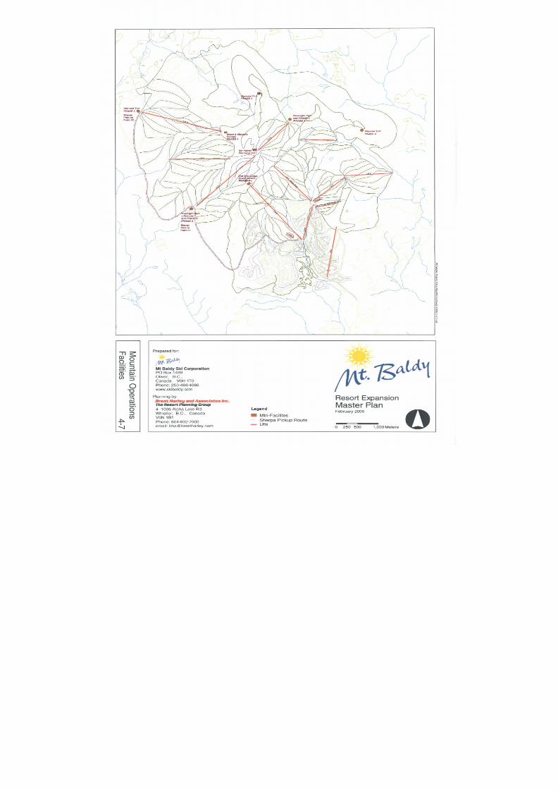
8/12/2019 Mount Baldy
http://slidepdf.com/reader/full/mount-baldy 113/322
8/12/2019 Mount Baldy
http://slidepdf.com/reader/full/mount-baldy 114/322
Mount BaldyResort Expansion
Master Plan February 2005
Page 96 Brent Harley & Associates Inc.
The Resort Planning Group
44..11..66..22 SSKKII PPAATTRROOLL FFAACCIILLIITTIIEESS
The phased development of ski patrol facilities is a key component of a well planned, andeffectively managed mountain operation – this is especially true when the plan includes in-bounds backcountry products. Design considerations include the need to be able to provide on-snow, toboggan access to medical facilities as well as vehicular and ambulance access toinjured or sick guests. The current development progression of patrol facilities is defined asfollows:
Phase 1 – Patrol Hut to move to existing day lodge and rebuild current patrol hut at top of theEagle Chair. After operations open in the north bowl (Pod M) MBSC would build a hut at thesummit saddle, thereby effectively servicing both the M Pod and the backcountry terrain ofsouthwest bowl (Pod C). Hire a certified level two patroller with blasting license and installpermanent fencing and signage at summit to direct skiers around saddle and into thefrontcountry terrain (A Pod) All access into backcountry areas (C and F Pods) will be via agated entry with signage explaining terrain, return options and safety regulations. Whenconditions warrant, all backcountry skiing in these Pods will be closed.
Phase 2 – A new main patrol hut will be incorporated into one of the new lodges being built inthe upper village. This facility will function as the main patrol/first aid station. An additionalremote patrol hut will be built at the bottom of the C Pod near the yurt pickup point and asecondary Patrol room will be incorporated into the emerging built form in the Village Base.
Phase 3 – After Pod H opens on the backside of Sugar Lump (Pod B), MBSC will add a remotepatrol hut at the top of Lift B.
Phase 4 – Once lift infrastructure is incorporated into the F and G Pods, an additional remotePatrol Hut will be added in the G Pod.
Backcountry Safety
All inbounds backcountry terrain will be patrolled and avalanche controlled. MBSC will providefree mandatory avalanche training to all critical staff and will subsidize training for all otheremployees. Recreational Avalanche Classes will be offered to the public for a fee, and MBSCwill post daily avalanche forecasts on the Internet as well as in a central location at the baseareas. Additionally, MBSC will monitor predefined radio channels and provide radios for anominal rental fee to backcountry users. GPS coordinates will be placed on maps and GPSunits will be available at a nominal fee.
44..11..66..33 MMOOUUNNTTAAIINN AACCCCEESSSS RROOAADDSS
Building on the existing infrastructure of mountain access roads, an additional mountain accessroad infrastructure has been planned. Mountain access roads provide service access, safety,
access to future development areas/trails, and are a critical component of a well functioning skiarea. Mountain road development will also provide additional summer infrastructure for summer-season products such as bird-watching, mountain-biking and hiking.

8/12/2019 Mount Baldy
http://slidepdf.com/reader/full/mount-baldy 115/322
Mount BaldyResort Expansion
Master Plan February 2005
Page 97 Brent Harley & Associates Inc.
The Resort Planning Group
44..11..66..44 SSNNOOWWMMAAKKIINNGG
Proposed snowmaking is limited to a variety of select runs. The objective will be to ensure thatMt Baldy is able to open for limited early season skiing within the B, E and N Pods. Likewise,snowmaking capabilities will be on trails to reinforce snowpack on high-use circulation trailsdown to the Upper Base, the Village and to the real estate at the base of Lift O. Existingreservoirs will be expanded and used to provide the requisite water resources, and appropriatesnow-gun infrastructure will be incorporated into the mountain development plan during thebeginning of phase two and will be developed concurrently with lighting standards. The specificdetails for the proposed snowmaking will be confirmed at the time of development, and willreflect leading technologies and products available at that time.
Refer to Figure 4-8 to review the location and orientation of proposed snowmakinginfrastructure.
44..11..66..55 LLIIGGHHTTIINNGG
Lighting for night skiing will be limited to terrain in the B and E Pods. In addition, the return orconnector trail between the Upper Base and the Village will be lighted for night-time circulation.Finally, in the later phases of the resorts’ development, a series of Nordic trail loops staged fromthe Village may also have lighting.
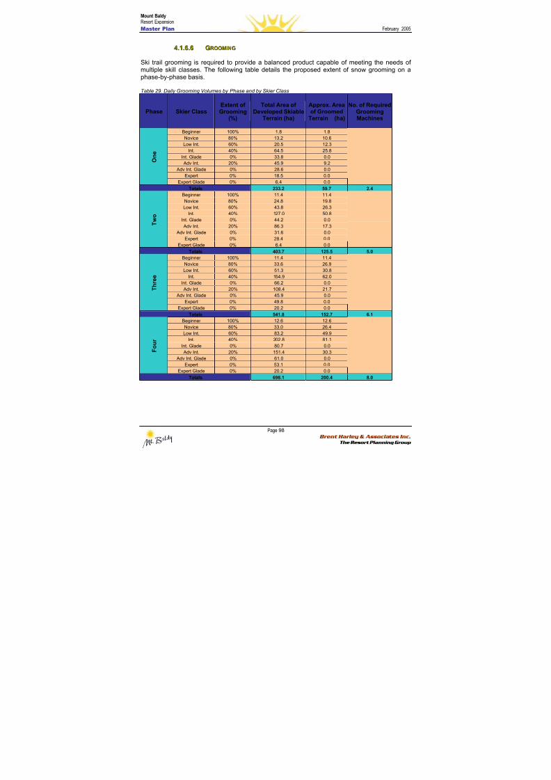
8/12/2019 Mount Baldy
http://slidepdf.com/reader/full/mount-baldy 116/322
Mount BaldyResort Expansion
Master Plan February 2005
Page 98 Brent Harley & Associates Inc.
The Resort Planning Group
44..11..66..66 GGRROOOOMMIINNGG
Ski trail grooming is required to provide a balanced product capable of meeting the needs ofmultiple skill classes. The following table details the proposed extent of snow grooming on aphase-by-phase basis.
Table 29. Daily Grooming Volumes by Phase and by Skier Class
Phase Skier ClassExtent ofGrooming
(%)
Total Area ofDeveloped Skiable
Terrain (ha)
Approx. Areaof Groomed
Terrain (ha)
No. of RequiredGroomingMachines
Beginner 100% 1.8 1.8
Novice 80% 13.2 10.6
Low Int. 60% 20.5 12.3
Int. 40% 64.5 25.8
Int. Glade 0% 33.8 0.0
Adv Int. 20% 45.9 9.2
Adv Int. Glade 0% 28.6 0.0
Expert 0% 18.5 0.0
O n e
Expert Glade 0% 6.4 0.0
Totals 233.2 59.7 2.4
Beginner 100% 11.4 11.4
Novice 80% 24.8 19.8
Low Int. 60% 43.8 26.3
Int. 40% 127.0 50.8
Int. Glade 0% 44.2 0.0
Adv Int. 20% 86.3 17.3
Adv Int. Glade 0% 31.6 0.0
Expert 0% 28.4 0.0
T w o
Expert Glade 0% 6.4 0.0
Totals 403.7 125.5 5.0
Beginner 100% 11.4 11.4
Novice 80% 33.6 26.9Low Int. 60% 51.3 30.8
Int. 40% 154.9 62.0
Int. Glade 0% 66.2 0.0
Adv Int. 20% 108.4 21.7
Adv Int. Glade 0% 45.9 0.0
Expert 0% 49.8 0.0
T h r e e
Expert Glade 0% 20.2 0.0
Totals 541.8 152.7 6.1
Beginner 100% 12.6 12.6
Novice 80% 33.0 26.4
Low Int. 60% 83.2 49.9
Int. 40% 202.8 81.1
Int. Glade 0% 80.7 0.0
Adv Int. 20% 151.4 30.3 Adv Int. Glade 0% 61.0 0.0
Expert 0% 53.1 0.0
F o u r
Expert Glade 0% 20.2 0.0
Totals 698.1 200.4 8.0
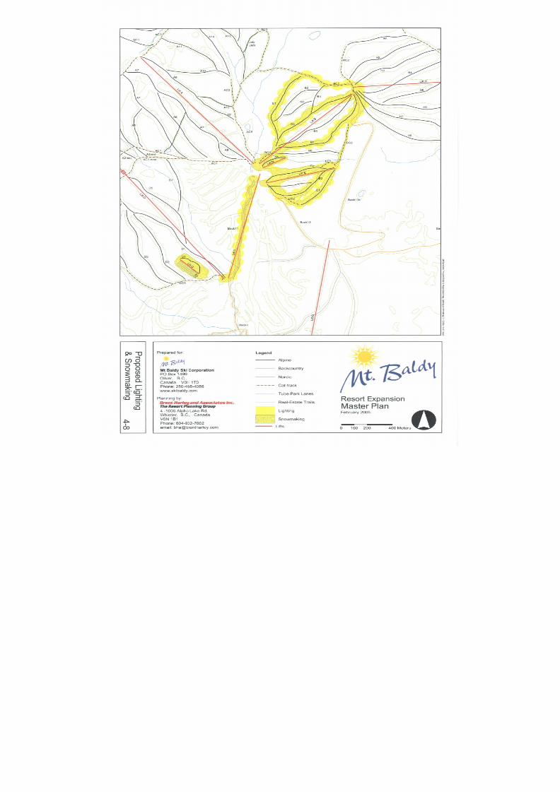
8/12/2019 Mount Baldy
http://slidepdf.com/reader/full/mount-baldy 117/322
8/12/2019 Mount Baldy
http://slidepdf.com/reader/full/mount-baldy 118/322
8/12/2019 Mount Baldy
http://slidepdf.com/reader/full/mount-baldy 119/322
Mount BaldyResort Expansion
Master Plan February 2005
Page 101 Brent Harley & Associates Inc.
The Resort Planning Group
44..22 BBAASSEE AARREEAA DDEEVVEELLOOPPMMEENNTT
The Master Plan for the proposed base area development at Mt. Baldy has been designed tocomplement the mountain’s natural attributes and proposed facilities (See Figures 4-9 through4-13). The natural setting and the opportunity to engage in mountain play, retreat and recreation
is the primary reason guests, visitors and residents are attracted to the resort. Acknowledgingthis, the following section describes the various elements contained within the base areas; theirrelationships with the mountain facilities; and the means by which the base area facilities aredesigned to meet the needs and expectations of the MT. Baldy resort community.
4.2.1 BBaassee A Ar r eeaa DDeev v eel l oo p pmmeennt t G G ooaal l ss
The following are the defined primary base area development goals. Each is consistent with theoverall vision and each was employed to guide and inform the proposed design.
• Establish facilities that are consistent with, and complement the Mt Baldy vision as a specialplace where the outdoor environment is celebrated, where people are valued, and the
timeless spirit of skiing and mountain play still thrive.
• Ensure that the base area development takes on a ‘retreat’ and ‘escape’ ambiance
• Establish a pedestrian oriented and self propelled character to all built development bycreating a compact, Smart Growth oriented development footprint that is directly tied to theresort's mountain and backcountry orientation and associated staging facilities.
• Incorporate direct linkages to and from the base areas and resort residential developmentareas by ensuring the establishment of ski to / ski from trail development as well as thecreation of a highly integrated trail network.
• Establish all of the base area facilities and residential development in balance with thecapacities of the resort's attractions – recognizing that there are absolute limits to growth.
• Ensure that all development is completed in a highly proactive environmentally sensitivefashion
• Incorporate of a variety of resort residential forms and tenure
• Incorporate affordable resident and employee housing
4.2.2 DDeev v eel l oo p pmmeennt t A Ar r eeaass
At buildout, Mt. Baldy will effectively have two base areas – the Upper Base and the Village.These two areas will be linked by ski trails, a multi-season trail network and a ‘people-mover’ lift.Infilling the lands between the bases will be a variety of ski to/ski from residentialaccommodations.
Upper BaseThe Upper Base has its focus defined by the main ski trails serviced by the Eagle Chair and theSugar Lump lifts and trails. It will include a core of buildings housing visitor services, intimaterestaurants and lounges, and a small number of accommodation units all oriented to access,view and celebrate being at Mt. Baldy. The existing day lodge will be converted to include
8/12/2019 Mount Baldy
http://slidepdf.com/reader/full/mount-baldy 120/322
Mount BaldyResort Expansion
Master Plan February 2005
Page 102 Brent Harley & Associates Inc.
The Resort Planning Group
administration and employee facilities. The upper terminal of the people mover is located inclose proximity to the Upper Base core. A low gradient trail (10% slope) will lead guests aspedestrians, Nordic skiers, bikers, skiers and snowboarders from the Upper Base back down tothe Village.
The Upper Base will be primarily day-use oriented. Parking lots for these visitors have beenplaced to be within acceptable skier walking distance (Refer to Figure 4-11).
The VillageThe Mt. Baldy Village is located about one kilometre south of the Upper Base at an elevationapproximately 100 vertical metres lower. The focal point is located in close proximity to the baseof the alpine skiing as serviced by Lift D, and directly connected to the Nordic skiing/mountainbiking trail system. In addition, the first and last holes of the eighteen-hole golf course begin andend, at the Village. Additionally, the tube park and beginner teaching area (serviced by a magiccarpet lift) is located immediately uphill from the Village core. The people mover originates atthe core area and is in direct association with the return trail coming down from the Upper Base.
The core of the Village will include a variety of buildings, all designed to meet the needs ofguests visiting Mt. Baldy. Integral to the core will be the mountain resort spa, of which thetherapeutic, massage and specialized water park facilities will prove to be a prefect complementand attraction to the resort (Refer to Figure 4-12).
Resort Residential Areas A series of resort residential areas incorporating a variety of public and private accommodationhave been designed to infill between, and around, the Upper Base and Village areas. Thesedevelopments are located to keep the development footprint compact, pedestrian-oriented andski to/ski from capable. All of the development has been carefully placed to respect streams andassociated riparian zones. The desired effect is to incorporate the buildings, to the greatestdegree possible, into the landscape. The design guidelines will require development to be‘green-building’ oriented. The vast majority of resort residential is alpine ski to/ski from capable.Further, all development will be linked by a resort trail system designed to enable all guestsdirect self-propelled access to the adjacent developments, the two base areas, and thebackcountry (Refer to Figure 4-10).
4.2.3 BBu u i i l l t t S S p paac c ee R R eeq q u u i i r r eemmeennt t ss
Built space requirements are driven by the described carrying capacity of the resort’s facilities. At buildout, the Upper Base and the Village at Mt. Baldy must have the ability to provide for theneeds of approximately 7,775 guests and residents. The types of built space necessary toprovide for the needs and expectations of the guests range form restaurants, lounges,commercial and retail outlets, rental and repair shops, guest services, ski school, patrol/first aid,day care, lockers as well as resort administration and employee facilities. In total, approximately9,900 square metres (106,500 sq ft) of skier-related built space will be in place at buildout.
Additional specialized, destination oriented space for restaurants, retail outlets,convention/seminars, retreat facilities, spas and recreation facilities all have to be taken intoaccount. With the establishment of the proposed mix of private and public accommodation,approximately 4,600 sq metres (49,500 sq ft) of additional built space will be established. As ageneral breakdown, about 1,600 sq m would be for restaurants; 1,150 sq m for entertainment;1,375 sq m for retail, and; 450 sq m for convention/seminar space.
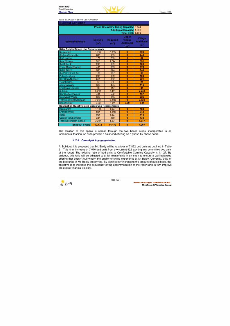
8/12/2019 Mount Baldy
http://slidepdf.com/reader/full/mount-baldy 121/322
Mount BaldyResort Expansion
Master Plan February 2005
Page 103 Brent Harley & Associates Inc.
The Resort Planning Group
Table 30. Buildout Space Use Allocation
The location of this space is spread through the two bases areas, incorporated in anincremental fashion, so as to provide a balanced offering on a phase-by-phase basis.
4.2.4 O O v v eer r nni i g g hht t A Ac c c c oommmmood d aat t i i oonn
At Buildout, it is proposed that Mt. Baldy will have a total of 7,892 bed units as outlined in Table31. This is an increase of 7,070 bed units from the current 822 existing and committed bed unitsat the resort. The existing ratio of bed units to Comfortable Carrying Capacity is 1:1.27. Bybuildout, this ratio will be adjusted to a 1:1 relationship in an effort to ensure a well-balancedoffering that doesn't overwhelm the quality of skiing experience at Mt Baldy. Currently, 95% ofthe bed units at Mt. Baldy are private. By significantly increasing the amount of public beds, theobjective is to increase the occupancy of the accommodation at the resort and in turn improvethe overall financial viability.
6,7441,0317,775
Service/FunctionExisting
(m2)
Required
(m2)
UpperVillage
Additional
m2
Village
Additional
(m2)
Restaurant 1,712 2,333 0 620Kitchen/Scramble 685 933 0 248Bar/Lounge 171 233 0 62Rest Rooms 913 1,244 0 331Ski School 285 389 0 103Equip Rental/Repair 491 669 0 178Retail Sales 399 544 0 145
Ski Patrol/First Aid 188 257 0 68Public Lockers 285 389 0 103Day Care/Nursery 611 832 0 221Ticket Sales 57 78 0 21 Administration 320 435 0 116Employee Lockers 86 117 0 31Subtotal 6,204 8,451 0 2,248Storage/Mechanical 434 592 0 157Circ./Wall/Waste 620 845 0 225Total Ski Related Space 7,258 9,888 0 2,630Space/Skier 0.93 1.27 0.00 0.34
Restaurant 1,125 1,607 0 482Entertainment 804 1,148 0 344Retail 964 1,377 0 413Convention/Seminar 321 459 0 138Total Destination Space 3,214 4,591 0 1,377
Buildout Totals 10,472 14,479 0 4,007
Total CCC:
Skier Related Space Use Requirements
Buildout Condition
Phase One Alpine Skiing Capacity:Additional Capacity:
Destination Guest Related Space Use Requirements
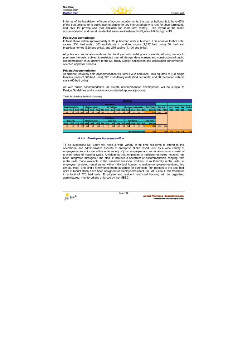
8/12/2019 Mount Baldy
http://slidepdf.com/reader/full/mount-baldy 122/322
Mount BaldyResort Expansion
Master Plan February 2005
Page 104 Brent Harley & Associates Inc.
The Resort Planning Group
In terms of the breakdown of types of accommodation units, the goal at buildout is to have 45%of the bed units cater to public use (available for any interested party to rent for short term use),and 55% for private use (not available for short term rental). The layout of the resortaccommodation and resort residential areas are illustrated in Figures 4-9 through 4-13.
Public AccommodationIn total, there will be approximately 3,590 public bed units at buildout. This equates to 379 hotelrooms (758 bed units), 303 multi-family / condotel rooms (1,212 bed units), 52 bed andbreakfast homes (520 bed units), and 275 cabins (1,100 bed units).
All public accommodation units will be developed with rental pool covenants, allowing owners topurchase the units, subject to restricted use. All design, development and construction of publicaccommodation must adhere to the Mt. Baldy Design Guidelines and associated conformance-oriented approval process.
Private Accommodation At buildout, privately held accommodation will total 4,302 bed units. This equates to 428 singlefamilies (units (2,568 bed units), 226 multi-family units (904 bed units) and 30 recreation vehiclestalls (60 bed units).
As with public accommodation, all private accommodation development will be subject toDesign Guidelines and a conformance-oriented approval process.
Table 31. Buildout Bed Unit Summary
4.2.5 E E mm p pl l ooy y eeee A Ac c c c oommmmood d aat t i i oonn
To be successful Mt. Baldy will need a wide variety of full-time residents to attend to theoperational and administrative aspects of enterprise at the resort. Just as a wide variety ofemployee types coincide with a wide variety of jobs, employee accommodation must consist ofa wide range of housing types. Anticipating this, employee or resident-restricted housing has
been integrated throughout the plan. It includes a spectrum of accommodation, ranging fromrental units made available to the transient seasonal workers; to multi-family rental units; toemployee restricted rental suites within individual homes; to resident/employee-restricted, feesimple, multi- and single-family units made available for purchase. Ten percent of the total bedunits at Mount Baldy have been assigned for employee/resident use. At Buildout, this translatesin a total of 770 bed units. Employee and resident restricted housing will be organizedadministered, monitored and enforced by the MBSC.
Single Family Units Multi-family Units RV Park Units Employee Housing Units Total Private Uphill Alpine Total Tot/Built
Exist Com. Total BUs Exist Com. Total BUs Exist Com. Total BUs Exist Com. Total BUs Bed Units Ratio Added CCC CCC CCC Ratio
358 70 428 2568 176 50 226 904 30 0 30 60 285 100 385 770 4302 55% 820
B&B Units Multi-family Units Cabin Units Hotel Rooms Total Public
Exist Com. Total BUs Exist Com. Total BUs Exist Com. Total BUs Exist Com. Total BUs Bed Units
37 15 52 520 198 105 303 1212 175 100 275 1100 244 135 379 758 3590 45% 1240
7892 2060 6744 6778 7776 1.01
Private Beds
Buildout
Public Beds
Total Buildout Bed Units
Bed Units
8/12/2019 Mount Baldy
http://slidepdf.com/reader/full/mount-baldy 123/322
Mount BaldyResort Expansion
Master Plan February 2005
Page 105 Brent Harley & Associates Inc.
The Resort Planning Group
4.2.6 G G ool l f f F F aac c i i l l i i t t i i eess
An opportunity to develop an eighteen-hole golf course has been incorporated in the MasterPlan. The illustrated routing plan has the golf course staging from the Village core, windingthrough undulating terrain and ultimately returning to the Village. The intent is to create a high
calibre resort course that will offer visitors and residents at Mount Baldy a satisfying andrewarding golf experience. The mountain setting and cooler summer temperatures will prove tobe a complement to the high temperature ‘arid’ golf found in Oliver and Osoyoos. Collectively,the addition of the Mt. Baldy course will add a new dimension to the golf destination market ofthe Southern Okanagan. Rounding out the golf product, a driving range and teaching academywill be developed in the area of the tubing and beginner skiing slopes in front of the Village,thereby giving those winter oriented facilities a summer use.
4.2.7 M M oou u nnt t aai i nn S S p paa / / P P aar r k k F F aac c i i l l i i t t i i eess
A mountain retreat/spa will be developed as a water-based amenity to Mt. Baldy. This willinclude a water park providing indoor/outdoor all season swimming as well as specialized skills
based water activities such as surfing, white water kayaking and boogie boarding. Directly tiedto, and associated with this will be spa facilities for physiotherapy, massage, as well as awellness centre and sports medicine clinic.
4.2.8 P P aar r k k i i nng g
Based on the Buildout resort capacity, parking must be available for approximately 7,775 guestsand residents. Assuming that 85% of this capacity will arrive by car, and based on an average of3 occupants per car, the parking areas must be capable of accommodating about 2,200 cars.The remaining 15% of guests would be expected to arrive by bus. Assuming 40 visitors per bus,approximately 29 buses would have to be accommodated on a busy day. The actual parkingrequirement will be a function of the establishment of an expanded shuttle system from Oliver
and Osoyoos.
Day use parking has been planned and delineated to accommodate 670 cars in the Upper Baseparking lots. Likewise, parking lot capacity in the Village totals 720 cars.
All parking requirements associated with the Village core commercial development and publicaccommodation are provided for in underground parking below the core for approximately 400cars. The remaining car parking requirements are attached to the site of each of the residentialdevelopments.
The resort roads have been designed to be wide enough for two-way through traffic. This willminimize the cut and fill requirements to build the roads; reduce the paved road surface area,and; reduce the amount of snow clearing and snow storage. This in turn, will minimize theenvironmental impact of the roads developed at Mount Baldy. As such, there will be no on streetparking permitted.
8/12/2019 Mount Baldy
http://slidepdf.com/reader/full/mount-baldy 124/322
Mount BaldyResort Expansion
Master Plan February 2005
Page 106 Brent Harley & Associates Inc.
The Resort Planning Group
4.2.9 DDeessi i g g nn G G u u i i d d eel l i i nneess
Design Guidelines will be developed to ensure consistency of character, construction qualityand built form performance (e.g. Energy efficiency, product procurement and other greenbuilding standards) throughout the resort. These will be applied to all buildings in the base
areas, including on-mountain facilities and the residential and commercial buildings throughoutthe resort. The guidelines will be created and put in place immediately so as to ensure that thetone, ambiance and character of the first phases resort development are consistent with theenvisioned result at buildout. Acknowledging that the Design Guidelines are critical to both theshort and long term success of the resort, the Mt. Baldy Ski Corporation will ensure that theappropriate covenants are placed on all development at the resort, regardless of who theultimate developer may be. MBSC will maintain control of the administration, implementationand enforcement of the Design Guidelines.
44..33 ZZOONNIINNGG
The development lands at Mount Baldy will be zoned based on submissions and dialogue with
the Regional District of Kootenay Boundary. To create the desired character, ambiance andquality, it is anticipated that a Comprehensive Development Zone will be created specifically forMt. Baldy.
44..44 SSUUSSTTAAIINNAABBIILLIITT Y Y CCHHAARRAACCTTEERRIISSTTIICCSS
As discussed in the Project Vision, it is the intent of the Mount Baldy Ski Corporation to create aresort community and ski area product that is premised on the principles of stewardship andresponsibility. These principles have informed the planning and design processes through theadoption of best management practices that, in many cases, exceed the relevant legislation andseek to ensure that natural values are protected, that associated ecological integrity isrespected and that the operations of the ski area product continually strive to improve their
environmental performance through informed procurement and leading-edge technologies.
Examples of on-the-ground improvements related to this commitment are included below:
• The incorporation of design guidelines that include green building objectives, criteria, andminimum standards,
• The incorporation of MBSC company-wide sustainable procurement strategies,• The pre-emptive incorporation of a bear-management strategy,• The incorporation of a comprehensive recycling centre to be established at the maintenance
area,• The use of riparian habitat protection best practices, including a full 30m standard setback
on all watercourses,
• Restoration of damaged riparian habitat along McKinney Creek,• Incorporation of a trail development plan to avoid the removal of large and old growth trees,
and enabling appropriate on-the-ground trail alignment adjustments,• Incorporation of soil erosion best practices to minimize the loss of valuable topsoils and
associated vegetation,• Planning and designs that minimize requisite grading,• The inclusion of low-impact backcountry-only access areas within the CRA,• The choice to employ low-emission, fuel efficient Sherpa snowmobile technologies in
backcountry areas,• Application for Audubon Sanctuary Certification for the proposed golf course development,

8/12/2019 Mount Baldy
http://slidepdf.com/reader/full/mount-baldy 125/322
Mount BaldyResort Expansion
Master Plan February 2005
Page 107 Brent Harley & Associates Inc.
The Resort Planning Group
• Alternative power systems (solar, geothermal) will be explored through a renewable energycapacity study and implemented when feasible,
• The design of compact, walkable neighbourhoods that encourage car-free travel within theresort community,
• As a commitment to reducing air pollution and greenhouse gas emissions of convenient
Shuttle system from both Oliver and Osooyos,• A commitment to a financial strategy based on managing capital investment that utilized
fixed-grip ski lift technologies to ensure financial sustainability over the long-term,• The use and purchase of local and regional goods and services wherever possible.
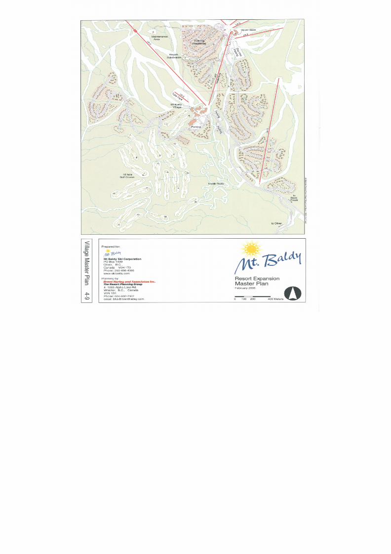
8/12/2019 Mount Baldy
http://slidepdf.com/reader/full/mount-baldy 126/322
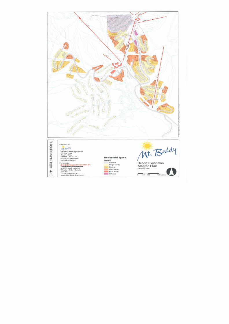
8/12/2019 Mount Baldy
http://slidepdf.com/reader/full/mount-baldy 127/322
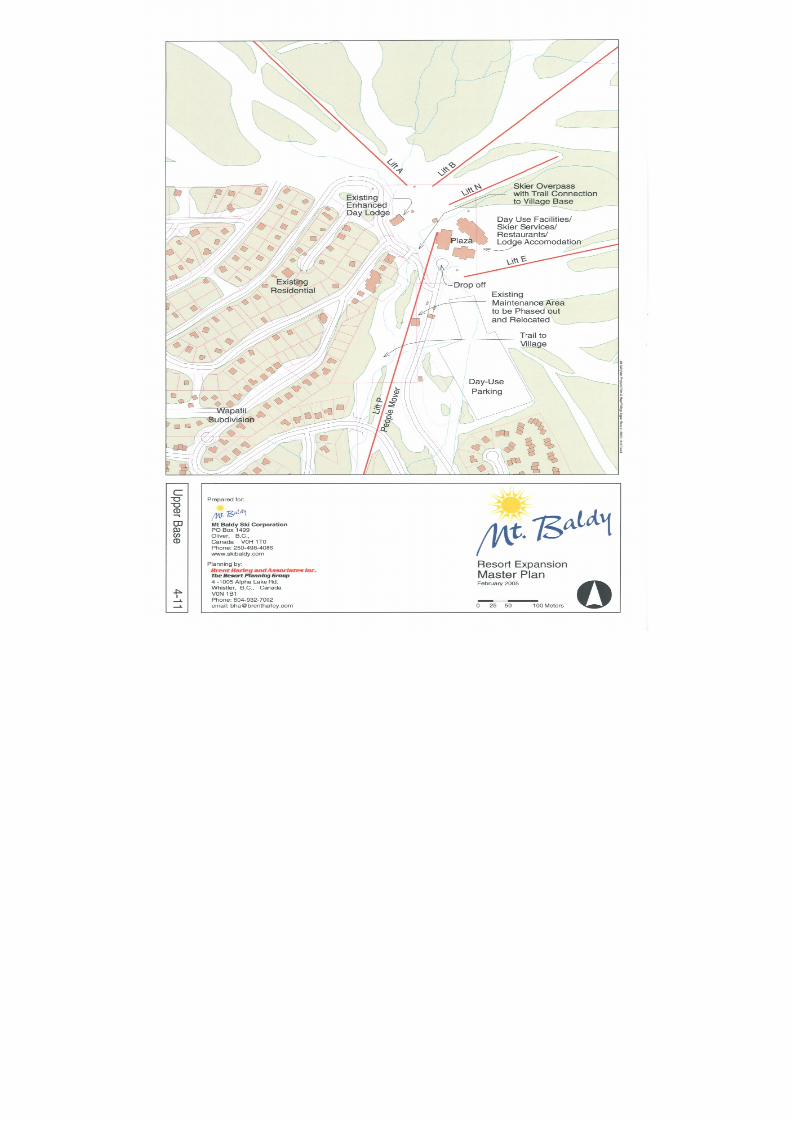
8/12/2019 Mount Baldy
http://slidepdf.com/reader/full/mount-baldy 128/322
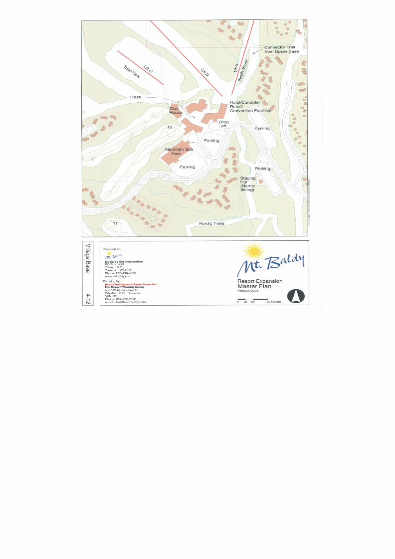
8/12/2019 Mount Baldy
http://slidepdf.com/reader/full/mount-baldy 129/322
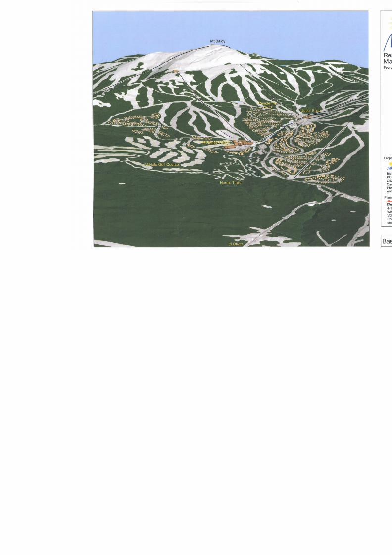
8/12/2019 Mount Baldy
http://slidepdf.com/reader/full/mount-baldy 130/322
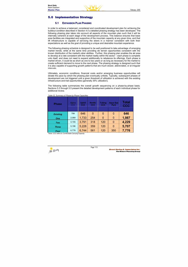
8/12/2019 Mount Baldy
http://slidepdf.com/reader/full/mount-baldy 131/322
Mount BaldyResort Expansion
Master Plan February 2005
Page 113 Brent Harley & Associates Inc.
The Resort Planning Group
55..00 IImmpplleemmeennttaattiioonn SSttr r aatteeggyy
55..11 EEXXPPAANNSSIIOONN PPLLAANN PPHHAASSIINNGG
In order to achieve a balanced, considered and coordinated development plan for achieving the
buildout condition described in Section 4.0 a detailed phasing strategy has been developed. Thefollowing phasing plan takes into account all aspects of the mountain plan such that it will beinternally coherent at each stage of the development process. This balance ensures that basearea facilities are integrated and supportive of the mountain capacity at any given time, and thatlift infrastructure is capable of servicing the skiers in a manner consistent with both theirexpectations as well as the goal of providing a unique and desirable mountain experience.
The following phasing schedule is designed to be well positioned to take advantage of emergingmarket trends, while at the same time providing ski terrain opportunities consistent with theknown distribution of the market’s skier abilities. Further, this phasing plan enables the ski areato develop at a rate consistent with the market reality within the sector – each phase is completeunto itself, and does not need to expand additionally to rebalance its offerings. Each phase is
market driven, it could be as short as one to two years or as long as necessary for the market tocreate sufficient demand to move to the next phase. The phasing strategy is designed such thatit is also capable of supporting growth patterns that are much slower, abbreviated, or at irregularintervals.
Ultimately, economic conditions, financial costs and/or emerging business opportunities willdictate the pace by which the phasing plan eventually unfolds. Typically, subsequent phases ofdevelopment are not triggered until a given threshold of utilization is achieved with the existinginfrastructure and trail opportunities (generally 35% utilization).
The following table summarizes the overall growth sequencing on a phase-by-phase basis.Sections 5.2 through 5.5 present the detailed development patterns of each individual phase for
additional review.
Table 32. Summary of Phase-by-Phase Capacities
Phase Alpine
CCC UphillCCC
NordicCCC
TubingCCC
Aqua SpaPark
TotalCCC
Existing 799 646 0 0 0 646
One 2,069 1,733 254 0 0 1,987
Two 4,155 3,791 318 120 0 4,229
Three 5,196 5,228 359 120 0 5,707
Four 6,778 6,744 561 120 350 7,776*Note: CCC refers to Comfortable Carrying Capacity
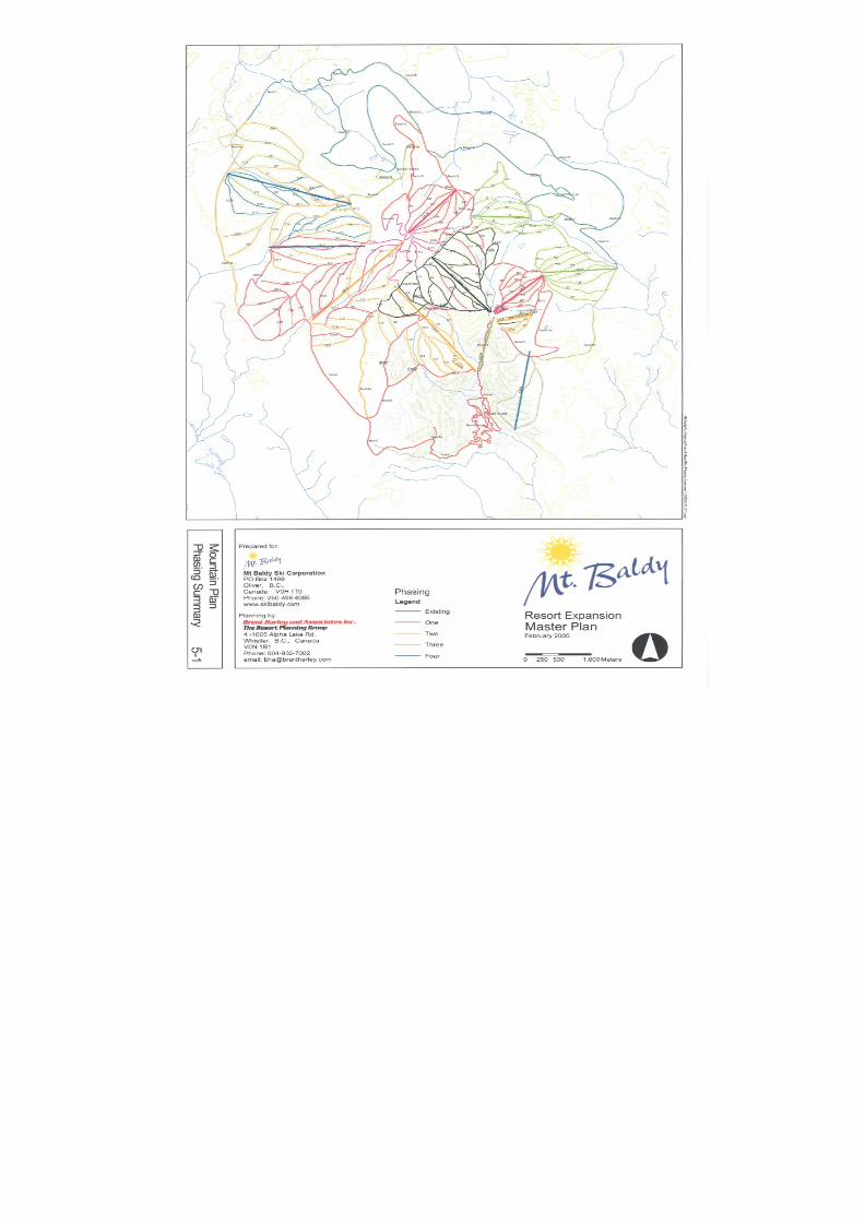
8/12/2019 Mount Baldy
http://slidepdf.com/reader/full/mount-baldy 132/322
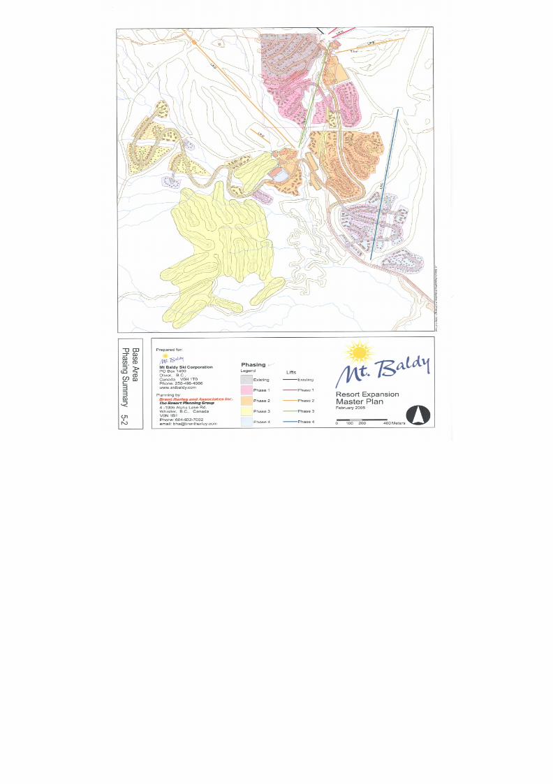
8/12/2019 Mount Baldy
http://slidepdf.com/reader/full/mount-baldy 133/322
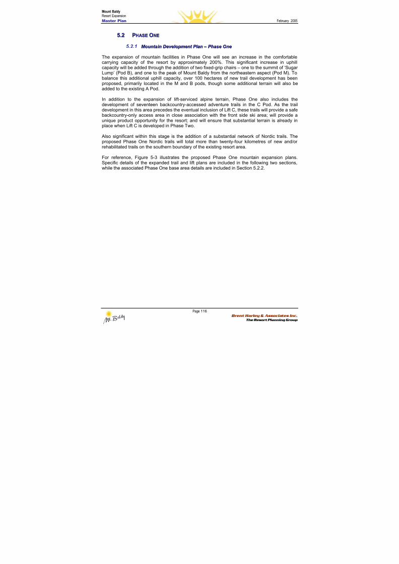
8/12/2019 Mount Baldy
http://slidepdf.com/reader/full/mount-baldy 134/322
Mount BaldyResort Expansion
Master Plan February 2005
Page 116 Brent Harley & Associates Inc.
The Resort Planning Group
55..22 PPHHAASSEE OONNEE
5.2.1 M M oou u nnt t aai i nn DDeev v eel l oo p pmmeennt t P P l l aann – – P P hhaassee O O nnee
The expansion of mountain facilities in Phase One will see an increase in the comfortable
carrying capacity of the resort by approximately 200%. This significant increase in uphillcapacity will be added through the addition of two fixed-grip chairs – one to the summit of ‘SugarLump’ (Pod B), and one to the peak of Mount Baldy from the northeastern aspect (Pod M). Tobalance this additional uphill capacity, over 100 hectares of new trail development has beenproposed, primarily located in the M and B pods, though some additional terrain will also beadded to the existing A Pod.
In addition to the expansion of lift-serviced alpine terrain, Phase One also includes thedevelopment of seventeen backcountry-accessed adventure trails in the C Pod. As the traildevelopment in this area precedes the eventual inclusion of Lift C, these trails will provide a safebackcountry-only access area in close association with the front side ski area; will provide aunique product opportunity for the resort; and will ensure that substantial terrain is already in
place when Lift C is developed in Phase Two.
Also significant within this stage is the addition of a substantial network of Nordic trails. Theproposed Phase One Nordic trails will total more than twenty-four kilometres of new and/orrehabilitated trails on the southern boundary of the existing resort area.
For reference, Figure 5-3 illustrates the proposed Phase One mountain expansion plans.Specific details of the expanded trail and lift plans are included in the following two sections,while the associated Phase One base area details are included in Section 5.2.2.
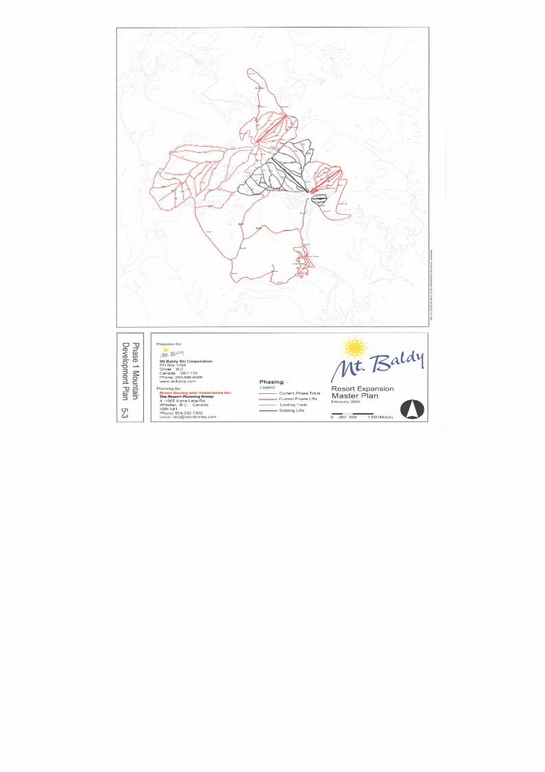
8/12/2019 Mount Baldy
http://slidepdf.com/reader/full/mount-baldy 135/322
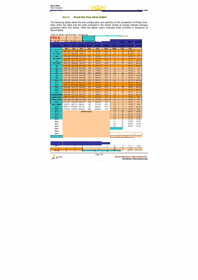
8/12/2019 Mount Baldy
http://slidepdf.com/reader/full/mount-baldy 136/322
Mount BaldyResort Expansion
Master Plan February 2005
Page 118 Brent Harley & Associates Inc.
The Resort Planning Group
55..22..11..11 PPHHAASSEE OONNEE TTRRAAIILL DDEEVVEELLOOPPMMEENNTT
The following tables detail the trail configuration and specifics at the completion of Phase One.Note within the table that the trails indicated in the darker shade of orange indicate changesproposed within this phase, while the lighter colour indicates trails currently in existence atMount Baldy.
Table 33. Alpine Trail Inventory – Phase One
POD A
Run Top Bottom Horiz. Vertical Slope Average Ave. Max. Ability
Number Elev. Elev. Length Drop Length Width Area Grade Grade Level
(m) (m) (m) (m) (m) (m) (Ha) (%) (%)
A1 2062.46 1915.39 458.80 147 483.29 80.0 3.9 32 40.70% Int
A1 - EXT 1913.72 1905.36 30.06 8 31.27 10.0 0.0 28 40.70% Int
A2 2080.48 1878.53 587.90 202 624.94 65.0 4.1 34 42.9% Int
A2 - EXT 1872.66 1835.30 107.19 37 113.58 65.0 0.7 35 42.9% Int
A3 2096.22 1862.16 645.32 234 688.45 70.0 4.8 36 50.1% Adv Int
A3 - EXT 1857.78 1829.40 120.21 28 123.75 50.0 0.6 24 50.1% Adv IntA4 2107.53 1800.38 967.82 307 1020.18 70.0 7.1 32 56.5% Adv Int
A5 1983.62 1853.79 397.95 130 419.83 50.0 2.1 33 38.1% Int
A6 2009.77 1783.83 738.43 226 775.66 50.0 3.9 31 40.9% Int
A7 2109.47 1749.36 1303.16 360 1360.06 70.0 9.5 28 44.4% Int
A8 1793.93 1742.01 232.84 52 239.69 30.0 0.7 22 30.4% Low Int
A9 2122.16 1800.00 935.00 322 988.94 40.0 4.0 34 63.6% Exp
A10 2030.58 1842.48 516.56 188 552.13 40.0 2.2 36 47.1% Adv Int
A11 2103.67 1874.71 551.76 229 603.84 50.0 3.0 41 58.5% Adv Int
A12 1907.71 1810.39 296.78 97 313.15 50.0 1.6 33 50.5% Adv Int
A13 2043.86 1827.72 753.50 216 789.56 30.0 2.4 29 45.6% Adv Int
A14 2079.98 1845.39 681.02 235 725.43 60.0 4.4 34 50.1% Adv Int
A15 2016.94 1905.17 331.12 112 351.67 50.0 1.8 34 50.1% Adv Int
STEMWINDER 1987.84 1947.51 285.70 40 289.23 20.0 0.6 14 50.0% Adv IntCABIN TRAIL 1896.53 1824.72 424.84 72 432.96 0.0 0.0 17 25.0% Nov
JOLY JACK 1917.41 1877.63 231.76 40 235.86 10.0 0.2 17 25.0% Nov
AC1 2121.98 1729.96 3255.74 392 3289.84 10.0 3.3 12 18.0% Nov
AC1 - NEW 1922.27 1802.19 1063.01 120 1073.02 20.0 2.1 11 15.0% Nov
AC2 1839.13 1813.68 237.34 25 238.84 10.0 0.2 11 10.8% adv Int
AC3 2119.22 1729.00 2910.00 390 2936.05 10.0 2.9 13 14.0% Nov
A1-a 1.4 32 40.7% Int Gl
A1-b 3.3 32 40.7% Int Gl
A1-c 0.3 32 40.7% Int Gl
A2-a 4.8 34 42.9% Int Gl
A2-b 1.3 34 42.9% Int Gl
A2-c 0.6 34 42.9% Int Gl
A2-d 0.6 34 42.9% Int GlA4-a 0.7 32 56.5% Adv Int Gl
A4-b 1.6 32 56.5% Adv Int Gl
A4-c 3.4 32 56.5% Adv Int Gl
A5-a 1.1 33 38.0% Int Gl
A7-a 1.1 28 44.0% Int Gl
A9-a 2.7 34 63.0% Exp Gl
A9-b 2.3 34 63.0% Exp Gl
A9-c 1.4 34 63.0% Exp Gl
A10-a 1.2 36 47.0% Adv Int Gl
A11-a
Gladed Areas
0.1 41 58.5% Adv Int Gl
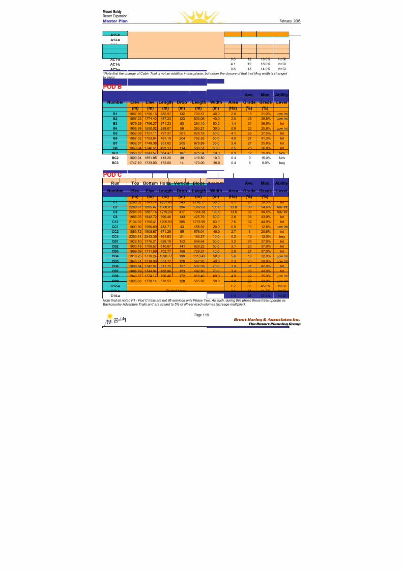
8/12/2019 Mount Baldy
http://slidepdf.com/reader/full/mount-baldy 137/322
Mount BaldyResort Expansion
Master Plan February 2005
Page 119 Brent Harley & Associates Inc.
The Resort Planning Group
A11-b 5.0 41 58.5% Adv Int Gl
A13-a 3.2 29 45.6% Adv Int Gl
A14-a 6.2 34 50.1% Adv Int Gl
A15-a 2.4 34 50.1% Adv Int Gl
A15-b 2.4 34 50.0% Adv Int Gl
AC1-a 0.5 12 18.0% Int Gl
AC1-b 4.1 12 18.0% Int GlAC3-a 0.8 13 14.0% Int Gl
*Note that the change of Cabin Trail is not an addition in this phase, but rather the closure of that trail (Avg width is changedto zero)
POD B
Run Top Bottom Horiz. Vertical Slope Average Ave. Max. Ability
Number Elev. Elev. Length Drop Length Width Area Grade Grade Level
(m) (m) (m) (m) (m) (m) (Ha) (%) (%)
B1 1887.96 1756.15 682.97 132 700.57 40.0 2.8 19 31.0% Low Int
B2 1897.22 1774.42 487.23 123 503.05 40.0 2.0 25 28.5% Low Int
B3 1879.29 1796.27 271.23 83 284.10 50.0 1.4 31 36.5% Int
B4 1908.89 1850.62 288.67 58 295.27 30.0 0.9 20 25.8% Low IntB5 1952.09 1751.11 797.27 201 828.18 50.0 4.1 25 37.5% Int
B6 1957.02 1753.04 761.19 204 792.52 50.0 4.0 27 41.3% Int
B7 1952.87 1748.36 951.62 205 978.89 35.0 3.4 21 35.9% Int
B8 1860.04 1746.51 493.13 114 509.51 50.0 2.5 23 36.8% Int
BC1 1950.82 1843.57 864.47 107 875.94 10.0 0.9 12 15.0% Nov
BC2 1890.94 1851.95 413.20 39 419.80 10.0 0.4 9 15.0% Nov
BC3 1747.10 1733.00 172.00 14 173.00 30.0 0.4 6 8.0% beg
POD C
Run Top Bottom Horiz. Vertical Slope Average Ave. Max. Ability
Number Elev. Elev. Length Drop Length Width Area Grade Grade Level
(m) (m) (m) (m) (m) (m) (Ha) (%) (%)
C1 2288.32 1745.74 2637.85 543 2716.17 30.0 8.1 21 39.5% Int
C2 2289.67 1895.47 1308.01 394 1382.63 100.0 13.8 30 54.6% Adv Int
C5 2284.03 1867.16 1279.24 417 1354.38 100.0 13.5 33 49.4% Adv Int
C8 1986.03 1842.72 399.46 143 425.79 60.0 2.6 36 43.9% Int
C12 2134.92 1750.41 1205.93 385 1273.96 60.0 7.6 32 44.9% Int
CC1 1993.80 1950.69 453.71 43 456.92 20.0 0.9 10 12.8% Low Int
CC2 1863.72 1808.67 671.26 55 676.04 40.0 2.7 8 20.6% int
CC4 2263.14 2242.36 161.63 21 165.27 10.0 0.2 13 12.0% beg
CB1 1928.10 1776.21 628.19 152 649.64 50.0 3.2 24 37.0% Int
CB2 1900.18 1759.57 610.67 141 629.22 50.0 3.1 23 37.0% Int
CB3 1899.69 1711.89 702.77 188 728.24 40.0 2.9 27 37.0% Int
CB4 1918.25 1719.24 1090.77 199 1113.43 50.0 5.6 18 32.0% Low Int
CB5 1846.51 1718.08 551.77 128 567.93 40.0 2.3 23 28.0% Low Int
CB6 1898.84 1742.07 511.75 157 537.09 70.0 3.8 31 42.0% Int
CB7 1896.79 1744.04 465.98 153 492.80 70.0 3.4 33 44.0% Int
CB8 1946.57 1774.17 796.46 172 816.40 60.0 4.9 22 35.0% Low Int
CB9 1906.63 1778.14 570.53 128 585.92 50.0 2.9 23 33.0% Low Int
C12-a 1.2 32 45.0% Int Gl
C13-a 2.4 34 41.7% Int Gl
C14-a
Gladed Areas
1.9 26 37.4% Int Gl
Note that all noted P1 - Pod C trails are not lift-serviced until Phase Two. As such, during this phase these trails operate asBackcountry Adventure Trails and are scaled to 5% of lift-serviced volumes (acreage multiplier).
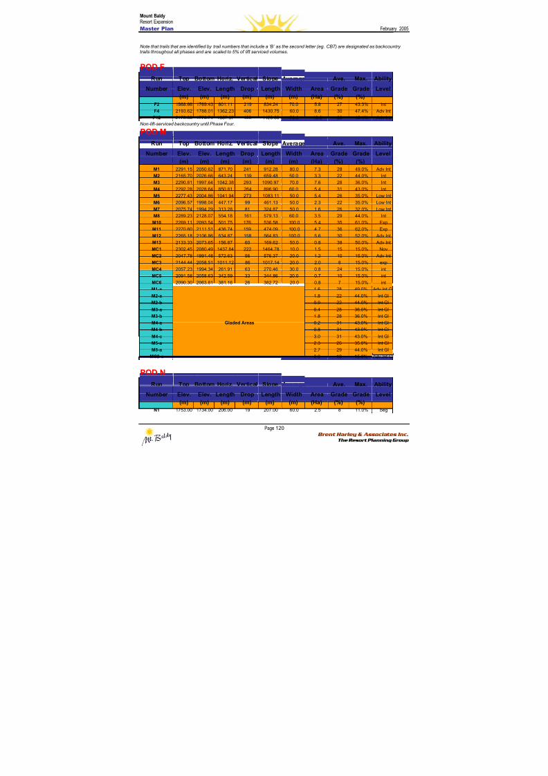
8/12/2019 Mount Baldy
http://slidepdf.com/reader/full/mount-baldy 138/322
Mount BaldyResort Expansion
Master Plan February 2005
Page 120 Brent Harley & Associates Inc.
The Resort Planning Group
Note that trails that are identified by trail numbers that include a ‘B’ as the second letter (eg. CB7) are designated as backcountrytrails throughout all phases and are scaled to 5% of lift serviced volumes.
POD F
Run Top Bottom Horiz. Vertical Slope Average Ave. Max. Ability
Number Elev. Elev. Length Drop Length Width Area Grade Grade Level (m) (m) (m) (m) (m) (m) (Ha) (%) (%)
F2 1988.66 1769.43 801.11 219 834.24 70.0 5.8 27 43.3% Int
F4 2193.62 1788.01 1362.23 406 1430.75 60.0 8.6 30 47.4% Adv Int
F12 2178.30 1770.74 1357.07 408 1423.63 70.0 10.0 30 45.4% Adv Int
Non-lift-serviced backcountry until Phase Four.
POD M
Run Top Bottom Horiz. Vertical Slope Average Ave. Max. Ability
Number Elev. Elev. Length Drop Length Width Area Grade Grade Level
(m) (m) (m) (m) (m) (m) (Ha) (%) (%)
M1 2291.15 2050.62 871.70 241 912.28 80.0 7.3 28 49.0% Adv Int
M2 2165.70 2026.66 643.24 139 659.48 50.0 3.3 22 44.0% IntM3 2290.81 1997.64 1042.38 293 1090.97 70.0 7.6 28 36.0% Int
M4 2292.28 2028.64 850.81 264 896.90 60.0 5.4 31 43.0% Int
M5 2277.43 2004.86 1041.94 273 1083.11 50.0 5.4 26 35.0% Low Int
M6 2096.57 1998.04 447.17 99 461.13 50.0 2.3 22 35.0% Low Int
M7 2075.74 1994.29 313.28 81 324.87 50.0 1.6 26 32.0% Low Int
M8 2289.23 2128.07 554.18 161 579.13 60.0 3.5 29 44.0% Int
M10 2269.11 2093.54 501.75 176 536.58 100.0 5.4 35 61.0% Exp
M11 2270.60 2111.51 436.74 159 474.09 100.0 4.7 36 62.0% Exp
M12 2265.18 2106.86 534.87 158 564.83 100.0 5.6 30 52.0% Adv Int
M13 2133.33 2073.65 156.87 60 169.62 50.0 0.8 38 50.0% Adv Int
MC1 2302.45 2080.49 1437.84 222 1464.78 10.0 1.5 15 15.0% Nov
MC2 2047.78 1991.48 572.63 56 576.37 20.0 1.2 10 15.0% Adv Int
MC3 2144.44 2058.51 1011.12 86 1017.14 20.0 2.0 8 15.0% expMC4 2057.23 1994.34 261.91 63 270.46 30.0 0.8 24 15.0% int
MC5 2091.58 2058.63 342.59 33 344.86 20.0 0.7 10 15.0% int
MC6 2090.30 2063.81 381.16 26 382.72 20.0 0.8 7 15.0% int
M1-a 1.6 28 49.0% Adv Int Gl
M2-a 1.8 22 44.0% Int Gl
M2-b 0.9 22 44.0% Int Gl
M3-a 0.4 28 36.0% Int Gl
M3-b 1.8 28 36.0% Int Gl
M4-a 0.2 31 43.0% Int Gl
M4-b 0.8 31 43.0% Int Gl
M4-c 3.0 31 43.0% Int Gl
M5-a 2.3 26 35.0% Int Gl
M8-a 2.7 29 44.0% Int GlMC2-a
Gladed Areas
0.9 10 15.0% Adv Int Gl
POD N
Run Top Bottom Horiz. Vertical Slope Average Ave. Max. Ability
Number Elev. Elev. Length Drop Length Width Area Grade Grade Level
(m) (m) (m) (m) (m) (m) (Ha) (%) (%)
N1 1753.00 1734.00 206.00 19 207.00 60.0 2.5 8 11.0% beg
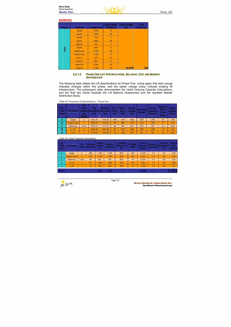
8/12/2019 Mount Baldy
http://slidepdf.com/reader/full/mount-baldy 139/322
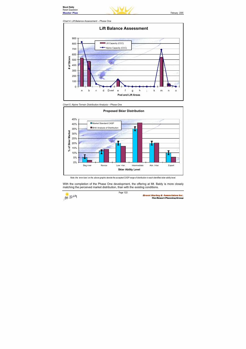
8/12/2019 Mount Baldy
http://slidepdf.com/reader/full/mount-baldy 140/322
Mount BaldyResort Expansion
Master Plan February 2005
Page 122 Brent Harley & Associates Inc.
The Resort Planning Group
Chart 4. Lift Balance Assessment – Phase One
Lift Balance Assessment
0
100
200
300
400
500
600
700
800900
a b c d D-ext e f g h j k m n o
Pod and Lift Areas
# o f S k i e r s
Lift Capacity (CCC)
Alpine Capacity (CCC)
Chart 5. Alpine Terrain Distribution Analysis – Phase One
Proposed Skier Distribution
0%
5%
10%
15%
20%
25%
30%
35%
40%
45%
Beginner Novice Low Inter. Intermediate Adv. Inter. Expert
Skier Ability Level
% o f S k i e r M a r k e t
Market Standard CASP
BHA Analysis of Distribution
Note: the ‘error bars’ on the above graphic denote the accepted CASP range of distribution in each identified skier ability level.
With the completion of the Phase One development, the offering at Mt. Baldy is more closelymatching the perceived market distribution, than with the existing conditions.

8/12/2019 Mount Baldy
http://slidepdf.com/reader/full/mount-baldy 141/322
Mount BaldyResort Expansion
Master Plan February 2005
Page 123 Brent Harley & Associates Inc.
The Resort Planning Group
5.2.2 BBaassee A Ar r eeaa DDeev v eel l oo p pmmeennt t P P l l aann – – P P hhaassee O O nnee
The first phase of base area development sees the refocusing and reorientation of the existingUpper Base as the establishment of a variety of complementary resort residential
accommodation. The total amount of built space and the total number of bed units added will bein balance with the designed resort facilities’ comfortable capacity of 1,987 guests per day.
Upper BaseOver the course of the Phase One development period, two new base lodge buildings will beadded to the Upper Base. In an incremental fashion, the shortcomings of the existing day lodgewill be addressed and will provide both enough built space to accommodate the needs andexpectations of Mt. Baldy’s visitors and residents, but also maintain a careful balance with theexpanded capacity of the mountain’s facilities. Currently, the first new lodge is being designedfor construction during the summer of 2005. The intent is to expand and improve the day useoffering at the resort. Specific attention is being paid to establishing new space for active socialgathering. This will focus on new restaurant, cafeteria and lounge spaces along with some multi-use/flex space as well as upgraded washrooms. Attention will further be paid to ensuring thatthe new space establishes and reinforces the envisioned ambiance of authentic mountainretreat values.
Subsequently, a second day lodge building will be developed. The amount of space created willbe consistent and balanced with the capacity requirements as determined by the expansion ofthe mountain facilities. Specifically, approximately 3,800 square metres of space will be in placewithin the Upper Base area by the end of Phase One (refer to Table 36). Directly associatedwith the Upper Base development, the parking lots will be formalized within a comfortablewalking distance of the Upper Base core area. A total capacity of 670 cars will be provided forday use skiers.

8/12/2019 Mount Baldy
http://slidepdf.com/reader/full/mount-baldy 142/322
Mount BaldyResort Expansion
Master Plan February 2005
Page 124 Brent Harley & Associates Inc.
The Resort Planning Group
Table 36. Phase One Space Use Requirements
Resort Residential AccommodationPhase One will see an increase in the amount of overnight accommodation available at Mt.Baldy. While certainly adding more private beds, an emphasis will be placed on introducingadditional publicly available bed units and employee accommodation units. As such, by the endof Phase One the following accommodation totals will be in place (Refer Table 37).
Table 37. Phase One Bed Unit Summary
Single Family Units Multi-family Units RV Park Units Employee Housing Units Total Private Uphill Alpine Total Tot/Bu
Exist Com. Total BUs Exist Com. Total BUs Exist Com. Total BUs Exist Com. Total BUs Bed Units Ratio Added CCC CCC CCC Rat
123 80 203 1218 11 50 61 244 0 30 30 60 0 100 100 200 1722 75% 940
B&B Units Multi-family Units Cabin Units Hotel Rooms Total Public
Exist Com. Total BUs Exist Com. Total BUs Exist Com. Total BUs Exist Com. Total BUs Bed Units
2 10 12 120 3 55 58 232 0 25 25 100 4 50 54 108 560 25% 520
2282 1460 1733 2069 1987 1.1
Bed Units
Phase OnePrivate Beds
Public Beds
Total Phase One Bed Units
1,7332541,987
Service/FunctionExisting
(m2)
Required
(m2)
UpperVillage
Additional
m2
Village
Additional
(m2)
Restaurant 177 596 420 0Kitchen/Scramble 74 238 164 0Bar/Lounge 93 60 0 0Rest Rooms 37 318 281 0Ski School 28 99 71 0Equip Rental/Repair 74 171 97 0Retail Sales 0 139 139 0
Ski Patrol/First Aid 93 66 0 0Public Lockers 0 99 99 0Day Care/Nursery 0 213 213 0Ticket Sales 0 20 20 0 Administration 56 111 56 0Employee Lockers 37 30 0 0Subtotal 669 2,160 1,559 0Storage/Mechanical 47 151 109 0Circ./Wall/Waste 67 216 156 0Total Ski Related Space 783 2,527 1,824 0
Space/Skier 0.39 1.27 0.92 0.00
Restaurant 0 440 440 0Entertainment 0 314 314 0Retail 0 377 377 0Convention/Seminar 0 126 126 0Total Destination Space 0 1,256 1,256 0
Phase One Totals 783 3,783 3,080 0
Skier Related Space Use Requirements
Phase One Alpine Skiing Capacity:Additional Capacity:
Total CCC:
Phase One Condition
Destination Guest Related Space Use Requirements
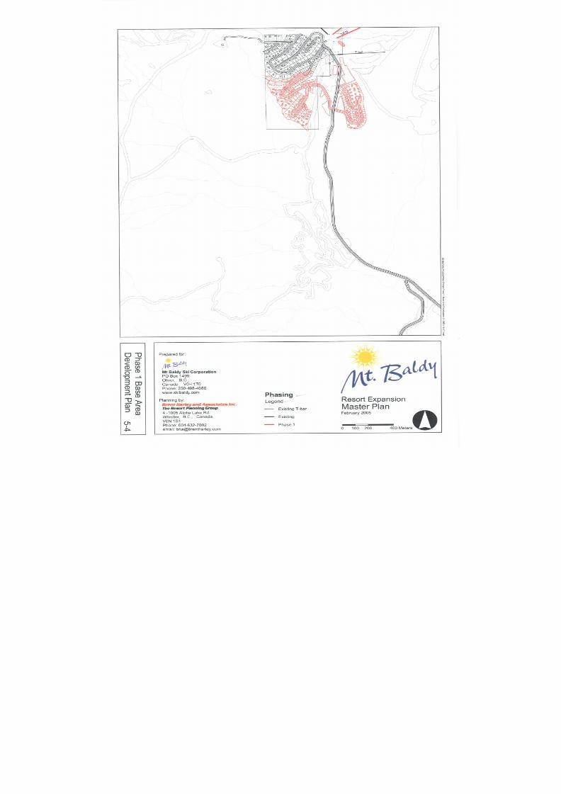
8/12/2019 Mount Baldy
http://slidepdf.com/reader/full/mount-baldy 143/322
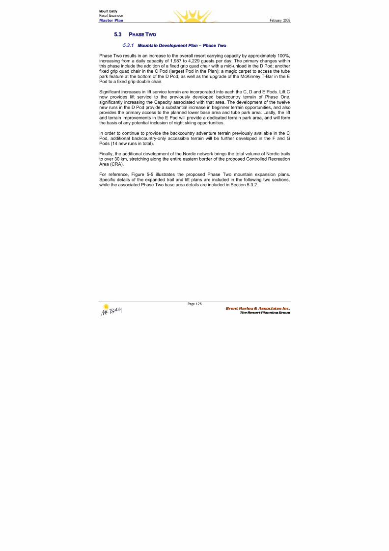
8/12/2019 Mount Baldy
http://slidepdf.com/reader/full/mount-baldy 144/322
Mount BaldyResort Expansion
Master Plan February 2005
Page 126 Brent Harley & Associates Inc.
The Resort Planning Group
55..33 PPHHAASSEE TTWWOO
5.3.1 M M oou u nnt t aai i nn DDeev v eel l oo p pmmeennt t P P l l aann – – P P hhaassee T T w w oo
Phase Two results in an increase to the overall resort carrying capacity by approximately 100%,
increasing from a daily capacity of 1,987 to 4,229 guests per day. The primary changes withinthis phase include the addition of a fixed grip quad chair with a mid-unload in the D Pod; anotherfixed grip quad chair in the C Pod (largest Pod in the Plan); a magic carpet to access the tubepark feature at the bottom of the D Pod; as well as the upgrade of the McKinney T-Bar in the EPod to a fixed grip double chair.
Significant increases in lift service terrain are incorporated into each the C, D and E Pods. Lift Cnow provides lift service to the previously developed backcountry terrain of Phase One,significantly increasing the Capacity associated with that area. The development of the twelvenew runs in the D Pod provide a substantial increase in beginner terrain opportunities, and alsoprovides the primary access to the planned lower base area and tube park area. Lastly, the liftand terrain improvements in the E Pod will provide a dedicated terrain park area, and will form
the basis of any potential inclusion of night skiing opportunities.
In order to continue to provide the backcountry adventure terrain previously available in the CPod, additional backcountry-only accessible terrain will be further developed in the F and GPods (14 new runs in total).
Finally, the additional development of the Nordic network brings the total volume of Nordic trailsto over 30 km, stretching along the entire eastern border of the proposed Controlled Recreation
Area (CRA).
For reference, Figure 5-5 illustrates the proposed Phase Two mountain expansion plans.Specific details of the expanded trail and lift plans are included in the following two sections,
while the associated Phase Two base area details are included in Section 5.3.2.
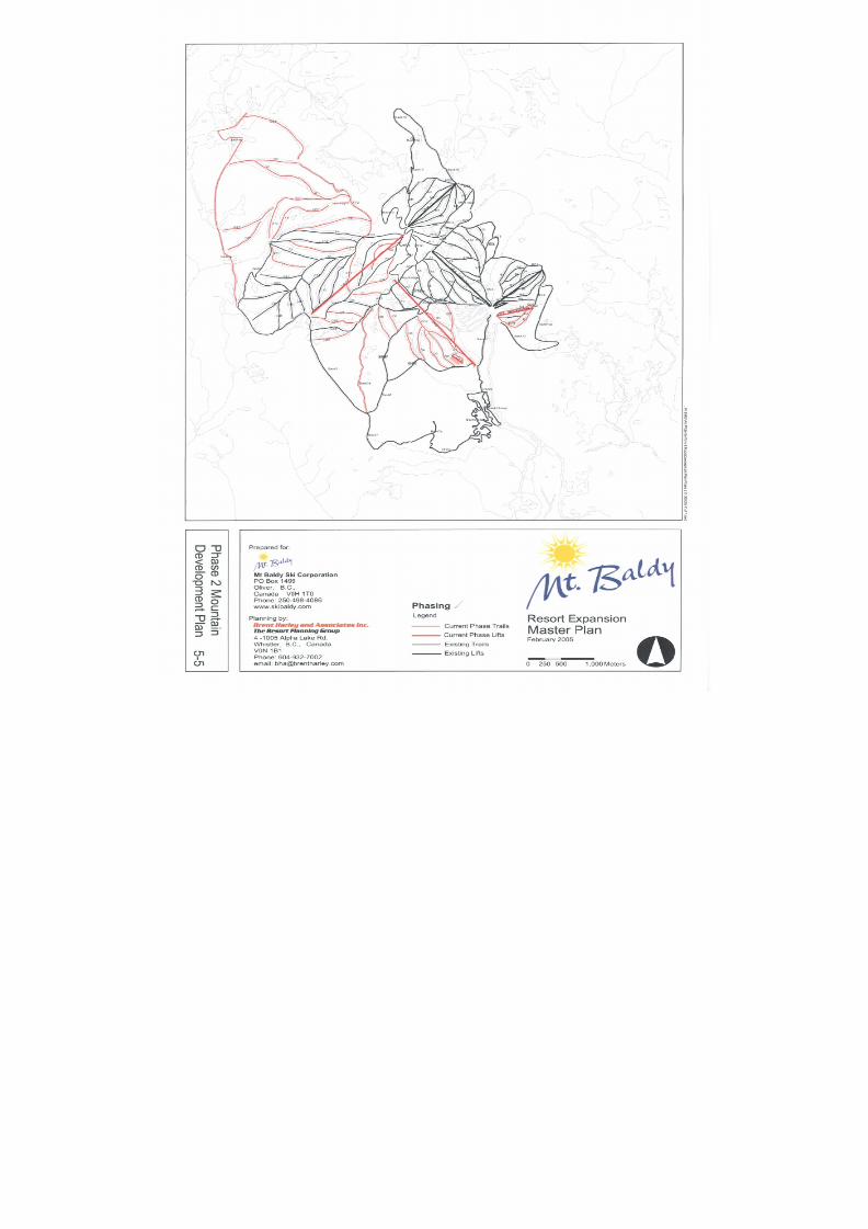
8/12/2019 Mount Baldy
http://slidepdf.com/reader/full/mount-baldy 145/322
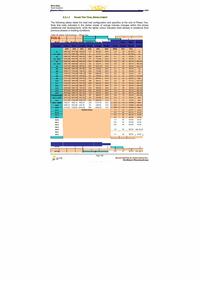
8/12/2019 Mount Baldy
http://slidepdf.com/reader/full/mount-baldy 146/322
Mount BaldyResort Expansion
Master Plan February 2005
Page 128 Brent Harley & Associates Inc.
The Resort Planning Group
55..33..11..11 PPHHAASSEE TTWWOO TTRRAAIILL DDEEVVEELLOOPPMMEENNTT
The following tables detail the total trail configuration and specifics at the end of Phase Two.Note that trails indicated in the darker shade of orange indicate changes within this phase(additional trail development), while the lighter colour indicates trails already in existence fromprevious phases or existing conditions.
Table 38. Alpine Trail Inventory – Phase Two
POD A
Run Top Bottom Horiz. Vertical Slope Average Ave. Max. Ability
Number Elev. Elev. Length Drop Length Width Area Grade Grade Level
(m) (m) (m) (m) (m) (m) (Ha) (%) (%)
A1 2062.46 1915.39 458.80 147 483.29 80.0 3.9 32 40.70% Int
A1 - EXT 1913.72 1905.36 30.06 8 31.27 10.0 0.0 28 40.70% Int
A2 2080.48 1878.53 587.90 202 624.94 65.0 4.1 34 42.9% Int
A2 - EXT 1872.66 1835.30 107.19 37 113.58 65.0 0.7 35 42.9% Int
A3 2096.22 1862.16 645.32 234 688.45 70.0 4.8 36 50.1% Adv Int
A3 - EXT 1857.78 1829.40 120.21 28 123.75 50.0 0.6 24 50.1% Adv IntA4 2107.53 1800.38 967.82 307 1020.18 70.0 7.1 32 56.5% Adv Int
A5 1983.62 1853.79 397.95 130 419.83 50.0 2.1 33 38.1% Int
A6 2009.77 1783.83 738.43 226 775.66 50.0 3.9 31 40.9% Int
A7 2109.47 1749.36 1303.16 360 1360.06 70.0 9.5 28 44.4% Int
A8 1793.93 1742.01 232.84 52 239.69 30.0 0.7 22 30.4% Low Int
A9 2122.16 1800.00 935.00 322 988.94 40.0 4.0 34 63.6% Exp
A10 2030.58 1842.48 516.56 188 552.13 40.0 2.2 36 47.1% Adv Int
A11 2103.67 1874.71 551.76 229 603.84 50.0 3.0 41 58.5% Adv Int
A12 1907.71 1810.39 296.78 97 313.15 50.0 1.6 33 50.5% Adv Int
A13 2043.86 1827.72 753.50 216 789.56 30.0 2.4 29 45.6% Adv Int
A14 2079.98 1845.39 681.02 235 725.43 60.0 4.4 34 50.1% Adv Int
A15 2016.94 1905.17 331.12 112 351.67 50.0 1.8 34 50.1% Adv Int
STEMWINDER 1987.84 1947.51 285.70 40 289.23 20.0 0.6 14 50.0% Adv IntJOLY JACK 1917.41 1877.63 231.76 40 235.86 10.0 0.2 17 25.0% Nov
AC1 2121.98 1729.96 3255.74 392 3289.84 10.0 3.3 12 18.0% Nov
AC1 - NEW 1922.27 1802.19 1063.01 120 1073.02 20.0 2.1 11 15.0% Nov
AC2 1839.13 1813.68 237.34 25 238.84 10.0 0.2 11 10.8% adv Int
AC3 2119.22 1729.00 2910.00 390 2936.05 10.0 2.9 13 14.0% Nov
A1-a 1.4 32 40.7% Int Gl
A1-b 3.3 32 40.7% Int Gl
A1-c 0.3 32 40.7% Int Gl
A2-a 4.8 34 42.9% Int Gl
A2-b 1.3 34 42.9% Int Gl
A2-c 0.6 34 42.9% Int Gl
A2-d 0.6 34 42.9% Int Gl
A4-a 0.7 32 56.5% Adv Int GlA4-b 1.6 32 56.5% Adv Int Gl
A4-c 3.4 32 56.5% Adv Int Gl
A5-a 1.1 33 38.0% Int Gl
A7-a 1.1 28 44.0% Int Gl
A9-a 2.7 34 63.0% Exp Gl
A9-b 2.3 34 63.0% Exp Gl
A9-c 1.4 34 63.0% Exp Gl
A10-a 1.2 36 47.0% Adv Int Gl
A11-a 0.1 41 58.5% Adv Int Gl
A11-b
Gladed Areas
5.0 41 58.5% Adv Int Gl
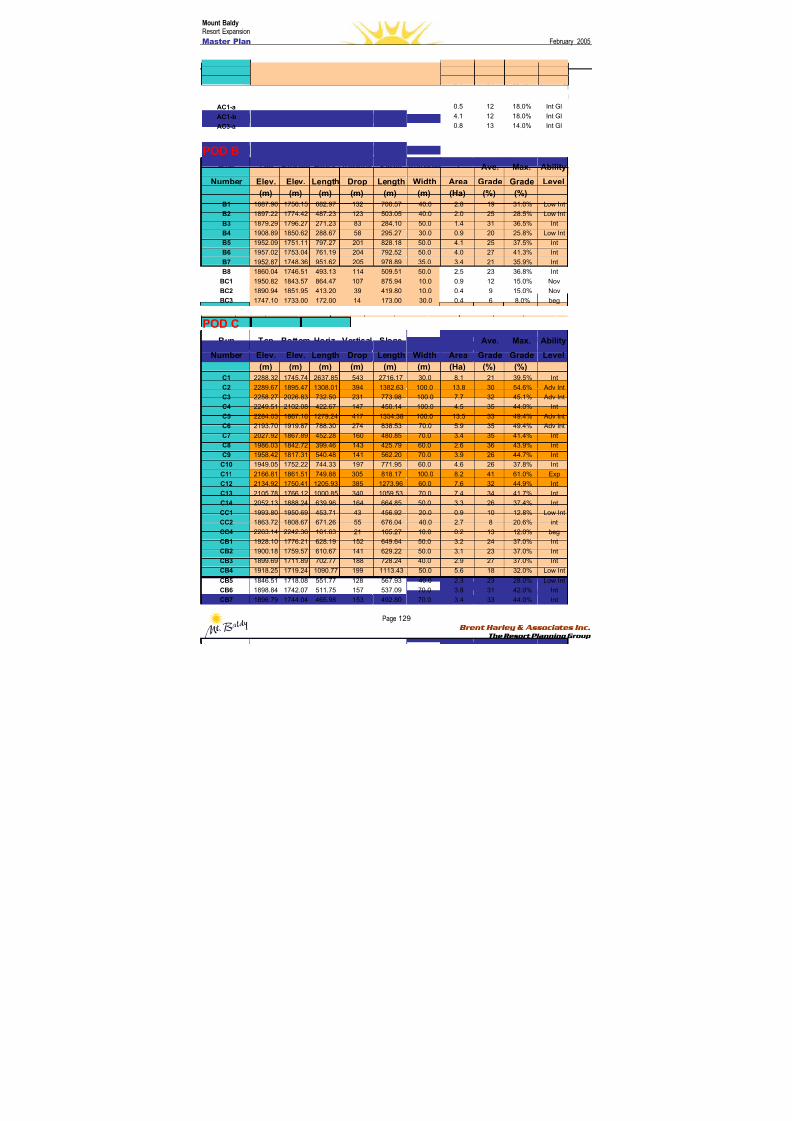
8/12/2019 Mount Baldy
http://slidepdf.com/reader/full/mount-baldy 147/322
Mount BaldyResort Expansion
Master Plan February 2005
Page 129 Brent Harley & Associates Inc.
The Resort Planning Group
A13-a 3.2 29 45.6% Adv Int Gl
A14-a 6.2 34 50.1% Adv Int Gl
A15-a 2.4 34 50.1% Adv Int Gl
A15-b 2.4 34 50.0% Adv Int Gl
AC1-a 0.5 12 18.0% Int Gl
AC1-b 4.1 12 18.0% Int Gl
AC3-a 0.8 13 14.0% Int Gl
POD B
Run Top Bottom Horiz. Vertical Slope Average Ave. Max. Ability
Number Elev. Elev. Length Drop Length Width Area Grade Grade Level
(m) (m) (m) (m) (m) (m) (Ha) (%) (%)
B1 1887.96 1756.15 682.97 132 700.57 40.0 2.8 19 31.0% Low Int
B2 1897.22 1774.42 487.23 123 503.05 40.0 2.0 25 28.5% Low Int
B3 1879.29 1796.27 271.23 83 284.10 50.0 1.4 31 36.5% Int
B4 1908.89 1850.62 288.67 58 295.27 30.0 0.9 20 25.8% Low Int
B5 1952.09 1751.11 797.27 201 828.18 50.0 4.1 25 37.5% Int
B6 1957.02 1753.04 761.19 204 792.52 50.0 4.0 27 41.3% IntB7 1952.87 1748.36 951.62 205 978.89 35.0 3.4 21 35.9% Int
B8 1860.04 1746.51 493.13 114 509.51 50.0 2.5 23 36.8% Int
BC1 1950.82 1843.57 864.47 107 875.94 10.0 0.9 12 15.0% Nov
BC2 1890.94 1851.95 413.20 39 419.80 10.0 0.4 9 15.0% Nov
BC3 1747.10 1733.00 172.00 14 173.00 30.0 0.4 6 8.0% beg
POD C
Run Top Bottom Horiz. Vertical Slope Average Ave. Max. Ability
Number Elev. Elev. Length Drop Length Width Area Grade Grade Level
(m) (m) (m) (m) (m) (m) (Ha) (%) (%)
C1 2288.32 1745.74 2637.85 543 2716.17 30.0 8.1 21 39.5% IntC2 2289.67 1895.47 1308.01 394 1382.63 100.0 13.8 30 54.6% Adv Int
C3 2258.27 2026.83 732.50 231 773.98 100.0 7.7 32 45.1% Adv Int
C4 2249.51 2102.08 422.67 147 450.14 100.0 4.5 35 44.0% Int
C5 2284.03 1867.16 1279.24 417 1354.38 100.0 13.5 33 49.4% Adv Int
C6 2193.70 1919.87 788.30 274 838.53 70.0 5.9 35 49.4% Adv Int
C7 2027.92 1867.89 452.28 160 480.85 70.0 3.4 35 41.4% Int
C8 1986.03 1842.72 399.46 143 425.79 60.0 2.6 36 43.9% Int
C9 1958.42 1817.31 540.48 141 562.20 70.0 3.9 26 44.7% Int
C10 1949.05 1752.22 744.33 197 771.95 60.0 4.6 26 37.8% Int
C11 2166.81 1861.51 749.88 305 818.17 100.0 8.2 41 61.0% Exp
C12 2134.92 1750.41 1205.93 385 1273.96 60.0 7.6 32 44.9% Int
C13 2105.78 1766.12 1000.85 340 1059.53 70.0 7.4 34 41.7% Int
C14 2052.13 1888.24 639.96 164 664.85 50.0 3.3 26 37.4% Int
CC1 1993.80 1950.69 453.71 43 456.92 20.0 0.9 10 12.8% Low Int
CC2 1863.72 1808.67 671.26 55 676.04 40.0 2.7 8 20.6% int
CC4 2263.14 2242.36 161.63 21 165.27 10.0 0.2 13 12.0% beg
CB1 1928.10 1776.21 628.19 152 649.64 50.0 3.2 24 37.0% Int
CB2 1900.18 1759.57 610.67 141 629.22 50.0 3.1 23 37.0% Int
CB3 1899.69 1711.89 702.77 188 728.24 40.0 2.9 27 37.0% Int
CB4 1918.25 1719.24 1090.77 199 1113.43 50.0 5.6 18 32.0% Low Int
CB5 1846.51 1718.08 551.77 128 567.93 40.0 2.3 23 28.0% Low Int
CB6 1898.84 1742.07 511.75 157 537.09 70.0 3.8 31 42.0% Int
CB7 1896.79 1744.04 465.98 153 492.80 70.0 3.4 33 44.0% Int
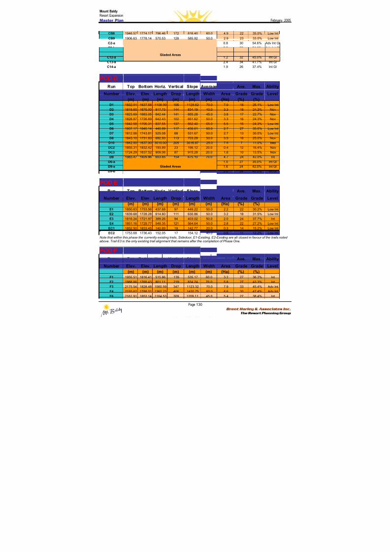
8/12/2019 Mount Baldy
http://slidepdf.com/reader/full/mount-baldy 148/322
Mount BaldyResort Expansion
Master Plan February 2005
Page 130 Brent Harley & Associates Inc.
The Resort Planning Group
CB8 1946.57 1774.17 796.46 172 816.40 60.0 4.9 22 35.0% Low Int
CB9 1906.63 1778.14 570.53 128 585.92 50.0 2.9 23 33.0% Low Int
C2-a 0.8 30 54.6% Adv Int Gl
C2-b 0.9 30 54.6% Adv Int Gl
C2-c 1.3 30 54.6% Adv Int Gl
C12-a 1.2 32 45.0% Int Gl
C13-a 2.4 34 41.7% Int GlC14-a
Gladed Areas
1.9 26 37.4% Int Gl
POD D
Run Top Bottom Horiz. Vertical Slope Average Ave. Max. Ability
Number Elev. Elev. Length Drop Length Width Area Grade Grade Level
(m) (m) (m) (m) (m) (m) (Ha) (%) (%)
D1 1832.91 1637.58 1108.99 195 1128.62 70.0 7.9 18 25.1% Low Int
D2 1818.60 1675.00 817.73 144 834.19 40.0 3.3 18 24.2% Nov
D3 1823.69 1683.05 842.44 141 855.28 45.0 3.8 17 22.7% Nov
D4 1828.87 1726.69 642.43 102 651.62 50.0 3.3 16 24.3% Nov
D5 1842.58 1705.31 837.55 137 852.40 65.0 5.5 16 24.3% Low IntD6 1957.17 1840.14 440.89 117 456.61 60.0 2.7 27 35.0% Low Int
D7 1812.06 1743.81 525.08 68 531.67 50.0 2.7 13 30.0% Low Int
D8 1845.10 1731.83 692.93 113 703.29 50.0 3.5 16 25.0% Nov
D10 1842.00 1637.00 3010.00 205 3016.97 25.0 7.5 7 11.0% beg
DC2 1855.31 1832.42 193.89 23 196.12 20.0 0.4 12 16.4% Nov
DC3 1724.29 1637.52 909.06 87 915.28 20.0 1.8 10 13.5% Nov
D9 1983.47 1829.86 653.65 154 675.10 70.0 4.7 24 42.0% Int
D6-a 1.5 27 35.0% Int Gl
D9-a 1.6 24 42.0% Int Gl
D9-b
Gladed Areas
2.0 24 42.0% Int Gl
POD E
Run Top Bottom Horiz. Vertical Slope Average Ave. Max. Ability
Number Elev. Elev. Length Drop Length Width Area Grade Grade Level
(m) (m) (m) (m) (m) (m) (Ha) (%) (%)
E1 1850.63 1753.56 437.68 97 449.22 50.0 2.2 22 30.2% Low Int
E2 1839.68 1728.28 614.60 111 630.86 50.0 3.2 18 31.5% Low Int
E3 1816.24 1721.97 389.26 94 403.02 50.0 2.0 24 37.7% Int
E4 1851.16 1729.77 548.35 121 564.64 50.0 2.8 22 27.2% Low Int
EC1 1852.50 1833.45 140.89 19 142.77 20.0 0.3 14 15.2% Low Int
EC2 1753.68 1736.43 152.05 17 154.12 40.0 0.6 11 12.2% Low Int
Note that within this phase the currently existing trails, Sidedoor, E1-Existing, E2-Existing are all closed in favour of the trails notedabove. Trail E3 is the only existing trail alignment that remains after the completion of Phase One.
POD FRun Top Bottom Horiz. Vertical Slope Average Ave. Max. Ability
Number Elev. Elev. Length Drop Length Width Area Grade Grade Level
(m) (m) (m) (m) (m) (m) (Ha) (%) (%)
F1 1955.51 1816.41 515.86 139 535.17 60.0 3.2 27 36.2% Int
F2 1988.66 1769.43 801.11 219 834.24 70.0 5.8 27 43.3% Int
F3 2175.54 1828.48 1060.59 347 1123.32 70.0 7.9 33 45.4% Adv Int
F4 2193.62 1788.01 1362.23 406 1430.75 60.0 8.6 30 47.4% Adv Int
F6 2161.91 1853.14 1164.53 309 1209.11 45.0 5.4 27 38.4% Int
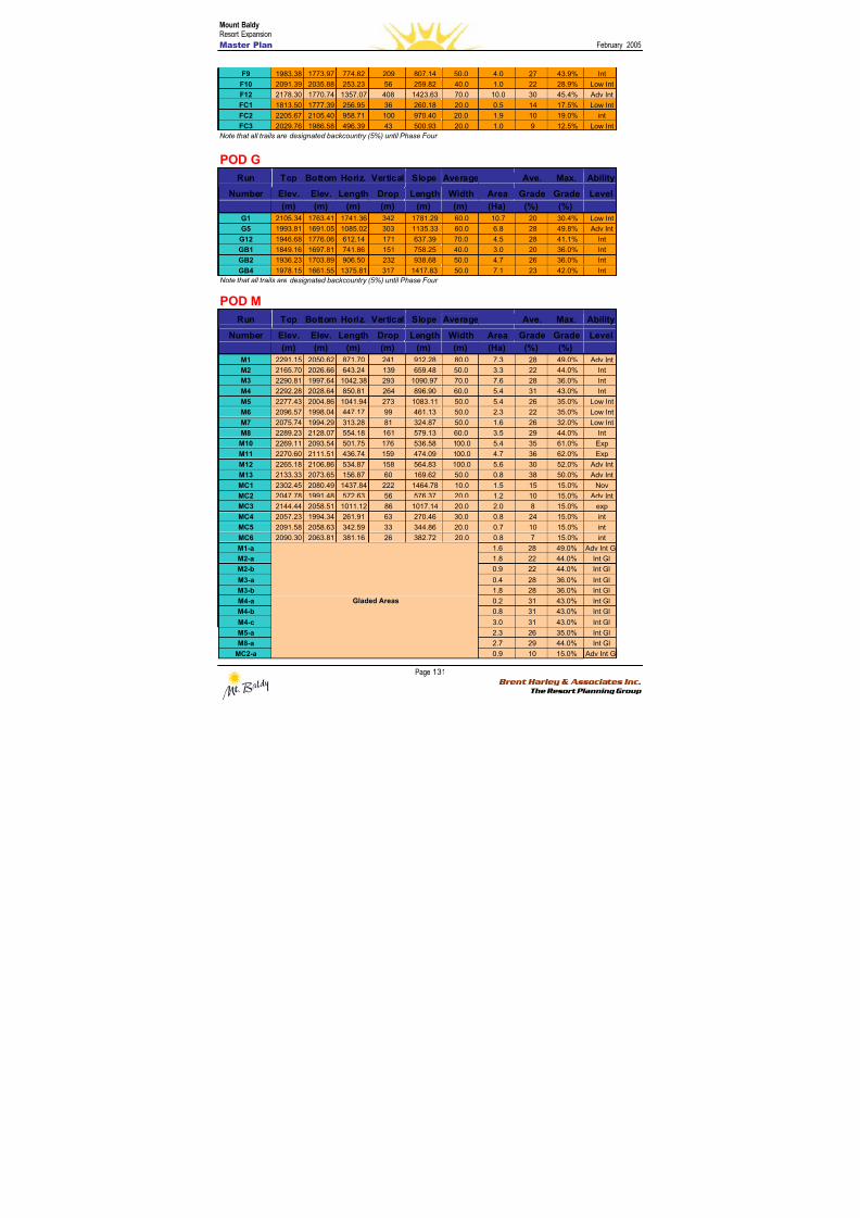
8/12/2019 Mount Baldy
http://slidepdf.com/reader/full/mount-baldy 149/322
Mount BaldyResort Expansion
Master Plan February 2005
Page 131 Brent Harley & Associates Inc.
The Resort Planning Group
F9 1983.38 1773.97 774.82 209 807.14 50.0 4.0 27 43.9% Int
F10 2091.39 2035.88 253.23 56 259.82 40.0 1.0 22 28.9% Low Int
F12 2178.30 1770.74 1357.07 408 1423.63 70.0 10.0 30 45.4% Adv Int
FC1 1813.50 1777.39 256.95 36 260.18 20.0 0.5 14 17.5% Low Int
FC2 2205.67 2105.40 958.71 100 970.40 20.0 1.9 10 19.0% int
FC3 2029.76 1986.58 496.39 43 500.93 20.0 1.0 9 12.5% Low Int
Note that all trails are designated backcountry (5%) until Phase Four
POD G
Run Top Bottom Horiz. Vertical Slope Average Ave. Max. Ability
Number Elev. Elev. Length Drop Length Width Area Grade Grade Level
(m) (m) (m) (m) (m) (m) (Ha) (%) (%)
G1 2105.34 1763.41 1741.36 342 1781.29 60.0 10.7 20 30.4% Low Int
G5 1993.81 1691.05 1085.02 303 1135.33 60.0 6.8 28 49.8% Adv Int
G12 1946.68 1776.06 612.14 171 637.39 70.0 4.5 28 41.1% Int
GB1 1849.16 1697.81 741.86 151 758.25 40.0 3.0 20 36.0% Int
GB2 1936.23 1703.89 906.50 232 938.68 50.0 4.7 26 36.0% Int
GB4 1978.15 1661.55 1375.81 317 1417.83 50.0 7.1 23 42.0% Int
Note that all trails are designated backcountry (5%) until Phase Four
POD M
Run Top Bottom Horiz. Vertical Slope Average Ave. Max. Ability
Number Elev. Elev. Length Drop Length Width Area Grade Grade Level
(m) (m) (m) (m) (m) (m) (Ha) (%) (%)
M1 2291.15 2050.62 871.70 241 912.28 80.0 7.3 28 49.0% Adv Int
M2 2165.70 2026.66 643.24 139 659.48 50.0 3.3 22 44.0% Int
M3 2290.81 1997.64 1042.38 293 1090.97 70.0 7.6 28 36.0% Int
M4 2292.28 2028.64 850.81 264 896.90 60.0 5.4 31 43.0% Int
M5 2277.43 2004.86 1041.94 273 1083.11 50.0 5.4 26 35.0% Low Int
M6 2096.57 1998.04 447.17 99 461.13 50.0 2.3 22 35.0% Low IntM7 2075.74 1994.29 313.28 81 324.87 50.0 1.6 26 32.0% Low Int
M8 2289.23 2128.07 554.18 161 579.13 60.0 3.5 29 44.0% Int
M10 2269.11 2093.54 501.75 176 536.58 100.0 5.4 35 61.0% Exp
M11 2270.60 2111.51 436.74 159 474.09 100.0 4.7 36 62.0% Exp
M12 2265.18 2106.86 534.87 158 564.83 100.0 5.6 30 52.0% Adv Int
M13 2133.33 2073.65 156.87 60 169.62 50.0 0.8 38 50.0% Adv Int
MC1 2302.45 2080.49 1437.84 222 1464.78 10.0 1.5 15 15.0% Nov
MC2 2047.78 1991.48 572.63 56 576.37 20.0 1.2 10 15.0% Adv Int
MC3 2144.44 2058.51 1011.12 86 1017.14 20.0 2.0 8 15.0% exp
MC4 2057.23 1994.34 261.91 63 270.46 30.0 0.8 24 15.0% int
MC5 2091.58 2058.63 342.59 33 344.86 20.0 0.7 10 15.0% int
MC6 2090.30 2063.81 381.16 26 382.72 20.0 0.8 7 15.0% int
M1-a 1.6 28 49.0% Adv Int GlM2-a 1.8 22 44.0% Int Gl
M2-b 0.9 22 44.0% Int Gl
M3-a 0.4 28 36.0% Int Gl
M3-b 1.8 28 36.0% Int Gl
M4-a 0.2 31 43.0% Int Gl
M4-b 0.8 31 43.0% Int Gl
M4-c 3.0 31 43.0% Int Gl
M5-a 2.3 26 35.0% Int Gl
M8-a 2.7 29 44.0% Int Gl
MC2-a
Gladed Areas
0.9 10 15.0% Adv Int Gl
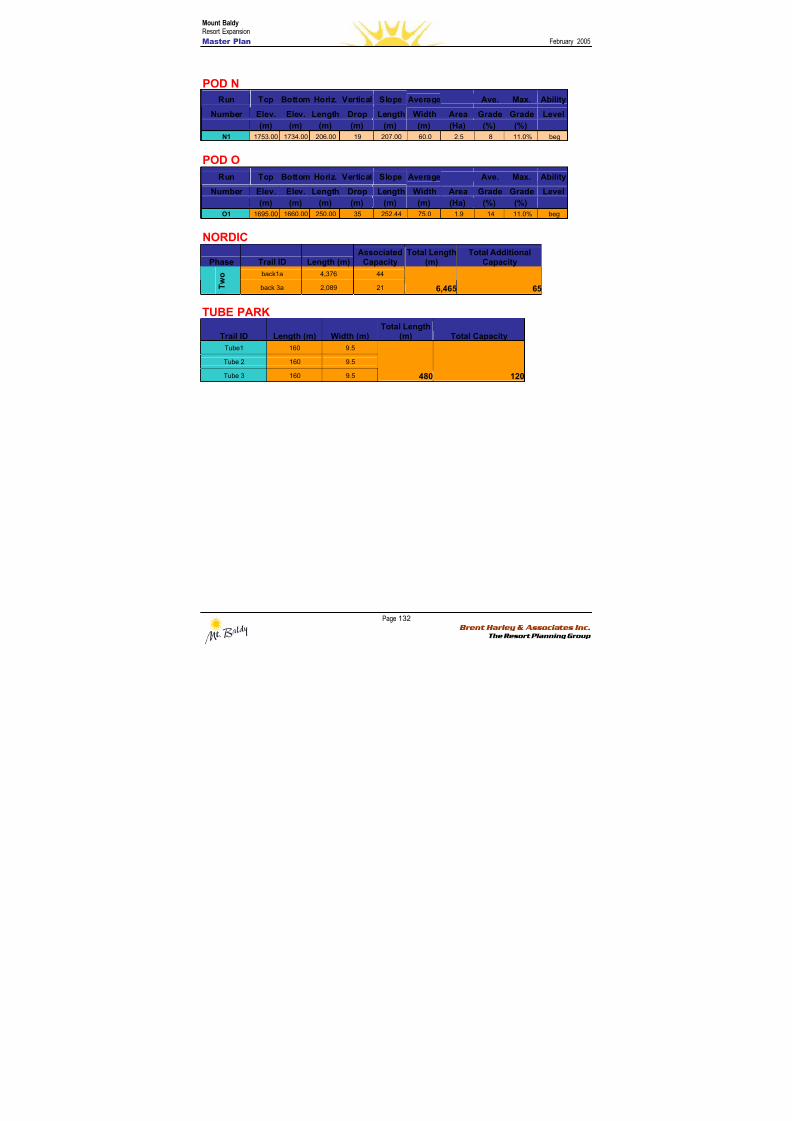
8/12/2019 Mount Baldy
http://slidepdf.com/reader/full/mount-baldy 150/322
Mount BaldyResort Expansion
Master Plan February 2005
Page 132 Brent Harley & Associates Inc.
The Resort Planning Group
POD N
Run Top Bottom Horiz. Vertical Slope Average Ave. Max. Ability
Number Elev. Elev. Length Drop Length Width Area Grade Grade Level
(m) (m) (m) (m) (m) (m) (Ha) (%) (%)N1 1753.00 1734.00 206.00 19 207.00 60.0 2.5 8 11.0% beg
POD O
Run Top Bottom Horiz. Vertical Slope Average Ave. Max. Ability
Number Elev. Elev. Length Drop Length Width Area Grade Grade Level
(m) (m) (m) (m) (m) (m) (Ha) (%) (%)
O1 1695.00 1660.00 250.00 35 252.44 75.0 1.9 14 11.0% beg
NORDIC
Phase Trail ID Length (m)Associated
CapacityTotal Length
(m)Total Additional
Capacity
back1a 4,376 44
T w o
back 3a 2,089 21 6,465 65
TUBE PARK
Trail ID Length (m) Width (m)Total Length
(m) Total Capacity
Tube1 160 9.5
Tube 2 160 9.5
Tube 3 160 9.5
480 120
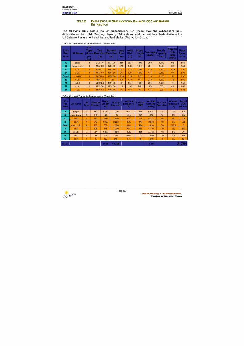
8/12/2019 Mount Baldy
http://slidepdf.com/reader/full/mount-baldy 151/322
Mount BaldyResort Expansion
Master Plan February 2005
Page 133 Brent Harley & Associates Inc.
The Resort Planning Group
55..33..11..22 PPHHAASSEE TTWWOO LLIIFFTT SSPPEECCIIFFIICCAATTIIOONNSS,, BBAALLAANNCCEE,, CCCCCC AANNDD MMAARRKKEETT
DDIISSTTRRIIBBUUTTIIOONN
The following table details the Lift Specifications for Phase Two; the subsequent tabledemonstrates the Uphill Carrying Capacity Calculations; and the final two charts illustrate theLift Balance Assessment and the resultant Market Distribution Study.
Table 39. Proposed Lift Specifications – Phase Two
Table 40. Uphill Capacity Assessment – Phase Two
Lift -PodArea
Lift NameLift
TypeVerticalRise (m)
SlopeLength
(m)
HourlyCapacity
LoadingEfficiency
(%)
VTM/Hr(000)
VerticalDemand(m/day)
Hours ofOperation
AccessReduction
(%)
ActualCCC
(skiers)
A Eagle 2 389 1,392 1,200 95% 467 5,438 7.0 12% 500
B Sugar Lump 3 212 955 1,400 95% 297 4,379 7.0 7% 418
C c Lift 3 543 2,087 1,800 95% 977 6,317 6.5 4% 920
D d Lift 4 217 1,298 2,200 85% 478 2,870 7.0 3% 962
D-ext d - ext Lift 4 220 752 2,200 85% 484 2,870 7.0 100% 0
e e Lift 2 126 575 1,200 95% 151 4,140 7.0 0% 243
M m Lift 3 301 1,089 1,600 95% 481 5,733 7.0 8% 511
N n Lift 1 30 252 500 85% 15 1,000 7.0 0% 89
O o Lift 1 35 252 500 85% 18 1,000 7.0 0% 104
Totals 8,630 12,600 43,814 3,791
Lift -PodArea
Lift Name
LiftType
(skiersper
chair)
TopElevation
(m)
BottomElevation
(m)
Vert.Rise(m)
Horiz.Dist.(m)
SlopeLength
(m)
AverageGrade
HourlyCapacity(Theor.)
Approx.RideTime(min.)
RopeSpeed(m/s)
A Eagle 2 2122.16 1733.00 389 1337 1392 29% 1,200 9.3 2.50
B Sugar Lump 3 1952.09 1733.00 219 986 1010 22% 1,400 6.7 2.50
C c Lift 3 2288.32 1745.74 543 2015 2087 27% 1,800 13.9 2.50
D d Lift 4 1855.00 1637.58 217 1280 1298 17% 2,200 9.4 2.30
D-ext d - ext Lift 4 2075.00 1855.00 220 719 752 31% 2,200 5.4 2.30
E e Lift 2 1851.16 1725 126 575 540 23% 1,200 3.6 2.50
M m Lift 3 2292.28 1991.48 301 1047 1089 29% 1,600 7.3 2.50
N n Lift 1 1753.00 1734.00 19 208 209 9% 500 4.4 0.80
O o Lift 1 1695.00 1660.00 35 250 252 14% 500 5.3 0.80
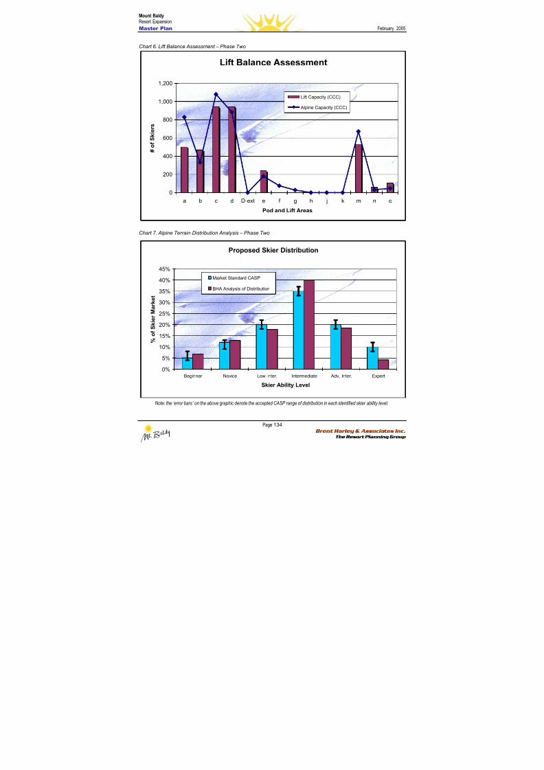
8/12/2019 Mount Baldy
http://slidepdf.com/reader/full/mount-baldy 152/322
Mount BaldyResort Expansion
Master Plan February 2005
Page 134 Brent Harley & Associates Inc.
The Resort Planning Group
Chart 6. Lift Balance Assessment – Phase Two
Lift Balance Assessment
0
200
400
600
800
1,000
1,200
a b c d D-ext e f g h j k m n o
Pod and Lift Areas
# o f S k i e r s
Lift Capacity (CCC)
Alpine Capacity (CCC)
Chart 7. Alpine Terrain Distribution Analysis – Phase Two
Proposed Skier Distribution
0%
5%
10%
15%
20%
25%
30%
35%
40%
45%
Beginner Novice Low Inter. Intermediate Adv. Inter. Expert
Skier Ability Level
% o f S k i e r M a r k e t
Market Standard CASP
BHA Analysis of Distribution
Note: the ‘error bars’ on the above graphic denote the accepted CASP range of distribution in each identified skier ability level.

8/12/2019 Mount Baldy
http://slidepdf.com/reader/full/mount-baldy 153/322
Mount BaldyResort Expansion
Master Plan February 2005
Page 135 Brent Harley & Associates Inc.
The Resort Planning Group
The distribution at the end of Phase Two again closely approximates a perfect balance, with theamount of expert terrain being the only true shortcoming.
5.3.2 BBaassee A Ar r eeaa DDeev v eel l oo p pmmeennt t P P l l aann – – P P hhaassee T T w w oo
The second phase of base area development at Mt. Baldy will see the beginning of the Villagebeing established. It will see the completion of the Upper Base and the first buildings in theVillage as well as the maintenance area being relocated from its current location to a lessprominent area. There will also be a significant addition of overnight accommodation. Tobalance with Phase Two’s increase in resort capacity of 2,242 guests/day, this phase’sdevelopment plan adds 2,150 bed units to the resort – 1,140 private and 1,010 public.
Upper BaseThe Second Phase will see the addition of the third and final building in the Upper Village.
Approximately 1,950 square metres of space will added. (See Table 41)
The VillageWith the establishment of Lift D, a new base focal point will be created. This will expand theday-use capability of Mt. Baldy while enabling the development of the resort’s first true hotelaccommodation. In total approximately 1,920 square metres of skier-related and desitinationguest oriented space will be in this phase (Refer to Table 41).
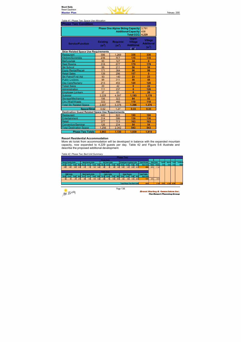
8/12/2019 Mount Baldy
http://slidepdf.com/reader/full/mount-baldy 154/322
Mount BaldyResort Expansion
Master Plan February 2005
Page 136 Brent Harley & Associates Inc.
The Resort Planning Group
Table 41. Phase Two Space Use Allocation
Resort Residential AccommodationMore ski to/ski from accommodation will be developed in balance with the expanded mountaincapacity, now expanded to 4,229 guests per day. Table 42 and Figure 5-6 illustrate anddescribe the proposed additional development.
Table 42. Phase Two Bed Unit Summary
Single Family Units Multi-family Units RV Park Units Employee Housing Units Total Private Uphill Alpine Total Tot/Built
Exist Com. Total BUs Exist Com. Total BUs Exist Com. Total BUs Exist Com. Total BUs Bed Units Ratio Added CCC CCC CCC Ratio
203 100 303 1818 61 75 136 544 30 0 30 60 100 120 220 440 2862 65% 1140
B&B Units Multi-family Units Cabin Units Hotel Rooms Total Public
Exist Com. Total BUs Exist Com. Total BUs Exist Com. Total BUs Exist Com. Total BUs Bed Units
12 15 27 270 58 100 158 632 25 75 100 400 54 80 134 268 1570 35% 1010
4432 2150 3791 4155 4229 1.05
Bed Units
Public Beds
Total Phase Two Bed Units
Private Beds
Phase Two
3,7914384,229
Service/FunctionExisting
(m2)
Required
(m2)
UpperVillage
Additional
m2
Village
Additional
(m2)
Restaurant 596 1,269 336 336Kitchen/Scramble 238 507 135 135Bar/Lounge 93 127 34 0Rest Rooms 318 677 179 179Ski School 99 211 56 56Equip Rental/Repair 171 364 96 96Retail Sales 139 296 157 0
Ski Patrol/First Aid 93 140 23 23Public Lockers 99 211 56 56Day Care/Nursery 213 453 120 120Ticket Sales 20 42 0 22 Administration 111 237 0 126Employee Lockers 37 63 0 26Subtotal 2,228 4,597 1,193 1,176Storage/Mechanical 156 322 84 82Circ./Wall/Waste 223 460 119 118Total Ski Related Space 2,607 5,378 1,396 1,376
Space/Skier 0.62 1.27 0.33 0.33
Restaurant 440 820 190 190Entertainment 314 586 136 136Retail 377 703 163 163Convention/Seminar 126 234 54 54Total Destination Space 1,256 2,342 543 543
Phase Two Totals 3,863 7,720 1,939 1,919
Total CCC:
Skier Related Space Use Requirements
Destination Guest Related Space Use Requirements
Additional Capacity:
Phase Two Condition
Phase One Alpine Skiing Capacity:
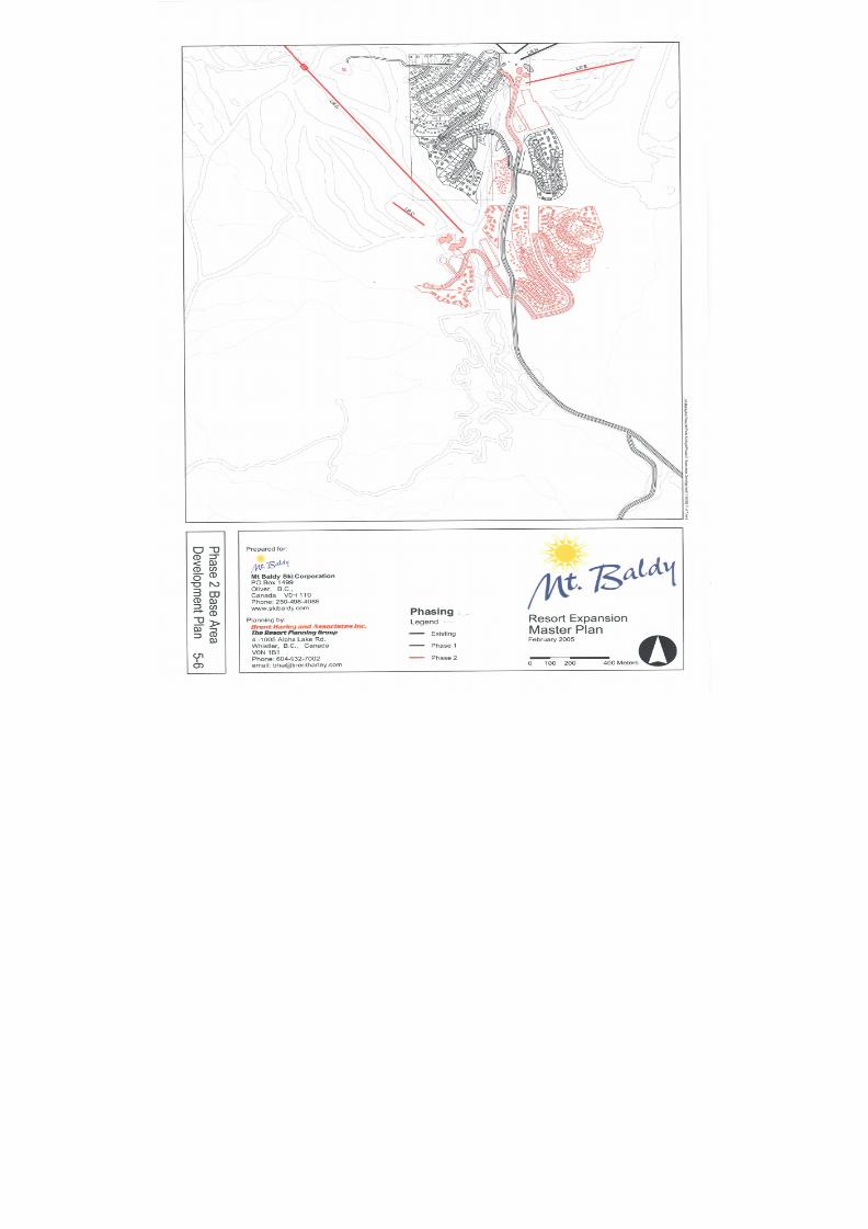
8/12/2019 Mount Baldy
http://slidepdf.com/reader/full/mount-baldy 155/322
8/12/2019 Mount Baldy
http://slidepdf.com/reader/full/mount-baldy 156/322
Mount BaldyResort Expansion
Master Plan February 2005
Page 138 Brent Harley & Associates Inc.
The Resort Planning Group
55..44 PPHHAASSEE TTHHRREEEE
5.4.1 M M oou u nnt t aai i nn DDeev v eel l oo p pmmeennt t P P l l aann – – P P hhaassee T T hhr r eeee
The additional development in Phase Three is primarily oriented to development on the eastern
aspects of the CRA. The increased mountain capacity associated with this phase is moremodest than in previous phases, increasing from 4,229 skiers/day to 5,707 (an increase ofapproximately 35%). This phase involves the addition of two new chairs – a fixed grip triple orquad serving the H Pod on the backside of ‘Sugar Lump’, and a double to serve to additionalterrain in both the J and K Pods.
The additional lift-serviced terrain totals more than 135 hectares of open trail and gladed skiingopportunities. Building on the backcountry product of previous phases, four additional open, andtwo additional gladed trails are incorporated into the G Pod.
The emerging change in the base area programming, whereby the primary destination resortcore becomes formalized in the Village, leads to the development of a people-mover lift to
connect the lower core to the day-use oriented upper base area.
Additional development of the Nordic network increases the total volume of Nordic trails toapproximately 35 km, and now completes a dedicated ‘around-the-world’ circumnavigation ofthe entire alpine area.
For reference, Figure 5-7 illustrates the proposed Phase Three mountain expansion plans.Specific details of the expanded trail and lift plans are included in the following two sections,while the associated Phase Three base area details are included in Section 5.4.2.
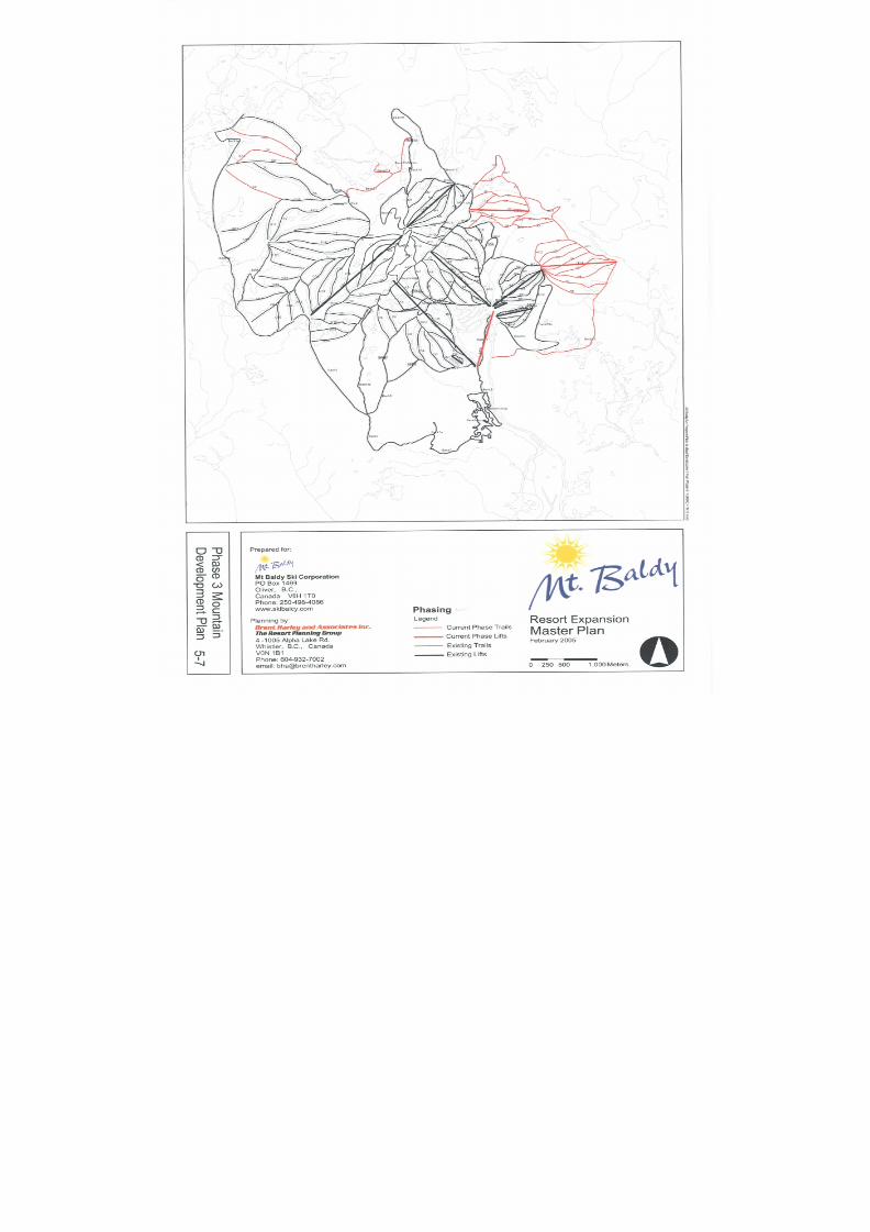
8/12/2019 Mount Baldy
http://slidepdf.com/reader/full/mount-baldy 157/322
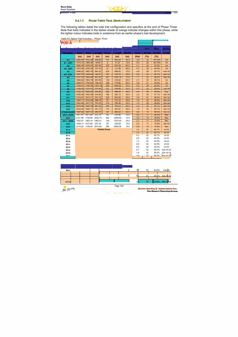
8/12/2019 Mount Baldy
http://slidepdf.com/reader/full/mount-baldy 158/322
Mount BaldyResort Expansion
Master Plan February 2005
Page 140 Brent Harley & Associates Inc.
The Resort Planning Group
55..44..11..11 PPHHAASSEE TTHHRREEEE TTRRAAIILL DDEEVVEELLOOPPMMEENNTT
The following tables detail the total trail configuration and specifics at the end of Phase Three.Note that trails indicated in the darker shade of orange indicate changes within this phase, whilethe lighter colour indicates trails in existence from an earlier phase’s trail development.
Table 43. Alpine Trail Inventory – Phase Three
POD A
Run Top Bottom Horiz. Vertical Slope Average Ave. Max. Ability
Number Elev. Elev. Length Drop Length Width Area Grade Grade Level
(m) (m) (m) (m) (m) (m) (Ha) (%) (%)
A1 2062.46 1915.39 458.80 147 483.29 80.0 3.9 32 40.70% Int
A1 - EXT 1913.72 1905.36 30.06 8 31.27 10.0 0.0 28 40.70% Int
A2 2080.48 1878.53 587.90 202 624.94 65.0 4.1 34 42.9% Int
A2 - EXT 1872.66 1835.30 107.19 37 113.58 65.0 0.7 35 42.9% Int
A3 2096.22 1862.16 645.32 234 688.45 70.0 4.8 36 50.1% Adv Int
A3 - EXT 1857.78 1829.40 120.21 28 123.75 50.0 0.6 24 50.1% Adv Int
A4 2107.53 1800.38 967.82 307 1020.18 70.0 7.1 32 56.5% Adv Int
A5 1983.62 1853.79 397.95 130 419.83 50.0 2.1 33 38.1% Int
A6 2009.77 1783.83 738.43 226 775.66 50.0 3.9 31 40.9% Int
A7 2109.47 1749.36 1303.16 360 1360.06 70.0 9.5 28 44.4% Int
A8 1793.93 1742.01 232.84 52 239.69 30.0 0.7 22 30.4% Low Int
A9 2122.16 1800.00 935.00 322 988.94 40.0 4.0 34 63.6% Exp
A10 2030.58 1842.48 516.56 188 552.13 40.0 2.2 36 47.1% Adv Int
A11 2103.67 1874.71 551.76 229 603.84 50.0 3.0 41 58.5% Adv Int
A12 1907.71 1810.39 296.78 97 313.15 50.0 1.6 33 50.5% Adv Int
A13 2043.86 1827.72 753.50 216 789.56 30.0 2.4 29 45.6% Adv Int
A14 2079.98 1845.39 681.02 235 725.43 60.0 4.4 34 50.1% Adv Int
A15 2016.94 1905.17 331.12 112 351.67 50.0 1.8 34 50.1% Adv Int
STEMWINDER 1987.84 1947.51 285.70 40 289.23 20.0 0.6 14 50.0% Adv Int
JOLY JACK 1917.41 1877.63 231.76 40 235.86 10.0 0.2 17 25.0% Nov
AC1 2121.98 1729.96 3255.74 392 3289.84 10.0 3.3 12 18.0% Nov
AC1 - NEW 1922.27 1802.19 1063.01 120 1073.02 20.0 2.1 11 15.0% Nov
AC2 1839.13 1813.68 237.34 25 238.84 10.0 0.2 11 10.8% adv Int
AC3 2119.22 1729.00 2910.00 390 2936.05 10.0 2.9 13 14.0% Nov
A1-a 1.4 32 40.7% Int Gl
A1-b 3.3 32 40.7% Int Gl
A1-c 0.3 32 40.7% Int Gl
A2-a 4.8 34 42.9% Int Gl
A2-b 1.3 34 42.9% Int Gl
A2-c 0.6 34 42.9% Int Gl
A2-d 0.6 34 42.9% Int Gl
A4-a 0.7 32 56.5% Adv Int Gl
A4-b 1.6 32 56.5% Adv Int GlA4-c 3.4 32 56.5% Adv Int Gl
A5-a 1.1 33 38.0% Int Gl
A7-a 1.1 28 44.0% Int Gl
A9-a 2.7 34 63.0% Exp Gl
A9-b 2.3 34 63.0% Exp Gl
A9-c 1.4 34 63.0% Exp Gl
A10-a 1.2 36 47.0% Adv Int Gl
A11-a 0.1 41 58.5% Adv Int Gl
A11-b 5.0 41 58.5% Adv Int Gl
A13-a
Gladed Areas
3.2 29 45.6% Adv Int Gl
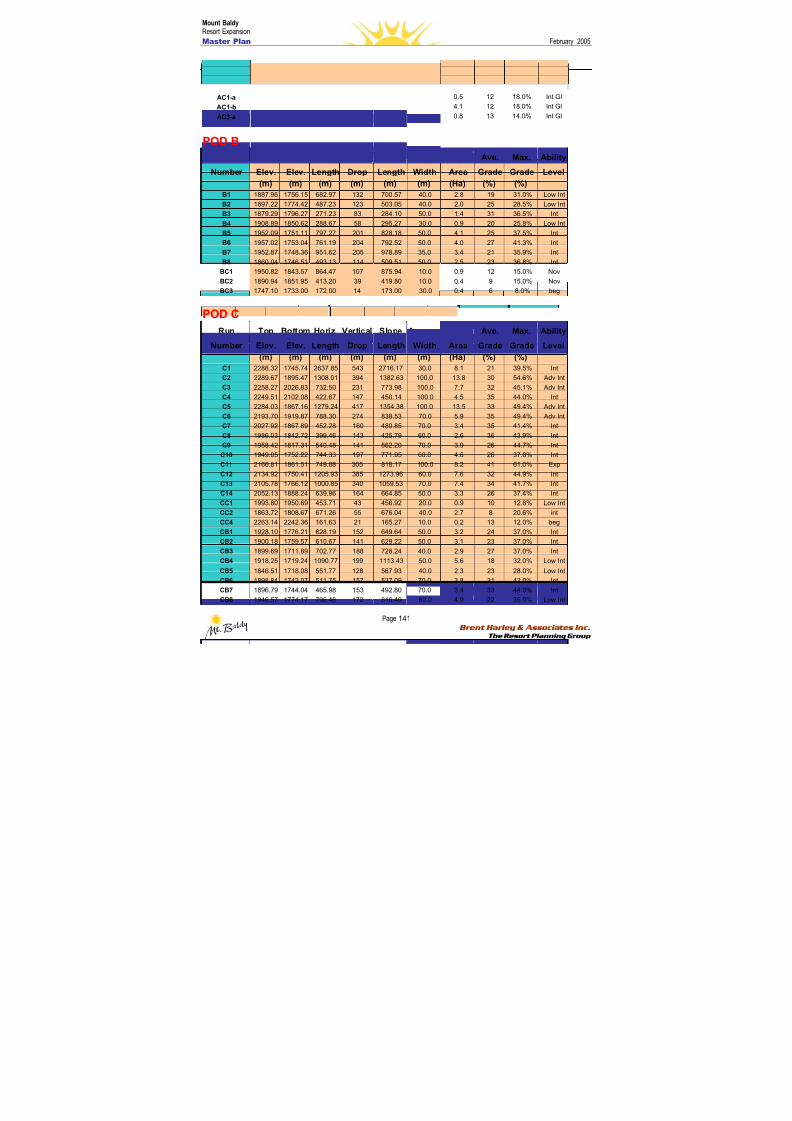
8/12/2019 Mount Baldy
http://slidepdf.com/reader/full/mount-baldy 159/322
Mount BaldyResort Expansion
Master Plan February 2005
Page 141 Brent Harley & Associates Inc.
The Resort Planning Group
A14-a 6.2 34 50.1% Adv Int Gl
A15-a 2.4 34 50.1% Adv Int Gl
A15-b 2.4 34 50.0% Adv Int Gl
AC1-a 0.5 12 18.0% Int Gl
AC1-b 4.1 12 18.0% Int Gl
AC3-a 0.8 13 14.0% Int Gl
POD B
Run Top Bottom Horiz. Vertical Slope Average Ave. Max. Ability
Number Elev. Elev. Length Drop Length Width Area Grade Grade Level
(m) (m) (m) (m) (m) (m) (Ha) (%) (%)
B1 1887.96 1756.15 682.97 132 700.57 40.0 2.8 19 31.0% Low Int
B2 1897.22 1774.42 487.23 123 503.05 40.0 2.0 25 28.5% Low Int
B3 1879.29 1796.27 271.23 83 284.10 50.0 1.4 31 36.5% Int
B4 1908.89 1850.62 288.67 58 295.27 30.0 0.9 20 25.8% Low Int
B5 1952.09 1751.11 797.27 201 828.18 50.0 4.1 25 37.5% Int
B6 1957.02 1753.04 761.19 204 792.52 50.0 4.0 27 41.3% Int
B7 1952.87 1748.36 951.62 205 978.89 35.0 3.4 21 35.9% IntB8 1860.04 1746.51 493.13 114 509.51 50.0 2.5 23 36.8% Int
BC1 1950.82 1843.57 864.47 107 875.94 10.0 0.9 12 15.0% Nov
BC2 1890.94 1851.95 413.20 39 419.80 10.0 0.4 9 15.0% Nov
BC3 1747.10 1733.00 172.00 14 173.00 30.0 0.4 6 8.0% beg
POD C
Run Top Bottom Horiz. Vertical Slope Average Ave. Max. Ability
Number Elev. Elev. Length Drop Length Width Area Grade Grade Level
(m) (m) (m) (m) (m) (m) (Ha) (%) (%)
C1 2288.32 1745.74 2637.85 543 2716.17 30.0 8.1 21 39.5% Int
C2 2289.67 1895.47 1308.01 394 1382.63 100.0 13.8 30 54.6% Adv IntC3 2258.27 2026.83 732.50 231 773.98 100.0 7.7 32 45.1% Adv Int
C4 2249.51 2102.08 422.67 147 450.14 100.0 4.5 35 44.0% Int
C5 2284.03 1867.16 1279.24 417 1354.38 100.0 13.5 33 49.4% Adv Int
C6 2193.70 1919.87 788.30 274 838.53 70.0 5.9 35 49.4% Adv Int
C7 2027.92 1867.89 452.28 160 480.85 70.0 3.4 35 41.4% Int
C8 1986.03 1842.72 399.46 143 425.79 60.0 2.6 36 43.9% Int
C9 1958.42 1817.31 540.48 141 562.20 70.0 3.9 26 44.7% Int
C10 1949.05 1752.22 744.33 197 771.95 60.0 4.6 26 37.8% Int
C11 2166.81 1861.51 749.88 305 818.17 100.0 8.2 41 61.0% Exp
C12 2134.92 1750.41 1205.93 385 1273.96 60.0 7.6 32 44.9% Int
C13 2105.78 1766.12 1000.85 340 1059.53 70.0 7.4 34 41.7% Int
C14 2052.13 1888.24 639.96 164 664.85 50.0 3.3 26 37.4% Int
CC1 1993.80 1950.69 453.71 43 456.92 20.0 0.9 10 12.8% Low Int
CC2 1863.72 1808.67 671.26 55 676.04 40.0 2.7 8 20.6% int
CC4 2263.14 2242.36 161.63 21 165.27 10.0 0.2 13 12.0% beg
CB1 1928.10 1776.21 628.19 152 649.64 50.0 3.2 24 37.0% Int
CB2 1900.18 1759.57 610.67 141 629.22 50.0 3.1 23 37.0% Int
CB3 1899.69 1711.89 702.77 188 728.24 40.0 2.9 27 37.0% Int
CB4 1918.25 1719.24 1090.77 199 1113.43 50.0 5.6 18 32.0% Low Int
CB5 1846.51 1718.08 551.77 128 567.93 40.0 2.3 23 28.0% Low Int
CB6 1898.84 1742.07 511.75 157 537.09 70.0 3.8 31 42.0% Int
CB7 1896.79 1744.04 465.98 153 492.80 70.0 3.4 33 44.0% Int
CB8 1946.57 1774.17 796.46 172 816.40 60.0 4.9 22 35.0% Low Int
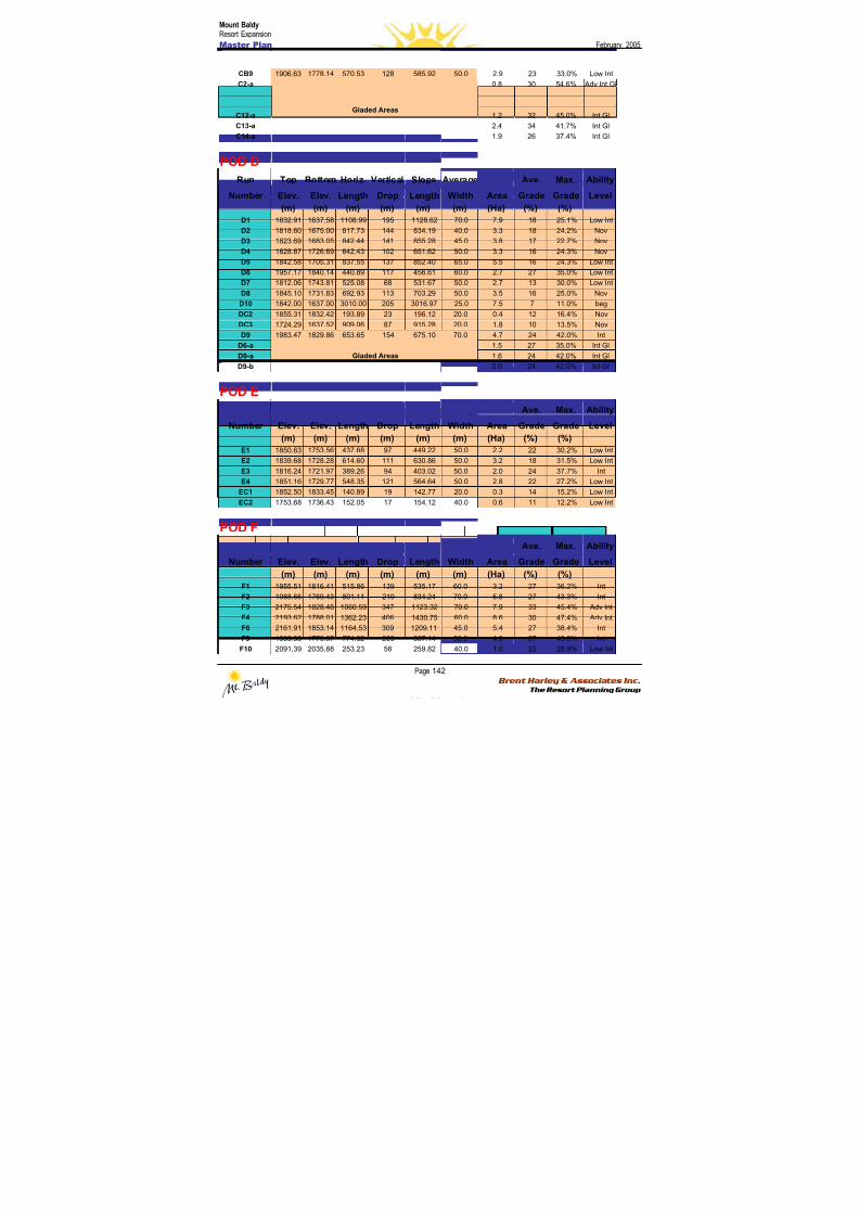
8/12/2019 Mount Baldy
http://slidepdf.com/reader/full/mount-baldy 160/322
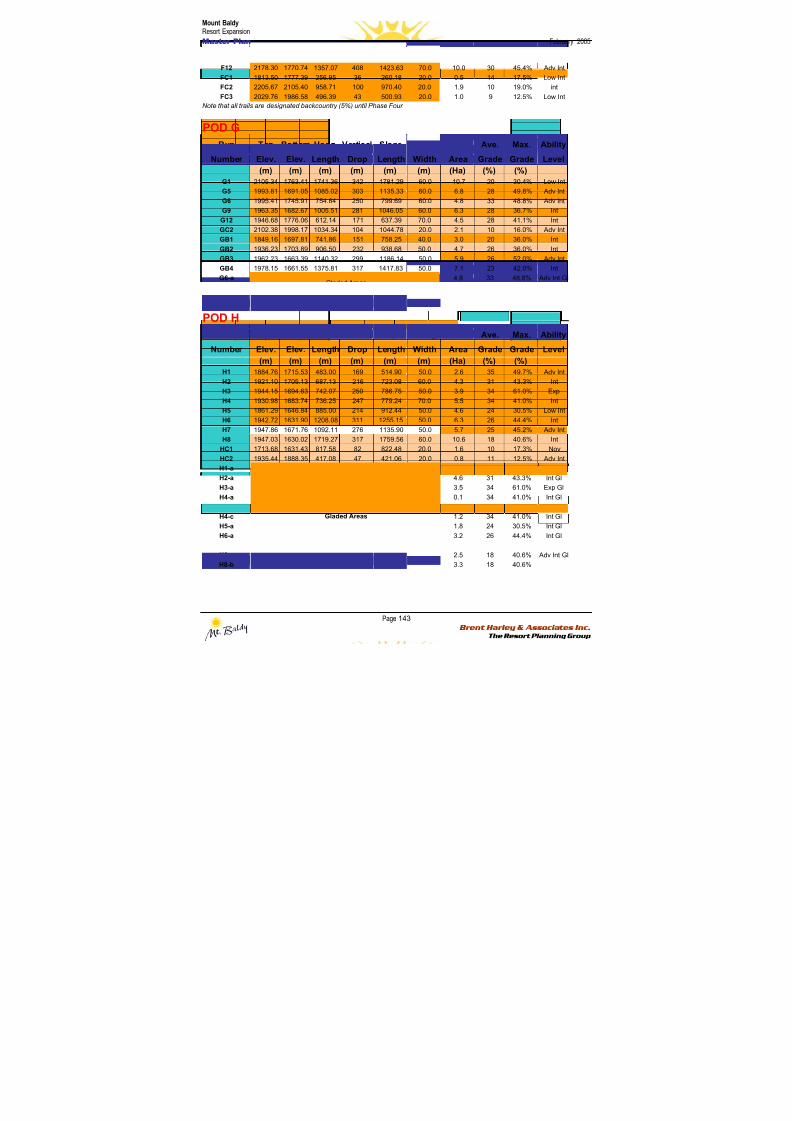
8/12/2019 Mount Baldy
http://slidepdf.com/reader/full/mount-baldy 161/322
Mount BaldyResort Expansion
Master Plan February 2005
Page 143 Brent Harley & Associates Inc.
The Resort Planning Group
F12 2178.30 1770.74 1357.07 408 1423.63 70.0 10.0 30 45.4% Adv Int
FC1 1813.50 1777.39 256.95 36 260.18 20.0 0.5 14 17.5% Low Int
FC2 2205.67 2105.40 958.71 100 970.40 20.0 1.9 10 19.0% int
FC3 2029.76 1986.58 496.39 43 500.93 20.0 1.0 9 12.5% Low Int
Note that all trails are designated backcountry (5%) until Phase Four
POD GRun Top Bottom Horiz. Vertical Slope Average Ave. Max. Ability
Number Elev. Elev. Length Drop Length Width Area Grade Grade Level
(m) (m) (m) (m) (m) (m) (Ha) (%) (%)
G1 2105.34 1763.41 1741.36 342 1781.29 60.0 10.7 20 30.4% Low Int
G5 1993.81 1691.05 1085.02 303 1135.33 60.0 6.8 28 49.8% Adv Int
G6 1995.41 1745.91 754.84 250 799.69 60.0 4.8 33 48.8% Adv Int
G9 1963.35 1682.67 1005.51 281 1046.05 60.0 6.3 28 36.7% Int
G12 1946.68 1776.06 612.14 171 637.39 70.0 4.5 28 41.1% Int
GC2 2102.38 1998.17 1034.34 104 1044.78 20.0 2.1 10 16.0% Adv Int
GB1 1849.16 1697.81 741.86 151 758.25 40.0 3.0 20 36.0% Int
GB2 1936.23 1703.89 906.50 232 938.68 50.0 4.7 26 36.0% Int
GB3 1962.23 1663.39 1140.32 299 1186.14 50.0 5.9 26 52.0% Adv Int
GB4 1978.15 1661.55 1375.81 317 1417.83 50.0 7.1 23 42.0% Int
G6-a 4.8 33 48.8% Adv Int Gl
G6-bGladed Areas
3.8 33 48.8% Adv Int Gl
Note that all trails are designated backcountry (5%) until Phase Four
POD H
Run Top Bottom Horiz. Vertical Slope Average Ave. Max. Ability
Number Elev. Elev. Length Drop Length Width Area Grade Grade Level
(m) (m) (m) (m) (m) (m) (Ha) (%) (%)
H1 1884.76 1715.53 483.00 169 514.90 50.0 2.6 35 49.7% Adv Int
H2 1921.10 1705.13 687.13 216 723.08 60.0 4.3 31 43.3% IntH3 1944.15 1694.63 742.07 250 786.75 50.0 3.9 34 61.0% Exp
H4 1930.98 1683.74 736.25 247 779.24 70.0 5.5 34 41.0% Int
H5 1861.29 1646.84 885.00 214 912.44 50.0 4.6 24 30.5% Low Int
H6 1942.72 1631.90 1208.08 311 1255.15 50.0 6.3 26 44.4% Int
H7 1947.86 1671.76 1092.11 276 1135.90 50.0 5.7 25 45.2% Adv Int
H8 1947.03 1630.02 1719.27 317 1759.56 60.0 10.6 18 40.6% Int
HC1 1713.68 1631.43 817.58 82 822.48 20.0 1.6 10 17.3% Nov
HC2 1935.44 1888.35 417.08 47 421.06 20.0 0.8 11 12.5% Adv Int
H1-a 2.1 35 49.7% Adv Int Gl
H2-a 4.6 31 43.3% Int Gl
H3-a 3.5 34 61.0% Exp Gl
H4-a 0.1 34 41.0% Int Gl
H4-b 4.0 34 41.0% Int GlH4-c 1.2 34 41.0% Int Gl
H5-a 1.8 24 30.5% Int Gl
H6-a 3.2 26 44.4% Int Gl
H7-a 2.8 25 45.2% Adv Int Gl
H8-a 2.5 18 40.6% Adv Int Gl
H8-b
Gladed Areas
3.3 18 40.6% Adv Int Gl
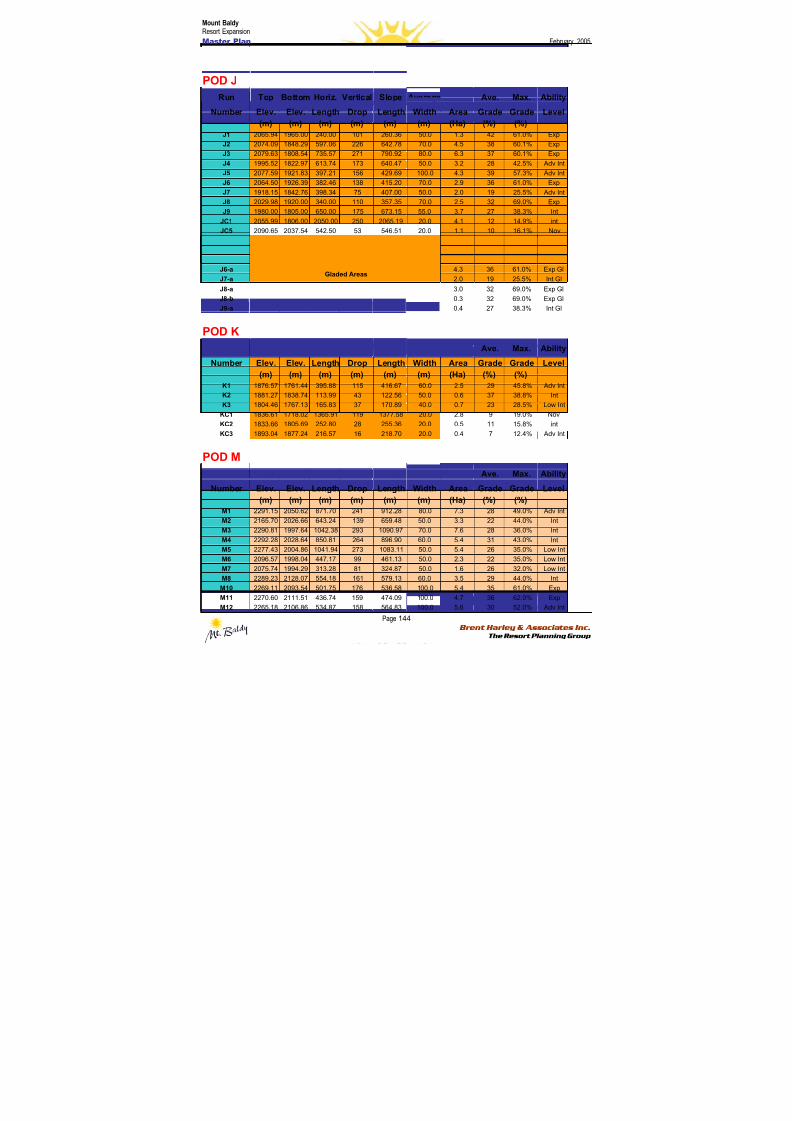
8/12/2019 Mount Baldy
http://slidepdf.com/reader/full/mount-baldy 162/322
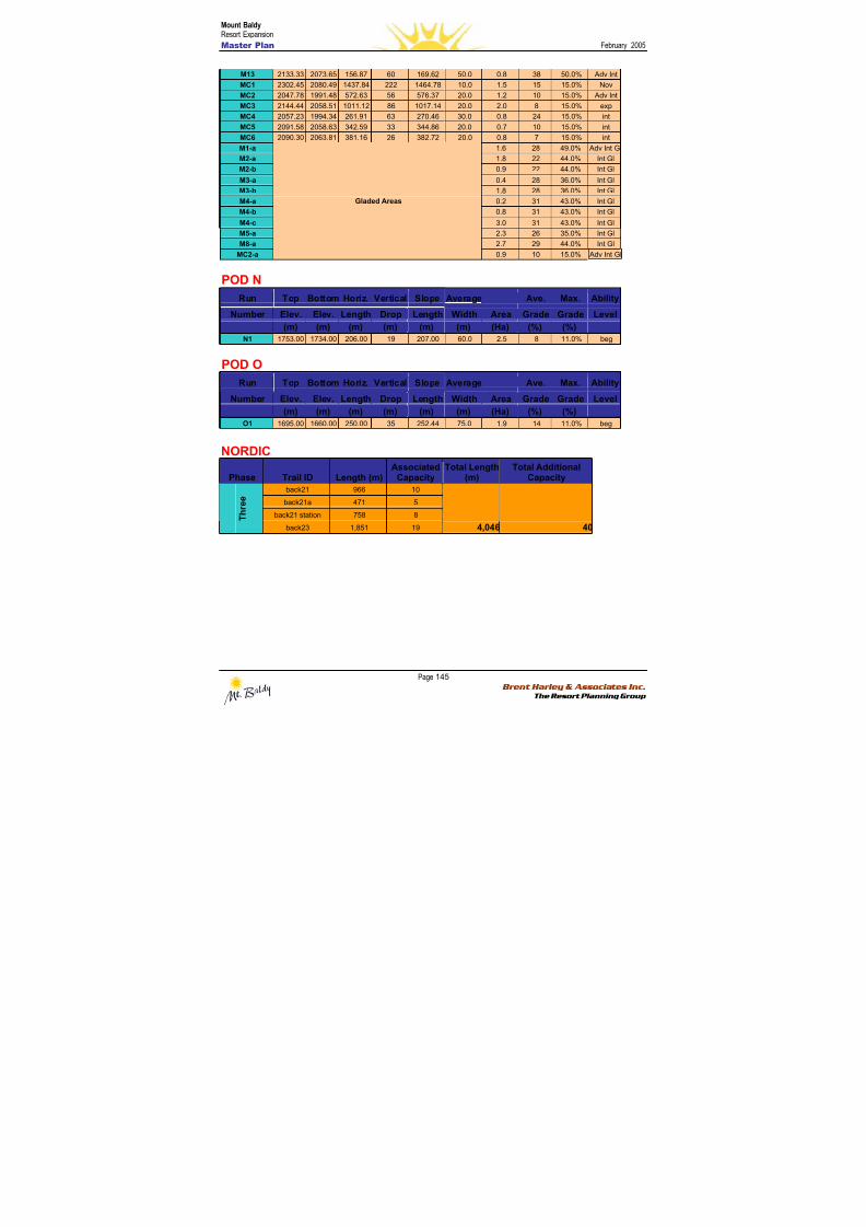
8/12/2019 Mount Baldy
http://slidepdf.com/reader/full/mount-baldy 163/322
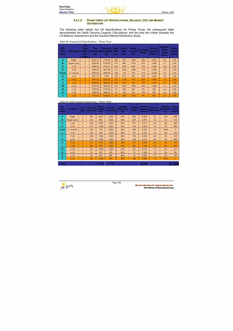
8/12/2019 Mount Baldy
http://slidepdf.com/reader/full/mount-baldy 164/322
Mount BaldyResort Expansion
Master Plan February 2005
Page 146 Brent Harley & Associates Inc.
The Resort Planning Group
55..44..11..22 PPHHAASSEE TTHHRREEEE LLIIFFTT SSPPEECCIIFFIICCAATTIIOONNSS,, BBAALLAANNCCEE,, CCCCCC AANNDD MMAARRKKEETT
DDIISSTTRRIIBBUUTTIIOONN
The following table details the Lift Specifications for Phase Three; the subsequent tabledemonstrates the Uphill Carrying Capacity Calculations; and the final two charts illustrate theLift Balance Assessment and the resultant Market Distribution Study.
Table 44. Proposed Lift Specifications – Phase Three
Table 45. Uphill Capacity Assessment – Phase Three
Lift -Pod
Area
Lift NameLift
TypeVerticalRise (m)
SlopeLength
(m)
HourlyCapacity
LoadingEfficiency
(%)
VTM/Hr(000)
VerticalDemand
(m/day)
Hours ofOperation
AccessReduction
(%)
ActualCCC
(skiers)
A Eagle 4 393 1,461 2,200 95% 865 5,438 7.0 12% 936
B Sugar Lump 3 212 955 1,400 95% 297 4,379 7.0 7% 418
C c Lift 3 543 2,087 1,800 95% 977 6,317 6.5 4% 920
D d Lift 4 217 1,298 2,200 85% 478 2,870 7.0 3% 962
D-ext d - ext Lift 4 220 752 2,200 85% 484 2,870 7.0 100% 0
e e Lift 2 126 575 1,200 95% 151 4,140 7.0 0% 243
F f Lift 3 435 1,505 1,800 95% 783 6,424 6.5 0% 753
G g Lift 3 414 1,994 1,800 95% 746 4,913 6.0 0% 865
H h Lift 3 317 1,181 1,800 95% 571 5,236 6.5 0% 673
J J Lift 2 285 918 1,200 95% 342 7,156 6.5 0% 295
M m Lift 3 301 1,089 1,600 95% 481 5,733 7.0 8% 511N n Lift 1 30 252 500 85% 15 1,000 7.0 0% 89
O o Lift 1 35 252 500 85% 18 1,000 7.0 0% 104
P p Lift 2 90 1,044 550 85% 108 1,000 7.0 100% 0
Totals 11,774 17,150 62,444 5,228
Lift -PodArea
Lift Name
LiftType
(skiersper
chair)
TopElevation
(m)
BottomElevation
(m)
Vert.Rise(m)
Horiz.Dist.(m)
SlopeLength
(m)
AverageGrade
HourlyCapacity(Theor.)
Approx.RideTime(min.)
RopeSpeed(m/s)
A Eagle 4 2122.16 1733.00 389 1337 1392 29% 2,200 9.3 2.50
B Sugar Lump 3 1952.09 1733.00 219 986 1010 22% 1,400 6.7 2.50
C c Lift 3 2288.32 1745.74 543 2015 2087 27% 1,800 13.9 2.50
D d Lift 4 1855.00 1637.58 217 1280 1298 17% 2,200 9.4 2.30
D-ext d - ext Lift 4 2075.00 1855.00 220 719 752 31% 2,200 5.4 2.30
E e Lift 2 1851.16 1725 126 575 540 23% 1,200 3.6 2.50
H h Lift 3 1947.03 1630.02 317 1138 1181 28% 1,800 7.9 2.50
J J Lift 2 2090.65 1806.00 285 873 918 33% 1,200 6.1 2.50
M m Lift 3 2292.28 1991.48 301 1047 1089 29% 1,600 7.3 2.50
N n Lift 1 1753.00 1734.00 19 208 209 9% 500 4.4 0.80
O o Lift 1 1695.00 1660.00 35 250 252 14% 500 5.3 0.80
P p Lift 2 1730.00 1638.00 92 1040 1044 9% 550 5.8 3.00

8/12/2019 Mount Baldy
http://slidepdf.com/reader/full/mount-baldy 165/322
Mount BaldyResort Expansion
Master Plan February 2005
Page 147 Brent Harley & Associates Inc.
The Resort Planning Group
Chart 8. Lift Balance Assessment – Phase Three
Lift Balance Assessment
0
200
400
600
800
1,000
1,200
a b c d D-ext
e f g h j k m n o p
Pod and Lift Areas
# o f S k i e r s
Lift Capacity (CCC)
Alpine Capacity (CCC)
Chart 9. Alpine Terrain Distribution Analysis – Phase Three
Proposed Skier Distribution
0%
5%
10%
15%
20%
25%
30%
35%
40%
45%
Beginner Novice Low Inter. Intermediate Adv. Inter. Expert
Skier Ability Level
% o f S k i e r M a r k e t
Market Standard CASP
BHA Analysis of Distribution
Note: the ‘error bars’ on the above graphic denote the accepted CASP range of distribution in each identified skier ability level.
8/12/2019 Mount Baldy
http://slidepdf.com/reader/full/mount-baldy 166/322
Mount BaldyResort Expansion
Master Plan February 2005
Page 148 Brent Harley & Associates Inc.
The Resort Planning Group
5.4.2 BBaassee A Ar r eeaa DDeev v eel l oo p pmmeennt t P P l l aann – – P P hhaassee T T hhr r eeee
The most prominent change in Phase Three is the introduction of the golf course, the expansionof the Village Core and the development of associated resort residential real estate west of theVillage area. Also substantial is the completion of the realignment of the access road and the
creation a more substantial gateway experience to both enhance the resort’s unique sense ofarrival, and to establish additional high quality infill real estate on the lands between the twobase areas. To balance the additional increase of resort carrying capacity of 1,478 guests/day,this Phase proposes an increase of 620 private bed units, and 780 public bed units.
The Upper Base As the Upper Base has reached buildout, any development activity will be oriented to makingrefinements and upgrades to the existing structures and surrounding landscape.
The VillagePhase Three continues to add development to the Village core, further establishing the area asthe destination guest focal area. Moreover, Phase Three expands to include both the golfcourse facility as well as the associated club house and related service buildings. Additionalskier related service space will be developed to serve the increasing concentration ofdestination guests staying in the Village area. Associated underground parking will continue tobe developed within this phase and the pedestrian orientation of the Village core will beincreasingly established as an amenity in itself. In total, approximately 2,752 square metres ofskier-related and destination guest oriented space will be developed in Phase Three.
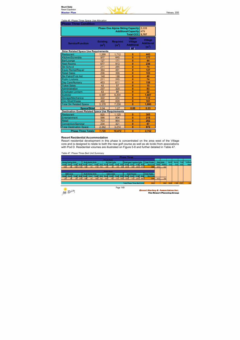
8/12/2019 Mount Baldy
http://slidepdf.com/reader/full/mount-baldy 167/322
Mount BaldyResort Expansion
Master Plan February 2005
Page 149 Brent Harley & Associates Inc.
The Resort Planning Group
Table 46. Phase Three Space Use Allocation
Resort Residential AccommodationResort residential development in this phase is concentrated on the area west of the Villagecore and is designed to relate to both the new golf course as well as ski to/ski from associationswith Pod D. Residential volumes are illustrated on Figure 5-8 and further detailed in Table 47.
Table 47. Phase Three Bed Unit Summary
Single Family Units Multi-family Units RV Park Units Employee Housing Units Total Private Uphill Alpine Total Tot/
Exist Com. Total BUs Exist Com. Total BUs Exist Com. Total BUs Exist Com. Total BUs Bed Units Ratio Added CCC CCC CCC
303 55 358 2148 136 40 176 704 30 0 30 60 220 65 285 570 3482 60% 620
B&B Units Multi-family Units Cabin Units Hotel Rooms Total Public
Exist Com. Total BUs Exist Com. Total BUs Exist Com. Total BUs Exist Com. Total BUs Bed Units
27 10 37 370 158 40 198 792 100 75 175 700 134 110 244 488 2350 40% 780
5832 1400 5228 5196 5707
Bed Units
Private Beds
Phase Three
Public Beds
Total Phase Three Bed Units
5,2284795,707
Service/FunctionExisting
(m2)
Required
(m2)
UpperVillage
Additional
m2
Village
Additional
(m2)
Restaurant 1,269 1,712 0 443Kitchen/Scramble 507 685 0 177Bar/Lounge 127 171 0 44Rest Rooms 677 913 0 236Ski School 211 285 0 74Equip Rental/Repair 364 491 0 127Retail Sales 296 399 0 103
Ski Patrol/First Aid 140 188 0 49Public Lockers 211 285 0 74Day Care/Nursery 453 611 0 158Ticket Sales 42 57 0 15 Administration 237 320 0 83Employee Lockers 63 86 0 22Subtotal 4,597 6,204 0 1,607Storage/Mechanical 322 434 0 112Circ./Wall/Waste 460 620 0 161Total Ski Related Space 5,378 7,258 0 1,880
Space/Skier 0.94 1.27 0.00 0.33
Restaurant 820 1,125 0 305Entertainment 586 804 0 218Retail 703 964 0 262Convention/Seminar 234 321 0 87Total Destination Space 2,342 3,214 0 872
Phase Three Totals 7,720 10,472 0 2,752
Skier Related Space Use Requirements
Destination Guest Related Space Use Requirements
Phase One Alpine Skiing Capacity:Additional Capacity:
Total CCC:
Phase Three Condition
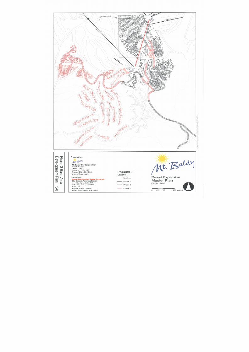
8/12/2019 Mount Baldy
http://slidepdf.com/reader/full/mount-baldy 168/322
8/12/2019 Mount Baldy
http://slidepdf.com/reader/full/mount-baldy 169/322
Mount BaldyResort Expansion
Master Plan February 2005
Page 151 Brent Harley & Associates Inc.
The Resort Planning Group
55..55 PPHHAASSEE FFOOUURR
5.5.1 M M oou u nnt t aai i nn DDeev v eel l oo p pmmeennt t P P l l aann – – P P hhaassee F F oou u r r
The final additions to the mountain plan are dominated by the addition of two fixed grip triple or
quad chairs on the northwestern periphery of the mountain (Pods F and G). Importantly, theaddition of these two chairs involves the conversion of some of the previously designatedbackcountry adventure trails to lift-serviced status. The conversion of these trails will be acutelydependant on changing market trends, future economic constraints, and emerging businessopportunities as these lifts substantially alter the relative balance between backcountry and lift-serviced terrain. The inclusion of these two lifts increases the resort capacity from 5,707 to7,776 skiers/day.
In addition to the increased capacity associated with the development of these two chairs,increases to the length of the Nordic network total more than 20 kilometres, and will result in anassociated capacity increase of over 200 skiers/day. Moreover, the additional Nordic terrainfinalizes a number of creative linkages between the alpine and Nordic networks and thereby
provides substantial opportunity for marketing a truly unique Nordic experience.
In sum, this phase proposes more than 20 km of Nordic trail development, 15 new lift-servicedtrails, additional gladed terrain, and the conversion of 16 backcountry-only trails to lift-servicedstatus (leaving a total of 13 dedicated backcountry adventure trails and associated gladedareas)
Finally, in addition to the lifts associated with the trail development in the F and G Pods, anadditional residential access lift is proposed to service the base area development described inSection 5.2.4.
For reference, Figure 5-9 illustrates the proposed Phase Four mountain expansion plans.
Specific details of the expanded trail and lift plans are included in the following two sections,while the associated Phase Four base area details are included in Section 5.5.2.
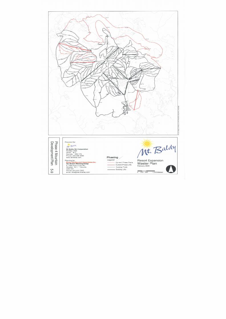
8/12/2019 Mount Baldy
http://slidepdf.com/reader/full/mount-baldy 170/322
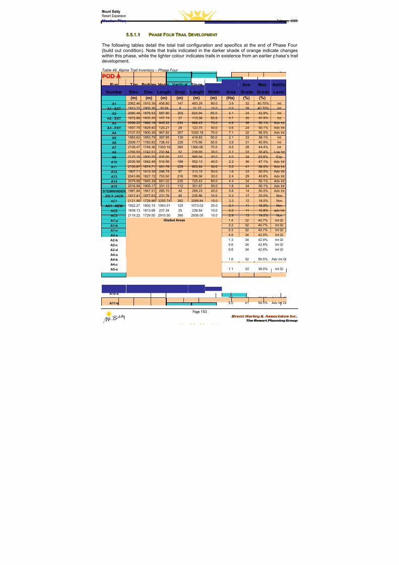
8/12/2019 Mount Baldy
http://slidepdf.com/reader/full/mount-baldy 171/322
Mount BaldyResort Expansion
Master Plan February 2005
Page 153 Brent Harley & Associates Inc.
The Resort Planning Group
55..55..11..11 PPHHAASSEE FFOOUURR TTRRAAIILL DDEEVVEELLOOPPMMEENNTT
The following tables detail the total trail configuration and specifics at the end of Phase Four(build out condition). Note that trails indicated in the darker shade of orange indicate changeswithin this phase, while the lighter colour indicates trails in existence from an earlier phase’s traildevelopment.
Table 48. Alpine Trail Inventory – Phase Four
POD A
Run Top Bottom Horiz. Vertical Slope Average Ave. Max. Ability
Number Elev. Elev. Length Drop Length Width Area Grade Grade Level
(m) (m) (m) (m) (m) (m) (Ha) (%) (%)
A1 2062.46 1915.39 458.80 147 483.29 80.0 3.9 32 40.70% Int
A1 - EXT 1913.72 1905.36 30.06 8 31.27 10.0 0.0 28 40.70% Int
A2 2080.48 1878.53 587.90 202 624.94 65.0 4.1 34 42.9% Int
A2 - EXT 1872.66 1835.30 107.19 37 113.58 65.0 0.7 35 42.9% Int
A3 2096.22 1862.16 645.32 234 688.45 70.0 4.8 36 50.1% Adv Int
A3 - EXT 1857.78 1829.40 120.21 28 123.75 50.0 0.6 24 50.1% Adv IntA4 2107.53 1800.38 967.82 307 1020.18 70.0 7.1 32 56.5% Adv Int
A5 1983.62 1853.79 397.95 130 419.83 50.0 2.1 33 38.1% Int
A6 2009.77 1783.83 738.43 226 775.66 50.0 3.9 31 40.9% Int
A7 2109.47 1749.36 1303.16 360 1360.06 70.0 9.5 28 44.4% Int
A8 1793.93 1742.01 232.84 52 239.69 30.0 0.7 22 30.4% Low Int
A9 2122.16 1800.00 935.00 322 988.94 40.0 4.0 34 63.6% Exp
A10 2030.58 1842.48 516.56 188 552.13 40.0 2.2 36 47.1% Adv Int
A11 2103.67 1874.71 551.76 229 603.84 50.0 3.0 41 58.5% Adv Int
A12 1907.71 1810.39 296.78 97 313.15 50.0 1.6 33 50.5% Adv Int
A13 2043.86 1827.72 753.50 216 789.56 30.0 2.4 29 45.6% Adv Int
A14 2079.98 1845.39 681.02 235 725.43 60.0 4.4 34 50.1% Adv Int
A15 2016.94 1905.17 331.12 112 351.67 50.0 1.8 34 50.1% Adv Int
STEMWINDER 1987.84 1947.51 285.70 40 289.23 20.0 0.6 14 50.0% Adv IntJOLY JACK 1917.41 1877.63 231.76 40 235.86 10.0 0.2 17 25.0% Nov
AC1 2121.98 1729.96 3255.74 392 3289.84 10.0 3.3 12 18.0% Nov
AC1 - NEW 1922.27 1802.19 1063.01 120 1073.02 20.0 2.1 11 15.0% Nov
AC2 1839.13 1813.68 237.34 25 238.84 10.0 0.2 11 10.8% adv Int
AC3 2119.22 1729.00 2910.00 390 2936.05 10.0 2.9 13 14.0% Nov
A1-a 1.4 32 40.7% Int Gl
A1-b 3.3 32 40.7% Int Gl
A1-c 0.3 32 40.7% Int Gl
A2-a 4.8 34 42.9% Int Gl
A2-b 1.3 34 42.9% Int Gl
A2-c 0.6 34 42.9% Int Gl
A2-d 0.6 34 42.9% Int Gl
A4-a 0.7 32 56.5% Adv Int GlA4-b 1.6 32 56.5% Adv Int Gl
A4-c 3.4 32 56.5% Adv Int Gl
A5-a 1.1 33 38.0% Int Gl
A7-a 1.1 28 44.0% Int Gl
A9-a 2.7 34 63.0% Exp Gl
A9-b 2.3 34 63.0% Exp Gl
A9-c 1.4 34 63.0% Exp Gl
A10-a 1.2 36 47.0% Adv Int Gl
A11-a 0.1 41 58.5% Adv Int Gl
A11-b
Gladed Areas
5.0 41 58.5% Adv Int Gl
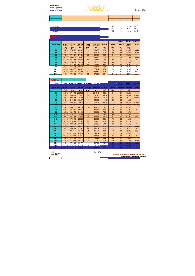
8/12/2019 Mount Baldy
http://slidepdf.com/reader/full/mount-baldy 172/322
Mount BaldyResort Expansion
Master Plan February 2005
Page 154 Brent Harley & Associates Inc.
The Resort Planning Group
A13-a 3.2 29 45.6% Adv Int Gl
A14-a 6.2 34 50.1% Adv Int Gl
A15-a 2.4 34 50.1% Adv Int Gl
A15-b 2.4 34 50.0% Adv Int Gl
AC1-a 0.5 12 18.0% Int Gl
AC1-b 4.1 12 18.0% Int Gl
AC3-a 0.8 13 14.0% Int Gl
POD B
Run Top Bottom Horiz. Vertical Slope Average Ave. Max. Ability
Number Elev. Elev. Length Drop Length Width Area Grade Grade Level
(m) (m) (m) (m) (m) (m) (Ha) (%) (%)
B1 1887.96 1756.15 682.97 132 700.57 40.0 2.8 19 31.0% Low Int
B2 1897.22 1774.42 487.23 123 503.05 40.0 2.0 25 28.5% Low Int
B3 1879.29 1796.27 271.23 83 284.10 50.0 1.4 31 36.5% Int
B4 1908.89 1850.62 288.67 58 295.27 30.0 0.9 20 25.8% Low Int
B5 1952.09 1751.11 797.27 201 828.18 50.0 4.1 25 37.5% Int
B6 1957.02 1753.04 761.19 204 792.52 50.0 4.0 27 41.3% IntB7 1952.87 1748.36 951.62 205 978.89 35.0 3.4 21 35.9% Int
B8 1860.04 1746.51 493.13 114 509.51 50.0 2.5 23 36.8% Int
BC1 1950.82 1843.57 864.47 107 875.94 10.0 0.9 12 15.0% Nov
BC2 1890.94 1851.95 413.20 39 419.80 10.0 0.4 9 15.0% Nov
BC3 1747.10 1733.00 172.00 14 173.00 30.0 0.4 6 8.0% beg
POD C
Run Top Bottom Horiz. Vertical Slope Average Ave. Max. Ability
Number Elev. Elev. Length Drop Length Width Area Grade Grade Level
(m) (m) (m) (m) (m) (m) (Ha) (%) (%)
C1 2288.32 1745.74 2637.85 543 2716.17 30.0 8.1 21 39.5% IntC2 2289.67 1895.47 1308.01 394 1382.63 100.0 13.8 30 54.6% Adv Int
C3 2258.27 2026.83 732.50 231 773.98 100.0 7.7 32 45.1% Adv Int
C4 2249.51 2102.08 422.67 147 450.14 100.0 4.5 35 44.0% Int
C5 2284.03 1867.16 1279.24 417 1354.38 100.0 13.5 33 49.4% Adv Int
C6 2193.70 1919.87 788.30 274 838.53 70.0 5.9 35 49.4% Adv Int
C7 2027.92 1867.89 452.28 160 480.85 70.0 3.4 35 41.4% Int
C8 1986.03 1842.72 399.46 143 425.79 60.0 2.6 36 43.9% Int
C9 1958.42 1817.31 540.48 141 562.20 70.0 3.9 26 44.7% Int
C10 1949.05 1752.22 744.33 197 771.95 60.0 4.6 26 37.8% Int
C11 2166.81 1861.51 749.88 305 818.17 100.0 8.2 41 61.0% Exp
C12 2134.92 1750.41 1205.93 385 1273.96 60.0 7.6 32 44.9% Int
C13 2105.78 1766.12 1000.85 340 1059.53 70.0 7.4 34 41.7% Int
C14 2052.13 1888.24 639.96 164 664.85 50.0 3.3 26 37.4% Int
CC1 1993.80 1950.69 453.71 43 456.92 20.0 0.9 10 12.8% Low Int
CC2 1863.72 1808.67 671.26 55 676.04 40.0 2.7 8 20.6% int
CC4 2263.14 2242.36 161.63 21 165.27 10.0 0.2 13 12.0% beg
CB1 1928.10 1776.21 628.19 152 649.64 50.0 3.2 24 37.0% Int
CB2 1900.18 1759.57 610.67 141 629.22 50.0 3.1 23 37.0% Int
CB3 1899.69 1711.89 702.77 188 728.24 40.0 2.9 27 37.0% Int
CB4 1918.25 1719.24 1090.77 199 1113.43 50.0 5.6 18 32.0% Low Int
CB5 1846.51 1718.08 551.77 128 567.93 40.0 2.3 23 28.0% Low Int
CB6 1898.84 1742.07 511.75 157 537.09 70.0 3.8 31 42.0% Int
CB7 1896.79 1744.04 465.98 153 492.80 70.0 3.4 33 44.0% Int
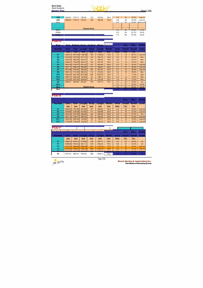
8/12/2019 Mount Baldy
http://slidepdf.com/reader/full/mount-baldy 173/322
Mount BaldyResort Expansion
Master Plan February 2005
Page 155 Brent Harley & Associates Inc.
The Resort Planning Group
CB8 1946.57 1774.17 796.46 172 816.40 60.0 4.9 22 35.0% Low Int
CB9 1906.63 1778.14 570.53 128 585.92 50.0 2.9 23 33.0% Low Int
C2-a 0.8 30 54.6% Adv Int Gl
C2-b 0.9 30 54.6% Adv Int Gl
C2-c 1.3 30 54.6% Adv Int Gl
C12-a 1.2 32 45.0% Int Gl
C13-a 2.4 34 41.7% Int GlC14-a
Gladed Areas
1.9 26 37.4% Int Gl
POD D
Run Top Bottom Horiz. Vertical Slope Average Ave. Max. Ability
Number Elev. Elev. Length Drop Length Width Area Grade Grade Level
(m) (m) (m) (m) (m) (m) (Ha) (%) (%)
D1 1832.91 1637.58 1108.99 195 1128.62 70.0 7.9 18 25.1% Low Int
D2 1818.60 1675.00 817.73 144 834.19 40.0 3.3 18 24.2% Nov
D3 1823.69 1683.05 842.44 141 855.28 45.0 3.8 17 22.7% Nov
D4 1828.87 1726.69 642.43 102 651.62 50.0 3.3 16 24.3% Nov
D5 1842.58 1705.31 837.55 137 852.40 65.0 5.5 16 24.3% Low IntD6 1957.17 1840.14 440.89 117 456.61 60.0 2.7 27 35.0% Low Int
D7 1812.06 1743.81 525.08 68 531.67 50.0 2.7 13 30.0% Low Int
D8 1845.10 1731.83 692.93 113 703.29 50.0 3.5 16 25.0% Nov
D10 1842.00 1637.00 3010.00 205 3016.97 25.0 7.5 7 11.0% beg
DC2 1855.31 1832.42 193.89 23 196.12 20.0 0.4 12 16.4% Nov
DC3 1724.29 1637.52 909.06 87 915.28 20.0 1.8 10 13.5% Nov
D9 1983.47 1829.86 653.65 154 675.10 70.0 4.7 24 42.0% Int
D6-a 1.5 27 35.0% Int Gl
D9-a 1.6 24 42.0% Int Gl
D9-b
Gladed Areas
2.0 24 42.0% Int Gl
POD E
Run Top Bottom Horiz. Vertical Slope Average Ave. Max. Ability
Number Elev. Elev. Length Drop Length Width Area Grade Grade Level
(m) (m) (m) (m) (m) (m) (Ha) (%) (%)
E1 1850.63 1753.56 437.68 97 449.22 50.0 2.2 22 30.2% Low Int
E2 1839.68 1728.28 614.60 111 630.86 50.0 3.2 18 31.5% Low Int
E3 1816.24 1721.97 389.26 94 403.02 50.0 2.0 24 37.7% Int
E4 1851.16 1729.77 548.35 121 564.64 50.0 2.8 22 27.2% Low Int
EC1 1852.50 1833.45 140.89 19 142.77 20.0 0.3 14 15.2% Low Int
EC2 1753.68 1736.43 152.05 17 154.12 40.0 0.6 11 12.2% Low Int
POD F
Run Top Bottom Horiz. Vertical Slope Average Ave. Max. Ability
Number Elev. Elev. Length Drop Length Width Area Grade Grade Level
(m) (m) (m) (m) (m) (m) (Ha) (%) (%)
F1 1955.51 1816.41 515.86 139 535.17 60.0 3.2 27 36.2% Int
F2 1988.66 1769.43 801.11 219 834.24 70.0 5.8 27 43.3% Int
F3 2175.54 1828.48 1060.59 347 1123.32 70.0 7.9 33 45.4% Adv Int
F4 2193.62 1788.01 1362.23 406 1430.75 60.0 8.6 30 47.4% Adv Int
F5 2171.07 1979.77 670.38 191 702.35 60.0 4.2 29 46.7% Adv Int
F6 2161.91 1853.14 1164.53 309 1209.11 45.0 5.4 27 38.4% Int
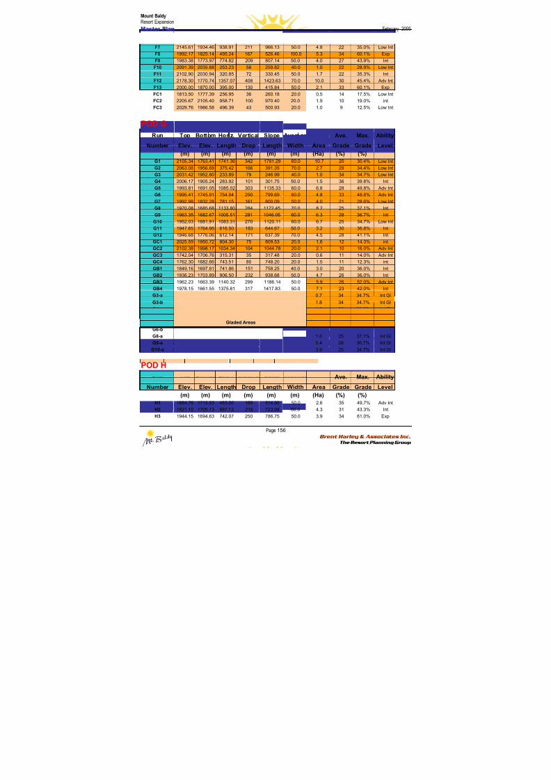
8/12/2019 Mount Baldy
http://slidepdf.com/reader/full/mount-baldy 174/322
Mount BaldyResort Expansion
Master Plan February 2005
Page 156 Brent Harley & Associates Inc.
The Resort Planning Group
F7 2145.61 1934.46 938.91 211 966.13 50.0 4.8 22 35.0% Low Int
F8 1992.17 1825.14 495.24 167 526.46 100.0 5.3 34 60.1% Exp
F9 1983.38 1773.97 774.82 209 807.14 50.0 4.0 27 43.9% Int
F10 2091.39 2035.88 253.23 56 259.82 40.0 1.0 22 28.9% Low Int
F11 2102.90 2030.94 320.85 72 330.45 50.0 1.7 22 35.3% Int
F12 2178.30 1770.74 1357.07 408 1423.63 70.0 10.0 30 45.4% Adv Int
F13 2000.00 1870.00 395.00 130 415.84 50.0 2.1 33 60.1% ExpFC1 1813.50 1777.39 256.95 36 260.18 20.0 0.5 14 17.5% Low Int
FC2 2205.67 2105.40 958.71 100 970.40 20.0 1.9 10 19.0% int
FC3 2029.76 1986.58 496.39 43 500.93 20.0 1.0 9 12.5% Low Int
POD G
Run Top Bottom Horiz. Vertical Slope Average Ave. Max. Ability
Number Elev. Elev. Length Drop Length Width Area Grade Grade Level
(m) (m) (m) (m) (m) (m) (Ha) (%) (%)
G1 2105.34 1763.41 1741.36 342 1781.29 60.0 10.7 20 30.4% Low Int
G2 2063.08 1956.69 375.42 106 391.35 70.0 2.7 28 34.4% Low Int
G3 2031.42 1952.80 233.89 79 246.99 40.0 1.0 34 34.7% Low IntG4 2006.17 1905.24 283.92 101 301.75 50.0 1.5 36 39.8% Int
G5 1993.81 1691.05 1085.02 303 1135.33 60.0 6.8 28 49.8% Adv Int
G6 1995.41 1745.91 754.84 250 799.69 60.0 4.8 33 48.8% Adv Int
G7 1992.98 1832.28 781.15 161 800.09 50.0 4.0 21 28.6% Low Int
G8 1970.08 1685.68 1133.80 284 1172.45 70.0 8.2 25 37.1% Int
G9 1963.35 1682.67 1005.51 281 1046.05 60.0 6.3 28 36.7% Int
G10 1952.03 1681.91 1083.31 270 1120.11 60.0 6.7 25 34.7% Low Int
G11 1947.65 1764.66 616.50 183 644.67 50.0 3.2 30 36.8% Int
G12 1946.68 1776.06 612.14 171 637.39 70.0 4.5 28 41.1% Int
GC1 2025.59 1950.72 804.30 75 809.53 20.0 1.6 12 14.3% int
GC2 2102.38 1998.17 1034.34 104 1044.78 20.0 2.1 10 16.0% Adv Int
GC3 1742.04 1706.76 315.31 35 317.48 20.0 0.6 11 14.0% Adv Int
GC4 1762.30 1682.66 743.51 80 748.20 20.0 1.5 11 12.3% int
GB1 1849.16 1697.81 741.86 151 758.25 40.0 3.0 20 36.0% Int
GB2 1936.23 1703.89 906.50 232 938.68 50.0 4.7 26 36.0% Int
GB3 1962.23 1663.39 1140.32 299 1186.14 50.0 5.9 26 52.0% Adv Int
GB4 1978.15 1661.55 1375.81 317 1417.83 50.0 7.1 23 42.0% Int
G3-a 0.7 34 34.7% Int Gl
G3-b 1.8 34 34.7% Int Gl
G4-a 1.0 36 39.8% Int Gl
G5-a 6.9 28 49.8% Adv Int Gl
G6-a 4.8 33 48.8% Adv Int Gl
G6-b 3.8 33 48.8% Adv Int Gl
G8-a 1.6 25 37.1% Int Gl
G9-a 5.4 28 36.7% Int Gl
G10-a
Gladed Areas
3.9 25 34.7% Int Gl
POD H
Run Top Bottom Horiz. Vertical Slope Average Ave. Max. Ability
Number Elev. Elev. Length Drop Length Width Area Grade Grade Level
(m) (m) (m) (m) (m) (m) (Ha) (%) (%)
H1 1884.76 1715.53 483.00 169 514.90 50.0 2.6 35 49.7% Adv Int
H2 1921.10 1705.13 687.13 216 723.08 60.0 4.3 31 43.3% Int
H3 1944.15 1694.63 742.07 250 786.75 50.0 3.9 34 61.0% Exp
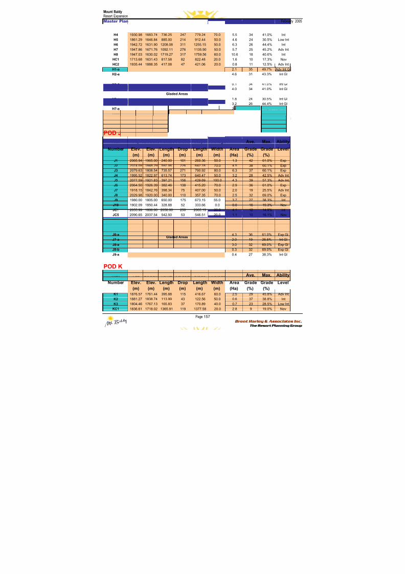
8/12/2019 Mount Baldy
http://slidepdf.com/reader/full/mount-baldy 175/322
Mount BaldyResort Expansion
Master Plan February 2005
Page 157 Brent Harley & Associates Inc.
The Resort Planning Group
H4 1930.98 1683.74 736.25 247 779.24 70.0 5.5 34 41.0% Int
H5 1861.29 1646.84 885.00 214 912.44 50.0 4.6 24 30.5% Low Int
H6 1942.72 1631.90 1208.08 311 1255.15 50.0 6.3 26 44.4% Int
H7 1947.86 1671.76 1092.11 276 1135.90 50.0 5.7 25 45.2% Adv Int
H8 1947.03 1630.02 1719.27 317 1759.56 60.0 10.6 18 40.6% Int
HC1 1713.68 1631.43 817.58 82 822.48 20.0 1.6 10 17.3% Nov
HC2 1935.44 1888.35 417.08 47 421.06 20.0 0.8 11 12.5% Adv IntH1-a 2.1 35 49.7% Adv Int Gl
H2-a 4.6 31 43.3% Int Gl
H3-a 3.5 34 61.0% Exp Gl
H4-a 0.1 34 41.0% Int Gl
H4-b 4.0 34 41.0% Int Gl
H4-c 1.2 34 41.0% Int Gl
H5-a 1.8 24 30.5% Int Gl
H6-a 3.2 26 44.4% Int Gl
H7-a 2.8 25 45.2% Adv Int Gl
H8-a 2.5 18 40.6% Adv Int Gl
H8-b
Gladed Areas
3.3 18 40.6% Adv Int Gl
Note: There is no “i” Pod – this is a simple mapping convenience to avoid misinterpreting the letter “i”’ with the number one.
POD J
Run Top Bottom Horiz. Vertical Slope Average Ave. Max. Ability
Number Elev. Elev. Length Drop Length Width Area Grade Grade Level
(m) (m) (m) (m) (m) (m) (Ha) (%) (%)
J1 2065.94 1965.00 240.00 101 260.36 50.0 1.3 42 61.0% Exp
J2 2074.09 1848.29 597.06 226 642.78 70.0 4.5 38 60.1% Exp
J3 2079.63 1808.54 735.57 271 790.92 80.0 6.3 37 60.1% Exp
J4 1995.52 1822.97 613.74 173 640.47 50.0 3.2 28 42.5% Adv Int
J5 2077.59 1921.83 397.21 156 429.69 100.0 4.3 39 57.3% Adv Int
J6 2064.50 1926.39 382.46 138 415.20 70.0 2.9 36 61.0% Exp
J7 1918.15 1842.76 398.34 75 407.00 50.0 2.0 19 25.5% Adv Int
J8 2029.98 1920.00 340.00 110 357.35 70.0 2.5 32 69.0% ExpJ9 1980.00 1805.00 650.00 175 673.15 55.0 3.7 27 38.3% Int
J10 1902.09 1850.44 328.88 52 333.66 0.0 0.0 16 19.3% Nov
JC1 2055.99 1806.00 2050.00 250 2065.19 20.0 4.1 12 14.9% int
JC5 2090.65 2037.54 542.50 53 546.51 20.0 1.1 10 16.1% Nov
J2-a 2.8 38 60.1% Exp Gl
J4-a 4.8 28 42.5% Int Gl
J5-a 3.1 39 57.3% Adv Int Gl
J6-a 4.3 36 61.0% Exp Gl
J7-a 2.0 19 25.5% Int Gl
J8-a 3.0 32 69.0% Exp Gl
J8-b 0.3 32 69.0% Exp Gl
J9-a
Gladed Areas
0.4 27 38.3% Int Gl
POD K
Run Top Bottom Horiz. Vertical Slope Average Ave. Max. Ability
Number Elev. Elev. Length Drop Length Width Area Grade Grade Level
(m) (m) (m) (m) (m) (m) (Ha) (%) (%)
K1 1876.57 1761.44 395.88 115 416.67 60.0 2.5 29 45.8% Adv Int
K2 1881.27 1838.74 113.99 43 122.56 50.0 0.6 37 38.8% Int
K3 1804.46 1767.13 165.83 37 170.89 40.0 0.7 23 28.5% Low Int
KC1 1836.61 1718.02 1365.91 119 1377.58 20.0 2.8 9 19.0% Nov
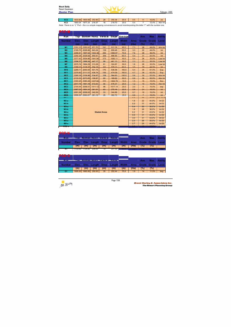
8/12/2019 Mount Baldy
http://slidepdf.com/reader/full/mount-baldy 176/322
Mount BaldyResort Expansion
Master Plan February 2005
Page 158 Brent Harley & Associates Inc.
The Resort Planning Group
KC2 1833.66 1805.69 252.80 28 255.36 20.0 0.5 11 15.8% int
KC3 1893.04 1877.24 216.57 16 218.70 20.0 0.4 7 12.4% Adv Int
Note: There is no “L” Pod – this is a simple mapping convenience to avoid misinterpreting the letter “l”’ with the number one.
POD M
Run Top Bottom Horiz. Vertical Slope Average Ave. Max. AbilityNumber Elev. Elev. Length Drop Length Width Area Grade Grade Level
(m) (m) (m) (m) (m) (m) (Ha) (%) (%)
M1 2291.15 2050.62 871.70 241 912.28 80.0 7.3 28 49.0% Adv Int
M2 2165.70 2026.66 643.24 139 659.48 50.0 3.3 22 44.0% Int
M3 2290.81 1997.64 1042.38 293 1090.97 70.0 7.6 28 36.0% Int
M4 2292.28 2028.64 850.81 264 896.90 60.0 5.4 31 43.0% Int
M5 2277.43 2004.86 1041.94 273 1083.11 50.0 5.4 26 35.0% Low Int
M6 2096.57 1998.04 447.17 99 461.13 50.0 2.3 22 35.0% Low Int
M7 2075.74 1994.29 313.28 81 324.87 50.0 1.6 26 32.0% Low Int
M8 2289.23 2128.07 554.18 161 579.13 60.0 3.5 29 44.0% Int
M10 2269.11 2093.54 501.75 176 536.58 100.0 5.4 35 61.0% Exp
M11 2270.60 2111.51 436.74 159 474.09 100.0 4.7 36 62.0% Exp
M12 2265.18 2106.86 534.87 158 564.83 100.0 5.6 30 52.0% Adv Int
M13 2133.33 2073.65 156.87 60 169.62 50.0 0.8 38 50.0% Adv Int
MC1 2302.45 2080.49 1437.84 222 1464.78 10.0 1.5 15 15.0% Nov
MC2 2047.78 1991.48 572.63 56 576.37 20.0 1.2 10 15.0% Adv Int
MC3 2144.44 2058.51 1011.12 86 1017.14 20.0 2.0 8 15.0% exp
MC4 2057.23 1994.34 261.91 63 270.46 30.0 0.8 24 15.0% int
MC5 2091.58 2058.63 342.59 33 344.86 20.0 0.7 10 15.0% int
MC6 2090.30 2063.81 381.16 26 382.72 20.0 0.8 7 15.0% int
M1-a 1.6 28 49.0% Adv Int Gl
M2-a 1.8 22 44.0% Int Gl
M2-b 0.9 22 44.0% Int Gl
M3-a 0.4 28 36.0% Int Gl
M3-b 1.8 28 36.0% Int Gl
M4-a 0.2 31 43.0% Int Gl
M4-b 0.8 31 43.0% Int Gl
M4-c 3.0 31 43.0% Int Gl
M5-a 2.3 26 35.0% Int Gl
M8-a 2.7 29 44.0% Int Gl
MC2-a
Gladed Areas
0.9 10 15.0% Adv Int Gl
POD N
Run Top Bottom Horiz. Vertical Slope Average Ave. Max. Ability
Number Elev. Elev. Length Drop Length Width Area Grade Grade Level
(m) (m) (m) (m) (m) (m) (Ha) (%) (%)
N1 1753.00 1734.00 206.00 19 207.00 60.0 2.5 8 11.0% beg
POD O
Run Top Bottom Horiz. Vertical Slope Average Ave. Max. Ability
Number Elev. Elev. Length Drop Length Width Area Grade Grade Level
(m) (m) (m) (m) (m) (m) (Ha) (%) (%)
O1 1695.00 1660.00 250.00 35 252.44 75.0 1.9 14 11.0% beg
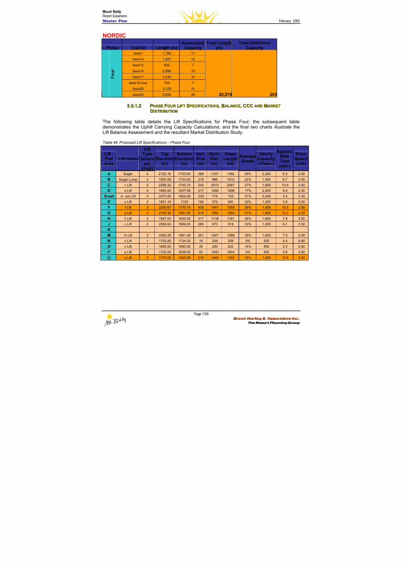
8/12/2019 Mount Baldy
http://slidepdf.com/reader/full/mount-baldy 177/322
Mount BaldyResort Expansion
Master Plan February 2005
Page 159 Brent Harley & Associates Inc.
The Resort Planning Group
NORDIC
Phase Trail ID Length (m)Associated
CapacityTotal Length
(m)Total Additional
Capacity
back1 1,706 17
back14 1,207 12
back15 662 7
back16 6,998 70
back17 3,234 32
back18 loop 704 7
back20 3,129 31
F o u r
back22 2,634 26 20,274 203
55..55..11..22 PPHHAASSEE FFOOUURR LLIIFFTT SSPPEECCIIFFIICCAATTIIOONNSS,, BBAALLAANNCCEE,, CCCCCC AANNDD MMAARRKKEETT
DDIISSTTRRIIBBUUTTIIOONN
The following table details the Lift Specifications for Phase Four; the subsequent table
demonstrates the Uphill Carrying Capacity Calculations; and the final two charts illustrate theLift Balance Assessment and the resultant Market Distribution Study.
Table 49. Proposed Lift Specifications – Phase Four
Lift -PodArea
Lift Name
LiftType
(skiersper
chair)
TopElevation
(m)
BottomElevation
(m)
Vert.Rise(m)
Horiz.Dist.(m)
SlopeLength
(m)
AverageGrade
HourlyCapacity(Theor.)
Approx.RideTime(min.)
RopeSpeed(m/s)
A Eagle 4 2122.16 1733.00 389 1337 1392 29% 2,200 9.3 2.50
B Sugar Lump 3 1952.09 1733.00 219 986 1010 22% 1,400 6.7 2.50
C c Lift 3 2288.32 1745.74 543 2015 2087 27% 1,800 13.9 2.50
D d Lift 4 1855.00 1637.58 217 1280 1298 17% 2,200 9.4 2.30
D-ext d - ext Lift 4 2075.00 1855.00 220 719 752 31% 2,200 5.4 2.30
E e Lift 2 1851.16 1725 126 575 540 23% 1,200 3.6 2.50
F f Lift 3 2205.67 1770.74 435 1441 1505 30% 1,800 10.0 2.50
G g Lift 3 2105.34 1691.05 414 1950 1994 21% 1,800 13.3 2.50
H h Lift 3 1947.03 1630.02 317 1138 1181 28% 1,800 7.9 2.50
J J Lift 2 2090.65 1806.00 285 873 918 33% 1,200 6.1 2.50
K
M m Lift 3 2292.28 1991.48 301 1047 1089 29% 1,600 7.3 2.50
N n Lift 1 1753.00 1734.00 19 208 209 9% 500 4.4 0.80
O o Lift 1 1695.00 1660.00 35 250 252 14% 500 5.3 0.80
P p Lift 2 1730.00 1638.00 92 1040 1044 9% 550 5.8 3.00
Q q Lift 2 1775.00 1565.00 210 1440 1455 15% 1,200 10.5 2.30
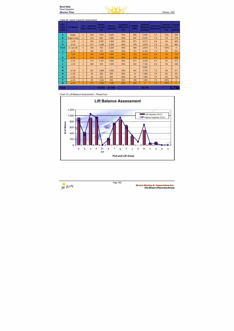
8/12/2019 Mount Baldy
http://slidepdf.com/reader/full/mount-baldy 178/322
Mount BaldyResort Expansion
Master Plan February 2005
Page 160 Brent Harley & Associates Inc.
The Resort Planning Group
Table 50. Uphill Capacity Assessment
Lift -PodArea
Lift NameLift
TypeVerticalRise (m)
SlopeLength
(m)
HourlyCapacity
LoadingEfficiency
(%)
VTM/Hr(000)
VerticalDemand(m/day)
Hours ofOperation
AccessReduction
(%)
ActualCCC
(skiers)
A Eagle 4 393 1,461 2,200 95% 865 5,438 7.0 12% 936
B Sugar Lump 3 212 955 1,400 95% 297 4,379 7.0 7% 418
C c Lift 3 543 2,087 1,800 95% 977 6,317 6.5 4% 920
D d Lift 4 217 1,298 2,200 85% 478 2,870 7.0 3% 962
D-ext d - ext Lift 4 220 752 2,200 85% 484 2,870 7.0 100% 0
e e Lift 2 126 575 1,200 95% 151 4,140 7.0 0% 243
F f Lift 3 435 1,505 1,800 95% 783 6,424 6.5 0% 753
G g Lift 3 414 1,994 1,800 95% 746 4,913 6.0 0% 865
H h Lift 3 317 1,181 1,800 95% 571 5,236 6.5 0% 673
J J Lift 2 285 918 1,200 95% 342 7,156 6.5 0% 295
K - - - - - - - 4,342 - - -
M m Lift 3 301 1,089 1,600 95% 481 5,733 7.0 8% 511
N n Lift 1 30 252 500 85% 15 1,000 7.0 0% 89
O o Lift 1 35 252 500 85% 18 1,000 7.0 0% 104
P p Lift 2 90 1,044 550 85% 108 1,000 7.0 100% 0
Q q Lift 2 210 1,455 1,200 85% 252 0 7.0 100% 0
Totals 16,728 21,950 62,778 6,744 Chart 10. Lift Balance Assessment – Phase Four
Lift Balance Assessment
0
200
400
600
800
1,000
1,200
a b c d D-ext e f g h j k m n o p q
Pod and Lift Areas
# o f S k i e r s
Lift Capacity (CCC)
Alpine Capacity (CCC)
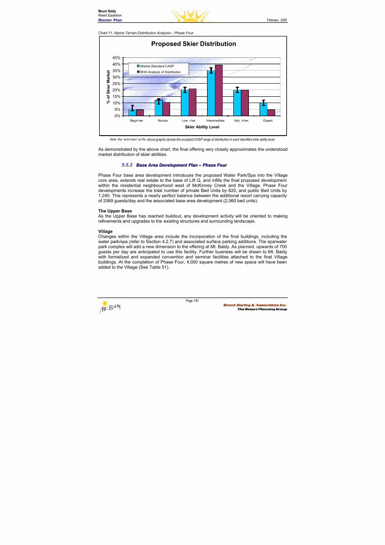
8/12/2019 Mount Baldy
http://slidepdf.com/reader/full/mount-baldy 179/322
Mount BaldyResort Expansion
Master Plan February 2005
Page 161 Brent Harley & Associates Inc.
The Resort Planning Group
Chart 11. Alpine Terrain Distribution Analysis – Phase Four
Proposed Skier Distribution
0%
5%
10%
15%
20%
25%
30%
35%
40%
45%
Beginner Novice Low Inter. Intermediate Adv. Inter. Expert
Skier Ability Level
% o f S k i e r M a r k e t
Market Standard CASP
BHA Analysis of Distribution
Note: the ‘error bars’ on the above graphic denote the accepted CASP range of distribution in each identified skier ability level.
As demonstrated by the above chart, the final offering very closely approximates the understoodmarket distribution of skier abilities.
5.5.2 BBaassee A Ar r eeaa DDeev v eel l oo p pmmeennt t P P l l aann – – P P hhaassee F F oou u r r
Phase Four base area development introduces the proposed Water Park/Spa into the Villagecore area, extends real estate to the base of Lift Q, and infills the final proposed development
within the residential neighbourhood west of McKinney Creek and the Village. Phase Fourdevelopments increase the total number of private Bed Units by 820, and public Bed Units by1,240. This represents a nearly perfect balance between the additional resort carrying capacityof 2069 guests/day and the associated base area development (2,060 bed units).
The Upper Base As the Upper Base has reached buildout, any development activity will be oriented to makingrefinements and upgrades to the existing structures and surrounding landscape.
VillageChanges within the Village area include the incorporation of the final buildings, including thewater park/spa (refer to Section 4.2.7) and associated surface parking additions. The spa/water
park complex will add a new dimension to the offering at Mt. Baldy. As planned, upwards of 700guests per day are anticipated to use this facility. Further business will be drawn to Mt. Baldywith formalized and expanded convention and seminar facilities attached to the final Villagebuildings. At the completion of Phase Four, 4,000 square metres of new space will have beenadded to the Village (See Table 51).
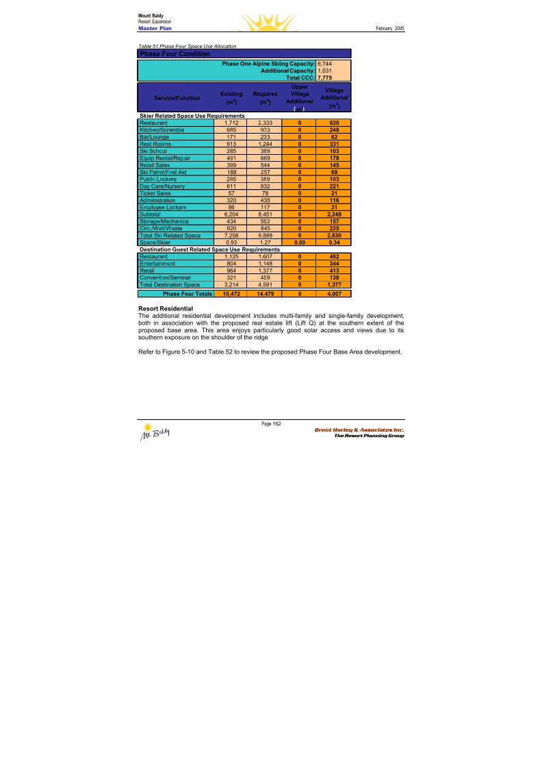
8/12/2019 Mount Baldy
http://slidepdf.com/reader/full/mount-baldy 180/322
Mount BaldyResort Expansion
Master Plan February 2005
Page 162 Brent Harley & Associates Inc.
The Resort Planning Group
Table 51 Phase Four Space Use Allocation
Resort ResidentialThe additional residential development includes multi-family and single-family development,both in association with the proposed real estate lift (Lift Q) at the southern extent of theproposed base area. This area enjoys particularly good solar access and views due to itssouthern exposure on the shoulder of the ridge.
Refer to Figure 5-10 and Table 52 to review the proposed Phase Four Base Area development.
6,7441,0317,775
Service/FunctionExisting
(m2)
Required
(m2)
UpperVillage
Additional
m2
Village
Additional
(m2)
Restaurant 1,712 2,333 0 620Kitchen/Scramble 685 933 0 248Bar/Lounge 171 233 0 62Rest Rooms 913 1,244 0 331Ski School 285 389 0 103Equip Rental/Repair 491 669 0 178Retail Sales 399 544 0 145
Ski Patrol/First Aid 188 257 0 68Public Lockers 285 389 0 103Day Care/Nursery 611 832 0 221Ticket Sales 57 78 0 21 Administration 320 435 0 116Employee Lockers 86 117 0 31Subtotal 6,204 8,451 0 2,248Storage/Mechanical 434 592 0 157Circ./Wall/Waste 620 845 0 225Total Ski Related Space 7,258 9,888 0 2,630Space/Skier 0.93 1.27 0.00 0.34
Restaurant 1,125 1,607 0 482Entertainment 804 1,148 0 344Retail 964 1,377 0 413Convention/Seminar 321 459 0 138Total Destination Space 3,214 4,591 0 1,377
Phase Four Totals 10,472 14,479 0 4,007
Total CCC:
Skier Related Space Use Requirements
Phase Four Condition
Phase One Alpine Skiing Capacity:Additional Capacity:
Destination Guest Related Space Use Requirements
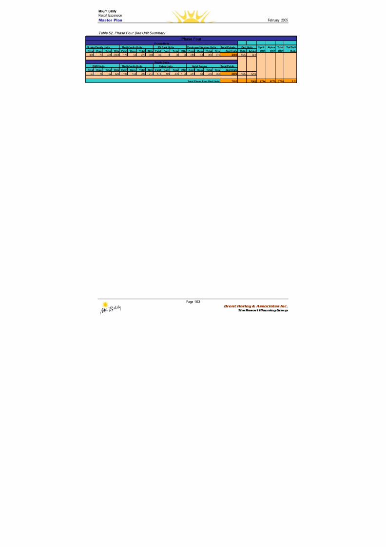
8/12/2019 Mount Baldy
http://slidepdf.com/reader/full/mount-baldy 181/322
Mount BaldyResort Expansion
Master Plan February 2005
Page 163 Brent Harley & Associates Inc.
The Resort Planning Group
Table 52. Phase Four Bed Unit Summary
Single Family Units Multi-family Units RV Park Units Employee Housing Units Total Private Uphill Alpine Total Tot/Built
Exist Com. Total BUs Exist Com. Total BUs Exist Com. Total BUs Exist Com. Total BUs Bed Units Ratio Added CCC CCC CCC Ratio
358 70 428 2568 176 50 226 904 30 0 30 60 285 100 385 770 4302 55% 820
B&B Units Multi-family Units Cabin Units Hotel Rooms Total Public
Exist Com. Total BUs Exist Com. Total BUs Exist Com. Total BUs Exist Com. Total BUs Bed Units
37 15 52 520 198 105 303 1212 175 100 275 1100 244 135 379 758 3590 45% 1240
7892 2060 6744 6778 7776 1.01
Bed Units
Public Beds
Total Phase Four Bed Units
Private Beds
Phase Four
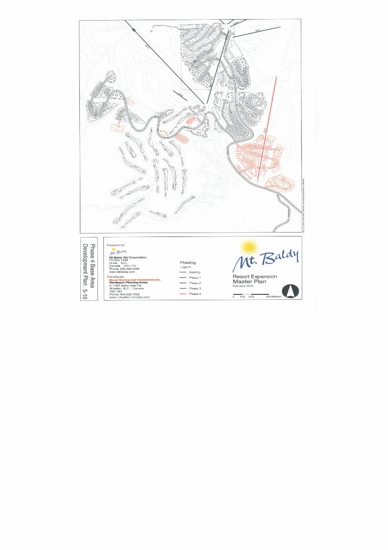
8/12/2019 Mount Baldy
http://slidepdf.com/reader/full/mount-baldy 182/322

8/12/2019 Mount Baldy
http://slidepdf.com/reader/full/mount-baldy 183/322
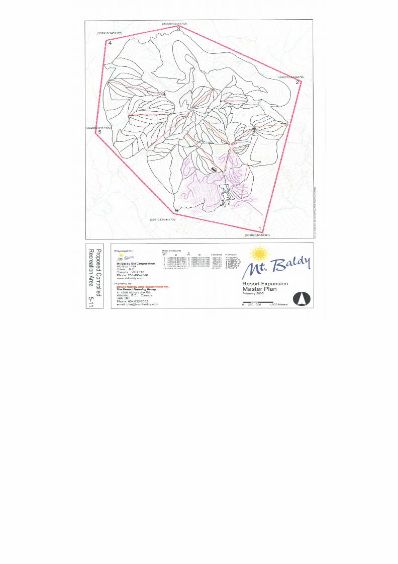
8/12/2019 Mount Baldy
http://slidepdf.com/reader/full/mount-baldy 184/322
8/12/2019 Mount Baldy
http://slidepdf.com/reader/full/mount-baldy 185/322
Mount BaldyResort Expansion
Master Plan February 2005
Page 167 Brent Harley & Associates Inc.
The Resort Planning Group
66..00 SSeer r vviicciinngg aanndd IInnf f r r aassttr r uuccttuur r ee
TRUE Consulting Group has been involved with infrastructure (water supply and sanitary sewer)at Mt. Baldy since the mid 1980’s. On the basis of their background knowledge of infrastructureat Mt. Baldy and their participation in the upgrading plans for this infrastructure, TRUE is in the
position to describe, in conceptual detail, the servicing requirements for the proposed expansionplan.
The current water supply and sanitary sewer infrastructure at Mt. Baldy were designed for theexisting development, which in total represents a buildout capacity of approximately 1,000 bedunits. The four-phase development plan for Mt. Baldy as described herein would, at buildout,represent a capacity to accommodate approximately 8,000 bed units, an 800% increase ascompared to existing. Associated with the development plan, water supply and sanitary sewerinfrastructure at Mt. Baldy will therefore have to be substantially expanded. The followingSections provide, in conceptual detail, a description of water and sanitary sewer infrastructurenecessary for the proposed development plan.
66..11 WWAATTEERR
Water supply is presently provided to the Mt. Baldy Ski Area from two impoundment reservoirsdesignated as the, “upper and lower reservoirs”. Water is conveyed to these two openreservoirs from diversions on the west and east forks of McKinney Creek. From these tworeservoirs, water is supplied by gravity to the resort with ultraviolet disinfection (UV) being theonly treatment provided. The adequacy of the existing surface water supplies to service theresort has been a historical concern of regulatory agencies. While the adequacy of the existingsurface water sources has been a longstanding concern of regulatory agencies, at no time inthe period from mid 1980’s to date has there been a situation of inadequate supply.
The Province of British Columbia passed the Drinking Water Protection Act in 2003 and
guidelines for domestic water supplies established by the Interior Health Authority pursuant tothe Drinking Water Protection Act require treatment (filtration) and disinfection of all surfacewater supplies or groundwater under the influence of surface water. Associated with theMt. Baldy development plan as presented herein, water supply quantity and treatment fullycomplying with Interior Health Authority guidelines represent the principal design issues for thewater supply system.
To provide adequate water supply to the development plan as presented herein, an 800%increase in water supply capacity as compared to existing will be required. Recognizing thehistorical capacity concerns with the existing surface water sources, groundwater is suggestedfor the water source for the proposed development. Groundwater sources have the possibleadvantage of requiring less treatment requirements in order to fully comply with Interior Health
Authority design guidelines for community water supply systems.
Conceptually, water supply infrastructure for the Mt. Baldy development plan as describedherein is illustrated on Figure 6-1 and would comprise the following:
• groundwater (wells) supply sources conceptually shown within the McKinney Creekdrainage course south of the existing developed area of the resort. For the developmentbuild out of approximately 8,000 bed units, water supply requirements are estimated tobe in the range of 30 to 40 L/sec. It is anticipated that this supply capacity will likelyrequire a minimum of 3 groundwater sources. Extensive test drilling in the vicinity of the
8/12/2019 Mount Baldy
http://slidepdf.com/reader/full/mount-baldy 186/322
Mount BaldyResort Expansion
Master Plan February 2005
Page 168 Brent Harley & Associates Inc.
The Resort Planning Group
existing development has not resulted in the identification of significant groundwaterresources hence the conceptual illustration of groundwater sources south of the existingresort area.
• a 2000m3 reservoir with a design full water elevation of 1760m approximately. At this
elevation, the development plan can be serviced by two pressure zones and at the sametime maintaining the ability of proposed well sources to pump directly to the reservoir.
• a primary water supply main following the alignment of the resort access road.Preliminary calculations suggest that a 250mm main would be adequate for fire flowsupply purposes to all phases of the development plan.
• a separate reservoir having a full water elevation of about 1830m and a capacity of200m3 to supply the existing development and higher elevation areas of Phase Three.This reservoir would in the final analysis be supplied by a booster station from the 1760reservoir and pressure zone.
In the initial phases of the implementation of the Mount Baldy development plan, it is essentialthat assessment studies be undertaken to confirm the availability of adequate groundwater. It isenvisioned that this phase of assessment would include test drilling. Assuming that adequategroundwater resources are identified, the existing upper and lower reservoirs and supply mainswould be abandoned as domestic supply systems. These works do however represent thepotential for an irrigation water source for the proposed golf course.
Phasing of the water system concept plan as presented herein has not been assessed in detail.Phasing will in the final analysis be dependent on the capacity and location of groundwaterwells. Initial construction may involve the proposed 1830m reservoir and improvements to theexisting supply system. These works would address existing system deficiencies and wouldrepresent the opportunity of service to portions of Phase One.
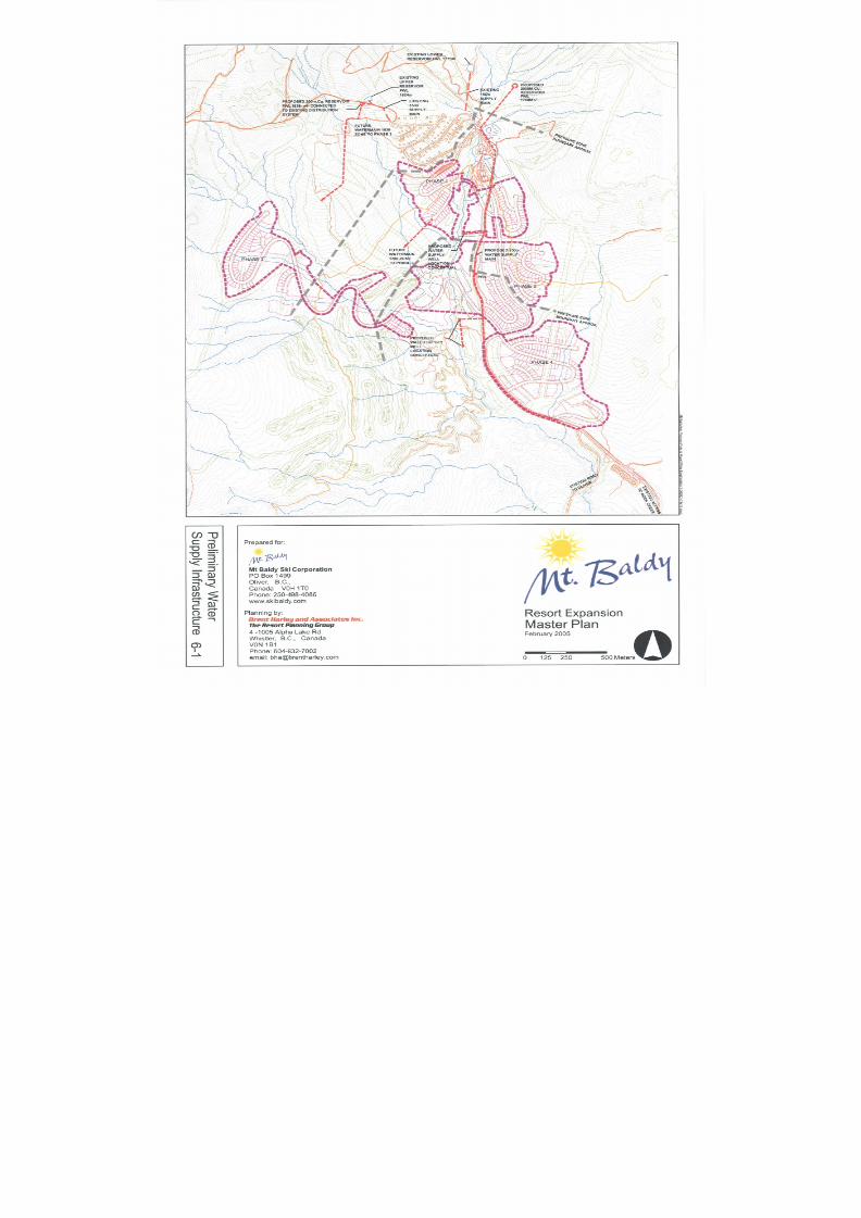
8/12/2019 Mount Baldy
http://slidepdf.com/reader/full/mount-baldy 187/322
8/12/2019 Mount Baldy
http://slidepdf.com/reader/full/mount-baldy 188/322
Mount BaldyResort Expansion
Master Plan February 2005
Page 170 Brent Harley & Associates Inc.
The Resort Planning Group
66..22 SSAANNIITTAARR Y Y SSEEWWEERR SS Y YSSTTEEMM
Existing development at Mt. Baldy is serviced by a conventional gravity sewage collectionsystem to a treatment system located adjacent to the Mt. Baldy access road in the areadesignated as Phase One of the development plan. Treatment at this location is provided by a
rotating biological contactor (RBC) treatment plant, constructed in the early 1980’s, and a twocell aerated lagoon system, constructed in the mid 1990’s. The RBC and aerated lagoons areintended to be operated in series however actual flows to 2004 have been significantly less thandesign flows with the result that the RBC components have not been operated since the aeratedlagoons were constructed.
Wastewater effluent from the treatment plant is disposed to ground utilizing an infiltration basinsystem located southeast of the junction of the Oliver and Rock Creek Access Roads. Thisinfiltration basin system was constructed in the mid 1990’s with wastewater conveyed from thetreatment plant by a 150mm pipeline located adjacent to the access road to the resort.
Conceptually, sanitary sewer service for the Mt. Baldy development plan as described herein isillustrated on Figure 6-2 and would comprise the following.
• abandonment of the existing treatment plant (RBC and aerated lagoons) andconstruction of a new treatment facility at a location in the vicinity of the existinginfiltration basins. This treatment facility would be constructed in phases as the resortdevelopment proceeds and would be well separated from all areas where developmentis proposed. There are operation and maintenance advantages associated with thetreatment system being located in the immediate vicinity of the disposal system.
• expansion of the existing infiltration basin system concurrent with the implementation ofthe development plan. Hydrogeological assessments of the existing infiltration systemundertaken in 1995 suggest infiltrative capacities equivalent to 2,000 to 3,000 bed units.Concurrent with the implementation of the development plan, additional assessments ofthe infiltration system will be necessary to confirm capacity for the four phasedevelopment plan.
• a gravity trunk sewer generally following the alignment of the existing Mt. Baldy AccessRoad from the existing treatment plant to the proposed treatment plant site to be locatedadjacent to the infiltration basin system. This trunk sewer will likely be 250mm diameterand would collect wastewater by gravity from all four development phases. No sewagepumping stations are envisioned as being necessary to service the proposeddevelopment.
Concurrent with Phase One of the development plan, relocation plans for the wastewatertreatment plant should be assessed. Subject to a review of actual flows and treatment systemperformance, it is anticipated that some portion of development Phase One could be servicedby existing treatment works. Concurrent with Phase One however, it is important that a detailedplan including site requirements be developed for the wastewater treatment plant relocation andphased construction.
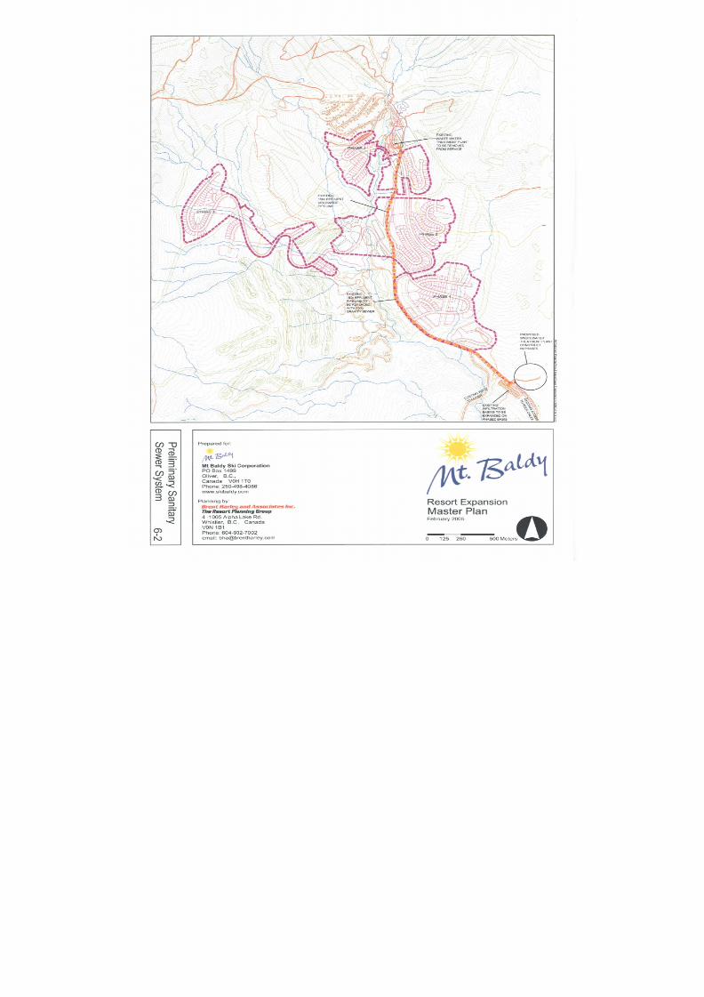
8/12/2019 Mount Baldy
http://slidepdf.com/reader/full/mount-baldy 189/322
8/12/2019 Mount Baldy
http://slidepdf.com/reader/full/mount-baldy 190/322
Mount BaldyResort Expansion
Master Plan February 2005
Page 172 Brent Harley & Associates Inc.
The Resort Planning Group
66..33 SSOOLLIIDD WWAASSTTEE DDIISSPPOOSSAALL
The MBSC understands its need for an efficient procurement of a material supply stream.However, MBSC is highly committed to developing a procurement strategy that employsupstream solutions to minimize, and whenever possible avoid the use of inappropriate products
and/or excessive packaging.
Acknowledging that material flows are an essential component of community and resortcommunity systems, MBSC will incorporate detailed recycling systems throughout it operations,and will undertake a feasibility assessment for diverting organic wastes to a communitycomposting system.
Finally, the MBSC will continue to work with the Regional District to ensure that both effectivesolid waste disposal systems and associated landfill space is available throughout Mt. Baldy’sphased growth. Further it will design its resort-wide waste protocols and procedures to limit allpotential negative environmental impacts associated with landfill content; operate all solid wastedisposal systems consistent with their Bear Management Plan; and through their environmental
management plan incorporate a long-term strategy for becoming the first ‘zero-waste’ resort inNorth America.
66..44 PPOOWWEERR
Due to both a history of neighbourhood brown outs, and the impending expansion plans, theMBSC and FortisBC have met for a series of meetings over the last 18 months. During thesemeetings, FortisBC was advised as to the general scope and scale of planned futuredevelopment at Mount Baldy. Representatives from FortisBC have indicated that theses plansdo not present any critical obstacles to the ongoing provision of reliable power. Further,FortisBC indicated that general upgrades to the area are already planned as part of a largerarea-wide upgrade.
To date, FortisBC has already improved the primary transformer at the base of the resortthrough upgrades to the existing amperage protection system. Other identified upgrades to thelocal power infrastructure includes:
• Relocation of the existing substation to the Rock Creek area (potentially during thesummer of 2005)
• Further upgrades to both the base area and mountain top transformers (phased to beconcurrent with the phased development of the resort area)
In summary, to ensure that the resort’s power needs are met reliably and consistentlythroughout all phases of the resort’s growth, MBSC is committed to maintaining the ongoing
discussions and open communication with FortisBC (Cory Sinclair).
In an effort to remain consistent to the values and vision of the Resort Expansion Plan, theMBSC has committed to undertaking a detailed ‘alternative and renewable power systemscapacity study’ to explore the feasibility of integrating local renewable energy systems into theresort development. Examples of key opportunities for the development of renewable energy atMount Baldy include: geothermal and geo-exchange systems, solar and photovoltaic andcombined heat and power district heating systems.
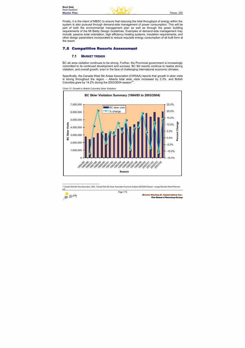
8/12/2019 Mount Baldy
http://slidepdf.com/reader/full/mount-baldy 191/322
Mount BaldyResort Expansion
Master Plan February 2005
Page 173 Brent Harley & Associates Inc.
The Resort Planning Group
Finally, it is the intent of MBSC to ensure that reducing the total throughput of energy within thesystem is also pursued through demand-side management of power consumption. This will bepart of both the environmental management plan as well as through the green buildingrequirements of the Mt Baldy Design Guidelines. Examples of demand-side management mayinclude: passive solar orientation, high efficiency heating systems, insulation requirements, andother design parameters incorporated to reduce requisite energy consumption of all built form atthe resort.
77..00 CCoommppeettiittiivvee RReessoor r ttss AAsssseessssmmeenntt
77..11 MMAARRKKEETT TTRREENNDDSS
BC ski area visitation continues to be strong. Further, the Provincial government is increasinglycommitted to its continued development and success. BC Ski resorts continue to realize strongvisitation, and overall growth, even in the face of challenging international economic climates.
Specifically, the Canada West Ski Areas Association (CWSAA) reports that growth in skier visits
is strong throughout the region – Alberta total skier visits increased by 2.3%, and BritishColumbia grew by 14.2% during the 2003/2004 season79.
Chart 12. Growth in British Columbia Skier Visitation
BC Skier Visitation Summary (1984/85 to 2003/2004)
0
1,000,000
2,000,000
3,000,000
4,000,000
5,000,000
6,000,000
7,000,000
1 9 8 4
/ 8 5
1 9 8 5
/ 8 6
1 9 8 6
/ 8 7
1 9 8 7
/ 8 8
1 9 8 8
/ 8 9
1 9 8 9
/ 9 0
1 9 9 0
/ 9 1
1 9 9 1
/ 9 2
1 9 9 2
/ 9 3
1 9 9 3
/ 9 4
1 9 9 4
/ 9 5
1 9 9 5
/ 9 6
1 9 9 6
/ 9 7
1 9 9 7
/ 9 8
1 9 9 8
/ 9 9
1 9 9 9
/ 0 0
2 0 0 0
/ 0 1
2 0 0 1
/ 0 2
2 0 0 2
/ 0 3
2 0 0 3
/ 0 4
Season
B C S k i e r V i s i t s
-15.0%
-10.0%
-5.0%
0.0%
5.0%
10.0%
15.0%
20.0%
25.0%
P e r c e n t C h a n g e
BC skier vists
% change
79 Canada West Ski Area Association, 2004, “Canada West Ski Areas Association Economic Analysis 2003/2004 Season”, ecosign Mountain Resort PlannersLtd.
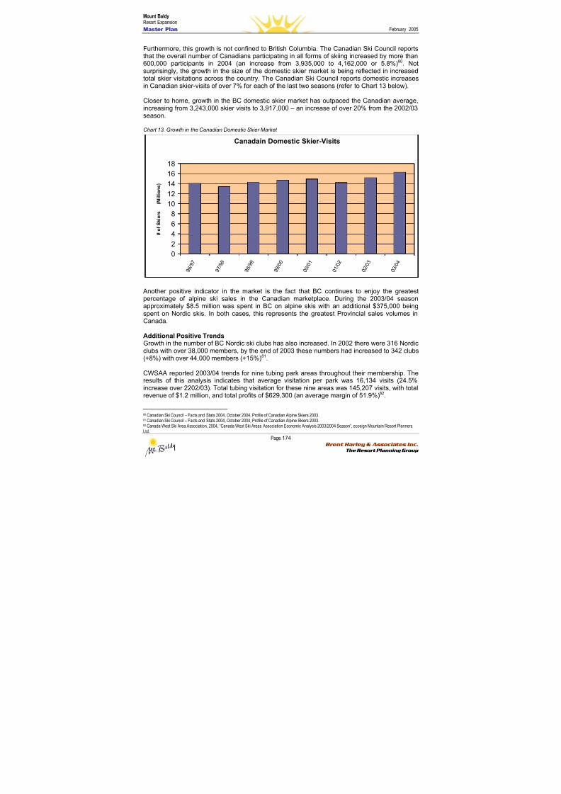
8/12/2019 Mount Baldy
http://slidepdf.com/reader/full/mount-baldy 192/322
Mount BaldyResort Expansion
Master Plan February 2005
Page 174 Brent Harley & Associates Inc.
The Resort Planning Group
Furthermore, this growth is not confined to British Columbia. The Canadian Ski Council reportsthat the overall number of Canadians participating in all forms of skiing increased by more than600,000 participants in 2004 (an increase from 3,935,000 to 4,162,000 or 5.8%)80. Notsurprisingly, the growth in the size of the domestic skier market is being reflected in increasedtotal skier visitations across the country. The Canadian Ski Council reports domestic increasesin Canadian skier-visits of over 7% for each of the last two seasons (refer to Chart 13 below).
Closer to home, growth in the BC domestic skier market has outpaced the Canadian average,increasing from 3,243,000 skier visits to 3,917,000 – an increase of over 20% from the 2002/03season.
Chart 13. Growth in the Canadian Domestic Skier Market
Canadain Domestic Skier-Visits
0
2
4
6
8
10
12
14
16
18
9 6
/ 9 7
9 7
/ 9 8
9 8
/ 9 9
9 9
/ 0 0
0 0
/ 0 1
0 1
/ 0 2
0 2
/ 0 3
0 3
/ 0 4
( M i l l i o n s )
# o f S k i e r s
Another positive indicator in the market is the fact that BC continues to enjoy the greatestpercentage of alpine ski sales in the Canadian marketplace. During the 2003/04 seasonapproximately $8.5 million was spent in BC on alpine skis with an additional $375,000 beingspent on Nordic skis. In both cases, this represents the greatest Provincial sales volumes inCanada.
Additional Positive TrendsGrowth in the number of BC Nordic ski clubs has also increased. In 2002 there were 316 Nordicclubs with over 38,000 members, by the end of 2003 these numbers had increased to 342 clubs
(+8%) with over 44,000 members (+15%)81
.
CWSAA reported 2003/04 trends for nine tubing park areas throughout their membership. Theresults of this analysis indicates that average visitation per park was 16,134 visits (24.5%increase over 2202/03). Total tubing visitation for these nine areas was 145,207 visits, with totalrevenue of $1.2 million, and total profits of $629,300 (an average margin of 51.9%)82.
80 Canadian Ski Council – Facts and Stats 2004, October 2004, Profile of Canadian Alpine Skiers 2003.81 Canadian Ski Council – Facts and Stats 2004, October 2004, Profile of Canadian Alpine Skiers 2003. 82 Canada West Ski Area Association, 2004, “Canada West Ski Areas Association Economic Analysis 2003/2004 Season”, ecosign Mountain Resort PlannersLtd.
8/12/2019 Mount Baldy
http://slidepdf.com/reader/full/mount-baldy 193/322
Mount BaldyResort Expansion
Master Plan February 2005
Page 175 Brent Harley & Associates Inc.
The Resort Planning Group
77..22 MMAARRKKEETT PPOOSSIITTIIOONN
Today, British Columbia is home to some of the most sought after snow-sport destinations in theworld. Names like Whistler, Wiegele, Rossland and the Bugaboos now carry near-mythical
weight with mountain enthusiasts from Melbourne to Munich. And that’s not about to changesoon. Over the years BC entrepreneurs have been bold enough, on the most part, to createinnovative new mountain models inspired by the unique geography of this vast region. BC’sstatus as one of the centres of the snow-sports universe is sure to be burnished by Vancouver’sOlympic venture. As official host to the international sports community for the 2010 WinterGames, the provincial government is committing millions of dollars to promoting and marketingits image worldwide.
As BC’s infrastructure improves – and transportation across the Interior becomes lessproblematic – visitors (both foreign and domestic) will be drawn to explore further and furtherafield. The result: an even greater potential of destinations and experiences – and a much morecomplete story.
Finally, an important emerging trend needs to be identified here. While much of theentrepreneurial energy over the last 20 years was focused on establishing a viable winter-basedmountain tourism business in BC, recent summer initiatives at leading resorts like Whistler haveshown tremendous returns (Whistler now hosts more visitors in the summer than in the winter)Whether mountain biking, climbing, fishing, rafting, exploring – or simply fleeing the urbansummer heat for the cool clean air of the highlands – visitors are increasingly viewing BC’smountain resorts as potential summer destinations as well.
It is worth noting that studies have shown that US “ski tourists” are very active participants inother activities. Summer pastimes include wildlife viewing (51%), hiking/backpacking (41%),cycling (37%), fresh water fishing (31%), motor boating (30%), whitewater rafting (22%), androck climbing (10%). Given their interests (and the high level of commitment they show to theirfavoured sports), it would seem a reasonable assumption that once they’d “discovered” BC as awelcoming winter destination with a full palette of recreational activities, they would be muchmore likely to return here on summer trips.
Like all industries, the mountain tourism business needs to remain flexible and creative in theface of new opportunities and challenges. And while BC is still basking in the success of itsoriginal groundbreaking resort models (places like Whistler/Blackcomb, Mike Wiegele HelicopterSkiing and Fernie Snow Valley), the socio-economic conditions that sustained the growth ofthese enterprises are quickly changing. Consider the following trends:
• The fast-changing demographics in western North America – featuring an influx of newPacific Rim residents who don’t necessarily have a cultural attachment to snow play
• The dramatic rise in number of active seniors – particularly in the Okanagan region --and how various businesses will need to tailor some of their traditional offerings to bettersuit the needs of this group
• The rise in multi-sport participation among families – and the need for mountain resortsto provide a broader and more diverse panoply of activities suited to a wide range oftastes.
• The powerful voice and far-reaching economic clout of the environmental lobby as itpertains to global tourism and mountain resort businesses – and how the growingmarket influence of this group will impact the development of future resorts.
8/12/2019 Mount Baldy
http://slidepdf.com/reader/full/mount-baldy 194/322
Mount BaldyResort Expansion
Master Plan February 2005
Page 176 Brent Harley & Associates Inc.
The Resort Planning Group
• The growing homogeneity of the modern “mountain resort village” model – and the lossof authenticity and sense of place at some of the bigger resorts.
All of these trends point to an opportunity for the creation of a new, “greener” and “friendlier”mountain resort model. A model that is inspired by the past, but responsible to the future – this
is how the MBSC intends to position Mt. Baldy.
At first glance, Mt Baldy’s physical attributes might be dismissed as insubstantial whencompared to the world’s great mountain resorts. This is not necessarily the case, as it’s uniquegeography, 360o access and user-friendly terrain provides a rare opportunity to create a moreintimate, more inclusive mountain experience than has been typical over the last few decades.In fact, Mt Baldy’s ability to achieve a truly sustainable future depends entirely on its ability toact outside the bounds of conventional thinking and re-invent itself in 21st century terms.
In other words, rather than merely following in others’ footsteps, Mt Baldy’s ultimate survivalrests in being able to devise a new mountain model that complements – rather than competeswith – the existing product in the region, while highlighting the area’s inimitable qualities. Theincorporation of an integrated high elevation Nordic experience as intimately related to, ratherthan separate from, an alpine experience; the accessible nature of abundant liftless backcountryterrain; and the incorporation of innovative pricing strategies are all approaches that MBSCbelieves are capable of making this a reality. By providing a unique product, Mt Baldy’sinfluence on the regional ski and resort market should be a positive one. As Mt. Baldy begins tophase in its Expansion Plan, and expand from its current benchmark of approximately 25,000skier visits per year, it intends grow the South Okanagan resort market numbers by providingunique products designed to attract and retain mountain resort guests new to BC resort market.
Through this Plan MBSC envisions a mountain village that celebrates mountain play of all sorts;an all-season resort that features a network of on-mountain activities suitable to the wholefamily – no matter what their previous mountain experience might be. The vision is to design anexperience where dad can take off on his Nordic skis in the morning and hook up for an on-mountain meal with his snowboarding kids at lunchtime – a place where mom and dad canlounge in the spa before dinner while the kids are playing outside on the fully-lit tubing hill.Further, this Plan will give Mount Baldy the ability to provide a summer playground where askein of maintained mountain trails lead to a cornucopia of backcountry experiences – whethermountain-biking or bird-watching, hiking or picnicking.
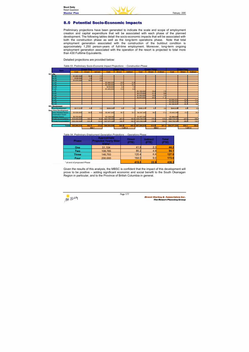
8/12/2019 Mount Baldy
http://slidepdf.com/reader/full/mount-baldy 195/322
Mount BaldyResort Expansion
Master Plan February 2005
Page 177 Brent Harley & Associates Inc.
The Resort Planning Group
Cost Direct Indirect Cost Direct Indirect Cost Direct Indirect Cost Direct Indire
B Lift $1,800,000 16.9 7.7N Lift $199,000 1.9 0.9M Lift $2,070,000 19.5 8.9C Lift $2,980,000 28.0 12.8D Lift $2,350,000 22.1 10.1O Lift $235,000 2.2 1.0E Lift $1,400,000 13.2 6.0J Lift $1,740,000 16.4 7.5H Lift $2,270,000 21.3 9.8P Lift $1,690,000 15.9 7.3
A Lift $2,600,000 24.4 11.2F Lift $2,600,000 24.4G Lift $3,000,000 28.2Q Lift $2,160,000 20.3
Run Development $517,010 4.9 2.2 $699,050 6.6 3.0 $566,210 5.3 2.4 $640,830 6.0
Skier-Related Space $3,926,800 36.9 16.9 $5,967,600 56.1 25.7 $4,047,400 38.0 17.4 $5,662,000 53.2Destination GuestRelated Space $2,703,800 $2,338,000 $1,877,200 $2,964,400
Public Accomodation $19,500,000 183.3 83.9 $42,750,000 401.9 183.8 $29,250,000 275.0 125.8 $46,500,000 437.1 2Private Accomodation $35,250,000 331.4 151.6 $37,875,000 356.0 162.9 $23,250,000 218.6 100.0 $30,750,000 289.1 1
Totals $65,966,610 594.7 272.0 $96,594,650 886.0 405.3 $67,290,810 614.9 281.3 $94,277,230 858.3 3
1,251.0
Phase Four Item
Phase One Phase Two Phase Three
i Lifts
n. Develoment
se Area Development
866.7 1,291.3 896.2
88..00 PPootteennttiiaall SSoocciioo--EEccoonnoommiicc IImmppaaccttss
Preliminary projections have been generated to indicate the scale and scope of employmentcreation and capital expenditure that will be associated with each phase of the planneddevelopment. The following tables detail the socio-economic impacts that will be associated with
both the construction phase as well as the long-term operations phase. Note that totalemployment generation associated with the construction of the buildout condition isapproximately 1,250 person-years of full-time employment. Moreover, long-term ongoingemployment generation associated with the operation of the resort is projected to total morethan 430 Fulltime Equivalents.
Detailed projections are provided below:
Table 53. Preliminary Socio-Economic Impact Projections – Construction Phase
Table 54. Preliminary Employment Generation Projections – Operations Phase
PhaseApproximate
Projected Yearly SkierVistis*
Direct(FTE)
Indirect(FTE)
Total(FTE)
One 51,104 41.9 2.3 44.2
Two 108,785 89.2 4.9 94.1
Three 146,793 120.4 6.6 127.0
Four 200,000 164.0 9.0 173.0* at end of proposed Phase 415.5 22.8 438.3
Given the results of this analysis, the MBSC is confident that the impact of this development willprove to be positive – adding significant economic and social benefit to the South OkanaganRegion in particular, and to the Province of British Columbia in general.
8/12/2019 Mount Baldy
http://slidepdf.com/reader/full/mount-baldy 196/322
Mount BaldyResort Expansion
Master Plan February 2005
Page 178 Brent Harley & Associates Inc.
The Resort Planning Group
99..00 MMaannaaggeemmeenntt aanndd OOwwnneer r sshhiipp SSttr r uuccttuur r ee
In the Fall of 2002, the three partners of the predecessor Mountain Recreation, LLP (an IdahoLimited Liability Partnership)(“MRLP”) began a review of the possible acquisition of the MountBaldy Ski Area from the Mount Baldy Strata Corporation KAS 1840. On May 2, 2003, MRLP
and the Strata formally entered into a letter of intent to purchase the Mt. Baldy Ski Area. OnMay 21, 2003, MRLP and Slotman Enterprises, LTD, Inc. (“Slotman”) formally entered into abinding offer to purchase the remaining privately held land (the “Wapiti Subdivision”)immediately adjacent to the Ski Area. At their June 23, 2003 annual general meeting, the strataowners approved the letter of intent and agreed to enter into a binding purchase and saleagreement by a vote of 101 to 1. In January 2004, MRLP and its nominees completed thepurchase of the Wapiti Subdivision and in April 2004, the purchase of the Mount Baldy Ski Areawas completed.
Simultaneous to the acquisitions a new corporate structure was completed. All of MRLP’sassets and purchase and sale agreements were transferred to Mountain Investments, Inc., anIdaho Corporation (“MII”) and Winter Recreation, ULC, a Nova Scotia Unlimited Liability
Corporation (“WRU”). MII is the US Holding Company, which has as its only asset aninvestment in WRU. The three founders, Brent Baker, Brett Sweezy and Robert Boyle are themajority shareholders and directors of MII. WRU is the Canadian Holding Company, whichowns 100% of the two operating companies, Mount Baldy Ski Corporation, (“MBSC”) a BritishColumbia Corporation which operates the ski resort and Mount Baldy Real Estate, ULC, a NovaScotia Unlimited Liability Corporation (“MBRU”) which owns and manages all of the real estateat Mt. Baldy.
The three founders and initial Directors of all the Companies referenced above are:
Robert Boyle, Director and V.P. of Finance: Bob brings more than 30 years of accountingand financial experience to this project. Bob is currently the President of Robert Boyle, CPA,
PA, a Director of Lifestream Technologies, Inc., and an active investor in real estate located inNorth Idaho (USA). Prior to this partnership, Bob served for 15 years as President of Boyle andStoll, CPAs specializing in taxation and business acquisitions and sales on behalf of a widevariety of clients. Boyle’s background also includes seven years with KPMG Peat Marwick inSouthern California working as an auditor and tax manager.
Brent Baker, Director and V.P. of Real Estate: Brent brings over 20 years of construction,development and real estate investment to the corporation. Brent is currently President andCEO of Baker Construction and Development, Inc., licensed in Idaho, Montana and California.He is the general partner of the Brent and Laura Baker Family Limited Partnership, where heactively manages nearly USD $5 million. Brent has recently been appointed by the Governor ofIdaho to sit on a newly created commission to protect Lake Pend d’Oreille, the largest lake in
Idaho.
Brett Sweezy, Director and President: Brett brings capital fund raising and formation, investorrelations and over 15 years of financial experience to the corporation. Brett is a Certified Public
Accountant and recently resigned as the Chief Financial Officer of Lifestream Technologies,Inc., a publicly traded medical device design and marketing company. At Lifestream, Brett waspersonally involved in securing nearly USD $20 million of new financing, management of nearly30 employees and Lifestream’s growth from $0 sales to over $5 million annually. Prior to 1999,Brett served as CFO and Treasurer of Secured Interactive Technologies, Inc., and President ofBrett R. Sweezy, CPA, PA, a public accounting firm.
8/12/2019 Mount Baldy
http://slidepdf.com/reader/full/mount-baldy 197/322
Mount BaldyResort Expansion
Master Plan February 2005
Page 179 Brent Harley & Associates Inc.
The Resort Planning Group
The present Mt. Baldy management team consists of Tim Foster, Russell Karp and Matt Koenig.Collectively they possess nearly 40 years of ski resort related experience.
Tim Foster: General Manager. Tim brings over 18 years of ski area related experience to hisposition. Tim has worked in this position for 4 years. Prior to his position with Mt. Baldy, Timserved for 3 years as the Sport Director for Grouse Mountain Resorts, 1 year with Hidden ValleySki Area as Snow School & Marketing Director, and 6 years with Shames Mountain Ski Area asGuest Services Manager. Tim entered the ski industry teaching skiing and snowboarding at theage of 16. Tim has completed the 2-year Ski Resort Operations & Management (SROAM)diploma program at Selkirk College, and holds a diploma in Hotel and Restaurant Administrationfrom the Southern Alberta Institute of Technology. In addition Tim is a Canadian Ski Instructors
Alliance (CSIA) Level III ski instructor, and a Canadian Ski Coaches Federation (CSCF) Level IIski coach. Tim is a level 1 trainer for the (CSIA), and is a past representative for BritishColumbia on the (CSIA) national technical committee. Currently Tim is on the industry advisorycommittee for the (SROAM) program, and represents the small ski area committee for theCanada West Ski Areas Association.
Russell Karp: Operations & Maintenance Manager. Russell brings over 11 years of ski arearelated experience to his position. Russell has worked in this position for 6 years. Prior to hisposition with Mt. Badly, Russell served for 5 years in the maintenance, grooming and liftoperations departments at Apex Mountain Resort. Russell was responsible for therefit/construction of the Mt. Baldy chairlift, and has worked on several other lift installationsincluding the new gondola at Sunshine Village. Russell holds a Journeyman AutomotiveMechanic designation, and has completed several Ski Resort Operations courses throughSelkirk College. In addition Russell has completed numerous operations related trainingcourses, including the Train the Trainer program recognized by the Province of British Columbiafor training lift operations personnel.
Matt Koenig: Patrol/Risk Management & Lift Operations Supervisor. Matt brings 9 years of skiarea related experience to his position. Matt has worked in this position for 5 years. In additionMatt works with the British Columbia Ambulance Service as a Paramedic. Prior to his positionwith Mt. Badly, Matt served for 4 years in the patrol & lift operations departments at ManningPark Resort. Matt has completed the 2-year Ski Resort Operations and Management diplomaprogram (SROAM) at Selkirk College. In addition Matt holds numerous first aid relateddesignations, and is a trainer for National Ski Patrol (NSP) first aid program. Matt hascompleted the Train the Trainer program recognized by the Province of British Columbia fortraining lift operations personnel. Matt holds certification in the Canadian Association ofSnowboard Instructors (CASI) as a level 1 snowboard instructor. He is an avid snowboarderwho loves to ride, and has a passion for sailing in the off-season.
Other professionals that have been involved with this project include:
• Colliers International Real Estate Agents
• Brent Harley and Associates Inc. TheResort Planning Group
• Oliver District Community Economicand Development Society
• Osoyoos Indian Band DevelopmentCorporation
• Mott, Rutherford, Welch & Greig, an Association of Legal Professionals.
• Arcas Consulting Archaeologists Ltd.• Destination Osoyoos
• Snowy River Resources Ltd. • True Consulting Ltd.
8/12/2019 Mount Baldy
http://slidepdf.com/reader/full/mount-baldy 198/322
Mount BaldyResort Expansion
Master Plan February 2005
Page 180 Brent Harley & Associates Inc.
The Resort Planning Group
The skills and expertise of all of these organizations, as well as other leading professional firmswill continue to contribute to the quality, diligence and professionalism of this project.
99..11 FFIINNAANNCCIIAALL CCAAPPAABBIILLIITTIIEESS
The climate for ski resort development in BC is currently very positive. Government initiatives,cumulating with the recent release of the British Columbia Resort Strategy and Action Plan,strongly support and encourage resort development in the Province. The resort real estatemarketplace continues to rapidly appreciate with demand for new resort properties. Finally, thecontinued success of BC’s signature resorts, particularly those located in the Okanagan,demonstrates that BC is a worldwide destination with the ability to support new resortdevelopment.
As envisioned, MBSC believes that their unique resort concept will effectively mitigate thefinancial risk and preserves long-term economic sustainability. The development philosophy ofMBSC rotates around the creation of well-balanced and integrated resort development in aneconomically viable fashion on a phase-by-phase basis. Each phase of development will be
market driven, with the beginning of the next phase only being initiated as market demanddictates. While most resorts developed today project hundreds of thousands of annual skiervisits, sometimes requiring a 10-fold increase, MBSC is projecting at full buildout atapproximately 150,000 to 200,000 annual skier visits. Internal analyses have led MBSC to theconclusion that these projections are financially attainable and that this goal is attainable.
MBSC’s vision for the resort is focused on skier quality and mountain experience, and as suchwill use traditional fixed grip chair technology to provide lift access. These lifts are, on average,less than fifty percent the capital cost of high-speed detachable lifts. The annual costs tomaintain and operate these lifts are considerably less as well. These attributes, along with theSherpa-assisted backcountry concept, will allow MBSC to open significant new terrainaffordably, without having to project unattainable new skier visits.
Aside from their financially responsible development program, MBSC posses the followingfundamentals as indications of their financial capacity to complete this resort developmentproject:
• MBSC currently owns approximately eight hectares of developable land locatedimmediately adjacent to the existing ski area base. The development of this land will beused to fund the Phase One infrastructure and once complete, will effectively double thesize of the existing village. This growth will establish the critical mass of on-mountainaccommodations required catalyze the future development plans.
• MBSC founders have collectively over 45 years of collective financial and business-related experience. Specifically, two founders, Robert Boyle and Brett Sweezy are
Certified Public Accountants who have advised business clients on a regular basis. BrettSweezy has extensive experience in fundraising, having assisted his previous employeracquire over $20 million in debt and equity. The third primary partner – Brent Baker – iscurrently the president of a successful construction and development company.
• The founders of MBSC have a combined net worth in excess of $7.5 million and havealready demonstrated their ability to finance the initial acquisition of the ski resort andassociated real estate.
• MBSC is currently in discussions with numerous qualified investors and developers whohave expressed interest in financing up to $5 million for the development of Phase Oneinfrastructure development.

8/12/2019 Mount Baldy
http://slidepdf.com/reader/full/mount-baldy 199/322
Mount BaldyResort Expansion
Master Plan February 2005
Page 181 Brent Harley & Associates Inc.
The Resort Planning Group
• Following the completion of the acquisition, and before the announcement of the MasterPlan Vision, real estate prices at Mt. Baldy appreciated over 400%, to over $80,000 persingle-family home lot.
• MBSC has recently completed a $1.4 million debt financing package with Vernon CreditUnion to support the completion of the Master Plan, fund operations and purchase the
six unit condominium located directly adjacent to the ski area base.• MBSC has received preliminary commitments from several lending institutions indicating
their desire to loan up to $7.5 million for ski area improvements.• The Osoyoos Indian Band, a recognized, progressive and business-minded First Nation
Band is a 2.5% owner of MBSC.
8/12/2019 Mount Baldy
http://slidepdf.com/reader/full/mount-baldy 200/322
Mount BaldyResort Expansion
Master Plan February 2005
Page 182 Brent Harley & Associates Inc.
The Resort Planning Group
1100..00 CCoonncclluussiioonnss
With the intent of contributing to the ongoing development of a successful four-season tourismsector in the South Okanagan, the goal of the Mount Baldy Ski Corporation is to create asignature product to anchor the region’s winter tourism amenities. The Mount Baldy Ski
Corporation believes that unique natural attributes of the Mt. Baldy area, the growth of tourisminfrastructure throughout the Southern Okanagan region, combined with the unique plan andpartnership structure described within this document provide an unprecedented opportunity tomake this goal a reality.
To that end:
Mt. Baldy will be nurtured as a special place, where the outdoor environment iscelebrated, where people are valued, and the timeless spirit of skiing and mountain-playstill thrive!
MBSC believes that this Expansion Plan carefully outlines a comprehensive approach to
ensuring the long-term success of the Mt. Baldy Resort. The unique all-mountain product, thecompetitive positioning, the strong sense of environmental responsibility and the carefullyconstructed Implementation Plan provide the tools requisite to ensure Mt. Baldy provides asuccessful compliment to the area’s existing tourism products, as well as positive social andeconomic impacts on the regional economy.
The Mount Baldy Ski Corporation is excited about all the possibilities inherent in this Plan, andlooks forward to achieving the Provincial support required to bring the visions and goalsdescribed within this document to fruition. Any advice, commentary or suggestions for improvingor supporting the efforts of MBSC in this respect are both welcomed and appreciated.

8/12/2019 Mount Baldy
http://slidepdf.com/reader/full/mount-baldy 201/322
Mount BaldyResort Expansion
Master Plan February 2005
Page 183 Brent Harley & Associates Inc.
The Resort Planning Group
1111..00 AAppppeennddiicceess
Appendix 1 Snowy River Resources Ltd. Report
Appendix 2 Environmental Assessment Office – Letter re: non-reviewable status
Appendix 3 Detailed Terrain and Carrying Capacity Assessments – Phase 4 (Buildout) Condition

8/12/2019 Mount Baldy
http://slidepdf.com/reader/full/mount-baldy 202/322
AA p p p p e enn d d i i xx 1 1
S n ow y Ri v er R e s o ur c e
s L t d .–F ul l R e p or t
8/12/2019 Mount Baldy
http://slidepdf.com/reader/full/mount-baldy 203/322
Environmental Management Plan
Wildlife, Riparian, Fish Habitat and Water Quality Values within the
Mt. Baldy Ski Hill Proposed Expansion Area
Prepared for:
Mt. Baldy Ski Corporation
Oliver BC
Prepared by:
Doug Wahl, MAppSc, RPBio, CPESC
Habitat Biologist
Habitat Protection for Natural Resource, Urban & Transportation Development
SNOWY RIVER RESOURCES LTD.13807 Latimer Ave., Summerland BC V0H 1Z1 (250) 809-9093 [email protected]
8/12/2019 Mount Baldy
http://slidepdf.com/reader/full/mount-baldy 204/322
Snowy River Resources Ltd.
Table of Contents
1.0 INTRODUCTION.......................................................................................................................1
2.0 ECOLOGICAL DESCRIPTION OF THE STUDY AREA....................................................2
3.0 ASSESSMENT OF NATURAL RESOURCE VALUES AND ACTIONS THAT
WILL BE TAKEN TO MITIGATE ENVIRONMENTAL EFFECTS................................2
3.1 Specific Direction for Resource Use Contained in Strategic Land Use Plans .........................2
3.1.1 Okanagan-Shuswap LRMP ..............................................................................................................2
3.1.2 Kootenay-Boundary LRMP..............................................................................................................2
3.2 Old Growth Management Areas ..............................................................................................5
3.3 Wildlife Habitat Areas .............................................................................................................7
3.4 Ungulate Winter Range............................................................................................................7
3.5 Rare and Endangered Species..................................................................................................7
3.6 Wildlife habitat suitability for elk, mule deer, lynx, Williamson’s sapsucker and white-headed woodpecker........................................................................................................................9
3.6.1 Methods ..........................................................................................................................................10
3.6.2 Results ............................................................................................................................................10
3.6.2.1 Elk.............................................................................................................................................10
3.6.2.2 Mule Deer.................................................................................................................................13
3.6.2.3 Lynx ..........................................................................................................................................14
3.6.2.4 White-Headed Woodpecker ......................................................................................................15
3.6.2.5 Williamson’s Sapsucker............................................................................................................15
3.7 Bear Management Plan: Minimizing the Potential for Bear-Human Conflicts .....................15
3.8 Water Quality.........................................................................................................................17 3.8.1 McKinney Community Watershed.................................................................................................17
3.8.2 Erosion and sediment control best management practices..............................................................18
3.9 Riparian and Fish Habitat ......................................................................................................19
3.9.1 Status of fish distributions within the study area ............................................................................19
3.9.1.1 Methods ....................................................................................................................................19
3.9.1.2 Results.......................................................................................................................................19
3.9.2 Riparian Management Area Best Management Practices...............................................................20
4.0 SUMMARY AND RECOMMENDATIONS ..........................................................................23
5.0 REFERENCES..........................................................................................................................27
Appendix 1A: BEC Subzone/Variant Map, Boundary Forest District ........................................28
Appendix 1B: BEC Subzone/Variant Map, Penticton Forest District .........................................29
Appendix 2: Okanagan-Shuswap LRMP - Resource Management Zones adjacent to the study
area boundary...............................................................................................................................30
Appendix 3A: Planned and approved activities by OGMA within the study area ......................31
i
8/12/2019 Mount Baldy
http://slidepdf.com/reader/full/mount-baldy 205/322
Snowy River Resources Ltd.
Appendix 3B: E-mail correspondence between Frank Wilmer, Senior Planner, MSRM, Nelson
and Doug Wahl, Habitat Biologist, Snowy River Resources Ltd. regarding the status and
management of OGMAs. .............................................................................................................36
Appendix 3C:...............................................................................................................................40
Appendix 4: Record of e-mail communication between Snowy River Resources Ltd. and theConservation Data Centre. ...........................................................................................................41
List of Tables
Table 1: Kootenay-Boundary LRMP Implementation Strategy objectives within the B-I01
Kettle-Granby Resource Management Zone..................................................................................4
Table 2: OGMAs located within the study area boundary and estimated clearing required to
accommodate planned infrastructure. ............................................................................................5
Table 3: Habitat rating schemes used elk, mule deer, lynx, Williamson’s sapsucker and white-
headed woodpecker......................................................................................................................10
Table 4: Ecosystem units and structural stages rated at moderate, moderately high, and high
habitat suitability for elk within the study area............................................................................11
Table 5: Ecosystem units and structural stages rated as moderate, moderately high, and high
habitat suitability for mule deer within the study area.................................................................13
Table 6: Ecosystem units and structural stages rated as moderate and high habitat suitability
for lynx within the study area. .....................................................................................................14
Table 7: Reserve Zone and Management Zone widths for streams within a Community
Watershed. ...................................................................................................................................18
Table 8: Riparian Management Area best management practices ....................................................20
Table 9: Wildlife and wildlife habitat resource values within the study area. ..................................23
Table 10: Water quality, riparian and fish habitat values within the study area ...............................25
List of Figures
Figure 1: Location of Mt. Baldy ski area, the study area boundary and the McKinney
Community Watershed boundary. .................................................................................................3
Figure 2: Location of draft OGMAs established within the Kootenay and Kamloops MSRM
regions............................................................................................................................................6
Figure 3 Rumex paucifolius (Alpine Sorrel) shown at left and Figure 4 Mimulus breweri (Brewer’s Monkeyflower) shown at right......................................................................................9
Figure 5: Actual and extrapolated high habitat suitability polygons within the study area
boundary. .....................................................................................................................................12
Figure 6: McKinney Community Watershed boundary....................................................................18 Figure 7: Status of known fish distributions within the study area. ..................................................21
Figure 8: Fish distribution for McKinney Creek...............................................................................22
ii

8/12/2019 Mount Baldy
http://slidepdf.com/reader/full/mount-baldy 206/322
Snowy River Resources Ltd.
1.0 INTRODUCTION
The following document provides a detailed assessment of natural resource values within and
immediately adjacent to the proposed study area of the Mt. Baldy Ski Hill expansion project.
Recommendations and suggested actions for integrating planned development in a manner thatadequately mitigates potential impacts are also included.
From initial concept to final design, the intent of the Mt. Baldy Ski Corporation (MBSC) has been
to develop a base area plan and associated infrastructure that reflects the type, quality, quantity and
sensitivity of natural resource values. Prior to commencing the development of the plan, however,
little information regarding fish and wildlife habitats was available to guide planning activities.
On June 25th, 2004, the MBSC and Brent Harley and Associates met with several governmentagencies including the Ministry of Water, Land and Air Protection (MWLAP), in part, to obtain
guidance and advice on managing identified resource values within the study area.
To further assess the potential natural resource values, and to develop appropriaterecommendations for incorporation into the Master Plan, the MBSC sought additional guidance
and advice from a Registered Professional Biologist. The scope of the services provided by the
Biologist included:
• an assessment of applicable legislation including the Wildlife Act , Migratory Birds
Regulations, Water Act , Fisheries Act and Species at Risk Act , Forest and Range
Practices Act ;
• an assessment of relevant strategic plans, including the Okanagan-Shuswap and
Kootenay Boundary LRMPs;
• an assessment and incorporation of other related legislative initiatives such as the Forest
Planning and Practices Act and Riparian Areas Regulation. These statutes do not
specifically apply to this LWBC application but have components that warrant further
consideration and incorporation. This initiatives include Ungulate Winter Range, the
Identified Wildlife Management Strategy and the Old Growth Management Strategy;
• an assessment of resource information databases maintained by government as well as
local forest licencees;
• communication with MSRM Planners and Species Specialists (CDC), MWLAP
Biologists, WLAP Ecosystems Officers and other independent biologists and species
specialists;
• completion of a habitat suitability assessment, fish inventory assessment and bear
management plan; and,
• consideration and incorporation of published and draft Best Management Practices
(BMPs) authored by government and industry.
Overall, the proposed development represents an exceptionally low risk of environmental harm,
based on the known distribution of wildlife and fisheries values. The following tables provide a
summary of identified resource values and actions proposed by the MBSC to protect and integrate
these resource values within the base area design and associated infrastructure. The detailed
assessment commences in Section 2.
1
8/12/2019 Mount Baldy
http://slidepdf.com/reader/full/mount-baldy 207/322
Snowy River Resources Ltd.
2.0 ECOLOGICAL DESCRIPTION OF THE STUDY AREA
The proposed study area (Figure 1) is located within the North Okanagan Highland Ecosection
(NOH) and the Englemann spruce – subalpine fir (ESSF) and Montane Spruce (MS)
biogeoclimatic zones. Much of the proposed development is within the dry, cold Okanagan variant
of the Englemann spruce - subalpine fir biogeoclimatic subzone (ESSF dc1). The remaining portion of the proposed development, within the ESSF, is comprised of the Okanagan dry cold
Englemann spruce – subalpine fir upper elevation biogeoclimatic subzone (ESSFdcu); and higher
elevation (approximately 2,000 m asl) parkland variant (ESSF dcp1) of the ESSF dc1 subzone. The
lower portion of the development area (below 1,600 m asl) lies entirely within the Okanagan dry
mild montane spruce biogeoclimatic subzone (MSdm1)(see Appendix 1A and 1B for a Map of
BEC subzones/variants within the Boundary Forest District and Penticton Forest District
respectively). The study area encompasses the McKinney Community Watershed (Figure 1), which
drains into Rock Creek and also includes portions of other drainages including Coteay Creek,
Gregoire Creek, Underdown Creek, McIntyre Creek, Wapiti Creek and Rice Creek.
3.0 ASSESSMENT OF NATURAL RESOURCE VALUES AND ACTIONSTHAT WILL BE TAKEN TO MITIGATE ENVIRONMENTAL EFFECTS
3.1 Specific Direction for Resource Use Contained in Strategic Land Use Plans
The Okanagan-Shuswap and Kootenay-Boundary Land and Resource Management Plans (LRMPs)
are strategic Crown land use plans which set objectives and specific targets for land use activities,
such as resource extraction (forestry and mining), recreation and range use. The content of the
Okanagan-Shuswap and Kootenay-Boundary LRMPs are not legally binding but are generally
considered by forest licencees as part of the Forest Development Plan submission. Where
practicable, efforts will be made by the MBSC to conform to the spirit and intent of the plan
content. As part of this assessment, the content of the plans were reviewed to identify resource
objectives, development constraints or considerations that may apply within the study area.Assistance with the interpretation of plan content was sought from the Ministry of Sustainable
Resource Management (MSRM).
3.1.1 Okanagan-Shuswap LRMP
The proposed study area is located on the eastern edge of the OSLRMP boundary. The boundary
follows the height of land of Mt. Baldy but excludes any part of the Rock Creek watershed. There
are no specific objectives, Resource Management Zones or other biodiversity values identified in
the OSLRMP that may have affect within the study area (see Appendix 2 which shows the location
of Mt. Baldy adjacent to Resource Management Zones established under the OSLRMP).
3.1.2 Kootenay-Boundary LRMP
This LRMP boundary includes the entire study area including the base area with the exception of
Mt. Baldy, which lies partially within the OSLRMP boundary. The planned development within
the study area is consistent with resource management direction specified within the Kootenay-
Boundary Higher Level Order (2002) and the Kootenay-Boundary LRMP Implementation Strategy
(1997)1 (Table 1).
1 Source: http://srmwww.gov.bc.ca/kor/rmd/kblup/toc.htm.
2
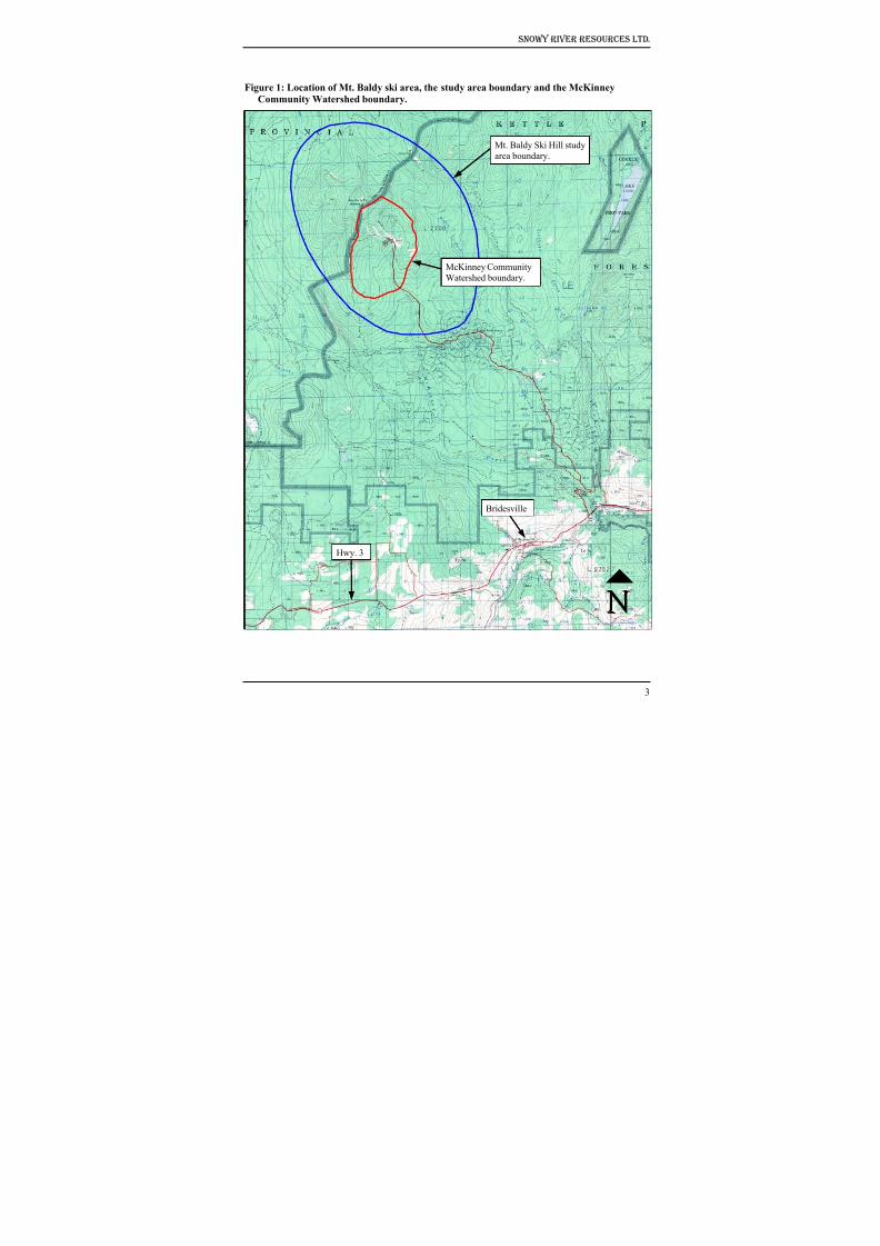
8/12/2019 Mount Baldy
http://slidepdf.com/reader/full/mount-baldy 208/322
Snowy River Resources Ltd.
Figure 1: Location of Mt. Baldy ski area, the study area boundary and the McKinney
Community Watershed boundary.
Hwy. 3
Bridesville
McKinney Community
Watershed boundary.
Mt. Baldy Ski Hill study
area boundary.
3
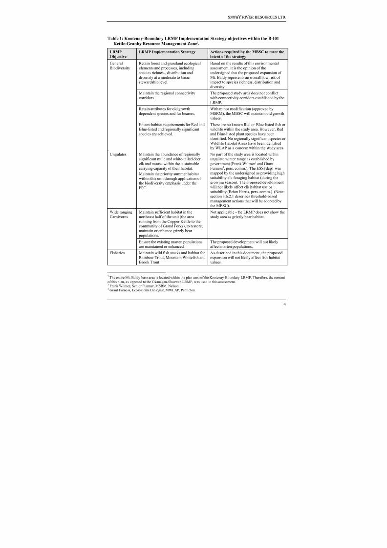
8/12/2019 Mount Baldy
http://slidepdf.com/reader/full/mount-baldy 209/322
Snowy River Resources Ltd.
Table 1: Kootenay-Boundary LRMP Implementation Strategy objectives within the B-I01
Kettle-Granby Resource Management Zone2.
LRMP
Objective
LRMP Implementation Strategy Actions required by the MBSC to meet the
intent of the strategy
GeneralBiodiversity
Retain forest and grassland ecologicalelements and processes, including
species richness, distribution and
diversity at a moderate to basicstewardship level.
Based on the results of this environmentalassessment, it is the opinion of the
undersigned that the proposed expansion of
Mt. Baldy represents an overall low risk ofimpact to species richness, distribution and
diversity.
Maintain the regional connectivity
corridors.
The proposed study area does not conflict
with connectivity corridors established by the
LRMP.
Retain attributes for old growth
dependent species and fur bearers.
With minor modification (approved by
MSRM), the MBSC will maintain old growth
values.
Ensure habitat requirements for Red andBlue-listed and regionally significant
species are achieved.
There are no known Red or Blue-listed fish orwildlife within the study area. However, Red
and Blue-listed plant species have been
identified. No regionally significant species orWildlife Habitat Areas have been identified
by WLAP as a concern within the study area.
Ungulates Maintain the abundance of regionally
significant mule and white-tailed deer,
elk and moose within the sustainablecarrying capacity of their habitat.
Maintain the priority summer habitat
within this unit through application ofthe biodiversity emphasis under the
FPC.
No part of the study area is located within
ungulate winter range as established by
government (Frank Wilmer 3 and GrantFurness4, pers. comm.). The ESSFdcp1 was
mapped by the undersigned as providing high
suitability elk foraging habitat (during thegrowing season). The proposed development
will not likely affect elk habitat use orsuitability (Brian Harris, pers. comm.). (Note:
section 3.6.2.1 describes threshold-based
management actions that will be adopted bythe MBSC).
Wide ranging
Carnivores
Maintain sufficient habitat in the
northeast half of the unit (the area
running from the Copper Kettle to thecommunity of Grand Forks), to restore,
maintain or enhance grizzly bear
populations.
Not applicable - the LRMP does not show the
study area as grizzly bear habitat.
Ensure the existing marten populations
are maintained or enhanced.
The proposed development will not likely
affect marten populations.Fisheries Maintain wild fish stocks and habitat for
Rainbow Trout, Mountain Whitefish and
Brook Trout
As described in this document, the proposed
expansion will not likely affect fish habitat
values.
2 The entire Mt. Baldy base area is located within the plan area of the Kootenay-Boundary LRMP. Therefore, the content
of this plan, as opposed to the Okanagan-Shuswap LRMP, was used in this assessment.3 Frank Wilmer, Senior Planner, MSRM, Nelson.4 Grant Furness, Ecosystems Biologist, MWLAP, Penticton.
4
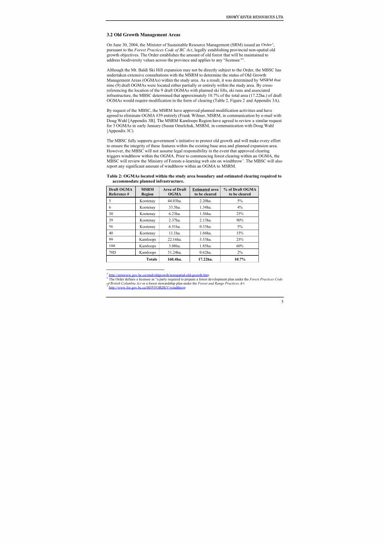
8/12/2019 Mount Baldy
http://slidepdf.com/reader/full/mount-baldy 210/322
Snowy River Resources Ltd.
3.2 Old Growth Management Areas
On June 30, 2004, the Minister of Sustainable Resource Management (SRM) issued an Order 5,
pursuant to the Forest Practices Code of BC Act , legally establishing provincial non-spatial old
growth objectives. The Order establishes the amount of old forest that will be maintained to
address biodiversity values across the province and applies to any “licensee6
”.
Although the Mt. Baldi Ski Hill expansion may not be directly subject to the Order, the MBSC has
undertaken extensive consultations with the MSRM to determine the status of Old Growth
Management Areas (OGMAs) within the study area. As a result, it was determined by MSRM that
nine (9) draft OGMAs were located either partially or entirely within the study area. By cross-
referencing the location of the 9 draft OGMAs with planned ski lifts, ski runs and associated
infrastructure, the MBSC determined that approximately 10.7% of the total area (17.22ha.) of draft
OGMAs would require modification in the form of clearing (Table 2, Figure 2 and Appendix 3A).
By request of the MBSC, the MSRM have approved planned modification activities and have
agreed to eliminate OGMA #39 entirely (Frank Wilmer, MSRM, in communication by e-mail with
Doug Wahl [Appendix 3B]. The MSRM Kamloops Region have agreed to review a similar requestfor 3 OGMAs in early January (Susan Omelchuk, MSRM, in communication with Doug Wahl
[Appendix 3C).
The MBSC fully supports government’s initiative to protect old growth and will make every effort
to ensure the integrity of these features within the existing base area and planned expansion area.
However, the MBSC will not assume legal responsibility in the event that approved clearing
triggers windthrow within the OGMA. Prior to commencing forest clearing within an OGMA, the
MBSC will review the Ministry of Forests e-learning web site on windthrow7. The MBSC will also
report any significant amount of windthrow within an OGMA to MSRM.
Table 2: OGMAs located within the study area boundary and estimated clearing required to
accommodate planned infrastructure.
Draft OGMA
Reference #
MSRM
Region
Area of Draft
OGMA
Estimated area
to be cleared
% of Draft OGMA
to be cleared
5 Kootenay 44.03ha. 2.20ha. 5%
6 Kootenay 33.5ha. 1.34ha. 4%
30 Kootenay 6.23ha. 1.56ha. 25%
39 Kootenay 2.37ha. 2.13ha. 90%
56 Kootenay 6.51ha. 0.33ha. 5%
40 Kootenay 11.1ha. 1.66ha. 15%
99 Kamloops 22.16ha. 5.53ha. 25%
100 Kamloops 3.08ha. 1.85ha. 60%
78D Kamloops 31.24ha. 0.62ha. 2%
Totals 160.4ha. 17.22ha. 10.7%
5 http://srmwww.gov.bc.ca/rmd/oldgrowth/nonspatial-old-growth.htm.6 The Order defines a licensee as “a party required to prepare a forest development plan under the Forest Practices Codeof British Columbia Act or a forest stewardship plan under the Forest and Range Practices Act . 7 http://www.for.gov.bc.ca/HFP/FORDEV/windthrow
5
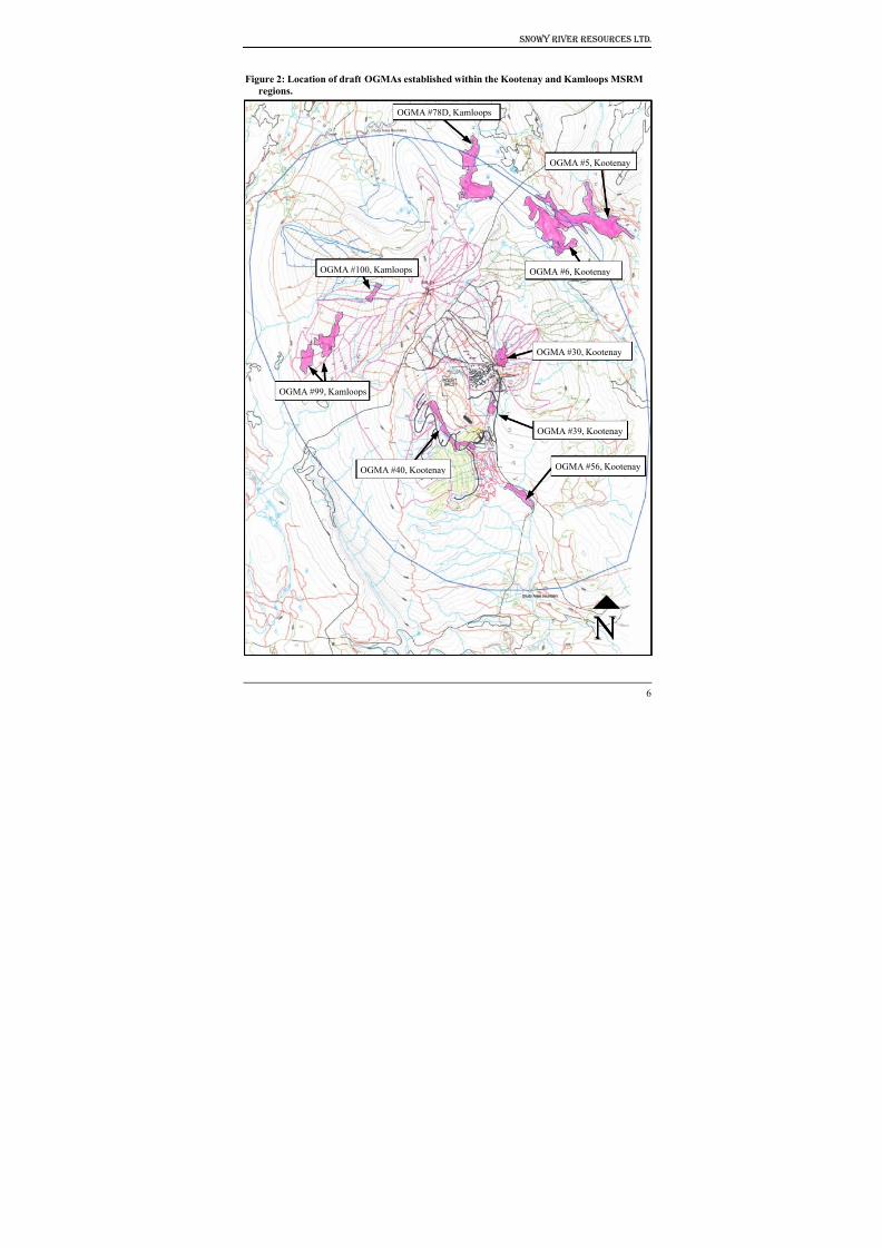
8/12/2019 Mount Baldy
http://slidepdf.com/reader/full/mount-baldy 211/322

8/12/2019 Mount Baldy
http://slidepdf.com/reader/full/mount-baldy 212/322
Snowy River Resources Ltd.
3.3 Wildlife Habitat Areas
Under the Forest and Range Practices Act and regulations, Species at Risk and Regionally
Important Wildlife can be declared by the Minister of MWLAP as Identified Wildlife. These
species can be managed through the establishment of wildlife habitat areas (WHA) as well as other
measures.
Wildlife Habitat Areas (WHAs) are mapped areas that are necessary to meet the habitat
requirements of an Identified Wildlife element. WHAs designate critical habitats in which activities
are managed to limit their impact on the Identified Wildlife element for which the area was
established8.
Within the Okanagan Region of MWLAP, which includes the entire study area boundary, manyWHAs have been approved or are currently proposed. However, there are no WHAs either
approved or proposed within the study area boundary (Grant Furness pers. comm.9).
3.4 Ungulate Winter Range
An Ungulate Winter Range (UWR) is legally established under the Forest Practices Code of BC
Act or the Forest and Range Practices Act , and is defined as an area that contains habitat that is
necessary to meet the winter habitat requirements of an ungulate species10.
The area encompassed by the study area boundary is not currently designated or planned for
designation as Ungulate Winter Range (Grant Furness and Frank Wilmer 11, pers. comm.).
3.5 Rare and Endangered Species
As part of this assessment, the British Columbia Conservation Data Center 12 (CDC) was consulted
to identify information on animals, plants and plant communities at risk (Red13 and Blue-listed14)
within the study area.
The CDC indicated that there are no recorded observations for Red or Blue-listed wildlife species
within or immediately adjacent to the study area, however, there were records of one Red-listed
vascular plant and two Blue-listed vascular plants. Based on a detailed assessment on the accuracy
of the record for the Red-listed vascular plant, we requested, and the CDC subsequently agreed,
that the record be removed entirely.
The report for the Red-listed vascular plant Ipomopsis minutiflora (Small-flowered Ipomopsis)
simply indicates that is was “last observed in 1961 on a dry bank beside road”. The source for this
record is a herbarium collection that simply reads “8 miles (12.8 km) east of Oliver”. This spatially
large polygon flanks the west side of the study area (refer to CDC Element Occurrence Record
5658). BEC subzone/variant mapping indicates that the study area lies in the ESSFdc1 and
MSdm1. However, in BC, this plant has only been observed at low to mid elevations in BG, IDF
8 MWLAP, 2004. Procedures for Managing Identified Wildlife. Available on-line at
http://wlapwww.gov.bc.ca/wld/documents/identified/IWMS%20Procedures.pdf 9 Grant Furness, Ecosystems Biologist, MWLAP, Penticton.10 http://wlapwww.gov.bc.ca/wld/uwr 11 Frank Wilmer, Senior Planner, MSRM, Nelson12 http://srmwww.gov.bc.ca/cdc/ 13 The CDC defines a Red-listed species as being endangered; facing imminent extirpation or extinction.14 A Blue-listed species as being vulnerable; particularly sensitive to human activities or natural events.
7
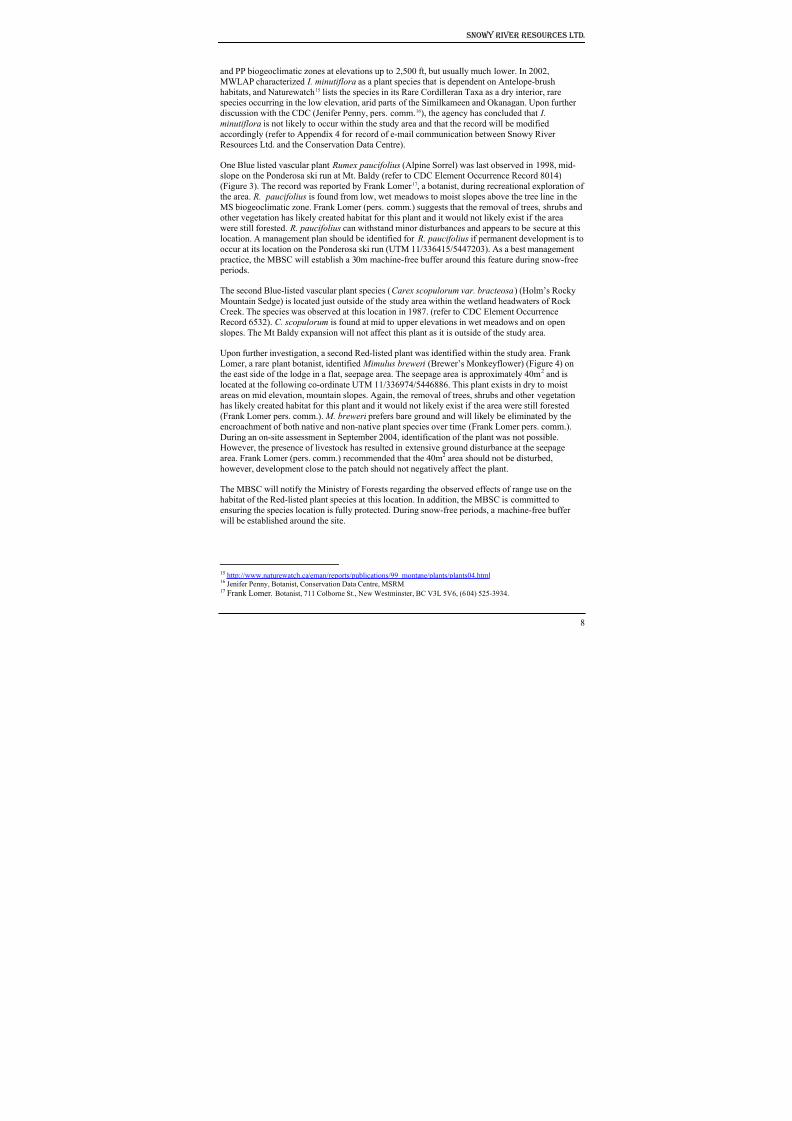
8/12/2019 Mount Baldy
http://slidepdf.com/reader/full/mount-baldy 213/322
Snowy River Resources Ltd.
and PP biogeoclimatic zones at elevations up to 2,500 ft, but usually much lower. In 2002,
MWLAP characterized I. minutiflora as a plant species that is dependent on Antelope-brush
habitats, and Naturewatch15 lists the species in its Rare Cordilleran Taxa as a dry interior, rare
species occurring in the low elevation, arid parts of the Similkameen and Okanagan. Upon further
discussion with the CDC (Jenifer Penny, pers. comm.16), the agency has concluded that I.
minutiflora is not likely to occur within the study area and that the record will be modifiedaccordingly (refer to Appendix 4 for record of e-mail communication between Snowy River
Resources Ltd. and the Conservation Data Centre).
One Blue listed vascular plant Rumex paucifolius (Alpine Sorrel) was last observed in 1998, mid-
slope on the Ponderosa ski run at Mt. Baldy (refer to CDC Element Occurrence Record 8014)
(Figure 3). The record was reported by Frank Lomer 17, a botanist, during recreational exploration of
the area. R. paucifolius is found from low, wet meadows to moist slopes above the tree line in the
MS biogeoclimatic zone. Frank Lomer (pers. comm.) suggests that the removal of trees, shrubs and
other vegetation has likely created habitat for this plant and it would not likely exist if the area
were still forested. R. paucifolius can withstand minor disturbances and appears to be secure at this
location. A management plan should be identified for R. paucifolius if permanent development is to
occur at its location on the Ponderosa ski run (UTM 11/336415/5447203). As a best management practice, the MBSC will establish a 30m machine-free buffer around this feature during snow-free
periods.
The second Blue-listed vascular plant species (Carex scopulorum var. bracteosa) (Holm’s Rocky
Mountain Sedge) is located just outside of the study area within the wetland headwaters of Rock
Creek. The species was observed at this location in 1987. (refer to CDC Element Occurrence
Record 6532). C. scopulorum is found at mid to upper elevations in wet meadows and on open
slopes. The Mt Baldy expansion will not affect this plant as it is outside of the study area.
Upon further investigation, a second Red-listed plant was identified within the study area. Frank
Lomer, a rare plant botanist, identified Mimulus breweri (Brewer’s Monkeyflower) (Figure 4) on
the east side of the lodge in a flat, seepage area. The seepage area is approximately 40m2 and is
located at the following co-ordinate UTM 11/336974/5446886. This plant exists in dry to moist
areas on mid elevation, mountain slopes. Again, the removal of trees, shrubs and other vegetation
has likely created habitat for this plant and it would not likely exist if the area were still forested
(Frank Lomer pers. comm.). M. breweri prefers bare ground and will likely be eliminated by the
encroachment of both native and non-native plant species over time (Frank Lomer pers. comm.).
During an on-site assessment in September 2004, identification of the plant was not possible.
However, the presence of livestock has resulted in extensive ground disturbance at the seepage
area. Frank Lomer (pers. comm.) recommended that the 40m2 area should not be disturbed,
however, development close to the patch should not negatively affect the plant.
The MBSC will notify the Ministry of Forests regarding the observed effects of range use on the
habitat of the Red-listed plant species at this location. In addition, the MBSC is committed to
ensuring the species location is fully protected. During snow-free periods, a machine-free bufferwill be established around the site.
15 http://www.naturewatch.ca/eman/reports/publications/99_montane/plants/plants04.html 16 Jenifer Penny, Botanist, Conservation Data Centre, MSRM.17 Frank Lomer, Botanist, 711 Colborne St., New Westminster, BC V3L 5V6, (604) 525-3934.
8
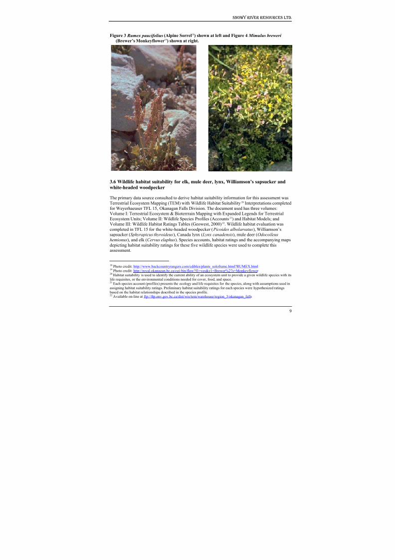
8/12/2019 Mount Baldy
http://slidepdf.com/reader/full/mount-baldy 214/322
Snowy River Resources Ltd.
Figure 3 Rumex paucifolius (Alpine Sorrel18) shown at left and Figure 4 Mimulus breweri (Brewer’s Monkeyflower19) shown at right.
3.6 Wildlife habitat suitability for elk, mule deer, lynx, Williamson’s sapsucker and
white-headed woodpecker
The primary data source consulted to derive habitat suitability information for this assessment was
Terrestrial Ecosystem Mapping (TEM) with Wildlife Habitat Suitability20 Interpretations completed
for Weyerhaeuser TFL 15, Okanagan Falls Division. The document used has three volumes:
Volume I: Terrestrial Ecosystem & Bioterrrain Mapping with Expanded Legends for Terrestrial
Ecosystem Units; Volume II: Wildlife Species Profiles (Accounts21) and Habitat Models; and
Volume III: Wildlife Habitat Ratings Tables (Geowest, 2000)22. Wildlife habitat evaluation was
completed in TFL 15 for the white-headed woodpecker ( Picoides albolarvatus), Williamson’s
sapsucker (Sphyrapicus thyroideus), Canada lynx ( Lynx canadensis), mule deer (Odocoileus
hemionus), and elk (Cervus elaphus). Species accounts, habitat ratings and the accompanying maps
depicting habitat suitability ratings for these five wildlife species were used to complete thisassessment.
18 Photo credit: http://www.backcountryrangers.com/edibles/plants_soloframe.html?RUMEX.html 19
Photo credit: http://royal.okanagan.bc.ca/cgi-bin/flow?f1=yes&c1=Brewer%27s+Monkeyflower 20 Habitat suitability is used to identify the current ability of an ecosystem unit to provide a given wildlife species with itslife requisites, or the environmental conditions needed for cover, food, and space.21 Each species account (profiles) presents the ecology and life requisites for the species, along with assumptions used in
assigning habitat suitability ratings. Preliminary habitat suitability ratings for each species were hypothesized ratings based on the habitat relationships described in the species profile.22 Available on-line at ftp://ftp.env.gov.bc.ca/dist/wis/tem/warehouse/region_3/okanagan_falls
9
8/12/2019 Mount Baldy
http://slidepdf.com/reader/full/mount-baldy 215/322
Snowy River Resources Ltd.
3.6.1 Methods
Wildlife interpretations were extrapolated to the unmapped portion of the proposed development
location using Biogeoclimatic Ecosystem Classification, TRIM, and forest cover mapping along
with aerial photographs. The methodology used to identify ecosystem units is similar to that for
TEM, with the exception that air photos are not pre-typed for bioterrain features and the site series
units were not ground truthed. Mapping is based on vegetation types rather than on bioterrain polygons.
Forest cover labels were used to determine structural stage and broad site series classifications.
There was no habitat or vegetation mapping available for the study area. Site series units in the
study area were identified using the Ministry of Forests field guide for the Kamloops Forest Region
(Lloyd et al. 1990).
Rating schemes are based on the level of knowledge of a species use of available. For species
where there is a high level of knowledge (e.g. for this project, elk and mule deer) a 6-class ratings
scheme is employed. For other species where there is a moderate level of knowledge (e.g. for this
project, lynx, white-headed woodpecker, and Williamson’s sapsucker), a 4-class ratings scheme
was used (Table 3).
Table 3: Habitat rating schemes used elk, mule deer, lynx, Williamson’s sapsucker and white-
headed woodpecker.
% of Provincial
Best
High Knowledge of Habitat Use
(6-class for elk & mule deer)
Moderate Knowledge of Habitat Use
(4-class for lynx, Williamson’s sapsucker
and white-headed woodpecker)
Rating Code Rating Code
100 - 76% High 1 High H
75 - 51% Moderately High 2
50 - 26% Moderate 3
Moderate M
25 - 6% Low 4
5 – 1% Very Low 5
Low L
0% Nil 6 Nil N
3.6.2 Results
The following sections summarize the results of TEM Wildlife Interpretations prepared for TFL 15
as well as surrogate mapping completed for portions of the study area where TEM had not been
completed.
3.6.2.1 Elk
Elk habitat suitability within and adjacent to the study area in the ESSFdc1 and ESSFdcu biogeoclimatic subzones, is generally rated as low for forage and security/thermal cover in the
winter, and moderate for both forage and security thermal cover during the growing seasons
(spring, summer and fall) (Table 4). The dry cold Engelmann Spruce Subalpine Fir (ESSFdc1)
biogeoclimatic subzone, occurs at an elevation of 1,600-1,800 m. Dominant vegetation consists ofmixed mature seral stands of lodgepole pine, Engelmann spruce and subalpine fir. Understorey is
dominated by grouseberry, Sitka valerian, five-leaved bramble and trapper’s tea. These plant
associations typically provide very limited elk foraging opportunities during the summer/fall and
snow depths restrict winter use.
10

8/12/2019 Mount Baldy
http://slidepdf.com/reader/full/mount-baldy 216/322
Snowy River Resources Ltd.
There is a small portion of alpine sedge, alpine fescue, and herbaceous meadow habitat found in
the upper elevation parkland variant of the ESSFdc1 (Polygon # 1, Figure 5). These habitats are
found at approximately 2,200m asl and have been rated high for elk foraging in all seasons
(Geowest 2000). Alpine sedge, alpine fescue and herbaceous meadow habitat types provide
excellent opportunities for elk feeding year round. However, it is unlikely that elk use this habitat
in winter months due to the high elevation and the distance to other suitable winter habitat in thearea. The species model for elk in TFL 15 (Geowest 2000) indicates that elk winter habitat is
restricted to elevations less than 1,400m. For this reason we have not mapped these habitat
associations as high for winter feeding suitability.
There are no known government records of elk use within the study area boundary (Orville Dyer
and Brian Harris pers. comm.23) and no elk have been sighted on or near Mt. Baldy by ski hill staff
(Tim Foster, pers. comm.24) The proposed development will not likely affect elk habitat use or
suitability (Brian Harris, pers. comm.). Nonetheless, the MBSC supports MWLAPs
recommendation (Brian Harris pers. comm.) that a Qualified Professional should assess elk habitat
use in the ESSFdcp1 once a threshold of >500 person days/month of use is exceeded during June-
October.
Table 4: Ecosystem units and structural stages rated at moderate, moderately high, and high
habitat suitability for elk within the study area.
BEC Ecosystem Unit Structural Stage Habitat Suitability Rating25
FH (Bl – Horsetail – Glow Moss) 5, 7 3FDG, 3STG, 3THGESSFdc1
SM (Sedge – Wet Meadow) 2b 3FDG
FH (BlPl – Juniper – Grouseberry) 5,6,7 3STG, 3THGESSFdcu
FV (Bl – Valerian) 5 3STG, 3THG, 3STW, 3THW
FV (Bl – Valerian – Pink Mountain
Heather
3 3FDG
SF (Sedge – Alpine fescue) 2b 1FDG, 1FDW (downgraded to
high suitability foraging for thegrowing season.
SR (Black alpine sedge – Rush) 2b 2FDG, 3FDW
ESSFdcp1
VG (Valerian – Globeflower
herbaceous meadow)
2b 2FDG, 3FDW
3 2FDG
4 3FDG
5 2FDG, 3STG, 3SHG
6 2FDG, 3STG, 3SHG
PP (Pl – Pinegrass – kinnikinnick)
7 2FDG, 3STG, 3SHG
MSdm1
SW (Sedge – wetlands) 2b 2FDG, 3STG, 3SHG
23 Orville Dyer and Brian Harris, Wildlife Biologists, MWLAP, Penticton.24 Tim Foster, General Manager, Mt. Baldy Ski Corporation25 FDG = Feeding in the growing seasons; FDW = Feeding in winter; STG = Security cover in the growing seasons; THG= thermal cover in the growing seasons; STW = Security cover in the winter; THW = Thermal cover in the winter .
11
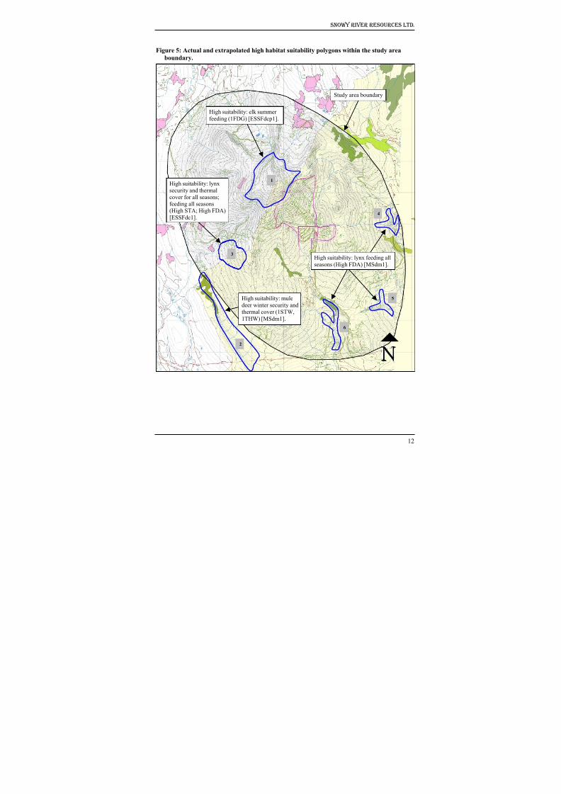
8/12/2019 Mount Baldy
http://slidepdf.com/reader/full/mount-baldy 217/322
Snowy River Resources Ltd.
Figure 5: Actual and extrapolated high habitat suitability polygons within the study area
boundary.
High suitability: mule
deer winter security and
thermal cover (1STW,
1THW) [MSdm1].
Study area boundary
High suitability: lynx
security and thermal
cover for all seasons;feeding all seasons
(High STA; High FDA)
[ESSFdc1].
6
5
3
1
4
2
High suitability: elk summer
feeding (1FDG) [ESSFdcp1].
High suitability: lynx feeding all
seasons (High FDA) [MSdm1].
12
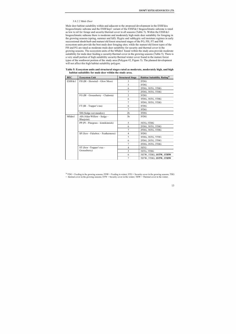
8/12/2019 Mount Baldy
http://slidepdf.com/reader/full/mount-baldy 218/322
Snowy River Resources Ltd.
3.6.2.2 Mule Deer
Mule deer habitat suitability within and adjacent to the proposed development in the ESSFdcu
biogeoclimatic subzone and the ESSFdcp1 variant of the ESSFdc1 biogeoclimatic subzone is rated
as low to nil for forage and security/thermal cover in all seasons (Table 5). Within the ESSFdc1
biogeoclimatic subzone there is moderate and moderately high mule deer suitability for foraging in
the growing seasons (spring, summer and fall). Hygric and subhygric soil moisture regimes in earlysuccessional shrub/herb and mature/old forest structural stages of the FG, FH, FT and SM
ecosystem units provide the best mule deer foraging sites; while the mature/old forest types of the
FH and FG are rated as moderate mule deer suitability for security and thermal cover in the
growing seasons. The ecosystem units of the MSdm1 found within the study area provide moderate
suitability for mule deer feeding a security/thermal cover in the growing seasons (Table 5). There is
a very small portion of high suitability security/thermal winter cover found in the mature forest
types of the southwest portion of the study area (Polygon #2, Figure 5). The planned development
will not affect this high habitat suitability polygon.
Table 5: Ecosystem units and structural stages rated as moderate, moderately high, and high
habitat suitability for mule deer within the study area.
BEC Ecosystem Unit Structural Stage Habitat Suitability Rating26
3 2FDG
5 3FDG
6 2FDG, 3STG, 3THG
FH (Bl – Horsetail – Glow Moss)
7 2FDG, 3STG, 3THG
3 3FDG
6 3FDG, 3STG, 3THG
FG (Bl – Grouseberry – Cladonia)
7 3FDG, 3STG, 3THG
6 3FDGFT (Bl – Trapper’s tea)
7 3FDG
ESSFdc1
SM (Sedge wet meadow) 2b 3FDGAB (Alder/Willow – Sedge –
Bluejoint)
3b 3FDG
5 3STG, 3THG
6 2FDG, 3STG, 3THG
PP (Pl – Pinegrass – kinnikinnick)
7 2FDG, 3STG, 3THG
4 3FDG
5 3FDG, 3STG, 3THG
6 2FDG, 2STG, 2THG
SF (Sxw – Falsebox – Feathermoss)
7 2FDG, 2STG, 2THG
4 3STG
5 3STG, 3THG6 3STW, 3THG, 1STW, 1THW
MSdm1
ST (Sxw –Trapper’s tea –
Grouseberry)
7 3STW, 3THG, 1STW, 1THW
26 FDG = Feeding in the growing seasons; FDW = Feeding in winter; STG = Security cover in the growing seasons; THG= thermal cover in the growing seasons; STW = Security cover in the winter; THW = Thermal cover in the winter .
13
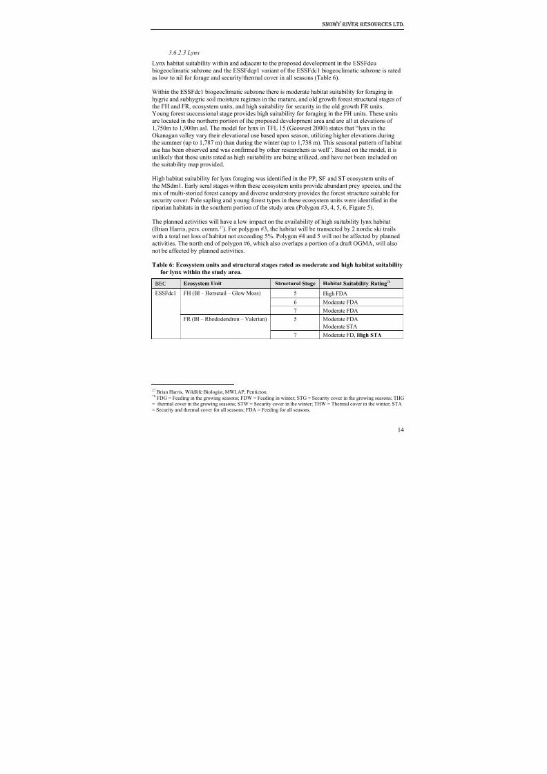
8/12/2019 Mount Baldy
http://slidepdf.com/reader/full/mount-baldy 219/322
Snowy River Resources Ltd.
3.6.2.3 Lynx
Lynx habitat suitability within and adjacent to the proposed development in the ESSFdcu
biogeoclimatic subzone and the ESSFdcp1 variant of the ESSFdc1 biogeoclimatic subzone is rated
as low to nil for forage and security/thermal cover in all seasons (Table 6).
Within the ESSFdc1 biogeoclimatic subzone there is moderate habitat suitability for foraging in
hygric and subhygric soil moisture regimes in the mature, and old growth forest structural stages of
the FH and FR, ecosystem units, and high suitability for security in the old growth FR units.
Young forest successional stage provides high suitability for foraging in the FH units. These units
are located in the northern portion of the proposed development area and are all at elevations of
1,750m to 1,900m asl. The model for lynx in TFL 15 (Geowest 2000) states that “lynx in the
Okanagan valley vary their elevational use based upon season, utilizing higher elevations during
the summer (up to 1,787 m) than during the winter (up to 1,738 m). This seasonal pattern of habitat
use has been observed and was confirmed by other researchers as well”. Based on the model, it is
unlikely that these units rated as high suitability are being utilized, and have not been included on
the suitability map provided.
High habitat suitability for lynx foraging was identified in the PP, SF and ST ecosystem units of
the MSdm1. Early seral stages within these ecosystem units provide abundant prey species, and the
mix of multi-storied forest canopy and diverse understory provides the forest structure suitable for
security cover. Pole sapling and young forest types in these ecosystem units were identified in the
riparian habitats in the southern portion of the study area (Polygon #3, 4, 5, 6, Figure 5).
The planned activities will have a low impact on the availability of high suitability lynx habitat
(Brian Harris, pers. comm.27). For polygon #3, the habitat will be transected by 2 nordic ski trails
with a total net loss of habitat not exceeding 5%. Polygon #4 and 5 will not be affected by planned
activities. The north end of polygon #6, which also overlaps a portion of a draft OGMA, will also
not be affected by planned activities.
Table 6: Ecosystem units and structural stages rated as moderate and high habitat suitabilityfor lynx within the study area.
BEC Ecosystem Unit Structural Stage Habitat Suitability Rating28
5 High FDA
6 Moderate FDA
FH (Bl – Horsetail – Glow Moss)
7 Moderate FDA
5 Moderate FDA
Moderate STA
ESSFdc1
FR (Bl – Rhododendron – Valerian)
7 Moderate FD, High STA
27 Brian Harris, Wildlife Biologist, MWLAP, Penticton.28 FDG = Feeding in the growing seasons; FDW = Feeding in winter; STG = Security cover in the growing seasons; THG= thermal cover in the growing seasons; STW = Security cover in the winter; THW = Thermal cover in the winter; STA= Security and thermal cover for all seasons; FDA = Feeding for all seasons.
14
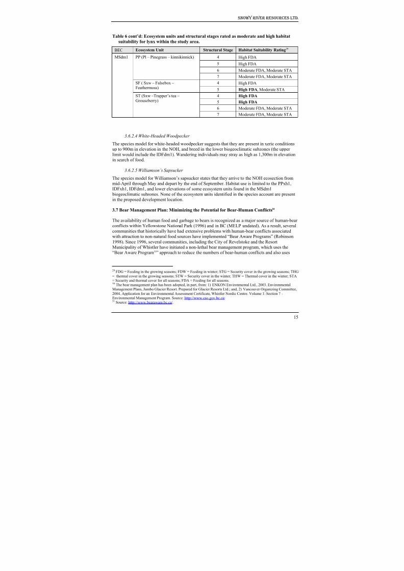
8/12/2019 Mount Baldy
http://slidepdf.com/reader/full/mount-baldy 220/322
Snowy River Resources Ltd.
Table 6 cont’d: Ecosystem units and structural stages rated as moderate and high habitat
suitability for lynx within the study area.
BEC Ecosystem Unit Structural Stage Habitat Suitability Rating29
4 High FDA
5 High FDA6 Moderate FDA, Moderate STA
PP (Pl – Pinegrass – kinnikinnick)
7 Moderate FDA, Moderate STA
4 High FDASF ( Sxw – Falsebox –Feathermoss) 5 High FDA, Moderate STA
4 High FDA
5 High FDA
6 Moderate FDA, Moderate STA
MSdm1
ST (Sxw –Trapper’s tea –Grouseberry)
7 Moderate FDA, Moderate STA
3.6.2.4 White-Headed Woodpecker
The species model for white-headed woodpecker suggests that they are present in xeric conditions
up to 900m in elevation in the NOH, and breed in the lower biogeoclimatic subzones (the upper
limit would include the IDFdm1). Wandering individuals may stray as high as 1,300m in elevationin search of food.
3.6.2.5 Williamson’s Sapsucker
The species model for Williamson’s sapsucker states that they arrive to the NOH ecosection from
mid-April through May and depart by the end of September. Habitat use is limited to the PPxh1,
IDFxh1, IDFdm1, and lower elevations of some ecosystem units found in the MSdm1
biogeoclimatic subzones. None of the ecosystem units identified in the species account are presentin the proposed development location.
3.7 Bear Management Plan: Minimizing the Potential for Bear-Human Conflicts30
The availability of human food and garbage to bears is recognized as a major source of human-bear
conflicts within Yellowstone National Park (1996) and in BC (MELP undated). As a result, several
communities that historically have had extensive problems with human-bear conflicts associated
with attraction to non-natural food sources have implemented “Bear Aware Programs” (Robinson
1998). Since 1996, several communities, including the City of Revelstoke and the Resort
Municipality of Whistler have initiated a non-lethal bear management program, which uses the
“Bear Aware Program31” approach to reduce the numbers of bear-human conflicts and also uses
29 FDG = Feeding in the growing seasons; FDW = Feeding in winter; STG = Security cover in the growing seasons; THG
= thermal cover in the growing seasons; STW = Security cover in the winter; THW = Thermal cover in the winter; STA= Security and thermal cover for all seasons; FDA = Feeding for all seasons.30 The bear management plan has been adopted, in part, from: 1) ENKON Environmental Ltd., 2003. EnvironmentalManagement Plans, Jumbo Glacier Resort. Prepared for Glacier Resorts Ltd.; and, 2) Vancouver Organizing Committee,
2004. Application for an Environmental Assessment Certificate, Whistler Nordic Centre. Volume 1: Section 7 -Environmental Management Program. Source: http://www.eao.gov.bc.ca/.31 Source: http://www.bearaware.bc.ca/.
15
8/12/2019 Mount Baldy
http://slidepdf.com/reader/full/mount-baldy 221/322
Snowy River Resources Ltd.
deterrents to correct “problem” bear behaviour without destroying the animals. While the program
is still in its infancy, the number of bears destroyed or relocated has dropped dramatically
Over the past 5 years, there have been no incidents of bear-human conflicts at the Mt. Baldy ski hill
(Leslie Cook 32, Bob Hamilton33 & Tim Foster 34, pers. comm.). Despite the absence of recorded
bear-human conflicts, there is an ideal opportunity to initiate a “Bear Aware Program” to minimizethe potential for bear-human conflicts to occur. As part of the expansion project, the Mt. Baldy Ski
Corporation will seek the assistance and cooperation of the Regional District of Kootenay
Boundary with the goal of adopting its own “Bear Aware Program”. The program will have the
following objectives:
1. Reduce or eliminate bear deaths and relocations as a result of bears being attracted into the
village by garbage, fruit, compost and other human-generated attractants. Ultimately the
reduction/elimination of bear deaths would ensure that births exceed deaths;
2. Increase the public’s understanding of the negative implications to bears and humans when bears
forage in urban areas;
3. Build public support for the objectives of these programs (Robinson 1998); and
The details of the program outlined below will form part of the long-term management plan and
will be considered as bylaws by the Mt. Baldy Ski Corporation and, where in agreement, the
Regional District of Kootenay Boundary. The “Bear Aware Program” for the Mt. Baldy Ski Hill
may include the following mitigation measures:
1. All outdoor trash cans and dumpsters will be of a bear resistant design, and all trash cans will
have plastic removable liners to contain odors as much as possible. Plastic can liners will be
changed at every pickup to eliminate any odor. Maintenance personnel will ensure that the bear-
proof trash cans are available where needed.
2. Public areas will be maintained as litter-free as possible within the limits of available staff and budgets.
3. Drive-through inspections for garbage will be performed on a regular basis to determine whether
there are any open containers and/or garbage.
4. Garbage pick-up will be carefully scheduled (preferably later in the day) to assure leaving as
little garbage as possible overnight to allow for odor to emanate. If possible, garbage pick-up will
be centralized, meaning that single family residences will be required to drop garbage in local bear-
proof containers.
5. All bear-proof containers will be picked up as quickly as possible to minimize the build up of
any odors or spillage.
6. Landscaping and maintenance for the Mt. Baldi Ski Hill will avoid the use of fruit trees, compost
and other bear attractants.
32 Enforcement Clerk, Conservation Officer Service, MWLAP, Penticton.33 Conservation Officer, MWLAP, Penticton.34 Site Manager, Mt. Baldy Ski Corporation
16
8/12/2019 Mount Baldy
http://slidepdf.com/reader/full/mount-baldy 222/322
Snowy River Resources Ltd.
7. Facility personnel will identify and correct operational and maintenance deficiencies regularly
on an on going basis. Inspections will be conducted all year round and comply with regional
standards.
8. All long term commercial operators will be given food and garbage management guidelines.
9. Any garbage transfer or detainment areas will be fenced with bear-resistant fencing or electric
fencing. These fences will be repaired and maintained as needed within the limits of available staff
and budgets.
10. If garbage is to be burned on-site, all combustible garbage will be burned in enclosed
incinerators. No garbage, including empty cans or other food containers, will be buried; and
11. Odor control from sewage facilities will require a demanding management approach. Sewage
lagoons, if any, will be fenced with bear resistant fencing or electric fencing. These fences will be
repaired and maintained as needed.
3.8 Water Quality
3.8.1 McKinney Community Watershed
The upper reaches of McKinney Creek are designated as a Community Watershed35 (Figure 6).
While there are currently no legal water quality objectives that apply to a Community Watershed,
there are specific requirements related to the conduct of forest and range practices that apply to
forest and range tenure holders36 subject to the Forest Practices Code of BC Act or the Forest and
Range Practices Act . With regard to the protection of fish habitat and water quality, theserequirements and best practices are identified in the Operational and Site Planning Regulation, the
Forest Planning and Practices Regulation37 and the Community Watershed Guidebook 38.
The MBSC fully intends on continuing it’s contribution to the maintenance of water quality and
downstream fish habitat by adopting minimum reserve and management zone widths for S2-S4
streams (Table 7) as prescribed in the Operational and Site Planning Regulation, the Forest
Planning and Practices Regulation. This initiative will apply not only to areas within the
McKinney Community Watershed, but to all streams39 within the study area boundary. Similar to
the aforementioned Regulations, the reserve and management zone widths do not preclude the
removal of trees within the Riparian Management Area for the purposes of constructing roads,
trails/runs or ski lifts.
35 Reference # 320.012. Source: http://srmwww.gov.bc.ca/wat/cws/query/cws.htm 36 The Mt. Baldy Ski Corporation is not a forest or range tenure holder.37 http://www.for.gov.bc.ca/tasb/legsregs/archive/fpc/fpcaregs/oplanreg/opr.htm 38 http://www.for.gov.bc.ca/tasb/legsregs/fpc/FPCGUIDE/WATRSHED/Watertoc.htm.39 Applies to streams as defined by the Operational and Site Planning Regulation or the Forest Planning and Practices
Regulation.
17
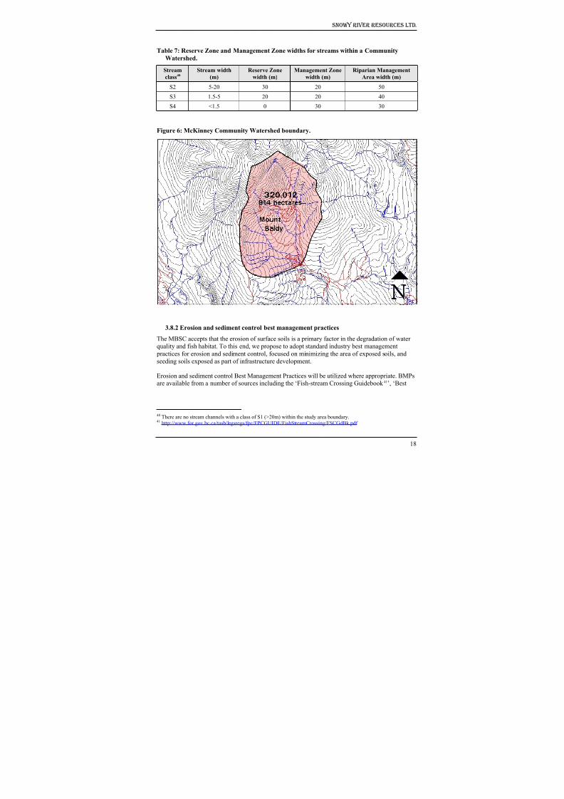
8/12/2019 Mount Baldy
http://slidepdf.com/reader/full/mount-baldy 223/322
Snowy River Resources Ltd.
Table 7: Reserve Zone and Management Zone widths for streams within a Community
Watershed.
Stream
class40
Stream width
(m)
Reserve Zone
width (m)
Management Zone
width (m)
Riparian Management
Area width (m)
S2 5-20 30 20 50
S3 1.5-5 20 20 40
S4 <1.5 0 30 30
Figure 6: McKinney Community Watershed boundary.
3.8.2 Erosion and sediment control best management practices
The MBSC accepts that the erosion of surface soils is a primary factor in the degradation of water
quality and fish habitat. To this end, we propose to adopt standard industry best management
practices for erosion and sediment control, focused on minimizing the area of exposed soils, and
seeding soils exposed as part of infrastructure development.
Erosion and sediment control Best Management Practices will be utilized where appropriate. BMPsare available from a number of sources including the ‘Fish-stream Crossing Guidebook 41’, ‘Best
18
40 There are no stream channels with a class of S1 (>20m) within the study area boundary.41 http://www.for.gov.bc.ca/tasb/legsregs/fpc/FPCGUIDE/FishStreamCrossing/FSCGdBk.pdf
8/12/2019 Mount Baldy
http://slidepdf.com/reader/full/mount-baldy 224/322
Snowy River Resources Ltd.
Management Practices Handbook: Hillslope Restoration in British Columbia42’, as well as
resources available from the International Erosion Control Association website43.
3.9 Riparian and Fish Habitat
3.9.1 Status of fish distributions within the study area
3.9.1.1 Methods
The location, type and quality of fish habitat is an essential component of applying appropriate
riparian management area strategies as well as providing fish passage at stream crossings.
As part of this assessment, a review of available fish and fish habitat information was undertaken
and supplemented with field assessments where existing information was lacking or incomplete.
The review of existing fish and fish habitat information included: 1) fish presence/absence surveys
completed by the forest licencee (Weyerhaeuser Company Ltd.); 2) data available on the Fish
Inventory Summary System; and 3) surveys completed as part of the environmental assessment for
the Southern Crossing Project (BC Gas). Where data was lacking or incomplete, field assessments
to assess fish and fish habitat were undertaken using methodology described in the ReconnaissanceFish and Fish Habitat Inventory Manual44 and the Fish-stream Identification Guidebook 45.
3.9.1.2 Results
Figure 7 shows the known distribution of fish within the study area. Fish absence has been
confirmed on all streams within the study area with the exception of two: 1) the upper reaches of
McIntyre Creek; and 2) the upper reaches of Wapiti Creek. For the upper reaches of Wapiti Creek,
however, the stream is shown as an assumed non fish-stream. Based on a previous fisheries
assessment (SSS 2002) the poor quality of fish habitat is likely to be a limiting factor to fish
distribution.
Prior to undertaking this assessment, there was no existing fish inventory information for
McKinney Creek with the exception of a combined electrofishing and minnow trapping surveyconducted by the Westland Resource Group (WRG) as part of the BC Gas Southern Crossing
Project. The survey site was located just upstream of the 15m high falls located by Snowy River
Resources Ltd. Although no fish were captured by WRG, the report does not provide a rationale for
the non fish-bearing status that they recommended.
As part of this project, Snowy River Resources Ltd. undertook a fish inventory of McKinney
Creek. As a result, a 15m high bedrock falls was identified as the upstream limit of fish. Rainbow
trout and eastern brook trout were captured downstream of the falls. However, no fish were
captured upstream of the falls during an electrofishing survey at 3 sites with a total of 600m of
stream sampled (Figure 8). The 15m high falls, as well as the electrofishing survey conducted
upstream of the falls, provide sufficient rationale to confirm that all watercourses upstream of the
falls are confirmed non fish-streams.
42 http://www.for.gov.bc.ca/hfd/pubs/Docs/Mr/Mr096.htm 43 http://www.ieca.org 44 Source: http://srmwww.gov.bc.ca/risc/pubs/aquatic/recon/index.htm 45 Source: http://www.for.gov.bc.ca/tasb/legsregs/fpc/FPCGUIDE/FishStreamCrossing/FSCGdBk.pdf
19
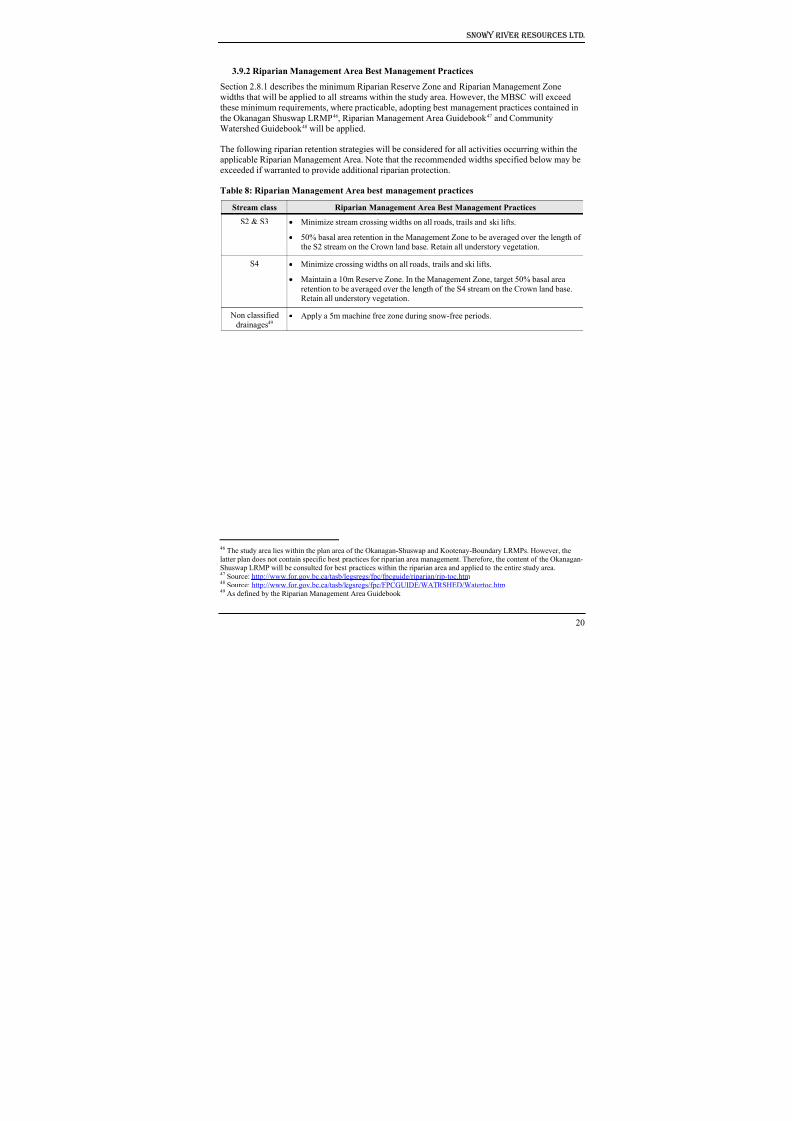
8/12/2019 Mount Baldy
http://slidepdf.com/reader/full/mount-baldy 225/322
Snowy River Resources Ltd.
3.9.2 Riparian Management Area Best Management Practices
Section 2.8.1 describes the minimum Riparian Reserve Zone and Riparian Management Zone
widths that will be applied to all streams within the study area. However, the MBSC will exceed
these minimum requirements, where practicable, adopting best management practices contained in
the Okanagan Shuswap LRMP46, Riparian Management Area Guidebook 47 and Community
Watershed Guidebook 48 will be applied.
The following riparian retention strategies will be considered for all activities occurring within the
applicable Riparian Management Area. Note that the recommended widths specified below may be
exceeded if warranted to provide additional riparian protection.
Table 8: Riparian Management Area best management practices
Stream class Riparian Management Area Best Management Practices
S2 & S3 • Minimize stream crossing widths on all roads, trails and ski lifts.
• 50% basal area retention in the Management Zone to be averaged over the length ofthe S2 stream on the Crown land base. Retain all understory vegetation.
S4 • Minimize crossing widths on all roads, trails and ski lifts.
• Maintain a 10m Reserve Zone. In the Management Zone, target 50% basal area
retention to be averaged over the length of the S4 stream on the Crown land base.Retain all understory vegetation.
Non classified
drainages49 • Apply a 5m machine free zone during snow-free periods.
46 The study area lies within the plan area of the Okanagan-Shuswap and Kootenay-Boundary LRMPs. However, thelatter plan does not contain specific best practices for riparian area management. Therefore, the content of the Okanagan-Shuswap LRMP will be consulted for best practices within the riparian area and applied to the entire study area.47 Source: http://www.for.gov.bc.ca/tasb/legsregs/fpc/fpcguide/riparian/rip-toc.htm 48 Source: http://www.for.gov.bc.ca/tasb/legsregs/fpc/FPCGUIDE/WATRSHED/Watertoc.htm 49 As defined by the Riparian Management Area Guidebook
20
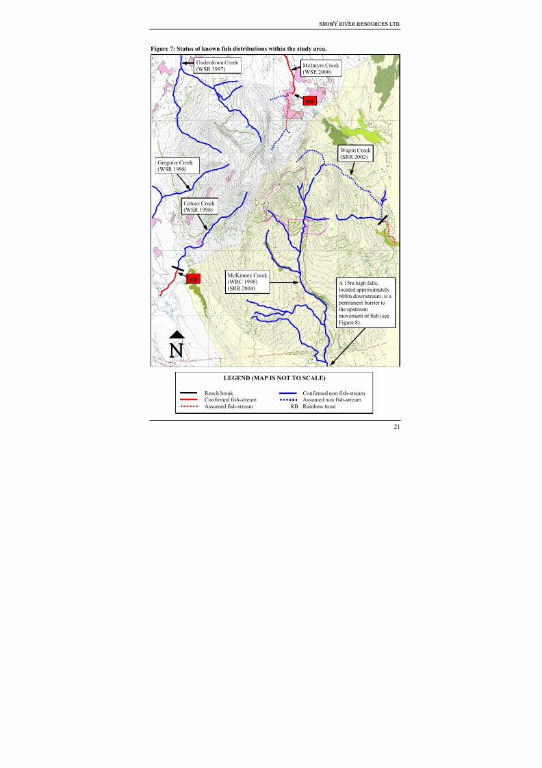
8/12/2019 Mount Baldy
http://slidepdf.com/reader/full/mount-baldy 226/322
Snowy River Resources Ltd.
Figure 7: Status of known fish distributions within the study area.
Figure 8).
RB
Underdown Creek
(WSR 1997)McIntyre Creek(WSE 2000)
Gregoire Creek
(WSR 1998)
Coteay Creek
(WSR 1998)
RBMcKinney Creek
(WRC 1998)
(SRR 2004)A 15m high falls,located approximately
600m downstream, is a permanent barrier to
the upstream
movement of fish (see
Wapiti Creek(SRR 2002)
LEGEND (MAP IS NOT TO SCALE)
Reach break Confirmed non fish-streamConfirmed fish-stream Assumed non fish-stream
Assumed fish-stream RB Rainbow trout
21
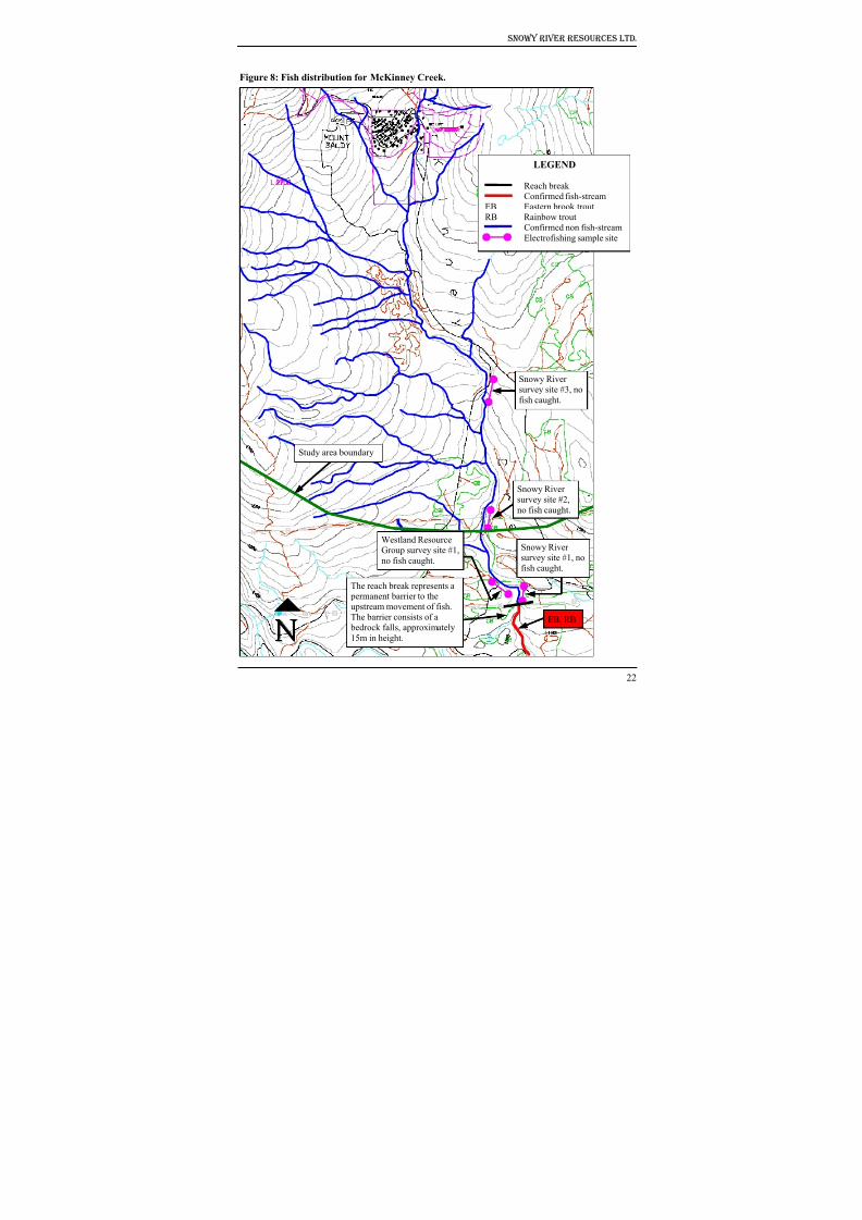
8/12/2019 Mount Baldy
http://slidepdf.com/reader/full/mount-baldy 227/322
Snowy River Resources Ltd.
Figure 8: Fish distribution for McKinney Creek.
22
LEGEND
Reach break
Confirmed fish-streamEB Eastern brook trout
RB Rainbow trout
Confirmed non fish-stream
Electrofishing sample site
Snowy River
survey site #3, no
fish caught.
Study area boundary
Snowy River
survey site #2,
no fish caught.
Westland Resource
Group survey site #1,no fish caught.
Snowy River
survey site #1, no
fish caught.
The reach break represents a
permanent barrier to the
upstream movement of fish.
The barrier consists of a
bedrock falls, approximately
15m in height.
EB, RB
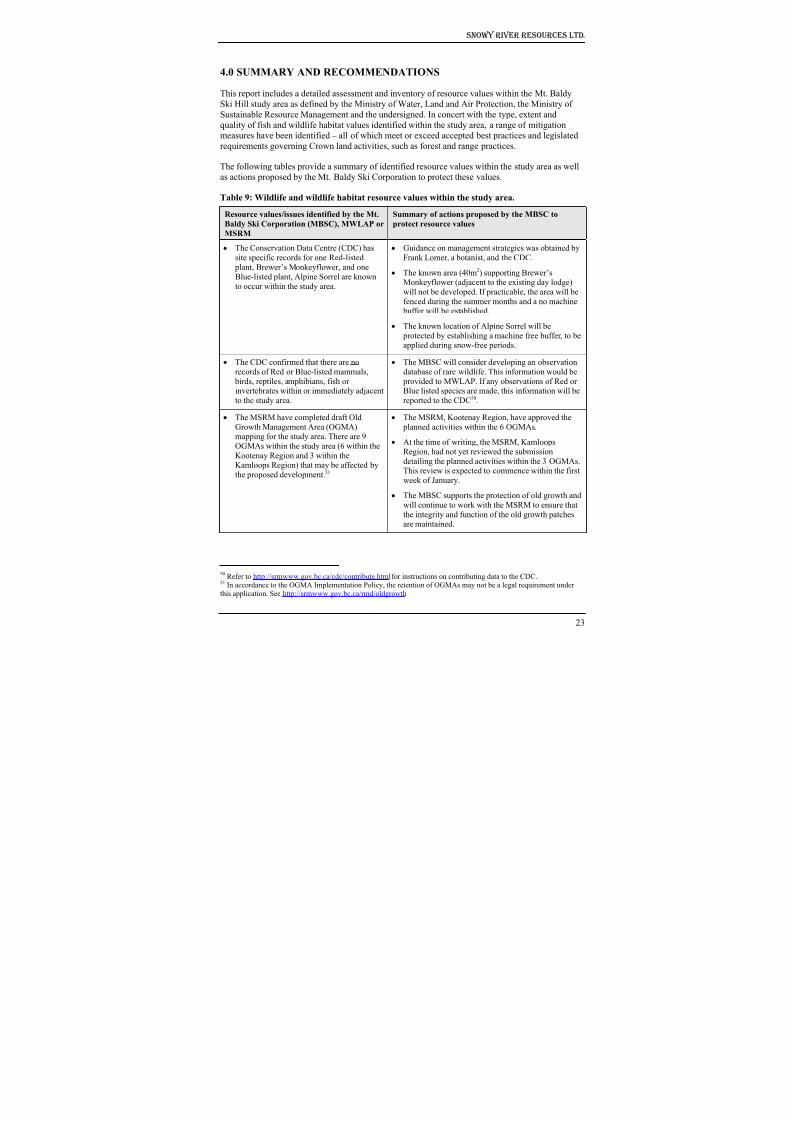
8/12/2019 Mount Baldy
http://slidepdf.com/reader/full/mount-baldy 228/322
Snowy River Resources Ltd.
4.0 SUMMARY AND RECOMMENDATIONS
This report includes a detailed assessment and inventory of resource values within the Mt. Baldy
Ski Hill study area as defined by the Ministry of Water, Land and Air Protection, the Ministry of
Sustainable Resource Management and the undersigned. In concert with the type, extent and
quality of fish and wildlife habitat values identified within the study area, a range of mitigationmeasures have been identified – all of which meet or exceed accepted best practices and legislated
requirements governing Crown land activities, such as forest and range practices.
The following tables provide a summary of identified resource values within the study area as well
as actions proposed by the Mt. Baldy Ski Corporation to protect these values.
Table 9: Wildlife and wildlife habitat resource values within the study area.
Resource values/issues identified by the Mt.
Baldy Ski Corporation (MBSC), MWLAP or
MSRM
Summary of actions proposed by the MBSC to
protect resource values
• The Conservation Data Centre (CDC) has
site specific records for one Red-listed
plant, Brewer’s Monkeyflower, and one
Blue-listed plant, Alpine Sorrel are known
to occur within the study area.
• Guidance on management strategies was obtained by
Frank Lomer, a botanist, and the CDC.
• The known area (40m2) supporting Brewer’sMonkeyflower (adjacent to the existing day lodge)
will not be developed. If practicable, the area will be
fenced during the summer months and a no machine buffer will be established.
• The known location of Alpine Sorrel will be
protected by establishing a machine free buffer, to beapplied during snow-free periods.
• The CDC confirmed that there are no
records of Red or Blue-listed mammals,
birds, reptiles, amphibians, fish orinvertebrates within or immediately adjacent
to the study area.
• The MBSC will consider developing an observation
database of rare wildlife. This information would be
provided to MWLAP. If any observations of Red orBlue listed species are made, this information will be
reported to the CDC50.
• The MSRM have completed draft Old
Growth Management Area (OGMA)mapping for the study area. There are 9
OGMAs within the study area (6 within the
Kootenay Region and 3 within theKamloops Region) that may be affected by
the proposed development.51
• The MSRM, Kootenay Region, have approved the
planned activities within the 6 OGMAs.
• At the time of writing, the MSRM, Kamloops
Region, had not yet reviewed the submission
detailing the planned activities within the 3 OGMAs.This review is expected to commence within the first
week of January.
• The MBSC supports the protection of old growth and
will continue to work with the MSRM to ensure thatthe integrity and function of the old growth patchesare maintained.
50 Refer to http://srmwww.gov.bc.ca/cdc/contribute.html for instructions on contributing data to the CDC.51 In accordance to the OGMA Implementation Policy, the retention of OGMAs may not be a legal requirement underthis application. See http://srmwww.gov.bc.ca/rmd/oldgrowth
23
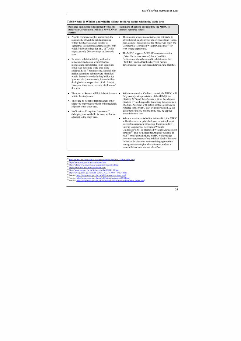
8/12/2019 Mount Baldy
http://slidepdf.com/reader/full/mount-baldy 229/322
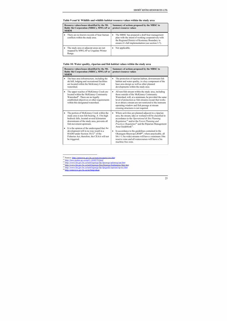
8/12/2019 Mount Baldy
http://slidepdf.com/reader/full/mount-baldy 230/322
Snowy River Resources Ltd.
Table 9 cont’d: Wildlife and wildlife habitat resource values within the study area
Resource values/issues identified by the Mt.
Baldy Ski Corporation (MBSC), MWLAP or
MSRM
Summary of actions proposed by the MBSC to
protect resource values
• There are no known records of bear-humanconflicts within the study area.
• The MBSC has prepared a draft bear management plan with the intent of working cooperatively with
the Regional District of Kootenay Boundary to
ensure it’s full implementation (see section 3.7).
• The study area or adjacent areas are not
mapped by MWLAP as Ungulate Winter
Range.
• Not applicable.
Table 10: Water quality, riparian and fish habitat values within the study area
Resource values/issues identified by the Mt.
Baldy Ski Corporation (MBSC), MWLAP orMSRM
Summary of actions proposed by the MBSC to
protect resource values
• The base area infrastructure, including the
ski hill, lodging and recreational facilities
are located within the McKinney Creekwatershed.
• The protection of riparian habitat, downstream fish
habitat and water quality, is a key component of the
base area design as well as other planneddevelopments within the study area.
• The upper reaches of McKinney Creek are
located within the McKinney Community
Watershed61. There are no legallyestablished objectives or other requirements
within this designated watershed.
• All non fish-stream within the study area, including
those outside of the McKinney Community
Watershed, will, at a minimum, be provided the samelevel of protection as fish-streams except that works
in or about a stream are not restricted to the instream
operating window and fish passage at stream
crossing structures is not required.
• The portion of McKinney Creek within thestudy area is non fish bearing. A 15m high
bedrock falls, located several kilometers
downstream of the study area, prevents all
fish movement upstream.
• It is the opinion of the undersigned that the
development will in no way result in aHADD under Section 35(1)62 of the
Fisheries Act, therefore, the CEAA will not
be triggered.
• Where activities are planned adjacent to a riparianarea, the stream, lake or wetland will be classified in
accordance to the Operational & Site Planning
Regulation 63 and/or the Forest Planning and
Practices Regulation64 and the Riparian ManagementArea Guidebook 65.
• In accordance to the guidelines contained in theOkanagan-Shuswap LRMP66, where practicable, all
S4 (<1.5m wide) streams will have a minimum 10m
reserve zone and all watercourses will have a 5mmachine free zone.
61 Source: http://srmwww.gov.bc.ca/wat/cws/query/cws.htm 62 http://laws.justice.gc.ca/en/F-14/60370.html 63 http://www.for.gov.bc.ca/tasb/legsregs/fpc/fpcaregs/oplanreg/opr.htm 64 http://www.for.gov.bc.ca/tasb/legsregs/frpa/frparegs/forplanprac/fppr.htm 65 http://www.for.gov.bc.ca/tasb/legsregs/fpc/fpcguide/riparian/rip-toc.htm 66 http://srmwww.gov.bc.ca/sir/lrmp/okan/
25
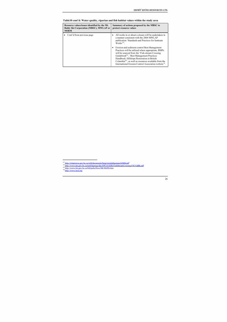
8/12/2019 Mount Baldy
http://slidepdf.com/reader/full/mount-baldy 231/322
Snowy River Resources Ltd.
Table10 cont’d: Water quality, riparian and fish habitat values within the study area
Resource values/issues identified by the Mt.
Baldy Ski Corporation (MBSC), MWLAP or
MSRM
Summary of actions proposed by the MBSC to
protect resource values
• Cont’d from previous page • All works in or about a stream will be undertaken ina manner consistent with the 2004 MWLAP
publication ‘Standards and Practices for Instream
Works’67.
• Erosion and sediment control Best Management
Practices will be utilized where appropriate. BMPs
will be sourced from the ‘Fish-stream CrossingGuidebook 68’, ‘Best Management Practices
Handbook: Hillslope Restoration in British
Columbia69’, as well as resources available from theInternational Erosion Control Association website70.
67 http://wlapwww.gov.bc.ca/wld/documents/bmp/iswstdsbpsmarch2004.pdf 68 http://www.for.gov.bc.ca/tasb/legsregs/fpc/FPCGUIDE/FishStreamCrossing/FSCGdBk.pdf 69 http://www.for.gov.bc.ca/hfd/pubs/Docs/Mr/Mr096.htm 70 http://www.ieca.org
26
8/12/2019 Mount Baldy
http://slidepdf.com/reader/full/mount-baldy 232/322
Snowy River Resources Ltd.
5.0 REFERENCES
Geowest Environmental Consultants Ltd. 2000. Terrestrial Ecosystem Mapping With Wildlife
Interpretation for Weyerhaeuser TFL 15. Volume 1: Terrestrial Ecosystem Mapping with
Expanded Legends for Terrestrial Ecosystem Units. Prepared for Weyerhaeuser Canada Ltd.
Okanagan Falls Division, BC.
Geowest Environmental Consultants Ltd. 2000. Terrestrial Ecosystem Mapping With Wildlife
Interpretation for Weyerhaeuser TFL 15. Volume 2: Wildlife Species Profiles (Accounts and
Habitat Models. Prepared for Weyerhaeuser Canada Ltd. Okanagan Falls Division, BC.
Geowest Environmental Consultants Ltd. 2000. Terrestrial Ecosystem Mapping With Wildlife
Interpretation for Weyerhaeuser TFL 15. Volume 3: Wildlife Habitat Ratings Tables. Prepared
for Weyerhaeuser Canada Ltd. Okanagan Falls Division, BC.
Harper, W. and Eastman, D. 2000. Wildlife and Commercial Backcountry Recreation in British
Columbia: Assessment of Impact and Interim Guidelines for Mitigation.
Lloyd, D., K. Angove, G. Hope and C. Thompson 1990. A Guide to Site Identification andInterpretation for the Kamloops Forest Region. BC Ministry of Forests.
Ministry of Environment, Lands, and Parks. 2001. Draft Guidelines for Mitigating Impacts of
Commercial Backcountry Recreation on Wildlife in British Columbia.
SRR (Snowy River Resources Ltd.) 2002. Fish Passage Culvert Inspection: Status and Non Status
Roads within the Boundary TSA. Weyerhaeuser Company Ltd., OK Falls Division.
SRR (Snowy River Resources Ltd.), 2004. Unpublished data, fish inventory and stream
classification for McKinney Creek. Mount Baldy Ski Corporation.
WRG (Westland Resource Group), 1999. BC Gas Southern Crossing Project – Non Fish-bearing
Status Report. Data provided by WRC to Snowy River Resources Ltd.
WSE (Wildstone Engineering Ltd.), 2000. Reconnaissance (1:20,000) Fish and Fish Habitat
Inventory for Damfino Cr. Watershed and Selected Sub-basins of Inkaneep Cr. and Vaseux Cr.
Watershed. Completed for Weyerhaeuser Company Ltd., OK Falls Division.
WSR (Wildstone Resources Ltd.), 1997. Fish Inventory and Stream Classification for CP 292.
Weyerhaeuser Company Ltd., OK Falls Division.
WSR (Wildstone Resources Ltd.), 1998. Fish Inventory and Stream Classification - Tributaries to
Inkaneep, Vaseux and Damfino. Weyerhaeuser Company Ltd., OK Falls Division.
27
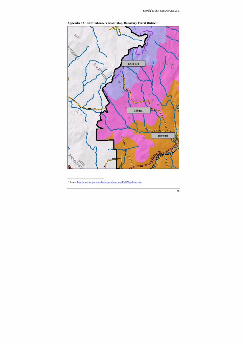
8/12/2019 Mount Baldy
http://slidepdf.com/reader/full/mount-baldy 233/322
Snowy River Resources Ltd.
Appendix 1A: BEC Subzone/Variant Map, Boundary Forest District71
IDFdm1
MSdm1
ESSFdc1
28
71 Source: http://www.for.gov.bc.ca/hre/becweb/papermap/FieldMapsIndex.htm
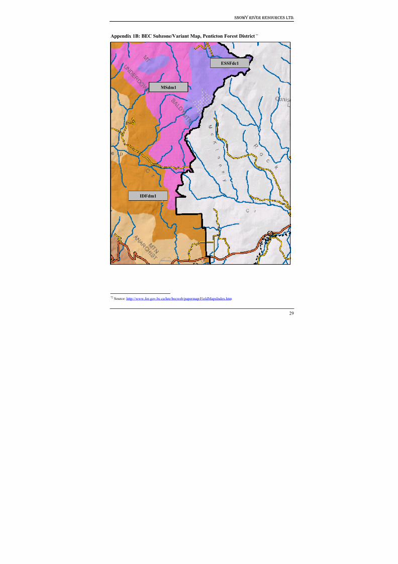
8/12/2019 Mount Baldy
http://slidepdf.com/reader/full/mount-baldy 234/322
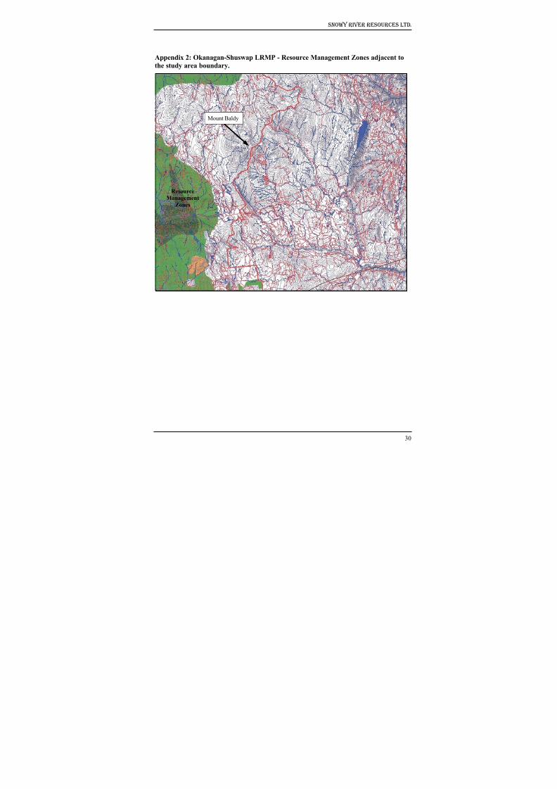
8/12/2019 Mount Baldy
http://slidepdf.com/reader/full/mount-baldy 235/322
Snowy River Resources Ltd.
Appendix 2: Okanagan-Shuswap LRMP - Resource Management Zones adjacent to
the study area boundary.
Mount Baldy
Resource
Management
Zones
30
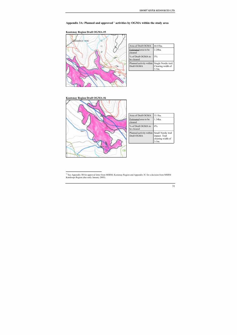
8/12/2019 Mount Baldy
http://slidepdf.com/reader/full/mount-baldy 236/322
Snowy River Resources Ltd.
Appendix 3A: Planned and approved73 activities by OGMA within the study area
Kootenay Region Draft OGMA #5
Area of Draft OGMA 44.03ha.
Estimated area to be
cleared
2.20ha.
% of Draft OGMA to
be cleared
5%
Planned activity within
Draft OGMA
Single Nordic trail.
Clearing width of
3-5m.
Area of Draft OGMA 33.5ha.
Estimated area to be
cleared1.34ha.
% of Draft OGMA to
be cleared
4%
Planned activity within
Draft OGMA
Small Nordic trail
impact. Trailclearing width of
3-5m.
Kootenay Region Draft OGMA #6
31
73 See Appendix 3B for approval letter from MSRM, Kootenay Region and Appendix 3C for a decision from MSRMKamloops Region (due early January 2005).
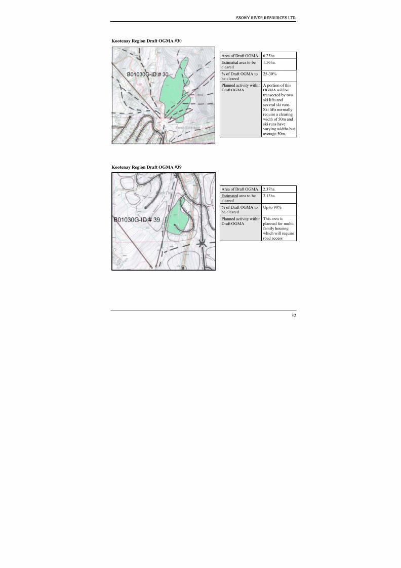
8/12/2019 Mount Baldy
http://slidepdf.com/reader/full/mount-baldy 237/322
Snowy River Resources Ltd.
Kootenay Region Draft OGMA #30
Area of Draft OGMA 6.23ha.
Estimated area to becleared 1.56ha.
% of Draft OGMA to
be cleared
25-30%
Planned activity within
Draft OGMA
A portion of this
OGMA will be
transected by two
ski lifts and
several ski runs.Ski lifts normally
require a clearing
width of 50m andski runs have
varying widths butaverage 50m.
Kootenay Region Draft OGMA #39
Area of Draft OGMA 2.37ha.
Estimated area to be
cleared
2.13ha.
% of Draft OGMA to be cleared
Up to 90%
Planned activity within
Draft OGMA
This area is
planned for multi-family housing
which will require
road access
32
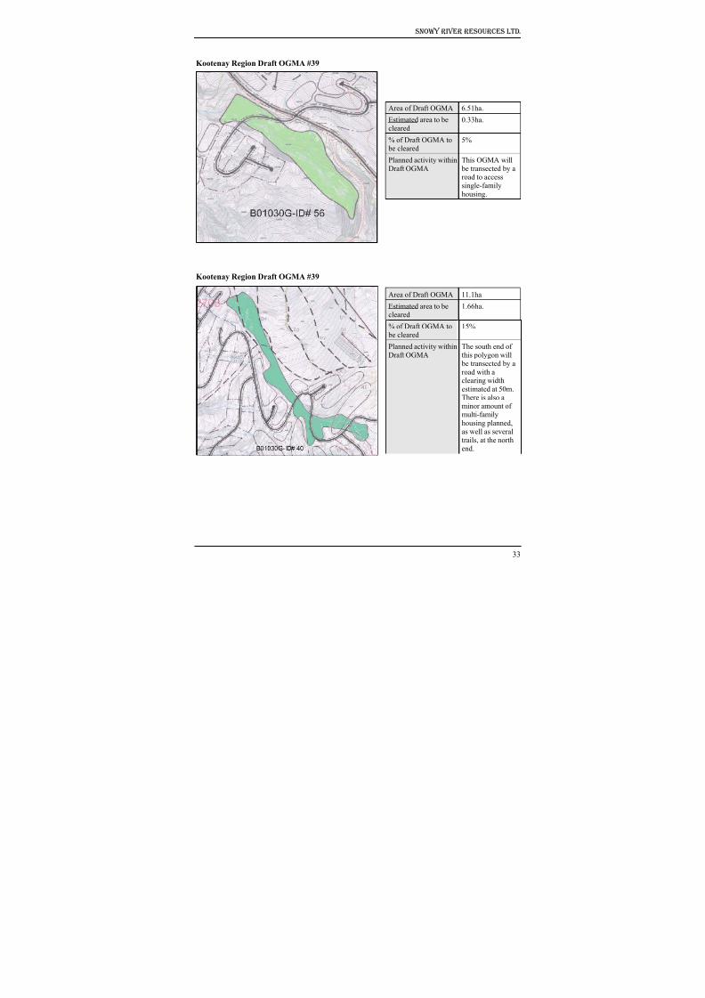
8/12/2019 Mount Baldy
http://slidepdf.com/reader/full/mount-baldy 238/322
Snowy River Resources Ltd.
Kootenay Region Draft OGMA #39
Area of Draft OGMA 6.51ha.
Estimated area to be
cleared0.33ha.
% of Draft OGMA to
be cleared5%
Planned activity within
Draft OGMA
This OGMA will
be transected by aroad to access
single-family
housing.
Kootenay Region Draft OGMA #39
Area of Draft OGMA 11.1ha.
Estimated area to becleared
1.66ha.
% of Draft OGMA to
be cleared
15%
Planned activity within
Draft OGMA
The south end of
this polygon will
be transected by a
road with aclearing width
estimated at 50m.
There is also aminor amount of
multi-family
housing planned,
as well as several
trails, at the north
end.
33
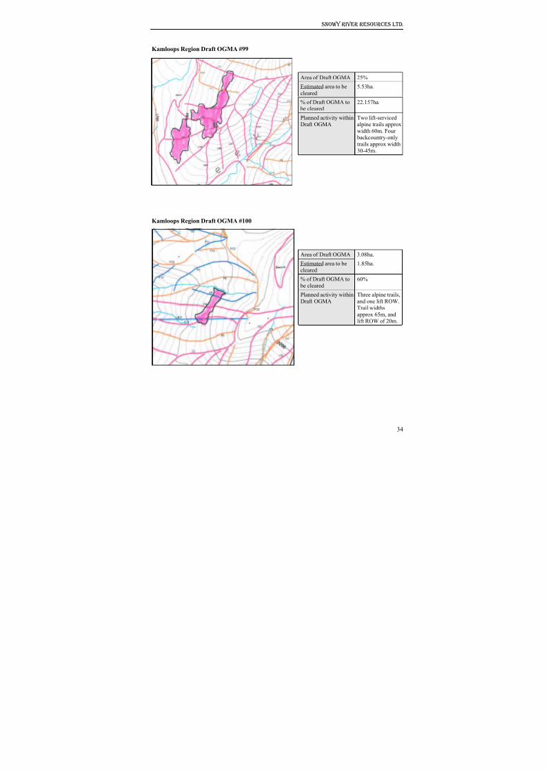
8/12/2019 Mount Baldy
http://slidepdf.com/reader/full/mount-baldy 239/322
Snowy River Resources Ltd.
Kamloops Region Draft OGMA #99
Area of Draft OGMA 25%
Estimated area to becleared
5.53ha.
% of Draft OGMA to
be cleared22.157ha.
Planned activity within
Draft OGMA
Two lift-serviced
alpine trails approx
width 60m. Four backcountry-only
trails approx width
30-45m.
Kamloops Region Draft OGMA #100
Area of Draft OGMA 3.08ha.
Estimated area to becleared
1.85ha.
% of Draft OGMA to
be cleared60%
Planned activity within
Draft OGMA
Three alpine trails,
and one lift ROW.
Trail widthsapprox 65m, and
lift ROW of 20m.
34
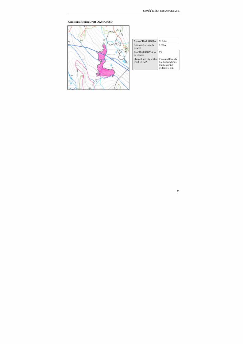
8/12/2019 Mount Baldy
http://slidepdf.com/reader/full/mount-baldy 240/322
Snowy River Resources Ltd.
Kamloops Region Draft OGMA #78D
Area of Draft OGMA 31.24ha.
Estimated area to be
cleared0.62ha.
% of Draft OGMA to
be cleared
2%
Planned activity withinDraft OGMA
Two small NordicTrail interactions.
Trail clearing
width of 3-5m.
35
8/12/2019 Mount Baldy
http://slidepdf.com/reader/full/mount-baldy 241/322
Snowy River Resources Ltd.
Appendix 3B: E-mail correspondence between Frank Wilmer, Senior Planner,
MSRM, Nelson and Doug Wahl, Habitat Biologist, Snowy River Resources Ltd.
regarding the status and management of OGMAs.
From: "Wilmer, Frank SRM:EX" [email protected]
To: "'Doug Wahl'" [email protected]; [email protected]
Cc: [email protected]; [email protected];
[email protected]; [email protected]; Brent Harley and Associates
Subject: RE: Options for relocating draft OGMAs, Mt. Baldi ski hillDate: Friday, December 03, 2004 5:04 PM
I have reviewed your submission and will adjust these OGMA's to account for your proposed
development. I will be dropping draft OGMA 39 and will retain the rest of the OGMA's and
make adjustments where required on the remaining OGMA's in the Kootenay Region. Frank Rowe
can let you know how they will address those OGMA's in the Okanagan.
We accept that you have considered the values in the area in your development planning. Given
that that the proposed use is for a higher use and the proposed OGMA's are only draft at this time, I
am prepared to find alternate areas for OGMA's affected by this proposed development.
If you have any questions, please contact me.
-----Original Message-----
From: Doug Wahl [mailto:[email protected]]
Sent: December 2, 2004 8:36 AM
To: Wilmer, Frank SRM:EX; Rowe, Frank SRM:EX
Cc: Cowtan, Pamela SRM; Grant, Nelson T SRM; Gorsline, Ken SRM; Rowe, Steve LWBC; BrentHarley and Associates; Stewart, Robert WLAP
Subject: Re: Options for relocating draft OGMAs, Mt. Baldi ski hill
Importance: High
Frank/Frank
The Mt. Baldi Ski Corporation has identified a number of mostly minor conflicts with the location
of 9 draft OGMAs and planned ski lift, trails and associated infrastructure. The draft OGMAs are
located within the Kamloops (n=3) and Kootenay (n=6) MSRM regions.
I have attached an overview map showing the study area boundary, as well as maps of individual
OGMAs. With each OGMA map, I have detailed the planned activities and the estimated amountof the OGMA that may be modified. All 9 OGMAs have a total area of 160.4ha. We estimate that
up to 17.22 ha. or 10.7% will be cleared. We have made every effort to provide accurate estimates
of the area (ha.) that may be cleared, however, there may be a margin of error here (say 10-15%i.e., 1-2 ha.).
Once again, the location of the lifts, runs, roads and housing areas are now firm, being located with
due consideration for wildlife habitat suitability, riparian habitat, fish habitat etc. and other
36
8/12/2019 Mount Baldy
http://slidepdf.com/reader/full/mount-baldy 242/322
Snowy River Resources Ltd.
identified resource values. At this stage, we have few options other than to re-locate an additional
18ha. of OGMA in areas outside the planned study area.
Please contact me should you require any further clarification regarding our planned activities. I
would appreciate knowing your planned action at your earliest convenience.
Doug Wahl, RPBio, CPESC, Habitat BiologistSnowy River Resources Ltd.
13807 Latimer Ave.
Summerland BC V0H 1Z1Phone/Cell (250) 809-9093; Fax (250) 404-0229
***************************************************
Habitat Protection for Natural Resource,
Urban & Transportation Development
For your reference:
Ski runs: pink, blue, black, orange and green lines
Lifts: straight linesRoads: the heavier weight black linesSolid line polygons (black/white) indicate multi-family areas
Dot-dash-dot polygons: indicate single family areas
----- Original Message -----
From: Doug mailto:[email protected] Wahl
Cc: [email protected]; [email protected];
[email protected]; [email protected]; [email protected];
[email protected] Associates
Sent: Thursday, November 25, 2004 6:28 PM
Subject: Re: Options for relocating draft OGMAs, Mt. Baldi ski hill
Frank
Thank-you for pursuing this matter so quickly. We will prepare a response under Option 2 (for the
two OGMAs within the base area) and submit it to you for review sometime next week.
Sincerely,
Doug Wahl, RPBio, CPESC, Habitat Biologist
Snowy River Resources Ltd.
13807 Latimer Ave.
Summerland BC V0H 1Z1
Phone/Cell (250) 809-9093; Fax (250) 404-0229
***************************************************
Habitat Protection for Natural Resource,
Urban & Transportation Development
----- Original Message -----
From: [email protected]
37
8/12/2019 Mount Baldy
http://slidepdf.com/reader/full/mount-baldy 243/322
Snowy River Resources Ltd.
Cc: [email protected];
Gorsline, Ken SRM:EX mailto:[email protected]; [email protected];
[email protected]; [email protected]; [email protected]
Sent: Thursday, November 25, 2004 1:29 PM
Subject: RE: Options for relocating draft OGMAs, Mt. Baldi ski hill
Doug,
I think there are 2 options:
Option 1
Leave the OGMA's in place for now. In the future when development is proposed come back to
MSRM for permission to remove the area to be developed from the OGMA. Currently we do nothave any procedures for dealing with this type of situation as we have yet to develop objectives. I
believe that once our objectives have been developed that there will be built in flexibility to allow
for OGMA's to move where needed to accommodate proposals such as yours.
Option 2
Submit a map to us firmly identifying the area that is potentially in conflict with your proposed
development and identifying why it is important to the Ski Hill that it not be included in an
OGMA. It would be useful to indicate a timeframe in which you anticipate development to occur.
Provided that you provide a good rationale for not including the OGMA in the development such
as importance of the area for ski runs and suitability of areas for development compared to other
area available, I would be willing to revise the draft OGMA's to accommodate your development.
Since I am still in the process of finalizing OGMA's for the area I would find appropriate
alternate areas.
If you believe your development will proceed within the next 5 years I would suggest option 1 ismost appropriate but if you foresee development occurring sooner than that then Option 2 is likely
more appropriate.
I hope this helps, if you have any questions, please contact me.
-----Original Message-----
From: Doug Wahl [mailto:[email protected]]
Sent: November 25, 2004 11:23 AM
To: Wilmer, Frank SRM:EX
Cc: Cowtan, Pamela SRM:EX; Gorsline, Ken SRM:EX; Rowe, Frank SRM:EX; Rowe,
Steve LWBC:EX; Stewart, Robert WLAP:EX; Brent Harley and Associates
Subject: Options for relocating draft OGMAs, Mt. Baldi ski hill
Importance: High
Frank
The Mt. Baldy Ski Corporation (the Owner), has asked me to collect environmental baselineinformation for the proposed expansion of the Mt. Baldi Ski area. On June 25, 2004, the Owner and
their primary consultant (Brent Harley and Associates Ltd.) met with the MWLAP and LWBC in
Pentiction to identify resource values and mitigation strategies that should be
38
8/12/2019 Mount Baldy
http://slidepdf.com/reader/full/mount-baldy 244/322
Snowy River Resources Ltd.
addressed within the Master Plan (the plan will be submitted to LWBC on or before December 15,
2004). At the time of the meeting (or subsequent to that), OGMAs were not discussed by the lead
or referral agencies.
I recently became aware of the availability of "draft" OGMA's during FRPA training. Immediately
following that, I contacted you to obtain the location of the draft OGMA's within and immediatelyadjacent to the ski hill. As you can see from the attached map, there are currently 2 OGMA's
(within the area outlined in pink) that conflict with the base area plans. Most notably, a ski lift is
planned through the northernmost OGMA (FID 31, OGMA #9, ID 30). The southernmost OGMAmay also be affected by our plans. For OGMA #9, it is possible that up to 35% of the polygon may
be altered to construct a ski lift and associated infrastructure.
The Mt. Baldy Ski Corporation is very supportive of the initiative to protect old growth and will
make every effort to ensure the integrity of these features within the planned expansion area.However, if treated as reserves, we are concerned that the two OGMAs within the base area present
an unavoidable conflict with our proposed development, which is essentially 'locked in place'.
At your earliest convenience, please provide us with specific direction on our options for theseOGMAs within the base area. Our understanding is that there is the potential to relocate OGMAsentirely or to identify recruitment OGMAs where there are conflicts with other resource uses.
While there is some clarity in the Okanagan-Shuswap LRMP regarding this issue, the Kootenay-
Boundary LRMP is relatively silent on addressing OGMA conflicts.
Thanks again for your assistance on this file.
Sincerely,
Doug Wahl, RPBio, CPESC, Habitat Biologist
Snowy River Resources Ltd.
13807 Latimer Ave.Summerland BC V0H 1Z1
Phone/Cell (250) 809-9093; Fax (250) 404-0229
***************************************************
Habitat Protection for Natural Resource,
Urban & Transportation Development
Yellow background - LU
Green - OGMAs (Kootenay Region)
Pink - OGMAs (Kamloops Region)
Pink outline - current base area, Mt. Baldi Ski Hill
Oval shape defined by 5m contour interval is the study area.
39

8/12/2019 Mount Baldy
http://slidepdf.com/reader/full/mount-baldy 245/322
Snowy River Resources Ltd.
Appendix 3C:
This page reserved for communication between the undersigned and MSRM Kamloops regarding planned
activities within 3 draft OGMAs.
40
8/12/2019 Mount Baldy
http://slidepdf.com/reader/full/mount-baldy 246/322
Snowy River Resources Ltd.
Appendix 4: Record of e-mail communication between Snowy River Resources Ltd.
and the Conservation Data Centre.
From: "Penny, Jenifer L SRM:EX" <[email protected]>To: "'Doug Wahl'" <[email protected]>
Subject: RE: plant information- Mount Baldy
Date: Thursday, September 30, 2004 10:03 AM
Hi Jenine,
I assume that the area inside the blue line is the expansion area that you mention below? I still
stand by what I said in my previous e-mail – that Ipomopsis isn't likely to occur in MS and ESSF,
and this expansion area seems to fall within these zones. The uncertainty for the Ipomopsis record
falls within MS and ESSF, which it really shouldn't so that it part of the problem here. Elsewhere in
its global range, it occurs in plains and valleys, not the mountains so I have a good deal of
confidence that this species wouldn't be there. I think that you have done your due diligence.Rumex paucifolius does occur in the study area though.
Thanks,
Jenifer
-----Original Message-----
From: Doug Wahl [mailto:[email protected]]
Sent: September 30, 2004 9:05 AM
To: Penny, Jenifer L SRM:EX
Subject: plant information- Mount Baldy
Hello Jenifer.
I am attaching the proposed expansion area map for Mount Baldy. You can see from your data base
where the red listed Ipomopsis minutiflora would flank the east side of the expansion, but from the
description "8 miles east of Oliver", it does not look like it should be affected by this development
(considering Mount Baldy is approx. 40km from Oliver). Also, the plant has only been found in
BG, IDF and PP zones in BC. This area falls into the ESSF and MS. I would just like some
assurance when we include this information in the report. In your last e-mail you said that it is
highly unlikely for it to be in this area, just wanted to verify this with the map. What are your
thoughts on this? Thanks again , Jenine Mylymok
From: <[email protected]>
To: "Penny, Jenifer L SRM:EX" <[email protected]>
Cc: <[email protected]>Subject: Re: rare plant record near Baldy mountain
Date: Tuesday, September 28, 2004 12:20 PM
41
8/12/2019 Mount Baldy
http://slidepdf.com/reader/full/mount-baldy 247/322
Snowy River Resources Ltd.
42
Jenifer,
Thank you for all the useful information. I did notice the other plant you
spoke of, Alpine Sorrel (ref#8014, blue listed). I was going to ask you about that one and another
one just out of the development area, Holm's Rocky Mountain Sedge (ref# 6532, blue listed). We
were wanting any additional information on these, including the proper precautions that should beadhered to if development occurs in and around these polygons. I will also contact Marta Donovan
for other possible plants. I was also wondering if there are any other at risk species that you would
know of in this area (animals, invertebrates, etc.). I did not see any on the CDC website, but wantedto double check on this. Thank you again for your time, Jenine
Quoting "Penny, Jenifer L SRM:EX" <[email protected]>:
Jenine,
Thanks for your interest in pursuing the mitigation of developments that occur within CDC rare
plant polygons. The source for the record of Ipomopsis minutiflora near Baldy Mountain is a
herbarium collection whose label simply offered "8 Mi E Of Oliver" for a location. As a result,there is a lot of spatial uncertainty involved with this particular record. Furthermore, it hasn't beenseen since 1961 in this ambiguous location. Recent collections of this species are from Spence's
Bridge, Chopaka customs, Soap Lake, Osoyoos, Painted Bluffs, Lytton, at up to 2500 feet elev
(usually much less though). The 1961 record from E of Oliver occurs at 2000 ft, probably near the
upper limit of its elevation range. I wouldn't expect it in the subalpine. As you see from the
summary report on the web, it has only been observed in low to mid elevations in BC (BG, IDF
and PP zones). I really don' t think it likely occurs where the ski developments are, though I don't
have a study area map to refer to so I won't stake my word on it. Is the ski hill in MS and ESSF?
I noticed that you missed a record in the IMF: it is a much smaller polygon right near the peak of
Baldy Mountain: Rumex paucifolius. Have a look at that record and let me know if you have any
more questions. This species makes sense there - a higher elevation species. Furthermore, Ichecked an associated database of records awaiting data entry and there were no other records for
this area. So you have all that we know exists there. But there is a potential for others because there
haven't been any directed surveys that I know of to identify rare plants in the area. Rumex
paucifolius was found by a knowledgeable rare plant botanist, who likely had his eye out for other
plants at risk, but probably didn't have the time necessary to complete a full survey.
You might want to find out what other higher elevation taxa are known from the forest district.
You could send a request to Marta Donovan ([email protected]) to capture all rare
vascular plant taxa in MS and ESSF in Penticton and Boundary districts then you would have a
potential list to work with. She has a turnaround time of about 10 days for this type of request.
Thanks,
Let me know if I can be of any further assistance, Jenifer
Jenifer Penny, RPBio.
CDC Botanist, Conservation Data CentrePO Box 9358 Stn Prov Govt V8W 9M2
(250) 356-5244 ph (250) 387-2733 fax
4th Floor, 395 Waterfront Crescent, Victoria, BC V8T 5K7

8/12/2019 Mount Baldy
http://slidepdf.com/reader/full/mount-baldy 248/322
AA p p p p e enn d d i i xx 2 2
E nv i r onm en t al A s s e s s m
en t Of f i c e–L e t t er r e: n on-r ev i ew a b l e s t a t u s
8/12/2019 Mount Baldy
http://slidepdf.com/reader/full/mount-baldy 249/322

8/12/2019 Mount Baldy
http://slidepdf.com/reader/full/mount-baldy 250/322

8/12/2019 Mount Baldy
http://slidepdf.com/reader/full/mount-baldy 251/322
AA p p p p e enn d d i i xx 3 3
D e t ai l e d T er r ai n
an d C ar r y i n g C a p a c i t y A
s s e s s m en t s –P h a s e4 (
B ui l d o u t ) C on d i t i on

8/12/2019 Mount Baldy
http://slidepdf.com/reader/full/mount-baldy 252/322
Mt. Baldy Analysis BHA 07/03/2005
POD A
Run Top Bottom Horiz. Vertica l Sl ope Average Ave. Max. Abilit y
N um be r El ev . El ev . L eng th D rop Le ngt h W idt h A re a G ra de G ra de L ev el
(m) (m) (m) (m) (m) (m) (Ha) (%) (%)
A1 206 2.46 19 15.3 9 458. 80 1 47 48 3.29 80. 0 3 .9 3 2 40. 70% Int
A1 - EXT 1913.72 1905.36 30.06 8 31.27 10.0 0.0 28 40.70% Int
A2 208 0.48 18 78.5 3 587. 90 20 2 62 4.94 65. 0 4 .1 3 4 42 .9% Int
A2 - EXT 187 2.66 18 35.3 0 107. 19 3 7 11 3.58 65. 0 0 .7 3 5 42 .9% Int
A3 209 6.22 18 62.1 6 6 45. 32 23 4 68 8.45 7 0. 0 4 .8 3 6 50 .1% Ad v Int
A3 - EXT 185 7.78 18 29.4 0 1 20. 21 28 12 3.75 5 0. 0 0 .6 2 4 50 .1% Ad v Int
A4 2 10 7. 53 1 80 0. 38 9 67 .8 2 30 7 1 02 0. 18 7 0. 0 7 .1 3 2 5 6. 5% Ad v I nt
A5 198 3.62 18 53.7 9 397. 95 13 0 41 9.83 50. 0 2 .1 3 3 38 .1% Int
A6 200 9.77 17 83.8 3 738. 43 22 6 77 5.66 50. 0 3 .9 3 1 40 .9% Int
A7 210 9.47 17 49.3 6 13 03. 16 3 60 1360 .06 70. 0 9 .5 2 8 44 .4% Int
A8 179 3.93 17 42.0 1 2 32. 84 52 23 9.69 3 0. 0 0 .7 2 2 30 .4% Low Int
A9 212 2.16 18 00.0 0 935. 00 32 2 98 8.94 40. 0 4 .0 3 4 63 .6% Exp
A10 203 0.58 18 42.4 8 5 16. 56 18 8 55 2.13 4 0. 0 2 .2 3 6 47 .1% Ad v Int
A11 210 3.67 18 74.7 1 5 51. 76 22 9 60 3.84 5 0. 0 3 .0 4 1 58 .5% Ad v Int
A12 190 7.71 18 10.3 9 2 96. 78 97 31 3.15 5 0. 0 1 .6 3 3 50 .5% Ad v Int
A13 204 3.86 18 27.7 2 7 53. 50 21 6 78 9.56 3 0. 0 2 .4 2 9 45 .6% Ad v IntA14 207 9.98 18 45.3 9 6 81. 02 23 5 72 5.43 6 0. 0 4 .4 3 4 50 .1% Ad v Int
A15 201 6.94 19 05.1 7 3 31. 12 11 2 35 1.67 5 0. 0 1 .8 3 4 50 .1% Ad v Int
STEMWINDER 1 98 7.84 19 47.5 1 2 85. 70 40 28 9.23 2 0. 0 0 .6 1 4 50 .0% Ad v Int
CABIN TRAIL 1896.53 1824.72 4 24.84 72 432.96 0.0 0.0 17 25.0% NovJOLY JACK 1917.41 1877.63 231.76 40 235.86 10.0 0.2 17 2 5. 0% N ov
AC1 212 1.98 17 29.9 6 32 55. 74 3 92 3289 .84 1 0. 0 3 .3 1 2 18 .0% Nov
AC1 - NEW 192 2.27 18 02.1 9 10 63. 01 12 0 1073 .02 2 0. 0 2 .1 1 1 15 .0% Nov
AC2 1839.13 1813.68 237.34 25 238.84 10.0 0.2 11 10.8% adv Int
AC3 2119.22 1729.00 2910.00 390 2936.05 10.0 2.9 13 14.0% Nov
A1-a 1.4 32 40.7% Int Gl
A1-b 3.3 32 40.7% Int Gl
A1-c 0.3 32 40.7% Int Gl
A2-a 4.8 34 42.9% Int Gl
A2-b 1.3 34 42.9% Int Gl
A2-c 0.6 34 42.9% Int Gl
A2-d 0.6 34 42.9% Int Gl
A4-a 0.7 32 56.5% Adv Int Gl
A4-b 1 .6 3 2 56 .5% Ad v Int G l
A4-c 3 .4 3 2 56 .5% Ad v Int G l
A5-a 1.1 33 38.0% Int Gl
A7-a 1.1 28 44.0% Int Gl
A9-a 2.7 34 63.0% Exp Gl
A9-b 2.3 34 63.0% Exp Gl
A9-c 1.4 34 63.0% Exp Gl
A10-a 1 .2 3 6 47 .0% Ad v Int G l
A11-a 0 .1 4 1 58 .5% Ad v Int G l
A11-b 5 .0 4 1 58 .5% Ad v Int G l
A13-a 3 .2 2 9 45 .6% Ad v Int G l
A14-a 6 .2 3 4 50 .1% Ad v Int G l
A15-a 2 .4 3 4 50 .1% Ad v Int G l
A15-b 2 .4 3 4 50 .0% Ad v Int G l
AC1-a 0.5 12 18.0% Int Gl
AC1-b 4.1 12 18.0% Int Gl
AC3-a 0.8 13 14.0% Int Gl
Totals 0 118.4
Run Ave . Max. Ve rt ical Slope A verage Begi nner Novi ce L ow Int . Int Int Adv I nt A dv Int Ex p Exp
N um be r G ra de G ra de D ro p L en gt h W idt h A re a O pe n O pe n O pe n O pe n G la de O pe n G la de O pe n G la de
(%) (%) (m) (m) (m) (Ha) (Ha) (Ha) (Ha) (Ha) (Ha) (Ha) (Ha) (Ha) (Ha) A1 80 41% 147 483 80 3.9 3.9
A1 - EXT 10 41% 8 31 10 0.0 0.0
A2 65 43% 202 625 65 4.1 4.1
A2 - EXT 65 43% 37 114 65 0.7 0.7
A3 70 50% 234 688 70 4.8 4.8
A3 - EXT 50 50% 28 124 50 0.6 0.6
A4 70 57% 307 1,020 70 7.1 7.1
A5 50 38% 130 420 50 2.1 2.1
A6 50 41% 226 776 50 3.9 3.9
A7 70 44% 360 1,360 70 9.5 9.5
A8 30 30% 52 240 30 0.7 0.7
A9 40 64% 322 989 40 4.0 4.0
A10 40 47% 188 552 40 2.2 2.2
A11 50 59% 229 604 50 3.0 3.0
A12 50 51% 97 313 50 1.6 1.6
A13 30 46% 216 790 30 2.4 2.4
A14 60 50% 235 725 60 4.4 4.4
A15 50 50% 112 352 50 1.8 1.8
STEMWINDER 20 50% 40 289 20 0.6 0.6
CABIN TRAIL 0 25% 72 433 0 0.0 0.0
JOLY JACK 10 25% 40 236 10 0.2 0.2
AC1 10 18% 392 3,290 10 3.3 3.3
AC1 - NEW 20 15% 120 1,073 20 2.1 2.1
AC2 10 11% 25 239 10 0.2 0.2
AC3 10 14% 390 2,936 10 2.9 2.9
A1-a 0 41% 0 0 0 1.4 1.4
A1-b 0 41% 0 0 0 3.3 3.3
A1-c 0 41% 0 0 0 0.3 0.3
A2-a 0 43% 0 0 0 4.8 4.8
A2-b 0 43% 0 0 0 1.3 1.3
A2-c 0 43% 0 0 0 0.6 0.6
A2-d 0 43% 0 0 0 0.6 0.6
A4-a 0 57% 0 0 0 0.7 0.7
A4-b 0 57% 0 0 0 1.6 1.6
A4-c 0 57% 0 0 0 3.4 3.4
A5-a 0 38% 0 0 0 1.1 1.1
A7-a 0 44% 0 0 0 1.1 1.1
A9-a 0 63% 0 0 0 2.7 2.7
A9-b 0 63% 0 0 0 2.3 2.3
A9-c 0 63% 0 0 0 1.4 1.4 A10-a 0 47% 0 0 0 1.2 1.2
A11-a 0 59% 0 0 0 0.1 0.1
A11-b 0 59% 0 0 0 5.0 5.0
A13-a 0 46% 0 0 0 3.2 3.2
A14-a 0 50% 0 0 0 6.2 6.2
A15-a 0 50% 0 0 0 2.4 2.4
A15-b 0 50% 0 0 0 2.4 2.4
AC1-a 0 18% 0 0 0 0.5 0.5
AC1-b 0 18% 0 0 0 4.1 4.1
AC3-a 0 14% 0 0 0 0.8 0.8
SKIABLE AREA 118.4 0.0 8.6 0 .7 24.2 19.7 28.7 26.2 4.0 6 .4
B egi nn er N ov ic e L ow I nt . I nt I nt A dv I nt A dv I nt Ex p E xp
O pe n O pe n O pe n O pe n G la de O pe n G la de O pe n G la de S ki T ra il
(Ha) (Ha) (Ha) (Ha) (Ha) (Ha) (Ha) (Ha) (Ha) Capacity
USING LOW DENSITIES
SKIER DENSITY / HECTARE 25.0 21.5 17.0 12.5 1.5 8.5 1.1 6.0 0.6
MAX. SKIERS ON SLOPE BY SKILL RATING 0 185 12 302 30 244 27 24 4 828
% OF MAX. SKIERS 0% 22% 1% 37% 4% 29% 3% 3 % 0 % 100%
AVERAGE DAILY VERTICAL 1,000 2,500 4,000 5,000 2,000 8,500 3,500 10,000 4,000
WEIGHTED VERTICAL DEMAND (M/DAY) 0 559 59 1,826 71 2,502 116 287 18 5,438
USING HIGH DENSITIES
SKIER DENSITY / HECTARE 75.0 60.0 5 0.0 3 5.0 2 5.0 2 5.0 1 2.5 1 5.0 7.5
MAX. SKIERS ON SLOPE BY SKILL RATING 0 516 36 847 493 717 327 59 48 3,043
% OF MAX. SKIERS 0% 17% 1% 28% 16% 24% 11% 2% 2 % 100%
AVERAGE DAILY VERTICAL 1,000 2,500 3,500 4,500 3,000 7,500 5,500 9,000 7,500
WEIGHTED VERTICAL DEMAND (M/DAY) 0 424 41 1,252 486 1,766 591 175 118 4,855
USING MEDIUM DENSITIES
SKIER DENSITY / HECTARE 55.0 45.0 35.0 25.0 17.5 17.5 8.8 10.0 5.0
MAX. SKIERS ON SLOPE BY SKILL RATING 0 387 25 605 345 502 229 40 32 2,165
% OF MAX. SKIERS 0% 18% 1% 28% 16% 23% 11% 2% 1 % 100%
AVERAGE DAILY VERTICAL 1,000 2,500 3,500 4,500 3,000 7,500 5,500 9,000 7,500
WEIGHTED VERTICAL DEMAND (M/DAY) 0 447 41 1,258 478 1,738 582 164 110 4,819
0
10
20
30
40
50
60
S k i a b l e A r e a ( h a )
B e g
N o v
L o w
I n t
I n t
A d v I n t
E x p
Trail Classification
Distribution by Classification
Phase 4 - for appendix
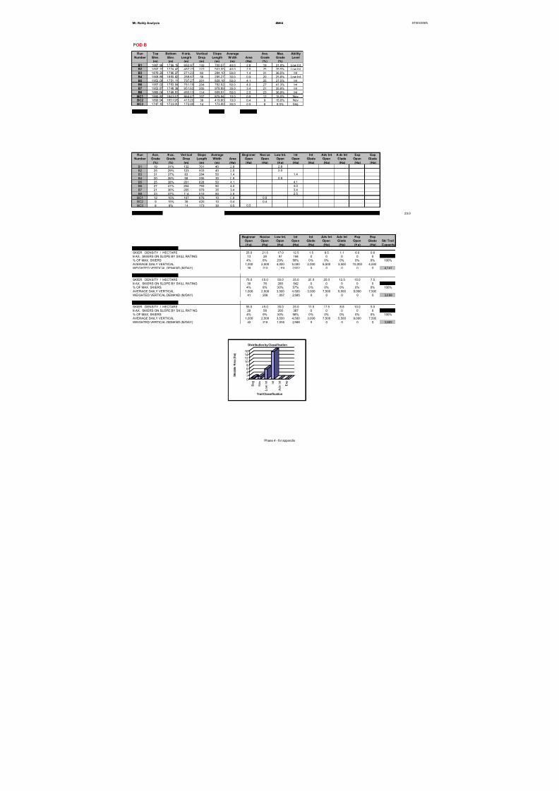
8/12/2019 Mount Baldy
http://slidepdf.com/reader/full/mount-baldy 253/322
Mt. Baldy Analysis BHA 07/03/2005
POD B
Run Top Bottom H oriz. Vertical Slope Average Ave. Max. Ability
Number Elev. Elev. Length Drop Length Width Area Grade Grade Level
(m) (m) (m) (m) (m) (m) (Ha) (%) (%)
B1 1887.96 1756.15 682.97 132 700.57 40.0 2.8 19 31.0% Low Int
B2 1897.22 1774.42 487.23 123 503.05 40.0 2.0 25 28.5% Low Int
B3 1879.29 1796.27 271.23 83 284.10 50.0 1.4 31 36.5% Int
B4 1908.89 1850.62 288.67 58 295.27 30.0 0.9 20 25.8% Low Int
B5 1952.09 1751.11 797.27 201 828.18 50.0 4.1 25 37.5% Int
B6 1957.02 1753.04 761.19 204 792.52 50.0 4.0 27 41.3% Int
B7 1952.87 1748.36 951.62 205 978.89 35.0 3.4 21 35.9% IntB8 1860.04 1746.51 493.13 114 509.51 50.0 2.5 23 36.8% Int
BC1 1950.82 1843.57 864.47 107 875.94 10.0 0.9 12 15.0% Nov
BC2 1890.94 1851.95 413.20 39 419.80 10.0 0.4 9 15.0% Nov
BC3 1747.10 1733.00 172.00 14 173.00 30.0 0.5 8 8.0% beg
Totals 6,361 23.0
Run Ave. Max. Vertical Slope Average Beginner Novice Low Int. Int Int Adv Int A dv Int Exp Exp
Number Grade Grade Drop Length Width Area Open Open Open Open Glade Open Glade Open Glade
(%) (%) (m) (m) (m) (Ha) (Ha) (Ha) (Ha) (Ha) (Ha) (Ha) (Ha) (Ha) (Ha)
B1 19 31% 132 701 40 2.8 2.8
B2 25 29% 123 503 40 2.0 2.0
B3 31 37% 83 284 50 1.4 1.4
B4 20 26% 58 295 30 0.9 0.9B5 25 38% 201 828 50 4.1 4.1
B6 27 41% 204 793 50 4.0 4.0
B7 21 36% 205 979 35 3.4 3.4
B8 23 37% 114 510 50 2.5 2.5
BC1 12 15% 107 876 10 0.9 0.9
BC2 9 15% 39 420 10 0.4 0.4
BC3 8 8% 14 173 30 0.5 0.5
SKIABLE AREA 23.0 0.5 1.3 5.7 15.5 0.0 0.0 0.0 0.0 0.0 23.0
Beginner Novice Low Int. Int Int Adv Int Adv Int Exp Exp
Open Open Open Open Glade Open Glade Open Glade Ski Trail
(Ha) (Ha) (Ha) (Ha) (Ha) (Ha) (Ha) (Ha) (Ha) Capacity
USING LOW DENSITIES
SKIER DENSITY / HECTARE 25.0 21.5 17.0 12.5 1.5 8.5 1.1 6.0 0.6
MAX. SKIERS ON SLOPE BY SKILL RATING 13 28 97 194 0 0 0 0 0 331
% OF MAX. SKIERS 4% 8% 29% 58% 0% 0% 0% 0% 0% 100%
AVERAGE DAILY VERTICAL 1,000 2,500 4,000 5,000 2,000 8,500 3,500 10,000 4,000
WEIGHTED VERTICAL DEMAND (M/DAY) 39 210 1,169 2,922 0 0 0 0 0 4,341
USING HIGH DENSITIES
SKIER DENSITY / HECTARE 75.0 60.0 50.0 35.0 25.0 25.0 12.5 15.0 7.5
MAX. SKIERS ON SLOPE BY SKILL RATING 39 78 285 542 0 0 0 0 0 944
% OF MAX. SKIERS 4% 8% 30% 57% 0% 0% 0% 0% 0% 100%
AVERAGE DAILY VERTICAL 1,000 2,500 3,500 4,500 3,000 7,500 5,500 9,000 7,500
WEIGHTED VERTICAL DEMAND (M/DAY) 41 206 1,057 2,585 0 0 0 0 0 3,889
USING MEDIUM DENSITIES
SKIER DENSITY / HECTARE 55.0 45.0 35.0 25.0 17.5 17.5 8.8 10.0 5.0
MAX. SKIERS ON SLOPE BY SKILL RATING 29 58 200 387 0 0 0 0 0 674
% OF MAX. SKIERS 4% 9% 30% 58% 0% 0% 0% 0% 0% 100%
AVERAGE DAILY VERTICAL 1,000 2,500 3,500 4,500 3,000 7,500 5,500 9,000 7,500
WEIGHTED VERTICAL DEMAND (M/DAY) 42 216 1,036 2,588 0 0 0 0 0 3,883
02468
1012
1416
S k i a b l e A r e a ( h a )
B e g
N o v
L o w
I n t
I n t
A d v I n t
E x p
Trail Classification
Distribution by Classification
Phase 4 - for appendix
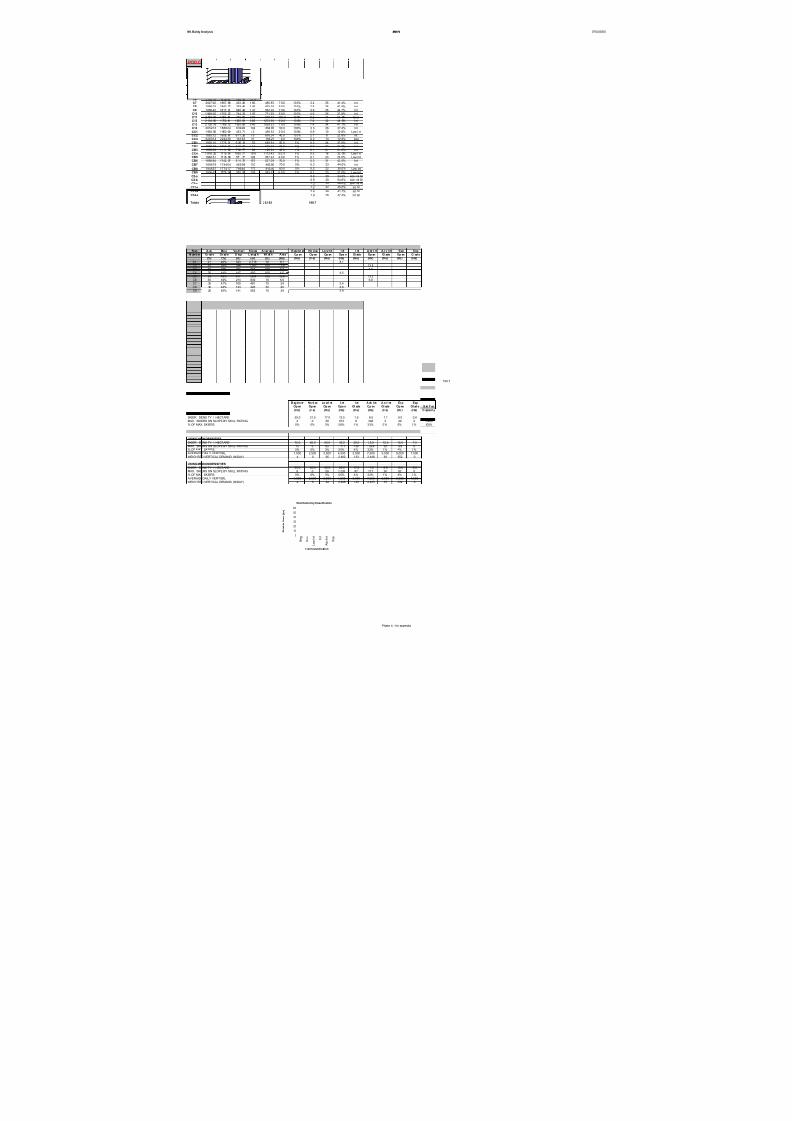
8/12/2019 Mount Baldy
http://slidepdf.com/reader/full/mount-baldy 254/322
Mt. Baldy Analysis BHA 07/03/2005
POD C
Run Top Bottom Horiz. Vertical Slope Average Ave. Max. Ability
N umb er E lev . El ev. L eng th D rop L en gt h Wi dt h Ar ea Gr ad e G rad e L evel
(m) (m) (m) (m) (m) (m) (Ha) (%) (%)
C1 2 288. 32 1 745. 74 2 637. 85 5 43 2716 .17 3 0. 0 10 0% 8 .1 21 39. 5% I nt
C2 2 28 9.67 1 89 5.47 1 30 8.01 3 94 1 38 2.63 1 00 .0 1 00 % 1 3.8 3 0 5 4.6% A dv I nt
C3 2 258. 27 2026. 83 732. 50 23 1 773 .98 100. 0 10 0% 7 .7 32 45. 1% A dv I nt
C4 2 249. 51 2 102. 08 422. 67 1 47 450 .14 100. 0 10 0% 4 .5 35 44. 0% I ntC5 2 28 4.03 1 86 7.16 1 27 9.24 4 17 1 35 4.38 1 00 .0 1 00 % 1 3.5 3 3 4 9.4% A dv I nt
C6 2 193. 70 1919. 87 788. 30 27 4 838 .53 7 0. 0 10 0% 5 .9 35 49 .4% A dv I nt
C7 2027.92 1867. 89 452. 28 1 60 480.85 7 0.0 100% 3.4 35 41.4% Int
C8 1986.03 1842. 72 399. 46 1 43 425.79 6 0.0 100% 2.6 36 43.9% Int
C9 1958.42 1817. 31 540. 48 1 41 562.20 7 0.0 100% 3.9 26 44.7% Int
C10 1 949.05 1752. 22 744. 33 1 97 771.95 6 0.0 100% 4.6 26 37.8% IntC11 2 166. 81 1 861. 51 749. 88 3 05 818 .17 100. 0 10 0% 8 .2 41 61. 0% Ex p
C12 2 134. 92 1 750. 41 1 205. 93 3 85 1273 .96 6 0. 0 10 0% 7 .6 32 44. 9% I nt
C13 2 105. 78 1 766. 12 1 000. 85 3 40 1059 .53 7 0. 0 10 0% 7 .4 34 41. 7% I nt
C14 2052.13 1888.24 639.96 164 664.85 50.0 100% 3.3 26 37.4% Int
CC1 1 993. 80 1 950. 69 453. 71 43 456 .92 2 0. 0 10 0% 0 .9 10 12 .8% Low I nt
CC2 1863.72 1808. 67 6 71. 26 55 676.04 40.0 100% 2.7 8 20.6% int
CC4 2263.14 2242.36 161.63 21 165.27 10.0 100% 0.2 13 12.0% beg
CB1 1928.10 1776. 21 6 28. 19 152 649.64 50.0 5% 0.2 24 37.0% Int
CB2 1900.18 1759. 57 6 10. 67 141 629.22 50.0 5% 0.2 23 37.0% IntCB3 1899.69 1711. 89 7 02. 77 188 728.24 40.0 5% 0.1 27 37.0% Int
CC4 1 918. 25 1719. 24 1090. 77 19 9 1113 .43 5 0. 0 5% 0 .3 18 32. 0% Low I nt
CB5 1846.51 1718. 08 551. 77 128 567.93 4 0.0 5% 0.1 23 28.0% Low Int
CB6 1898.84 1742. 07 5 11. 75 157 537.09 70.0 5% 0.2 31 42.0% Int
CB7 1896.79 1744.04 465.98 153 492.80 70.0 5% 0.2 33 44.0% Int
CB8 1946.57 1774.17 796.46 172 816.40 60.0 5% 0.2 22 35.0% Low Int
CB9 1906.63 1778. 14 570. 53 128 585.92 5 0.0 5% 0.1 23 33.0% Low Int
C2-a 0 .8 30 54 .6% Adv I nt Gl
C2-b 0 .9 30 54 .6% Adv I nt Gl
C2-c 1 .3 30 54 .6% Adv I nt Gl
C12-a 1.2 32 45.0% Int Gl
C13-a 2.4 34 41.7% Int Gl
C14-a 1.9 26 37.4% Int Gl
Totals 20,992 108.7
R un A ve. Ma x. Ve rti ca l S lo pe A ver ag e B eg inn er No vi ce Lo w I nt. I nt I nt A dv I nt A dv I nt Exp Exp
N umb er Gr ad e Gr ad e D rop L en gt h Wi dt h A rea Op en Op en Op en Ope n Gl ade Op en Gl ade Op en Gl ad e(%) (%) (m) (m) (m) (Ha) (Ha) (Ha) (Ha) (Ha) (Ha) (Ha) (Ha) (Ha) (Ha)
C1 21 40% 543 2,716 30 8.1 8.1
C2 30 55% 394 1,383 100 13.8 13.8
C3 32 45% 231 774 100 7.7 7.7
C4 35 44% 147 450 100 4.5 4.5
C5 33 49% 417 1,354 100 13.5 13.5
C6 35 49% 274 839 70 5.9 5.9C7 35 41% 160 481 70 3.4 3.4
C8 36 44% 143 426 60 2.6 2.6
C9 26 45% 141 562 70 3.9 3.9
C10 26 38% 197 772 60 4.6 4.6
C11 41 61% 305 818 100 8.2 8.2
C12 32 45% 385 1,274 60 7.6 7.6C13 34 42% 340 1,060 70 7.4 7.4
C14 26 37% 164 665 50 3.3 3.3
CC1 10 13% 43 457 20 0.9 0.9
CC2 8 21% 55 676 40 2.7 2.7
CC4 13 12% 21 165 10 0.2 0.2
CB1 24 37% 152 650 50 0.2 0.2
CB2 23 37% 141 629 50 0.2 0.2
CB3 27 37% 188 728 40 0.1 0.1
CC4 1 8 3 2% 199 1,113 50 0.3 0.3CB5 23 28% 128 568 40 0.1 0.1
CB6 31 42% 157 537 70 0.2 0.2
CB7 33 44% 153 493 70 0.2 0.2
CB8 22 35% 172 816 60 0.2 0.2
CB9 23 33% 128 586 50 0.1 0.1
C2-a 30 55% 0 0 0 0.8 0.8
C2-b 30 55% 0 0 0 0.9 0.9
C2-c 30 55% 0 0 0 1.3 1.3
C12-a 32 45% 0 0 0 1.2 1.2
C13-a 34 42% 0 0 0 2.4 2.4
C14-a 26 37% 0 0 0 1.9 1.9
SKIABLE AREA 108.7 0.2 0.0 1.7 49.1 5.6 41.0 3.0 8.2 0.0 108.7
B eg inn er No vi ce Lo w I nt. I nt I nt A dv I nt A dv I nt Exp Exp
Op en Op en Op en Ope n Gl ade Op en Gl ade Op en Gl ad e S ki T rai l
(Ha) (Ha) (Ha) (Ha) (Ha) (Ha) (Ha) (Ha) (Ha) C apacity
USING LOW DENSITIES
SKIER DENSITY / HECTARE 25.0 21.5 17.0 12.5 1.5 8.5 1.1 6.0 0.6
MAX. SKIERS ON SLOPE BY SKILL RATING 4 0 29 613 8 348 3 49 0 1,055
% OF MAX. SKIERS 0% 0% 3% 58% 1% 33% 0% 5% 0% 100% AVERAGE DAILY VERTICAL 1,000 2,500 4,000 5,000 2,000 8,500 3,500 10,000 4,000
WEIGHTED VERTICAL DEMAND (M/DAY) 4 0 109 2,906 16 2,806 10 465 0 6,317
USING HIGH DENSITIES
SKIER DENSITY / HECTARE 75.0 60.0 50.0 35.0 25.0 25.0 12.5 15.0 7.5
MAX. SKIERS ON SLOPE BY SKILL RATING 12 0 85 1,717 139 1,024 38 123 0 3,138
% OF MAX. SKIERS 0% 0% 3% 55% 4% 33% 1% 4% 0% 100%
AVERAGE DAILY VERTICAL 1,000 2,500 3,500 4,500 3,000 7,500 5,500 9,000 7,500
WEIGHTED VERTICAL DEMAND (M/DAY) 4 0 95 2,462 133 2,448 66 352 0 5,560
USING MEDIUM DENSITIES
SKIER DENSITY / HECTARE 55.0 45.0 35.0 25.0 17.5 17.5 8.8 10.0 5.0MAX. SKIERS ON SLOPE BY SKILL RATING 9 0 59 1,226 97 717 26 82 0 2,218
% OF MAX. SKIERS 0% 0% 3% 55% 4% 32% 1% 4% 0% 100%
AVERAGE DAILY VERTICAL 1,000 2,500 3,500 4,500 3,000 7,500 5,500 9,000 7,500
WEIGHTED VERTICAL DEMAND (M/DAY) 4 0 94 2,488 132 2,425 65 332 0 5,541
B/C Scale
0
10
20
30
40
50
60
S k i a b l e A r e a ( h a )
B e g
N o v
L o w I n t
I n t
A d v I n t
E x p
Trail Classification
Distribution by Classification
Phase 4 - for appendix
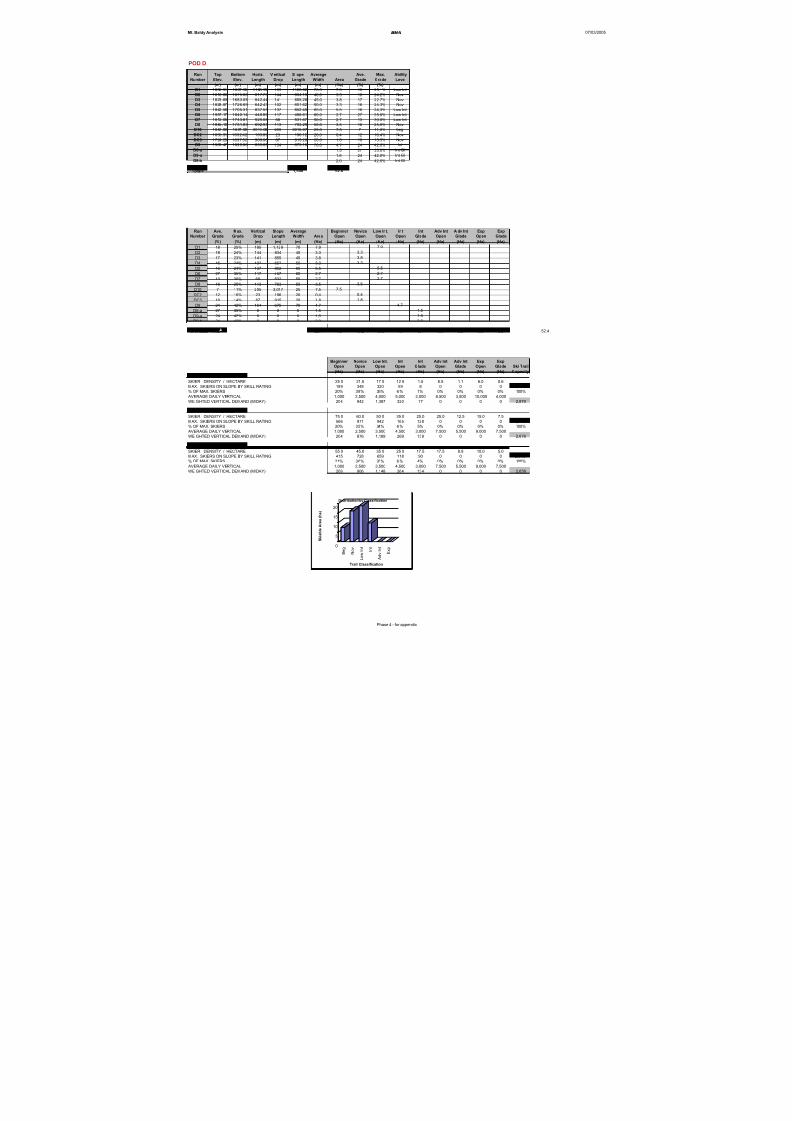
8/12/2019 Mount Baldy
http://slidepdf.com/reader/full/mount-baldy 255/322
Mt. Baldy Analysis BHA 07/03/2005
POD D
Run Top Bottom Horiz. V ertical S lope Average Ave. Max. Ability
Number Elev. Elev. Length Drop Length Width Area Grade Grade Level
(m) (m) (m) (m) (m) (m) (Ha) (%) (%)
D1 1832.91 1637.58 1108.99 195 1128.62 70.0 7.9 18 25.1% Low Int
D2 1818.60 1675.00 817.73 144 834.19 40.0 3.3 18 24.2% Nov
D3 1823.69 1683.05 842.44 141 855.28 45.0 3.8 17 22.7% Nov
D4 1828.87 1726.69 642.43 102 651.62 50.0 3.3 16 24.3% Nov
D5 1842.58 1705.31 837.55 137 852.40 65.0 5.5 16 24.3% Low Int
D6 1957.17 1840.14 440.89 117 456.61 60.0 2.7 27 35.0% Low Int
D7 1812.06 1743.81 525.08 68 531.67 50.0 2.7 13 30.0% Low Int
D8 1845.10 1731.83 692.93 113 703.29 50.0 3.5 16 25.0% NovD10 1842.00 1637.00 3010.00 205 3016.97 25.0 7.5 7 11.0% beg
DC2 1855.31 1832.42 193.89 23 196.12 20.0 0.4 12 16.4% Nov
DC3 1724.29 1637.52 909.06 87 915.28 20.0 1.8 10 13.5% Nov
D9 1983.47 1829.86 653.65 154 675.10 70.0 4.7 24 42.0% Int
D6-a 1.5 27 35.0% Int Gl
D9-a 1.6 24 42.0% Int Gl
D9-b 2.0 24 42.0% Int Gl
Totals 1,590 52.4
Run Ave. Max. Vertical Slope Average Beginner Novice Low Int. Int Int Adv Int A dv Int Exp Exp
Number Grade Grade Drop Length Width Area Open Open Open Open Glade Open Glade Open Glade
(%) (%) (m) (m) (m) (Ha) (Ha) (Ha) (Ha) (Ha) (Ha) (Ha) (Ha) (Ha) (Ha)
D1 18 25% 195 1,129 70 7.9 7.9
D2 18 24% 144 834 40 3.3 3.3D3 17 23% 141 855 45 3.8 3.8
D4 16 24% 102 652 50 3.3 3.3
D5 16 24% 137 852 65 5.5 5.5
D6 27 35% 117 457 60 2.7 2.7
D7 13 30% 68 532 50 2.7 2.7
D8 16 25% 113 703 50 3.5 3.5
D10 7 11% 205 3,017 25 7.5 7.5
DC2 12 16% 23 196 20 0.4 0.4
DC3 10 14% 87 915 20 1.8 1.8
D9 24 42% 154 675 70 4.7 4.7
D6-a 27 35% 0 0 0 1.5 1.5
D9-a 24 42% 0 0 0 1.6 1.6
D9-b 24 42% 0 0 0 2.0 2.0
SKIABLE ARE 52.4 7.5 16.2 18.8 4.7 5.1 0.0 0.0 0.0 0.0 52.4
Beginner Novice Low Int. Int Int Adv Int Adv Int Exp Exp
Open Open Open Open Glade Open Glade Open Glade Ski Trail
(Ha) (Ha) (Ha) (Ha) (Ha) (Ha) (Ha) (Ha) (Ha) Capacity
USING LOW DENSITIES
SKIER DENSITY / HECTARE 25.0 21.5 17.0 12.5 1.5 8.5 1.1 6.0 0.6MAX. SKIERS ON SLOPE BY SKILL RATING 189 348 320 59 8 0 0 0 0 924
% OF MAX. SKIERS 20% 38% 35% 6% 1% 0% 0% 0% 0% 100%
AVERAGE DAILY VERTICAL 1,000 2,500 4,000 5,000 2,000 8,500 3,500 10,000 4,000
WEIGHTED VERTICAL DEMAND (M/DAY) 204 942 1,387 320 17 0 0 0 0 2,870
USING HIGH DENSITIES
SKIER DENSITY / HECTARE 75.0 60.0 50.0 35.0 25.0 25.0 12.5 15.0 7.5
MAX. SKIERS ON SLOPE BY SKILL RATING 566 971 942 165 128 0 0 0 0 2,772
% OF MAX. SKIERS 20% 35% 34% 6% 5% 0% 0% 0% 0% 100%
AVERAGE DAILY VERTICAL 1,000 2,500 3,500 4,500 3,000 7,500 5,500 9,000 7,500
WEIGHTED VERTICAL DEMAND (M/DAY) 204 876 1,189 269 139 0 0 0 0 2,676
USING MEDIUM DENSITIES
SKIER DENSITY / HECTARE 55.0 45.0 35.0 25.0 17.5 17.5 8.8 10.0 5.0
MAX. SKIERS ON SLOPE BY SKILL RATING 415 728 659 118 90 0 0 0 0 2,010
% OF MAX. SKIERS 21% 36% 33% 6% 4% 0% 0% 0% 0% 100%
AVERAGE DAILY VERTICAL 1,000 2,500 3,500 4,500 3,000 7,500 5,500 9,000 7,500
WEIGHTED VERTICAL DEMAND (M/DAY) 206 906 1,148 264 134 0 0 0 0 2,658
0
5
10
15
20
S k i a b l e A r e a ( h a )
B e g
N o v
L o w
I n t
I n t
A d v I n t
E x p
Trail Classification
Distribution by Classification
Phase 4 - for appendix
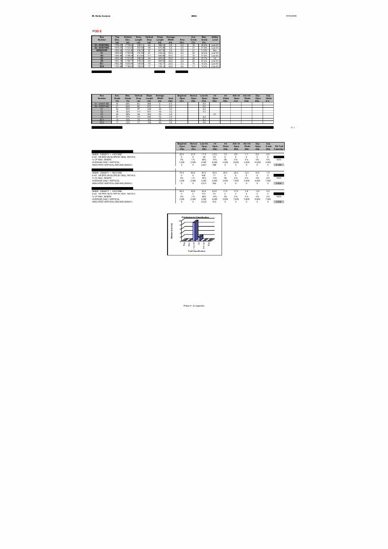
8/12/2019 Mount Baldy
http://slidepdf.com/reader/full/mount-baldy 256/322
Mt. Baldy Analysis BHA 07/03/2005
POD E
Run Top Bottom Horiz. Vertical Slope Average Ave. Max. Ability
Number Elev. Elev. Length Drop Length Width Area Grade Grade Level
(m) (m) (m) (m) (m) (m) (Ha) (%) (%)
E1 - EXISTING 1782.47 1719.42 382.31 63 389.41 0.0 0.0 16 30.2% Low Int
E2 - EXISTING 1816.37 1721.05 461.80 95 475.08 0.0 0.0 21 31.5% Low Int
SIDEDOOR 1820.42 1723.02 455.38 97 467.90 0.0 0.0 21 1 5.0% Nov
E1 1850.63 1753.56 437.68 97 449.22 50.0 2.2 22 30.2% Low Int
E2 1839.68 1728.28 614.60 111 630.86 50.0 3.2 18 31.5% Low Int
E3 1816.24 1721.97 389.26 94 403.02 50.0 2.0 24 37.7% Int
E4 1851.16 1729.77 548.35 121
564.64 50.0 2.8 22 27.2%
Low Int
EC1 1852.50 1833.45 140.89 19 142.77 20.0 0.3 14 15.2% Low Int
EC2 1753.68 1736.43 152.05 17 154.12 40.0 0.6 11 12.2% Low Int
Totals 3,677 11.1
Run Ave. Max. Vertical Slope Average Beginner Novice Low Int. Int Int Adv Int Adv Int Exp Exp
Number Grade Grade Drop Length Width Area Open Open Open Open Glade Open Glade Open Glade
(%) (%) (m) (m) (m) (Ha) (Ha) (Ha) (Ha) (Ha) (Ha) (Ha) (Ha) (Ha) (Ha)
E1 - EXISTING 16 30% 63 389 0 0.0 0.0
E2 - EXISTING 21 32% 95 475 0 0.0 0.0
E1 22 30% 97 449 50 2.2 2.2
E2 18 32% 111 631 50 3.2 3.2
E3 24 38% 94 403 50 2.0 2.0
E4 22 27% 121 565 50 2.8 2.8
EC1 14 15% 19 143 20 0.3 0.3
EC2 11 12% 17 154 40 0.6 0.6
TAL SKIABLE AREA 11.1 0.0 0.0 9.1 2.0 0.0 0.0 0.0 0.0 0.0 11.1
Beginner Novice Low Int. Int Int Adv Int Adv Int Exp Exp
Open Open Open Open Glade Open Glade Open Glade Ski Trail
(Ha) (Ha) (Ha) (Ha) (Ha) (Ha) (Ha) (Ha) (Ha) Capacity
USING LOW DENSITIES
SKIER DENSITY / HECTARE 25.0 21.5 17.0 12.5 1.5 8.5 1.1 6.0 0.6
MAX. SKIERS ON SLOPE BY SKILL RATING 0 0 155 25 0 0 0 0 0 180
% OF MAX. SKIERS 0% 0% 86% 14% 0% 0 % 0% 0% 0 % 100%
AVERAGE DAILY VERTICAL 1,000 2,500 4,000 5,000 2,000 8,500 3,500 10,000 4,000
WEIGHTED VERTICAL DEMAND (M/DAY) 0 0 3,441 698 0 0 0 0 0 4,140
USING HIGH DENSITIES
SKIER DENSITY / HECTARE 75.0 60.0 50.0 35.0 25.0 25.0 12.5 15.0 7.5
MAX. SKIERS ON SLOPE BY SKILL RATING 0 0 456 71 0 0 0 0 0 527
% OF MAX. SKIERS 0% 0% 87% 13% 0% 0 % 0% 0% 0 % 100%
AVERAGE DAILY VERTICAL 1,000 2,500 3,500 4,500 3,000 7,500 5,500 9,000 7,500
WEIGHTED VERTICAL DEMAND (M/DAY) 0 0 3,031 602 0 0 0 0 0 3,634
USING MEDIUM DENSITIES
SKIER DENSITY / HECTARE 55.0 45.0 35.0 2 5.0 17.5 17.5 8.8 10.0 5.0
MAX. SKIERS ON SLOPE BY SKILL RATING 0 0 319 50 0 0 0 0 0 370
% OF MAX. SKIERS 0% 0% 86% 14% 0% 0 % 0% 0% 0 % 100%
AVERAGE DAILY VERTICAL 1,000 2,500 3,500 4,500 3,000 7,500 5,500 9,000 7,500
WEIGHTED VERTICAL DEMAND (M/DAY) 0 0 3,023 613 0 0 0 0 0 3,636
0
2
4
6
8
10
S k i a b l e A r e a ( h a )
B e g
N o v
L
o w
I n t
I n t
A
d v I n t
E x p
Trail Classification
Distribution by Classification
Phase 4 - for appendix
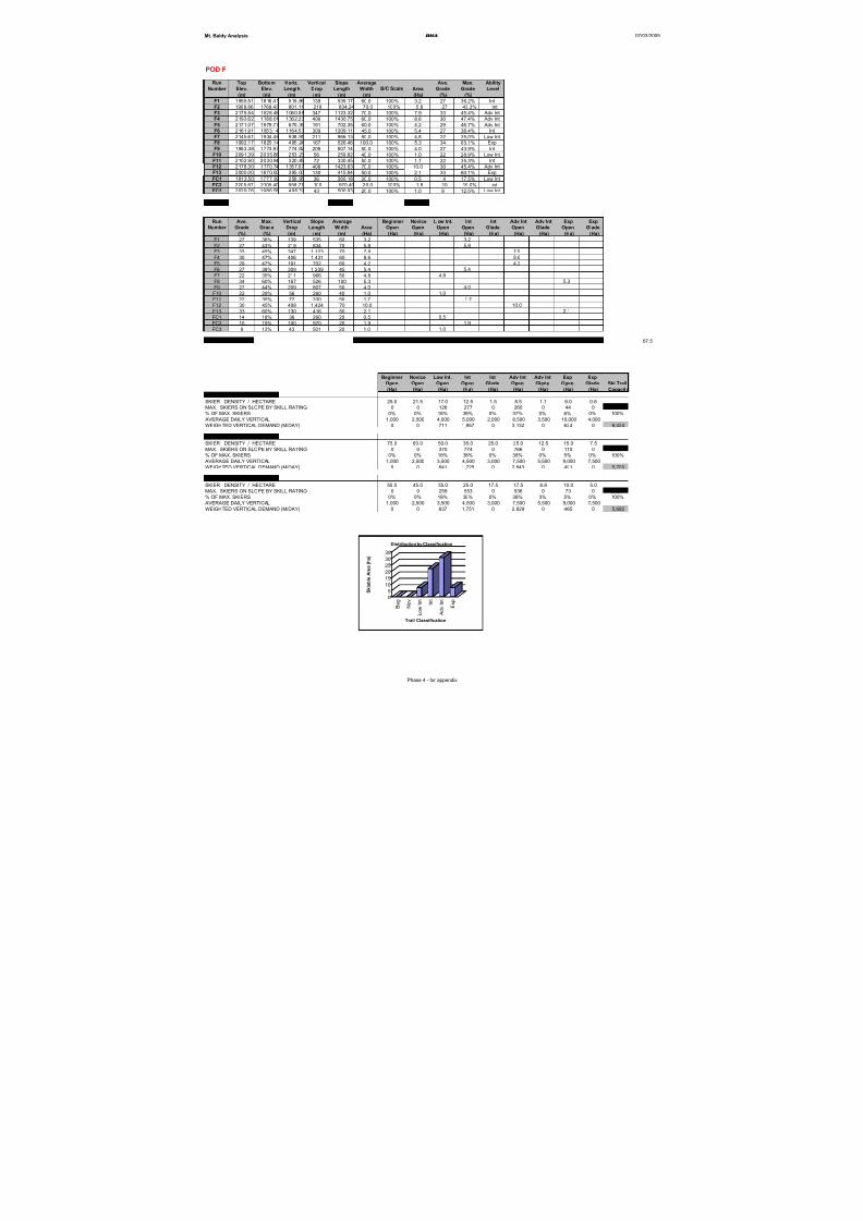
8/12/2019 Mount Baldy
http://slidepdf.com/reader/full/mount-baldy 257/322
Mt. Baldy Analysis BHA 07/03/2005
POD F
Run Top Bottom Horiz. Vertical Slope Average Ave. Max. Ability
Number Elev. Elev. Length Drop Length Width Area Grade Grade Level
(m) (m) (m) (m) (m) (m) (Ha) (%) (%)
F1 1955.51 1816.41 515.86 139 535.17 60.0 100% 3.2 27 36.2% Int
F2 1988.66 1769.43 801.11 219 834.24 70.0 100% 5.8 27 43.3% Int
F3 2175.54 1828.48 1060.59 347 1123.32 70.0 100% 7.9 33 45.4% Adv Int
F4 2193.62 1788.01 1362.23 406 1430.75 60.0 100% 8.6 30 47.4% Adv Int
F5 2171.07 1979.77 670.38 191 702.35 60.0 100% 4.2 29 46.7% Adv Int
F6 2161.91 1853.14 1164.53 309 1209.11 45.0 100% 5.4 27 38.4% Int
F7 2145.61 1934.46 938.91 211 966.13 50.0 100% 4.8 22 35.0% Low IntF8 1992.17 1825.14 495.24 167 526.46 100.0 100% 5.3 34 60.1% Exp
F9 1983.38 1773.97 774.82 209 807.14 50.0 100% 4.0 27 43.9% Int
F10 2091.39 2035.88 253.23 56 259.82 40.0 100% 1.0 22 28.9% Low Int
F11 2102.90 2030.94 320.85 72 330.45 50.0 100% 1.7 22 35.3% Int
F12 2178.30 1770.74 1357.07 408 1423.63 70.0 100% 10.0 30 45.4% Adv Int
F13 2000.00 1870.00 395.00 130 415.84 50.0 100% 2.1 33 60.1% Exp
FC1 1813.50 1777.39 256.95 36 260.18 20.0 100% 0.5 14 17.5% Low Int
FC2 2205.67 2105.40 958.71 100 970.40 20.0 100% 1.9 10 19.0% intFC3 2029.76 1986.58 496.39 43 500.93 20.0 100% 1.0 9 12.5% Low Int
Totals 12,296 67.5
Run Ave. Max. Vertical Slope Average Beginner Novice L ow Int. Int Int Adv Int Adv Int Exp Exp
Number Grade Grade Drop Length Width Area Open Open Open Open Glade Open Glade Open Glade
(%) (%) (m) (m) (m) (Ha) (Ha) (Ha) (Ha) (Ha) (Ha) (Ha) (Ha) (Ha) (Ha)
F1 27 36% 139 535 60 3.2 3.2
F2 27 43% 219 834 70 5.8 5.8
F3 33 45% 347 1,123 70 7.9 7.9
F4 30 47% 406 1,431 60 8.6 8.6
F5 29 47% 191 702 60 4.2 4.2
F6 27 38% 309 1,209 45 5.4 5.4
F7 22 35% 211 966 50 4.8 4.8F8 34 60% 167 526 100 5.3 5.3
F9 27 44% 209 807 50 4.0 4.0
F10 22 29% 56 260 40 1.0 1.0
F11 22 35% 72 330 50 1.7 1.7
F12 30 45% 408 1,424 70 10.0 10.0
F13 33 60% 130 416 50 2.1 2.1
FC1 14 18% 36 260 20 0.5 0.5
FC2 10 19% 100 970 20 1.9 1.9
FC3 9 13% 43 501 20 1.0 1.0
SKIABLE AREA 67.5 0.0 0.0 7.4 22.1 0.0 30.6 0.0 7.3 0.0 67.5
Beginner Novice Low Int. Int Int Adv Int Adv Int Exp Exp
Open Open Open Open Glade Open Glade Open Glade Ski Trail
(Ha) (Ha) (Ha) (Ha) (Ha) (Ha) (Ha) (Ha) (Ha) Capacity
USING LOW DENSITIES
SKIER DENSITY / HECTARE 25.0 21.5 17.0 12.5 1.5 8.5 1.1 6.0 0.6
MAX. SKIERS ON SLOPE BY SKILL RATING 0 0 126 277 0 260 0 44 0 707
% OF MAX. SKIERS 0% 0% 18% 39% 0% 37% 0% 6% 0% 100% AVERAGE DAILY VERTICAL 1,000 2,500 4,000 5,000 2,000 8,500 3,500 10,000 4,000
WEIGHTED VERTICAL DEMAND (M/DAY) 0 0 711 1,957 0 3,132 0 624 0 6,424
USING HIGH DENSITIES
SKIER DENSITY / HECTARE 75.0 60.0 50.0 35.0 25.0 25.0 12.5 15.0 7.5
MAX. SKIERS ON SLOPE BY SKILL RATING 0 0 370 774 0 766 0 110 0 2,020
% OF MAX. SKIERS 0% 0% 18% 38% 0% 38% 0% 5% 0% 100%
AVERAGE DAILY VERTICAL 1,000 2,500 3,500 4,500 3,000 7,500 5,500 9,000 7,500
WEIGHTED VERTICAL DEMAND (M/DAY) 0 0 641 1,725 0 2,843 0 491 0 5,700
USING MEDIUM DENSITIES
SKIER DENSITY / HECTARE 55.0 45.0 35.0 25.0 17.5 17.5 8.8 10.0 5.0
MAX. SKIERS ON SLOPE BY SKILL RATING 0 0 259 553 0 536 0 73 0 1,421
% OF MAX. SKIERS 0% 0% 18% 39% 0% 38% 0% 5% 0% 100%
AVERAGE DAILY VERTICAL 1,000 2,500 3,500 4,500 3,000 7,500 5,500 9,000 7,500
WEIGHTED VERTICAL DEMAND (M/DAY) 0 0 637 1,751 0 2,829 0 465 0 5,682
B/C Scale
0
5
10
15
20
25
3035
S k i a b l e A r e a ( h a )
B e g
N o v
L o w
I n t
I n t
A d v I n t
E x p
Trail Classification
Distribution by Classification
Phase 4 - for appendix
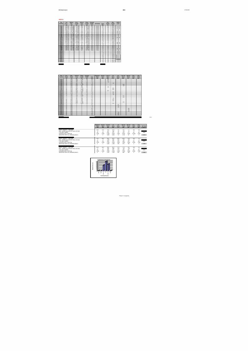
8/12/2019 Mount Baldy
http://slidepdf.com/reader/full/mount-baldy 258/322
Mt. Baldy Analysis BHA 07/03/2005
POD G
Run Top Bottom Horiz. Vertical Slope Average Ave. Max. Ability
Number E lev. Elev. Length Drop Length W idth Area Grade Grade Level
(m) (m) (m) (m) (m) (m) (Ha) (%) (%)
G1 2105.34 1763.41 1741.36 342 1781.29 60.0 100.0% 10.7 20 30.4% Low Int
G2 2063.08 1956.69 375.42 106 391.35 70.0 100.0% 2.7 28 34.4% Low Int
G3 2031.42 1952.80 233.89 79 246.99 40.0 100.0% 1.0 34 34.7% Low Int
G4 2006.17 1905.24 283.92 101 301.75 50.0 100.0% 1.5 36 39.8% Int
G5 1993.81 1691.05 1085.02 303 1135.33 60.0 100.0% 6.8 28 49.8% Adv Int
G6 1995.41 1745.91 754.84 250 799.69 60.0 100.0% 4.8 33 48.8% Adv Int
G7 1992.98 1832.28 781.15 161 800.09 50.0 100.0% 4.0 21 28.6% Low Int
G8 1970.08 1685.68 1133.80 284 1172.45 70.0 100.0% 8.2 25 37.1% Int
G9 1963.35 1682.67 1005.51 281 1046.05 60.0 100.0% 6.3 28 36.7% Int
G10 1952.03 1681.91 1083.31 270 1120.11 60.0 100.0% 6.7 25 34.7% Low Int
G11 1947.65 1764.66 616.50 183 644.67 50.0 100.0% 3.2 30 36.8% Int
G12 1946.68 1776.06 612.14 171 637.39 70.0 100.0% 4.5 28 41.1% IntGC1 2025.59 1950.72 804.30 75 809.53 20.0 100.0% 1.6 12 14.3% int
GC2 2102.38 1998.17 1034.34 104 1044.78 20.0 100.0% 2.1 10 16.0% Adv Int
GC3 1742.04 1706.76 315.31 35 317.48 20.0 100.0% 0.6 11 14.0% Adv Int
GC4 1762.30 1682.66 743.51 80 748.20 20.0 100.0% 1.5 11 12.3% int
GB1 1849.16 1697.81 741.86 151 758.25 40.0 5.0% 0.2 20 36.0% Int
GB2 1936.23 1703.89 906.50 232 938.68 50.0 5.0% 0.2 26 36.0% Int
GB3 1962.23 1663.39 1140.32 299 1186.14 50.0 5.0% 0.3 26 52.0% Adv Int
GB4 1978.15 1661.55 1375.81 317 1417.83 50.0 5.0% 0.4 23 42.0% Int
G3-a 0.7 34 34.7% Int Gl
G3-b 1.8 34 34.7% Int Gl
G4-a 1.0 36 39.8% Int Gl
G5-a 6.9 28 49.8% Adv Int Gl
G6-a 4.8 33 48.8% Adv Int Gl
G6-b 3.8 33 48.8% Adv Int Gl
G8-a 1.6 25 37.1% Int Gl
G9-a 5.4 28 36.7% Int Gl
G10-a 3.9 25 34.7% Int Gl
Totals 17,298 97.3
Run Ave. Max. Vertical Slope Average Beginner N ovice L ow Int. Int Int Adv Int Adv Int Exp Exp
Number Grade Grade Drop Length Width Area Open Open Open Open Glade Open Glade Open Glade
(%) (%) (m) (m) (m) (Ha) (Ha) (Ha) (Ha) (Ha) (Ha) (Ha) (Ha) (Ha) (Ha)
G1 20 30% 342 1,781 60 10.7 10.7G2 28 34% 106 391 70 2.7 2.7
G3 34 35% 79 247 40 1.0 1.0
G4 36 40% 101 302 50 1.5 1.5
G5 28 50% 303 1,135 60 6.8 6.8
G6 33 49% 250 800 60 4.8 4.8
G7 21 29% 161 800 50 4.0 4.0
G8 25 37% 284 1,172 70 8.2 8.2
G9 28 37% 281 1,046 60 6.3 6.3
G10 25 35% 270 1,120 60 6.7 6.7
G11 30 37% 183 645 50 3.2 3.2
G12 28 41% 171 637 70 4.5 4.5
GC1 12 14% 75 810 20 1.6 1.6
GC2 10 16% 104 1,045 20 2.1 2.1
GC3 11 14% 35 317 20 0.6 0.6
GC4 11 12% 80 748 20 1.5 1.5
GB1 20 36% 151 758 40 0.2 0.2
GB2 26 36% 232 939 50 0.2 0.2
GB3 26 52% 299 1,186 50 0.3 0.3
GB4 23 42% 317 1,418 50 0.4 0.4
G3-a 34 35% 0 0 0 0.7 0.7
G3-b 34 35% 0 0 0 1.8 1.8
G4-a 36 40% 0 0 0 1.0 1.0
G5-a 28 50% 0 0 0 6.9 6.9
G6-a 33 49% 0 0 0 4.8 4.8
G6-b 33 49% 0 0 0 3.8 3.8
G8-a 25 37% 0 0 0 1.6 1.6
G9-a 28 37% 0 0 0 5.4 5.4
G10-a 25 35% 0 0 0 3.9 3.9
SKIABLE AREA 97.3 0.0 0.0 25.1 2 7.5 1 4.5 1 4.6 1 5.5 0.0 0.0 97.3
Be gin ne r N ov ice Lo w I nt. I nt I nt Ad v I nt Ad v I nt E xp E xp
Open Open Open Open Glade O pen Glade Open Glade Ski Trail
(Ha) (Ha) (Ha) (Ha) (Ha) (Ha) (Ha) (Ha) (Ha) C apacity
USING LOW DENSITIES
SKIER DENSITY / HECTARE 25.0 21.5 17.0 12.5 1.5 8.5 1.1 6.0 0.6
MAX. SKIERS ON SLOPE BY SKILL RATING 0 0 427 344 22 124 16 0 0 934
% OF MAX. SKIERS 0% 0% 4 6% 37% 2% 1 3% 2 % 0% 0% 100%
AVERAGE DAILY VERTICAL 1,000 2,500 4,000 5,000 2,000 8,500 3,500 10,000 4,000
WEIGHTED VERTICAL DEMAND (M/DAY) 0 0 1,830 1,843 46 1,132 61 0 0 4,913
USING HIGH DENSITIES
SKIER DENSITY / HECTARE 75.0 60.0 50.0 35.0 25.0 25.0 12.5 15.0 7.5
MAX. SKIERS ON SLOPE BY SKILL RATING 0 0 1,257 964 362 366 194 0 0 3,142
% OF MAX. SKIERS 0% 0% 40% 31% 12% 12% 6% 0% 0% 100%
AVERAGE DAILY VERTICAL 1,000 2,500 3,500 4,500 3,000 7,500 5,500 9,000 7,500
WEIGHTED VERTICAL DEMAND (M/DAY) 0 0 1,400 1,380 345 873 340 0 0 4,338
USING MEDIUM DENSITIES
SKIER DENSITY / HECTARE 55.0 45.0 35.0 25.0 17.5 17.5 8.8 10.0 5.0
MAX. SKIERS ON SLOPE BY SKILL RATING 0 0 880 688 253 256 136 0 0 2,213
% OF MAX. SKIERS 0% 0% 40% 31% 11% 12% 6% 0% 0% 100%
AVERAGE DAILY VERTICAL 1,000 2,500 3,500 4,500 3,000 7,500 5,500 9,000 7,500
WEIGHTED VERTICAL DEMAND (M/DAY) 0 0 1,391 1,400 343 868 338 0 0 4,339
B/C Scale
05
1015202530354045
S k i a b l e A r e a ( h a )
B e g
N o v
L o w
I n t
I n t
A d v I n t
E x p
Trail Classification
Distribution by Classification
Phase 4 - for appendix
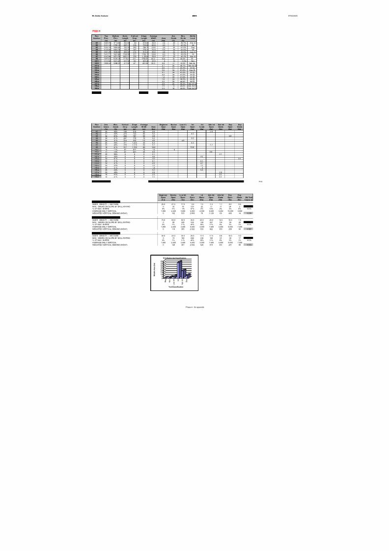
8/12/2019 Mount Baldy
http://slidepdf.com/reader/full/mount-baldy 259/322
Mt. Baldy Analysis BHA 07/03/2005
POD H
Run Top Bottom Horiz. V ertical S lope Average Ave. Max. Ability
Number Elev. Elev. Length Drop Length Width Area Grade Grade Level
(m) (m) (m) (m) (m) (m) (Ha) (%) (%)
H1 1884.76 1715.53 483.00 169 514.90 50.0 2.6 35 49.7% Adv Int
H2 1921.10 1705.13 687.13 216 723.08 60.0 4.3 31 43.3% Int
H3 1944.15 1694.63 742.07 250 786.75 5 0.0 3.9 34 61.0% Exp
H4 1930.98 1683.74 736.25 247 779.24 70.0 5.5 34 41.0% Int
H5 1861.29 1646.84 885.00 214 912.44 50.0 4.6 24 30.5% Low Int
H6 1942.72 1631.90 1208.08 311 1255.15 5 0.0 6.3 26 44.4% Int
H7 1947.86 1671.76 1092.11 276 1135.90 50.0 5.7 25 45.2% Adv Int
H8 1947.03 1630.02 1719.27 317 1759.56 60.0 10.6 18 40.6% Int
HC1 1713.68 1631.43 817.58 82 822.48 20.0 1.6 10 17.3% Nov
HC2 1935.44 1888.35 417.08 47 421.06 20.0 0.8 11 12.5% Adv Int
H1-a 2.1 35 49.7% Adv Int Gl
H2-a 4.6 31 43.3% Int Gl
H3-a 3.5 34 61.0% Exp Gl
H4-a 0.1 34 41.0% Int Gl
H4-b 4.0 34 41.0% Int Gl
H4-c 1.2 34 41.0% Int Gl
H5-a 1.8 24 30.5% Int Gl
H6-a 3.2 26 44.4% Int Gl
H7-a 2.8 25 45.2% Adv Int Gl
H8-a 2.5 18 40.6% Adv Int Gl
H8-b 3.3 18 40.6% Adv Int Gl
Totals 9,111 74.8
Run Ave. Max. Vertical Slope Average Beginner Novice Low Int. Int Int Adv Int Adv Int Exp ExpNumber Grade Grade Drop Length Width Area Open Open Open Open Glade Open Glade Open Glade
(%) (%) (m) (m) (m) (Ha) (Ha) (Ha) (Ha) (Ha) (Ha) (Ha) (Ha) (Ha) (Ha)
H1 35 50% 169 515 50 2.6 2.6
H2 31 43% 216 723 60 4.3 4.3
H3 34 61% 250 787 50 3.9 3.9
H4 34 41% 247 779 70 5.5 5.5
H5 24 31% 214 912 5 0 4.6 4.6
H6 26 44% 311 1,255 50 6.3 6.3
H7 25 45% 276 1,136 50 5.7 5.7
H8 18 41% 317 1,760 60 10.6 10.6
HC1 10 17% 82 822 20 1.6 1.6
HC2 11 13% 47 421 20 0.8 0.8
H1-a 35 50% 0 0 0 2.1 2.1
H2-a 31 43% 0 0 0 4.6 4.6
H3-a 34 61% 0 0 0 3.5 3.5
H4-a 34 41% 0 0 0 0.1 0.1
H4-b 34 41% 0 0 0 4.0 4.0
H4-c 34 41% 0 0 0 1.2 1.2
H5-a 24 31% 0 0 0 1.8 1.8
H6-a 26 44% 0 0 0 3.2 3.2
H7-a 25 45% 0 0 0 2.8 2.8
H8-a 18 41% 0 0 0 2.5 2.5
H8-b 18 41% 0 0 0 3.3 3.3
SKIABLE AREA 74.8 0.0 1.6 4.6 26.6 14.8 9.1 10.7 3.9 3.5 74.8
Beginner Novice Low Int. Int Int Adv Int Adv Int Exp Exp
Open Open Open Open Glade Open Glade Open Glade Ski Trail
(Ha) (Ha) (Ha) (Ha) (Ha) (Ha) (Ha) (Ha) (Ha) Capacity
USING LOW DENSITIES
SKIER DENSITY / HECTARE 25.0 21.5 17.0 12.5 1.5 8.5 1.1 6.0 0.6
MAX. SKIERS ON SLOPE BY SKILL RATING 0 35 78 333 22 77 11 24 2 582
% OF MAX. SKIERS 0% 6% 1 3% 57% 4% 13% 2% 4% 0% 100%
AVERAGE DAILY VERTICAL 1,000 2,500 4,000 5,000 2,000 8,500 3,500 10,000 4,000
WEIGHTED VERTICAL DEMAND (M/DAY) 0 152 533 2,859 76 1,129 68 405 14 5,236
USING HIGH DENSITIES
SKIER DENSITY / HECTARE 75.0 60.0 50.0 35.0 25.0 25.0 12.5 15.0 7.5
MAX. SKIERS ON SLOPE BY SKILL RATING 0 99 228 932 369 227 134 59 26 2,074
% OF MAX. SKIERS 0% 5% 11% 45% 18% 11% 6% 3% 1% 100%
AVERAGE DAILY VERTICAL 1,000 2,500 3,500 4,500 3,000 7,500 5,500 9,000 7,500
WEIGHTED VERTICAL DEMAND (M/DAY) 0 119 385 2,022 533 822 355 256 94 4,587
USING MEDIUM DENSITIES
SKIER DENSITY / HECTARE 55.0 45.0 35.0 25.0 17.5 17.5 8.8 10.0 5.0
MAX. SKIERS ON SLOPE BY SKILL RATING 0 74 160 666 258 159 94 39 17 1,467
% OF MAX. SKIERS 0% 5% 11% 45% 18% 11% 6% 3% 1% 100%
AVERAGE DAILY VERTICAL 1,000 2,500 3,500 4,500 3,000 7,500 5,500 9,000 7,500
WEIGHTED VERTICAL DEMAND (M/DAY) 0 126 381 2,042 528 814 351 241 89 4,572
05
1015202530354045
S k i a b l e A r e a ( h a )
B e g
N o v
L o w
I n t
I n t
A d v I n t
E x p
Trail Classification
Distribution by Classification
Phase 4 - for appendix
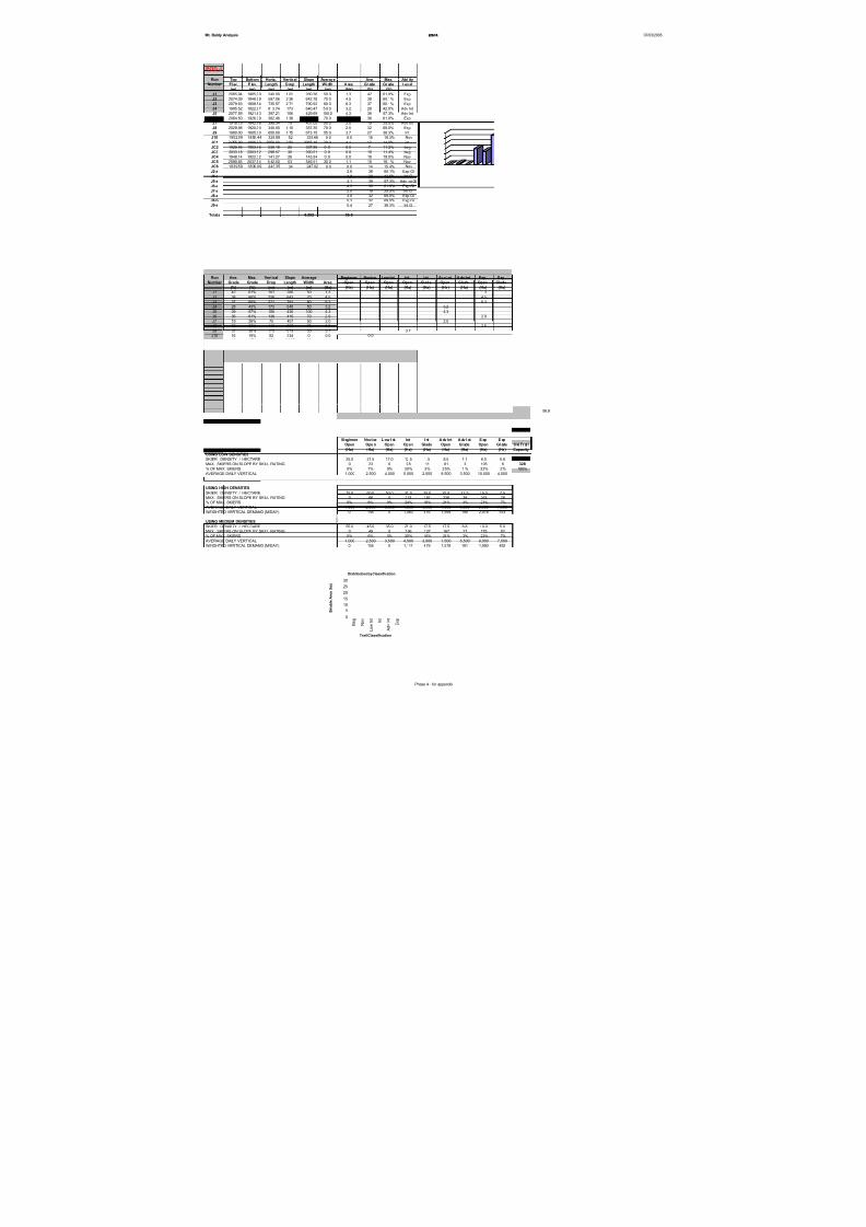
8/12/2019 Mount Baldy
http://slidepdf.com/reader/full/mount-baldy 260/322
Mt. Baldy Analysis BHA 07/03/2005
POD J
Run Top Bottom Horiz. Vertical Slope Average Ave. Max. Ability
Number El ev. E lev. Length D rop Length Wi dth A rea Gr ade Gr ade Lev el
(m) (m) (m) (m) (m) (m) (Ha) (%) (%)
J1 2065.94 1965.00 240.00 1 01 260.36 50.0 1.3 42 61.0% Exp
J2 2074.09 1848.29 597.06 2 26 642.78 70.0 4.5 38 60.1% Exp
J3 2079.63 1808.54 735.57 2 71 790.92 80.0 6.3 37 60.1% Exp
J4 1995.52 1822.97 613.74 173 640.47 5 0.0 3.2 28 42.5% Adv Int
J5 2077.59 1921.83 397.21 156 429.69 100.0 4.3 39 57.3% Adv Int
J6 2064.50 1926.39 382.46 1 38 415.20 70.0 2.9 36 61.0% Exp
J7 1918.15 1842.76 398.34 75 407.00 50.0 2.0 19 25.5% Adv Int
J8 2029.98 1920.00 340.00 1 10 357.35 70.0 2.5 32 69.0% Exp
J9 1980.00 1805.00 650.00 1 75 673.15 55.0 3.7 27 38.3% Int
J10 1902.09 1850.44 328.88 52 333.66 0.0 0.0 16 19.3% NovJC1 2 055.99 1806.00 2050.00 2 50 2065.19 20.0 4.1 12 14.9% int
JC2 1928.46 1903.46 336.18 25 337.86 0 .0 0.0 7 11.2% beg
JC3 2033.18 2003.52 298.57 30 300.51 0 .0 0.0 10 11.4% beg
JC4 1948.14 1922.32 141.27 26 143.94 0 .0 0.0 18 19.0% Nov
JC5 2090.65 2037.54 5 42.50 53 546.51 20.0 1.1 10 16.1% Nov
JC6 1839.59 1806.09 243.35 34 247.02 0.0 0.0 14 15.4% Nov
J2-a 2.8 38 60.1% Exp Gl
J4-a 4.8 28 42.5% Int Gl
J5-a 3.1 39 57.3% Adv Int Gl
J6-a 4.3 36 61.0% Exp Gl
J7-a 2.0 19 25.5% Int Gl
J8-a 3.0 32 69.0% Exp Gl
J8-b 0.3 32 69.0% Exp Gl
J9-a 0.4 27 38.3% Int Gl
Totals 8,592 56.8
Run Ave. Max. Vertical Slope Average Beginner Novice Low Int. Int Int Adv Int A dv Int Exp ExpNumber Grade Grade Drop Length Width Area Open Open Open Open Glade Open Glade Open Glade
(%) (%) (m) (m) (m) (Ha) (Ha) (Ha) (Ha) (Ha) (Ha) (Ha) (Ha) (Ha) (Ha)
J1 42 61% 101 260 50 1.3 1.3
J2 38 60% 226 643 70 4.5 4.5
J3 37 60% 271 791 80 6.3 6.3
J4 28 43% 173 640 50 3.2 3.2
J5 39 57% 156 430 100 4.3 4.3
J6 36 61% 138 415 70 2.9 2.9
J7 19 26% 75 407 50 2.0 2.0
J8 32 69% 110 357 70 2.5 2.5
J9 27 38% 175 673 55 3.7 3.7
J10 16 19% 52 334 0 0.0 0.0
JC1 12 15% 250 2,065 20 4.1 4.1
JC2 7 11% 25 338 0 0.0 0.0
JC3 10 11% 30 301 0 0.0 0.0JC4 18 19% 26 144 0 0.0 0.0JC5 10 16% 53 547 20 1.1 1.1
JC6 14 15% 34 247 0 0.0 0.0
J2-a 38 60% 0 0 0 2.8 2.8
J4-a 28 43% 0 0 0 4.8 4.8
J5-a 39 57% 0 0 0 3.1 3.1
J6-a 36 61% 0 0 0 4.3 4.3
J7-a 19 26% 0 0 0 2.0 2.0J8-a 32 69% 0 0 0 3.0 3.0J8-b 32 69% 0 0 0 0.3 0.3J9-a 27 38% 0 0 0 0.4 0.4
SKIABLE ARE 56.8 0.0 1.1 0.0 7.8 7.2 9.5 3.1 17.5 10.4 56.8
B eginner Novi ce L ow I nt. Int I nt A dv Int A dv I nt E xp E xp
Open Ope n Open Open Glade Open Gl ade Open Gl ade S ki Tr ai l
(Ha) (Ha) (Ha) (Ha) (Ha) (Ha) (Ha) (Ha) (Ha) Capacity
USING LOW DENSITIES
SKIER DENSITY / HECTARE 25.0 21.5 17.0 12.5 1.5 8.5 1.1 6.0 0.6
MAX. SKIERS ON SLOPE BY SKILL RATING 0 23 0 98 11 81 3 105 6 328
% OF MAX. SKIERS 0% 7% 0% 30% 3% 25% 1% 32% 2% 100%
AVERAGE DAILY VERTICAL 1,000 2,500 4,000 5,000 2,000 8,500 3,500 10,000 4,000
WEIGHTED VERTICAL DEMAND (M/DAY) 0 179 0 1,492 66 2,100 35 3,207 76 7,156
USING HIGH DENSITIES
SKIER DENSITY / HECTARE 75.0 60.0 50.0 35.0 25.0 25.0 12.5 15.0 7.5
MAX. SKIERS ON SLOPE BY SKILL RATING 0 66 0 274 181 238 39 263 78 1,139
% OF MAX. SKIERS 0% 6% 0% 24% 16% 21% 3% 23% 7% 100%
AVERAGE DAILY VERTICAL 1,000 2,500 3,500 4,500 3,000 7,500 5,500 9,000 7,500
WEIGHTED VERTICAL DEMAND (M/DAY) 0 144 0 1,083 476 1,569 190 2,078 514 6,054
USING MEDIUM DENSITIES
SKIER DENSITY / HECTARE 55.0 45.0 35.0 25.0 17.5 17.5 8.8 10.0 5.0
MAX. SKIERS ON SLOPE BY SKILL RATING 0 49 0 196 127 167 27 175 52 793
% OF MAX. SKIERS 0% 6% 0% 25% 16% 21% 3% 22% 7% 100%
AVERAGE DAILY VERTICAL 1,000 2,500 3,500 4,500 3,000 7,500 5,500 9,000 7,500
WEIGHTED VERTICAL DEMAND (M/DAY) 0 155 0 1,111 479 1,578 191 1,990 492 5,994
0
5
10
15
20
25
30
S k i a b l e A r e a ( h a )
B e g
N o v
L o w
I n t
I n t
A d v I n t
E x p
Trail Classification
Distribution by Classification
Phase 4 - for appendix
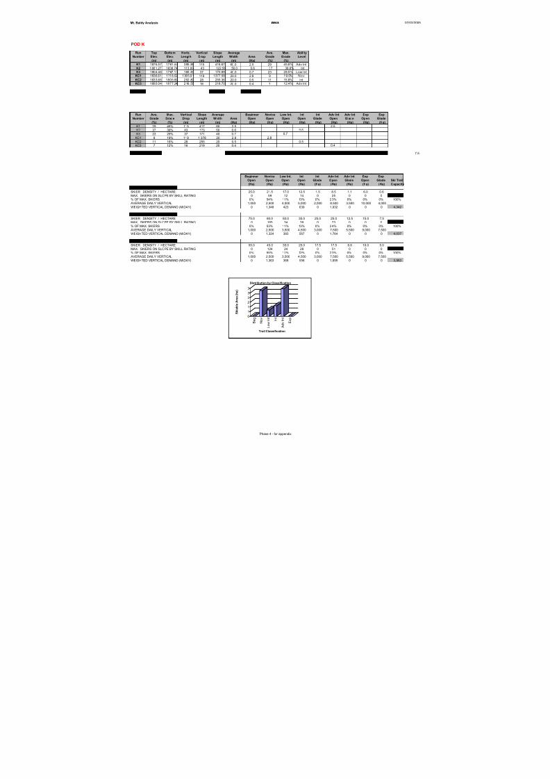
8/12/2019 Mount Baldy
http://slidepdf.com/reader/full/mount-baldy 261/322
Mt. Baldy Analysis BHA 07/03/2005
POD K
Run Top Bottom Horiz. Vertical Slope Average Ave. Max. Ability
Number Elev. Elev. Length Drop Length Width Area Grade Grade Level
(m) (m) (m) (m) (m) (m) (Ha) (%) (%)
K1 1876.57 1761.44 395.88 115 416.67 60.0 2.5 29 45.8% Adv Int
K2 1881.27 1838.74 113.99 43 122.56 50.0 0.6 37 38.8% Int
K3 1804.46 1767.13 165.83 37 170.89 40.0 0.7 23 28.5% Low Int
KC1 1836.61 1718.02 1365.91 119 1377.58 20.0 2.8 9 19.0% Nov
KC2 1833.66 1805.69 252.80 28 255.36 20.0 0.5 11 15.8% int
KC3 1893.04 1877.24 216.57 16 218.70 20.0 0.4 7 12.4% Adv Int
Totals 2,562 7.5
Run Ave. Max. Vertical Slope Average Beginner Novice Low Int. Int Int Adv Int Adv Int Exp Exp
Number Grade Grade Drop Length Width Area Open Open Open Open Glade Open Glade Open Glade
(%) (%) (m) (m) (m) (Ha) (Ha) (Ha) (Ha) (Ha) (Ha) (Ha) (Ha) (Ha) (Ha)
K1 29 46% 115 417 60 2.5 2.5
K2 37 39% 43 123 50 0.6 0.6
K3 23 29% 37 171 40 0.7 0.7
KC1 9 19% 119 1,378 20 2.8 2.8
KC2 11 16% 28 255 20 0.5 0.5
KC3 7 12% 16 219 20 0.4 0.4
SKIABLE AREA 7.5 0.0 2.8 0.7 1.1 0.0 2.9 0.0 0.0 0.0 7.5
Beginner Novice Low Int. Int Int Adv Int Adv Int Exp ExpOpen Open Open Open Glade Open Glade Open Glade Ski Trail
(Ha) (Ha) (Ha) (Ha) (Ha) (Ha) (Ha) (Ha) (Ha) Capacity
USING LOW DENSITIES
SKIER DENSITY / HECTARE 25.0 21.5 17.0 12.5 1.5 8.5 1.1 6.0 0.6
MAX. SKIERS ON SLOPE BY SKILL RATING 0 59 12 14 0 25 0 0 0 110
% OF MAX. SKIERS 0% 54% 11% 13% 0% 23% 0% 0% 0% 100%
AVERAGE DAILY VERTICAL 1,000 2,500 4,000 5,000 2,000 8,500 3,500 10,000 4,000
WEIGHTED VERTICAL DEMAND (M/DAY) 0 1,348 423 639 0 1,932 0 0 0 4,342
USING HIGH DENSITIES
SKIER DENSITY / HECTARE 75.0 60.0 50.0 35.0 25.0 25.0 12.5 15.0 7.5
MAX. SKIERS ON SLOPE BY SKILL RATING 0 165 34 39 0 73 0 0 0 312
% OF MAX. SKIERS 0% 53% 11% 13% 0% 24% 0% 0% 0% 100%
AVERAGE DAILY VERTICAL 1,000 2,500 3,500 4,500 3,000 7,500 5,500 9,000 7,500
WEIGHTED VERTICAL DEMAND (M/DAY) 0 1,324 383 567 0 1,764 0 0 0 4,037
USING MEDIUM DENSITIES
SKIER DENSITY / HECTARE 55.0 45.0 35.0 25.0 17.5 17.5 8.8 10.0 5.0
MAX. SKIERS ON SLOPE BY SKILL RATING 0 124 24 28 0 51 0 0 0 227
% OF MAX. SKIERS 0% 55% 11% 12% 0% 23% 0% 0% 0% 100%
AVERAGE DAILY VERTICAL 1,000 2,500 3,500 4,500 3,000 7,500 5,500 9,000 7,500
WEIGHTED VERTICAL DEMAND (M/DAY) 0 1,363 368 556 0 1,695 0 0 0 3,983
0
1
1
2
2
3
3
S k i a b l e A r e a ( h a )
B e g
N o v
L o w
I n t
I n t
A d v I n t
E x p
Trail Classification
Distribution by Classification
Phase 4 - for appendix
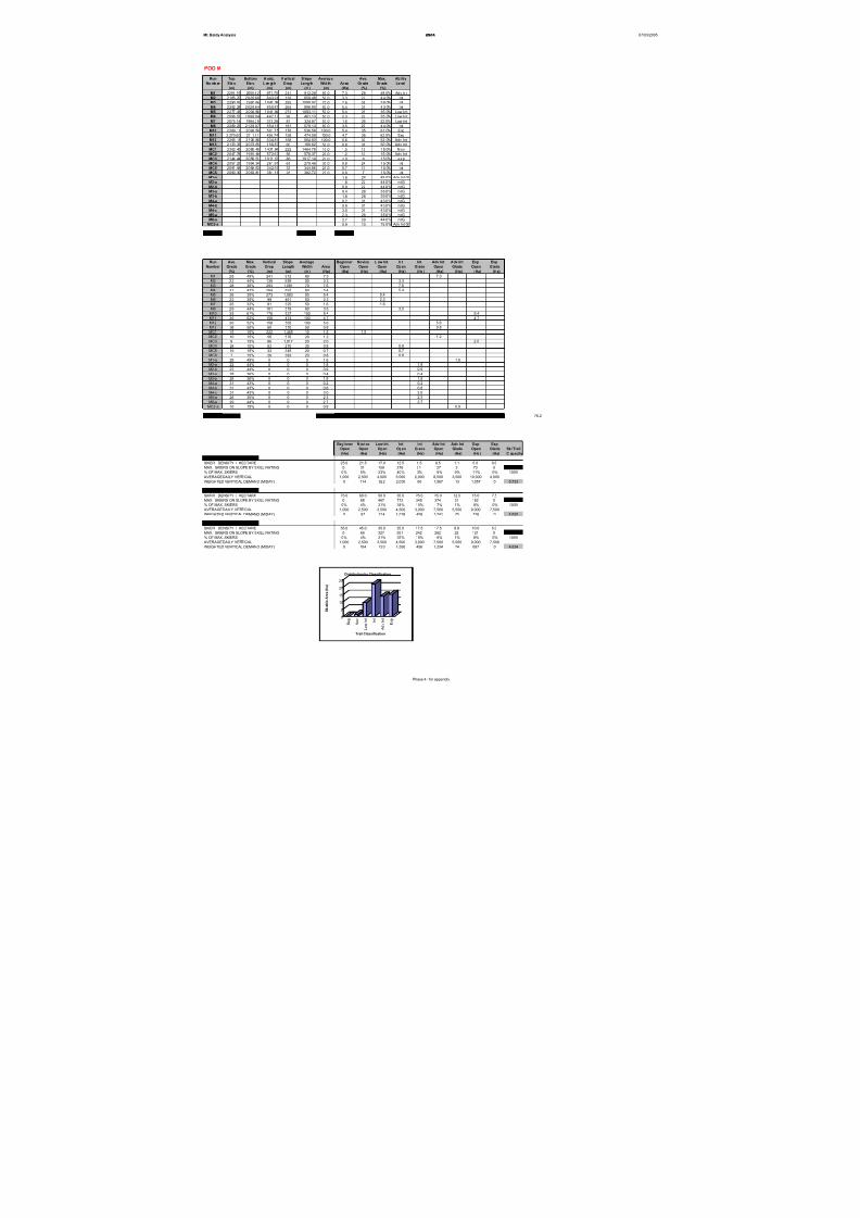
8/12/2019 Mount Baldy
http://slidepdf.com/reader/full/mount-baldy 262/322
Mt. Baldy Analysis BHA 07/03/2005
POD M
Run Top Bottom H oriz. V ertical S lope Average Ave. Max. Ability
Nu mb er Ele v. Ele v. L en gt h D rop Le ng th Wid th Ar ea Gr ade Gr ade Le vel
(m) (m) (m) (m) (m) (m) (Ha) (%) (%)
M1 2291.15 2050.62 871.70 241 912.28 80.0 7.3 28 49.0% Adv Int
M2 2165.70 2026.66 643.24 139 659.48 50.0 3.3 22 44. 0% I nt
M3 2290.81 1997.64 1042.38 293 1090.97 70.0 7.6 28 36. 0% I nt
M4 2292.28 2028.64 850.81 264 896.90 60.0 5.4 31 43. 0% I nt
M5 2277.43 2004.86 1041.94 273 1083.11 50.0 5.4 26 35.0% Low Int
M6 2096.57 1998.04 447.17 99 461.13 50.0 2.3 22 35.0% Low Int
M7 2075.74 1994.29 313.28 81 324.87 50.0 1.6 26 32.0% Low Int
M8 2289.23 2128.07 554.18 161 579.13 60.0 3.5 29 44. 0% I nt
M10 2269.11 2093.54 501.75 176 536.58 100.0 5.4 35 61.0% Exp
M11 2 270.60 2111.51 436.74 159 474.09 100.0 4.7 36 62.0% Exp
M12 2265.18 2106.86 534.87 158 564.83 100.0 5.6 30 52.0% Adv Int
M13 2133.33 2073.65 156.87 60 169.62 50.0 0.8 38 50.0% Adv Int
MC1 2302.45 2080.49 1437.84 222 1464.78 10.0 1.5 15 15.0% Nov
MC2 2047.78 1991.48 572.63 56 576.37 20.0 1.2 10 15.0% Adv Int
MC3 2144.44 2058.51 1011.12 86 1017.14 20.0 2.0 8 15.0% exp
MC4 2057.23 1994.34 261.91 63 270.46 30.0 0.8 24 15. 0% int
MC5 2091.58 2058.63 342.59 33 344.86 20.0 0.7 10 15. 0% int
MC6 2090.30 2063.81 381.16 26 382.72 20.0 0.8 7 15. 0% int
M1-a 1.6 28 49.0% Adv Int Gl
M2-a 1.8 22 44.0% Int Gl
M2-b 0.9 22 44.0% Int Gl
M3-a 0.4 28 36.0% Int Gl
M3-b 1.8 28 36.0% Int Gl
M4-a 0.2 31 43.0% Int Gl
M4-b 0.8 31 43.0% Int Gl
M4-c 3.0 31 43.0% Int Gl
M5-a 2.3 26 35.0% Int Gl
M8-a 2.7 29 44.0% Int Gl
MC2-a 0.9 10 15.0% Adv Int Gl
Totals 11,809 76.2
Run Ave. Max. Vertical Slope Average Beginner Novice L ow Int. Int Int Adv Int Adv Int Exp Exp
Number Grade Grade Drop Length Width Area Open Open Open Open Glade Open Glade Open Glade
(%) (%) (m) (m) (m) (Ha) (Ha) (Ha) (Ha) (Ha) (Ha) (Ha) (Ha) (Ha) (Ha)
M1 28 49% 241 912 80 7.3 7.3M2 22 44% 139 659 50 3.3 3.3
M3 28 36% 293 1,091 70 7.6 7.6
M4 31 43% 264 897 60 5.4 5.4
M5 26 35% 273 1,083 50 5.4 5.4
M6 22 35% 99 461 50 2.3 2.3
M7 26 32% 81 325 50 1.6 1.6
M8 29 44% 161 579 60 3.5 3.5
M10 35 61% 176 537 100 5.4 5.4
M11 36 62% 159 474 100 4.7 4.7
M12 30 52% 158 565 100 5.6 5.6
M13 38 50% 60 170 50 0.8 0.8
MC1 15 15% 222 1,465 10 1.5 1.5
MC2 10 15% 56 576 20 1.2 1.2
MC3 8 15% 86 1,017 20 2.0 2.0
MC4 24 15% 63 270 30 0.8 0.8
MC5 10 15% 33 345 20 0.7 0.7
MC6 7 15% 26 383 20 0.8 0.8
M1-a 28 49% 0 0 0 1.6 1.6
M2-a 22 44% 0 0 0 1.8 1.8
M2-b 22 44% 0 0 0 0.9 0.9
M3-a 28 36% 0 0 0 0.4 0.4
M3-b 28 36% 0 0 0 1.8 1.8
M4-a 31 43% 0 0 0 0.2 0.2
M4-b 31 43% 0 0 0 0.8 0.8
M4-c 31 43% 0 0 0 3.0 3.0
M5-a 26 35% 0 0 0 2.3 2.3
M8-a 29 44% 0 0 0 2.7 2.7
MC2-a 10 15% 0 0 0 0.9 0.9
SKIABLE AREA 76.2 0.0 1.5 9.3 22.1 13.8 14.9 2.5 12.1 0.0 76.2
Beginner N ovice Low Int. Int Int Adv Int Adv Int Exp Exp
Open Open Open Open Glade Open Glade Open Glade Ski Trail
(Ha) (Ha) (Ha) (Ha) (Ha) (Ha) (Ha) (Ha) (Ha) C apacity
USING LOW DENSITIES
SKIER DENSITY / HECTARE 25.0 21.5 17.0 12.5 1.5 8.5 1.1 6.0 0.6
MAX. SKIERS ON SLOPE BY SKILL RATING 0 31 159 276 21 127 3 73 0 689
% OF MAX. SKIERS 0% 5% 23% 40% 3% 18% 0% 11% 0% 100%
AVERAGE DAILY VERTICAL 1,000 2,500 4,000 5,000 2,000 8,500 3,500 10,000 4,000
WEIGHTED VERTICAL DEMAND (M/DAY) 0 114 922 2,000 60 1,567 13 1,057 0 5,733
USING HIGH DENSITIES
SKIER DENSITY / HECTARE 75.0 60.0 50.0 35.0 25.0 25.0 12.5 15.0 7.5
MAX. SKIERS ON SLOPE BY SKILL RATING 0 88 467 772 345 374 31 182 0 2,259
% OF MAX. SKIERS 0% 4% 21% 34% 15% 17% 1% 8% 0% 100%
AVERAGE DAILY VERTICAL 1,000 2,500 3,500 4,500 3,000 7,500 5,500 9,000 7,500
WEIGHTED VERTICAL DEMAND (M/DAY) 0 97 724 1,538 458 1,241 75 726 0 4,859
USING MEDIUM DENSITIES
SKIER DENSITY / HECTARE 55.0 45.0 35.0 25.0 17.5 17.5 8.8 10.0 5.0
MAX. SKIERS ON SLOPE BY SKILL RATING 0 66 327 551 242 262 22 121 0 1,590
% OF MAX. SKIERS 0% 4% 21% 35% 15% 16% 1% 8% 0% 100%
AVERAGE DAILY VERTICAL 1,000 2,500 3,500 4,500 3,000 7,500 5,500 9,000 7,500
WEIGHTED VERTICAL DEMAND (M/DAY) 0 104 720 1,560 456 1,234 74 687 0 4,834
0
5
10
15
20
25
S k i a b l e A r e a ( h a )
B e g
N o v
L o w
I n t
I n t
A d v I n t
E x p
Trail Classification
Distribution by Classification
Phase 4 - for appendix
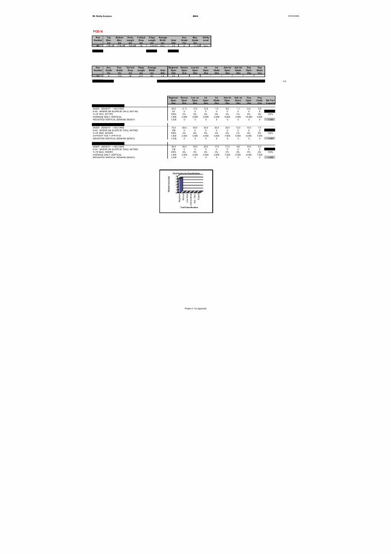
8/12/2019 Mount Baldy
http://slidepdf.com/reader/full/mount-baldy 263/322
Mt. Baldy Analysis BHA 07/03/2005
POD N
Run Top Bottom Horiz. V ertical S lope Average Ave. Max. Ability
Number Elev. Elev. Length Drop Length Width Area Grade Grade Level
(m) (m) (m) (m) (m) (m) (Ha) (%) (%)
N1 1765.00 1735.00 395.88 30 416.67 60.0 2.5 8 11.0% beg
Totals 417 2.5
Run Ave. Max. Vertical Slope Average Beginner Novice Low Int. Int Int Adv Int Adv Int Exp Exp
Number Grade Grade Drop Length Width Area Open Open Open Open Glade Open Glade Open Glade
(%) (%) (m) (m) (m) (Ha) (Ha) (Ha) (Ha) (Ha) (Ha) (Ha) (Ha) (Ha) (Ha)
N1 8 11% 30 417 60 2.5 2.5
SKIABLE AREA 2.5 2.5 0.0 0.0 0.0 0.0 0.0 0.0 0.0 0.0 2.5
Beginner Novice Low Int. Int Int Adv Int Adv Int Exp Exp
Open Open Open Open Glade Open Glade Open Glade Ski Trail
(Ha) (Ha) (Ha) (Ha) (Ha) (Ha) (Ha) (Ha) (Ha) Capacity
USING LOW DENSITIES
SKIER DENSITY / HECTARE 25.0 21.5 17.0 12.5 1.5 8.5 1.1 6.0 0.6
MAX. SKIERS ON SLOPE BY SKILL RATING 63 0 0 0 0 0 0 0 0 63
% OF MAX. SKIERS 100% 0% 0% 0% 0% 0% 0% 0% 0% 100%
AVERAGE DAILY VERTICAL 1,000 2,500 4,000 5,000 2,000 8,500 3,500 10,000 4,000
WEIGHTED VERTICAL DEMAND (M/DAY) 1,000 0 0 0 0 0 0 0 0 1,000
USING HIGH DENSITIESSKIER DENSITY / HECTARE 75.0 60.0 50.0 35.0 25.0 25.0 12.5 15.0 7.5
MAX. SKIERS ON SLOPE BY SKILL RATING 188 0 0 0 0 0 0 0 0 188
% OF MAX. SKIERS 100% 0% 0% 0% 0% 0% 0% 0% 0% 100%
AVERAGE DAILY VERTICAL 1,000 2,500 3,500 4,500 3,000 7,500 5,500 9,000 7,500
WEIGHTED VERTICAL DEMAND (M/DAY) 1,000 0 0 0 0 0 0 0 0 1,000
USING MEDIUM DENSITIES
SKIER DENSITY / HECTARE 55.0 45.0 35.0 25.0 17.5 17.5 8.8 10.0 5.0
MAX. SKIERS ON SLOPE BY SKILL RATING 138 0 0 0 0 0 0 0 0 138
% OF MAX. SKIERS 100% 0% 0% 0% 0% 0% 0% 0% 0% 100%
AVERAGE DAILY VERTICAL 1,000 2,500 3,500 4,500 3,000 7,500 5,500 9,000 7,500
WEIGHTED VERTICAL DEMAND (M/DAY) 1,000 0 0 0 0 0 0 0 0 1,000
0
11
2
2
3
3
S k i a b
l e A r e a ( h a )
B e g i n n e r
N o v i c e
L o w
I n t e r .
I n t e r m e d i a t e
A d v .
I n t e r .
E x p e r t
Trail Classification
Distribution by Classification
Phase 4 - for appendix

8/12/2019 Mount Baldy
http://slidepdf.com/reader/full/mount-baldy 264/322
Mt. Baldy Analysis BHA 07/03/2005
POD 0
Run Top Bottom Horiz. V ertical S lope Average Ave. Max. Ability
Number Elev. Elev. Length Drop Length Width Area Grade Grade Level
(m) (m) (m) (m) (m) (m) (Ha) (%) (%)
O1 1695.00 1660.00 250.00 35 252.44 75.0 1.9 14 11.0% beg
Totals 252 1.9
Run Ave. Max. Vertical Slope Average Beginner Novice Low Int. Int Int Adv Int Adv Int Exp Exp
Number Grade Grade Drop Length Width Area Open Open Open Open Glade Open Glade Open Glade
(%) (%) (m) (m) (m) (Ha) (Ha) (Ha) (Ha) (Ha) (Ha) (Ha) (Ha) (Ha) (Ha)
O1 14 11% 35 252 75 1.9 1.9
SKIABLE AREA 1.9 1.9 0.0 0.0 0.0 0.0 0.0 0.0 0.0 0.0 1.9
Beginner Novice Low Int. Int Int Adv Int Adv Int Exp Exp
Open Open Open Open Glade Open Glade Open Glade Ski Trail
(Ha) (Ha) (Ha) (Ha) (Ha) (Ha) (Ha) (Ha) (Ha) Capacity
USING LOW DENSITIES
SKIER DENSITY / HECTARE 25.0 21.5 17.0 12.5 1.5 8.5 1.1 6.0 0.6
MAX. SKIERS ON SLOPE BY SKILL RATING 47 0 0 0 0 0 0 0 0 47
% OF MAX. SKIERS 100% 0% 0% 0% 0% 0% 0% 0% 0% 100%
AVERAGE DAILY VERTICAL 1,000 2,500 4,000 5,000 2,000 8,500 3,500 10,000 4,000
WEIGHTED VERTICAL DEMAND (M/DAY) 1,000 0 0 0 0 0 0 0 0 1,000
USING HIGH DENSITIESSKIER DENSITY / HECTARE 75.0 60.0 50.0 35.0 25.0 25.0 12.5 15.0 7.5
MAX. SKIERS ON SLOPE BY SKILL RATING 142 0 0 0 0 0 0 0 0 142
% OF MAX. SKIERS 100% 0% 0% 0% 0% 0% 0% 0% 0% 100%
AVERAGE DAILY VERTICAL 1,000 2,500 3,500 4,500 3,000 7,500 5,500 9,000 7,500
WEIGHTED VERTICAL DEMAND (M/DAY) 1,000 0 0 0 0 0 0 0 0 1,000
USING MEDIUM DENSITIES
SKIER DENSITY / HECTARE 55.0 45.0 35.0 25.0 17.5 17.5 8.8 10.0 5.0
MAX. SKIERS ON SLOPE BY SKILL RATING 104 0 0 0 0 0 0 0 0 104
% OF MAX. SKIERS 100% 0% 0% 0% 0% 0% 0% 0% 0% 100%
AVERAGE DAILY VERTICAL 1,000 2,500 3,500 4,500 3,000 7,500 5,500 9,000 7,500
WEIGHTED VERTICAL DEMAND (M/DAY) 1,000 0 0 0 0 0 0 0 0 1,000
0
1
1
2
2
S k i a b l e A r e a ( h a )
B e g i n n e r
N o v i c e
L o w
I n t e r .
I n t e r m e d i a t e
A d v .
I n t e r .
E x p e r t
Trail Classification
Distribution by Classification
Phase 4 - for appendix

8/12/2019 Mount Baldy
http://slidepdf.com/reader/full/mount-baldy 265/322
Mt. Baldy Analysis BHA 07/03/2005
Proposed Lift Specifications Summary
Lift - Pod
Area Lift Name Lift Type
Top
Elevation
(m)
Bottom
Elevation
(m)
Vert. Rise
(m)
Horiz.
Dist. (m)
Slope
Length
(m)
Average
Grade
Hourly
Capacity
(Theor.)
Approx.
Ride Time
(min.)
Rope
Speed
(m/s)
a Eagle 4 2122.16 1733.00 389 1337 1392 29% 2,200 9.3 2.50
b Sugar Lump 3 1952.09 1733.00 219 986 1010 22% 1,400 6.7 2.50
c c Lift 3 2288.32 1745.74 543 2015 2087 27% 1,800 13.9 2.50d d Lift 4 1855.00 1637.58 217 1280 1298 17% 2,200 9.4 2.30
D-ext d - ext Lift 4 2075.00 1855.00 220 719 752 31% 2,200 5.4 2.30
e e Lift 2 1851.16 1725.00 126 561 575 22% 1,200 3.8 2.50
f Lift 3 2205.67 1770.74 435 1441 1505 30% 1,800 10.0 2.50
g g Lift 3 2105.34 1691.05 414 1950 1994 21% 1,800 13.3 2.50
h h Lift 3 1947.03 1630.02 317 1138 1181 28% 1,800 7.9 2.50
j J Lift 2 2090.65 1806.00 285 873 918 33% 1,200 6.1 2.50
k
m m Lift 3 2292.28 1991.48 301 1047 1089 29% 1,600 7.3 2.50
n n Lift 1 1753.00 1734.00 19 208 209 9% 500 4.4 0.80
o o Lift 1 1695.00 1660.00 35 250 252 14% 500 5.3 0.80
p p Lift 2 1730.00 1638.00 92 1040 1044 9% 550 5.8 3.00
q q Lift 2 1775.00 1565.00 210 1440 1455 15% 1,200 10.5 2.30
Phase 4 - for appendix

8/12/2019 Mount Baldy
http://slidepdf.com/reader/full/mount-baldy 266/322
Mt. Baldy Analysis BHA 07/03/2005
Uphill Comfortable Carrying Capacity Calculation
Lift Lift Name Lift Type Vertical
Rise (m)
Slope
Length (m)
Hourly
Capacity
Loading
Efficiency
(%)
VTM/Hr
(000)
Vertical
Demand
(m/day)
LOW
Hours of
Operation
Access
Reduction
(%)
Actual CCC
(skiers) LOW
a Eagle 4 389 1,392 2,200 95% 856 5,438 7.0 12% 926
b Sugar Lump 3 219 1,010 1,400 95% 307 4,341 7.0 7% 435
c c Lift 3 543 2,087 1,800 95% 977 6,317 6.5 4% 920
d d Lift 4 217 1,298 2,200 85% 478 2,870 7.0 3% 962
D-ext d - ext Lift 4 220 752 2,200 85% 484 2,870 7.0 100% 0
e e Lift 2 126 575 1,200 95% 151 4,140 7.0 0% 243
f f Lift 3 435 1,505 1,800 95% 783 6,424 6.5 0% 753
g g Lift 3 414 1,994 1,800 95% 746 4,913 6.0 0% 865
h h Lift 3 317 1,181 1,800 95% 571 5,236 6.5 0% 673
j J Lift 2 285 918 1,200 95% 342 7,156 6.5 0% 295
k 0 0 0 0 0 95% 0 4,342 7.0 0% 0
m m Lift 3 301 1,089 1,600 95% 481 5,733 7.0 8% 511
n n Lift 1 19 209 500 85% 10 1,000 7.0 0% 57
o o Lift 1 35 252 500 85% 18 1,000 7.0 0% 104
p p Lift 2 92 1,044 550 85% 51 1,000 7.0 100% 0
q q Lift 2 210 1,455 1,200 85% 252 0 7.0 100% 0
Totals 16,763 21,950 6,505 62,7786,744
Phase 4 - for appendix

8/12/2019 Mount Baldy
http://slidepdf.com/reader/full/mount-baldy 267/322
Mt. Baldy Analysis BHA 07/03/2005
Pod Lift Type Low Densities Medium
Densities
High
Densitiesa 4 828 2,165 3,043
b 3 331 674 944
c 3 1,055 2,218 3,138
d 4 924 2,010 2,772
D-ext 4 0 1 1
e 2 180 370 527
f 3 707 1,421 2,020
g 3 934 2,213 3,142
h 3 582 1,467 2,074
j 2 328 793 1,139
k 2 110 0 0
m 0 689 1,590 2,259
n 3 63 1 1
o 1 47 0 0
Totals 6,778 14,922 21,059
Alpine Comfortable Carrying Capacity
BHA Alpine CCC
Phase 4 - for appendix
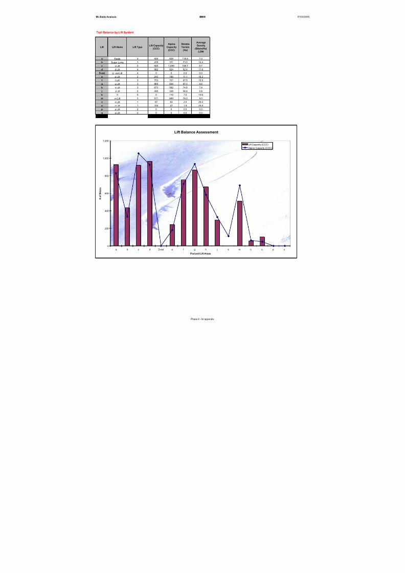
8/12/2019 Mount Baldy
http://slidepdf.com/reader/full/mount-baldy 268/322
Mt. Baldy Analysis BHA 07/03/2005
Trail Balance by Lift System
Lift Lift Name Lift Type Lift Capacity
(CCC)
Alpine
Capacity
(CCC)
Skiable
Terrain
(Ha)
Average
Density
(Skiers/Ha)
LOW
a Eagle 4 926 828 118.4 7.0
b Sugar Lump 3 435 331 23.0 14.4
c c Lift 3 920 1,055 108.7 9.7
d d Lift 4 962 924 52.4 17.6
D-ext d - ext Lift 4 0 0 0.0 0.0
e e Lift 2 243 180 11.1 16.2
f f Lift 3 753 707 67.5 10.5
g g Lift 3 865 934 97.3 9.6
h h Lift 3 673 582 74.8 7.8
j J Lift 2 295 328 56.8 5.8
k 0 0 0 110 7.5 14.6
m m Lift 3 511 689 76.2 9.0
n n Lift 1 57 63 2.5 25.0
o o Lift 1 104 47 1.9 25.0
p p Lift 2 0 0 0.0 0.0
q q Lift 2 0 0 0.0 0.0
Total 6,744 6,778 698 9.71
Lift Balance Assessment
0
200
400
600
800
1,000
1,200
a b c d D-ext e f g h j k m n o p q
Pod and Lift Areas
# o f S
k i e r s
Lift Capacity (CCC)
Alpine Capacity (CCC)
Phase 4 - for appendix
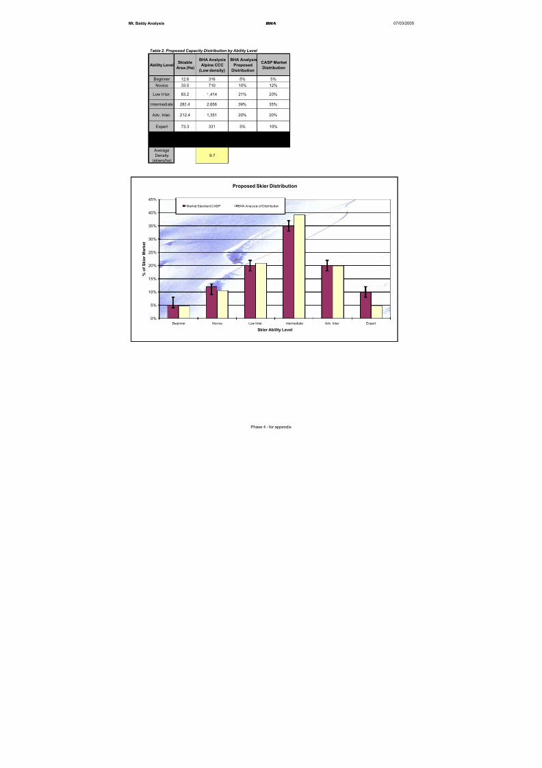
8/12/2019 Mount Baldy
http://slidepdf.com/reader/full/mount-baldy 269/322
Mt. Baldy Analysis BHA 07/03/2005
Table 2. Proposed Capacity Distribution by Ability Level
Ability Level Skiable
Area (Ha)
BHA Analysis
Alpine CCC
(Low density)
BHA Analysis
Proposed
Distribution
CASP Market
Distribution
Beginner 12.6 316 5% 5%
Novice 33.0 710 10% 12%
Low Inter. 83.2 1,414 21% 20%
Intermediate 283.4 2,656 39% 35%
Adv. Inter. 212.4 1,351 20% 20%
Expert 73.3 331 5% 10%
Totals 698.1 6,778 100% 102%
Average
Density
(skiers/ha)
9.7
Proposed Skier Distribution
0%
5%
10%
15%
20%
25%
30%
35%
40%
45%
Beginner Novice Low Inter. Intermediate Adv. Inter. Expert
Skier Ability Level
% o
f S k i e r M a r k e t
Market Standard CASP BHA Analysis of Distribution
Phase 4 - for appendix

8/12/2019 Mount Baldy
http://slidepdf.com/reader/full/mount-baldy 270/322
Addendum to:
Mt. Baldy Resort Expansion Master PlanFebruary, 2005
Addendum Dated December 07th, 2005
Addendum Contains:
Environmental Management PlanWildlife, Riparian, Fish Habitat and Water
Quality Values within the Mt. Baldy SkiHill Proposed Expansion Area
Snowy River Resources Ltd. - November8th, 2005
Update to Final Draft submittedDecember 11, 2004 (Appendix 1)
8/12/2019 Mount Baldy
http://slidepdf.com/reader/full/mount-baldy 271/322
Environmental Management Plan
Wildlife, Riparian, Fish Habitat and Water Quality Values within the
Mt. Baldy Ski Hill Proposed Expansion Area
Prepared for:
Mt. Baldy Ski Corporation
Oliver, BC
Prepared by:
Doug Wahl, MAppSc, RPBio, CPESC
Habitat Biologist
EMP submission timelines: Final draft submitted to responsible authorities for comment: December 11, 2004
Final report submitted: November 8, 2005
SNOWY RIVER RESOURCES LTD.13807 Latimer Ave., Summerland BC V0H 1Z1; Ph: (250) 809-9093 [email protected]
Fish, Wildlife & Habitat Management Regulatory Affairs Monitoring & Audits
8/12/2019 Mount Baldy
http://slidepdf.com/reader/full/mount-baldy 272/322
Snowy River Resources Ltd.
Table of Contents
FOREWORD.....................................................................................................................................1
1.0 INTRODUCTION.......................................................................................................................2
2.0 ECOLOGICAL DESCRIPTION OF THE STUDY AREA....................................................4
3.0 ASSESSMENT OF NATURAL RESOURCE VALUES AND ACTIONS THAT
WILL BE TAKEN TO MITIGATE ENVIRONMENTAL EFFECTS................................4
3.1 Specific Direction for Resource Use Contained in Strategic Land Use Plans .........................4
3.1.1 Okanagan-Shuswap LRMP ..............................................................................................................4
3.1.1.1 High capability marten habitat within the study area ................................................................4
3.1.1.2 Rare forested ecosystems............................................................................................................6
3.1.2 Kootenay-Boundary LRMP..............................................................................................................8
3.2 Old Growth Management Areas ..............................................................................................8
3.3 Wildlife Habitat Areas ...........................................................................................................11 3.4 Ungulate Winter Range..........................................................................................................11
3.5 Rare and Endangered Species................................................................................................11
3.6 Wildlife habitat suitability for elk, mule deer, lynx, Williamson’s sapsucker and white-
headed woodpecker within the study area ...................................................................................15
3.6.1 Methods ..........................................................................................................................................15
3.6.2 Results ............................................................................................................................................16
3.6.2.1 Elk.............................................................................................................................................16
3.6.2.2 Mule Deer.................................................................................................................................17
3.6.2.3 Lynx ..........................................................................................................................................18
3.6.2.4 White-Headed Woodpecker ......................................................................................................19 3.6.2.5 Williamson’s Sapsucker............................................................................................................20
3.7 Bear Management Plan: Minimizing the Potential for Bear-Human Conflicts .....................21
3.8 Water Quality.........................................................................................................................22
3.8.1 McKinney Community Watershed.................................................................................................22
3.8.2 Erosion and sediment control best management practices..............................................................24
3.9 Riparian and Fish Habitat ......................................................................................................24
3.9.1 Status of fish distributions within the study area ............................................................................24
3.9.1.1 Methods ....................................................................................................................................24
3.9.1.2 Results.......................................................................................................................................24
3.9.2 Riparian Management Area Best Management Practices...............................................................25 4.0 SUMMARY AND RECOMMENDATIONS ..........................................................................28
5.0 REFERENCES..........................................................................................................................32
i
8/12/2019 Mount Baldy
http://slidepdf.com/reader/full/mount-baldy 273/322
Snowy River Resources Ltd.
6.0 APPENDICES ...........................................................................................................................33
Appendix 1A: BEC Subzone/Variant Map, Boundary Forest District ........................................33
Appendix 1B: BEC Subzone/Variant Map, Penticton Forest District .........................................34
Appendix 2A: Okanagan-Shuswap LRMP - Resource Management Zones adjacent to the
study area boundary. ....................................................................................................................35 Appendix 2B: E-mail correspondence between Grant Furness, MOE, and Doug Wahl,
Snowy River Resources Ltd., respecting the application of the OSLRMP in regards to
marten habitat. .............................................................................................................................36
Appendix 3A: Planned and approved activities by OGMA within the study area ......................37
Appendix 3B: E-mail correspondence between Frank Wilmer, Senior Planner, MSRM,
Nelson and Doug Wahl, Habitat Biologist, Snowy River Resources Ltd. regarding the
status and management of OGMAs. ............................................................................................42
Appendix 3C: Correspondence from Susan Omelchuck Planner, ILMB, Kamloops
regarding the status and management of OGMAs. ......................................................................46
Appendix 4: Record of e-mail communication between Snowy River Resources Ltd. and
the Conservation Data Centre. .....................................................................................................47
List of Tables
Table 1: OSLRMP strategies within high capability marten habitat and actions proposed bythe MBSC to address the strategies. ..............................................................................................6
Table 2: Analysis of the Kootenay-Boundary LRMP Implementation Strategy objectives
within the B-I01 Kettle-Granby Resource Management Zone. .....................................................9
Table 3: Planned mitigation for rare and endangered species known to occur within or
immediately adjacent to the proposed CRA. ...............................................................................14
Table 4: Habitat rating schemes used elk, mule deer, lynx, Williamson’s sapsucker and white-
headed woodpecker......................................................................................................................15
Table 5: Ecosystem units and structural stages rated at moderate, moderately high, and high
habitat suitability for elk within the study area............................................................................17
Table 6: Ecosystem units and structural stages rated as moderate, moderately high, and high
habitat suitability for mule deer within the study area.................................................................18
Table 7: Ecosystem units and structural stages rated as moderate and high habitat suitability
for lynx within the study area. .....................................................................................................19
Table 8: Reserve Zone and Management Zone widths for streams within a Community
Watershed. ...................................................................................................................................23
Table 9: Riparian Management Area best management practices ....................................................25
Table 10: Vegetation and wildlife habitat resource values within the study area. ............................28 Table 11: Water quality, riparian and fish habitat values within the study area ...............................30
ii

8/12/2019 Mount Baldy
http://slidepdf.com/reader/full/mount-baldy 274/322
Snowy River Resources Ltd.
List of Figures
Figure 1: Location of Mt. Baldy ski area, the study area boundary, the CRA boundary and the
McKinney Community Watershed boundary. ...............................................................................3
Figure 2: High capability marten habitat within the study area and the Mt. Baldy CRA. ..................5
Figure 3: Location of RFEs within and adjacent to planned development activities..........................7
Figure 4: Location of draft OGMAs established within the Kootenay and Kamloops ILMB
Regions. .......................................................................................................................................10
Figure 5: Alpine Sorrel ( Rumex paucifolius) ....................................................................................13
Figure 6: Brewer’s Monkeyflower ( Mimulus breweri).....................................................................13
Figure 7: Lemmon’s Holly Fern ( Polystichum lemmonii) ................................................................13
Figure 8: Actual and extrapolated high habitat suitability polygons within the study area
boundary. .....................................................................................................................................20
Figure 9: McKinney Community Watershed boundary....................................................................23
Figure 10: Status of known fish distributions within the study area. ................................................26
Figure 11: Fish distribution for McKinney Creek.............................................................................27
iii
8/12/2019 Mount Baldy
http://slidepdf.com/reader/full/mount-baldy 275/322
8/12/2019 Mount Baldy
http://slidepdf.com/reader/full/mount-baldy 276/322
Snowy River Resources Ltd.
1.0 INTRODUCTION
This environmental management plan (EMP) provides a detailed assessment of natural resource
values within and immediately adjacent to the study area boundary and the proposed Controlled
Recreation Area [CRA]) for Mt. Baldy Ski Hill expansion project (Figure 1). Recommendations
and suggested actions for integrating planned development in a manner that adequately mitigates potential impacts are also included.
From initial concept to final design, the intent of the Mt. Baldy Ski Corporation (MBSC) has been
to develop a base area plan and associated infrastructure that reflects the type, quality, quantity and
sensitivity of natural resource values. Prior to commencing the development of the plan, however,
little information regarding fish and wildlife habitats was available to guide planning activities.
On June 25th, 2004, the MBSC and Brent Harley and Associates met with several government
agencies including the Ministry of Environment (MOE), in part, to obtain guidance and advice on
managing identified resource values within the study area.
To further assess the potential natural resource values, and to develop appropriaterecommendations for incorporation into the Master Development Plan, the MBSC sought
additional guidance and advice from a Registered Professional Biologist. The scope of the services
provided by the Biologist (Snowy River Resources Ltd.) included:
1. an assessment of applicable legislation including the Wildlife Act , Migratory Birds
Regulations, Water Act , Fisheries Act , Species at Risk Act and the Forest and Range
Practices Act ;
2. an assessment of relevant strategic plans, including the Okanagan-Shuswap Land and
Resource Management Plan (OSLRMP) and the Kootenay Boundary Land and Resource
Management Plan (KBLRMP);
3. an assessment and incorporation of other related legislative and policy initiatives that may
not legally apply to this tenure application but may have components that warrant furtherconsideration and incorporation. These initiatives include Ungulate Winter Range (UWR),
the Identified Wildlife Management Strategy (IWMS) and the Old Growth Management
Strategy all of which are policy initiatives implemented under the Forest and Range
Practices Act ;
4. an assessment of resource information databases maintained by government as well as
local forest licencees;
5. communication with Integrated Land Management Bureau (ILMB) Planners, species
specialists with the Conservation Data Centre (CDC), Ministry of Environment (MOE)
Biologists, Ecosystems Officers and other independent biologists and species specialists;
6. completion of a habitat suitability assessment, fish inventory assessment and bear
management plan; and,
7. consideration and incorporation of published and draft Best Management Practices (BMPs)
authored by government and industry.
2

8/12/2019 Mount Baldy
http://slidepdf.com/reader/full/mount-baldy 277/322
Snowy River Resources Ltd.
Figure 1: Location of Mt. Baldy ski area, the study area boundary, the CRA boundary and
the McKinney Community Watershed boundary.
Osoyoos, BC
Hwy. 3
Bridesville, BC
McKinney Community
Watershed boundary.
Mt. Baldy Ski Hill studyarea boundary.
3
8/12/2019 Mount Baldy
http://slidepdf.com/reader/full/mount-baldy 278/322
Snowy River Resources Ltd.
2.0 ECOLOGICAL DESCRIPTION OF THE STUDY AREA
The study area (Figure 1) is located within the North Okanagan Highland Ecosection (NOH) and
the Englemann spruce – subalpine fir (ESSF) and Montane Spruce (MS) biogeoclimatic zones.
Much of the proposed development is within the dry, cold Okanagan variant of the Englemann
spruce - subalpine fir biogeoclimatic subzone (ESSFdc1). The remaining portion of the proposeddevelopment, within the ESSF, is comprised of the Okanagan dry cold Englemann spruce –
subalpine fir upper elevation biogeoclimatic subzone (ESSFdcu); and higher elevation
(approximately 2,000m asl) parkland variant (ESSFdcp1) of the ESSF dc1 subzone. The lower
portion of the development area (below 1,600 m asl) lies entirely within the Okanagan dry mild
montane spruce biogeoclimatic subzone (MSdm1)(see Appendix 1A and 1B for a map of BEC
subzones/variants within the Boundary Forest District and the Penticton Forest District
respectively). The study area encompasses the McKinney Community Watershed (Figure 1), which
drains into Rock Creek and also includes portions of other drainages including Coteay Creek,
Gregoire Creek, Underdown Creek, McIntyre Creek, Wapiti Creek and Rice Creek.
3.0 ASSESSMENT OF NATURAL RESOURCE VALUES AND ACTIONS
THAT WILL BE TAKEN TO MITIGATE ENVIRONMENTAL EFFECTS
3.1 Specific Direction for Resource Use Contained in Strategic Land Use Plans
The OSLRMP and KBLRMP are strategic Crown land-use plans which set objectives and specific
targets for land use activities, such as resource extraction (forestry and mining), recreation and
range use. The content of the Okanagan-Shuswap LRMPs is not legally binding but is generally
considered by Crown land tenure holders. Components of the KBLRMP are legally binding as they
have been declared a Higher Level Plan under the Forest Practices Code of BC Act .
Where practicable, efforts will be made by the MBSC to conform to the spirit and intent of the
LRMPs. As part of preparing this EMP, the content of the plans were reviewed to identify resource
objectives, development constraints or considerations that may apply within the study area.
Assistance with the interpretation of plan content was sought from the ILMB and the MOE.
3.1.1 Okanagan-Shuswap LRMP
The proposed study area is located on the eastern edge of the OSLRMP boundary. The boundary
follows the height of land of Mt. Baldy but excludes any part of the Rock Creek watershed. There
are few specific references, Resource Management Zones (RMZs) or other biodiversity values
identified in the OSLRMP that are directly applicable to study area (see Appendix 2a). However,the OSLRMP does identify the potential occurrence of high capability marten habitat within the
CRA as well as measures to protect rare forest ecosystems.
3.1.1.1 High capability marten habitat within the study areaDuring agency review of the EMP, the MOE notified the MBSC that a portion of the study area
may be mapped as high capability marten habitat as per the OSLRMP. The ILMB provided the
high capability marten habitat map to the MBSC to determine the extent of overlap with the studyarea and the CRA boundary.
The high capability marten habitat map provided by the MOE (Figure 2) extends beyond the
boundary of the OSLRMP, into the boundary of the KBLRMP. The undersigned assumes that the
4
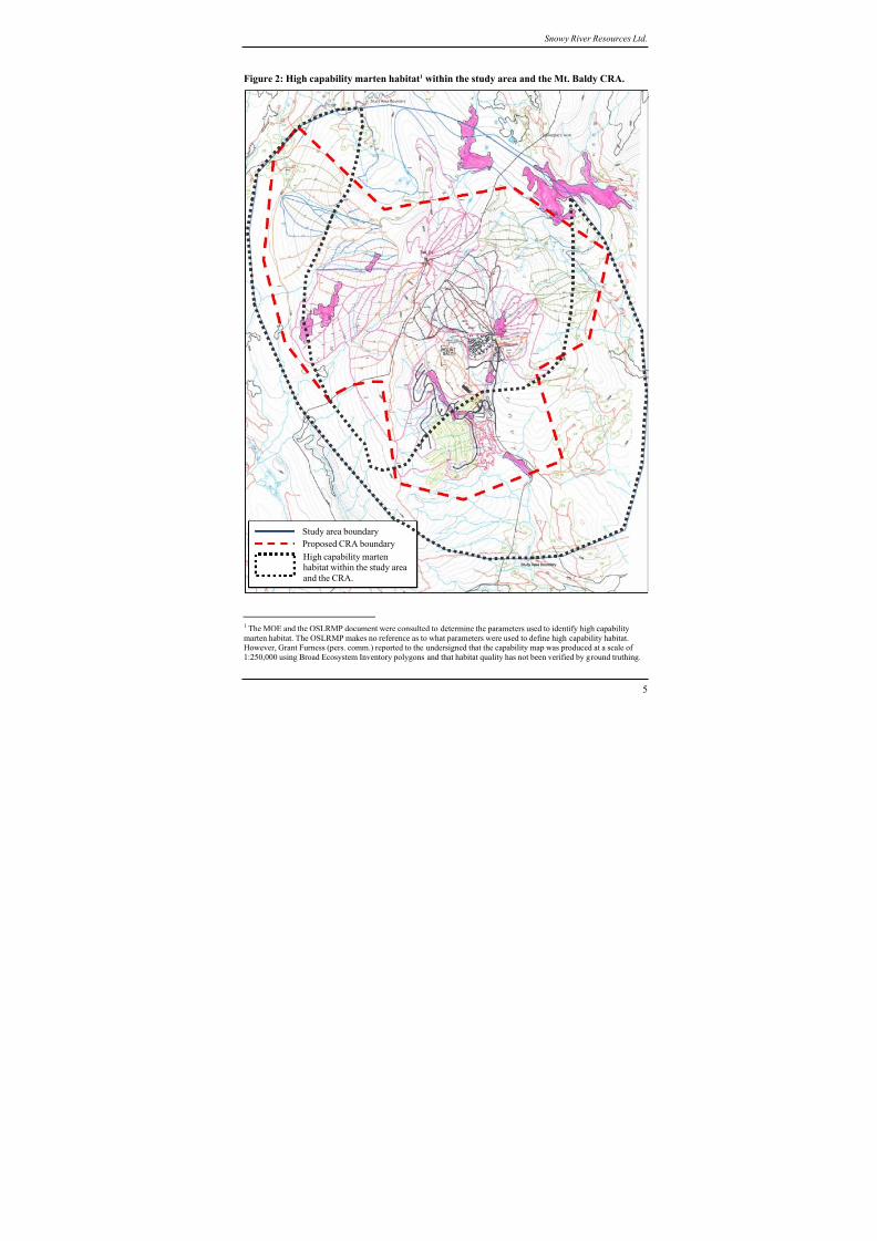
8/12/2019 Mount Baldy
http://slidepdf.com/reader/full/mount-baldy 279/322
8/12/2019 Mount Baldy
http://slidepdf.com/reader/full/mount-baldy 280/322
Snowy River Resources Ltd.
MOE first developed the high capability map for the entire Okanagan Region and the relevant part
of that map was included in the OSLRMP. As the KBLRMP makes no references to marten
habitat, the MBSC will adopt the strategies contained in the OSLRMP for the high capability
marten habitat in the Kootenay Region of the study area.
The OSLRMP (General Resource Management Zone - Wildlife [page 3-10]) identifies severalstrategies for the maintenance and enhancement of marten habitat. However, several strategies are
directed specifically at forest practices, including the retention of wildlife tree patches within
cutblocks. Two strategies within the OSLRMP for marten habitat are related to the planned
development activities. The two strategies and corresponding actions to be taken by the MBSC are
presented in Table 12:
Although not specified in the OSLRMP, the MBSC will ensure that active marten dens are
protected from any activities under it’s control. Ski runs, ski lifts and other infrastructure will be
located away from any known den site.
Table 1: OSLRMP strategies within high capability marten habitat and actions proposed by
the MBSC to address the strategies.
Reference
OSLRMP
OSLRMP strategy Actions proposed by the MBSC within
high capability marten habitat (as per
Figure 3)
Section 7.2, page
Wildlife 3-11:
Plan for connectivity during landscape
unit planning, utilizing temporal and
spatial distribution of cut and leaveareas, old growth management areas,
wildlife tree patches, and enhanced
riparian protection.
The MBSC will maintain connectivity
corridors with an emphasis placed on
enhanced retention of riparian habitat. Skiruns, ski lifts and other access trails will
most often cross perpendicular to riparian
corridors. To the extent practicable, the
MBSC will plan the location of suchfacilities away from riparian habitat.
Section 7.5, pageWildlife 3-11: In high capability marten habitats as per the “High Capability Marten
Habitat” map, retain “enhanced” levels
of coarse woody debris along riparianmanagement areas (RMA) that do not
have a reserve. This is only required on
one RMA per 40 hectares of harvest
area.
The MBSC will maintain enhanced levelsof CWD in two ways: 1) during the
installation of ski runs, the Company will
directionally fall timber into the riparianarea provided that the no part of the felled
tree will reach a stream; and, 2) provided
that it is safe to do so (i.e. safe for skiers),
we will strategically locate debris piles
along riparian areas to promote denningopportunities for marten.
3.1.1.2 Rare forested ecosystems
During their review of the draft EMP, the MOE requested that the revised EMP address rare
forested ecosystems (RFEs) that may be located within the CRA. At the request of the MBSC, the
ILMB produced a map showing the location of rare forest types within the CRA (Figure 3 and 4).
Within the Kamloops Region of the ILMB, RFEs were delineated using forest cover mapping and
used as one of several criteria for selecting candidate OGMAs (Frank Rowe, pers. comm.). As the
amount of OGMAs selected was limited to a percentage of the Timber Harvesting Land Base, there
2 The strategies for marten habitat contained in Table 1 were endorsed by the MOE (see Appendix 2B).
6

8/12/2019 Mount Baldy
http://slidepdf.com/reader/full/mount-baldy 281/322
Snowy River Resources Ltd.
were a number of RFEs that were not captured within OGMAs (this is case for several rare forest
ecosystems within the study area which are not delineated as OGMAs).
While the ILMB provides no guidance on management practices within RFEs (Grant Furness, pers.
comm.), the OSLRMP does state several strategies and objectives for forest ecosystem
management, including RFEs (General Resource Management Zone – Ecosystem Management -Forests [page EMFOREST 3-4]). These objectives include avoiding disturbances to rare
ecosystems by:
1) minimizing new road construction [or other industrial resulting in similar disturbance],
2) assessing each rare ecosystem and determine the limitations or impediments to ecosystem
function as a result of human interference. Develop a plan to remove, or significantly
reduce, the interference to better allow the ecosystem to develop the desired structural
characteristics and function in as close to a natural state as possible (e.g., noxious weed
removal, understorey burns, road rehabilitation, etc.).
The undersigned has carefully examined the mapped RFEs (not already included as OGMAs) and
suggests that the planned development activities will not likely have an adverse effect on their
integrity and function (see Figure 3 and 4 which shows the mapped RFEs and the planned location
of ski hill infrastructure). However, to ensure that disturbance of the RFEs is minimized, the
MBSC proposes to undertake site-level assessments where development activities are planned
within a mapped RFE polygon. The purpose of the assessment will be to verify the RFE, to
determine the extent of impact of planned development and to identify appropriate mitigation
strategies.
It is the opinion of the undersigned that the approach adopted by the MBSC with respect to
assessment and management of RFEs is consistent with the intent of the OSLRMP.
Figure 3: Location of RFEs within and adjacent to planned development activities
CRA
CRA
Note: this map shows that there are few
planned incursions into the mapped RFEs.
Rare forest ecosystems (RFEs)
7
8/12/2019 Mount Baldy
http://slidepdf.com/reader/full/mount-baldy 282/322
Snowy River Resources Ltd.
3.1.2 Kootenay-Boundary LRMP
This LRMP boundary includes the much of the study area including the base area with the
exception of Mt. Baldy, which lies partially within the OSLRMP boundary. The planned
development within the study area is consistent with resource management direction specified
within the Kootenay-Boundary Higher Level Order (2002) and the KBLRMP Implementation
Strategy (1997)3 (Table 2).
3.2 Old Growth Management Areas
On June 30, 2004, the Minister of Sustainable Resource Management (now referred to as the
Integrated Land Management Bureau) issued an Order 4, pursuant to the Forest Practices Code of
BC Act , legally establishing provincial non-spatial old growth objectives. The Order establishes the
amount of old forest that will be maintained to address biodiversity values across the province and
applies to any “forest licensee5”.
Although the Mt. Baldi Ski Hill expansion is not directly subject to the Order, the MBSC has
undertaken extensive consultations with the ILMB (Kootenay and Kamloops Regions) to determine
the status of Old Growth Management Areas (OGMAs) within the study area. As a result, it wasdetermined by the ILMB that nine (9) draft OGMAs were located either partially or entirely within
the study area. By cross-referencing the location of the 9 draft OGMAs with planned ski lifts, ski
runs and associated infrastructure, the MBSC determined that approximately 10.7% of the total
area (17.22ha.) of draft OGMAs would require modification in the form of clearing (Figure 4 and
Appendix 3A).
By request of the MBSC, the ILMB (Kootenay Region) have approved planned modification
activities and have agreed to eliminate OGMA #39 entirely (Frank Wilmer, ILMB, in
communication by e-mail with Doug Wahl [Appendix 3B]. The ILMB (Kamloops Region) have
also been notified regarding the planned modification activities within 3 draft OGMAs and have
responded that two OGMAs will not be adversely affected. A third OGMA will be adversely
affected, therefore, the ILMB will identify alternate old growth patches in the area (SusanOmelchuk, ILMB, in communication with Doug Wahl [Appendix 3C]).
The MBSC fully supports government’s initiative to protect old growth and will make every effort
to ensure the integrity of these features within the existing base area and planned expansion area.
However, the MBSC will not assume legal responsibility in the event that approved clearing
triggers windthrow within the OGMA. Prior to commencing forest clearing within an OGMA, the
MBSC will review the Ministry of Forests e-learning web site on windthrow6. The MBSC will also
report any significant amount of windthrow within an OGMA to the ILMB.
3 Source: http://srmwww.gov.bc.ca/kor/rmd/kblup/toc.htm.4 http://srmwww.gov.bc.ca/rmd/oldgrowth/nonspatial-old-growth.htm.5 The Order defines a licensee as “a party required to prepare a forest development plan under the Forest Practices Codeof BC Act or a forest stewardship plan under the Forest and Range Practices Act . 6 http://www.for.gov.bc.ca/HFP/FORDEV/windthrow
8
8/12/2019 Mount Baldy
http://slidepdf.com/reader/full/mount-baldy 283/322
Snowy River Resources Ltd.
Table 2: Analysis of the Kootenay-Boundary LRMP Implementation Strategy objectives
within the B-I01 Kettle-Granby Resource Management Zone7.
LRMP
Objective
LRMP Implementation Strategy Actions required by the MBSC to meet the
intent of the strategy
General
Biodiversity
Retain forest and grassland ecological
elements and processes, includingspecies richness, distribution and
diversity at a moderate to basic
stewardship level.
Based on the results of this environmental
assessment, it is the opinion of theundersigned that the proposed expansion of
Mt. Baldy represents an overall low risk of
impact to species richness, distribution anddiversity.
Maintain the regional connectivity
corridors.
The proposed study area does not conflict
with connectivity corridors established by the
LRMP.
Retain attributes for old growth
dependent species and fur bearers.
With minor modification (approved by
ILMB), the MBSC will maintain old growth
values.
Ensure habitat requirements for Red and
Blue-listed and regionally significant
species are achieved.
There are no known Red or Blue-listed fish or
wildlife within the study area. However, Red
and Blue-listed plant species have been
identified. No regionally significant species or
WHAs have been identified by MOE as aconcern within the study area.
Ungulates Maintain the abundance of regionally
significant mule and white-tailed deer,
elk and moose within the sustainablecarrying capacity of their habitat.
Maintain the priority summer habitat
within this unit through application ofthe biodiversity emphasis under the
FPC.
No part of the study area is located within
ungulate winter range as established by
government (Frank Wilmer 8 and GrantFurness9, pers. comm.). The ESSFdcp1 was
mapped by the undersigned as providing high
suitability elk foraging habitat (during the
growing season). The proposed development
will not likely affect elk habitat use orsuitability (Brian Harris, pers. comm.). (Note:
section 3.6.2.1 describes threshold-basedmanagement actions that will be adopted by
the MBSC).
Wide ranging
Carnivores
Maintain sufficient habitat in the
northeast half of the unit (the area
running from the Copper Kettle to the
community of Grand Forks), to restore,maintain or enhance grizzly bear
populations.
Not applicable - the LRMP does not show the
study area as grizzly bear habitat.
Ensure the existing marten populations
are maintained or enhanced.
The proposed development will not likely
affect marten populations.
Fisheries Maintain wild fish stocks and habitat forRainbow Trout, Mountain Whitefish and
Brook Trout
As described in this document, the proposedexpansion will not likely affect fish habitat
values.
7 The entire Mt. Baldy base area is located within the plan area of the KBLRMP. Therefore, the content of this plan, as
opposed to the OSLRMP, was used in this assessment.8 Frank Wilmer, Senior Planner, ILMB, Nelson.9 Grant Furness, Ecosystems Biologist, MOE, Penticton.
9
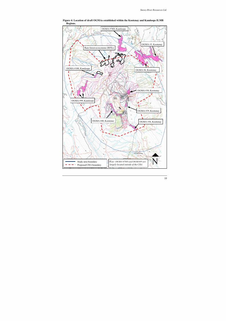
8/12/2019 Mount Baldy
http://slidepdf.com/reader/full/mount-baldy 284/322
Snowy River Resources Ltd.
Figure 4: Location of draft OGMAs established within the Kootenay and Kamloops ILMB
Regions.
ote: OGMA #78D and OGMA#5 are
largely located outside of the CRA.
OGMA #40, Kootenay
OGMA #99, Kamloops
OGMA #100, Kamloops
Rare forest ecosystems (RFEs)
OGMA #6, Kootenay
OGMA #30, Kootenay
OGMA #39, Kootenay
OGMA #56, Kootenay
Proposed CRA boundary
Study area boundary
OGMA #5, Kootenay
OGMA #78D, Kamloops
10
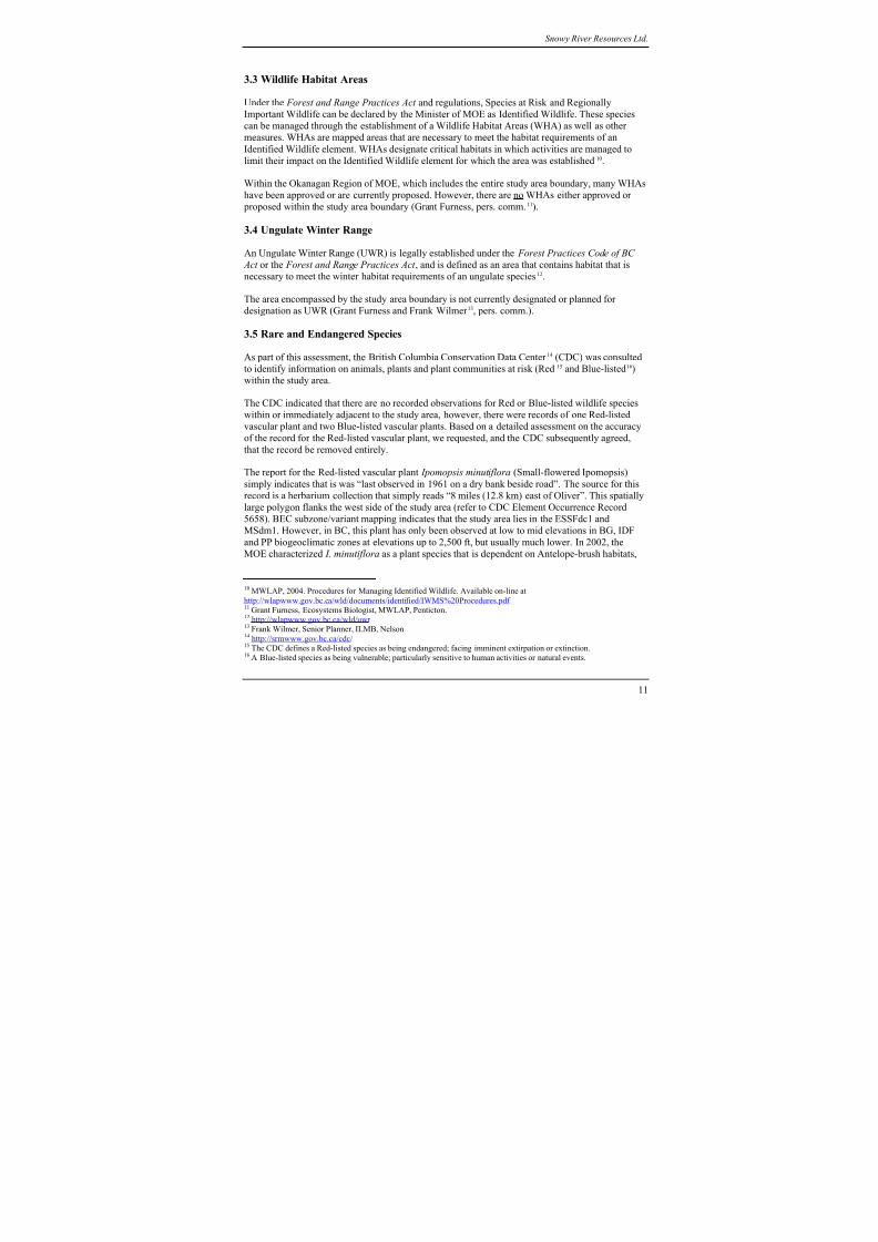
8/12/2019 Mount Baldy
http://slidepdf.com/reader/full/mount-baldy 285/322
Snowy River Resources Ltd.
3.3 Wildlife Habitat Areas
Under the Forest and Range Practices Act and regulations, Species at Risk and Regionally
Important Wildlife can be declared by the Minister of MOE as Identified Wildlife. These species
can be managed through the establishment of a Wildlife Habitat Areas (WHA) as well as other
measures. WHAs are mapped areas that are necessary to meet the habitat requirements of anIdentified Wildlife element. WHAs designate critical habitats in which activities are managed to
limit their impact on the Identified Wildlife element for which the area was established10.
Within the Okanagan Region of MOE, which includes the entire study area boundary, many WHAs
have been approved or are currently proposed. However, there are no WHAs either approved or
proposed within the study area boundary (Grant Furness, pers. comm.11).
3.4 Ungulate Winter Range
An Ungulate Winter Range (UWR) is legally established under the Forest Practices Code of BC
Act or the Forest and Range Practices Act , and is defined as an area that contains habitat that is
necessary to meet the winter habitat requirements of an ungulate species
12
.
The area encompassed by the study area boundary is not currently designated or planned for
designation as UWR (Grant Furness and Frank Wilmer 13, pers. comm.).
3.5 Rare and Endangered Species
As part of this assessment, the British Columbia Conservation Data Center 14 (CDC) was consulted to identify information on animals, plants and plant communities at risk (Red15 and Blue-listed16)
within the study area.
The CDC indicated that there are no recorded observations for Red or Blue-listed wildlife species
within or immediately adjacent to the study area, however, there were records of one Red-listed
vascular plant and two Blue-listed vascular plants. Based on a detailed assessment on the accuracy
of the record for the Red-listed vascular plant, we requested, and the CDC subsequently agreed,
that the record be removed entirely.
The report for the Red-listed vascular plant Ipomopsis minutiflora (Small-flowered Ipomopsis)
simply indicates that is was “last observed in 1961 on a dry bank beside road”. The source for this
record is a herbarium collection that simply reads “8 miles (12.8 km) east of Oliver”. This spatially
large polygon flanks the west side of the study area (refer to CDC Element Occurrence Record
5658). BEC subzone/variant mapping indicates that the study area lies in the ESSFdc1 and
MSdm1. However, in BC, this plant has only been observed at low to mid elevations in BG, IDF
and PP biogeoclimatic zones at elevations up to 2,500 ft, but usually much lower. In 2002, the
MOE characterized I. minutiflora as a plant species that is dependent on Antelope-brush habitats,
10 MWLAP, 2004. Procedures for Managing Identified Wildlife. Available on-line at
http://wlapwww.gov.bc.ca/wld/documents/identified/IWMS%20Procedures.pdf 11 Grant Furness, Ecosystems Biologist, MWLAP, Penticton.12 http://wlapwww.gov.bc.ca/wld/uwr 13 Frank Wilmer, Senior Planner, ILMB, Nelson14 http://srmwww.gov.bc.ca/cdc/ 15 The CDC defines a Red-listed species as being endangered; facing imminent extirpation or extinction.16 A Blue-listed species as being vulnerable; particularly sensitive to human activities or natural events.
11
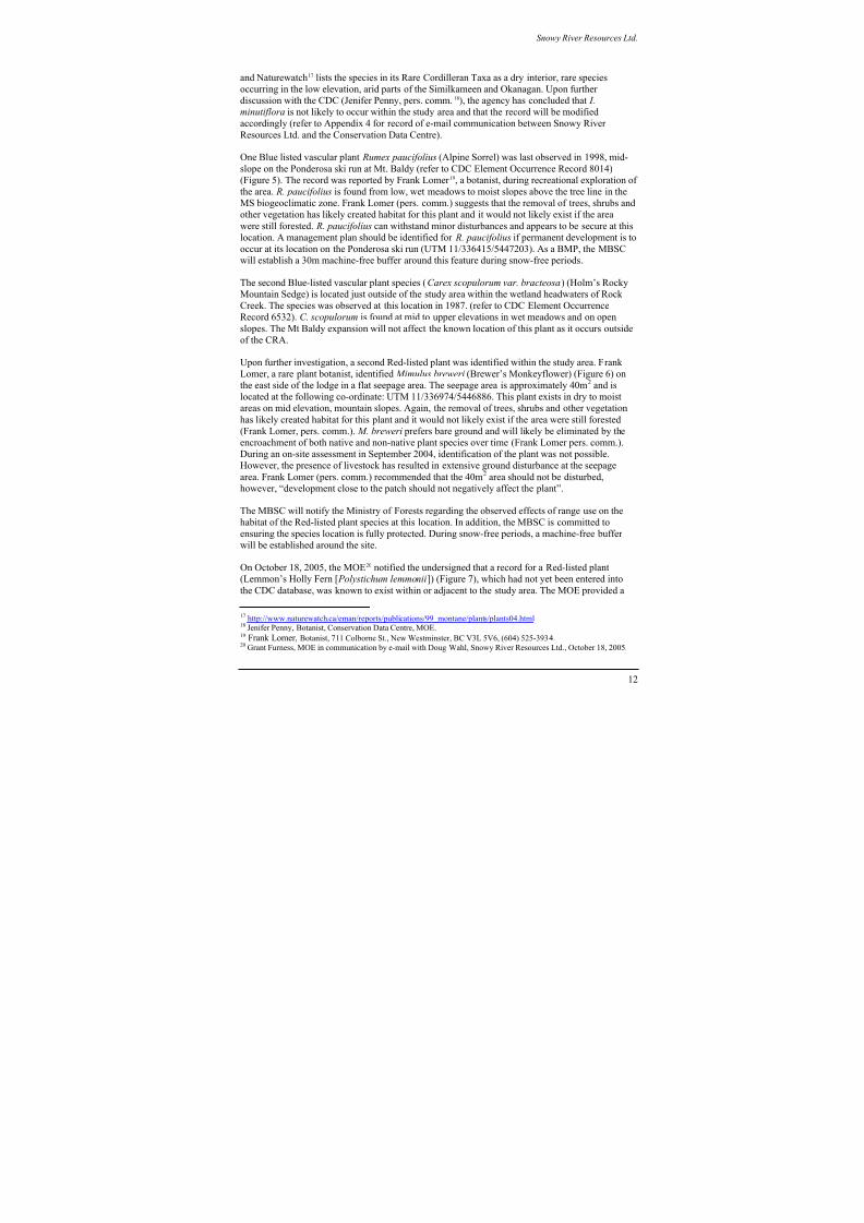
8/12/2019 Mount Baldy
http://slidepdf.com/reader/full/mount-baldy 286/322
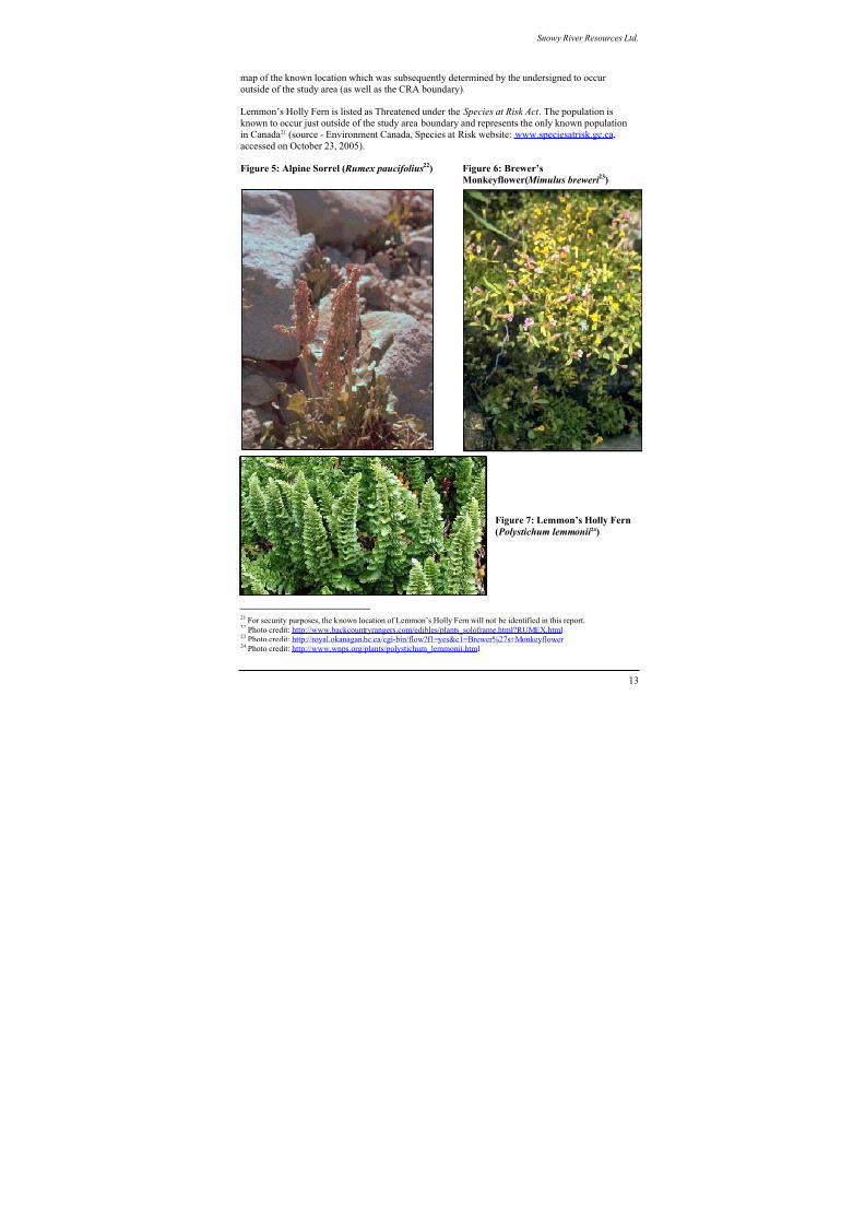
8/12/2019 Mount Baldy
http://slidepdf.com/reader/full/mount-baldy 287/322
Snowy River Resources Ltd.
map of the known location which was subsequently determined by the undersigned to occur
outside of the study area (as well as the CRA boundary).
Lemmon’s Holly Fern is listed as Threatened under the Species at Risk Act . The population is
known to occur just outside of the study area boundary and represents the only known population
in Canada21
(source - Environment Canada, Species at Risk website: www.speciesatrisk.gc.ca,accessed on October 23, 2005).
Figure 5: Alpine Sorrel ( Rumex paucifolius22) Figure 6: Brewer’s
Monkeyflower( Mimulus breweri 23)
Figure 7: Lemmon’s Holly Fern
( Polystichum lemmonii 24)
21 For security purposes, the known location of Lemmon’s Holly Fern will not be identified in this report.22 Photo credit: http://www.backcountryrangers.com/edibles/plants_soloframe.html?RUMEX.html 23 Photo credit: http://royal.okanagan.bc.ca/cgi-bin/flow?f1=yes&c1=Brewer%27s+Monkeyflower 24 Photo credit: http://www.wnps.org/plants/polystichum_lemmonii.html
13

8/12/2019 Mount Baldy
http://slidepdf.com/reader/full/mount-baldy 288/322
Snowy River Resources Ltd.
3.5.1: Summary of management strategies for rare and endangered species
The MBSC recognizes the importance of conserving rare and endangered species. As such, the
Company will make every attempt to ensure that all activities under it’s direct control will prevent,
either directly or indirectly, any impacts to known populations as described in this EMP as well as
new occurrences that we are made aware of. The MBSC also assumes that there is a potential for
the listed species to occur elsewhere within the study area, as the number of known locations islikely limited by survey effort.
For the known locations of Alpine Sorrel and Brewer’s Monkeyflower, which occur with the
proposed CRA, the Company has developed a mitigation strategy in consultation with species
specialists and the CDC. For these two species, as well as Holm’s Rocky Mountain Sedge and
Lemmon’s Holly Fern, the Company will also undertake reconnaissance surveys in preferred
habitats, prior to ground disturbance, as required for the development of ski hill infrastructure (see
Table 3). Where new locations are identified and verified, the MBSC will notify the CDC and
prepare a mitigation strategy to ensure that the populations are not adversely affected by activities
under it’s control. The MOE will be consulted on any actions taken to protect known populations.
It is the opinion of the undersigned that the planned strategy for the protection of known populations of rare and endangered species is consistent with the relevant direction specified in the
OSLRMP and KBLRMP.
Table 3: Planned mitigation for rare and endangered species known to occur within or
immediately adjacent to the proposed CRA.
Species Known record
within or adjacent
to CRA
Conservation status Management strategy
Alpine Sorrel Within CRA BC: Blue-listed (CDC) • Establish a 30m machine-free buffer
around the known location during
snow-free periods.
• Complete reconnaissance survey prior
to construction of ski hillinfrastructure if preferred habitat is
likely to be altered.
Holm’s Rocky
Mountain
Sedge
Adjacent to CRA BC: Blue-listed (CDC) • Complete reconnaissance survey prior
to construction of ski hill
infrastructure if preferred habitat is
likely to be altered.
Brewer’s
MonkeyflowerWithin CRA BC: Red-listed (CDC) • Delineate and protect known location.
Identify resource values with rangetenure holder and the MOF.
• Complete reconnaissance survey prior
to construction of ski hillinfrastructure if preferred habitat islikely to be altered.
Lemmon’s
Holly FernAdjacent to CRA BC: Red-listed (CDC)
Federal: Threatened
(SARA)
• Complete reconnaissance survey prior
to construction of ski hillinfrastructure if preferred habitat is
likely to be altered.
14

8/12/2019 Mount Baldy
http://slidepdf.com/reader/full/mount-baldy 289/322
Snowy River Resources Ltd.
3.6 Wildlife habitat suitability for elk, mule deer, lynx, Williamson’s sapsucker and
white-headed woodpecker within the study area
The primary data source consulted to derive habitat suitability information for this assessment was
Terrestrial Ecosystem Mapping (TEM) with Wildlife Habitat Suitability25 Interpretations completed
for Weyerhaeuser TFL 15, Okanagan Falls Division. The document used has three volumes:Volume I: Terrestrial Ecosystem & Bioterrrain Mapping with Expanded Legends for Terrestrial
Ecosystem Units; Volume II: Wildlife Species Profiles (Accounts26) and Habitat Models; and
Volume III: Wildlife Habitat Ratings Tables (Geowest, 2000)27. Wildlife habitat evaluation was
completed in TFL 15 for the white-headed woodpecker ( Picoides albolarvatus), Williamson’s
sapsucker (Sphyrapicus thyroideus), Canada lynx ( Lynx canadensis), mule deer (Odocoileus
hemionus), and elk (Cervus elaphus). Species accounts, habitat ratings and the accompanying maps
depicting habitat suitability ratings for these five wildlife species were used to complete this
assessment.
3.6.1 Methods
Wildlife interpretations were extrapolated to the unmapped portion of the proposed development
location using Biogeoclimatic Ecosystem Classification, TRIM, and forest cover mapping alongwith aerial photographs. The methodology used to identify ecosystem units is similar to that for
TEM, with the exception that air photos are not pre-typed for bioterrain features and the site series
units were not ground truthed. Mapping is based on vegetation types rather than on bioterrain
polygons.
Forest cover labels were used to determine structural stage and broad site series classifications.There was no habitat or vegetation mapping available for the study area. Site series units in the
study area were identified using the Ministry of Forests field guide for the Kamloops Forest Region
(Lloyd et al. 1990).
Rating schemes are based on the level of knowledge of a species use of available. For species
where there is a high level of knowledge (e.g. for this project, elk and mule deer) a 6-class ratingsscheme is employed. For other species where there is a moderate level of knowledge (e.g. for this
project, lynx, white-headed woodpecker, and Williamson’s sapsucker), a 4-class ratings scheme
was used (Table 4).
Table 4: Habitat rating schemes used elk, mule deer, lynx, Williamson’s sapsucker and white-
headed woodpecker.
% of Provincial
Best
High Knowledge of Habitat Use
(6-class for elk & mule deer)
Moderate Knowledge of Habitat Use
(4-class for lynx, Williamson’s sapsucker
and white-headed woodpecker)
Rating Code Rating Code
100 - 76% High 1 High H75 - 51% Moderately High 2 Moderate M
25 Habitat suitability is used to identify the current ability of an ecosystem unit to provide a given wildlife species with itslife requisites, or the environmental conditions needed for cover, food, and space.26 Each species account (profiles) presents the ecology and life requisites for the species, along with assumptions used in
assigning habitat suitability ratings. Preliminary habitat suitability ratings for each species were hypothesized ratings based on the habitat relationships described in the species profile.27 Available on-line at ftp://ftp.env.gov.bc.ca/dist/wis/tem/warehouse/region_3/okanagan_falls
15
8/12/2019 Mount Baldy
http://slidepdf.com/reader/full/mount-baldy 290/322
Snowy River Resources Ltd.
Table 4 cont’d: Habitat rating schemes used elk, mule deer, lynx, Williamson’s sapsucker
and white-headed woodpecker.
% of Provincial
Best
High Knowledge of Habitat Use
(6-class for elk & mule deer)
Moderate Knowledge of Habitat Use
(4-class for lynx, Williamson’s sapsucker
and white-headed woodpecker)
50 - 26% Moderate 3
25 - 6% Low 4
5 – 1% Very Low 5
Low L
0% Nil 6 Nil N
3.6.2 Results
The following sections summarize the results of TEM Wildlife Interpretations prepared for TFL 15
as well as surrogate mapping completed for portions of the study area where TEM had not been
completed.
3.6.2.1 ElkElk habitat suitability within and adjacent to the study area in the ESSFdc1 and ESSFdcu
biogeoclimatic subzones, is generally rated as low for forage and security/thermal cover in the
winter, and moderate for both forage and security thermal cover during the growing seasons
(spring, summer and fall) (Table 5). The dry cold Engelmann Spruce Subalpine Fir (ESSFdc1)
biogeoclimatic subzone, occurs at an elevation of 1,600-1,800 m. Dominant vegetation consists of
mixed mature seral stands of lodgepole pine, Engelmann spruce and subalpine fir. Understorey is
dominated by grouseberry, Sitka valerian, five-leaved bramble and trapper’s tea. These plant
associations typically provide very limited elk foraging opportunities during the summer/fall and
snow depths restrict winter use.
There is a small portion of alpine sedge, alpine fescue, and herbaceous meadow habitat found in
the upper elevation parkland variant of the ESSFdc1 (Polygon # 1, Figure 8). These habitats arefound at approximately 2,200m asl and have been rated high for elk foraging in all seasons
(Geowest 2000). Alpine sedge, alpine fescue and herbaceous meadow habitat types provide
excellent opportunities for elk feeding year round. However, it is unlikely that elk use this habitat
in winter months due to the high elevation and the distance to other suitable winter habitat in the
area. The species model for elk in TFL 15 (Geowest 2000) indicates that elk winter habitat is
restricted to elevations less than 1,400m. For this reason we have not mapped these habitat
associations as high for winter feeding suitability.
There are no known government records of elk use within the study area boundary (Orville Dyerand Brian Harris, pers. comm.28) and no elk have been sighted on or near Mt. Baldy by ski hill staff
(Tim Foster, pers. comm.29) The proposed development will not likely affect elk habitat use or
suitability (Brian Harris, pers. comm.). Nonetheless, the MBSC supports the MOEsrecommendation (Brian Harris, pers. comm.) that a Qualified Professional should assess elk habitat
use in the ESSFdcp1 once a threshold of >500 person days/month of use is exceeded during June-October.
28 Orville Dyer and Brian Harris, Wildlife Biologists, MWLAP, Penticton.29 Tim Foster, General Manager, Mt. Baldy Ski Corporation
16
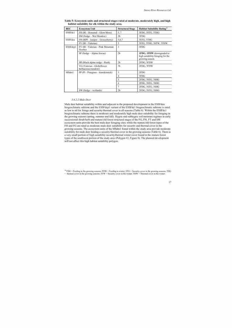
8/12/2019 Mount Baldy
http://slidepdf.com/reader/full/mount-baldy 291/322
Snowy River Resources Ltd.
Table 5: Ecosystem units and structural stages rated at moderate, moderately high, and high
habitat suitability for elk within the study area.
BEC Ecosystem Unit Structural Stage Habitat Suitability Rating30
FH (Bl – Horsetail – Glow Moss) 5, 7 3FDG, 3STG, 3THGESSFdc1
SM (Sedge – Wet Meadow) 2b 3FDGFH (BlPl – Juniper – Grouseberry) 5,6,7 3STG, 3THGESSFdcu
FV (Bl – Valerian) 5 3STG, 3THG, 3STW, 3THW
FV (Bl – Valerian – Pink MountainHeather
3 3FDG
SF (Sedge – Alpine fescue) 2b 1FDG, 1FDW (downgraded to
high suitability foraging for thegrowing season.
SR (Black alpine sedge – Rush) 2b 2FDG, 3FDW
ESSFdcp1
VG (Valerian – Globeflower
herbaceous meadow)
2b 2FDG, 3FDW
3 2FDG
4 3FDG
5 2FDG, 3STG, 3SHG
6 2FDG, 3STG, 3SHG
PP (Pl – Pinegrass – kinnikinnick)
7 2FDG, 3STG, 3SHG
MSdm1
SW (Sedge – wetlands) 2b 2FDG, 3STG, 3SHG
3.6.2.2 Mule Deer
Mule deer habitat suitability within and adjacent to the proposed development in the ESSFdcu
biogeoclimatic subzone and the ESSFdcp1 variant of the ESSFdc1 biogeoclimatic subzone is rated
as low to nil for forage and security/thermal cover in all seasons (Table 6). Within the ESSFdc1 biogeoclimatic subzone there is moderate and moderately high mule deer suitability for foraging inthe growing seasons (spring, summer and fall). Hygric and subhygric soil moisture regimes in early
successional shrub/herb and mature/old forest structural stages of the FG, FH, FT and SM
ecosystem units provide the best mule deer foraging sites; while the mature/old forest types of the
FH and FG are rated as moderate mule deer suitability for security and thermal cover in the
growing seasons. The ecosystem units of the MSdm1 found within the study area provide moderatesuitability for mule deer feeding a security/thermal cover in the growing seasons (Table 6). There is
a very small portion of high suitability security/thermal winter cover found in the mature forest
types of the southwest portion of the study area (Polygon #2, Figure 8). The planned development
will not affect this high habitat suitability polygon.
30 FDG = Feeding in the growing seasons; FDW = Feeding in winter; STG = Security cover in the growing seasons; THG= thermal cover in the growing seasons; STW = Security cover in the winter; THW = Thermal cover in the winter .
17
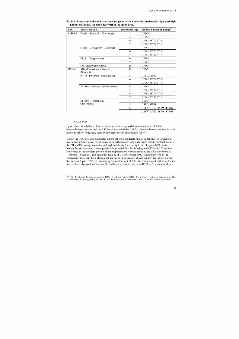
8/12/2019 Mount Baldy
http://slidepdf.com/reader/full/mount-baldy 292/322
Snowy River Resources Ltd.
Table 6: Ecosystem units and structural stages rated as moderate, moderately high, and high
habitat suitability for mule deer within the study area.
BEC Ecosystem Unit Structural Stage Habitat Suitability Rating31
3 2FDG
5 3FDG6 2FDG, 3STG, 3THG
FH (Bl – Horsetail – Glow Moss)
7 2FDG, 3STG, 3THG
3 3FDG
6 3FDG, 3STG, 3THG
FG (Bl – Grouseberry – Cladonia)
7 3FDG, 3STG, 3THG
6 3FDGFT (Bl – Trapper’s tea)
7 3FDG
ESSFdc1
SM (Sedge wet meadow) 2b 3FDG
AB (Alder/Willow – Sedge –Bluejoint)
3b 3FDG
5 3STG, 3THG6 2FDG, 3STG, 3THG
PP (Pl – Pinegrass – kinnikinnick)
7 2FDG, 3STG, 3THG
4 3FDG
5 3FDG, 3STG, 3THG
6 2FDG, 2STG, 2THG
SF (Sxw – Falsebox – Feathermoss)
7 2FDG, 2STG, 2THG
4 3STG
5 3STG, 3THG
6 3STW, 3THG, 1STW, 1THW
MSdm1
ST (Sxw –Trapper’s tea –
Grouseberry)
7 3STW, 3THG, 1STW, 1THW
3.6.2.3 Lynx
Lynx habitat suitability within and adjacent to the proposed development in the ESSFdcu
biogeoclimatic subzone and the ESSFdcp1 variant of the ESSFdc1 biogeoclimatic subzone is rated
as low to nil for forage and security/thermal cover in all seasons (Table 7).
Within the ESSFdc1 biogeoclimatic subzone there is moderate habitat suitability for foraging in
hygric and subhygric soil moisture regimes in the mature, and old growth forest structural stages of
the FH and FR, ecosystem units, and high suitability for security in the old growth FR units.
Young forest successional stage provides high suitability for foraging in the FH units. These units
are located in the northern portion of the proposed development area and are all at elevations of
1,750m to 1,900m asl. The model for lynx in TFL 15 (Geowest 2000) states that “lynx in the
Okanagan valley vary their elevational use based upon season, utilizing higher elevations during
the summer (up to 1,787 m) than during the winter (up to 1,738 m). This seasonal pattern of habitat
use has been observed and was confirmed by other researchers as well”. Based on the model, it is
31 FDG = Feeding in the growing seasons; FDW = Feeding in winter; STG = Security cover in the growing seasons; THG= thermal cover in the growing seasons; STW = Security cover in the winter; THW = Thermal cover in the winter .
18
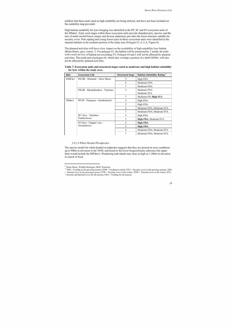
8/12/2019 Mount Baldy
http://slidepdf.com/reader/full/mount-baldy 293/322
Snowy River Resources Ltd.
unlikely that these units rated as high suitability are being utilized, and have not been included on
the suitability map provided.
High habitat suitability for lynx foraging was identified in the PP, SF and ST ecosystem units of
the MSdm1. Early seral stages within these ecosystem units provide abundant prey species, and the
mix of multi-storied forest canopy and diverse understory provides the forest structure suitable forsecurity cover. Pole sapling and young forest types in these ecosystem units were identified in the
riparian habitats in the southern portion of the study area (Polygon #3, 4, 5, 6, Figure 8).
The planned activities will have a low impact on the availability of high suitability lynx habitat
(Brian Harris, pers. comm.32). For polygon #3, the habitat will be transected by 2 nordic ski trails
with a total net loss of habitat not exceeding 5%. Polygon #4 and 5 will not be affected by planned
activities. The north end of polygon #6, which also overlaps a portion of a draft OGMA, will also
not be affected by planned activities.
Table 7: Ecosystem units and structural stages rated as moderate and high habitat suitability
for lynx within the study area.
BEC Ecosystem Unit Structural Stage Habitat Suitability Rating33
5 High FDA
6 Moderate FDA
FH (Bl – Horsetail – Glow Moss)
7 Moderate FDA
5 Moderate FDA
Moderate STA
ESSFdc1
FR (Bl – Rhododendron – Valerian)
7 Moderate FD, High STA
4 High FDA
5 High FDA
6 Moderate FDA, Moderate STA
PP (Pl – Pinegrass – kinnikinnick)
7 Moderate FDA, Moderate STA4 High FDASF ( Sxw – Falsebox –
Feathermoss) 5 High FDA, Moderate STA
4 High FDA
5 High FDA
6 Moderate FDA, Moderate STA
MSdm1
ST (Sxw –Trapper’s tea –
Grouseberry)
7 Moderate FDA, Moderate STA
3.6.2.4 White-Headed Woodpecker
The species model for white-headed woodpecker suggests that they are present in xeric conditions
up to 900m in elevation in the NOH, and breed in the lower biogeoclimatic subzones (the upper
limit would include the IDFdm1). Wandering individuals may stray as high as 1,300m in elevation
in search of food.
32 Brian Harris, Wildlife Biologist, MOE, Penticton.33 FDG = Feeding in the growing seasons; FDW = Feeding in winter; STG = Security cover in the growing seasons; THG= thermal cover in the growing seasons; STW = Security cover in the winter; THW = Thermal cover in the winter; STA= Security and thermal cover for all seasons; FDA = Feeding for all seasons.
19
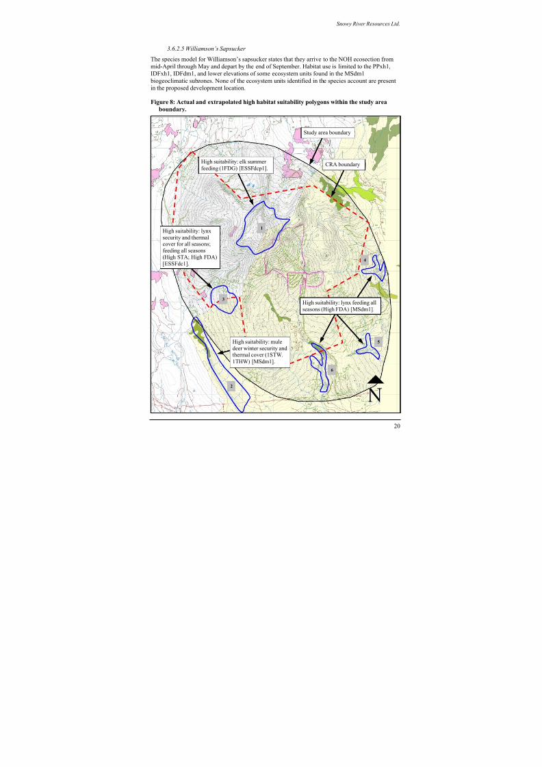
8/12/2019 Mount Baldy
http://slidepdf.com/reader/full/mount-baldy 294/322
Snowy River Resources Ltd.
3.6.2.5 Williamson’s Sapsucker
The species model for Williamson’s sapsucker states that they arrive to the NOH ecosection from
mid-April through May and depart by the end of September. Habitat use is limited to the PPxh1,
IDFxh1, IDFdm1, and lower elevations of some ecosystem units found in the MSdm1
biogeoclimatic subzones. None of the ecosystem units identified in the species account are present
in the proposed development location.
Figure 8: Actual and extrapolated high habitat suitability polygons within the study area
boundary.
CRA boundary
4
3
High suitability: elk summer
feeding (1FDG) [ESSFdcp1].
High suitability: lynx
security and thermalcover for all seasons;
feeding all seasons
(High STA; High FDA)
[ESSFdc1].
High suitability: mule
deer winter security andthermal cover (1STW,
1THW) [MSdm1].
High suitability: lynx feeding all
seasons (High FDA) [MSdm1].
Study area boundary
6
5
1
2
20
8/12/2019 Mount Baldy
http://slidepdf.com/reader/full/mount-baldy 295/322
8/12/2019 Mount Baldy
http://slidepdf.com/reader/full/mount-baldy 296/322
Snowy River Resources Ltd.
8) Garbage pick-up will be carefully scheduled (preferably later in the day) to assure leaving
as little garbage as possible overnight to allow for odor to emanate. If possible, garbage
pick-up will be centralized, meaning that single family residences will be required to drop
garbage in local bear-proof containers.
9) All bear-proof containers will be picked up as quickly as possible to minimize the build upof any odors or spillage.
10) Landscaping and maintenance for the Mt. Baldi Ski Hill will avoid the use of fruit trees,
compost and other bear attractants.
11) Facility personnel will identify and correct operational and maintenance deficiencies
regularly on an on going basis. Inspections will be conducted all year round and comply
with regional standards.
12) All long term commercial operators will be given food and garbage management
guidelines.
13) Any garbage transfer or detainment areas will be fenced with bear-resistant fencing or
electric fencing. These fences will be repaired and maintained as needed within the limits
of available staff and budgets.
14) If garbage is to be burned on-site, all combustible garbage will be burned in enclosed
incinerators. No garbage, including empty cans or other food containers, will be buried;
and,
15) Odor control from sewage facilities will require a demanding management approach.
Sewage lagoons, if any, will be fenced with bear resistant fencing or electric fencing.
These fences will be repaired and maintained as needed.
3.8 Water Quality
3.8.1 McKinney Community Watershed
The upper reaches of McKinney Creek are designated as a Community Watershed39 (Figure 9).
While there are currently no legal water quality objectives that apply to a Community Watershed,
there are specific requirements related to the conduct of forest and range practices that apply to
forest and range tenure holders40 subject to the Forest Practices Code of BC Act or the Forest and
Range Practices Act . With regard to the protection of fish habitat and water quality, these
requirements and best practices are identified in the Operational and Site Planning Regulation, the
Forest Planning and Practices Regulation41 and the Community Watershed Guidebook 42.
The MBSC fully intends on continuing it’s contribution to the maintenance of water quality and
downstream fish habitat by adopting minimum reserve and management zone widths for S2-S4
39 Reference # 320.012. Source: http://srmwww.gov.bc.ca/wat/cws/query/cws.htm 40 The Mt. Baldy Ski Corporation is not a forest or range tenure holder.41 http://www.for.gov.bc.ca/tasb/legsregs/archive/fpc/fpcaregs/oplanreg/opr.htm 42 http://www.for.gov.bc.ca/tasb/legsregs/fpc/FPCGUIDE/WATRSHED/Watertoc.htm.
22
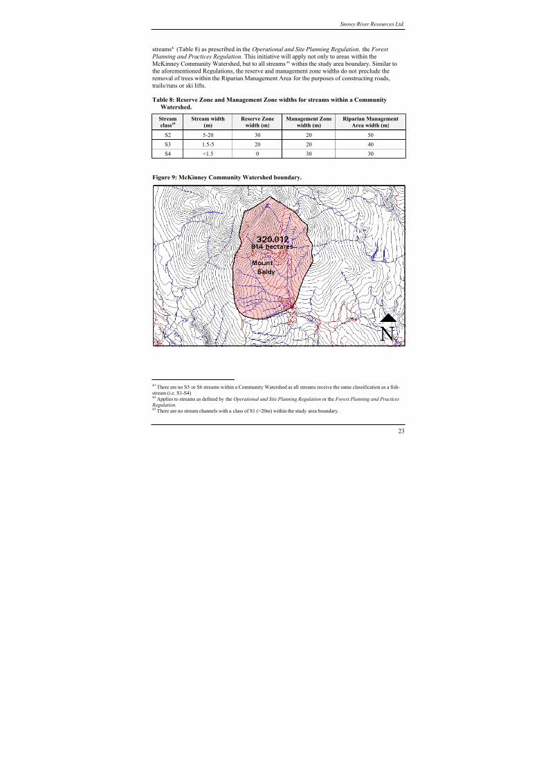
8/12/2019 Mount Baldy
http://slidepdf.com/reader/full/mount-baldy 297/322
Snowy River Resources Ltd.
streams43 (Table 8) as prescribed in the Operational and Site Planning Regulation, the Forest
Planning and Practices Regulation. This initiative will apply not only to areas within the
McKinney Community Watershed, but to all streams44 within the study area boundary. Similar to
the aforementioned Regulations, the reserve and management zone widths do not preclude the
removal of trees within the Riparian Management Area for the purposes of constructing roads,
trails/runs or ski lifts.
Table 8: Reserve Zone and Management Zone widths for streams within a Community
Watershed.
Stream
class45
Stream width
(m)
Reserve Zone
width (m)
Management Zone
width (m)
Riparian Management
Area width (m)
S2 5-20 30 20 50
S3 1.5-5 20 20 40
S4 <1.5 0 30 30
Figure 9: McKinney Community Watershed boundary.
43 There are no S5 or S6 streams within a Community Watershed as all streams receive the same classification as a fish-stream (i.e. S1-S4)44 Applies to streams as defined by the Operational and Site Planning Regulation or the Forest Planning and Practices
Regulation.45 There are no stream channels with a class of S1 (>20m) within the study area boundary.
23
8/12/2019 Mount Baldy
http://slidepdf.com/reader/full/mount-baldy 298/322
Snowy River Resources Ltd.
3.8.2 Erosion and sediment control best management practices
The MBSC accepts that the erosion of surface soils is a primary factor in the degradation of water
quality and fish habitat. To this end, we propose to adopt standard industry best management
practices for erosion and sediment control, focused on minimizing the area of exposed soils, and
seeding soils exposed as part of infrastructure development.
Erosion and sediment control Best Management Practices (BMPs) will be utilized where
appropriate. BMPs are available from a number of sources including the ‘Fish-stream Crossing
Guidebook 46’, ‘Best Management Practices Handbook: Hillslope Restoration in British
Columbia47’, as well as resources available from the International Erosion Control Association
website48.
3.9 Riparian and Fish Habitat
3.9.1 Status of fish distributions within the study area
3.9.1.1 Methods
The location, type and quality of fish habitat is an essential component of applying appropriate
riparian management area strategies as well as providing fish passage at stream crossings.
As part of this assessment, a review of available fish and fish habitat information was undertaken
and supplemented with field assessments where existing information was lacking or incomplete.
The review of existing fish and fish habitat information included: 1) fish presence/absence surveys
completed by the forest licencee (Weyerhaeuser Company Ltd.); 2) data available on the Fish
Inventory Summary System; and 3) surveys completed as part of the environmental assessment for
the Southern Crossing Project (BC Gas). Where data was lacking or incomplete, field assessments
to assess fish and fish habitat were undertaken using methodology described in the Reconnaissance
Fish and Fish Habitat Inventory Manual49 and the Fish-stream Identification Guidebook 50.
3.9.1.2 Results
Figure 10 shows the known distribution of fish within the study area. Fish absence has been
confirmed on all streams within the study area with the exception of two: 1) the upper reaches of
McIntyre Creek; and 2) the upper reaches of Wapiti Creek. For the upper reaches of Wapiti Creek,
however, the stream is shown as an assumed non fish-stream. Based on a previous fisheries
assessment (SSS 2002) the poor quality of fish habitat is likely to be a limiting factor to fish
distribution.
Prior to undertaking this assessment, there was no existing fish inventory information for
McKinney Creek with the exception of a combined electrofishing and minnow trapping survey
conducted by the Westland Resource Group (WRG) as part of the BC Gas Southern Crossing
Project. The survey site was located just upstream of the 15m high falls located by Snowy RiverResources Ltd. Although no fish were captured by WRG, the report does not provide a rationale for
the non fish-bearing status that they recommended.
46 http://www.for.gov.bc.ca/tasb/legsregs/fpc/FPCGUIDE/FishStreamCrossing/FSCGdBk.pdf 47 http://www.for.gov.bc.ca/hfd/pubs/Docs/Mr/Mr096.htm 48 http://www.ieca.org 49 Source: http://srmwww.gov.bc.ca/risc/pubs/aquatic/recon/index.htm 50 Source: http://www.for.gov.bc.ca/tasb/legsregs/fpc/FPCGUIDE/FishStreamCrossing/FSCGdBk.pdf
24
8/12/2019 Mount Baldy
http://slidepdf.com/reader/full/mount-baldy 299/322
Snowy River Resources Ltd.
As part of this project, Snowy River Resources Ltd. undertook a fish inventory of McKinney
Creek. As a result, a 15m high bedrock falls was identified as the upstream limit of fish. Rainbow
trout and eastern brook trout were captured downstream of the falls. However, no fish were
captured upstream of the falls during an electrofishing survey at 3 sites with a total of 600m of
stream sampled (Figures 10 and 11). The 15m high falls, as well as the electrofishing survey
conducted upstream of the falls, provide sufficient rationale to confirm that all watercoursesupstream of the falls are confirmed non fish-streams.
3.9.2 Riparian Management Area Best Management Practices
Section 3.8.1 (this document) describes the minimum Riparian Reserve Zone and Riparian
Management Zone widths that will be applied to all streams within the study area. However, the
MBSC will exceed these minimum requirements, where practicable, adopting best management
practices contained in the OSLRMP51, Riparian Management Area Guidebook 52 and Community
Watershed Guidebook 53 will be applied.
The following riparian retention strategies (Table 9) will be considered for all activities occurring
within the applicable Riparian Management Area. Note that the recommended widths specified
below may be exceeded if warranted to provide additional riparian protection.
Table 9: Riparian Management Area best management practices
Stream class Riparian Management Area Best Management Practices
S2 & S3 • Minimize stream crossing widths on all roads, trails and ski lifts.
• 50% basal area retention in the Management Zone to be averaged over the length of
the S2 stream on the Crown land base. Retain all understory vegetation.
S4 • Minimize crossing widths on all roads, trails and ski lifts.
• Maintain a 10m Reserve Zone. In the Management Zone, target 50% basal area
retention to be averaged over the length of the S4 stream on the Crown land base.
Retain all understory vegetation.
Non classifieddrainages54
• Apply a 5m machine free zone during snow-free periods.
51 The study area lies within the plan area of the OSLRMP and KBLRMP. However, the latter plan does not containspecific best practices for riparian area management. Therefore, the content of the OSLRMP will be consulted for best
practices within the riparian area and applied to the entire study area.52 Source: http://www.for.gov.bc.ca/tasb/legsregs/fpc/fpcguide/riparian/rip-toc.htm 53 Source: http://www.for.gov.bc.ca/tasb/legsregs/fpc/FPCGUIDE/WATRSHED/Watertoc.htm 54 As defined by the Riparian Management Area Guidebook
25
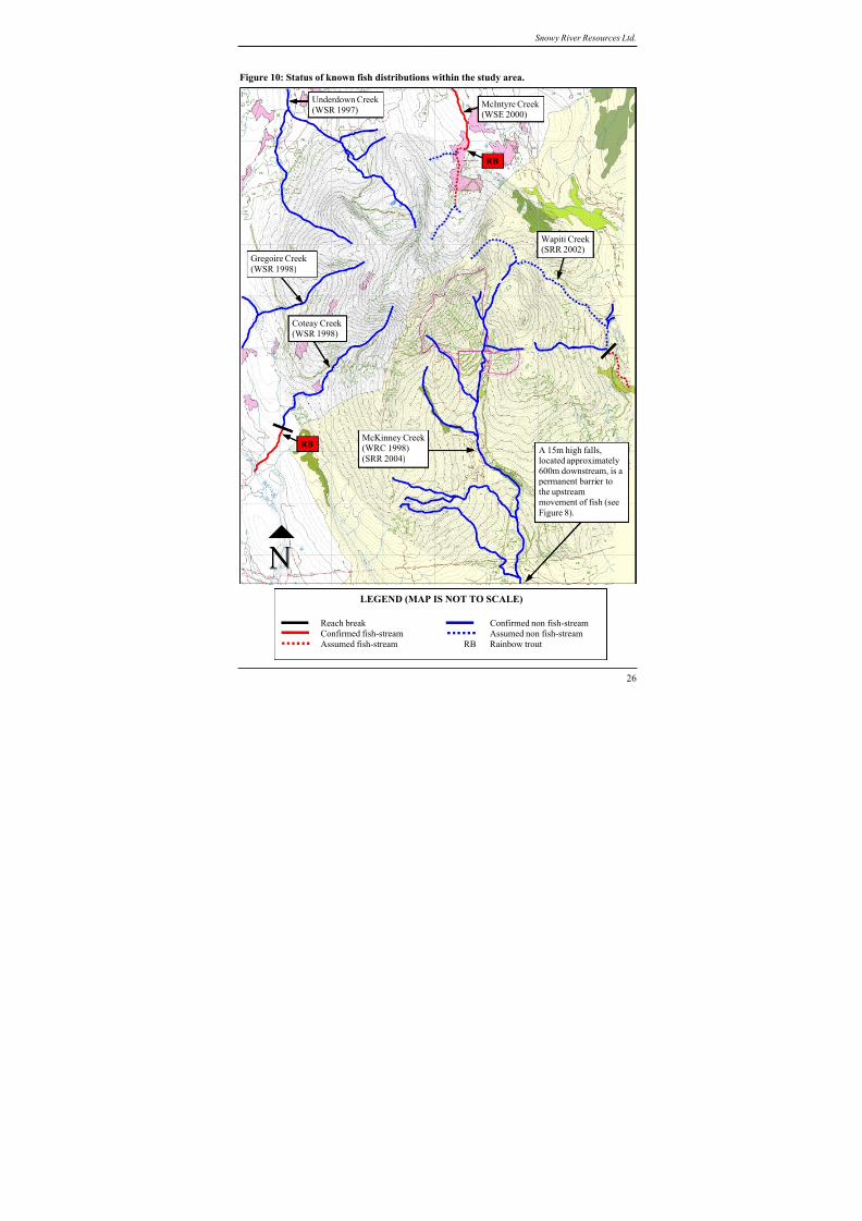
8/12/2019 Mount Baldy
http://slidepdf.com/reader/full/mount-baldy 300/322
Snowy River Resources Ltd.
Figure 10: Status of known fish distributions within the study area.
Figure 8).
RB
Underdown Creek
(WSR 1997)McIntyre Creek (WSE 2000)
Gregoire Creek
(WSR 1998)
Coteay Creek
(WSR 1998)
RBMcKinney Creek
(WRC 1998)
(SRR 2004)A 15m high falls,located approximately
600m downstream, is a permanent barrier to
the upstream
movement of fish (see
Wapiti Creek(SRR 2002)
LEGEND (MAP IS NOT TO SCALE)
Reach break Confirmed non fish-stream
Confirmed fish-stream Assumed non fish-stream
Assumed fish-stream RB Rainbow trout
26
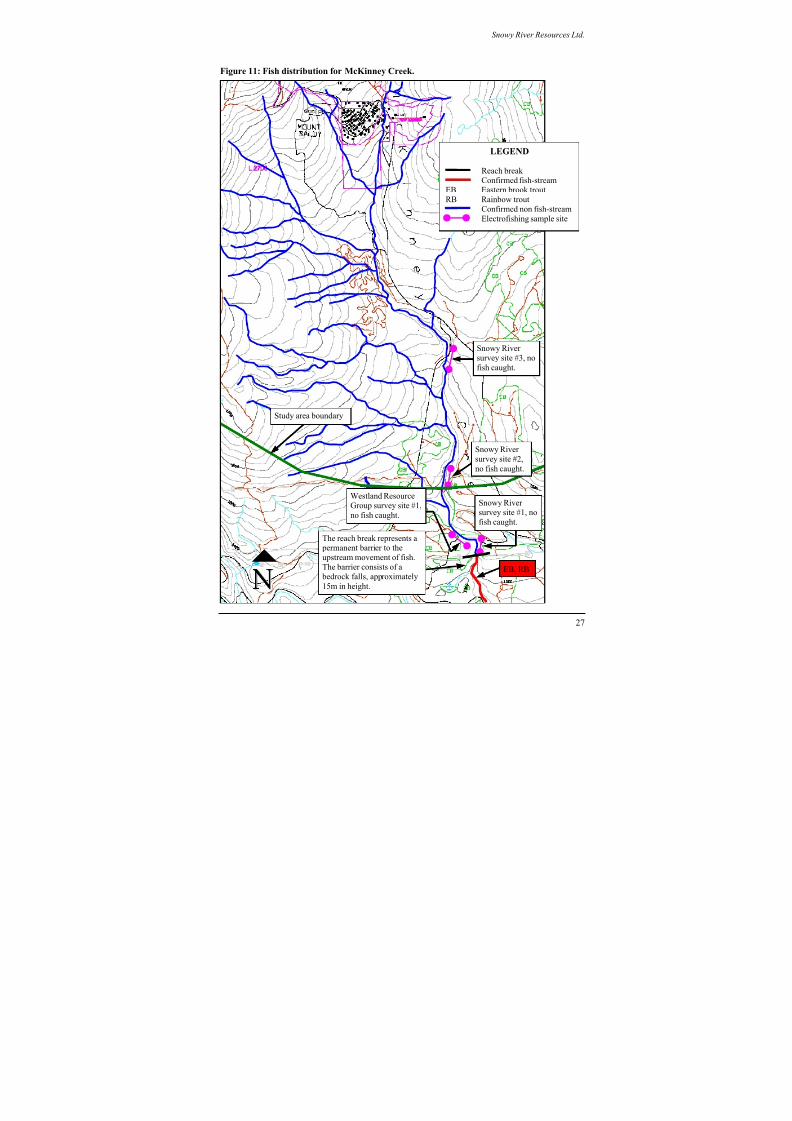
8/12/2019 Mount Baldy
http://slidepdf.com/reader/full/mount-baldy 301/322
Snowy River Resources Ltd.
Figure 11: Fish distribution for McKinney Creek.
27
LEGEND
Reach break
Confirmed fish-streamEB Eastern brook trout
RB Rainbow trout
Confirmed non fish-stream
Electrofishing sample site
Snowy River
survey site #3, no
fish caught.
Study area boundary
Snowy River
survey site #2,
no fish caught.
Westland Resource
Group survey site #1,no fish caught.
Snowy River
survey site #1, no
fish caught.
The reach break represents a
permanent barrier to the
upstream movement of fish.
The barrier consists of a
bedrock falls, approximately
15m in height.
EB, RB
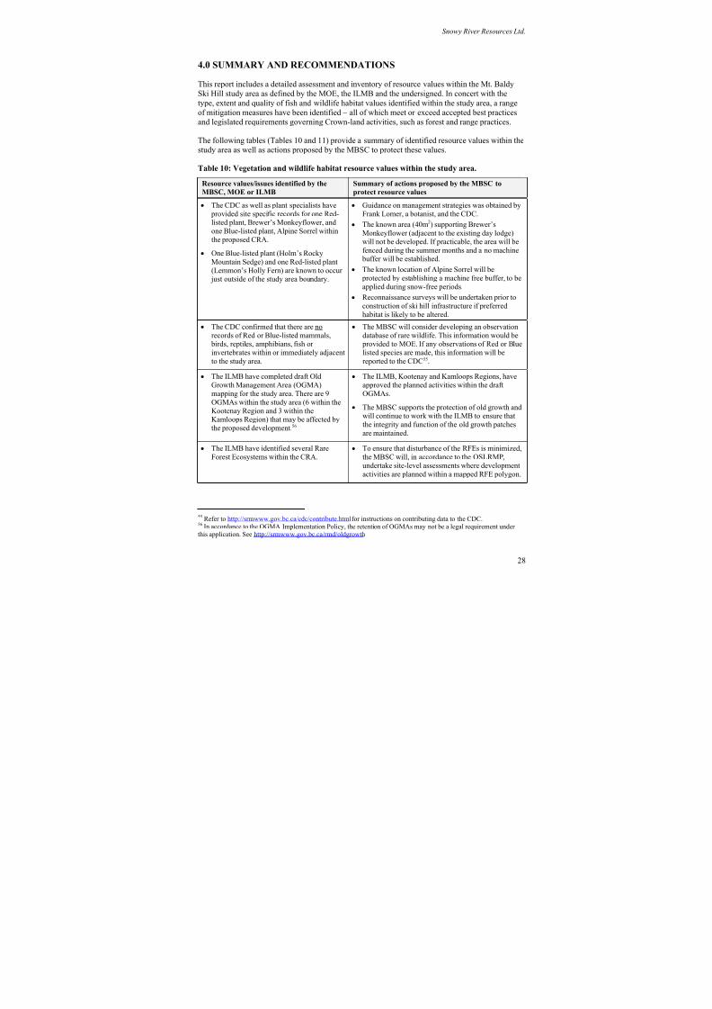
8/12/2019 Mount Baldy
http://slidepdf.com/reader/full/mount-baldy 302/322
Snowy River Resources Ltd.
4.0 SUMMARY AND RECOMMENDATIONS
This report includes a detailed assessment and inventory of resource values within the Mt. Baldy
Ski Hill study area as defined by the MOE, the ILMB and the undersigned. In concert with the
type, extent and quality of fish and wildlife habitat values identified within the study area, a range
of mitigation measures have been identified – all of which meet or exceed accepted best practicesand legislated requirements governing Crown-land activities, such as forest and range practices.
The following tables (Tables 10 and 11) provide a summary of identified resource values within the
study area as well as actions proposed by the MBSC to protect these values.
Table 10: Vegetation and wildlife habitat resource values within the study area.
Resource values/issues identified by the
MBSC, MOE or ILMB
Summary of actions proposed by the MBSC to
protect resource values
• The CDC as well as plant specialists have
provided site specific records for one Red-listed plant, Brewer’s Monkeyflower, and
one Blue-listed plant, Alpine Sorrel withinthe proposed CRA.
• One Blue-listed plant (Holm’s Rocky
Mountain Sedge) and one Red-listed plant
(Lemmon’s Holly Fern) are known to occur just outside of the study area boundary.
• Guidance on management strategies was obtained by
Frank Lomer, a botanist, and the CDC.
•
The known area (40m
2
) supporting Brewer’sMonkeyflower (adjacent to the existing day lodge)
will not be developed. If practicable, the area will be
fenced during the summer months and a no machine buffer will be established.
• The known location of Alpine Sorrel will be
protected by establishing a machine free buffer, to be
applied during snow-free periods.
• Reconnaissance surveys will be undertaken prior to
construction of ski hill infrastructure if preferred
habitat is likely to be altered.
• The CDC confirmed that there are no
records of Red or Blue-listed mammals,
birds, reptiles, amphibians, fish orinvertebrates within or immediately adjacent
to the study area.
• The MBSC will consider developing an observation
database of rare wildlife. This information would be
provided to MOE. If any observations of Red or Bluelisted species are made, this information will be
reported to the CDC55.
• The ILMB have completed draft Old
Growth Management Area (OGMA)
mapping for the study area. There are 9
OGMAs within the study area (6 within the
Kootenay Region and 3 within theKamloops Region) that may be affected by
the proposed development.56
• The ILMB, Kootenay and Kamloops Regions, have
approved the planned activities within the draft
OGMAs.
• The MBSC supports the protection of old growth andwill continue to work with the ILMB to ensure that
the integrity and function of the old growth patches
are maintained.
• The ILMB have identified several Rare
Forest Ecosystems within the CRA.
• To ensure that disturbance of the RFEs is minimized,
the MBSC will, in accordance to the OSLRMP,undertake site-level assessments where development
activities are planned within a mapped RFE polygon.
55 Refer to http://srmwww.gov.bc.ca/cdc/contribute.html for instructions on contributing data to the CDC.56 In accordance to the OGMA Implementation Policy, the retention of OGMAs may not be a legal requirement underthis application. See http://srmwww.gov.bc.ca/rmd/oldgrowth
28
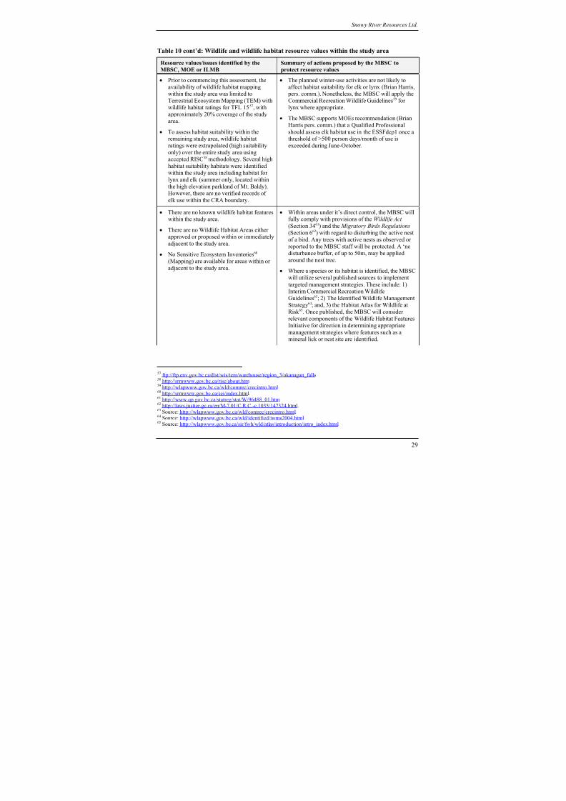
8/12/2019 Mount Baldy
http://slidepdf.com/reader/full/mount-baldy 303/322
Snowy River Resources Ltd.
Table 10 cont’d: Wildlife and wildlife habitat resource values within the study area
Resource values/issues identified by the
MBSC, MOE or ILMB
Summary of actions proposed by the MBSC to
protect resource values
• Prior to commencing this assessment, the
availability of wildlife habitat mappingwithin the study area was limited to
Terrestrial Ecosystem Mapping (TEM) with
wildlife habitat ratings for TFL 1557, withapproximately 20% coverage of the study
area.
• To assess habitat suitability within theremaining study area, wildlife habitat
ratings were extrapolated (high suitability
only) over the entire study area usingaccepted RISC58 methodology. Several high
habitat suitability habitats were identified
within the study area including habitat for
lynx and elk (summer only, located withinthe high elevation parkland of Mt. Baldy).
However, there are no verified records of
elk use within the CRA boundary.
• The planned winter-use activities are not likely to
affect habitat suitability for elk or lynx (Brian Harris, pers. comm.). Nonetheless, the MBSC will apply the
Commercial Recreation Wildlife Guidelines59 for
lynx where appropriate.
• The MBSC supports MOEs recommendation (Brian
Harris pers. comm.) that a Qualified Professional
should assess elk habitat use in the ESSFdcp1 once athreshold of >500 person days/month of use is
exceeded during June-October.
• There are no known wildlife habitat featureswithin the study area.
• There are no Wildlife Habitat Areas eitherapproved or proposed within or immediately
adjacent to the study area.
• No Sensitive Ecosystem Inventories60
(Mapping) are available for areas within or
adjacent to the study area.
• Within areas under it’s direct control, the MBSC willfully comply with provisions of the Wildlife Act
(Section 3461) and the Migratory Birds Regulations
(Section 662) with regard to disturbing the active nest
of a bird. Any trees with active nests as observed orreported to the MBSC staff will be protected. A ‘no
disturbance buffer, of up to 50m, may be applied
around the nest tree.
• Where a species or its habitat is identified, the MBSCwill utilize several published sources to implement
targeted management strategies. These include: 1)Interim Commercial Recreation Wildlife
Guidelines63; 2) The Identified Wildlife Management
Strategy64; and, 3) the Habitat Atlas for Wildlife atRisk 65. Once published, the MBSC will consider
relevant components of the Wildlife Habitat Features
Initiative for direction in determining appropriate
management strategies where features such as amineral lick or nest site are identified.
57 ftp://ftp.env.gov.bc.ca/dist/wis/tem/warehouse/region_3/okanagan_falls 58 http://srmwww.gov.bc.ca/risc/about.htm 59
http://wlapwww.gov.bc.ca/wld/comrec/crecintro.html 60 http://srmwww.gov.bc.ca/sei/index.html.61 http://www.qp.gov.bc.ca/statreg/stat/W/96488_01.htm.62 http://laws.justice.gc.ca/en/M-7.01/C.R.C.-c.1035/147324.html.63 Source: http://wlapwww.gov.bc.ca/wld/comrec/crecintro.html.64 Source: http://wlapwww.gov.bc.ca/wld/identified/iwms2004.html.65 Source: http://wlapwww.gov.bc.ca/sir/fwh/wld/atlas/introduction/intro_index.html
29
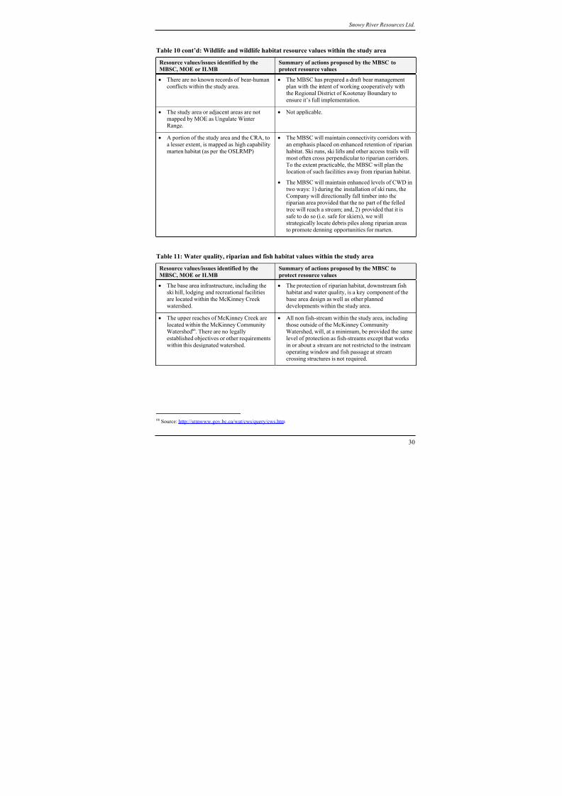
8/12/2019 Mount Baldy
http://slidepdf.com/reader/full/mount-baldy 304/322
Snowy River Resources Ltd.
Table 10 cont’d: Wildlife and wildlife habitat resource values within the study area
Resource values/issues identified by the
MBSC, MOE or ILMB
Summary of actions proposed by the MBSC to
protect resource values
• There are no known records of bear-human
conflicts within the study area.
• The MBSC has prepared a draft bear management
plan with the intent of working cooperatively withthe Regional District of Kootenay Boundary to
ensure it’s full implementation.
• The study area or adjacent areas are not
mapped by MOE as Ungulate WinterRange.
• Not applicable.
• A portion of the study area and the CRA, to
a lesser extent, is mapped as high capability
marten habitat (as per the OSLRMP)
• The MBSC will maintain connectivity corridors with
an emphasis placed on enhanced retention of riparian
habitat. Ski runs, ski lifts and other access trails will
most often cross perpendicular to riparian corridors.To the extent practicable, the MBSC will plan the
location of such facilities away from riparian habitat.
• The MBSC will maintain enhanced levels of CWD in
two ways: 1) during the installation of ski runs, the
Company will directionally fall timber into theriparian area provided that the no part of the felled
tree will reach a stream; and, 2) provided that it is
safe to do so (i.e. safe for skiers), we willstrategically locate debris piles along riparian areas
to promote denning opportunities for marten.
Table 11: Water quality, riparian and fish habitat values within the study area
Resource values/issues identified by theMBSC, MOE or ILMB
Summary of actions proposed by the MBSC toprotect resource values
• The base area infrastructure, including theski hill, lodging and recreational facilities
are located within the McKinney Creek
watershed.
• The protection of riparian habitat, downstream fishhabitat and water quality, is a key component of the
base area design as well as other planned
developments within the study area.
• The upper reaches of McKinney Creek are
located within the McKinney CommunityWatershed66. There are no legally
established objectives or other requirements
within this designated watershed.
• All non fish-stream within the study area, including
those outside of the McKinney CommunityWatershed, will, at a minimum, be provided the same
level of protection as fish-streams except that works
in or about a stream are not restricted to the instream
operating window and fish passage at stream
crossing structures is not required.
66 Source: http://srmwww.gov.bc.ca/wat/cws/query/cws.htm
30
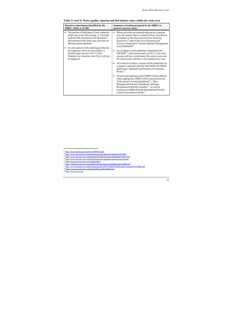
8/12/2019 Mount Baldy
http://slidepdf.com/reader/full/mount-baldy 305/322
Snowy River Resources Ltd.
Table 11 cont’d: Water quality, riparian and fish habitat values within the study area
Resource values/issues identified by the
MBSC, MOE or ILMB
Summary of actions proposed by the MBSC to
protect resource values
• The portion of McKinney Creek within the
study area is non fish bearing. A 15m high bedrock falls, located several kilometers
downstream of the study area, prevents all
fish movement upstream.
• It is the opinion of the undersigned that the
development will in no way result in a
HADD under Section 35(1)67 of theFisheries Act, therefore, the CEAA will not
be triggered.
• Where activities are planned adjacent to a riparian
area, the stream, lake or wetland will be classified inaccordance to the Operational & Site Planning
Regulation 68 and/or the Forest Planning and
Practices Regulation69 and the Riparian ManagementArea Guidebook 70.
• In accordance to the guidelines contained in the
OSLRMP71, where practicable, all S4 (<1.5m wide)streams will have a minimum 10m reserve zone and
all watercourses will have a 5m machine free zone.
• All works in or about a stream will be undertaken in
a manner consistent with the 2004 MWLAP (MOE)
publication ‘Standards and Practices for Instream
Works’72.
• Erosion and sediment control BMPs will be utilizedwhere appropriate. BMPs will be sourced from the
‘Fish-stream Crossing Guidebook 73’, ‘Best
Management Practices Handbook: Hillslope
Restoration in British Columbia74’, as well asresources available from the International Erosion
Control Association website75.
67 http://laws.justice.gc.ca/en/F-14/60370.html 68 http://www.for.gov.bc.ca/tasb/legsregs/fpc/fpcaregs/oplanreg/opr.htm 69
http://www.for.gov.bc.ca/tasb/legsregs/frpa/frparegs/forplanprac/fppr.htm 70 http://www.for.gov.bc.ca/tasb/legsregs/fpc/fpcguide/riparian/rip-toc.htm 71 http://srmwww.gov.bc.ca/sir/lrmp/okan/ 72 http://wlapwww.gov.bc.ca/wld/documents/bmp/iswstdsbpsmarch2004.pdf 73 http://www.for.gov.bc.ca/tasb/legsregs/fpc/FPCGUIDE/FishStreamCrossing/FSCGdBk.pdf 74 http://www.for.gov.bc.ca/hfd/pubs/Docs/Mr/Mr096.htm 75 http://www.ieca.org
31
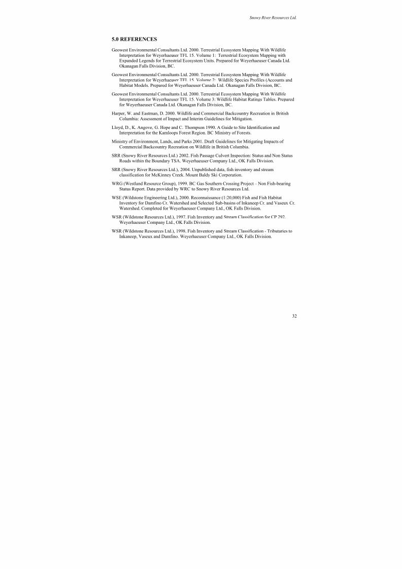
8/12/2019 Mount Baldy
http://slidepdf.com/reader/full/mount-baldy 306/322
Snowy River Resources Ltd.
5.0 REFERENCES
Geowest Environmental Consultants Ltd. 2000. Terrestrial Ecosystem Mapping With Wildlife
Interpretation for Weyerhaeuser TFL 15. Volume 1: Terrestrial Ecosystem Mapping with
Expanded Legends for Terrestrial Ecosystem Units. Prepared for Weyerhaeuser Canada Ltd.
Okanagan Falls Division, BC.
Geowest Environmental Consultants Ltd. 2000. Terrestrial Ecosystem Mapping With Wildlife
Interpretation for Weyerhaeuser TFL 15. Volume 2: Wildlife Species Profiles (Accounts and
Habitat Models. Prepared for Weyerhaeuser Canada Ltd. Okanagan Falls Division, BC.
Geowest Environmental Consultants Ltd. 2000. Terrestrial Ecosystem Mapping With Wildlife
Interpretation for Weyerhaeuser TFL 15. Volume 3: Wildlife Habitat Ratings Tables. Prepared
for Weyerhaeuser Canada Ltd. Okanagan Falls Division, BC.
Harper, W. and Eastman, D. 2000. Wildlife and Commercial Backcountry Recreation in British
Columbia: Assessment of Impact and Interim Guidelines for Mitigation.
Lloyd, D., K. Angove, G. Hope and C. Thompson 1990. A Guide to Site Identification andInterpretation for the Kamloops Forest Region. BC Ministry of Forests.
Ministry of Environment, Lands, and Parks 2001. Draft Guidelines for Mitigating Impacts of
Commercial Backcountry Recreation on Wildlife in British Columbia.
SRR (Snowy River Resources Ltd.) 2002. Fish Passage Culvert Inspection: Status and Non Status
Roads within the Boundary TSA. Weyerhaeuser Company Ltd., OK Falls Division.
SRR (Snowy River Resources Ltd.), 2004. Unpublished data, fish inventory and stream
classification for McKinney Creek. Mount Baldy Ski Corporation.
WRG (Westland Resource Group), 1999. BC Gas Southern Crossing Project – Non Fish-bearing
Status Report. Data provided by WRC to Snowy River Resources Ltd.
WSE (Wildstone Engineering Ltd.), 2000. Reconnaissance (1:20,000) Fish and Fish Habitat
Inventory for Damfino Cr. Watershed and Selected Sub-basins of Inkaneep Cr. and Vaseux Cr.
Watershed. Completed for Weyerhaeuser Company Ltd., OK Falls Division.
WSR (Wildstone Resources Ltd.), 1997. Fish Inventory and Stream Classification for CP 292.
Weyerhaeuser Company Ltd., OK Falls Division.
WSR (Wildstone Resources Ltd.), 1998. Fish Inventory and Stream Classification - Tributaries to
Inkaneep, Vaseux and Damfino. Weyerhaeuser Company Ltd., OK Falls Division.
32
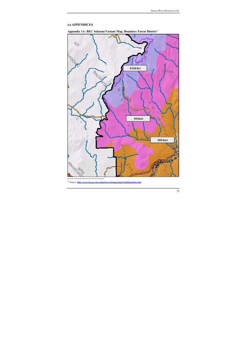
8/12/2019 Mount Baldy
http://slidepdf.com/reader/full/mount-baldy 307/322
Snowy River Resources Ltd.
6.0 APPENDICES
Appendix 1A: BEC Subzone/Variant Map, Boundary Forest District76
IDFdm1
MSdm1
ESSFdc1
33
76 Source: http://www.for.gov.bc.ca/hre/becweb/papermap/FieldMapsIndex.htm

8/12/2019 Mount Baldy
http://slidepdf.com/reader/full/mount-baldy 308/322
Snowy River Resources Ltd.
Appendix 1B: BEC Subzone/Variant Map, Penticton Forest District77
IDFdm1
MSdm1
ESSFdc1
34
77 Source: http://www.for.gov.bc.ca/hre/becweb/papermap/FieldMapsIndex.htm
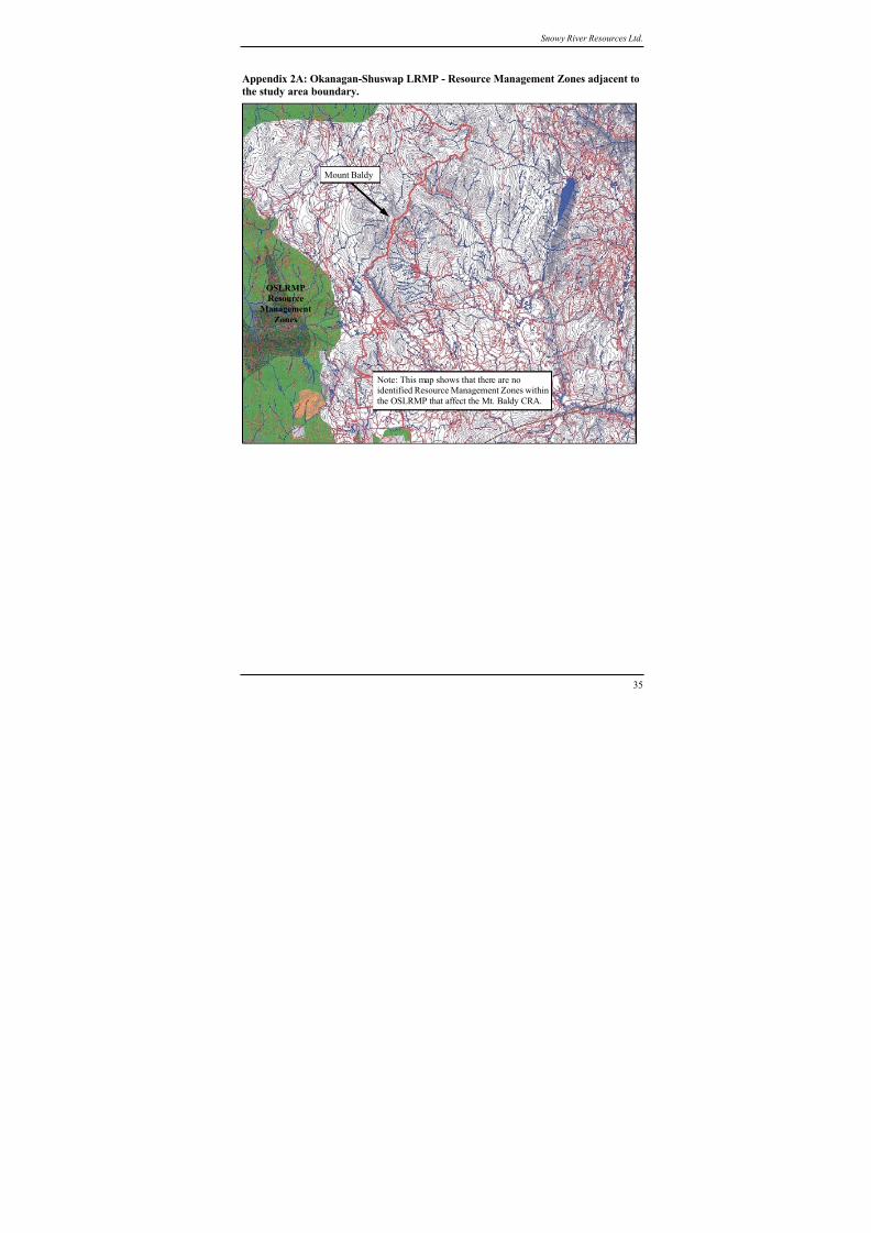
8/12/2019 Mount Baldy
http://slidepdf.com/reader/full/mount-baldy 309/322
Snowy River Resources Ltd.
Appendix 2A: Okanagan-Shuswap LRMP - Resource Management Zones adjacent to
the study area boundary.
Note: This map shows that there are noidentified Resource Management Zones within
the OSLRMP that affect the Mt. Baldy CRA.
Mount Baldy
OSLRMP
Resource
Management
Zones
35
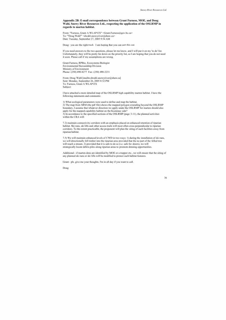
8/12/2019 Mount Baldy
http://slidepdf.com/reader/full/mount-baldy 310/322
Snowy River Resources Ltd.
Appendix 2B: E-mail correspondence between Grant Furness, MOE, and Doug
Wahl, Snowy River Resources Ltd., respecting the application of the OSLRMP in
regards to marten habitat.
From: "Furness, Grant A WLAP:EX" <[email protected]>
To: "'Doug Wahl'" <[email protected]>Date: Tuesday, September 27, 2005 9:54 AM
Doug: you are the right track. I am hoping that you can sort this out.
If you need answers to the two questions, please let me know, and I will put it on my 'to do' list.
Unfortunately, they will be pretty far down on the priority list, so I am hoping that you do not need
it soon. Please call if my assumptions are wrong.
Grant Furness, RPBio, Ecosystems Biologist
Environmental Stewardship Division
Ministry of Environment
Phone: (250) 490-8277 Fax: (250) 490-2231
From: Doug Wahl [mailto:[email protected]]
Sent: Monday, September 26, 2005 8:32 PM
To: Furness, Grant A WLAP:EX
Subject:
I have attached a more detailed map of the OSLRMP high capability marten habitat. I have the
following statements and comments:
1) What ecological parameters were used to define and map the habitat.
2) The map from SRM (the pdf file) shows the mapped polygon extending beyond the OSLRMP
boundary, I assume that whatever direction we apply under the OSLRMP for marten should alsoapply for the mapped capability habitat on the Kootenay side?
3) In accordance to the specified sections of the OSLRMP (page 3-11), the planned activities
within the CRA will:
7.2) maintain connectivity corridors with an emphasis placed on enhanced retention of riparian
habitat. Ski runs, ski lifts and other access trails will most often cross perpendicular to riparian
corridors. To the extent practicable, the proponent will plan the siting of such facilities away from
riparian habitat.
7.5) We will maintain enhanced levels of CWD in two ways: 1) during the installation of ski runs,
we will directionally fell timber into the riparian area provided that the no part of the felled tree
will reach a stream. 2) provided that it is safe to do so (i.e. safe for skiers), we willstrategically locate debris piles along riparian areas to promote denning opportunities.
Additional - if marten dens are identified by MOE or a trapper etc., we will ensure that the siting of
any planned ski runs or ski lifts will be modified to protect such habitat features.
Grant - pls. give me your thoughts. I'm in all day if you want to call.
Doug
36
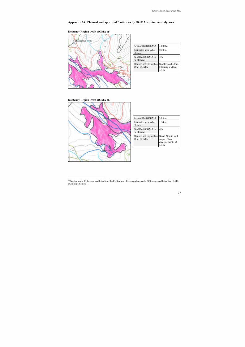
8/12/2019 Mount Baldy
http://slidepdf.com/reader/full/mount-baldy 311/322
Snowy River Resources Ltd.
Appendix 3A: Planned and approved78 activities by OGMA within the study area
Kootenay Region Draft OGMA #5
Area of Draft OGMA 44.03ha.
Estimated area to be
cleared
2.20ha.
% of Draft OGMA to
be cleared5%
Planned activity within
Draft OGMA
Single Nordic trail.
Clearing width of
3-5m.
Area of Draft OGMA 33.5ha.
Estimated area to be
cleared
1.34ha.
% of Draft OGMA to
be cleared
4%
Planned activity within
Draft OGMA
Small Nordic trail
impact. Trail
clearing width of
3-5m.
Kootenay Region Draft OGMA #6
37
78 See Appendix 3B for approval letter from ILMB, Kootenay Region and Appendix 3C for approval letter from ILMB(Kamloops Region).
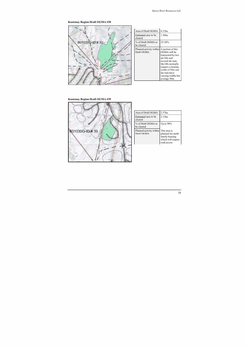
8/12/2019 Mount Baldy
http://slidepdf.com/reader/full/mount-baldy 312/322
Snowy River Resources Ltd.
Kootenay Region Draft OGMA #30
Area of Draft OGMA 6.23ha.
Estimated area to be
cleared
1.56ha.
% of Draft OGMA to
be cleared
25-30%
Planned activity withinDraft OGMA
A portion of thisOGMA will be
transected by two
ski lifts and
several ski runs.
Ski lifts normallyrequire a clearing
width of 50m and
ski runs havevarying widths but
average 50m.
Kootenay Region Draft OGMA #39
Area of Draft OGMA 2.37ha.
Estimated area to becleared 2.13ha.
% of Draft OGMA to
be cleared
Up to 90%
Planned activity within
Draft OGMA
This area is
planned for multi-
family housingwhich will require
road access
38
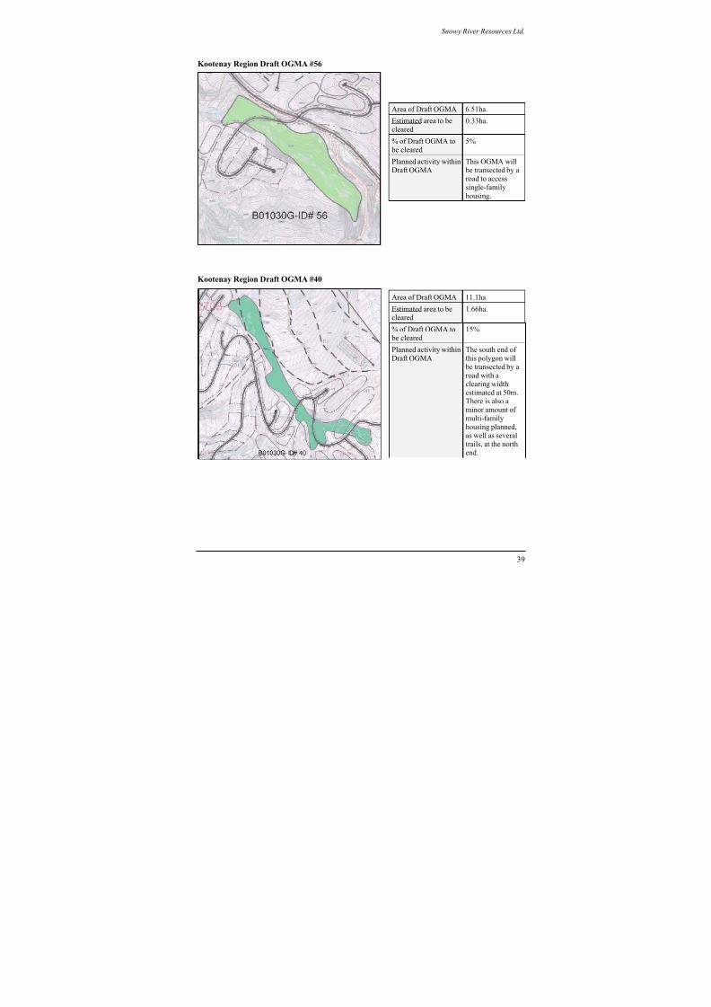
8/12/2019 Mount Baldy
http://slidepdf.com/reader/full/mount-baldy 313/322
Snowy River Resources Ltd.
Kootenay Region Draft OGMA #56
Area of Draft OGMA 6.51ha.
Estimated area to be
cleared0.33ha.
% of Draft OGMA to
be cleared5%
Planned activity within
Draft OGMA
This OGMA will
be transected by aroad to access
single-family
housing.
Kootenay Region Draft OGMA #40
Area of Draft OGMA 11.1ha.
Estimated area to becleared
1.66ha.
% of Draft OGMA to
be cleared
15%
Planned activity within
Draft OGMA
The south end of
this polygon will
be transected by a
road with aclearing width
estimated at 50m.
There is also aminor amount of
multi-family
housing planned,
as well as several
trails, at the north
end.
39
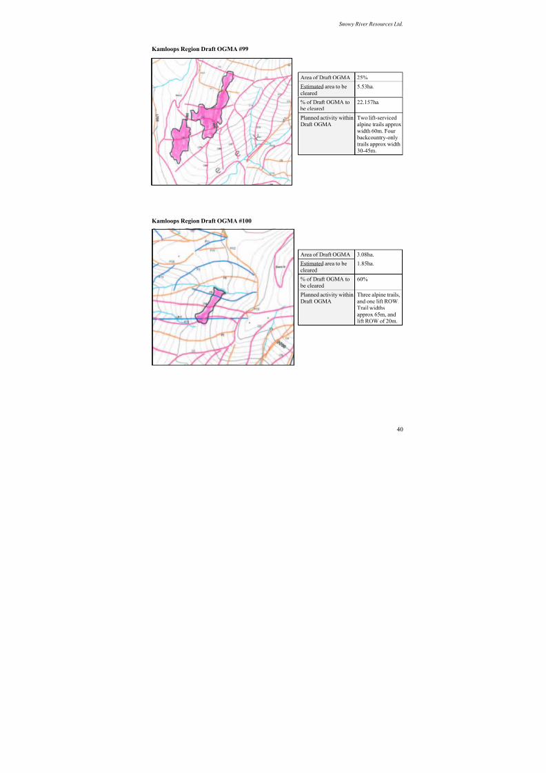
8/12/2019 Mount Baldy
http://slidepdf.com/reader/full/mount-baldy 314/322
Snowy River Resources Ltd.
Kamloops Region Draft OGMA #99
Area of Draft OGMA 25%
Estimated area to becleared
5.53ha.
% of Draft OGMA to
be cleared22.157ha.
Planned activity within
Draft OGMA
Two lift-serviced
alpine trails approx
width 60m. Four backcountry-only
trails approx width
30-45m.
Kamloops Region Draft OGMA #100
Area of Draft OGMA 3.08ha.
Estimated area to becleared
1.85ha.
% of Draft OGMA to
be cleared60%
Planned activity within
Draft OGMA
Three alpine trails,
and one lift ROW.
Trail widthsapprox 65m, and
lift ROW of 20m.
40
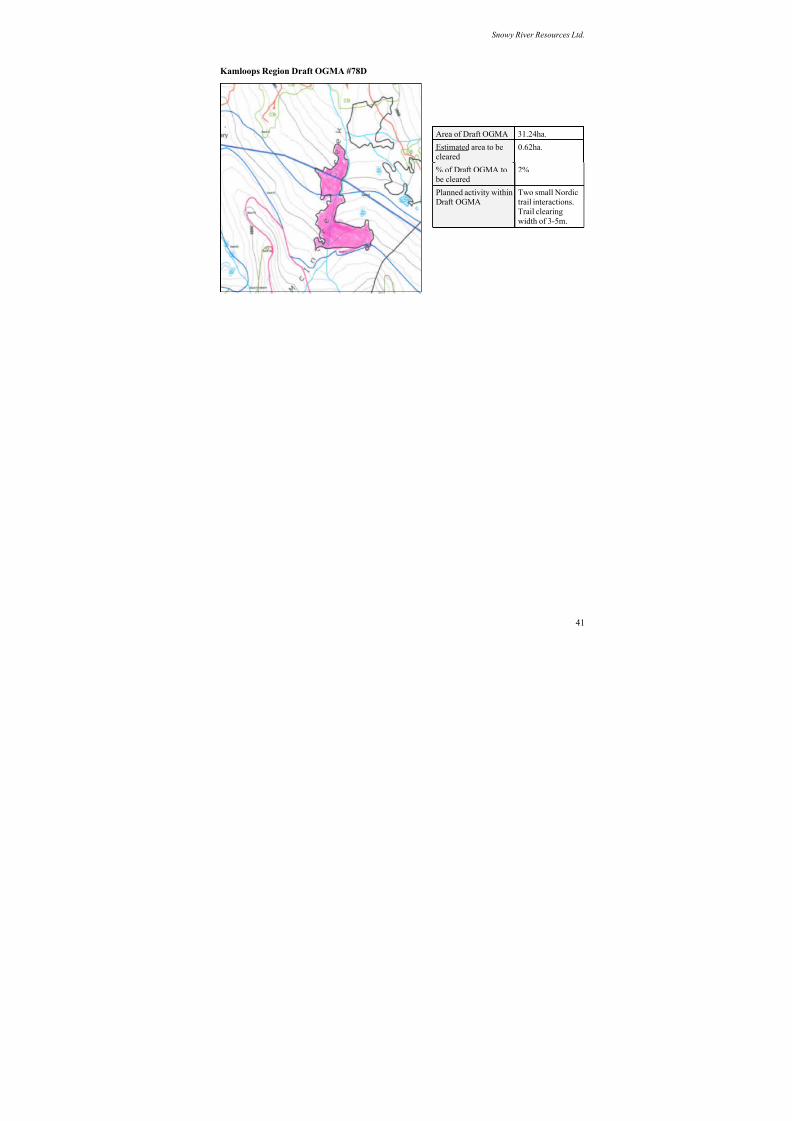
8/12/2019 Mount Baldy
http://slidepdf.com/reader/full/mount-baldy 315/322
Snowy River Resources Ltd.
Kamloops Region Draft OGMA #78D
Area of Draft OGMA 31.24ha.
Estimated area to be
cleared0.62ha.
% of Draft OGMA to
be cleared
2%
Planned activity withinDraft OGMA
Two small Nordictrail interactions.
Trail clearing
width of 3-5m.
41
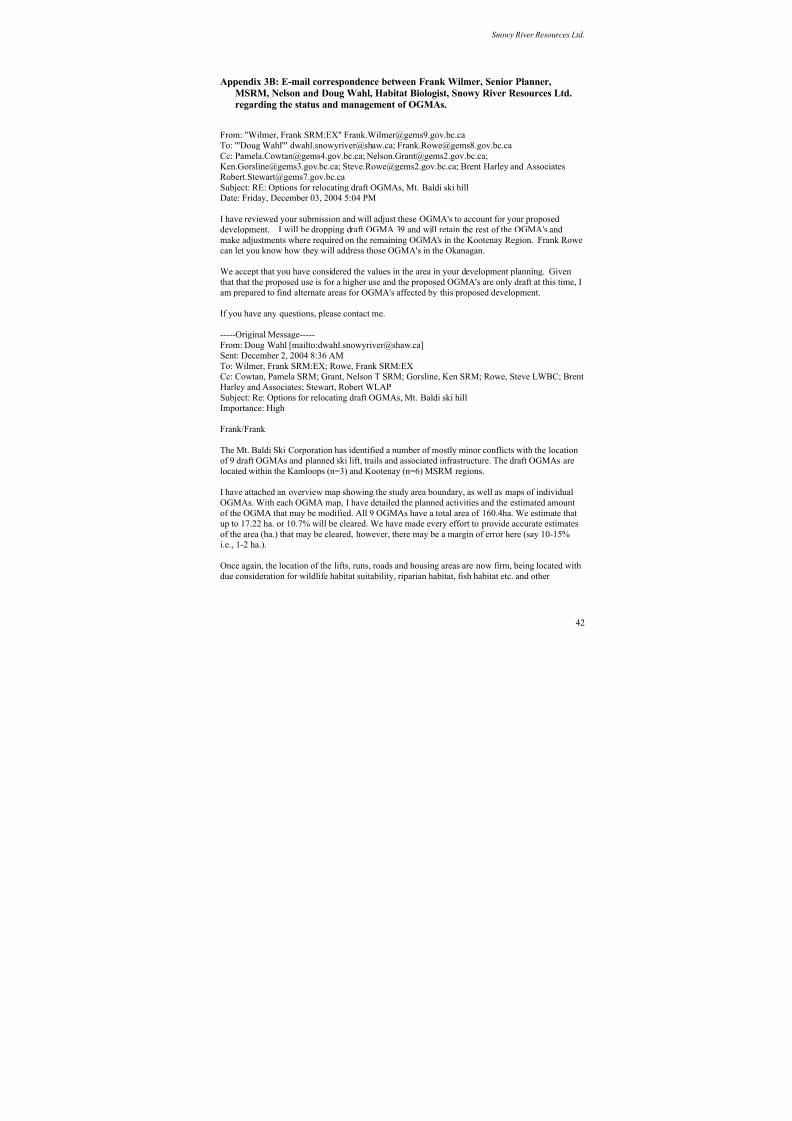
8/12/2019 Mount Baldy
http://slidepdf.com/reader/full/mount-baldy 316/322
Snowy River Resources Ltd.
Appendix 3B: E-mail correspondence between Frank Wilmer, Senior Planner,
MSRM, Nelson and Doug Wahl, Habitat Biologist, Snowy River Resources Ltd.
regarding the status and management of OGMAs.
From: "Wilmer, Frank SRM:EX" [email protected]
To: "'Doug Wahl'" [email protected]; [email protected]
Cc: [email protected]; [email protected];
[email protected]; [email protected]; Brent Harley and Associates
Subject: RE: Options for relocating draft OGMAs, Mt. Baldi ski hillDate: Friday, December 03, 2004 5:04 PM
I have reviewed your submission and will adjust these OGMA's to account for your proposed
development. I will be dropping draft OGMA 39 and will retain the rest of the OGMA's and
make adjustments where required on the remaining OGMA's in the Kootenay Region. Frank Rowe
can let you know how they will address those OGMA's in the Okanagan.
We accept that you have considered the values in the area in your development planning. Given
that that the proposed use is for a higher use and the proposed OGMA's are only draft at this time, I
am prepared to find alternate areas for OGMA's affected by this proposed development.
If you have any questions, please contact me.
-----Original Message-----
From: Doug Wahl [mailto:[email protected]]
Sent: December 2, 2004 8:36 AM
To: Wilmer, Frank SRM:EX; Rowe, Frank SRM:EX
Cc: Cowtan, Pamela SRM; Grant, Nelson T SRM; Gorsline, Ken SRM; Rowe, Steve LWBC; BrentHarley and Associates; Stewart, Robert WLAP
Subject: Re: Options for relocating draft OGMAs, Mt. Baldi ski hill
Importance: High
Frank/Frank
The Mt. Baldi Ski Corporation has identified a number of mostly minor conflicts with the location
of 9 draft OGMAs and planned ski lift, trails and associated infrastructure. The draft OGMAs are
located within the Kamloops (n=3) and Kootenay (n=6) MSRM regions.
I have attached an overview map showing the study area boundary, as well as maps of individual
OGMAs. With each OGMA map, I have detailed the planned activities and the estimated amountof the OGMA that may be modified. All 9 OGMAs have a total area of 160.4ha. We estimate that
up to 17.22 ha. or 10.7% will be cleared. We have made every effort to provide accurate estimates
of the area (ha.) that may be cleared, however, there may be a margin of error here (say 10-15%i.e., 1-2 ha.).
Once again, the location of the lifts, runs, roads and housing areas are now firm, being located with
due consideration for wildlife habitat suitability, riparian habitat, fish habitat etc. and other
42

8/12/2019 Mount Baldy
http://slidepdf.com/reader/full/mount-baldy 317/322
Snowy River Resources Ltd.
identified resource values. At this stage, we have few options other than to re-locate an additional
18ha. of OGMA in areas outside the planned study area.
Please contact me should you require any further clarification regarding our planned activities. I
would appreciate knowing your planned action at your earliest convenience.
Doug Wahl, RPBio, CPESC, Habitat BiologistSnowy River Resources Ltd.
13807 Latimer Ave.
Summerland BC V0H 1Z1Phone/Cell (250) 809-9093; Fax (250) 404-0229
***************************************************
Habitat Protection for Natural Resource,
Urban & Transportation Development
For your reference:
Ski runs: pink, blue, black, orange and green lines
Lifts: straight linesRoads: the heavier weight black linesSolid line polygons (black/white) indicate multi-family areas
Dot-dash-dot polygons: indicate single family areas
----- Original Message -----
From: Doug mailto:[email protected] Wahl
Cc: [email protected]; [email protected];
[email protected]; [email protected]; [email protected];
[email protected] Associates
Sent: Thursday, November 25, 2004 6:28 PM
Subject: Re: Options for relocating draft OGMAs, Mt. Baldi ski hill
Frank
Thank-you for pursuing this matter so quickly. We will prepare a response under Option 2 (for the
two OGMAs within the base area) and submit it to you for review sometime next week.
Sincerely,
Doug Wahl, RPBio, CPESC, Habitat Biologist
Snowy River Resources Ltd.
13807 Latimer Ave.
Summerland BC V0H 1Z1
Phone/Cell (250) 809-9093; Fax (250) 404-0229
***************************************************
Habitat Protection for Natural Resource,
Urban & Transportation Development
----- Original Message -----
From: [email protected]
43
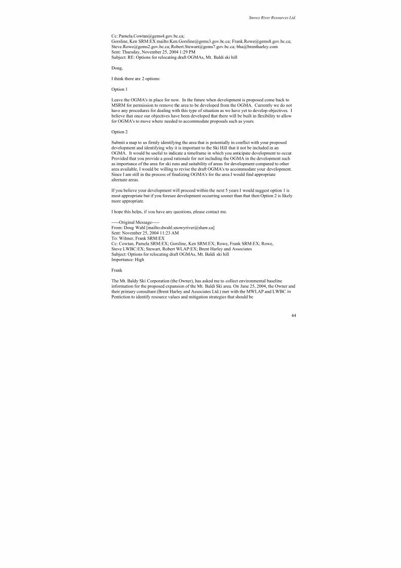
8/12/2019 Mount Baldy
http://slidepdf.com/reader/full/mount-baldy 318/322
Snowy River Resources Ltd.
Cc: [email protected];
Gorsline, Ken SRM:EX mailto:[email protected]; [email protected];
[email protected]; [email protected]; [email protected]
Sent: Thursday, November 25, 2004 1:29 PM
Subject: RE: Options for relocating draft OGMAs, Mt. Baldi ski hill
Doug,
I think there are 2 options:
Option 1
Leave the OGMA's in place for now. In the future when development is proposed come back to
MSRM for permission to remove the area to be developed from the OGMA. Currently we do nothave any procedures for dealing with this type of situation as we have yet to develop objectives. I
believe that once our objectives have been developed that there will be built in flexibility to allow
for OGMA's to move where needed to accommodate proposals such as yours.
Option 2
Submit a map to us firmly identifying the area that is potentially in conflict with your proposed
development and identifying why it is important to the Ski Hill that it not be included in an
OGMA. It would be useful to indicate a timeframe in which you anticipate development to occur.
Provided that you provide a good rationale for not including the OGMA in the development such
as importance of the area for ski runs and suitability of areas for development compared to other
area available, I would be willing to revise the draft OGMA's to accommodate your development.
Since I am still in the process of finalizing OGMA's for the area I would find appropriate
alternate areas.
If you believe your development will proceed within the next 5 years I would suggest option 1 ismost appropriate but if you foresee development occurring sooner than that then Option 2 is likely
more appropriate.
I hope this helps, if you have any questions, please contact me.
-----Original Message-----
From: Doug Wahl [mailto:[email protected]]
Sent: November 25, 2004 11:23 AM
To: Wilmer, Frank SRM:EX
Cc: Cowtan, Pamela SRM:EX; Gorsline, Ken SRM:EX; Rowe, Frank SRM:EX; Rowe,
Steve LWBC:EX; Stewart, Robert WLAP:EX; Brent Harley and Associates
Subject: Options for relocating draft OGMAs, Mt. Baldi ski hill
Importance: High
Frank
The Mt. Baldy Ski Corporation (the Owner), has asked me to collect environmental baselineinformation for the proposed expansion of the Mt. Baldi Ski area. On June 25, 2004, the Owner and
their primary consultant (Brent Harley and Associates Ltd.) met with the MWLAP and LWBC in
Pentiction to identify resource values and mitigation strategies that should be
44
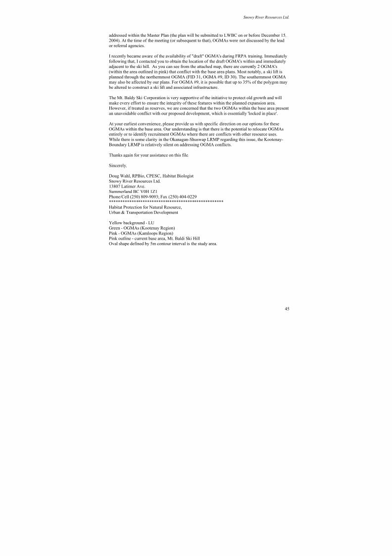
8/12/2019 Mount Baldy
http://slidepdf.com/reader/full/mount-baldy 319/322
Snowy River Resources Ltd.
addressed within the Master Plan (the plan will be submitted to LWBC on or before December 15,
2004). At the time of the meeting (or subsequent to that), OGMAs were not discussed by the lead
or referral agencies.
I recently became aware of the availability of "draft" OGMA's during FRPA training. Immediately
following that, I contacted you to obtain the location of the draft OGMA's within and immediatelyadjacent to the ski hill. As you can see from the attached map, there are currently 2 OGMA's
(within the area outlined in pink) that conflict with the base area plans. Most notably, a ski lift is
planned through the northernmost OGMA (FID 31, OGMA #9, ID 30). The southernmost OGMAmay also be affected by our plans. For OGMA #9, it is possible that up to 35% of the polygon may
be altered to construct a ski lift and associated infrastructure.
The Mt. Baldy Ski Corporation is very supportive of the initiative to protect old growth and will
make every effort to ensure the integrity of these features within the planned expansion area.However, if treated as reserves, we are concerned that the two OGMAs within the base area present
an unavoidable conflict with our proposed development, which is essentially 'locked in place'.
At your earliest convenience, please provide us with specific direction on our options for theseOGMAs within the base area. Our understanding is that there is the potential to relocate OGMAsentirely or to identify recruitment OGMAs where there are conflicts with other resource uses.
While there is some clarity in the Okanagan-Shuswap LRMP regarding this issue, the Kootenay-
Boundary LRMP is relatively silent on addressing OGMA conflicts.
Thanks again for your assistance on this file.
Sincerely,
Doug Wahl, RPBio, CPESC, Habitat Biologist
Snowy River Resources Ltd.
13807 Latimer Ave.Summerland BC V0H 1Z1
Phone/Cell (250) 809-9093; Fax (250) 404-0229
***************************************************
Habitat Protection for Natural Resource,
Urban & Transportation Development
Yellow background - LU
Green - OGMAs (Kootenay Region)
Pink - OGMAs (Kamloops Region)
Pink outline - current base area, Mt. Baldi Ski Hill
Oval shape defined by 5m contour interval is the study area.
45
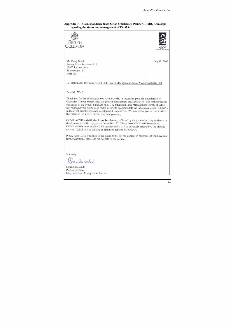
8/12/2019 Mount Baldy
http://slidepdf.com/reader/full/mount-baldy 320/322
Snowy River Resources Ltd.
Appendix 3C: Correspondence from Susan Omelchuck Planner, ILMB, Kamloops
regarding the status and management of OGMAs.
46
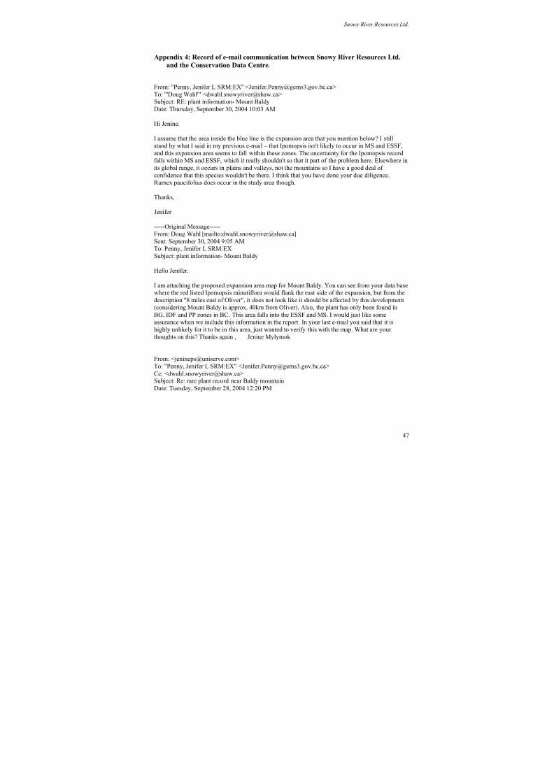
8/12/2019 Mount Baldy
http://slidepdf.com/reader/full/mount-baldy 321/322
Snowy River Resources Ltd.
Appendix 4: Record of e-mail communication between Snowy River Resources Ltd.
and the Conservation Data Centre.
From: "Penny, Jenifer L SRM:EX" <[email protected]>To: "'Doug Wahl'" <[email protected]>
Subject: RE: plant information- Mount Baldy
Date: Thursday, September 30, 2004 10:03 AM
Hi Jenine,
I assume that the area inside the blue line is the expansion area that you mention below? I still
stand by what I said in my previous e-mail – that Ipomopsis isn't likely to occur in MS and ESSF,
and this expansion area seems to fall within these zones. The uncertainty for the Ipomopsis record
falls within MS and ESSF, which it really shouldn't so that it part of the problem here. Elsewhere in
its global range, it occurs in plains and valleys, not the mountains so I have a good deal of
confidence that this species wouldn't be there. I think that you have done your due diligence.Rumex paucifolius does occur in the study area though.
Thanks,
Jenifer
-----Original Message-----
From: Doug Wahl [mailto:[email protected]]
Sent: September 30, 2004 9:05 AM
To: Penny, Jenifer L SRM:EX
Subject: plant information- Mount Baldy
Hello Jenifer.
I am attaching the proposed expansion area map for Mount Baldy. You can see from your data base
where the red listed Ipomopsis minutiflora would flank the east side of the expansion, but from the
description "8 miles east of Oliver", it does not look like it should be affected by this development
(considering Mount Baldy is approx. 40km from Oliver). Also, the plant has only been found in
BG, IDF and PP zones in BC. This area falls into the ESSF and MS. I would just like some
assurance when we include this information in the report. In your last e-mail you said that it is
highly unlikely for it to be in this area, just wanted to verify this with the map. What are your
thoughts on this? Thanks again , Jenine Mylymok
From: <[email protected]>
To: "Penny, Jenifer L SRM:EX" <[email protected]>
Cc: <[email protected]>Subject: Re: rare plant record near Baldy mountain
Date: Tuesday, September 28, 2004 12:20 PM
47
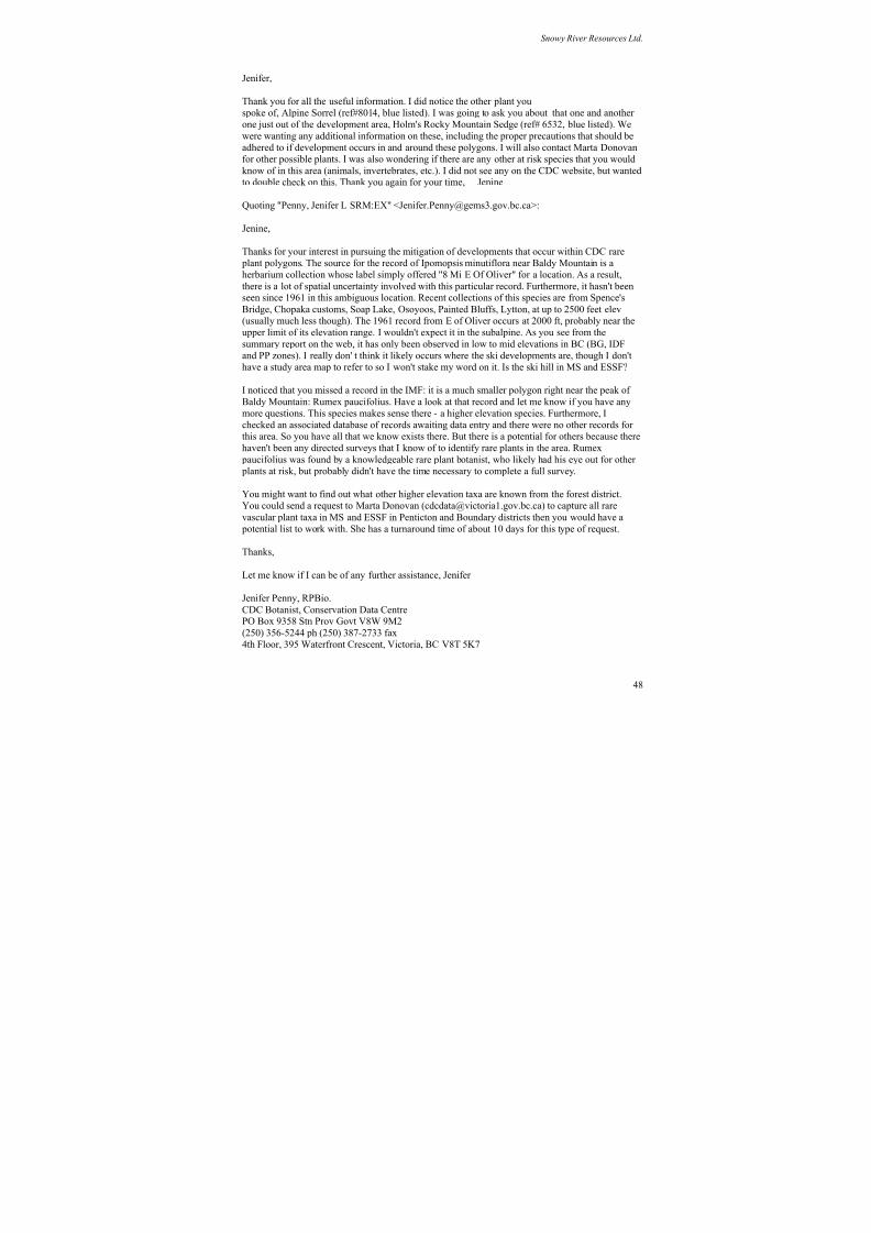
8/12/2019 Mount Baldy
http://slidepdf.com/reader/full/mount-baldy 322/322