planning proposal: 8-10 martin avenue, 9 bidjigal road and 47-49 bonar street, arncliffe
TRANSCRIPT

8-10 Martin Avenue, 9 Bidjigal Road and 47-49 Bonar Street, Arncliffe
Planning Proposal
On behalf of
Canberra Estates Consortium No.42 Pty Ltd
November 2015


Project Director Adam Coburn
Contributor Lauren McMahon
Signed* ………………………… Date:
* This document is for discussion purposes only unless signed and dated by the persons identified. This document has been reviewed by the Project Director.
Contact
Mecone Suite 805, Level 8 185 Elizabeth Street Sydney NSW 2000 www.mecone.com.au [email protected]
© Mecone All Rights Reserved. No part of this document may be reproduced, transmitted, stored in a retrieval system, or translated into any language in any form by any means without the written permission of Mecone. All Rights Reserved. All methods, processes, commercial proposals and other contents described in this document are the confidential intellectual property of Mecone and may not be used or disclosed to any party without the written permission of Mecone.


i
Table of Contents
1 Introduction ............................................................................................................... 3
1.1 Proponent and Project Team ................................................................................ 4
1.2 Background .............................................................................................................. 4
2 The Site ....................................................................................................................... 6
2.1 Site Description and Location ................................................................................ 6
2.2 Local Context .......................................................................................................... 9
2.3 Surrounding development ................................................................................... 10
3 Local Planning Framework .................................................................................... 15
3.1 Rockdale Local Environmental Plan 2011 .......................................................... 15
4 Planning Proposal Overview .................................................................................. 16
5 Part 1 - Objectives and Intended Outcomes ...................................................... 17
5.1 Objectives .............................................................................................................. 17
6 Part 2 – Explanation of Provisions .......................................................................... 18
7 Part 3 – Justification ................................................................................................ 19
7.1 Section A - Need for the proposal ....................................................................... 19
7.2 Section B - Relationship to strategic planning framework ................................ 24
7.3 Section C - Environmental, Social and Economic Impact ............................... 33
7.4 Section D - State and Commonwealth Interests ............................................... 38
8 Part 4 – Mapping ..................................................................................................... 39
9 Part 5 – Community Consultation ......................................................................... 41
10 Part 6 – Project Timeline ......................................................................................... 42
Schedule of Figures and Tables
Figure 1 – The subject site ............................................................................................... 6 Figure 2 – The subject site viewed from Martin Avenue .............................................. 8 Figure 3 – The subject site viewed from Bidjigal Road ................................................ 8 Figure 4 – The subject site viewed from the corner of Bidjigal Road and Martin Avenue ............................................................................................................................. 8 Figure 5 – Legal description image of the subject site ................................................ 9 Figure 6 – View of the nine storey residential flat building at 45 Bonar Street looking north from the subject site .............................................................................. 10 Figure 7 – View of a nine storey residential flat building at 11 Wollongong Street looking south from the subject site .............................................................................. 11 Figure 8 – Photomontage of the two future seven storey residential flat building at 7 Wollongong Road looking northwest from Martin Avenue ................................... 11 Figure 9 – View of three single storey attached dual occupancies located at 51-61 Bonar Street, which are located north of the subject site ................................... 12
ii
Figure 10 – View of three single storey attached dual occupancies located at 51-61 Bonar Street, which are located north of the subject site ................................... 12 Figure 11 – Location of the site in context with surrounding high-density development ................................................................................................................. 13 Figure 12 – Rockdale LEP 2011 land zoning map ....................................................... 19 Figure 13 – Rockdale Height of Buildings map ........................................................... 20 Figure 14 – Rockdale FSR map ..................................................................................... 20 Figure 15 – Bonar Street Structure Plan ........................................................................ 21 Figure 16 – Bonar Street Precinct Public Domain Plan .............................................. 22 Figure 17 – View of the proposed building envelope from Bidjigal Road .............. 34 Figure 18 – An impression of proposed built form of the proposed building envelope from Bidjigal Road ........................................................................................ 35 Figure 19 – Area of setback non-compliance with the Rockdale DCP .................. 36 Figure 20 – Extent of Overshadowing at 9am, Midday and 3pm on 21 June ........ 37 Figure 21 – Existing Building Height map ..................................................................... 39 Figure 22 – Proposed Building Height map ................................................................. 39 Figure 23 – Existing Rockdale FSR map ........................................................................ 40 Figure 24– Proposed FSR map ...................................................................................... 40
Table 1. Project team ..................................................................................................... Table 2. Subject site ....................................................................................................... Table 3. Recent development application in Arncliffe ............................................. Table 4. Rockdale LEP 2011 ........................................................................................... Table 5. Consistency with NSW 2021 ............................................................................ Table 6. Consistency with A Plan for Growing Sydney ............................................... Table 7. Former Draft South Subregional Strategy ...................................................... Table 8. State environmental planning policies ......................................................... Table 9. Section 117 Ministerial Directions ................................................................... Table 10. Built form of surrounding current/future development ............................. Table 11. Project timeline ..............................................................................................
Appendices
Appendix 1 – Concept Design Report ........................................................................ 43 Appendix 2 – VPA letter of offer .................................................................................. 44 Appendix 3 – Traffic Impact Assessment .................................................................... 45 Appendix 4 – LEP Maps for FSR and Building Height ................................................. 46

3
1 Introduction This report has been prepared by Mecone Pty Ltd (Mecone) on behalf of Canberra Estates Consortium No.42 Pty Ltd in support of a Planning Proposal to Rockdale Council (Council) in relation to the site 8-10 Martin Avenue, 9 Bidjigal Road and 47-49 Bonar Street, Arncliffe (referred to herein as “the site”).
The Rockdale Local Environmental Plan 2011 (Rockdale LEP 2011) applies to this land. This Planning Proposal seeks an amendment to the Rockdale LEP 2011 maps to allow consideration of a variation to the height and floor space ratio (FSR) controls for the site. This Planning Proposal has been accompanied by a Voluntary Planning Agreement (VPA), which proposes to deliver additional community infrastructure.
The site is located in Arncliffe and is partly zoned R4 High Density Residential and RE1 Public Recreation. The part of the site zoned R4 High Density Residential is proposed to be redeveloped and will include the following works:
§ Demolition of the existing industrial building;
§ Construction of a 8-9 storey residential flat building and two basement levels for car parking;
§ Construction of a communal open space area; and
§ Site works and landscaping.
The part of the site zoned RE1 Public Recreation is proposed to be redeveloped and dedicated to Council and will include the following works:
§ Demolition of the existing industrial buildings; and
§ Embellishment of the land to create a public park, civic square, site works and landscaping.
The proposal will deliver a number of benefits, including:
§ A residential development that is in a location close to existing transport, community infrastructure, open space and within close proximity to the Westconnex project which creates a socially improved work-home life balance for residents;
§ A high density residential development that incorporates excellent residential amenity and protects the amenity of the residents of future surrounding development;
§ The demolition of the derelict existing industrial building and enable the delivery of the last piece of the Bonar Street Precinct Community Park to the local community;
§ Public domain improvements within the Bonar Street Precinct;
§ A proposal that is consistent with the Plan for Growing Sydney (2014), is located within a Priority Precinct under the Plan for Growing Sydney, and is also consistent with former draft South Sub-regional Strategy;
§ A proposal that is consistent with relevant S.117C directions;
§ The opportunity for future residents to contribute significantly to the local economy;
§ Allow for a proposal that will complement and support the existing and future surrounding land uses and development proposals; and

4
§ A development that contributes to achieving State government housing targets.
The planning proposal contains an explanation of the intended effect and justification of a proposed amendment.
The planning proposal has been prepared in accordance with Section 55 of The Act and the relevant Department of Planning and Environment’s Guides, including ‘A guide to preparing local environmental plans’ (April 2013) and ‘A guide to preparing planning proposals’ (October 2012).
1.1 Proponent and Project Team
The planning proposal has been prepared on behalf of Canberra Estates Consortium No.42 Pty Ltd Table 1 identifies the project team.
Table 1. Project team
Urban Planning Mecone
Architecture/Urban Design Mode Design
Traffic Impact Assessment Transport and Traffic Planning Associates
1.2 Background The site was previously occupied by the company Jetmaster Fireplaces Pty Ltd.
A preliminary development application (DA) was submitted to Rockdale Council for a residential flat building at the site 10 Martin Avenue, Arncliffe. A preliminary DA meeting was held at Council on 23 May 2014. At the meeting Council advised that the council reserve at Bidjigal Road and the area of land at 47-49 Bonar Street zoned R4 High Density Residential would need to be amalgamated with the development site at 8-10 Martin Avenue, to ensure the development proposal would not result in an undesirable isolated site.
Canberra Estates Consortium No.42 Pty Ltd approached Council and advised they would like to sell Council the portion of the land at 47-49 Bonar Street and 9 Bidjigal Road, which was zoned RE1 Public Recreation, which is intended for Bonar Street Precinct and is include a Community Park and through site connection.
Historically the Department of Planning and Environment (The Department) required the land for the future community park to be zoned as open space reservation. The Department suggested to Council to amend its section 94 contributions plan to incorporate the full cost of acquiring the parkland.
Rockdale Section 94 Contributions Plan 2004 identifies the acquisition and embellishment of this Community Park and the embellishment of the Central Square as items for which development contributions will be levied under the plan. It also recognises the possibility of dedication of land by developers in exchange for the transfer of development rights from the area to be dedicated to the remainder of the development site.
Council adopted a strategy to acquire the land for the park by seeking to negotiate Planning Agreements with affected property owners for the dedication of this land, provided any FSR requested could be absorbed within the building height limits set by the Rockdale LEP 2000 and the design principles of SEPP 65 could be met.
5
The developer at the site 45 Bonar Street requested an Instrument change by way of an amendment to the Rockdale LEP 2011 that would allow the site 45 Bonar Street to have a FSR of 3.1:1 for the dedication of the western portion of the Community Park to Council. The Developer offered to enter into a Planning Agreement in accordance with 93F of the Act.
A development application accompanied by a SEPP 1 Objection was later submitted to Council for a residential flat building at the site 45 Bonar Street with an FSR of 3.1:1. The SEPP 1 Objection requested a variation to the 24m height standard to achieve a building height of approximately 31m (nine storeys).
A preliminary design concept for a residential flat building at the site 10 Martin Avenue and 47-49 Bonar Street which achieved an FSR of 3.1:1 and building height of 31m (nine storeys) was submitted to the Rockdale Design Review Panel for comment. Since then there has been further discussions with Council officers, most recently on 11 December 2014, where general design principles were discussed, as a way forward for the design approach for the project. These principles were then contained within email documentation to Village Building Company from Council’s Stephen Kerr, which provided the following:
“The height of the proposed building is not to exceed the finished height of the nearest building at 45 Bonar Street at the western boundary. At the eastern boundary it is not to exceed the height of the tower of the approved development at 63-69 Bonar Street. Any building mass above the height established at the eastern boundary is to be setback from the edges and constructed of a material (preferably lightweight) that differentiates it from the base and reduces the apparent bulk and scale. The higher building element should transition no further than the midpoint of the building, Sunlight to 9-11 Wollongong Road should not be reduced below the minimum standards in the Residential Flat Design Code (RFDC), or if it would be currently less than the RFDC standards as a result of a complying development at 8 and 10 Martin Ave, should not be further reduced.
The basement is to be contained wholly on the development site.
Regard is to be had to the other issues identified by the Design Review Panel.”
The design principles from the latest architectural scheme, which is included in the design report (refer to Appendix 1) was a result of detail discussions with the Rockdale Design Review Panel and the further comments provided by Council officers at the 11 December 2014 meeting and email correspondence.
A draft VPA has been prepared between Rockdale City Council and Canberra Estates Consortium No.42 Pty Ltd (refer to Appendix 2). Canberra Estates Consortium No.42 Pty Ltd has offered to enter into a Planning Agreement in accordance with section 93F of the Act in connection with the Planning Proposal that will deliver the Central Square and Community Park to Council (area of approximately 2,194m2). The Developer is also prepared to make Development Contributions in connection with carrying out of the Development of the land in accordance with this Agreement.
It is noted that 8 Martin Avenue and part of 9 Bidjigal Road are residual parcels of land of the development opposite at 9-11 Wollongong Road. A condition was imposed which required the dedication of these lots to Council and then the transfer of the lots to the owner at 10 Martin Avenue with no FSR entitlement. The original PP submitted and exhibited did not exclude these lots from the FSR calculation however the FSR has now been corrected to exclude these residual sites from the FSR calculation.

6
2 The Site
2.1 Site Description and Location The site is located at 8-10 Martin Avenue, 9 Bidjigal Road and 47-49 Bonar Street. A portion of the site is zoned R4 High Density Residential and is intended to be developed for the purposes of a residential flat building and a portion of the site is zoned RE1 Public Recreation.
Figure 1 below provides an aerial image of the site and its immediate context.
Figure 1 – The subject site Source: Six maps, modified by Mecone
Table 2 provides the legal description and a brief summary of the site.
Table 2. Subject site
Legal description of the developable site
§ 10 Martin Avenue (Lot C, DP158978)
§ 8 Martin Avenue (Lot 2309, DP1159612)
§ A section of 9 Bidjigl Road (Lot 2310, DP1159612)
§ Part of 47 Bonar Street (Lot 1, DP 233666)
§ Part of 49 Bonar Street (Lot 2, DP 233666)
(Refer to Figure 1 for details).
Legal description of the future park
§ A section of 9 BidjigL Road (Lot 2310, DP1159612)
§ Part of 47 Bonar Street (Lot 1, DP 233666)
§ Part of 49 Bonar Street (Lot 2, DP 233666)

7
Table 2. Subject site
(Refer to Figure 1 for details).
Total approximate future park site area
2,198m2
Total approximate future developable site area
3,691m2
Net site area (for FSR calculation)
3,177m2
Note: 8 Martin Avenue and part of 9 Bidjigal Road are residual parcels of land of the development opposite the subject site at 9-11 Wollongong Road (Lot 2309 DP 1159612 and Lot 2310 DP 1159612, respectively).
These lots were unable to be incorporated in the redevelopment of 9-11 Wollongong Road because of the requirement to construct Bidjigal Road. The residual land, however, was included in the calculation of the gross floor area entitlements and the resulting development at 9 - 11 Wollongong Road benefited from these entitlements.
Condition 68 of the approved DA at 9-11 Wollongong Road required the dedication of these lots to Council at no cost. These lots were then to be transferred to the owner of 10 Martin Avenue with no FSR entitlement. A covenant was to be registered on the title of each aforementioned parcel noting that the floor space ratio entitlement has already been exhausted.
Given the above, it is noted that 8 Martin Avenue and part of 9 Bidjigal Road are not incorporated in the FSR calculation.
Road widening
It is noted that under Clause 5.1 and 5.1A of the Rockdale Local Environmental Plan 2011, the 1.6m strip of land along Martin Avenue and 2.7m strip of land along Bonar Street is to be acquired by Rockdale Council for local road widening.
The site description The site is irregular in shape and has a frontage to Bidjigal Road, Martin Avenue and Bonar Street.
The site topography The site is relatively flat and has a cross fall of approximately 1m from the northern rear boundary to the Bidijgal Road frontage.
Existing buildings/ structures
10 Martin Avenue is currently occupied by a single storey warehouse, which stores fireplaces and accessories. 47 Bonar Street contains 1-2 storey warehouse and 49 Bonar Street contains a single storey office and a two storey warehouse.
Vehicular access Vehicular access to 10 Martin Avenue is currently available from Martin Avenue. Vehicle access to 47-49 Bonar Street is available from Bonar Street.
Heritage conservation The site is not a heritage item or does not fall within a heritage conservation area.

8
The below figures provide an image of the site as viewed from the surrounding street network.
Figure 2 – The subject site viewed from Martin Avenue
Figure 3 – The subject site viewed from Bidjigal Road
Figure 4 – The subject site viewed from the corner of Bidjigal Road and Martin Avenue

9
Figure 5 – Legal description image of the subject site Source: Mode design
2.2 Local Context
The site is located in the local government area of Rockdale. The site is located approximately 400m from Arncliffe Station which is located on the Eastern Suburbs and Illawarra Line which provides access to the Sydney CBD and Sydney Airport. The area is also serviced by several bus stops, which complement the rail services.
The M5 Motorway is located to the south of the site and provides access to the Sydney CBD and orbital motorways. The proposed Westconnex would run to the south of the site and will link Sydney’s western suburbs with Sydney Airport and Port Botany.
The suburb of Arncliffe contains a small village shopping centre, which provides a small strip of shops. The Rockdale Town Centre is located to the north of the site (which contains Rockdale Plaza). This centre contains higher order services in comparison to Arncliffe.
Sydney Airport is located 4km to the east of the site. Sydney Airport is a major employment hub and according to the former South Subregional Strategy the Sydney Airport Precinct is expected to grow by around 18,000 jobs toward 2031. The Plan for Growing Sydney recognises the role of the Airport Precinct and the proximity of the employment centre to residential areas such as Arncliffe.
Surrounding development is predominately characterised by modern residential flat buildings seven to nine storeys in height, old single storey industrial buildings and singe storey bungalow houses. The locality is in a process of a transformation from low density residential and industrial uses to high-density residential development.

10
The new development will provide new housing and will assist in meeting the targets set by A Plan for Growing Sydney, and draft sub-regional strategies established by the State Government and the Rockdale Community Strategic Plan 2013-2025
2.3 Surrounding development
The Rockdale LGA is changing with a significant number of developments occurring. In particular, there are a number of major development proposals, which have recently been constructed, approved or being assessed by council. Below is a summary of the major current/future developments, which are within the immediate context of the site. Furthermore, Figure 11 shows the context of the planning proposal in relation to surrounding future built form.
45 Bonar Street
A 31m (nine storey) residential flat building with two basement levels is located at 45 Bonar Street, which is directly north of the subject site (Refer to Figure 6). The development included the dedication of lands for the Bonar Street Precinct Community Park and lands for a new road and road widening purposes. The subdivision to facilitate the road dedication, open space dedication and four Torrens Title lots was also part of the application.
The site is subject to a VPA, which facilitates the dedication of 2,424m2 of the site as a Community Park and the remainder of the site for a high-density residential development with an increased FSR of 3.1:1 to compensate for the land lost for the public open space. The applicant was required under the terms of the VPA to construct the widening of Bonar Street adjacent to the community park.
Figure 6 – View of the nine storey residential flat building at 45 Bonar Street looking north from the subject site
9-11 Wollongong Road
The site at 9-11 Wollongong Road contains two, nine storey residential flat buildings, which contain 182 units, which were recently constructed (Refer to Figure 7).

11
Figure 7 – View of a nine storey residential flat building at 11 Wollongong Street looking south from the subject site
7 Wollongong Road (NEO Apartments)
The site at 7 Wollongong Road contains two separate seven-storey buildings, joined by a communal landscaped garden, containing 82 units, which are currently under construction (Refer to Figure 8).
Figure 8 – Photomontage of the two future seven storey residential flat building at 7 Wollongong Road looking northwest from Martin Avenue Source: Soholane
63-69 Bonar Street
A development application for a seven storey residential flat building with two basement levels was recently determined by Council for the site 63-69 Bonar Street, which is located to the north-east of the site (Refer to Figure 9). The

12
development was approved with a zero lot line to the south-west boundary of the site, three storeys to Bonar Street and four storeys to Martin Avenue.
Figure 9 – View of three single storey attached dual occupancies located at 51-61 Bonar Street, which are located north of the subject site Source: BKA Architects
51-61 Bonar Street
The site 51-53, 55-57 and 59-61 Bonar Street is located south of the subject site and contains three single storey attached dual occupancies. The lots are zoned R4 and subject to a 12-21m height standard. It is envisaged this site will contain a six storey residential flat building in the future (Figure 10).
Figure 10 – View of three single storey attached dual occupancies located at 51-61 Bonar Street, which are located north of the subject site
Figure 11 below provides a description of the surrounding built for context.
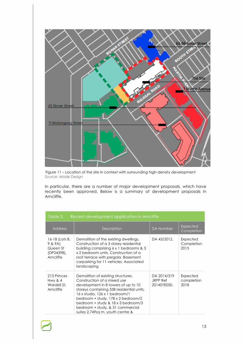
13
Figure 11 – Location of the site in context with surrounding high-density development Source: Mode Design
In particular, there are a number of major development proposals, which have recently been approved. Below is a summary of development proposals in Arncliffe.
Table 3. Recent development application in Arncliffe
Address Description DA Number Expected Completion
16-18 (Lots 8, 9 & 9A) Queen St (DP24398), Arncliffe
Demolition of the existing dwellings. Construction of a 3 storey residential building comprising 6 x 1 bedrooms & 3 x 2 bedroom units. Construction of a roof terrace with pergola. Basement carparking for 11 vehicles. Associated landscaping
DA 43/2012. Expected Completion 2015
213 Princes Hwy & 4 Wardell St, Arncliffe
Demolition of existing structures. Construction of a mixed use development in 8 towers of up to 10 storeys containing 338 residential units, 16 x studio, 126 x 1 bedroom/1 bedroom + study, 178 x 2 bedroom/2 bedroom + study & 18 x 3 bedroom/3 bedroom + study, & 31 commercial suites 2,749sq m, youth centre &
DA 2014/319 JRPP Ref 2014SYE050.
Expected completion 2018

14
Table 3. Recent development application in Arncliffe
Address Description DA Number Expected Completion
associated ball courts. 10 lifts. Construction of a public park. Feature paving, turf areas, play areas & BBQ areas.
63-69 Bonar Street and 27 Booth Street, Arncliffe
Construction of a part three(3) to part six(6) storey residential flat building comprising 51 units and two(2) levels of basement parking and demolition of existing structures
DA 349/2014 Expected Completion 2015
15
3 Local Planning Framework
3.1 Rockdale Local Environmental Plan 2011
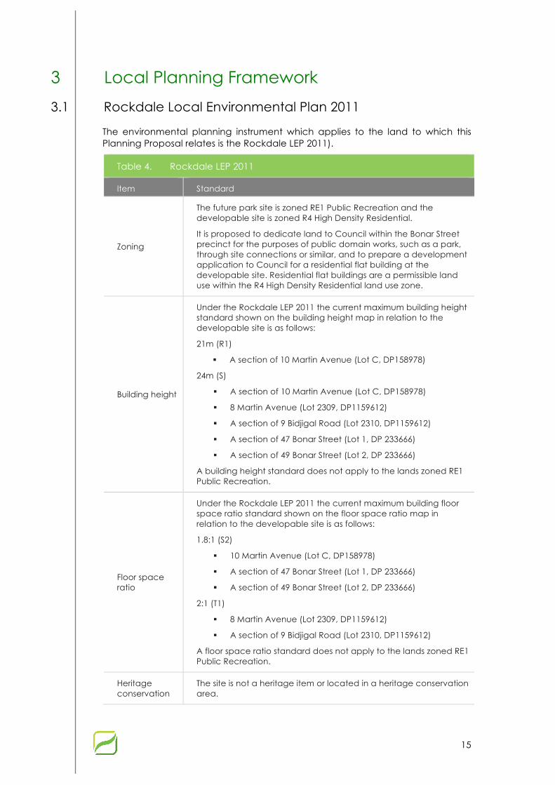
The environmental planning instrument which applies to the land to which this Planning Proposal relates is the Rockdale LEP 2011).
Table 4. Rockdale LEP 2011
Item Standard
Zoning
The future park site is zoned RE1 Public Recreation and the developable site is zoned R4 High Density Residential.
It is proposed to dedicate land to Council within the Bonar Street precinct for the purposes of public domain works, such as a park, through site connections or similar, and to prepare a development application to Council for a residential flat building at the developable site. Residential flat buildings are a permissible land use within the R4 High Density Residential land use zone.
Building height
Under the Rockdale LEP 2011 the current maximum building height standard shown on the building height map in relation to the developable site is as follows:
21m (R1)
§ A section of 10 Martin Avenue (Lot C, DP158978)
24m (S)
§ A section of 10 Martin Avenue (Lot C, DP158978)
§ 8 Martin Avenue (Lot 2309, DP1159612)
§ A section of 9 Bidjigal Road (Lot 2310, DP1159612)
§ A section of 47 Bonar Street (Lot 1, DP 233666)
§ A section of 49 Bonar Street (Lot 2, DP 233666)
A building height standard does not apply to the lands zoned RE1 Public Recreation.
Floor space ratio
Under the Rockdale LEP 2011 the current maximum building floor space ratio standard shown on the floor space ratio map in relation to the developable site is as follows:
1.8:1 (S2)
§ 10 Martin Avenue (Lot C, DP158978)
§ A section of 47 Bonar Street (Lot 1, DP 233666)
§ A section of 49 Bonar Street (Lot 2, DP 233666)
2:1 (T1)
§ 8 Martin Avenue (Lot 2309, DP1159612)
§ A section of 9 Bidjigal Road (Lot 2310, DP1159612)
A floor space ratio standard does not apply to the lands zoned RE1 Public Recreation.
Heritage conservation
The site is not a heritage item or located in a heritage conservation area.

16
4 Planning Proposal Overview Section 55(2) of the Environmental Planning and Assessment Act 1979 outlines the required contents of a planning proposal. The Department of Planning and Environment has produced “A guide to preparing planning proposals” (October 2012) which breaks these requirements into six parts. These parts are addressed in the next chapters as follows:
§ Chapter 5 addresses Part 1 – a statement of the objectives and intended outcomes;
§ Chapter 6 addresses Part 2 – an explanation of the provisions to be included in the proposed instrument;
§ Chapter 7 addresses Part 3 – justification of the objectives, outcomes and the process for implementation;
§ Chapter 8 addresses Part 4 – maps to identify the modifications required to the proposed instrument and the area to which it applies;
§ Chapter 9 addresses Part 5 – details of the community consultation to be undertaken; and
§ Chapter 10 addresses Part 6 – draft timeline for the planning proposal.

17
5 Part 1 - Objectives and Intended Outcomes
5.1 Objectives The objectives of the proposal are:
1. To facilitate redevelopment of the site in a prime location in close proximity to a range of current and future services and public transport options;
2. To provide a high quality residential development;
3. To facilitate a built form which would relate to the form, proportion, composition, scale and character of surrounding buildings, urban grain and public realm;
4. To facilitate redevelopment of the site that takes advantage of the site’s characteristics and minimise any impact on surrounding developments;
5. To facilitate redevelopment that reinforces the street and relationship with the other surrounding development within the precinct, while being sympathetic to the streetscape of Martin Avenue and Bidjigal Road;
6. To assist in achieving state and local government’s housing targets; and
7. Increase residential population who will significantly contribute to the local economy.

18
6 Part 2 – Explanation of Provisions This Planning Proposal seeks an amendment to the Rockdale LEP 2011 to allow for the consideration of a variation to the height and FSR controls for the site. The development would be subject to compliance and satisfaction of the design quality principles in SEPP 65, through the development application process.
Specifically the planning proposal seeks to achieve the intended outcomes outlined above and in Part 1 of this report through amending the FSR and Building Height maps of the Rockdale LEP 2011 (refer to Appendix 4).
The intention of the amended LEP maps is to allow Council to consider a development application that proposes a height and FSR, which is greater than the current planning controls. This will facilitate the development of a building that considers the surrounding built form, height and density. This will deliver a building that is more responsive to the surrounding context.
To facilitate an outcome that is beneficial to the proponent and deliver better amenity to local residents, an upper height and FSR limit will be applied – these are detailed below. This will give the developer and community certainty in the development potential for the site.
• Height Limit: 31m
• FSR limit: 3.93:1
Note: it is reiterated that 8 Martin Avenue and part of 9 Bidjigal Road are excluded from the site area which is used to calculate the proposed FSR for the site, refer to Table 2 ‘Net site area’ for further detail.
The PP originally proposed an FSR of 3.4:1 however there was an error in the calculation of the FSR as it included 8 Martin Avenue and part of 9 Bidjigal Road in the site area. From the previous exhibition period, the FSR calculation has been revised using the ‘net site area’ which excludes 8 Martin Avenue and part of 9 Bidjigal Road given these sites have been exhausted as part of the development at 9-11 Wollongong Road. The actual site area of 3,691m2 will remain the same, however the site area for the purposes of calculating the FSR is 3,177m2.
There is a subsequent development application (DA 2015/421) in Council at the moment which is to be assessed concurrently with the subject PP. The revised FSR will not increase the proposed building envelope in the DA or the previously exhibited PP while it is emphasised that the changes to the FSR only relate to the amended site area for the purposes of calculating the FSR. Furthermore, there are no changes to the proposed built form as shown in the Design Report which was included as part of the PP endorsed by Council on 4th February 2015. The design of the building for the DA has been subject to extensive consultation with Council’s Planners and its Design Review Panel over a course of the last 18 months.

19
7 Part 3 – Justification
7.1 Section A - Need for the proposal
1. Is the planning proposal a result of any strategic study or report?
Increase in the building height and FSR development standard
The Rockdale LEP 2011, Rockdale DCP 2011, Bonar Street Precinct Public Domain Plan and Rockdale Section 94 Contribution Plan have identified that part of the site 47-49 Bonar Street and 9 Bidijgal Road is to be used as a public park in the future. The remainder of the site is zoned for high density residential uses.
In order to achieve a reasonable development outcome and allow for planned public open space to be delivered, consideration of a greater building height and FSR on the land zoned for higher density development is considered to be reasonable.
Rockdale LEP 2011
Rockdale LEP 2011 land use zoning map indicates that the future park is zoned RE1 Pubic Recreation and the developable site is zoned R4 High Density Residential.
Figure 6 – Rockdale LEP 2011 land zoning map Source: Rockdale Council, modified by Mecone
Height of Building (HOB)
The existing HOB map contained within Rockdale LEP 2011 is provided below.

20
Subject site
Figure 7 – Rockdale Height of Buildings map Source: Rockdale LEP 2011
Under the Rockdale LEP 2011 the current maximum HOB shown on the HOB map in relation to the developable site is as follows:
• The developable site is subject to a maximum HOB of part 21m (A section of 10 Martin Avenue) and part 24m (8 Martin Avenue, a section of 10 Martin Avenue, a section of 9 Bidjigal Road and a section of 47-49 Bonar Street on the HOB Map (Sheet HOB_003).
• A HOB standard does not apply to the lands zoned RE1 Public Recreation where the future park site will be located.
Floor Space ratio (FSR)
The FSR map, as contained within Rockdale LEP 2011 is reproduced below.
Subject site
Figure 8 – Rockdale FSR map Source: Rockdale LEP 2011

21
Under the Rockdale LEP 2011 the current maximum FSR standard shown on the FSR map in relation to the developable site is as follows:
• The developable site is subject to a maximum FSR of part 2:1 (8 Martin Avenue and section of 9 Bidjigal Road) and part 1.8:1 (10 Martin Avenue and a section of 47-49 Bonar Street on the FSR Map (Sheet FSR_003).
• An FSR standard does not apply to the lands zoned RE1 Public Recreation where the future park site will be located.
Rockdale DCP 2011
The Rockdale DCP 2011 Structure Plan indicates that part of the site 47-49 Bonar Street and 9 Bidjigal Road is to be used as a community park and central square.
Figure 9 – Bonar Street Structure Plan Source: Rockdale Council, modified by Mecone
Rockdale Bonar Street Precinct Public Domain Plan
The Bonar Street Precinct Public Domain Plan indicates part of the site 47-49 Bonar Street and 9 Bidjigal Road is to be used as a local/town park and civic space consistent with its RE1 Public open space zoning. The Bonar Street Precinct Community Park is to Service the new residential precinct around Bonar Street and function as a gathering point, informal sports area, picnic facilities and local playground.

22
Figure 10 – Bonar Street Precinct Public Domain Plan Source: Rockdale Council
Rockdale Section 94 Contributions Plan
Rockdale Section 94 Contributions Plan 2004 identifies the acquisition and embellishment of this Community Park and the embellishment of the Central Square as items for which development contributions will be levied under the plan. It also recognises the possibility of dedication of land by developers in exchange for the transfer of development rights from the area to be dedicated to the remainder of the development site.
Council adopted a strategy to acquire the land for the park by seeking to negotiate Planning Agreements with affected property owners for the dedication of this land, provided any FSR requested could be absorbed within the building height limits set by the Rockdale LEP 2000 and the design principles of SEPP 65 could be met.
The above environmental planning instrument, development control plan and public domain plan clearly indicate the need for the provisions of the future public open space.

23
2. Is the planning proposal the best means of achieving the objectives and outcomes, or is there a better way?
Canberra Estates Consortium No.42 Pty Ltd approached Council and advised they would like to sell the portion of the land at 47-49 Bonar Street and 9 Bidjigal Roadv to Council, which is zoned RE1 Public Recreation and to be used for public domain improvements in the form of a community park and through site connection.
Historically the Department required the land for the community park to be zoned as open space reservation. The Department suggested that Council amend its section 94 contributions plan to incorporate the full cost of acquiring the parkland.
Rockdale Section 94 Contributions Plan 2004 identifies the acquisition and embellishment of this Community Park and the embellishment of the Central Square as items for which development contributions will be levied under the plan. It also recognises the possibility of dedication of land by developers in exchange for the transfer of development rights from the area to be dedicated to the remainder of the development site.
Council adopted a strategy to acquire the land for the park by seeking to negotiate Planning Agreements with affected property owners for the dedication of this land. To achieve a viable development outcome on the remainder of the site higher FSR was considered, provided the design principles of SEPP 65 could be met and that the overall scheme and planning agreement demonstrated public benefit.
The developer at the site 45 Bonar Street requested an Instrument change by way of an amendment to the Rockdale LEP 2011 that would allow the site 45 Bonar Street to have a FSR of 3.1:1 for the dedication of the western portion of the Community Park to Council. The Developer offered to enter into a Planning Agreement in accordance with 93F of the Act.
An alternative to submitting a planning proposal with council would be submitting a development application, which would be accompanied by a Clause 4.6 Variation written request for the departure with the FSR and height development standard.
Council advised that they were concerned with the extent of the variation to the FSR and height controls as contained in Rockdale LEP 2011 for the subject site at Martin Avenue. This is on the basis that the proposed departure to the FSR and height controls contained within RLEP are substantial. Council recommended that a planning proposal be submitted that would facilitate an acceptable viable development outcome and enable the delivery of the planned open space.
Accordingly, the planning proposal is the best means of achieving the desired objectives and outcomes as a straight sale of the open space to Council would not be in the interest of the public or Council. Further, that a Clause 4.6 Variation in isolation would be inappropriate for the site given the significant departure from the FSR and building height standard.
24
7.2 Section B - Relationship to strategic planning framework
3. Is the planning proposal consistent with the objectives and actions contained within the applicable regional or sub-regional strategy (including the Metropolitan Strategy and exhibited draft strategies)?
NSW State Plan
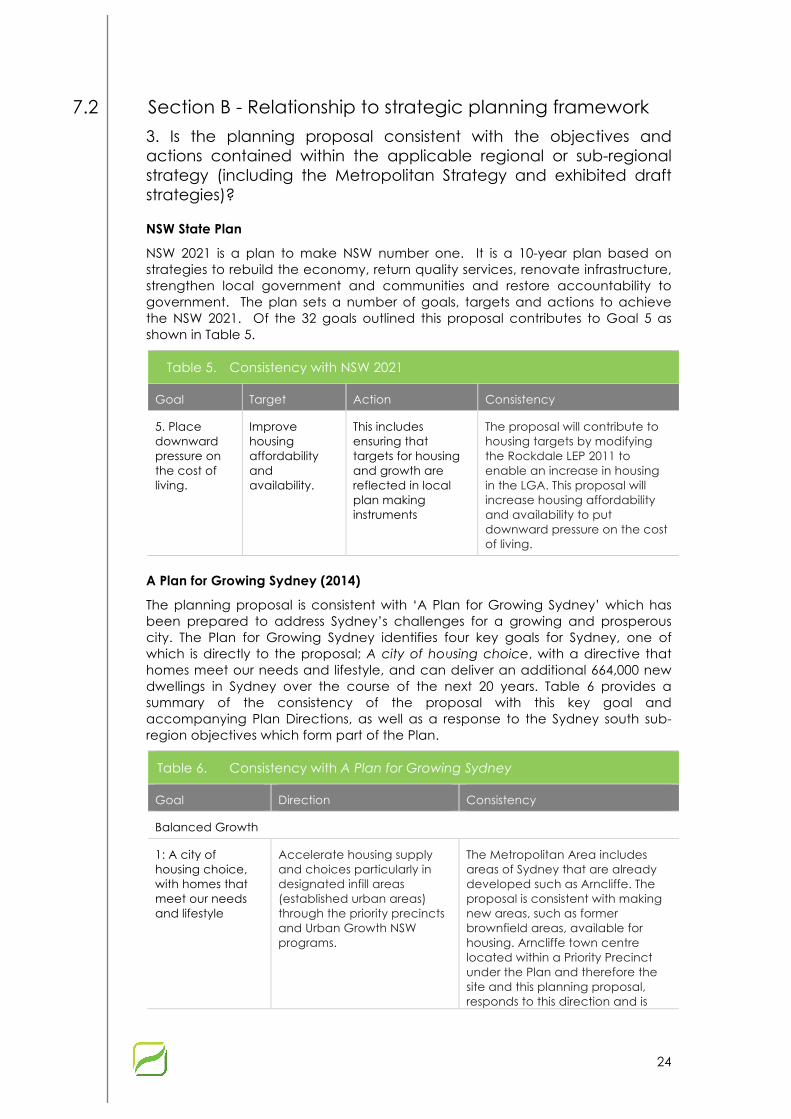
NSW 2021 is a plan to make NSW number one. It is a 10-year plan based on strategies to rebuild the economy, return quality services, renovate infrastructure, strengthen local government and communities and restore accountability to government. The plan sets a number of goals, targets and actions to achieve the NSW 2021. Of the 32 goals outlined this proposal contributes to Goal 5 as shown in Table 5.
Table 5. Consistency with NSW 2021
Goal Target Action Consistency
5. Place downward pressure on the cost of living.
Improve housing affordability and availability.
This includes ensuring that targets for housing and growth are reflected in local plan making instruments
The proposal will contribute to housing targets by modifying the Rockdale LEP 2011 to enable an increase in housing in the LGA. This proposal will increase housing affordability and availability to put downward pressure on the cost of living.
A Plan for Growing Sydney (2014)
The planning proposal is consistent with ‘A Plan for Growing Sydney’ which has been prepared to address Sydney’s challenges for a growing and prosperous city. The Plan for Growing Sydney identifies four key goals for Sydney, one of which is directly to the proposal; A city of housing choice, with a directive that homes meet our needs and lifestyle, and can deliver an additional 664,000 new dwellings in Sydney over the course of the next 20 years. Table 6 provides a summary of the consistency of the proposal with this key goal and accompanying Plan Directions, as well as a response to the Sydney south sub-region objectives which form part of the Plan.
Table 6. Consistency with A Plan for Growing Sydney
Goal Direction Consistency
Balanced Growth
1: A city of housing choice, with homes that meet our needs and lifestyle
Accelerate housing supply and choices particularly in designated infill areas (established urban areas) through the priority precincts and Urban Growth NSW programs.
The Metropolitan Area includes areas of Sydney that are already developed such as Arncliffe. The proposal is consistent with making new areas, such as former brownfield areas, available for housing. Arncliffe town centre located within a Priority Precinct under the Plan and therefore the site and this planning proposal, responds to this direction and is
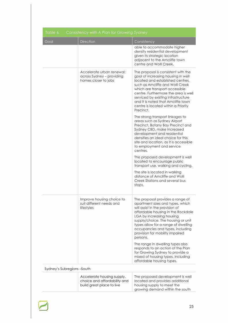
25
Table 6. Consistency with A Plan for Growing Sydney
Goal Direction Consistency
able to accommodate higher density residential development given its strategic location adjacent to the Arncliffe town centre and Wolli Creek.
Accelerate urban renewal; across Sydney – providing homes closer to jobs
The proposal is consistent with the goal of increasing housing in well located and established centres, such as Arncliffe and Wolli Creek which are transport accessible centre. Furthermore the area is well serviced by existing infrastructure and it is noted that Arncliffe town centre is located within a Priority Precinct.
The strong transport linkages to areas such as Sydney Airport Precinct, Botany Bay Precinct and Sydney CBD, make increased development and residential densities an ideal choice for this site and location, as it is accessible to employment and service centres.
The proposed development is well located to encourage public transport use, walking and cycling.
The site is located in walking distance of Arncliffe and Wolli Creek Stations and several bus stops.
Improve housing choice to suit different needs and lifestyles
The proposal provides a range of apartment sizes and types, which will assist in the provision of affordable housing in the Rockdale LGA by increasing housing supply/choice. The housing or unit types allow for a range of dwelling occupancies and types, including provision for mobility impaired persons.
The range in dwelling types also responds to an action of the Plan for Growing Sydney to provide a mixed of housing types, including affordable housing types.
Sydney’s Subregions –South
Accelerate housing supply, choice and affordability and build great place to live
The proposed development is well located and provides additional housing supply to meet the growing demand within the south

26
Table 6. Consistency with A Plan for Growing Sydney
Goal Direction Consistency
sub-region of Sydney. The intensification of development is supported on this site, due largely to Arncliffe town centre being recognised within the Priority Precinct program.
Furthermore the site is located within the designated urban renewal corridor within figure 23 of the Plan for Growing Sydney.
The proposed development is considered appropriate in contributing to more intense housing in a transport accessible area. In particular, the proposal will provide increased housing supply in close proximity to a significant State Government transport investment, being WestConnex.
Draft South Sub-regional Strategy
Table 7. Former Draft South Subregional Strategy
Objective Policy Consistency
Housing
C1. Ensure adequate supply of land and sites for residential development
C.1.3 Plan for increased housing capacity targets in existing areas
The planning proposal is consistent with providing for increased housing in an existing area. It will also contribute to achieving the housing target of 35,000 new dwellings in the South Sub-region by 2031. It will also assist in achieving the Rockdale LGA target of 7,000 dwellings.
C2. Plan for a housing mix near jobs, transport and services
C2.1 Focus residential development around centres, town centres, villages and neighbourhoods
The planning proposal is consistent with providing housing in close proximity to Arncliffe Village Centre and Rockdale Town Centre.
C2.3 Provide a mix of housing The proposal provides a range of apartment sizes and will increase the affordability of housing in the Rockdale LGA by significantly increasing housing supply.
C4. Improving housing affordability
C.4.1 Improve the affordability of housing
The proposal provides a range of apartment sizes and will increase the affordability of housing in the Rockdale LGA by significantly increasing housing supply.

27
4. Is the planning proposal consistent with a council’s local strategy or other local strategic plan?
Rockdale Community Strategic Plan 2013-2025
The Rockdale City Plan (City Plan) is the Rockdale City Council’s long term community plan that identifies the objectives of the community and establishes a framework with how the Council will work with the community and key stakeholders to deliver the City Plan’s objectives. The City Plan is a 10 year vision and is aligned with the Council’s long term resourcing and workforce management plan and its capital works delivery program – therefore being an integrated plan for the future.
The City Plan identifies that the LGA will accommodate an additional 5,900 dwellings in the next 10-15 years, with most of the housing being in medium and high density developments.
The City Plan recognises the Urban Activation Precinct (now ‘Priority Precincts’) and identifies Arncliffe town centre as a Priority Precinct which is within close proximity to the site. Council’s desire to encourage redevelopment in these parts of the City is reflected in their urban planning framework. Importantly the Priority Precincts provides an opportunity for the Council to partner with Government to deliver community infrastructure within and adjoining the precinct. The planning proposal is consistent with the City Plan in this regard and seeks to provide public domain, which forms part of a broader urban renewal corridor.
Outcome 2 of the City Plan identifies a number of objectives, which relevantly include for this Planning Proposal the following:
“Our City has a well managed and sustainable built environment, quality and diverse development with effective housing choice. “
The planning proposal seeks to facilitate a contemporary high density residential development, that will be well designed, consistent with SEPP 65 and provides a range of unit sizes and types to suit a diverse community.
The overall proposal is consistent with the City Plan and would facilitate the delivery of greater housing choice, whilst completing a valuable public open space area (Town Square) within the locality, which provides public domain improvements in the form of a through site link and recreation area.
Princess Highway Corridor Strategy (2013)
The Princess Highway Corridor Strategy sets the strategic direction for the Princess Highway Corridor between Rockdale and Wolli Creek (the ‘Study Area’). The Strategy addresses to key areas, these are: centre growth and renewal as well as corridor revitalization. It should be noted that the Site falls just outside the Study Area, however, this Strategy still has relevance in regard to the desired future character of Arncliffe.
Of particular relevance to this Proposal is the strategic vision for Arncliffe. The objectives include:
§ Grow and strengthen Arncliffe as a predominantly residential precinct;
§ Facilitate growth through a relatively high density residential urban form;
§ Reinforce the intersection of Burrows Road and the Princes Highway as a key activity node;

28
§ Improve pedestrian access to and across Arncliffe Station;
§ Maintain the western side of the rail station as the primary retail / neighbourhood shops precinct; and
§ Improve the amenity and connectivity of the precinct through new open space, new street and pedestrian connections and public domain improvements.
Whilst the site is not within the strategy’s study area, the proposal is in line with the above objectives, as it will include high-density residential development urban form in the vicinity of Arncliffe Station. Furthermore, increasing the residential population in Arncliffe will strengthen its role as a village.
5. Is the planning proposal consistent with the applicable state environmental planning policies?
The proposal would address and/or be consistent with all relevant Environmental Planning Policies (SEPPs). The following outlines the intent of the relevant SEPPs and consistency of the planning proposal.
Table 8. State environmental planning policies
SEPP Consistent Comments
SEPP No. 1- Development Standards
Consistent Not applicable. It does not apply to Rockdale LEP 2011.
SEPP No. 14 – Coastal Wetlands
Not Applicable
SEPP No. 15 – Rural Landsharing Communities
Not Applicable
SEPP No. 19 – Bushland in Urban Areas
Not Applicable
SEPP No 21 – Caravan Parks Not Applicable
SEPP No. 26 – Littoral Rainforests
Not Applicable
SEPP No. 29 – Western Sydney Recreation Area
Not Applicable
SEPP No. 30 – Intensive Agriculture
Not Applicable
SEPP No. 32 – Urban Consolidation (Redevelopment of Urban Land)
Consistent The proposal is an example of urban renewal. The proposal meets the aims and objectives of this SEPP.
SEPP No. 33 – Hazardous and Offensive Development
Consistent
The proposal is to adopt the standard instrument definitions of hazardous and offensive development, which are not permitted on site.
SEPP No. 36 – Manufactured Home Estates
Not Applicable

29
Table 8. State environmental planning policies
SEPP Consistent Comments
SEPP No. 39 – Spit Island Bird Habitat
Not Applicable
SEPP No. 44 – Koala Habitat Protection
Not Applicable
SEPP no. 50 – Canal Estate Development
Not Applicable
SEPP No. 52 – Farm Dams and Other Works in Land and Water Management Plan Areas
Not Applicable
SEPP No. 55 – Remediation of Land
Not Applicable The site would be appropriately remediated to make it suitable for residential development.
SEPP No. 59 – Central Western Sydney Regional Open Space and Residential
Not Applicable
SEPP No. 62 – Sustainable Aquaculture
Not Applicable
SEPP No. 64 – Advertising and Signage
Consistent Any future proposals for signage and advertising structures would be consistent with the SEPP.
SEPP NO. 65 – Design Quality of Residential Flat Development
Consistent The proposal has been designed by leading architects Mode Design and is generally consistent with the provisions of SEPP 65. Refer to the design report at Appendix 1 for further information.
SEPP No. 70 – Affordable Housing (Revised Schemes)
Consistent The proposal would not affect the schemes within this SEPP, nor does it propose any new scheme for affordable housing that would need to be included in this SEPP.
SEPP No. 71 – Coastal Protection
Not Applicable
SEPP (Affordable Rental Housing) 2009
Consistent This proposal does not inhibit any operations of this SEPP.
SEPP (Building Sustainability Index: BASIX) 2004
Consistent This proposal does not inhibit any operations of this SEPP.
SEPP (Exempt and Complying Development Codes 2008
Consistent The proposal is to adopt the standard instrument provisions for exempt and complying development.

30
Table 8. State environmental planning policies
SEPP Consistent Comments
SEPP (Infrastructure) 2007 Consistent The proposed development will be referred to the RMS when the DA is lodged.
SEPP (Kosciuszko National Park – Alpine Resorts) 2007
Not Applicable
SEPP (Kurnell Peninsula) 1989 Not Applicable
SEPP (Major Development) 2005
Consistent The proposal does not inhibit operations of the former Part 3A provisions or the replacement measures.
SEPP (Rural Lands) 2008 Not Applicable
SEPP (State and Regional Development) 2011
Not Applicable
SEPP (Sydney Drinking Water Catchment) 2011
Not Applicable
SEPP (Sydney Region Growth Centres) 2006
Not Applicable
SEPP (Urban Renewal) 2010 Not Applicable
SEPP (Western Sydney Employment Area) 2009
Not Applicable
SREP No. 8 – Central Coast Plateau Areas
Not Applicable
SREP No. 9 – Extractive Industry (No 2 – 1995)
Not Applicable
SREP No. 16 – Walsh Bay Not Applicable
SREP No. 18 – Public Transport Corridors
Not Applicable
SREPP No. 19 – Rouse Hill Development Area
Not Applicable
SREP No. 20 – Hawkesbury – Nepean River (No 2 – 1997)
Not Applicable
SREP No. 24 – Homebush Bay Area
Not Applicable
SREP No. 25 – Orchard Hills Not Applicable
SREP No. 26 – City West Not Applicable
SREP No. 30 – St Marys Not Applicable
31
Table 8. State environmental planning policies
SEPP Consistent Comments
SREP No. 33 – Cooks Cove Not Applicable
SREP (Sydney Harbour Catchment) 2005
Not Applicable
6. Is the planning proposal consistent with applicable Ministerial Directions (S. 117 directions)?
The planning proposal is consistent with all relevant S117 Directions. The assessment of these is outlined in Table 9 below.
Table 9. Section 117 Ministerial Directions
Clause Direction Consistent Comments
1 Employment and Resources
1.1 Business and Industrial Zones
Consistent
The planning proposal does not seek to change the land use zoning and therefore does not seek to reduce the extent of business zones in the locality.
2 Environment and Heritage
2.3 Heritage Conservation Not Applicable
The Rockdale LEP 2011 contains heritage provisions. This planning proposal does not seek to amend these.
3 Housing, Infrastructure and Urban Development
3.1 Residential Zones Consistent
The proposal allows for a range of residential unit types, which are consistent with the existing trends and market demands.
3.2 Caravan Parks and Manufactured Home Estates
Not Applicable
3.3 Home Occupations Not Applicable
3.4 Integrating Land Use and Transport
Consistent
The site is within walking distance to a range of retail and business services and is easily accessible by public transport, particularly Arncliffe Station and the potential new Westconnex, Motorway which are significant government infrastructure investments.
3.5 Development Near Licensed Aerodromes
Not Applicable
4 Hazard and Risk
4.1 Acid Sulfate Soils Consistent
The Rockdale LEP 2011 contains acid sulfate soils provisions and this Proposal does not seek to amend them. Acid sulfate soils

32
Table 9. Section 117 Ministerial Directions
Clause Direction Consistent Comments
investigations and analysis will accordingly be undertaken as part of any future development of the land.
4.2 Mine Subsidence and Unstable Land
Not Applicable
4.3 Flood Prone Land Consistent
The Rockdale LEP 2011 contains flood prone land provisions and this Planning Proposal does not seek to amend them.
4.4 Planning for Bushfire Protection
Not Applicable
5 Regional Planning
5.1 Implementation of Regional Strategies
Consistent
The planning proposal is generally consistent with the Draft South Sub-regional Strategy as referred to above.
5.2 Sydney Drinking Water Catchments
Not Applicable
5.3 Farmland of State and Regional Significance on the NSW Far North Coast
Not Applicable
5.4
Commercial and Retail Development along the Pacific Highway, North Coast
Not Applicable
5.5
Development in the vicinity of Ellalong, Paxton and Millfield (Cessnock LGA) (Revoked 18 June 2010)
Not Applicable
5.6
Sydney to Canberra Corridor (Revoked 10 July 2008. See Amended Directions 5.1)
Not Applicable
5.7 Central Coast (Revoked 10 July 2008. See amended Directions 5.1)
Not Applicable
5.8 Second Sydney Airport: Badgerys Creek
Not Applicable
6 Local Plan Making
6.1 Approval and Referral Requirements
Consistent
The proposal does not include consultation, referral or concurrence provisions, nor identifies any development as designated development.
6.2 Reserving Land for Public Purposes
Consistent
As part of the proposal the basement level 2 is located within the RE1 zone. The permissibility and location of the basement is

33
Table 9. Section 117 Ministerial Directions
Clause Direction Consistent Comments
subject to a VPA. The proposed amended is consistent with Clause 6.2.
6.3 Site Specific Provisions Consistent
The Planning proposal amends existing site specific provisions, without being unnecessarily restrictive.
7. Metropolitan Planning
7.1 Implementation of the Metropolitan Strategy
Consistent
The proposal is consistent with the aims, objectives and provisions of the Metropolitan Plan for Sydney 2036 (The Metropolitan Plan replaced the Metropolitan Strategy in 2010).
7.3 Section C - Environmental, Social and Economic Impact
7. Is there any likelihood that critical habitat or threatened species, populations or ecological communities, or their habitats, will be adversely affected as a result of the proposal?
The planning proposal will not result in any impact of critical habitat or threatened species, populations or ecological communities or their habitats.
8. Are there any other likely environmental effects as a result of the planning proposal and how are they proposed to be managed?
Any substantial environmental impacts can be appropriately dealt with as part of the assessment of the development proposal for the site. The existing development controls under the Rockdale LEP 2011 and Rockdale DCP 2011 are considered to provide sufficient guidance to ensure that a high quality residential development outcome is achieved under the additional development standards established under the planning proposal. Matters including residential amenity, visual impact, design outcomes and overshadowing have been assessed in the formulation of the current scheme. Further discussions and assessment of environmental and urban context are discussed below.
Built form and context
The planning proposal is accompanied by a Concept Design Report, which discusses in detail the design of the building and relationship with the future potential future surrounding urban form, refer to Appendix 1.
The proposed built form will relate to the form, proportion, composition, scale and character of surrounding buildings, urban grain and public realm. The proposed built form will facilitate redevelopment of the site that takes advantage of the site’s characteristics and minimise any impact on surrounding developments.
The two upper most levels of the building envelope will be predominately
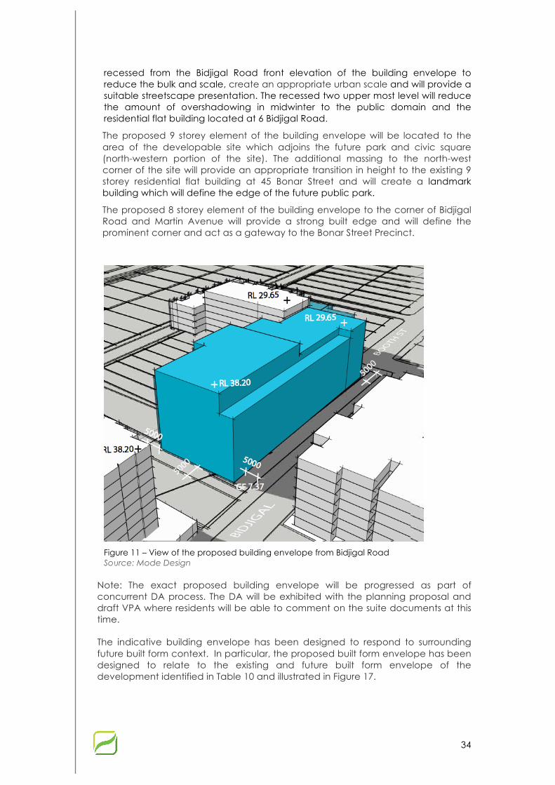
34
recessed from the Bidjigal Road front elevation of the building envelope to reduce the bulk and scale, create an appropriate urban scale and will provide a suitable streetscape presentation. The recessed two upper most level will reduce the amount of overshadowing in midwinter to the public domain and the residential flat building located at 6 Bidjigal Road.
The proposed 9 storey element of the building envelope will be located to the area of the developable site which adjoins the future park and civic square (north-western portion of the site). The additional massing to the north-west corner of the site will provide an appropriate transition in height to the existing 9 storey residential flat building at 45 Bonar Street and will create a landmark building which will define the edge of the future public park.
The proposed 8 storey element of the building envelope to the corner of Bidjigal Road and Martin Avenue will provide a strong built edge and will define the prominent corner and act as a gateway to the Bonar Street Precinct.
Figure 11 – View of the proposed building envelope from Bidjigal Road Source: Mode Design
Note: The exact proposed building envelope will be progressed as part of concurrent DA process. The DA will be exhibited with the planning proposal and draft VPA where residents will be able to comment on the suite documents at this time.
The indicative building envelope has been designed to respond to surrounding future built form context. In particular, the proposed built form envelope has been designed to relate to the existing and future built form envelope of the development identified in Table 10 and illustrated in Figure 17.

35
Figure 128 – An impression of proposed built form of the proposed building envelope from Bidjigal Road Source: Mode Design
Table 10. Built form of surrounding current/future development
The Site Status Storeys FSR
6 Bidjiglal Road (previously known as 9-11 Wollongong Street)
Built 7-8 Approx. 3:1
45 Bonar Street Built 8-9 3.1:1
63-69 Bonar Street and 27 Booth Street, Arncliffe
Approved 7 1.8:1
7 Wollongong Road Being constructed 6 2:1
The indicative building footprint and massing increase is consistent with the building height and FSR, which was previously supported by Council in relation to the site 45 Bonar Street, as part a VPA to dedicate other half of the Bonar Street Precinct Community Park to Council. The creation of a tall and articulated landmark building of high architectural quality will define the edge of Bidjigal Road and the future public park. The proposed built form has been considered in the context of the rapidly evolving nature of the Bonar Street Precinct, which is illustrated in Figures 17 and 18.
Building separation and setbacks
The proposed increase in height and FSR will enable a future residential flat building to be developed generally within the current building setback controls.

36
Notwithstanding this, a development application has recently been determined by Council for a seven storey residential flat building at the site 63-69 Bonar Street and 27 Booth Street, Arncliffe, which will have a zero lot line to the north-east of the subject site (Note: a ‘zero lot line’ means an building that is built to a/the boundary).
The Rockdale Design Review Panel at its meeting in October 2014 recommended that a zero lot line would need to demonstrate it could be integrated into a future built form at the site 8-10 Martin Avenue.
Based on preliminary architectural plans, which were prepared by Mode Design, it was demonstrated that a zero lot line at the site 8-10 Martin Avenue, to connect with the approved development at 63-69 Bonar Street, could be achieved and would be able to generally comply with the SEPP 65 Residential Flat Building Design Code rules of thumb (building separation, solar access, natural ventilation etc.).
Although the proposed residential flat building design results in a non-compliant side and rear setback, it is considered to result in a better design solution which does not result in any adverse amenity impacts to surrounding properties.
The minor Rockdale DCP 2011 setback non-compliance to the western side boundary is considered to be acceptable as adequate building separation will be provided given the location of the civic square.
Figure 13 – Area of setback non-compliance with the Rockdale DCP Source: Mode Design
Over shadowing
The location, height and bulk of the residential flat building has been designed to reduce the extent of the overshadowing to the public domain and surrounding
37
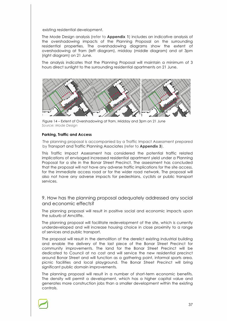
existing residential development.
The Mode Design analysis (refer to Appendix 1) includes an indicative analysis of the overshadowing impacts of the Planning Proposal on the surrounding residential properties. The overshadowing diagrams show the extent of overshadowing at 9am (left diagram), midday (middle diagram) and at 3pm (right diagram) on 21 June.
The analysis indicates that the Planning Proposal will maintain a minimum of 3 hours direct sunlight to the surrounding residential apartments on 21 June.
Figure 14 – Extent of Overshadowing at 9am, Midday and 3pm on 21 June Source: Mode Design
Parking, Traffic and Access
The planning proposal is accompanied by a Traffic Impact Assessment prepared by Transport and Traffic Planning Associates (refer to Appendix 3).
This Traffic Impact Assessment has considered the potential traffic related implications of envisaged increased residential apartment yield under a Planning Proposal for a site in the Bonar Street Precinct. The assessment has concluded that the proposal will not have any adverse traffic implications for the site access, for the immediate access road or for the wider road network. The proposal will also not have any adverse impacts for pedestrians, cyclists or public transport services.
9. How has the planning proposal adequately addressed any social and economic effects?
The planning proposal will result in positive social and economic impacts upon the suburb of Arncliffe.
The planning proposal will facilitate redevelopment of the site, which is currently underdeveloped and will increase housing choice in close proximity to a range of services and public transport.
The proposal will result in the demolition of the derelict existing industrial building and enable the delivery of the last piece of the Bonar Street Precinct for community improvements. The land for the Bonar Street Precinct will be dedicated to Council at no cost and will service the new residential precinct around Bonar Street and will function as a gathering point, informal sports area, picnic facilities and local playground. The Bonar Street Precinct will bring significant public domain improvements.
The planning proposal will result in a number of short-term economic benefits. The density will permit a development, which has a higher capital value and generates more construction jobs than a smaller development within the existing controls.

38
7.4 Section D - State and Commonwealth Interests
10. Is there adequate public infrastructure for the planning proposal?
The subject site is currently serviced with electricity, water supply, telecommunications, sewer and stormwater. The site is also well serviced by existing public transport, infrastructure and services. Further investigations will be undertaken as part of the preparation of the DA to determine whether any upgrade of existing facilities is necessary.
11. What are the views of State and Commonwealth public authorities consulted in accordance with the gateway determination?
At this stage, the views of appropriate State and Commonwealth public authorities have not been obtained. This will occur following the Gateway Determination.

39
8 Part 4 – Mapping The Planning Proposal will amend the Building Height and FSR maps in the Rockdale LEP 2011 as illustrated in Figures 21-24 (refer to Appendix 4 for further detail).
Subject site
Figure 21 – Existing Building Height map Source: Rockdale LEP
Subject site
Figure 15 – Proposed Building Height map Source: Mecone

40
Subject site
Figure 23 – Existing Rockdale FSR map Source: Rockdale LEP
Subject site
Figure 24– Proposed FSR map Source: Mecone
41
9 Part 5 – Community Consultation Community consultation would take place following a Gateway determination made by the Minister for Planning and Infrastructure, in accordance with Section 56 and 57 of the Environmental Planning and Assessment Act 1979. It is anticipated that public exhibition would include:
§ Notification on the Rockdale Council Website;
§ Advertisement in a local newspaper that are circulated within the local government area;
§ Notification in writing to adjoining landowners and neighbours, and any other relevant stakeholders and government agencies; and
§ A four week exhibition period.

42
10 Part 6 – Project Timeline This project timeline has been provided to assist with monitoring the progress of the planning proposal through the plan making process and assist with resourcing to reduce potential delays.
Table 11. Project timeline
Milestone Date Comments
Anticipated commencement date (date of Gateway determination)
July 2015
Anticipated timeframe for the completion of required technical information
Completed prior to exhibition
Updates to be made if necessary.
Timeframe for government agency consultation (pre and post exhibition as required by Gateway determination)
August 2015
Other relevant agencies to be consulted as necessary or required by the gateway determination
Commencement and completion dates for public exhibition period
August/September 2015
Dates for public hearing (if required)
Within exhibition period
Timeframe for consideration of submissions
September/October 2015
Timeframe for consideration of a proposal post exhibition
As above
Date of submission to the department to finalise the LEP
October/November 2015
Anticipated date Relevant Planning Authority (RPA) will make the plan (if delegated)
Not before November
Anticipated date RPA will forward to the department for notification
As above

Appendix 1 – Concept Design Report

Appendix 2 – VPA letter of offer
Appendix 3 – Traffic Impact Assessment
Appendix 4 – LEP Maps for FSR and Building Height
