urban areas rehabilitation planning - volume ii - the reading of the urban image
DESCRIPTION
It describes a method for reading the image of an Urban Area that allows starting its knowledge, with the aim of carrying out its overall assessment and criticism, the diagnosis of problems and opportunities that it presents and preparing proposals for intervention which achieve its physical rehabilitation and socio-economic development and the community’s cultural territorialised therein. This method develops the initial step of a methodology for planning the rehabilitation of urban areas. That methodology is described in the already published ebook “Reabilitação Urbana -Volume I - Conceitos Gerais e Metodologia de Planeamento” by the same author.TRANSCRIPT

LEITURA DA IMAGEM URBANA
URBAN REHABILITATION PLANNING
II
THE READING OF THE URBAN IMAGE
LUZ VALENTE-PEREIRAEDIÇÃO DE AUTOR
ÍNDICEAbstract - Résumé - Resumo
PREFACE
Chapter I - METHODOLOGY Objectives ���������������������������������������������������������������������������������������������������������������������������������������8Method ����������������������������������������������������������������������������������������������������������������������������������������10
Chapter II – READING THE IMAGE AND PLANNIG URBAN REHABILITATIONPlanning Methodology – Summary Table ��������������������������������������������������������������������������������������15Planning Methodology – Part I – Summary Table �������������������������������������������������������������������������16
Chapter III –PREPARATION FOR READING AND COMPLEMENTARY STUDIES The Area as Part of Urban Context ������������������������������������������������������������������������������������������������18Morphology of the Landscape �������������������������������������������������������������������������������������������������������20History of the Evolution of the Urban Fabric ������������������������������������������������������������������������������������������������������������� 21
Socio/Economic Characterization of the Population ���������������������������������������������������������������������22The Area and its Surrounding �������������������������������������������������������������������������������������������������������23Image Reading Guide of an Urban Area �����������������������������������������������������������������������������������������31
Reading Method ������������������������������������������������������������������������������������������������������������������������31Reading Record �������������������������������������������������������������������������������������������������������������������������32
Chapter IV - READING, INTERPRETATION AND ASSESSING THE IMAGE OF AN URBAN AREAComposition and Morpho-Typological Structure �������������������������������������������������������������������������36
The Basis of Formation of the Urban Fabric �������������������������������������������������������������������������������36The Occupation of the Ground ���������������������������������������������������������������������������������������������������36The Urban Fabric �����������������������������������������������������������������������������������������������������������������������39The Urban Space ������������������������������������������������������������������������������������������������������������������������55The Built-up Area ����������������������������������������������������������������������������������������������������������������������78
General Characterization of the Buildings ������������������������������������������������������������������������������81Typology of the Buildings and Households �����������������������������������������������������������������������������90The Historical and Artistic Heritage ������������������������������������������������������������������������������������������97
Composition and Active Structure �����������������������������������������������������������������������������������������������99Housing, Equipment, Public Administration and Economic Activities ������������������������������������102Traffic, Transports, Parking, Loading and Unloading, Pedestrian Circulation �������������������������107
Urban Living ������������������������������������������������������������������������������������������������������������������������������ 111Composition and Social Structure ����������������������������������������������������������������������������������������������118
Composition and Meaningful Structure ��������������������������������������������������������������������������������������124Synthesis of the Composition and Urban Structures ��������������������������������������������������������������������129Urban Furniture, Lettering, Vegetation and Animals �������������������������������������������������������������������131Urban Character �������������������������������������������������������������������������������������������������������������������������135Urban Dynamics ������������������������������������������������������������������������������������������������������������������������140Results of the Image Reading ������������������������������������������������������������������������������������������������������145
BIBLIOGRAPHY 147
Abstract - Résumé - Resumo
The Reading of the Urban ImageIt describes a method for reading the image of an Urban Area that allows starting its knowledge, with the aim of carrying out its overall assessment and criticism, the diagnosis of problems and opportunities that it presents and preparing proposals for intervention which achieve its physical rehabilitation and socio-economic development and the community’s cultural territorialised therein.This method develops the initial step of a methodology for planning the rehabilitation of urban areas. That methodology is described in the already published ebook “Reabilitação Urbana -Volume I - Conceitos Gerais e Metodologia de Planeamento” by the same author.
Lecture de l’Image UrbaineOn présente une méthode de lecture de l’image d’un morceau de ville lequel permet d’obtenir un début de connaissance globale et critique du tissu urbain en question, proceder au diagnostique des problémes et des potentialités et a l’élaboration des hypothéses d’intervention pour le réhabiliter et appuyer le développement socio-économique et culturelle de la communauté qu’y est instalée.La méthode qu’on décrit développe la partie initiale d’une méthodologie de planification de la réhabilitation urbaine publiée dans le ebook “Reabilitação Urbana - Volume I - Conceitos Gerais e Metodologia de Planeamento” de la même auteur.
Leitura da Imagem UrbanaDescreve-se um método de leitura da imagem de uma Área Urbana que permite iniciar o conhecimento desta, com o objectivo de proceder à sua avaliação global e crítica, ao diagnóstico dos problemas e potencialidades que apresenta, e à elaboração de propostas de intervenção que efectivem a sua reabilitação física e o desenvolvimento socio-económico e cultural da comunidade nela territorializada.O método que se apresenta desenvolve o passo inicial duma metodologia de planeamento da reabilitação de áreas urbanas apresentado no ebook já publicado “Reabilitação Urbana Volume I - Conceitos Gerais e Metodologia de Planeamento” da mesma autora.

PREFACE
In this publication we introduce a method of reading the image of an Urban Area which was considered appropriate to start its knowledge in order to accomplish its comprehensive
and critical assessment, pursue to a preliminary diagnosis of its problems and potentials and develop intervention hypotheses to bring about its physical and environmental rehabilitation and community development territorialized in it (Valente Pereira, 1991).
The reading method, hereinafter exposed, is an expeditious procedure to form an overall idea of the characteristics of the urban area to be rehabilitated, its problems and potential, to exercise the search for solutions to present for discussion with the different social agents and provide for the necessary means and resources to organize the studies and actions that will allow starting and continuing the tasks of rehabilitating the Area and organizing its current management. The work resulting from the reading must be presented to politicians and municipal technicians and other formal agents for discussion and decision before its enlarged and public discussion. The completion of the image reading of the Area is additionally fundamental to define and guide, integrating the sectoral studies necessary for a more objective and thorough knowledge, the studies that will develop throughout the planning process according to the information requirements that will progressively be evident. (Valente-Pereira, 1986). We are mainly looking, through the present study, to pass a set of perspectives and proposals on how we consider more comprehensive and expeditious to “grab” a part of the city in order to understand its living and changing presence, to be encouraged to assess it, to wonder about what does or does not respond to the requirements of ways and means of living in it, and in this way, cause and enhance intervention hypotheses.Our intention is not to ignore the complexity of the urban environment and find a way of working that allows capturing it in broad outline, understand it in its essential aspects and to create the necessary familiarity with the environment in which the work will be done. The syntheses to accomplish should translate this understanding of the Area, which facilitates the development of creative and integrated proposals.The registration of the peculiarities and characteristic details of the Area reinforces the possibility of building rehabilitation and expressing solutions that respect and enhance the character of the urban fabric in question.The development of the planning for the rehabilitation of an Urban Area is a complex process that requires taking into account an intricate web of procedures; the use of knowledge, methods and diversified sources of information; communication, cooperation and action of multiple social agents. This fact determines it necessary to obtain, from the beginning, an understanding of the Area and its potential for transformation, global and accessible to various stakeholders, in order to serve as a common basis from which the various studies and actions will be organized which will progressively adjust, correct and deepen the initial

knowledge resulting from the reading of the Area.It was therefore considered essential to define the issues that allow capturing and assessing the structural and most significant features and the peculiarities of an Urban Area, as well as to illustrate how to treat and relate them to inform and interpret the various contents that constitute it. These serve to build the foundation for the study and intervention, anchoring them in the specificity of the observed reality, overcoming preconceptions and standardized solutions and giving birth, from their own local conditions and characteristics, to the chances of transformation and ways of achieving them.The proposed method is intended to be open, i.e., the different categories of analysis are given as an example, since the formulation of more detailed or broad categories is admitted, depending either on the size, the complexity and other characteristics of the Area in that study, or on the understanding that the responsible technicians have of the elements that define the urban fabric.Considering the framework of the image reading in the Planning Methodology of Urban Areas Rehabilitation, previously developed (Valente Pereira 1991), in the present study we include, a summary table of the referred methodology and also an indication of the studies needed to prepare and support the image reading, in Chapter III of this publication. Issues concerning relations with its surrounding also stand out in that chapter. The study of this aspect allows overcoming an approach that, even unintentionally, tends to view the bounded area like a universe confined and autonomous in it, with the consequent distortions, both in terms of the interpretation of the present reality, and in terms of the intervention proposals.The opportunity we have been given by the Municipality of Loures of participating in the Plan for the Protection of the Old Centre of Sacavém(1), from the beginning and at consultancy level, to the coordination of the Plan has put the applicability of the method to a real case to the test.The collaboration of two grantees of the National Board of Scientific and Technological Research (JNICT) has allowed for sectoral studies to be carried out in the fields of landscape architecture (2) and sociology(3) to support the image reading and depth of the respective topics.
NOTE - The reading records selected to exemplify the urban image reading were based on the documentation that I was delivered by the Plan to Safeguard the Old Sacavém Centre
(1) Plano de Salvaguarda do Núcleo Antigo de Sacavém, coordinated by Architect Maria João Gonçalves, Urban Planning Division, City Council of Loures, 1989-1993. (2) FERREIRA, Maria Isabel CAETANO - Contribuição da Análise Paisagística para o Planeamento da Reabilitação de Áreas Urbanas - Estudo de Caso - Madragoa/Lapa e Benfica. Lisboa, LNEC, 1991. Planeamento do Desenvolvimento Sócio-Urbanístico de Áreas Urbanas
• 1ª Parte- Contribuição da Análise Paisagística no Planeamento do Desenvolvimento Sócio-Urbanístico de Áreas Urbanas. Lisboa, LNEC, 1989. • 2ª Parte- Índices de Qualidade Ambiental. Lisboa, LNEC,1990.
(3) ANTUNES, A.A. ROSA - Contribuição para a Definição das Necessidades Sociais a Nível do Quotidiano numa Área Urbana,
• 1ª Parte - Práticas Sociais Quotidianas e Apropriação Social do Espaço, Lisboa, LNEC, 1989• 2ª Parte - Utilização e Apropriação de Áreas Urbanas, Lisboa, LNEC, 1990

team, during the elaboration of the referred plan, which was supported, in its initial phase, on the image reading methodology that we present. We have added some examples of the reading, carried out at LNEC (1), of the delimited areas in Madragoa/Lapa and Benfica (Lisbon) to show how different interpretation of that reading can be.
Hopefully, it thereby enables readers to have a better understanding of the meaning and scope of the reading proposals presented.
(1) Architects José Manuel Santos, Francisco Serdoura e Maria Isabel Brito.

Chapter I - METHODOLOGY
Objectives
The image reading of an Urban Area(1) is a method of knowing the urban environment at this scale, and it aims to its assessment and to the creative elaboration of solutions
to rehabilitate it by socially, economically and culturally developing the population territorialized in it and qualifying its space.
Through the referred reading, one tries to obtain, in an expeditious manner, direct and individualized, a comprehensive, interpretive and critical portrait of the Area that allows identifying the ideas of a city, which expresses the problems that affect it, the potential it offers and to outline objectives, policies, strategies and hypothesis of action to rehabilitate and guide its transformation.It is a basic concern of this approach to the knowledge of an area to assimilate it in its entirety and dynamics, understand it both present and alive, interpret and assess it and get from it, suggestions regarding solutions and necessary actions to achieve its qualification and socio-urban development.One observes the urban image in order to:
• Identify the aspects that characterize it as a specific urban environment; • Understand how these relate to each other and how they translate the processes of
formation and urban transformation, either the spatial ones and the ways of living; • Understand what urban quality and own nature represented in it; • Identify where action is needed to solve whatever the problem is and what features and
dynamics the area owns, in order to build the transformation solutions and actions.The image reading of the Urban Area should allow the significant and rapid sketch of the present situation and its dynamics and creating the critical perspective that raises the simultaneous construction of guidelines and proposals for rehabilitation actions and urban transformation.It is a personalized reading, which is essentially sustained in the experience already gained by the technician (as such and as urbanite) and which is essential for the latter to build his own perception of the Area, to integrate himself within the reality as it is presented, to be touched and penetrated by it, clarifying his ability to understand and assess what he sees, building his own convictions, stimulators of the definition of intervention actions.The subjectivity, no comprehensiveness and quick observation make it susceptible to errors, which can be huge blunders, raise unanswered questions or with poor response. We consider that, given the listed advantages, these defects are minor and can easily be overcome in
(1) The method used is based on the proposed by ALLAN B. JACOBS and LESLIE GOULD and which is described in the document “Observing and Interpreting the Urban Environment. Case Study: Naglee Park, San José, California”, Ins-titute of Urban and Regional Development, University of California, Berkeley, WP372, 1982.

during further work and through the use of information and more rigorous analysis methods.(1)
Perceive and question reality in the presence aims, in addition to interpreting and evaluating it, at trying to find suitable answers to what should be done to rehabilitate and guide the transformation of the Urban Area. Knowledge and assessment, diagnosis and proposal are integral parts of the reading of the Area mutually arousing each other for better understanding and more responsiveness to the observation objectives.The whole cycle of the study must be traversed as a result of the latter, exercising purposeful capacity in parallel with the analysis, interpretation and assessment. It is intended, through this initial exercise, besides getting an overall understanding of the Area and its potential for transformation, that it will serve as a common basis for discussion and construction of the planning process of its rehabilitation, overcoming the difficulties of current methods of analysis that send the construction of the solutions to a subsequent stage, separating them.The common basis of information that the reading provides will have to be understandable to the various formal and informal social agents implicated and allow proceeding to the integration of their knowledge and requirements without losing but rather, correcting and enhancing a common vision and objectives of the Area and ways of its rehabilitation.Summarizing, when reading the image of the Area, one attempts to:
• Get a comprehensive, interpretive and critical portrait of the Area by setting its structural and most significant features;
• Define and locate the existing problems and potential of the Area;• Capture the urban character of the Area and the elements which express it;• Understand the ongoing dynamics of transformation in the Area;• Establish, according to the interpretation and evaluation of the results of image reading,
hypotheses concerning objectives, policies, strategies, solutions and intervention actions for its rehabilitation.
The work resulting from that reading serves as a common basis to start discussions and studies that will deepen the knowledge of the Area and will establish its planning process/rehabilitation action. It is, consequently, essential the information to integrate different disciplinary contributions and to start, in a participatory and concerted manner between the different social agents, the process of intervention.
(1) In the reading method that was the basis for the development of our work, A. B. JACOBS considers that the risks of error are reduced by:
• The multiplication of the number of observers and the confrontation and discussion of individual observation results;• Test results obtained by means of the handling and other statistical information gathered however;• The discussion of the results with knowledgeable interlocutors of observed reality.
Method
The image reading is done by direct observation. To do it, it is necessary to go through the Urban Area, see and, simultaneously, question what we see, try to relate, interpret
and assess observations (form an opinion about “what is good and what is wrong”) and map them.
While reading, comments and questions arisen by the observation, should also be registered, as well as to set out the aspects considered important to change (problems) and those which, for being very characteristic or outstanding should be maintained and may even contribute to building proposals for intervention (potential).It is important to take note of the issues that will require clarifying in future studies because they create doubts or need confirmation or further development. The observation is performed by interpreting the spatial configuration of the Urban Area, its structure and nature, ways of use and territorial appropriation by the population and activities, environments and general resulting images.Sets of observations must be interlinked in order to perceive the social structure of the space and the uses in it; morphotypologic characteristics of the Area and the links that it establishes with its surroundings; the processes of formation and occupation of the urban fabric; dynamics of the recent transformation of the area and the evolution tendencies it reveals; models and urban values underlying them; problems and their possible solutions; the potential and its exploitation.Who, where, how, what, when, to whom and for what; it is right or it is wrong, are the questions to formulate regarding the observations that will be performed, and which stimulate the ability to see and interpret what you see, to give overall intelligibility and reading, to identify and integrate the different components of the urban system, to exercise creative imagination needed to design solutions.By reading the image of the Area general perception should arise, of its urban structure, social, spatial and usage characteristics, ways of appropriation of space by people and activities.The characteristics of the Urban Area define it as a place of urban life, unlike any other and differentiated in its parts, with form and own history, the diversity of activities and social interactions that give it life. It matters to identify the invariants of the Area that have provided it a place to stay, its character or the absence of its own presence, of structuring rules that give it the right order and firm its personality.As already stated, the reading objectives aim to get “a comprehensive, interpretive and critical portrait of the area”, “the quick and meaningful sketch of the present situation and its dynamics” towards “creative elaboration of rehabilitation solutions and transformation guidance of the area “. These objectives are only achievable if, during the observation, the

morphological analysis(1) is enhanced, while complementing it with the social, cultural and functional, present and perceptible contents.The morphological analysis till requires understanding the functional and social characteristics that organized the representative forms of the past and that possibly remain maladapted to new contents, and the transformation dynamics visible in the physical and environmental changes caused by new uses, different social status of users and new cultural values.The information resulting from the reading should be mapped, labeled and illustrated (through photographs, sketches or video records) in order to translate, clearly and spatially, the results of the observation exercise.The issue of registration of information is extremely important since it indicates and expresses the perceived fundamental elements that reflect the city at that location and that are the basis of project design intervention.The exercise of reading the urban image, done in this way, does match observation and design (because the language that explains the observation is similar to the one that works out the design of the intervention proposals) and connects the analysis and synthesis of the characteristics of the Area with the building up of solution hypotheses (due to the fact that interpreting and assessing what exists presupposes the building of agglutinating relationships, developing ideas that reflect what is thought to be a “good city” and view them in the spaces under analysis).To achieve this goal, it is recommended that, for each important aspect for analysis, the procedure is such as to, besides identifying its characteristics, make it possible to assess it indicating the problems and the potential that such characteristics reveal and the intervention proposals which are believed to be able to solve the problems and enhance the identified potential. These proposals are only hypotheses arising from the analyzed issue considered and, it may be the case, as a result of the study, that they are not appropriate due, for example, to the priority of resolution of other issues whose solution is incompatible with those. The importance of its formulation lies in the register of proposals as they arise, in order that, in the final summary, they are made compatible and selected or reworked, and in fact that it compels to the exercise of constant connection between analysis, diagnosis and elaboration of proposals.It is still useful, as we have already said, to register, following the analysis, the studies that would be important to develop, in a later stage of the work, for a better clarification of the addressed issues and the topics of the extended discussion to point out, given its importance to establish fundamental options regarding the guiding concept of the city of solutions to be proposed (e.g., the place that the car takes up in public space versus the importance of the pedestrian; choices regarding the spatial structure of land, the degree of conservation/recovery of the built up, the desirability of introducing new constructions/buildings of modern architectural features in the old urban fabric).(1) The morphological analysis allows us to understand the logic of the design and appropriation of the urban fabric, define its structure, the regularities or rules and the differences and particularities that it presents, and detect the current and exceptional typologies of buildings and the urban space.

The direct observation of the image of the Area should be done separately by two or more observers. Multiplying the number of observers enriches the reading and the independence of their respective comments and it is fundamental to control deviations resulting from excesses of subjectivity and observation failures, by comparing and discussing the results. The comparison of the readings carried out by the different observers, is a first test of the performed observations and allows evidencing and assessing “ideas of the city” underlying each reading.If conflicting interpretations arise, they will be correctible, by observing aspects that created differences of interpretation again, looking to adjust them or, if this is not possible, to overcome them by using more objective methods of knowledge or accepting the diversity of opinions as real and enriching.The doubts, gaps and inaccuracies of reading are addressed, throughout the work and whenever required, by performing technical and specialized studies.The reading of the urban image should be performed by observers who possess an extensive knowledge of urban issues and of its morphological expression over the time of formation of the urban fabric.Although it matters to encourage diversity and originality of the reading of the different observers, for greater descriptive and interpretive richness of the Area, the previous elaboration of a comprehensive observation guide is considered important which, although not limiting, enables clarifying what is intended and establishes a common platform by pointing out the key issues that reading must cover in order to meet the needs of the study, and how to proceed with the registration of the observations.The comprehensive reading guide should be discussed by the planning team of the rehabilitation of the area. This discussion even allows adapting perspectives, working objectives and methodology of approaching it to the case study and to the concerns of the team. The image reading of the Area is all the more necessary as larger and more complex this one is. If the area has reduced dimensions, the reading can be replaced by a systematic survey of characteristics. In this case it is essential to proceed with a reading with greater detail of the extended territorial unity and surrounding Area in order to understand and assess its urban structure which is only readable if, in the analysis, the defined boundaries for rehabilitation intervention are overcome. These are questions that will have to be solved, casa by a case, depending on the greater or lesser morphological autonomy of the intervention area.It is essential to find a unit of observation and analysis that enables understanding the morphological structure of the urban fabric and its organizational logic, even if the territory of observation has to be extended beyond the set up intervention perimeter and, eventually, propose new limits for the planning area of the rehabilitation.

Chapter II – READING THE IMAGE AND PLANNIG URBAN REHABILITATION
The method of reading the image was developed, as mentioned in the introduction, to serve as an instrument for a proposal of methodology for planning the rehabilitation of
urban areas that we have drafted and is published.(1)
The reading of the image is, according to referred method, the first step of the technical team to know and assess the Urban Area and its transformation dynamics and build the first chances of intervention. It is the essential stage of the preparation of the technical team in order to face dialogue with other social agents involved in rehabilitation organizing the planning in itself, which takes place in terms of planning/action, namely, planning and intervening, developing studies according to the decision-making based on priorities on, and to comply with them.
(1) VALENTE-PEREIRA, L. - Metodologia de Planeamento da Reabilitação de Áreas Urbanas, Lisboa, LNEC, 1991 Reabilitação Urbana - Volume I - Questões Gerais e Metodologia de Planeamento da Reabilitação., eBook 2013

In order that the reader may know the broad outlines of the methodology presented, without resorting to the referred publications, we present, next, the overall table that summarizes the different phases of the method and the table regarding task 1 of the respective phase 1, which fits the image reading of the Area, the chosen methodology to characterize the Area. This information enables forming an idea of inserting the image reading on the proposed planning methodology. The image reading is a method that can be used to meet other objectives, such as, a preparatory study of an architectural project or a new urbanization to integrate in an existing fabric.

Planning Methodology – Summary Table
PHASES ASSIGNMENTS PARTICIPANTS RESULTS
TEC
HN
ICA
L / P
OLI
TIC
AL�
PR
EPA
RAT
ION
PRO
POSA
L FO
R P
REL
IMIN
ARY
PLA
NN
ING
AN
D P
ROG
RA
MM
ING
PU
BLIC
INFO
RM
ATIO
N
1 Formation of a technical opinion about the Area and its rehabilitation.
Technical team of local planning and Parishes.
Characterization and diagnosis. Alternative proposals for planning.Precautionary measuresIdentifying agents, media, resources and tools, for the realization of the intervention.Public information.
2 Adjustment and agreement at the municipal level of the work done in 1. First decision making.
Technical team of local planning, Parishes, municipal technicians and politicians.
Technical/political proposal of preliminary planning and programming.
Establishment of dialogue and technical/political agreement at different levels.
Decision on the actions to be implemented in the short term.
3 - Adjust and consultation at regional/central level. Second decision making.
Technical team of local planning, Parishes, technicians and responsible at municipal and central/regional level.
4 - Preliminary definition of the planning and programming of rehabilitation of the Area.
Technical team of local planning.
CO
MM
UN
ICAT
ION
A
ND
PU
BLIC
D
ISC
USS
ION
5- Organization of public communication. Preparation of necessary materials for presentation.
The different social agents that are considered appropriate after completion of the previous phase.
Local perspective on the area and their rehabilitation, bottlenecks, local development dynamics, conflicts and consensus.
Opening the ownership and responsibility of local agents and the general population.
6 Accomplishment of communication and public discussion of the preliminary planning and programming.
PLA
NN
ING
AN
D
PREL
IMIN
ARY
PR
OG
RA
MM
ING
7 - Final version of preliminary planning and programming.
Technical team of local planning.
Agents directly involved in the implementation and management of rehabilitation according to their areas of action.
Formulation of the preliminary planning.
Preparation of continuous planning action. Implementation and current management of the urban renewal area.
8-Preparation of tools for planning and management.
9- Definition of planning implementation.
10-Planning and scheduling of the actions in the short term.
PLA
NN
ING
A
ND
AC
TIO
N 11- Continuous planning through evaluation of rehabilitation actions performed, successively decided and from current management.
Chosen according to the established network of agents and the dynamics initiated by action itself.
Organized, self-controlled and instrumented dynamic of development and qualification of the territory throughout time.

Planning Methodology – Part I – Summary Table
TEMAS ASSIGNMENTS
THE
UR
BAN
AR
EA A
S PA
RT O
F TH
E U
RBA
N
AG
GLO
MER
ATE
General characterization of the Urban Agglomerate and its transformation dynamic. Identification of objectives, policies and transformation strategies - General and sectorial.
Definition and assessment of the relationship of Urban Area with its surroundings. Potential, problems and proposals for amendments.
Identification and characterization of social actors and political / administrative and financial organization capable of intervention.
Assessment of the main instruments of urban planning and management applicable to the urban regeneration.
THE
UR
BAN
AR
EA A
ND
HIS
REH
ABI
LITA
TIO
N
Characterization and assessment of the Area and its transformation dynamic. Problems, potential and elements for the construction of proposals for intervention.
Establishment of precautionary measures.
Preparation of proposals for intervention and priority intervention to be carried out in short term.
Identification and characterization of formal and informal social agents to involve in the following stages per type of intervention.
Identification of the means, methods, procedures and tools necessary to continue the study, organization and rehabilitation implementation.
Identification of the means, methods, procedures and tools necessary to continue the study, organization and rehabilitation implementation.
INFO
RM
ATIO
N A
ND
C
OM
MU
NIC
ATIO
N Dissemination to the local media of the information obtained through the study and organization of cultural animation actions.
Establishment of a public service station.

Chapter III –PREPARATION FOR READING AND COMPLEMENTARY STUDIES
Before starting the image reading of an Urban Area, and in order not to take the risk of considering it as an isolate territory, it is necessary to carry out studies and data
collections that allow knowing the area as part of the urban context and interpreting the characteristics of that belonging.
There is information about the area, not acquired by reading the image and which is essential, including preparing and interpreting the image reading. We refer the studies that enable knowing the:
• General morphology of the landscape;• History of the evolution of the urban fabric;• Dynamics of the urban transformation;• Socio-economic characteristics of the population of the Area.
The whole urban fabric is covered and read continuously, which enables knowing the relationship of the Area with its surroundings in order not to create unintended discontinuities to “sew” fabric and uses’ sequences, routes and images.The observation of the Area mapping and its Surroundings gives us an idea of the general topographical and morpho-typological features, the barriers and fabric continuities that mark the relationships between its parts and the environment. These data are important to easy orientation on the ground and to organize and interpret the reading during the observation. Knowledge of toponymy, to check and complete during the reading, helps identifying the locations which the observations refer to, and their historical meanings.The reading of the image should be done by two technicians, who know the Area, if possible, and supported by a Reading Guide of the Image of the Area which will serve as a common basis of support. To complement the reading of the image it is still necessary to do interviews with local councilors, technicians and other social agents who know the area well and its dynamics and may provide information to enrich its knowledge and have opinions regarding the prospects of its transformation. It is further desirable to develop investigative journalism to improve the information with the experience lived in the area (whose methods of anthropology approach is not always feasible, since it is time consuming and expensive) and to arouse the interest of the public. The elements of the planning team who are not busy with reading the image will however undertake the following tasks:
• Gather the material as it is available on the Area, including the existing urban infrastructure and services (cleaning, streets repairing, lighting and green areas maintenance, fire

hydrants and organization to fight fires, replacement and repairing street furniture,) and create a database of particular interest for planning and management. •
• Get the graphical cadaster of the Area. If this does not exist, its elaboration will have to be done as well as seeking to ensure its permanent maintenance through the organization of the current urban Area management.
• Get updated mapping and aerial photographs of the Area, start collecting the cartography produced over time, whether of the Area or the Urban Settlement, an initial protracting map of the Area and the record of the administrative units which it belongs to (parishes, districts, areas of jurisdiction of the Public Security Police, Firemen, zip code,). The scales 1/25000 for the Urban Settlement, and 1/10000 - 1/5000 as a basis for the reading of the Area are generally suitable.
• Carry out survey plans, programs and existing commitments, actions and projects in progress and to perform in a short term in the Area and their responsible agents. This information has the utmost interest in order to assess the dynamics of transformation that the area is subject to.
• Develop sectorial studies that are considered essential to test and (or) add information obtained throughout the reading.
The Area as Part of Urban Context
The characterization of the area as part of the context to which it belongs corresponds to a task that develops regardless of the reading, being deepened along the planning
process and discussed with the higher levels of planning, according to the requirements of the process running itself.
Sometimes, the response to the changes needed for the rehabilitation of the area creates needs for information and assistance beyond its scope, which can even be raised from the bottom up (Area for Urban Settlement) during the planning process. The information that we consider necessary to obtain before you start reading and in order to characterize the context of the area, aims to realize the situation of the Area in it, the urban roles it plays and will come to play as part of the whole which it is part of..This information regards:
• Situations of the Urban Settlement Area, the Municipality and the Region; • General landscape morphology of the Urban Settlement; • Major steps in the historical evolution of urban land use and demographic and socio-
economic development of the Settlement, the Municipality and the Region • Major axes of urban, municipal, and regional accessibility;

• General population distribution and uses of urban, municipal and regional soil; major urban centres and their hierarchy;
• Major urban areas for reasons of centrality, historical, tourist, social prestige, marginality, etc. of the Settlement, the City and the Region;
• General guidelines regarding the objectives, policies, strategies and proposals for planning of urban settlement and its parts;
• Major projects of urbanization and public works to be implemented in short and medium term, existing and approved plans, urban conditions and commitments and other indications which identify the main lines of the dynamics of transformation taking place in the urban context and impact in the area.
This information must be provided by the planning bodies of the Urban Settlement, the Municipality and the Region. At this stage of the work, it is only needed to get it in general terms and in order to be able to situate comparatively the characteristics of the Area, interpret the results of observation and structure appropriate intervention hypothesis to respond the demands and dynamics of the context in which the area is situated and which they will be reflected in. Letters and captioned schemes and its respective interpretative schemes record the synthesis of information collected and the characterization of the area arising from them. These first interpretative summaries of the context are still very useful as a basis for organizing guidance to specific studies to develop, as necessary, for further studies of the latter. It should also be noted that, depending on the area under study, the context which enables framing it will be more or less broadened as well as the importance of studies to develop. The centre of a capital city, for example, must be thought of in the light of national and international issues; a residential area situated within the settlement may waive the insertion at municipal level.

Morphology of the Landscape
A good understanding of the morphology of the landscape of the Area is essential to interpret and assess the structure of the urbanization of the Area, uncover basic
morphological problems and see how the natural potential were seized or wasted.
Madragoa/Lapa(Lisboa)
At this early stage, the participation of landscape architecture is essential as an auxiliary reading and interpretation instrument and to establish the necessary link, throughout the process and among architecture technicians about the sites, with each other and with other specialists. From the analysis of the morphology of the landscape, whose development is presented in detail in the work done in the case studies(1)we have retained, as required for direct support of reading, the definition of the topographic platforms, of the structural lines of the
(1) FERREIRA, I. CAETANO -Contribuição da Análise Paisagística para o Planeamento da Reabilitação de Áreas Ur-banas - Estudos de Caso: Madragoa / Lapa e Benfica. Lisboa, LNEC, 1991.
LINES OF CREST AND CENTERS OF DISTRIBUTION VALLEY LINES AND MEETING CENTERS
A B C D CENTERS OF DISTRIBUTION 1 2 3 4 5 6 MEETING CENTERS
landscape and slopes, as well as three-dimensional representation of the terrain, which allows getting a comprehensive view of the latter. The synthesis of this information leads to the definition of the morphological units of the landscape and its forms of articulation, which enables characterizing and evaluating the potential of urban essential features of the general morphology of the landscape and guide the interpretation and evaluation of its urbanization.
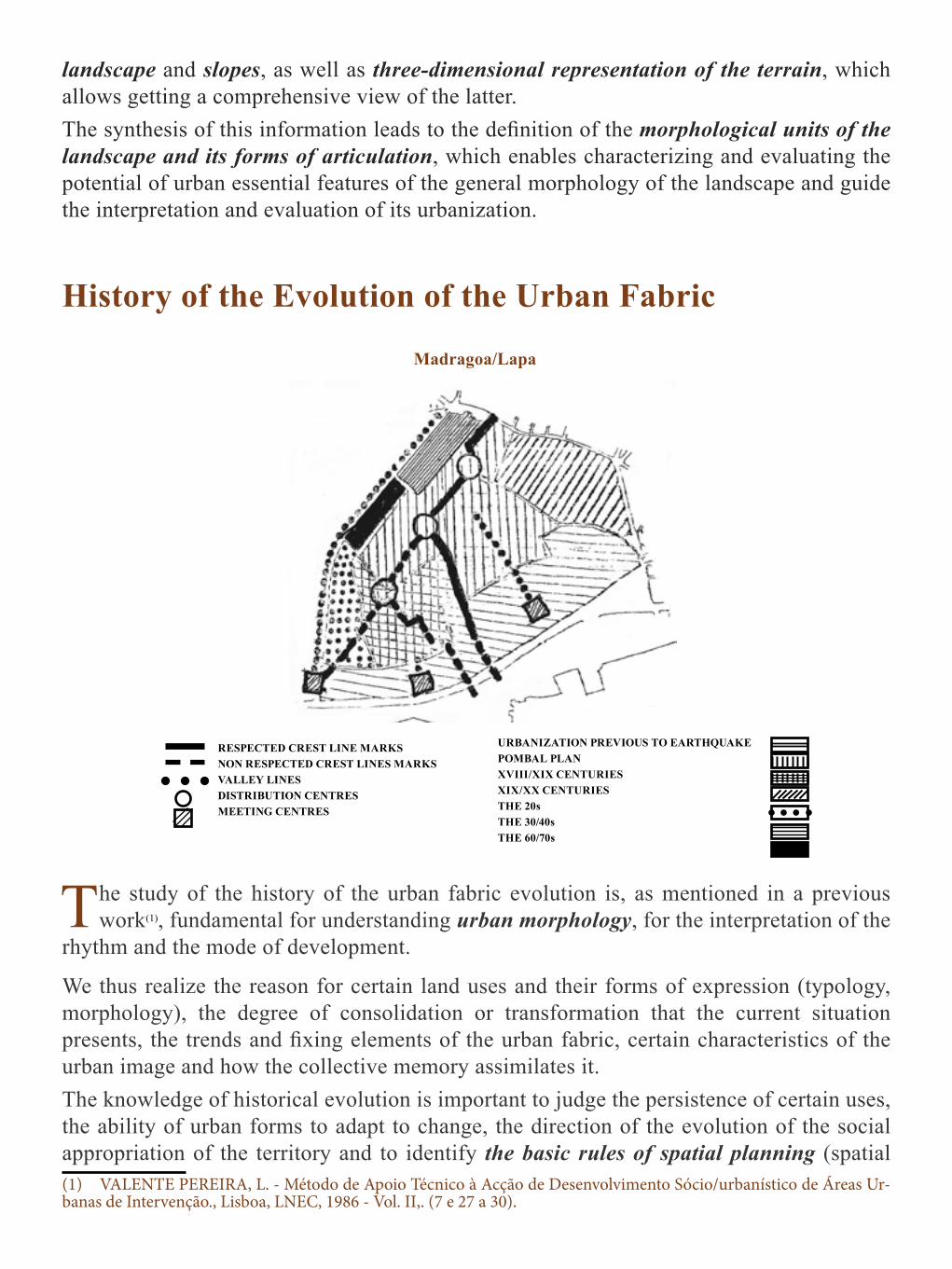
History of the Evolution of the Urban Fabric
Madragoa/Lapa
The study of the history of the urban fabric evolution is, as mentioned in a previous work(1), fundamental for understanding urban morphology, for the interpretation of the
rhythm and the mode of development.
We thus realize the reason for certain land uses and their forms of expression (typology, morphology), the degree of consolidation or transformation that the current situation presents, the trends and fixing elements of the urban fabric, certain characteristics of the urban image and how the collective memory assimilates it.The knowledge of historical evolution is important to judge the persistence of certain uses, the ability of urban forms to adapt to change, the direction of the evolution of the social appropriation of the territory and to identify the basic rules of spatial planning (spatial (1) VALENTE PEREIRA, L. - Método de Apoio Técnico à Acção de Desenvolvimento Sócio/urbanístico de Áreas Ur-banas de Intervenção., Lisboa, LNEC, 1986 - Vol. II,. (7 e 27 a 30).
RESPECTED CREST LINE MARKS NON RESPECTED CREST LINES MARKSVALLEY LINESDISTRIBUTION CENTRESMEETING CENTRES
URBANIZATION PREVIOUS TO EARTHQUAKE POMBAL PLANXVIII/XIX CENTURIES XIX/XX CENTURIES THE 20sTHE 30/40sTHE 60/70s

constants maintained throughout the variation in time).In the referred work, themes to develop in the study of the historical evolution are indicated:
• Identification of the steps of formation, filling and growth of the urban fabric; transformation of its parceling, road layout and construction; fundamental morphological characterization and main typologies of each step; significant events, elements, agents and structuring processes of this evolution;
• General characteristics and evolution of the social fabric and ownership of the Area, by the population and the activities;
• Main ideas and city models which governed the different urbanization stages of the Area.
The summary to be done should aim to portray characteristics steps without extending the description of facts, and give particular emphasis to the understanding of what the area is at present; of the processes that, when acting on it, have formed it, such as presented; the urban potential that it reveals; the own rules and constants that define its way to remain and change. Understand the role that the area was performing over time and why, within the Urban Settlement, which forms have expressed that role, the key ideas that guided that expression, the type of population that successively appropriated the area and the basic characteristics of their social status and the way of life in their relation with the space is a valuable aid to understanding the present reality and the building of its qualification and development. For immediate support for the image reading, it will be sufficient to indicate the major stages of formation and development of the urban fabric, by specializing them; the essential morphological characteristics of each stage and city models underlying them. It is important to judge the degree of consolidation of the different parts of the fabric indicating those which, over time, have been more susceptible to transformation pressures and are, therefore, more “vivid” or “fragile” and those that remained more or less intact, the most “dead” or “solid” areas. Further in the work, it may be necessary to develop studies to know the history of the buildings in detail, spaces, uses, values and customs of the population.
Socio/Economic Characterization of the Population
The method of reading the image gives, in an inaccurate way and subject to coarse mistakes, an idea of the socio-economic characteristics of the population that resides in
the Area, works in it or frequents it for any other reason.
To control this information, making it more accurate and reliable, it is necessary to develop, in parallel, the study of the available statistical data, which should be analyzed, based on the block as a reference.

The characteristics to highlight for minimally achieving economic and social characterization of the resident population relate to age, family composition and situation towards the activity, distinguishing those active and inactive, categories and occupations. This study will have to be developed throughout the work, both through the analysis of various statistical information (voter registration, data derived from the health, social security, education, police sectors,) or from direct surveys determined in accordance with the information needs that arise, along with the definition of issues of priority resolution.
The Area and its Surrounding
Through this reading, one seeks to ascertain how the Area is perceived from its exterior, to what extent it is distinguished or merges with its surroundings, which morphological
and use relations it establishes with it, how are its borders characterized and which formal consistency they have, in order to be able to conclude whether it is necessary to intervene in these aspects and, if so, build proposals for intervention.
Madragoa/Lapa Benfica
PHYSICAL BARRIERS
PERIPHERAL BOUNDERY
COTINUITY IN URBAN FABRIC
MAIN POINTS OF ENTRY IN THE AREA
CARS AND PEDESTRIANS
PEDESTRIAMS ONLY
CONTINUITY IN THE URBAN FABRIC
WELL DEFINE LIMITS
POORLY DEFINE LIMITS
GATEWAYS
ENTRIES ROUTES
VISUAL BARRIER
FIXED BARRIER
FIXED AND VISUAL BARRIER

It therefore matters to verify:• How the Area is presented, as we approach it, coming from its exterior; • Which are the morphological and use relationships it establishes with the environment,
assessing their quality and suitability; which are the forms of access to its interior and which formal consistency their borders present, i.e. whether or not these bound the discontinuities of fabric, including to assess the interest of enhancing or blurring them, through the rehabilitation intervention, closing or opening the Area to its exterior, to enhance rapid changes in urban character or the dilute through the treatment of peripheral areas, such as transitional areas.
It is still necessary to form an opinion on how the Area is integrated in the urban landscape of the settlement, which is its visibility when viewed from the outside, more or less distant, in order to conclude whether or not there is need to control its image, not only from the internal point of view of the area, but also through its contribution to the city’s image. This is an important qualification of the referred image and that does not often receive attention when making the study of the transformation of urban areas. The approach to the area is done by: .
• Performing the entry routes existing in the Area and observing the mode that this is exposed, when viewed from the outside: enlarged view over the area or impossibility to uncover it, when viewed from a distance;
• Walking the peripheral line and checking forms of access to the Area: through confined spaces between buildings, marking “gateways”, or through open spaces forming “entry areas”;
• Traversing the surrounding connection fabric the with the Area, that is, the range delimiting / distinguishing the interior of the Area from its surroundings;
• Observing the morphological and usage continuities and discontinuities which link / separate the Area of its surroundings;
• Observing the area from distant points and analyzing its contribution to the overall image of the city.
This set of observations should enable assessing the way the relations of the area with its surroundings present themselves, indicating the necessary interventions to solve any morphological and usage problems, correct formal and/ or functional disconnections prevailing in its border and defining the measures to be taken to enhance the contribution of the Area to the image of the Urban Settlement. This question, which is usually not considered, is of major importance if the Area is part of the panoramic perspective of the Urban Settlement, thus contributing to the composition of its silhouette and color. The way the Area participates in the image of the city, which it is integrated in, must be reported and discussed at its planning level and this can be an important condition of the volumetry, color and of other characteristics of the image of the Area.

PLAN TO SAFEGUARD OF THE OLD CENTRE OF SACAVÉM
1. READING APPROACH TO THE AREA1.1 MORPHOLOGICAL AND IMAGE RELATIONS
ANALYSIS
• EAST – The Area is at a higher height of land than the surroundings, surrounded by very
tall buildings that function as visual and sometimes physical barrier, creating discontinuities.
– The passage of the Area to the surroundings is done through “doors”, specific hierarchical entry/exit points.
– The image contrast between one side of the border and the other is violent / aggressive.
– The morphological relations and image are confused and conflicting, but there is however, a well-marked border consisting of buildings whose characteristics (excessive height, different architectural language and without quality) transform them into barriers and still manage problems of morphological discontinuity, “siege” and “crush”.
The Area Image Relations (Cut E/O)
The Entries in the Area Image Relations (Cut N/S)

• WEST – The Area is at a lower elevation and is surrounded by open areas, not yet built
(north and south) and that perception does not however exist, in terms of image. – In the eastern edge, the boundary is established again by much higher buildings,
creating strong discontinuities at morphological level. – The gateways to the surroundings are made in a no perceptible form, i.e., there are
no points / places that may be considered as entries / exits. PROBLEMS
• EAST - morphological discontinuities (shape, scale, architecture and image; absence of guiding elements of visual and morphological relationship with its surroundings).
• WEST - some discontinuities (shape, scale, architecture and visual); is not noticeable compared to existing open spaces.
POTENTIAL • EAST - the existence of situations of “gateways” in connection with the environment,
allowing for urban intervention in affirming this quality. • WEST - existence of free building spaces.
PROPOSALS• EAST- intervening in order to more clearly define the “gateways” to connect to the
environment. • WEST - preserving open construction space, creating green areas which establish direct
connection with the Area, both visually and in terms of usage, and that value the approach to the area.
• In general, and across the area: – To emphasize the connection with the surrounding through the location of economic
continuous activities; – To reference the Area through simple elements: for example, perceptible green
structure, taking care of the views / perceptions of the area, creating referencing landmarks.

SAFEGUARD PLAN OF THE OLD CENTRE OF SACAVÉM
1. READING APPROACH TO THE AREA1.2 STUDY OF THE ENTRIES - OLIVAL SIDE STREET
ANALYSIS • This access – through the Olival side street - seems to be little used. • It is a route where recent buildings predominate, jumbled, interrupted to the left by a
small set “hemmed” between rear of precarious, old and one-floor buildings. • The street turns to the left, leaving only then to see ahead of us a part of the Framarte
block. • Absence of sidewalks.
PROBLEMS • Pedestrian / vehicle conflict. • Different scales and languages.• Weak presence of the old area.
POTENTIAL • The following are important in defining the space: The left turn which cuts the route, the
wall of the cemetery and the small EPAL building at the beginning of the street, as well
as the hammed set between rears. PROPOSALS
• Demolition of primitive buildings located to the left (tents transformed into brick houses) and redefinition of the urban design of this area.
• Mind the interaction with the surrounding urban fabric. • Create public urban space that makes the connection to a possible pedestrian circuit link
to the existing aqueduct.

SAFEGUARD PLAN OF THE OLD CENTRE OF SACAVÉM
1. READING APPROACH TO THE AREA1.3 USE RELATIONSHIPS
ANALYSIS• There are strong and good usage relations with the surroundings, particularly at 3 levels:
– Economic activities – in the main routes connecting the surrounding areas, the most important one is the main axis of Direita Street extending to the surroundings through the Maria Luisa Braamcamp Street.
– Pedestrian Circulation - in virtually all individual connections with the surroundings and mostly longitudinally, from end to end of the area.
– Circulação automóvel - em trânsito de travessia incidindo em duas zonas da Área• The most intense relations are concentrated in two zones of the Area: Direita Street and
the central axis of nonlinear public spaces. • The way that the Area establishes relations with the surroundings and with the village,
in general, gives it a central character.
PROBLEMS • At the level of pedestrian and vehicles circulation, there are conflicting problems derived
from the size of the traffic routes that are not large enough to allow both activities. • There are no use relations with the surrounding area in a significant zone, the one in
which the Area borders with free pieces of land. • The use connections with the surrounding at North, due to economic activities, are the
weakest.
Intensity Use Relations with the Environment

POTENCIAL• There is a usage connection with the surroundings, which is generally strong. And there
is the fact that the main axis which is Direita Street/Maria Luisa Braamcamp Street matches the pedestrian circulation with the economic activities.
• The existence of a uniform and continuous set of 3 squares that is central, either in relation to the Area or in relation to the Village.
PROPOSALS • Maintain, qualify and strengthen the central character of the Area in relation to its
surroundings. • Limit / reduce the importance of vehicles circulation:
– Limit the crossing of the center by cars; – Reduce the burden of road traffic at West.
• Qualify and strengthen the connections with the surrounding areas through the treatment of linear urban spaces.
• Directing and prioritizing the interconnecting circuits with the surroundings through, namely, defining:
– The points of entry and exit; – Pavement; – Lighting, also using its intensity and color.
• Define how to make most comfortable pedestrian circulation. • Strengthen links to use in terms of economic activities and, if possible, by opening this
new route connecting fronts.• Intervene in surrounding open areas, creating an equipped green structure that provides
strong connections of use to the area.

Image Reading Guide of an Urban Area
We try to obtain in an expeditious (1), direct and personalized way, a global, dynamic and critical portrait of the Area, which allows us building an idea of its formation,
structure, characteristics and transformation dynamics, identifying problems affecting it, the potential it offers and outlining objectives, policies, strategies and intervention hypotheses to guide the rehabilitation and construction of its transformation over time.
Before performing direct observation of the Area, it is considered necessary that technicians, chosen for this task, know the general characteristics of the following elements:
• Situation and key relationships of the Area with the whole urban set which it belongs to (city / municipality / region) that characterizes it as part of this referred set and the transformation dynamic that it is subject to via this belonging;
• Topographic maps of the Area to understand the general characteristics of the land topography, the type of organization and structure of the urban fabric (urban fabric, road hierarchy, different parts and urban axes, urban typologies and of current and exceptional buildings, ... ), particularly relevant aspects of the urban fabric and other observations that are considered of interest to extract from the maps to guide the reading;
• Toponymy of the Area;• The general features of the historical evolution of the urban fabric of the area.
Doing some street interviews and with privileged interlocutors, the record of urban noises, or other types of obtaining information on site, are excellent auxiliaries for reading the image.Each observer must create their own way of approaching the area, trying not to lose sight of the objectives to be achieved and the time available.
Reading Method
The reading of the image is done through direct observation of the Area in its many aspects. We propose that the following steps are taken:
• Go through the entire Area (if possible, by car) and form a general idea of its urban structure, of the parts and main axes that define the spatial distribution of activities, types of people, buildings and other relevant general characteristics, and elaborate below, a chart reflecting the overall structure, the very relevant characteristics detected and that can also be useful to establish a roadmap of observation;
• Observe the near surroundings of the Area and how this relates to the ways of approaching (1) The time needed to carry out observation depends on its complexity rather than on the dimension of the Area and, especially, on the experience of the observer. It is considered, based on case studies and other performed applications, that an averagely experienced observer spends 4 to 8 weeks to perform the observations. Subsequent visits are generally re-quired to answer questions and obtain additional information during the record and analysis of the information obtained.

the Area and the features of the borders;• Organize, according to the perceived overall structure, walking tours that allow detailed
visiting of the Area and observing, while doing them: people and activities in spaces; public and semi-public space, its configuration and expression in three dimensions; the buildings, their typological expression and social appropriation of space;
• Interrogate and assess what is seen as we observe, relate done observations in order to be able to define, interpret, mapping and assess the characteristics of the Area regarding to:
– General Morphology of the urban landscape; – Relations of the Area with its surroundings - entries and barriers, morphological
continuities and discontinuities, functional and imaging of the urban fabric, approach perspectives, relationships of usage and so on.
– Composition and structure of the Area - people and social relationships, its values and urban meanings; the social fabric and its distribution in space; activities and cash flows; organization, expression, and urban space appropriation and the meaning of activities and places; urban spaces and the building, its morpho-typological characteristics; organization and expression characteristics; urban events. The parts, axes, urban landmarks and notable details, urban furniture and the Lettering, plant and animal species present;
– Area transformation dynamic: demographic and economic forces at work, expressed through visible changes of the building, the urban space, equipment and infrastructure, the activities and the type of population;
– Meanings and urban values, environmental features and elements that define the character of the area.
Reading Record
It is essential that the observations done on site are translated into annotated charts in order to referenciate the spaces where the observed characteristics are situated, specifying
the locations to which they relate, whether it is one street corner, a part of the Area, a set of blocks , a building, a street, a portion of it, or any other place.
The notes on the maps should translate faithfully the location of the performed observation If spatial contours are inaccurate, that inaccuracy must be indicated using, for example, the dashed dash instead of continuous, the stain instead of the contour, etc.. Annotation in the maps is recommended of the observations in a systematic way and as they occur, so that there is no loss of information, even if it does not seem relevant to the reading objectives. Upon doing the desk work of recording the analysis in chips and the interpretation of the observation, it is important to have at our disposal, not only the set of records of the

characteristics of the Area, but also of the ideas that occurred during the reading regarding the problems, potential , solutions and study themes that need to be developed immediately, because they correspond to fundamental information to interpret the reading and that this one cannot obtain (e.g. data on population characteristics, easily available in the censuses, the public transport routes, information on the historical development of the Area ...)Photographic documentation, in video or sketches should also be clearly referenced in maps and organized so as to be easily identified and consulted during the desk work.

Chapter IV - READING, INTERPRETATION AND ASSESSING THE IMAGE OF AN URBAN AREA
The image reading, as a means to convey knowledge, respecting the goals of the work, the interpretation and assessment of an Urban Area, must be formulated based on an
analytical framework that establishes the characteristics considered to translate the observed reality and its transformation dynamic.

We intend a broad portrait, we would say almost a caricature, to the extent that a good caricature clearly defines the caricatured with great economy of means and clearly accentuating the essential features and the significant details that express it.Our proposal of analytical framework concerns the following aspects:
• Composition and structure of the Area, resulting in the synthesis of information relating to:
– Composition and morpho-typological structure; – Composition and active structure; – Composition and social structure; – Composition and meaningful structure;
• Urban furniture and lettering, plant and animal species; • Urban character; • Urban dynamics.
The synthesis of information that elucidates these items will enable knowing in its essential aspects, the Area and its transformation dynamic and proceeding to its interpretation, detecting the main problems and potentialities of the Area and thus obtaining the information that contributes to the construction of alternative possible solutions hypotheses of the first and of exploration of the second, i.e., defining actions that lead to the rehabilitation of the Area.

Composition and Morpho-Typological Structure
Under this heading, it is intended to gather the information needed to characterize and interpret the urban space in three dimensions (or even four, i.e., including the time of
routes in it and the consequences in their perception), understand how it is organized and what features define it as a constitutive element of the Area.
To accomplish these goals, we have organized the information in order to be able to know, interpret and assess:
• The bases of formation of the urban fabric. • The occupation of the ground. • The urban fabric. • The urban space. • The buit-up area .
The Basis of Formation of the Urban Fabric
The passage of a rural to an urban place is done by interpreting the rural landscape in the light of the idea of the city that existed at the time of that conversion and according to
the corresponding way of urban production.
The structural elements of the urban fabric are defined based on the morphology of the landscape of the place and the historical evolution of the composition of its fabric marking, reinforcing or undoing urban outlines and the existing division of property according to the successive demands of urbanizations and the city concepts that gave it information.The assessment of how urbanization has been done and the elements that mark it, of the ability to properly master the morphology of the local landscape and to “sew” the successive interventions is an essential step to guide the definition of proposals to develop in order to maintain and establish the existing structure, to remedy it, or to define it, if the fabric is unstructured or maladapted to the morphology of the place.
The Occupation of the Ground
In this section, we refer the quantitative information that is deemed appropriate to define the general occupancies of the ground of different types of uses (built-up ground, public
space and private outdoor space) which will assess densities and types of occupation and ground availability.
These indices should be determined per areas that have morphological homogeneity characteristics, especially if the Area presents very distinct parts, and assessed by comparing

them with the corresponding average values of the Settlement, with the recommended national and international values and limit values existing in the Area.If it is considered relevant, at this stage, the indices referred to other ground uses and more detailed than those indicated, will be calculated.
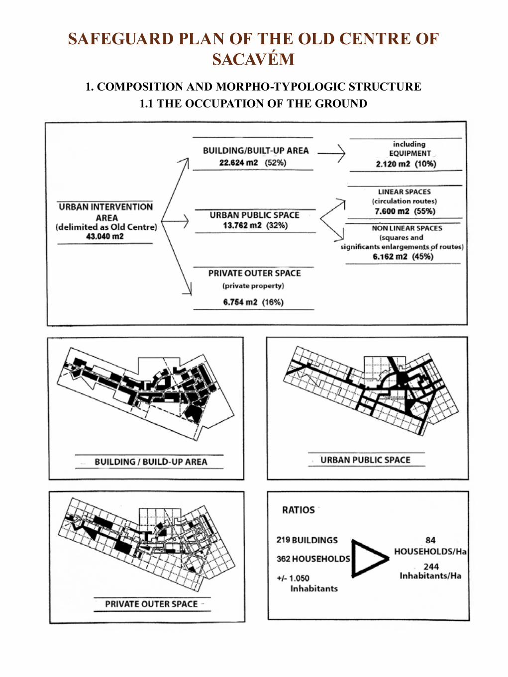
SAFEGUARD PLAN OF THE OLD CENTRE OF SACAVÉM
1. COMPOSITION AND MORPHO-TYPOLOGIC STRUCTURE1.1 THE OCCUPATION OF THE GROUND
The Urban Fabric
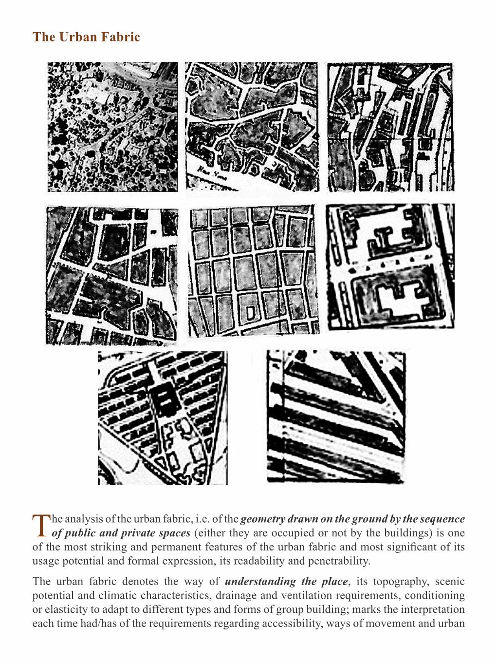
The analysis of the urban fabric, i.e. of the geometry drawn on the ground by the sequence of public and private spaces (either they are occupied or not by the buildings) is one
of the most striking and permanent features of the urban fabric and most significant of its usage potential and formal expression, its readability and penetrability.
The urban fabric denotes the way of understanding the place, its topography, scenic potential and climatic characteristics, drainage and ventilation requirements, conditioning or elasticity to adapt to different types and forms of group building; marks the interpretation each time had/has of the requirements regarding accessibility, ways of movement and urban

residence, to the resolution needs of the building and private open space and hierarchy and meaning of places.To analyze, interpret and assess the urban fabric it was considered necessary to observe:
• The designs and their dominant orientations, revealing the position of the fabric on the ground, the building elements of its geometry, of the continuities and discontinuities of the fabric;
• The geometry drawn by the fabric, indicating the diversity or homogeneity of the fabric, its configuration by unit or differentiated parts, the articulation or disarticulation existing between the parts, the formal / positional hierarchy of the elements that make it, the constraints affecting the definition of the division of property;
• The framework formed by linear public spaces (spaces characterized by the marked accentuation of the size of the axis corresponding to the length, forming “channel spaces”). This framework defines the possibility of irrigation of the fabric, of orientation changes of routes and the type of accessibility created. How the linear public spaces position themselves, relate and rank within the Area and extend or interrupt beyond it, allows understanding the structure it translates:
– The mode of urbanization of the place in terms of internal and external accessibility; – The different attractiveness regarding the location of the activities; – The definition of calm and internalized areas or areas open to the outside and
points or axes of internal convergence; – Sequences and disruption of route of the different road hierarchies; – The adaptability that it provides to the deployment of different types of urban
buildings.Through the analysis of this feature, it is possible to assess the coherence and appropriateness of the urban design to meet a clear, structured urban settlement and adapted to the topography and its use potential. The design of the framework can present itself unstructured or, though revealing a structure, define accessibilities and hierarchies that are not fulfilled on the ground due to the design of the pathways that embody it (it is the case of some urban designs in Madragoa) or have a semi-destroyed structure, due to interventions that, closed within their own logic, forgot to meet the structure defined in previous rural or urban occupations (as it is the case of Benfica). The fabric, depending on its design, may or may not, provide for a wide range of uses without changing itself and without restricting them.
• The structure of the nonlinear relationship public spaces (spaces characterized by little difference in size between its various axes). The structure of the relationship of these spaces shows how they were interpreted:
– The demands of the public stay, – The concentration or dispersion of these spaces in the fabric,

– Its hierarchy, – Its importance or marginalization in defining or strengthening the structure of the
urban fabric, – The ordering elements of its positioning and formal development.
The analysis of this structure allows assessing the balance that the distribution of nonlinear public spaces has in the fabric and decide whether or not there is the need to create, extend, delete, or define the hierarchy of this type of spaces.
• The hierarchy of non-linear public areas, stay areas, refers its importance, not only regarding the Area but for the whole city, or at national and even international level(1) and has mostly to do with the excellence of the architectural treatment, but historical issues, usage, size and positioning in the tissue are also important.
• The purpose of this analysis thus encompasses, not only the perspective of local usage, but also aspects of meaning and form in general urban context, if the Area under study, or any space in it, have importance at this level.
• For proper knowledge and strengthening of the propositional capacity regarding urban space, we consider essential giving to non-linear public spaces (stay) the same relevance that has been given to linear public spaces (circulation) in terms of their study and resolution, even defining structuring hierarchies of their use and meaning..
The interpretation and evaluation of urban fabric is a key step to understanding and assessing the Area, to diagnose the consistency and the potential of an urban fabric, proceed with the verification of its suitability to the ground and build solutions to correct deviations and deficiencies of the existing stroke or, assuming the absence of an ordering structure, proceed to its creation giving coherence and legibility to the urban fabric.
(1) As an example, Terreiro do Paço, (Lisbon) and Praça de São Marcos, (Venice) are herein referred as having clear importance, both at national and international level, respectively.

COMPOSITON AND MORPHO-TYPOLOGICAL STRUCTUREThe Urban Fabric
Orientation of the urban design, types of fabric and their articulationLISBOA (Madragoa /Lapa)
MADRAGOA/LAPA (LISBOA)
Madragoa/Lapa (Lisboa)

CHARACTERIZATION • The urban fabric is oriented according to the main lines of terrain relief and presents a
reticulated of routes, sometimes dense, scarce squares and plazas located in the peripheral perimeter of the area.
• It forms an irregular grid that is organized by being supported by linear peripheral developments.
• It is characterized by having large blocks that interrupt design continuities, due to the narrowness and weak hierarchical road.
• Does not establish continuity relations with the surrounding tissue and S. W • Arranges-forming sets of similar blocks, grouped together and which define different
areas about the potential use and occupation of land. • It is a fabric that closes itself to the outside.
POTENCIAL• Structured, readable, well-watered fabric, facilitating the change of orientation of the
routes, defining various areas despite their overall unity. • Rather varied dimension of the blocks. • Fabric that is closed to the outside providing a peaceful and secluded setting in the heart
of the city. • The orientation of the fabric enhances the visual enjoyment of the river.
PROBLEMS • Discontinuities by mismatch of the square grids, multiple crossings, narrowness and
variation of the profiles of the routes, barriers along wide ranges of fabric and poor penetration in relation with the outside.
INTERVENTION HYPOTHESES• Keep the characteristics of the fabric and its impenetrability, preventing the installation
of usages that are incompatible with it or
• Perform deep changes to facilitate crossings N/S and E/W and the penetrability of the fabric and provide new usages.
TOPICS OF DISCUSSIONAdvantages and disadvantages of the weak hierarchy of the routes, of interiority and opening to the outside of the fabric. Suitability of this type of fabric to the installation of economic activities, interests and possibilities of their adaptation to ensure the circulation and the parking.

STUDIES TO DEVELOPComparative study of identical urban fabrics and different times, checking its variation and that of the of the types of use, shapes and densities of the terrain occupation that they accept.

COMPOSITON AND MORPHO-TYPOLOGICAL STRUCTUREThe Urban Fabric
Orientation of the urban design, types of fabric and their articulationLISBOA (Benfica)
Benfica (Lisboa)

CHARACTERIZATION• The urban fabric develops supported on a central axis oriented E/W coinciding with the
valley and which the linear developments N and S are perpendicularly supported in. • This structure is partially destroyed due to the implementation of housing developments
that organized ignoring it and occupying large open and irregular blocks penetrated by local access roads with dead ends and where the buildings are arranged as separate units.
• The unstructured fabric is emphasized with the existence of large areas including farmlands, expectant lands, parks, sets of isolated buildings and a cemetery.
POTENCIAL• The valley and the roads crossing N/S mark a clear structure, adapted to the terrain,
which should be exploited in order to organize the fabric. • The existence of expectant land and numerous spaces between, formally undefined, can
be used to “sew” fabrics and structure the urban fabric.
PROBLEMS • Fabric with strong discontinuities and uncertainties and it looks divided. There is lack
of structural elements that “grab” the changes of this type of fabric. The central structure (E/W ax and perpendicular roads) is interrupted and incomplete.
• The fabric establishes weak relationships with the surrounding given the existence of barriers (E and W), large areas of land with little or no public pervasiveness of high-traffic roads and partly elevated.
• The special connection that the valley establishes with the periphery and center of Lisbon is poorly explored.
INTERVENTION HYPOTHESES• Strengthen the basic structure of the preexisting fabric and redefine ordering elements
with particular attention to the transition areas between the types of fabric and those of relationship of urbanizations with each other and with the referred structure.
• Enhance and clarify relationships with the surroundings (N/NE and through the valley). • Solve the usage and occupation of the interstitial spaces and the expectant ones. • Solve the circulation problems and superimpose a green fabric that may be a structural
alternative.
DISCUSSION AND STUDY THEMES • Types and functions of the existing urban fabric (circulatory scheme versus organizing
element of construction and urban design).• Solutions that enable the structuring of a fragmented urban fabric.

SAFEGUARD PLAN OF THE OLD CENTRE OF SACAVÉM
2. COMPOSITION AND MORPHO-TYPOLOGIC STRUCTURE 2.3 URBAN FABRIC
A) GUIDELINES AND TYPES OF FABRIC AND ITS ARTICULATION
ANALYSIS• Two types of urban fabric are identified: LINEAR and ORGANIC. • These fabrics articulate themselves through an axis of urban spaces formed by the set of
squares 5 de Outubro, Pedro José Gomes and 1º de Maio. • The linear fabric is East/West oriented and the organic one is situated in the North/East/
South quadrant. PROBLEMS
• LINEAR URBAN FABRIC in the border areas: the morphologic relationships with the surrounding area are poorly defined.
• ORGANIC URBAN FABRIC creates labyrinthine circuits and with no sense of direction advisor and allows poor legibility of urban space; it is not attractive for the implementation of economic activities or equipment by the conditioning of readability, size and circulation that it imposes; it generates residential areas with sanitation problems, lighting and ventilation.
ORGANIC FABRIC
LINEAR FABRIC
AXIS AND ARTICULATION

POTENCIAL • LINEAR URBAN FABRIC has a strong sense of direction and hierarchy, provides good
legibility of the urban space, with good accessibility, allowing different uses in terms of the buildings: economic activities, housing, equipment.
• ORGANIC URBAN FABRIC provides diversity of public spaces in terms of type, size and diversity of routes.
PROPOSALS • Keep the types of fabric and its articulation. • Complete the built-up areas (west blocks) for better definition of the linear fabric. • Effecting occasional interventions in the organic fabric to solve health problems.

SAFEGUARD PLAN OF THE OLD CENTRE OF SACAVÉM
2. COMPOSITION AND MORPHO-TYPOLOGIC STRUCTURE B) DISTRIBUTING NETWORK OF LINEAR SPACES
The Area in Sacavém fabric Distributing framework of linear spaces
ANALYSIS • The distributing framework of linear urban spaces was analyzed in the context of the
urban settlement and under 4 categories: the routes connecting to the outside, the overall distribution routes, local access roads and footpaths.
• The Area is crossed by general distribution routes connected to the external road network, with particular focus on Central and West zones.
• The central zone has a “ring road” of local access routes whose interior is connected by a set of footpaths. The central role of the area is confirmed in relation to the urban agglomeration.
PROBLEMS • The accessibility arising from the fact that the Area is traversed by important general
distribution routes connected to the outside is not accomplished in what regards road traffic due to its excessive load compared to the structure/size of the roads.
• Excessive road traffic.
POTENCIAL• Central role of the Area in relation to the urban agglomerate.• Good accessibility and coverage, due to the varied type of distribution networks: central,
CONNECTING ROUTES TO THE OUTSIDE GENERAL DISTRIBUTION ROUTES LOCAL ACCESS ROUTES WALKING PATHS
connection to the outside, local and pedestrian. • Existence of a large number of pedestrian pathways.
PROPOSALS• Keep and enhance the distribution network, the quality of its structure, which allows
organizing sequential routes through different spaces • Keep the sequential structure. • Upgrade the existing hierarchy. • Broaden the 5 de Outubro Square and accentuate its role in the hierarchy of the distribution
network, emphasizing its central organizing function.

SAFEGUARD PLAN OF THE OLD CENTRE OF SACAVÉM
2. COMPOSITION AND MORPHO-TYPOLOGIC STRUCTURE 2.3 URBAN FABRIC
C) DISTRIBUTING NETWORK OF NONLINEAR SPACES
Non Linear Public Spaces Organization of Public Spaces
ANALYSIS • Hierarchically there are 3 categories: the central set formed by three wider squares, of
which 5 de Outubro Square is the most important, the significant enlargement of the routes along the longitudinal axis, and the small squares and small significant enlargements of routes, that focus on the organic fabric.
• There is a clear hierarchy of nonlinear urban public spaces: – Central Zone, 1st order (2) formed by a succession of squares corresponding to a
sub-group of hierarchies as follows: firstly, 5 de Outubro Square, secondly 1º de Maio Square and thirdly, José Pedro Gomes Junior Square.
– West Zone, 2nd order (1) formed by a succession of enlargements of pathways of roughly equal importance where the no. 1 of Almirante de Reis street assumes the most significant role.
– East Zone, 3rd order (3) consists of a set of small squares whose importance between each other is equivalent.
PROBLEMS • There are no problems regarding the distribution framework of nonlinear public spaces
but, with the exception of those located in the organic nucleus (East), all spaces are crossed by car traffic in a disorderly manner and very high frequency.
POTENCIAL• This distribution network is hierarchical, organized, structured, is sufficient and covers
the entire area
PROPOSALS • Conserve and enhance the distribution framework, the quality of its structure, which
allows the organization of sequential pathways through different spaces. • Keep the sequential structure. • Upgrade the existing hierarchy. • Broaden the 5 de Outubro Square and accentuate its role as the main framework hierarchy
and emphasize its central organizing function.

SAFEGUARD PLAN OF THE OLD CENTRE OF SACAVÉM
2. COMPOSITION AND MORPHOTYPOLOGICAL STRUCTURE2.3. URBAN FABRIC – SYNTHESIS
SYNTHESIS• The Area is formed by two types of fabric that develop oriented W/E clearly identifiable
(organic or linear) and which articulate themselves through a set of 3 nonlinear public urban spaces in succession, forming a vertical NW/SE axis.
• It is an urban fabric well irrigated by nonlinear public roads and spaces, whose distribution frameworks are hierarchized, complete and varied.
PROPOSALS • Keep the two types of urban fabric and its articulation, which is achieved through non-
linear urban public spaces. • Fill with buildings the Southern area of the linear urban area in order to close off/ build
rectangular closed blocks, rectangular type. • Assess the possibility and the interest of opening a one-way street in the back South of
LINEAR URBAN NETWORK
ORGANIC URBAN FABRIC GERAL DISTRIBUTION NETWORK LOCAL DISTRIBUTION NETWORK NON LINEAR PUBLIC SPACES
REDE DE LIGAÇÃO AO EXTERIOR

the linear urban fabric blocks in order to close off / keep street fronts and keep the car centrality creating alternatives to the existing road circulation.
• Reinforce and enhance the articulation of the urban fabrics of the Area with the surrounding urban frameworks, in order to accentuate the character of the city center.

The Urban Space
The set of public spaces are organized sequentially, irrigating the territory. Its relationship structure, the urban fabric, shows how the urban appropriation of the place was done
and how were the relationships with its enlarged exterior established.
In addition to the urban fabric, support web and organization of the urban fabric formed by the public spaces, the urban space also includes outer spaces whose formal definition /poisoning in the fabric defines them as semi-public and private spaces. These designations refer, in this text, to morphologic characteristics rather than to the property status (which does not incidentally include semi-public spaces).

The private urban space owes its status to its formal inaccessibility (closed by construction) whereas the semipublic is classified as such because, though formally accessible, since the built area does not close it off, the way how the access expresses itself formally creates doubts on whether in enters in it unconditionally, shows the concern in connecting it to a restricted group of users, to close / hide it in order to give it a certain privacy that enables presupposing particular usage and appropriation rules. Public, semi-public and private urban spaces, form the urban space, and are integral categories that organize the analysis of the urban space as an object in itself, as architectural space, as a concrete, individual and multidimensional form, defined to answer to the needs of collective and individual usage in the broad sense of ownership, enjoyment and representation. On a first approach, it will be our concern to group the urban spaces according to their marked physical characteristics of their possibilities of usage, which point to the definition of different typologies. It will matter grouping the linear public spaces according to the characteristics of its transversal profile in three dimensions, which indicates the type of circulation it allows and points out the characteristics of the channel space that it defines. The nonlinear public spaces will be classified according to the type of pavement and whether or not there is urban furniture adequate to the urban stay, these characteristics marking usage intentions and also the issues related to its dimension and urban hierarchy. Different designations related to its landscape design/use (garden, park, market garden, vacant land…) will stand out in what regards non paved and mixed spaces. The analysis of the activities in the public space will allow posterior conclusion about the adequacy or inadequacy of the latter to those and also about the need for intervention in one or in the other in order to have a good urban balance.As to semi-public outer spaces, the survey conducted in the case studies (Madragoa/Lapa and Benfica - Lisbon) enabled identifying courtyards and villas, designations taken from toponymy and which have great formal diversity and have the common feature of being situated in the inside of the blocks by directly accessing the public road through spaces of entry in hallway jammed into the building. These spaces allow public access to buildings that would otherwise be directly inaccessible, as they are located inside the blocks. The outer private spaces should be grouped with identical goal: facilitate the understanding of the variety of typologies represented for further assessment of the adequacy of forms to the existing usages and the consequent need to change any of them in case there are major imbalances that must be corrected by the intervention of rehabilitation.In the case studies referred to, the outer private spaces can be grouped into the following types: garden/yard, lobby, patio and “campus” that fit various public administration buildings still emerging an agricultural property in Benfica.The typological definition of outer spaces is an understudied topic. The current designations that we have adopted point out different typologies, with ambiguities and inaccuracies, and evidence the practical need to refer the form and usage of places in typological terms.

From the case studies we have done, we have withdrawn the classifications that we indicated which we consider helpful for the understanding and morphological assessment of the Area to which they relate. They are only valid as exemplification. In each analyzed new case it will be necessary to determine which classification best fits the type of fabric and the objectives of its knowledge and assessment, proceeding to the respective definitions.The urban space is, as we have said, to be observed and analyzed as architectural space, i.e, as a formally defined space in three dimensions, as internal space bounded by the pavement, façades or green curtains, mountains, sea and sky, where activities and behaviors happen, which contains/carries out urban life, which produces feelings and emotions and conveys meanings.One of the essential aspects of reading the urban image regards the concern to observe and analyze the urban space as an object in itself, inhabited and with its own shape, not only considered as an organizing/distributing framework of the urban activities. Its shape should not be the result of the sum of spatial answers single defined in accordance with each project of buildings and their outer arrangements, but rather be the object of the design itself in the urban fabric set, in order to enable the study and definition of a coherent image of the spatial sequences that go through the Area, which may be subject to discussion and serve as a working basis for the different designers who will make it real through their projects. In view of the analysis of the urban space as an architectural object, a data page must be prepared for the record of information that is considered necessary to characterize and assess it in order to define and inform the rehabilitation project and urban qualification that it should be subject to. It is an analysis that requires proceeding to a first delimitation of the sections in the urban continuum that the public space forms.That outlining must be done in such a way as to define:
• The sections of the homogeneous spaces, that is to say, those that, due to its formal and functioning definition, its unity, diversity or in definition of its urban character should be unities subject to the same urban rules;
• The sections of interfaces that perform or should perform the connections between spaces of different urban character and that may require the intervention of a project in order to perform the referred connections;
• The places or sections where it would matter to do any changes of urban character to break the monotony, define urban milestones or/and create structuring elements of an amorphous or uncharacteristic urban image, perform demolitions to sanitize or give way to other uses not taken into account in the existing fabric...
The delimitation and characterization of sections in the urban continuum formed by the public space express, operationally to the project: the image reading of the area, interpreting it; reveal the basis of the guiding criteria for its conservation, structuring and reconstruction and prepare the definition of the rehabilitated/qualified image, that is to say, the realization, within the space of each defined section, of the program and urban regulations that will give information to the projects of physical intervention.

It is, therefore, a work that should be undertaken in the final stages of reading, analysis and interpretation of the urban image but that matters preparing early and completing successively and in a more or less complete and accurate way, depending on the scope and priorities of intervention that will be established, in accordance with the existing political decisions, financial availability and the achievement potential.

SAFEGUARD PLAN OF THE OLD CENTRE OF SACAVÉM
2. COMPOSITION AND MORPHO TYPOLOGICAL STRUCTURE 2.4 THE URBAN SPACES
A) LINEAR URBAN PUBLIC SPACES
ANALYSIS • After analyzing the linear urban spaces we are brought to the conclusion that there are
three types of them, depending on the profile and relationship between them and the height of the buildings that define its street façade and the activities that they enable doing.
• The meeting and social interaction places are situated in the two main axes of the Area: – STREETS – linear spaces whose relationship between the profile and the height
of the adjacent buildings is balanced and that, generally, allow traffic circulation, only in one direction, but compromising the comfort of the pedestrian circulation;•
– STREETS OF CONFRONTATION - linear spaces on the periphery of the Area which we highlight because it is found that the relation between profile and height of adjacent buildings is unbalanced, either by excessive buildings’ height or the difference of height between the two street fronts:
– SIDE STREETS - particularly narrow linear spaces, which only allow pedestrian traffic, and whose heights of buildings that confine them are significantly balanced.
• The main types of linear urban public spaces are organized in the urban fabric clearly and, naturally, linked to the types of urban fabric: the ‘side streets’ focus on the organic fabric, the “streets” on the linear fabric and the “streets of confrontation” on the limits of the Area, in the areas of juxtaposition with the modern urban fabric.
SIDE STREETS STREETS STREETS OF CONFRONTATION

CONCLUSIONS • It is necessary to intervene in the streets of confrontation in order to balance between the
image and the surrounding area• It is necessary to remove the traffic of certain streets in order to favor the pedestrian circulation.
• It is not possible to provide the linear urban public spaces of the Area with a green structure of trees.
• In the streets where it is necessary to keep car traffic, sidewalks with curbs should not be implemented, but rather different types of flooring should be adopted, always valuing the pedestrian comfort.

SAFEGUARD PLAN OF THE OLD CENTRE OF SACAVÉM
2. COMPOSITION AND MORPHO-TYPOLOGICAL STRUCTURE 2.4 THE URBAN SPACES
A) LINEAR PUBLIC URBAN SPACES THE STREETS
ANALYSIS• Pedestrian and vehicles circulation urban spaces. • Spaces that favor the implementation of economic activities. • Balanced spaces that favor comfort to the pedestrian.
PROBLEMS• Of the pedestrian/vehicle conflict due to the dimension of the profile. • Of the discomfort due to the inexistence of sidewalks. • Of cleaning (deficient) and of garbage collection (that requires garbage containers). • Of insufficient public lighting. •• Of the access of certain type of vehicles: firefighters, garbage and cleaning.
POTENCIAL• Directional quality. • Formal quality of a large number of buildings’ façades. • Favors walks and casual meeting. • Favors the implementation of economic activities.
PROPOSALS • Remove the car traffic or limiting it to one direction only. • Arrange pavement, without sidewalks, and use differentiation of materials. • Intervene in the existing built up, improving the quality.

SAFEGUARD PLAN OF THE OLD CENTRE OF SACAVÉM
2. COMPOSITION AND MORPHO-TYPOLOGICAL STRUCTURE 2.4. URBAN SPACES
A) LINEAR PUBLIC URBAN SPACES THE STREETS OF CONFRONTATION
ANALYSIS• They are spaces whose profiles are very unbalanced, with street fronts that are also
unbalanced, either in terms of volumes, or of formal language. • They act as the limit of the Ancient Centre. • They, generally, allow pedestrian and vehicle circulation.
Emphasis was placed on this group of linear urban public spaces of the other “streets”, as they mark the boundary between the two urban fabrics - the “new” and the “old”.
PROBLEMS • Volumetric and formal imbalance between the two sides of the urban space.• Excessive intensity of the traffic. • Conflict pedestrian/vehicle due to reduced dimension of the profile or absence of
sidewalks. • Insufficient public lighting. • Discomfort for pedestrian circulation and activities connected to the stay.
POTENCIAL• They could enable establishing the transition between the old and modern fabric, if they
were not completely built. PROPOSALS
• Implementation of the road plan to ordain and qualify the uses and urban spaces.• Ordain or remove the car parking on the streets. • Create comfortable dimensions for pedestrian circulation and stay. • Insert green structure when the profile allows it.

SAFEGUARD PLAN OF THE OLD CENTRE OF SACAVÉM
2. COMPOSITION AND MORPHO-TYPOLOGICAL STRUCTURE 2.4 URBAN SPACES
B) NONLINEAR PUBLIC URBAN SPACES JOSÉ JOAQUIM RODRIGUES SQUARE
CHARACTERIZATION • Little space of well-defined and regular shape, situated on an elevation above the road• Quadrangular clenched space, with only one side open to a linear public side space
whose access is done by ladder. • This setting and the relationship it establishes with the linear public space give it a semi-
public character. • It does not have equipment that promotes and enables activities of stay. • TYPOLOGY: non-linear urban public space.• ACTIVITIES: housing, tertiary (office), car traffic (peripheral) and pedestrian circulation
(crossing), parking (peripheral). • PAVEMENT: Portuguese sidewalk.
• COLORS OF THE FAÇADES: white and dark red. • LETTERING: undefined, disorganized. • DETAILS: fountain located in the center and surrounded by 4 flowerbeds, access stairs
to the buildings, tile panel.

SAFEGUARD PLAN OF THE ANCIENT CENTRE OF SACAVÉM
2. COMPOSITION AND MORPHO-TYPOLOGICAL STRUCTURE2.4 URBAN SPACES
B) NONLINEAR PUBLIC URBAN SPACES JOSÉ JOAQUIM RODRIGUES SQUARE
Interconnection with urban spaces and entrance to the buildings
Activities of Traffic and Parking
(Location / number of parking places and traffic routes of vehicles)
Urban Furniture
1 lighting lamp, waste containers, 1 pole of public electricity
Crossing and Meeting Activities (Meeting and socializing points, pedestrian
circulation axes))

SAFEGUARD PLAN OF THE OLD CENTRE OF SACAVÉM
2. COMPOSITION AND MORPHO-TYPOLOGICAL STRUCTURE 2.4 URBAN SPACES
B) NONLINEAR PUBLIC URBAN SPACES JOSÉ JOAQUIM RODRIGUES SQUARE
HISTORICAL NOTE• The square J. J. Rodrigues is composed North the buildings adjacent to the set of Side
Street – Travessa das Prioras, not later than century XVIII. The building has two floors with uniform spans, having in the façade of the western body, facing south, a French window with wrought-iron balcony. Building of stone windowsill and frame moldings in the spans. (1)
• East is located the building of workers’ housing dated 1902 with running gallery in
the back, currently made of concrete and, primitively, of wrought-iron (traces of it still remain). (2).
• South of the Square there is a warehouse - 30/40 years (3) - adjacent to the XIX century portal that led to the former Quinta da Vitória (4).
• West of the Trigueiros Martel street and the South of the side street - Prioras side street is located a large new building of square (5) plan.
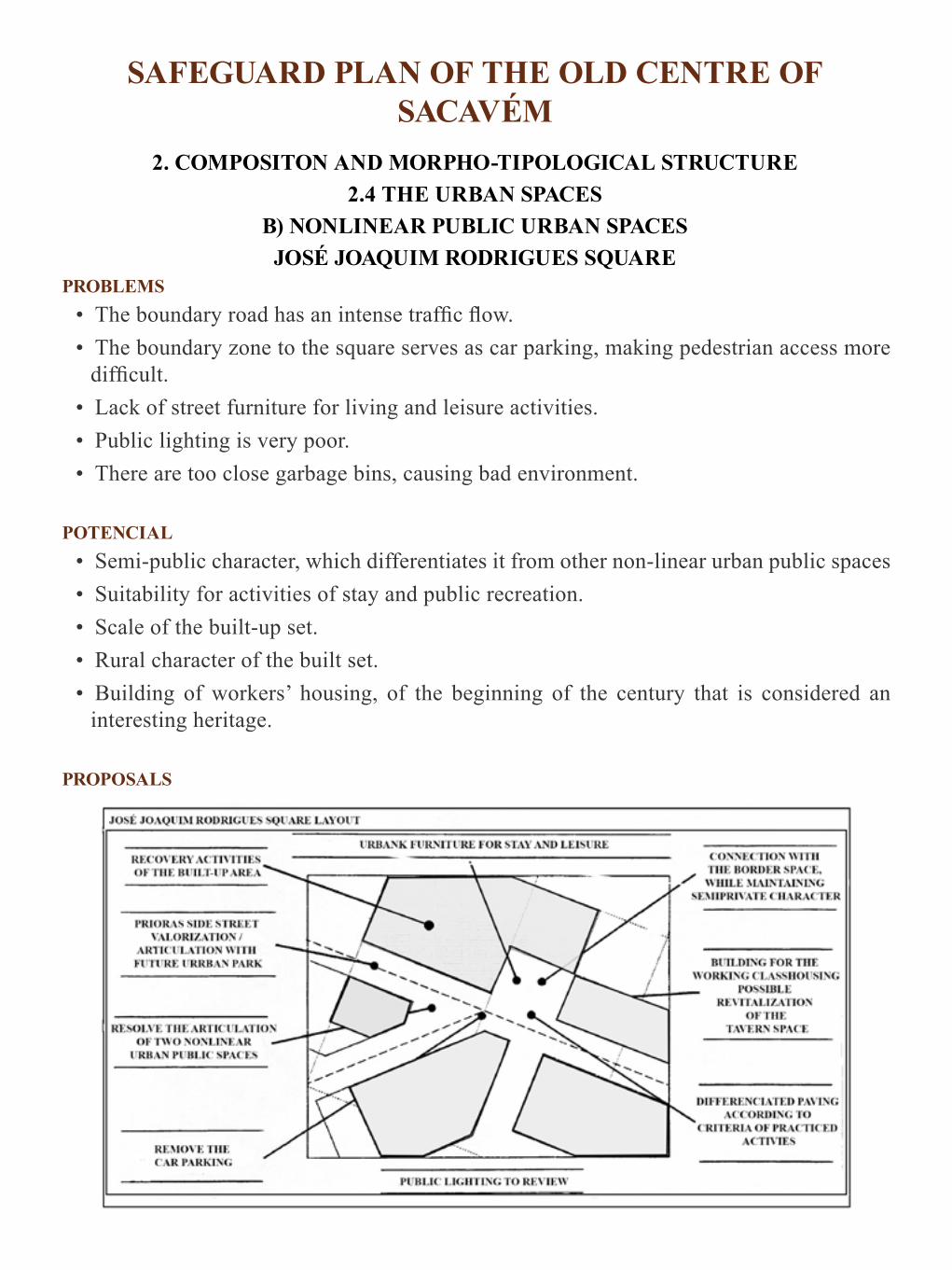
SAFEGUARD PLAN OF THE OLD CENTRE OF SACAVÉM
2. COMPOSITON AND MORPHO-TIPOLOGICAL STRUCTURE2.4 THE URBAN SPACES
B) NONLINEAR PUBLIC URBAN SPACESJOSÉ JOAQUIM RODRIGUES SQUARE
PROBLEMS• The boundary road has an intense traffic flow.• The boundary zone to the square serves as car parking, making pedestrian access more
difficult.• Lack of street furniture for living and leisure activities.• Public lighting is very poor. • There are too close garbage bins, causing bad environment.
POTENCIAL• Semi-public character, which differentiates it from other non-linear urban public spaces• Suitability for activities of stay and public recreation.• Scale of the built-up set.• Rural character of the built set.• Building of workers’ housing, of the beginning of the century that is considered an
interesting heritage.
PROPOSALS

• Inert activities of stay and recreation by: arrangements of urban space and equipment: trees/shade
• Improve the connection with the front urban space after organizing the traffic flow, keeping the semi-private character, but not the existing wall.
• Reinforcing the importance of the Travessa das Prioras by articulating with this area.. • Buildings:
– Keep the residential function; – Keep the existing economic activities; – Consider new space usage of tavern - possible disco; – Keep the volumetry of the buildings; – Restore the buildings

SAFEGUARD PLAN OF THE OLD CENTRE OF SACAVÉM
2. COMPOSITION AND MORPHO-TIPOLOGICAL STRUCTURE 2.4 THE URBAN SPACES
B) NONLINEAR PUBLIC URBAN SPACES JOSÉ JOAQUIM RODRIGUES SQUARE

SAFEGUARD PLAN OF THE OLD CENTRE OF SACAVÉM
2. COMPOSITION AND MORPHO-TIPOLOGICAL STRUCTURE 2.4 THE URBAN SPACES
C) NONLINEAR PRIVATE URBAN SPACES
ANALYSIS • There are 3 types of outer private spaces related to the type of set of buildings:
– AIR SHAFT - tight, enclosed spaces, located within blocks of small size – ASSOCIATED BACKYARDS - located at the rear of the buildings that make up
the blocks in band or/and within average size blocks. – ASSOCIATED BACKYARDS OF GREAT DIMENSION – located in buildings
in band (old farms). • It should be noted the existence of an Arab tank in an air shaft at the back of Nª. Sª. da
Saúde Church.
PROBLEMS • Problems have been detected corresponding to the three different types found:
– AIR SHAFT - health problems. – ASSOCIATED Backyards - tendency to its occupation with buildings. Over
1 2 3 COLECTIVE PRIVATE SPACES TO ORGANIZE A AIR SHAFT
ARCHEOLOGICAL STRUCTURES TO INVESTIGATE B ASSOCIATED BACKYARDS
BLOCKS TO COMPLETE C ASSOCIATED BACKYARDS OF GREAT DIMENSION
GREEN STRUCTURES TO CREATE

occupation of its area and subsequent health problems. – ASSOCIATED BACKYARDS OF LARGE DIMENSION- in some situations
there was its occupation following recent interventions in the urban centre.• Lack of cadastral survey.
POTENTIAL• The existence of large backyards and its connection to unbuilt open spaces, former
agricultural lands belonging to farms.• Existence of backyards with dimension that makes them capable of being transformed
into private collective space.
PROPOSALS • Survey of the occupation of backyards. • Study of the archeological structures in the area of the medieval tower and its surrounding
area. • Study/assessment of the need to free private outdoor spaces wrongly occupied with
storage rooms, lofts, etc. ..• Study of outer spaces, which can be made collective private ones. • Study of the reuse of large backyards to complete not built fronts and to close blocks. • Study of the playground front of the Preparatory School. • Prepare a cadastral letter and
create mechanisms for its permanent updating.

SAFEGUARD PLAN OF THE OLD CENTRE OF SACAVÉM
2. COMPOSITION AND MORPHO-TYPOLOGICAL STRUCTURE 2.4 THE URBAN SPACES
SYNTHESIS
CONCLUSION • The Area is well irrigated with linear public spaces that we have classified in 3 types:
streets, streets of confrontation and side streets. Generally they reveal problems of conflict of circulations, have little aptitude for car traffic and implementation of green structures, due to the size of their profiles
• The Area has good coverage and variety of nonlinear public urban spaces, hierarchical and that present 3 typologies: squares, significant enlargements of the streets and small squares, with good potential for the installation of economic and living activities, urban leisure and pleasure.
HERARCHY OF NON LINEAR URBAN PUBLIC SPACES 1º
2º
3º
PEDESTRIAN CIRCULATION
CAR TRAFFIC
OUTER COLLECTIVE SPACES
• Private outdoor spaces also exist in 3 types: the air shaft and associated small and medium size backyards. They have problems of inadequate physical occupation, but may allow their conversion into collective spaces for private or semi-public use.
PROPOSALS• Maintain the general character of urban spaces as well as their hierarchy.• Strengthen and qualify the existing uses as well as introducing new ones.• Resolving incompatibilities of uses (stay and pedestrians circulation).• Qualify urban spaces by paving them, introduction of street furniture, rehabilitation
or renovation of façades, street lighting renewal, redevelopment and upgrading of advertising.

COMPOSITION AND MORPHO-TYPOLOGICAL STRUCTURE LISBOA (Benfica)
Non-urbanized areasAreas in process of urbanization
Urbanization ModelRoutesBuildingsHill
Northern and central fringes
Station centre
Multiple nonlinear spaces resulting of the urbanization model

The Built-up Area
The built-up area is presented to the reader of the urban image through the exposed façades, which form the defining “walls” of the urban space that was analyzed in the
previous heading.
The façades are, from this point-of-view, integral part of the do urban space considered as architectural multidimensional space and not only, as the physical planning considered it, a space in two dimensions, organizing circulation and implementation of the built-up area or what is left of it, in order to, at best, be “landscaped”.When studying the built up area, in particular, in the reading of the urban image, we are looking for, based on observation of the façades, detecting the general characteristics of its composition and conservation conditions, to point out the problems and potentials that will

enable characterizing the general needs of rehabilitation intervention in the build-up area.The possibility to perform this analysis through the urban reading presupposes that whoever performs it previously possesses the knowledge needed to recognize, through the observation of the façades and with a reduced margin of error, the general construction and typological characteristics of the buildings.It consequently requires deep knowledge of architectural and construction history, because each period proposes different constructive, organizational and aesthetic expression, both for the current architecture, and for special programs and reveals them in the expression of the façades, the resolution of accesses, in the ways of grouping and layout of buildings as well as in its volumetry.The image reading of the built up area, itself as the subject of analysis and intervention, takes place in such a way as to allow identifying the characteristics of the area in relation to:
• Periods and types of buildings, state of preservation and general volumetry.• Current and exceptional building typologies, ways of grouping them and the aggregation
of housing buildings.• Historical and artistic patrimony.
The indicated information is collected in such a way as to enable: • Detecting and delimiting degraded areas and different apparent degrees of degradation.• Obtaining information regarding the typological variety of the present buildings in the
Area and their spatial distribution, in order to define characteristic areas according to the types of buildings that make them.
• Identifying the typologies of the present buildings in order to interpret how the built up area contributes to the definition of the usage and urban character and be the guide for the choice of buildings that represent those varieties in order to proceed to surveying the characteristics of its spatial and construction organization.
This information is important to clarify the usage capacity they offer, taking into account the present demands of the ways of living and the constructive problems that it will be necessary to face towards its rehabilitation and preservation, without performing an exhaustive survey of the built up area, a time consuming, costly operation and of little use, in this phase of the work which is identification and general location of problems, types of solutions and strategies for action, for general discussion and interest groups and for political decision. Throughout the work and, as intervention options are taken and the consequent establishment of means of study and action, the necessary surveys to obtain accurate and detailed information of the building will be defined and made and which allows proceeding to the projects’ design, reinventing solutions or reconstituting the primitive fabric.
• Getting elements for defining the overall costs and strategy for the rehabilitation of the built up area, according to its preservation condition, historical, artistic and cultural importance, the means available and the prospect of rehabilitation that will be adopted. This should be clearly explained and justified, indicating the options regarding the

importance given to the requirements of restoration or renovation, full or partial, of the building. The perspective to be adopted on the degree and criteria for conservation of the built up area should arise as a result of a reasoned debate, which has not been done and that would clarify to what extent and why the existing image should be kept, or reinterpret it and give it the expression of the present, linking new and old, or create a new image for the existing fabric.

General Characterization of the Buildings
The information regarding the built up area is collected in such a way as to distinguish and bound areas, wholly or mainly composed of buildings of the same period, or that
have a similar mixture of buildings from various construction periods, which means that they were being built and/or reconstructed over the same periods, as well as the areas, according to their degree of degradation/conservation and the dominant volumetries.
The identification, into areas, of significant sets of buildings’ “mixtures” according to the construction periods, or the built up sets that were built in the same period and, sometimes corresponding to a single project, is a valuable auxiliary to support the indication, into areas, of the present building typologies and of the predictable state of preservation/degradation of the construction. The volumetry of the built up area is also described, in general terms, by distinguishing the volumetric characteristics of the parts of the area, i.e., indicating the dominance of the number of floors that differentiates them from each other, emphasizing their homogeneity in this aspect or pointing out areas that are characterized by diversity of volumetry of the buildings that compose them.The period of construction, volumetry and state of preservation are characteristics that relate themselves and allow defining distinct and homogeneous parts of the Area, from a multitude of other aspects which lead to the identification of the problems that affect them and of the applicable solutions. It is, therefore, an analysis of the utmost importance to interpret the

composition and morpho-typological structure of the Area, define and frame the necessary surveys and studies to understand the present buildings in detail, define the requirements of their rehabilitation and their usage possibilities, when related to the active structure.

SAFEGUARD PLAN OF THE OLD CENTRE OF SACAVÉM
2. COMPOSITION AND MORPHO-TYPOLOGICAL STRUCTURE 2.5 THE BUILT-UP AREA
A) CONSTRUCTION PERIODS

ANALYSIS• The Old Centre has its origin in the XVI century. • In the first period considered: XVI-XVII and XVII-XVIII centuries and that mainly
focuses on the XVII century and on a building tradition that lasts throughout the 1st half of the XVIII century, 5 de Outubro Square, through buildings scattered around that structure it, and Direita Street, through remaining scattered buildings, can distinguish themselves. There are also buildings of this period on the edge of the Centre. There are in Direita Street (West, closer to Lisbon) buildings built by the aristocracy: the Farms and Direita Street (East, near the Square) and other buildings, simpler. The buildings and oldest traces (Torre and other medieval remains) are located in the Square and to the East of it, allowing us to understand the growth of Sacavém, from the Square towards Direita Street, in an East/West axis.
• In the XVIII century (2nd half) and XIX century (1st half), in Direita Street (West), the Farms still go on being built (buildings belonging to the aristocracy) and other houses are built or rebuilt (East). The Square is better defined with the building and, most likely, with the rebuilding of almost all the West block, keeping the same previous lots. The buildings on the edge of the Centre increase (Republican School Centre, Ricardo Antonio Street, Market block). In the nineteenth century (2nd half) Direita Street is occasionally built probably on other buildings and keeping, almost always, the early lots. Isolated buildings are built around the Centre, some of them of square layout. The Church in 5 de Outubro Square emerges as a rebuilding of an earlier chapel.
• In the XIX century (late) and XX century (early) the three large blocks of workers’ housing are built. The 5 de Outubro Square changes remarkably with the construction of the biggest block. A small building separates the 5 de Outubro Square from the Pedro José Gomes Jr. Square. Also of this period, there are less meaningful constructions in Direita Street, unless in the block where the Planning Office is installed (which could have been cut by a side street or small square). There are other buildings in blocks situated on the edge of the Centre.
• In the XX century (twenties and particularly thirties) little is built on Direita Street and nothing is built on the Square. The block east of the square suffers a deep transformation (the block tower and big V shape block) and the Terreirinho Square.
• In the XX century (forties/fifties) and, basically, in the sixties/seventies large buildings are built retreated in relation with the alignment of the street as well as on the west side of the Almirante Reis side street. Continuous buildings in Terreirinho Square deprive it from its characteristics. Almost the entire block of GNR is built up (forties/fifties) as well as buildings scattered throughout the Centre: example, the Council/Market and the building of the household appliances.
CONCLUSIONS• Regarding the analysis of the impact of construction periods of buildings in the urban
fabric we found that:
– The Area is characterized, from this point of view, by the diversity of periods in the construction of buildings;
– The incidence of the various periods of construction presents a fine structure given that they blend into the fabric, although the presence of buildings is substantial in the 2nd half of the eighteenth, nineteenth and twentieth centuries;
– The Area has undergone interventions over time thus showing the potential and dynamics of a living centre.
POTENCIAL• The diversity of buildings of different construction periods. • Cultural value of the built up area.
PROBLEMS• Diversity of construction systems which will bring problems to the rehabilitation.
PROPOSAL • Keep the existing diversity• Keep, if possible, the original construction technic of each building.

SAFEGUARD PLAN OF THE ANCIENT CENTRE OF SACAVÉM
COMPOSITON AND MORPHOTYPOLOGICAL STRUCTURE 2.5 THE BUILT UP AREA
B) STATE OF PRESERVATION
ANALYSIS • Of the 219 existing buildings, 103 (47%) are in an outer and inner state of preservation
considered REASONABLE, 70% are in BAD state and 46 (21%) are in an outer and inner state of preservation designated as GOOD.
• The built up area is composed by 525 fractions of land which include 392 (74,6%) households, 80 (15,2%) commercial establishments/shops, 14 (2,6%) restaurants/bars, 13 (2,4%) services/offices,4 (0,7%) recreational societies and 24 (4,5%) fractions of land designated as miscellaneous.
• Of the 392 households, 123 (31,4%) are in an outer and inner state of preservation considered BAD, 157 (40%) are in a REASONABLE state and 112 (28,4%) are in an outer and inner state of preservation designated as GOOD.
• The highest number of households in poor condition is located on block 048 (26) and represents 23,2% of the households. It is also on this block that the largest number of buildings in a bad state is located (18) which represent 20%. In block 035 is located the highest number of buildings in reasonable state (52 - 33,1%), as well as the highest number of buildings in good state (33 - 32%).
• Block 035 has 10 buildings in good state (22% which is a relatively high percentage. In

block 042 is located the highest number of households in good state,) which represent 41,5% of the households classified as good.
CLASSIFICATION CRITERIA OF THE STATE OF CONSERVATION OF THE BUILT UP AREA • GOOD - There are no structural defects at first sight (cracking of the structure, breakdown
of materials, and there are no structural abnormalities whatsoever or only in a small percentage, (presence of moisture, degradation and aging of materials, cracks in the plaster...)
• REASONABLE - There are no serious structural deficiencies, but they show a large percentage of non-structural abnormalities
• BAD - Presents serious deficiencies at structural level together with large non-structural abnormalities.
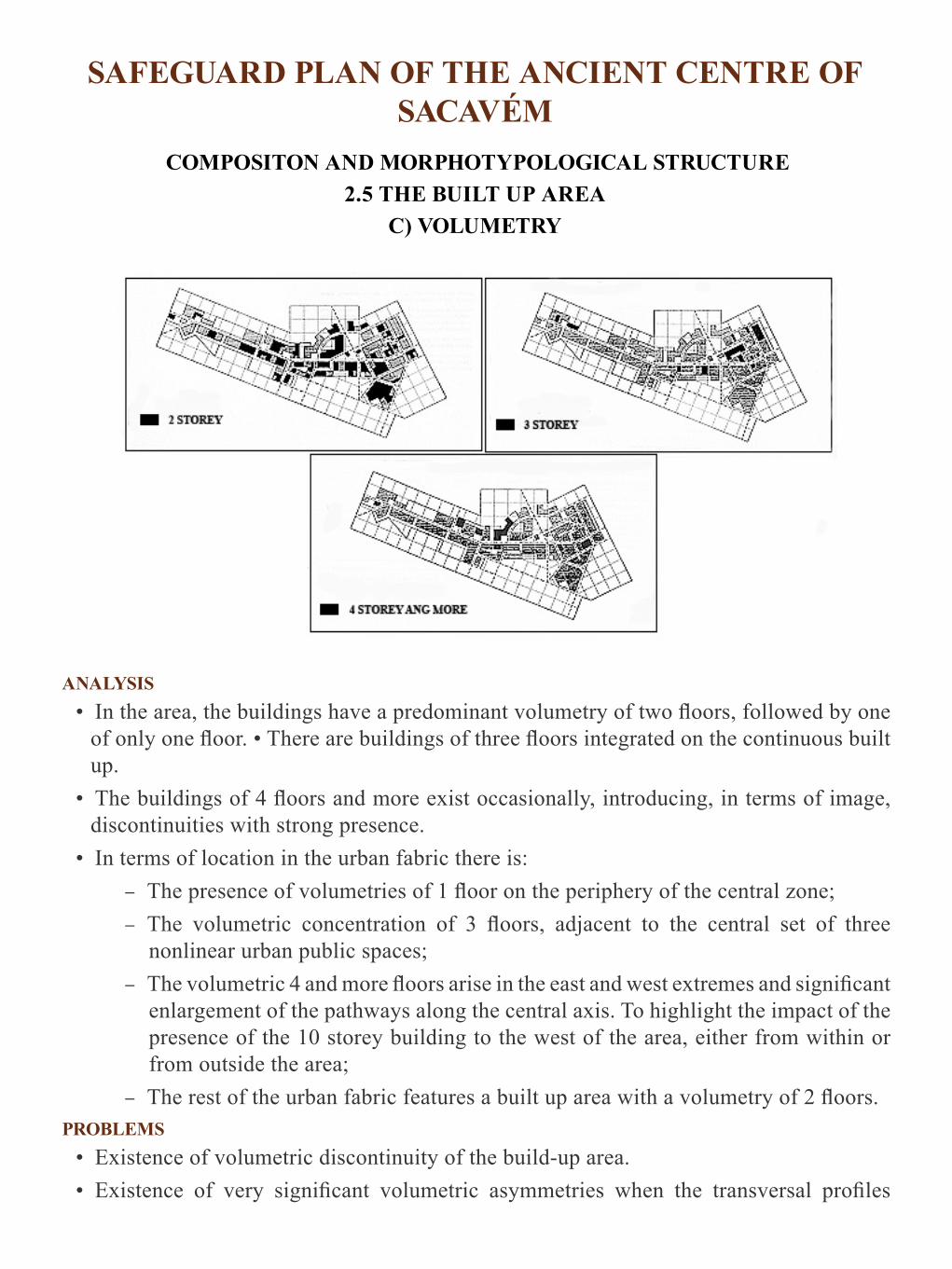
SAFEGUARD PLAN OF THE ANCIENT CENTRE OF SACAVÉM
COMPOSITON AND MORPHOTYPOLOGICAL STRUCTURE 2.5 THE BUILT UP AREA
C) VOLUMETRY
ANALYSIS• In the area, the buildings have a predominant volumetry of two floors, followed by one
of only one floor. • There are buildings of three floors integrated on the continuous built up.
• The buildings of 4 floors and more exist occasionally, introducing, in terms of image, discontinuities with strong presence.
• In terms of location in the urban fabric there is: – The presence of volumetries of 1 floor on the periphery of the central zone; – The volumetric concentration of 3 floors, adjacent to the central set of three
nonlinear urban public spaces; – The volumetric 4 and more floors arise in the east and west extremes and significant
enlargement of the pathways along the central axis. To highlight the impact of the presence of the 10 storey building to the west of the area, either from within or from outside the area;
– The rest of the urban fabric features a built up area with a volumetry of 2 floors.PROBLEMS
• Existence of volumetric discontinuity of the build-up area.• Existence of very significant volumetric asymmetries when the transversal profiles

formed by sets of buildings and public spaces are considered, especially in the case of confrontation streets.
POTENTIAL• Possibility of volumetric increase aiming to resolve discontinuities and make the set of
the built up area and urban spaces more harmonious.PROPOSALS
• Allow the increase of the floors towards harmonization and densification.• Define the places and increase rules of the built up area.

Typology of the Buildings and Households
The localized identification of the typological variety of the buildings of the Area, along with the reading that was done in the previous paragraph allows us knowing and assessing,
the buildings in general terms, and helps guiding the choice of representative buildings of this variety of types in order to proceed to the detailed survey of the characteristics of their spatial and constructive organization.
This information has, as we afore stated, the interest of clarifying the usage capacity that buildings offer over current living requirements, economic activities and the type of construction problems and image that will be necessary to face for their rehabilitation or conservation, without performing an exhaustive survey of all the buildup area.The identification and characterization, per areas, of the forms of grouping the buildings is still an important information for the characterization of the morpho typological Area and to consider how to perform physical rehabilitation.The grouping method of households in residential buildings, of easy perception by observing the accesses, alerts to the issues of sharing and management of semi-private spaces of buildings, of relationships/confrontations of neighborhood that they provide, of

the opportunities of transformation they offer, by typological junction or by division of existing households, as these present themselves excessively tight or wide, of the irrigation of urban space by the multiplication of accesses or the spacing of these, with repercussions in the dispersion or concentration of entries and exits and the consequent differentiation of access routes.

SAFEGUARD PLAN OF THE OLD CENTRE OF SACAVÉM
2. COMPOSITION AND MORPHO-TYLOLOGICAL STRUCTURE 2.5 THE BUILT-UP AREA
H) GROUP OF BUILDINGS
Small Dimension Blocks AMedium Dimension Blocks Semi-Detached Buildings
PROBLEMS• Problems have been detected corresponding to the three different typologies found:
– SMALL SIZE BLOCKS - no backyard spaces, too small dimension of some lots, causing problems related with housing conditions and inadequate occupation of the building
– MEDIUM SIZE BLOCKS - intensifying transformation of area and the small size

of some batches led to over-occupancy spaces for playgrounds and consequent health problems. There are also frequent inappropriate uses of the buildings;
– BUILDINGS IN BAND - in some situations there is the destruction of areas of terracesRelated with recent interventions - José Augusto Braamcamp Street / Almirante de Reis Street, North .
POTENCIAL• Regarding SMALL SIZE BLOCKS:
– The character they give to public space; – The possibility of being transformed into closed blocks; – The size of the block enables global intervention.
• Regarding the MEDIUM SIZE BLOCKS: – The existence of public parks that can provide interventions towards its
transformation into private open spaces for use of communities; – The size of the lots provides a good relationship with the public space
• Regarding the BUILDINGS IN BAND: • The existence of larger backyard spaces; • The connections with the open unbuilt spaces, former agricultural terrains belonging to
farms which allow closing off the urban fabric.
PROPOSALS
• 1 - North Block of 5 de Outubro Square- its reformulation is proposed with land holdings in order to build a 3-storey building (ground floor, shops, services and / or housing) and create a public space for continuity to 5 de Outubro Square. As an alternative, the reconstruction of the building of the Oliveirinha Side Street with reformulation of the

adjacent construction must be evaluated.
• 2 - West Block of 5 de Outubro Square - the opening of a side street through the interior of the backyard is proposed, in order to establish the connection with João de Deus Street and Almirante Reis Side Street.
• 3 - South Block of José Augusto Braamcamp Street, cornering with José Pedro Lourenço Street- close off of the block is proposed with formation of street fronts and redesign of its interior space.
• 4 - Corner Block of the Streets José Augusto Braamcamp and Trigueiros Martel - replotting and opening of a passage to allow connection with the small square at the rear.

SAFEGUARD PLAN OF THE OLD CENTRE OF SACAVÉM
2. COMPOSITION AND MORPHOTYPOLOGICAL STRUCTURE 2.5 THE BUILT-UP AREA
G ) HOUSEHOLD GROUPING
• The traditional system of grouping of households in the Old Centre of Sacavém is characterized by its rural character, detached buildings, sometimes houses with small walled yard, single-story or two-story or with a store and urban primitive character wooden floor: aligned along the streets, sketching blocks in band (1). Each building represents one or two households (one per floor). It is a popular architecture of building tradition previous to the earthquake.
• Buildings of petit bourgeois nature (urban). Most of them, also detached. On the ground floor is situated the store for commerce and housing is on the upper floors. They are mostly from the 2nd half century of the XIX century and early XX century. Each building of this type corresponds to one household. Examples: the building of the grocery store (Direita Street) and the building of the Planning Office (2).
• Buildings (blocks) of the working class housing with gallery or yard in the rear, allowing access to the households: small housing modules, built to group large numbers of families.
They are contemporary to many workers’ villages existing in Sacavém, but outside the Old Centre. There is also the working class housing building in band, whose access to the tight modules is done by stairs (3 in the block) with households on either side (left and right) (3). They are also buildings from the late XIX century - beginning of the XX century.
• The housing building - century XIX (2nd half) with several floors, staircase dividing the households into left and right. Each floor has two households.
• In the 30s, the century XX, the distribution of 4 households per floor is newly introduced (egg “modern” building of Direita Street (5) until the income apartment buildings of the 6Os / 70s with 5 or more floors with multiple households per floor (6).
• Farms, small palaces and buildings with architectural quality, built by a family and their staff (currently divided into several households). As an example: The Braancamp Palace, the farm “Quinta do Alexandre,” the block “Quarteirão do Sr. Matos”, the Vila-Clara Private School building or the Prioras’ assembly.
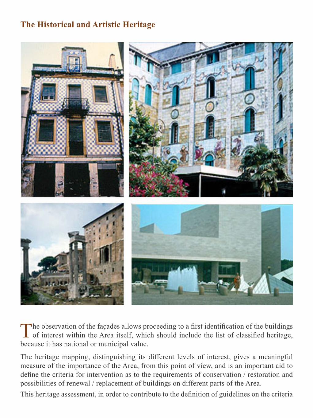
The Historical and Artistic Heritage
The observation of the façades allows proceeding to a first identification of the buildings of interest within the Area itself, which should include the list of classified heritage,
because it has national or municipal value.
The heritage mapping, distinguishing its different levels of interest, gives a meaningful measure of the importance of the Area, from this point of view, and is an important aid to define the criteria for intervention as to the requirements of conservation / restoration and possibilities of renewal / replacement of buildings on different parts of the Area.This heritage assessment, in order to contribute to the definition of guidelines on the criteria

for rehabilitation of different parts of the Area, should cover buildings, elements and details of the buildings and even the blocks, places, enclosed public spaces, plant species, green areas, and street furniture. The study and assessment of the area from the point of view of history, art and culture, which must be developed from the beginning of the work, should be deepened as the intervention decisions and to detail the information necessary to carry out their current rehabilitation and urban heritage management. The extended discussion on value of the heritage area will set the perspective on preservation or renovation and decision about its use.

Composition and Active Structure
The reading of the activities of the Area is spatialized in order to allow realizing how these appropriate the space, which active structure they define in it, what kinds of activities
are present and how they blend together or specialize, depending on the places.
It is also important to point out the type of functional units present (small, medium or large units) and check:
• If they take the ground floor, extend to the first floors or to all the buildings. • Their target type of clients. • The area of influence they have.• The antiquity or modernity of the operating system they reveal.
The active structure should include not only economic activities, but all activities of daily life, including the housing, those who gather in the equipment (studying, taking care of the health, caring for the elderly and children, cultural activities) and those that develop within the public space, either circulating or staying.The simultaneous presence of all the activities allows defining:
• The areas or axes of animation and tranquility or disinterest in the urban space.

• Assess the good or faulty fabric irrigation; • The excessive pressure in relation to spatial characteristics or the desertification of the
existing spaces; • The mono or multi functionality of the different parts and axes of the area.
The assessment of the active structure should be made regarding the characteristics of the existing fabric, the needs of the residents, the requirements of the installed operating activities and also to the Urban Settlement to serve the general population, drawing conclusions on whether or not there is the need to proceed with the introduction, expansion or reconversion of activities, specifying the places where action is needed for proper functioning of the whole fabric, respecting their characteristics and giving the population the resolution of their everyday life in a safe environment and with urban way of life. The profound imbalances that exist in the implementation of activities are known, which cause the existence of dormitories and, at the opposite pole, areas of almost exclusively implementation of economic activities with known and serious drawbacks both local and affecting vast surrounding areas due to circulation flows, the accumulation of parking and the imbalance of use in relation with the day and the evening, the weekdays and the weekend.It was already mentioned, upon the study of the insertion of the Urban Area in the Urban Settlement, that one of the issues to consider regards the predictions or decisions relating to the implementation of activities at the scale of the Urban Settlement to know the changes in the study Area will tend to suffer through them.When assessing the active structure of the Area it is essential to take into account and discuss the impact resulting from the referred decisions, that may introduce profound changes in the composition and structure, not only of the existing activities but, and as a consequence, of the different urban characteristics, in general.In order to perform quality control of the space and ways of living, it is essential to master the location of activities guiding them to places where they not only have good working conditions as they will contribute to enhancing the urban efficiency and the environment. The establishment of clear criteria for the location of activities and the creation of conditions to make them be respected is a basic condition of balance and urban quality and one of the factors that define the ways of living and their organization in the everyday urban space/ time.Controlling the location of activities is hampered by differences in land value that causes, due to the advantages of operation and image offered by its concentration, lack of planning detail that covers the territory and contains sufficiently detailed information on land use and includes the mechanisms for their discussion and ongoing assessment allowing, including in this way, application flexibility without prejudice to the firmness of the objectives of urban quality intended to achieve.This discussion and evaluation would simultaneously feed the successively awareness / problem solving related to the ways of living and its dependence on the orientation of economic development and operation of power structures linked to it.

To know, interpret, assess, and proceed to the extended discussion of the composition and location structure of the of activities in the territory at local level is an important contribution to clarifying and being able to solve a key issue of the urban life quality.The existence of a soil policy that contradicts the harmful effects of the market operation, supported by a detailed planning and effective marketing; the creation of incentives, penalties and effective surveillance; the development of reasoning that elucidates the advantages of proposed locations for the activities, makes public opinion aware and guides it in order that it discusses and monitors the distribution of land uses in a favorable manner to the harmonious urban functions are measures that help regulating this essential issue.The organization of local traders and owners to monitor their difficulties and transformation demands, the search for viable solutions in terms of usages and that are, simultaneously, viable and economically profitable, can contribute positively to maintaining the balance of usages and promote local development.In order to proceed to the reading and interpretation of the active structure, the following activity groups were defined:
• Housing, equipment, public administration and economic activities, standing out among these commerce , services and industry;
• Traffic, transports, parking, loading and unloading and pedestrian circulation; • Stay, leisure, socializing, culture, exchange and expression of marginality in the urban
space.The observation of activities must take place, day and night, weekdays and weekends as there are, depending on these periods, significant changes in their functioning, with important implications in the use of urban space and buildings. The summary of the information obtained shows the formation and active structure of the Area. Its interpretation and evaluation can detect the problems and potential of existing urban usages, develop proposals for intervention and initiate the development of regulatory strategies and negotiation of space usages. These strategies have to take the needs of the resident population, location of the activities at the Urban Settlement level, and the operation of the activities.The participation of the social agents, in general and per interest groups, in the organization of urban activities, ownership and rehabilitation of spaces is, as we have stated, a major factor of study strategies and action, in this domain. Although the installation or disappearance of economic activities does not depend on public responsibilities, it is essential to consider monitoring and support to urban activities as a local planning task.

Housing, Equipment, Public Administration and Economic Activities
The spatial distribution of activities is done by distinguishing them per areas, axes or other settings that reflect their “storage” in the territory. Since the activities are mixed
differently in space, the details of their “zoning” refer to the exclusive or dominant presence of the activities in analysis and their concentration or dispersal in the marked areas/axes.

We therefore have, with respect to housing, exclusively residential areas, of housing, and other activities with no housing. In what regards to equipment, and in the perspective of highlighting the features of interest to form a concrete and operational idea of the Area, we were brought to point out, in the case studies conducted for testing the method, the equipment per types and according to their inclusion in the fabric or located within large lots, in a dispersed or continuous form, as well as naming the equipment whose coverage markedly exceeded the scope of the Area.As for economic activities, the indication of their spatial distribution should distinguish trade, services and industry, signalling specific activities deemed of interest to highlight (egg, a hypermarket, a major shopping centre, ...) and the indication on the fact that they are concentrated or dispersed in the marked areas.Regarding public administration, the facilities according to their belonging to central or local services will stand out .The synthesis of this information corresponds to a map where the presence and the distribution of this set of activities within the Area is marked, which allows forming an idea about the characteristics of the Area, regarding:
• Possible shortages or excesses of activities. • Mono or poly-functionality. • Degree and method of irrigation of the fabric depending on the activities. • Status of spots and axes of activities’ concentration. • Continuities and discontinuities that are established in relation to the surroundings.
The assessment done allows identifying the problems, the potential and defining the locations and activities whose study is a priority for the deepening of the information gathered, and that would matter triggering immediately, given the importance of the usages in the definition and quality of the urban environment, its complexity and the inadequacy of the method of image reading for getting information beyond a first idea about the type of activities present and how they appropriate the territory.

SAFEGUARD PLAN OF THE OLD CENTRE OF SACAVÉM
3. COMPOSITION AND ACTIVE STRUCTURE 3.1 HOUSING, EQUIPMENT, ECONOMIC ACTIVITIES
A) HOUSING
PROBLEMS • One may conclude that it is possible to reside in the Area with few living conditions due
to the conservation state of the buildings and dwellings, the size of the households and the lack of basic equipment.
• To reside in this area also has problems of environmental quality due to the levels of pollution caused by the industries established in the surrounding area.
• The buildings and the households are, in general, in reasonable condition, although with an already strong presence of degradation. There are a significant number of vacant homes (25).
PROPOSALS • Keep the T1 and T2 typologies to secure and attract young people as well as not to
provide the expulsion of the elderly population.•• Introduce T3 and T4 typologies through expansions of the built up area and addition of
small typologies in order to provide, both the permanence of already installed families, and to secure others that one wants to attract.
• Provide the households of good living conditions.• Maintain the residential function throughout the whole Area and exclusively reserve for
this activity, and in a first stage, the area of the organic fabric.
INTERPRETING DIAGRAMS GREATER INTENSITY OF THE HOUSING ACTIVITY PROPOSAL OF RESIDENTIAL ACTIVITY LESSER INTENSITY OF THE HOUSING ACTIVITY

SAFEGUARD PLAN OF THE OLD CENTRE OF SACAVÉM
3 COMPOSITION AND ACTIVE STRUCTURE 3.1 HOUSING, EQUIPMENT, ECONOMIC ACTIVITIES
E) SYNTHESIS
SYNTHESIS• The dwelling function is distributed throughout the urban fabric of the Area, focusing
on its periphery with few living conditions in general.• The existing equipment is local, predominating recreational and sporting societies
whose structures are under-used. It is in the Area that the Parish and the GNR have its headquarters.
• The economic activities focus on the main axes of the Area, are diverse and have a strong presence. They serve the whole settlement and surrounding areas.
PROPOSALS• Maintain the residential function with the existing typologies (T1 and T2) and introduce
typologies T3 and T4, providing all households with good living conditions.• Introduce strong central nature equipment, in particular those of cultural nature with day
and night operation.• Revitalize the existing equipment.
BUILDINGS TO RECONVERT INTO EQUIPMENT
COLLECTIVE EQUIPMENT TO REVITALIZE COMMERCIAL FRONTS

• Maintain and increase the attractiveness of the Area by increasing, diversifying and qualifying economic activities, both in service, and in space and preserving traditional trade, if possible.
• Create the expansion of economic activities of tentacle-like form throughout the urban agglomeration.
• Maintain the location of the Parish Council, assessing its expansion, and find an alternative location for the GNR Station.

Traffic, Transports, Parking, Loading and Unloading, Pedestrian Circulation
The reading of these activities is guided by already exposed concerns when describing, the characterization of the composition and active structure, in general, and it pursues
identical objectives.
Regarding the circulation places, the spatial location is done by standing out:• The traffic directions for public and private transport.• The careers and terminals of the existing public transport.• Points and axes of higher traffic intensity and conflict relating to the car circulation and
of the latter with the pedestrian.• The spatial solutions to perform the loading and unloading, the places where these are
prohibited and the areas and / or axes where there are no problems.• The parking by indicating, per areas, the solutions and general anomalies found, as
well as other issues that will be observed through the reading, and which are deemed of relevant importance to address the activities referred to under this heading.
A summarizing letter prepares the identification of problems and potential of the Area, on these activities, and the corresponding solution hypothesis.

The specialized studies that will need to be developed for better information and to structure the solutions, often exceed the territorial scope and powers of intervention in urban areas, especially if there are major changes to be made. It is, however, essential to have an analysis report on the specific needs of the Area and look for ways of their satisfaction. Traffic, transport and the infrastructures are the issues that most emphasize the need to relate scales of intervention and make compromises between social agents, acting at different levels.

SAFEGUARD PLAN OF THE OLD CENTRE OF SACAVÉM
3 COMPOSITION ANDA ACTIVE STRUCTURE 3.2 TRAFFIC ANDA PUBLIC TRANSPORTS, PARKING, LOADONGS AND
UNLOADINGS
SYNTHESIS• The whole Area has car traffic, providing that the streets profiles allow it, which generates
permanent conflicts between cars and pedestrians.• Currently no public transport circulate in the Area, what has happened until 1990/91, with
links to Moscavide and Unhos and with location of a bus stop in 1º de Maio Square. The withdrawal of this career was reflected in the decrease of pedestrian crossing circulation, which came to produce a fall in economic activities.
• The total parking 213 places focuses on all kinds of urban space with very negative consequences for all activities related to it, because it is conflicting with activities of living and urban leisure and pedestrian circulation, considering the scale of profiles of
PARKING TO CREATE DUE TO NEW REAL ESTATES UNDERGROUND PARKING CAR TRAFFIC ROUTES EXCLUSIVE PEDESTRIAN CIRCULATION
LOADINGS AND UNLOADINGS TP PUBLIC TRANSPORT

the routes and the size of the remaining public spaces.• The loading and unloading are practiced anywhere and anytime.• The pavements of the Area are, in general, in poor condition, the profiles of the streets
are narrow and sidewalks are insufficient.
PROPOSALS• Remove the traffic from the Area only keeping three roads with car traffic.• Reduce the sense and the circulation in the West zone, by creating a roundabout of local
traffic and connection to the outside in EN10 National Road 10), resulting from new connections generated by the new CRIL node.
• Remove the parking surface Area of reordering the existing bags in the surrounding, creating two underground car parks (in 5 de Outubro Square and opposite the Baroque Palace).
• Find that new real estates, to locate in the surrounding area, create parking areas to serve them.
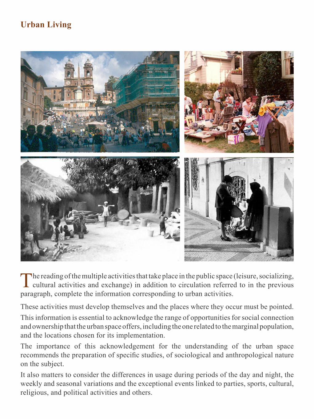
Urban Living
The reading of the multiple activities that take place in the public space (leisure, socializing, cultural activities and exchange) in addition to circulation referred to in the previous
paragraph, complete the information corresponding to urban activities.
These activities must develop themselves and the places where they occur must be pointed. This information is essential to acknowledge the range of opportunities for social connection and ownership that the urban space offers, including the one related to the marginal population, and the locations chosen for its implementation.The importance of this acknowledgement for the understanding of the urban space recommends the preparation of specific studies, of sociological and anthropological nature on the subject. It also matters to consider the differences in usage during periods of the day and night, the weekly and seasonal variations and the exceptional events linked to parties, sports, cultural, religious, and political activities and others.
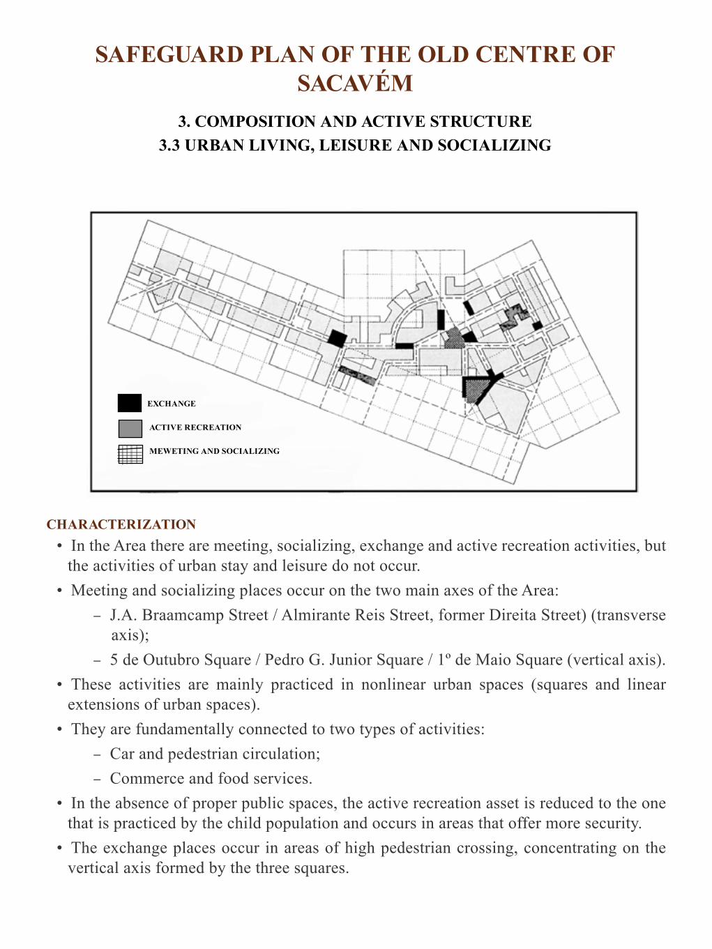
SAFEGUARD PLAN OF THE OLD CENTRE OF SACAVÉM
3. COMPOSITION AND ACTIVE STRUCTURE 3.3 URBAN LIVING, LEISURE AND SOCIALIZING
CHARACTERIZATION • In the Area there are meeting, socializing, exchange and active recreation activities, but
the activities of urban stay and leisure do not occur. • Meeting and socializing places occur on the two main axes of the Area:
– J.A. Braamcamp Street / Almirante Reis Street, former Direita Street) (transverse axis);
– 5 de Outubro Square / Pedro G. Junior Square / 1º de Maio Square (vertical axis). • These activities are mainly practiced in nonlinear urban spaces (squares and linear
extensions of urban spaces). • They are fundamentally connected to two types of activities:
– Car and pedestrian circulation; – Commerce and food services.
• In the absence of proper public spaces, the active recreation asset is reduced to the one that is practiced by the child population and occurs in areas that offer more security.
• The exchange places occur in areas of high pedestrian crossing, concentrating on the vertical axis formed by the three squares.
EXCHANGE
ACTIVE RECREATION
MEWETING AND SOCIALIZING

PROBLEMS • These activities are practiced in strongly constrained way due to:
– Lack of public spaces prepared for the development of these activities in; – Over occupation of the public space; – Traffic and parking pushing these activities to areas adjacent to the city’s street
fronts. – Lack of support street furniture.
POTENCIAL• The desire for this type of activity is very high, either because of the alternatives found
by residents or by the number of places where they occur:• The existence of a significant number of public spaces which testifies the abilities for
the development of such activities.• Good distribution of these spaces through the urban fabric of the Area.
PROPOSALS • To give public urban spaces back to the pedestrian through the implementation of the
general road plan. • Star by solving the parking problem with the creation of parking.
URBAN STAY
STAY, MEETING AND SOCIALIZING ASSOCIATED TO RESTAURATION SERVICES
MEETING, SOCIALIZING, STAY, SHOWS AND RECREATION
• Arrangement of these spaces, taking into account the prevailing activities and their availabilities.
• Creating living places and children’s recreation. • Introduction of other type of activities of cultural nature. • Incentives for the appropriation of urban space (see weekends without traffic). • Create attractiveness, covering the centre / Sacavém / region.
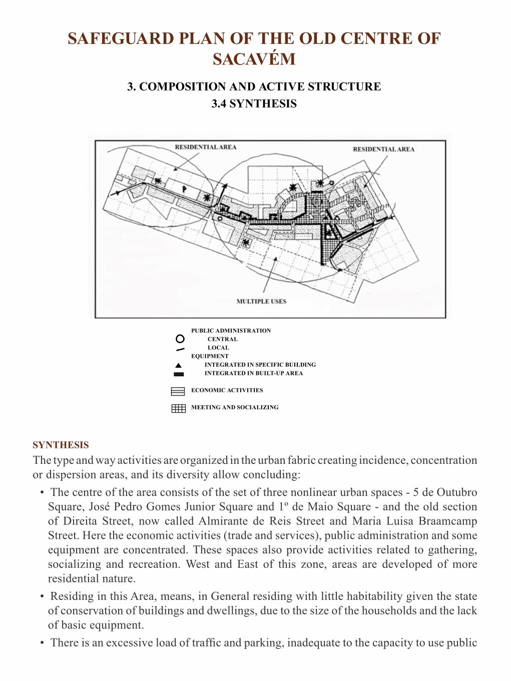
SAFEGUARD PLAN OF THE OLD CENTRE OF SACAVÉM
3. COMPOSITION AND ACTIVE STRUCTURE 3.4 SYNTHESIS
SYNTHESIS The type and way activities are organized in the urban fabric creating incidence, concentration or dispersion areas, and its diversity allow concluding:
• The centre of the area consists of the set of three nonlinear urban spaces - 5 de Outubro Square, José Pedro Gomes Junior Square and 1º de Maio Square - and the old section of Direita Street, now called Almirante de Reis Street and Maria Luisa Braamcamp Street. Here the economic activities (trade and services), public administration and some equipment are concentrated. These spaces also provide activities related to gathering, socializing and recreation. West and East of this zone, areas are developed of more residential nature.
• Residing in this Area, means, in General residing with little habitability given the state of conservation of buildings and dwellings, due to the size of the households and the lack of basic equipment.
• There is an excessive load of traffic and parking, inadequate to the capacity to use public
PUBLIC ADMINISTRATION CENTRAL LOCALEQUIPMENT INTEGRATED IN SPECIFIC BUILDING INTEGRATED IN BUILT-UP AREA
ECONOMIC ACTIVITIES
MEETING AND SOCIALIZING

spaces and that reflects into permanent pedestrian-car conflict and in the limitation of the practices related to urban living. The readiness for the practice of this type of activities is notorious which are practiced with intensity even without any support in terms of urban furniture or arrangement of public spaces. Loading and unloading are made throughout the area without any limitation of time.
• In terms of public administration there are shortages - Public Safety Police (PSP), Notary Office, etc. The creation of the future Administrative Centre, following the creation of the Municipality of Sacavém, should favour the bonds.
• In terms of transport, until recently there were two careers that crossed the area in 1º de Maio Square - links to Unhos and Moscavide - the latter having been diverted, which is considered incorrect because it induced pedestrian circuits crossing of the old town.
PROPOSALS
• Maintain the downtown character of the Area relatively to the urban agglomeration of Sacavém.
• Ensure that future expansion of the centre (the Area) is done in tentacle-like manner in order to irrigate the urban fabric of Sacavém and that the installation of economic activities is targeted.
• Assess the possibility of the future administrative centre, which will appear following the possible creation of the Municipality of Sacavém, in the former “Tableware (china)Factory”, given the location of the latter in the continuity of a structural axis of the Area and the Village and given its proximity to the future intermodal interface.
ECONOMIC ACTIVITIES
PEDESTRIAN AREAS
URBAN STAYESPLANADESCENTRES OF CULTURAL ACTIVITIESATTRACTING INTERESTS AND SITTING UP NEW ACTIVITIES

• Keep the concentration of economic activities, trade and services, without significant detriment of the residential activity: the ground floors of buildings located in the two main structural axis of the Area may be occupied with economic activities. Admittedly, even in the case of buildings that may suffer increased build ability, and only from the volumetry of three floors, the transformation of use of the first floor for installation of economic service type activities, always ensuring the residential occupation and seeking animation generating activities are set in the ground floors and avoiding night desertification.
• Encourage the qualification of economic activities. • Urgently implement the Road Remodelling Plan. • Encourage the implementation of cultural nature activities of private and public initiative. • Intervene in the most significant buildings of the Area - Republican School Centre,
Baroque Palace, Alexandre Farm, Medieval Tower - allocating them to new cultural usages and local and regional interest.
• Proceed to the arrangement of public spaces in order to provide practical activities related to urban residence.
• Maintain the existing residential activity and types of households.

Composition and Social Structure
Through the image reading of the Area it is our concern to form a spatialized knowledge of the characteristics of the installed settled population or who come from abroad to use
the Area, in terms of the dominant social groups that form it and where they are located.
The characteristics that we will try to identify are those regarding the presence of different socio-economic and age groups, also being needed to build an idea about the existence of inactive people and of high-risk and marginal groups.The more stratified and spatially segregated the population is the clearest and, therefore, less subject to errors will be the results of the image reading. Anyway, they will necessarily be defective, although they are only intended for introducing the most important aspects regarding the population in order to interpret the urban space in terms of the usage, ownership and existing sociability and pointing out the requirements for the organization of social work interventions.Rightly or wrongly interpreted, people’s characteristics and their relations with the space are implicit in reading and assessing the urban environment and are fundamental basis of that assessment. We therefore considered it necessary to make the effort of reading the human geography linked to uses perceived to even investigate the relationship between certain types of quality, animation and urban picturesque and the presence of specific social groups that usually the rehabilitation action tends to turn or expel, if not immediately, at medium-term, even if you try to avoid it.In short, the composition and social structure of the Area is based on spatialized information,
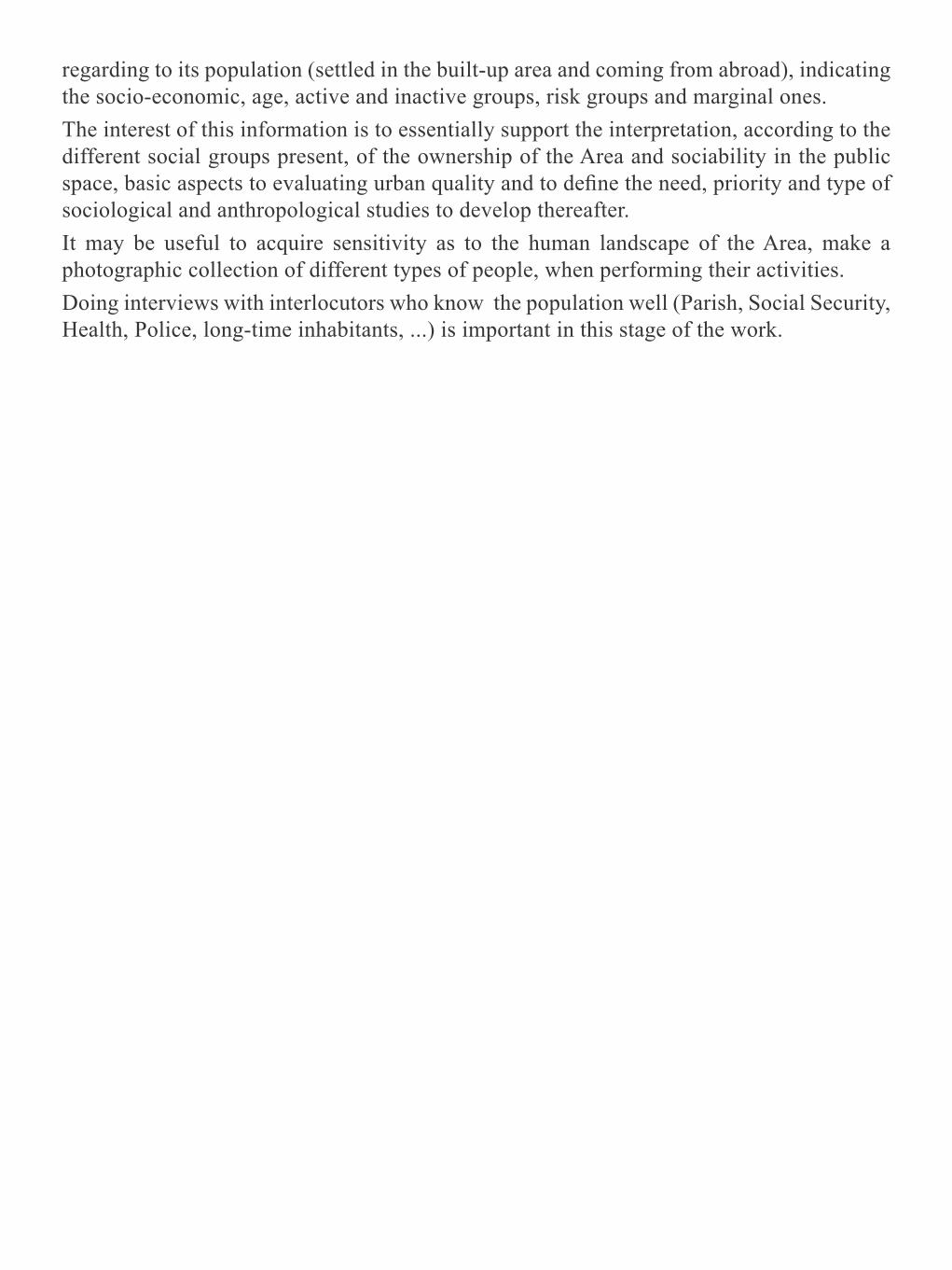
regarding to its population (settled in the built-up area and coming from abroad), indicating the socio-economic, age, active and inactive groups, risk groups and marginal ones.The interest of this information is to essentially support the interpretation, according to the different social groups present, of the ownership of the Area and sociability in the public space, basic aspects to evaluating urban quality and to define the need, priority and type of sociological and anthropological studies to develop thereafter.It may be useful to acquire sensitivity as to the human landscape of the Area, make a photographic collection of different types of people, when performing their activities. Doing interviews with interlocutors who know the population well (Parish, Social Security, Health, Police, long-time inhabitants, ...) is important in this stage of the work.

SAFEGUARD PLAN OF THE OLD CENTREOF SACAVÉM
4. COMPOSITION AND SOCIAL STRUCTURE4.2 SOCIABILITY EXPRESSION IN THE SPACE
Space Usage at Night
Daytime Appropriation of the Space by Age Groups
CHARACTERIZATION • It is in the Area that and the most important social events of the community take place.
GRATER INTENSITY OF USE
ADULTS YOUNG PEOPLE
ELDERLY

• It is in 5 de Outbro Square that parties, rallies and political meetings take place, processions leave, entertainment shows are happening, as well as cultural initiatives, etc. It is a meeting and trade point;
• It is the centre of the village and the area. • It is the set of the three nonlinear urban spaces (vertical axis) and in the insertion area
with the transverse axis (former Direita Street and M. Luisa Braamcamp Street) that the several social expressions take place, as indicated in the map.
• In terms of social events, the Area acts as a village with its parties - Alentejo Week, of the Longa, Our Lady of Health, attesting to the existence of immigrant communities across the country and the habits of meeting and socializing in the evening. People know each other; greet each other, stop and talk. They have good or bad relationship with the neighbours and express this relationship.
• There busier days, Tuesdays and Fridays and during the day, early morning and late afternoon are the periods of greater activity - arrival and departure of the population working outside.
Daytime Sociability in the Space – Activities
• The meeting places have greater or lesser number of people depending on the time of day. The use of the spaces at night is fundamentally linked to the catering services, to some communities and situations of marginality. This is mainly due to poor street lighting and to the small number of places open at night and the lack of permanent cultural activities
PROBLEMS • All expressions of sociability are practiced without any support from the viewpoint of
urban furniture and comfort.• Parking and traffic. • Existence of marginality
MEETING SOCIALIZING
EXCHANGE
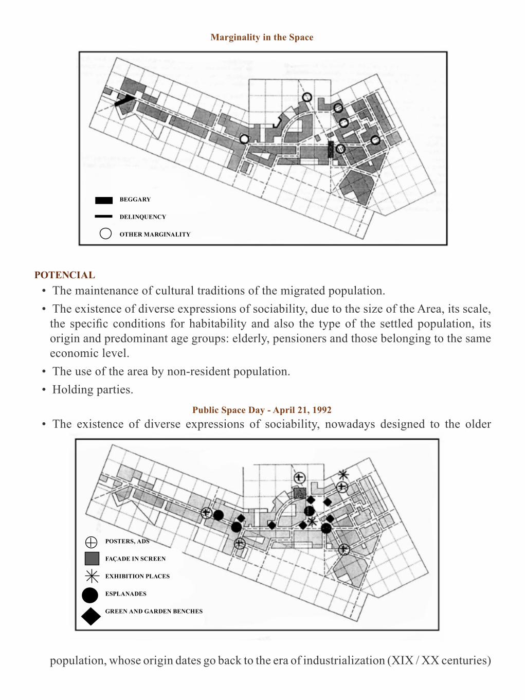
Marginality in the Space
POTENCIAL• The maintenance of cultural traditions of the migrated population. • The existence of diverse expressions of sociability, due to the size of the Area, its scale,
the specific conditions for habitability and also the type of the settled population, its origin and predominant age groups: elderly, pensioners and those belonging to the same economic level.
• The use of the area by non-resident population. • Holding parties.
Public Space Day - April 21, 1992 • The existence of diverse expressions of sociability, nowadays designed to the older
population, whose origin dates go back to the era of industrialization (XIX / XX centuries)
BEGGARY DELINQUENCY OTHER MARGINALITY
POSTERS, ADS
FAÇADE IN SCREEN
EXHIBITION PLACES
ESPLANADES
GREEN AND GARDEN BENCHES

namely cultural, sports, recreational, amusement activities with particular expression in Recreational Associations.
• Also noteworthy is the existence of a strong social solidarity expressed in a Cooperative of Credit and Consumption formed in 1900.Festivities of Our Lady of Health and Procession Route
• Locally there is a whole range of groups and services that, through their activity, contribute to the prevention and attempt to solve social problems. 8 associations (Youth Club, Youth House, Scouts ...), churches, schools, special education teachers, teachers, “Life Project” (“Projecto Vida”) , Regional Social Security Centre, Health Centre, Taipas Care Centre, Job Centre, Institute of Social Welfare, “Nest” (“Ninho”), Centre for the Study and Prevention of Drugs, Hospitals. Youth Institute, Institute of Child Support.
Festivities of Nossa Senhora da Saúde and Procession Route
PROPOSALS• Remove the traffic and arrange the public space.• Qualify initiatives and festivities.• Create attractiveness covering Sacavém and the region.• Match the expressions of sociability, namely the existence of communities with strong
traditions in order to resuming an important role in Sacavém.• Support Actions to Youth.• Support Actions to families at risk.• Promotion of leisure and culture areas.• Revitalization of social, cultural and leisure facilities.
PARTY LOCATION
PROCESSION ROUTE

Composition and Meaningful Structure
Once the Area is analyzed according to the main elements that compose it (people, activities and spaces) it is now our intention to define, interpret and evaluate its
meaningful aspects, that is to say, those that are especially recorded by the memory of users when recalling the Area and that make it distinct from the others.
Aspects that mark the characteristics, through which users describe the image and appreciate it, are meaningful:
• They allow remembering and identifying places. • Define the readability of the fabric marking points, axes and reference areas. • Symbolize collective or personal events. • They express the mental map of the area.
A reading of the kind proposed by Kevin Lynch, the collection of the maps designed for tourists and for the general population, the study of mental maps of a significant sample of users, the commentary to the survey to places that stand out as references by the observer and by the population and other methods allow identifying the significant structure of the Area, map it, assess it, identify the geographic range that it reaches (local meaning or beyond the boundaries of the Area) and draw conclusions about the need to qualify the Area, in case it

is deprived of urban meanings, or they have negative connotations.At this stage of the work, the significant structure of the Area only expresses the interpretation of maps prepared for the orientation / tourism development of the city, regarding the Area, and the marking of areas, paths or landmarks perceived as being of special interest for the observer (s). This exercise is essential to do the synthesisof the global image observed, highlighting the important references of that memory and finding their explanatory grounds. The registration of the composition and significant structure is important in deciding whether to undertake specialized studies and, if so, to provide the basis for their programming.Such structure and, broadly, the aspects related to urban meanings remain poorly understood, despite their importance for the adaptation and urban appropriation and consequent identification, esteem and pride of the people in their own territory.We consider it of utmost importance to develop this line of approach of reading the urban environment, given the potential it offers for its qualitative assessment and for the construction of intervention proposals. It is also important to note that the demand of identification and justification of urban meanings requires broad participation of the population and can, in this way and if well explored, be a key driver of interest and understanding through the community and of mobilization to assume and perform the rehabilitation of the Area.As a first guidance, we indicate the following issues to try and elucidate:
• System of readability and orientation, axes, points, routes and reference areas.• Landmarks.
• Sightseeing.• Representations and marks left on the image by the history of everyday, past and current
history.
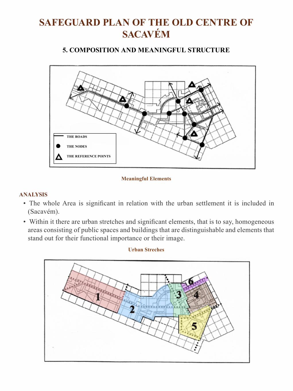
SAFEGUARD PLAN OF THE OLD CENTRE OF SACAVÉM
5. COMPOSITION AND MEANINGFUL STRUCTURE
Meaningful Elements
ANALYSIS• The whole Area is significant in relation with the urban settlement it is included in
(Sacavém). • Within it there are urban stretches and significant elements, that is to say, homogeneous
areas consisting of public spaces and buildings that are distinguishable and elements that stand out for their functional importance or their image.
Urban Streches
THE ROADS THE NODES THE REFERENCE POINTS
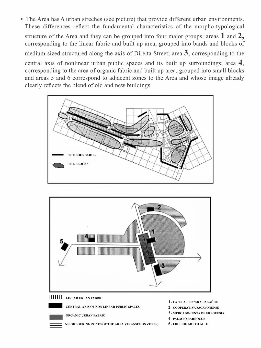
• The Area has 6 urban streches (see picture) that provide different urban environments. These differences reflect the fundamental characteristics of the morpho-typological structure of the Area and they can be grouped into four major groups: areas 1 and 2, corresponding to the linear fabric and built up area, grouped into bands and blocks of medium-sized structured along the axis of Direita Street; area 3, corresponding to the central axis of nonlinear urban public spaces and its built up surroundings; area 4, corresponding to the area of organic fabric and built up area, grouped into small blocks and areas 5 and 6 correspond to adjacent zones to the Area and whose image already clearly reflects the blend of old and new buildings.
LINEAR URBAN FABRIC
CENTRAL AXIS OF NON LINEAR PUBLIC SPACES
ORGANIC URBAN FABRIC
NEIGHBOURING ZONES OF THE AREA (TRANSITION ZONES)
1 - CAPELA DE Nº SRA DA SAÚDE
2 - COOPERATIVA SACAVONENSE
3 - MERCADO/JUNTA DE FREGUESIA
4 - PALÁCIO BARROCO5
5 - EDIFÍCIO MUITO ALTO
THE BOUNDARIES
THE BLOCKS

POTENCIAL • Existence of a rather clear and isolated image from the remaining surrounding fabric.
PROPOSALS • Maintain the diversity of urban environments; • Reinforce the fundamental E/W and N/S axes. • Reinforce the unity of all three squares.
Synthesis of the Composition and Urban Structures
Based on the analyzes conducted, the summary of the basic aspects that stood out to characterize the structure of the Area, in order to meet the objectives of the image
reading: to define, in broad terms, the current “picture” of the area, interpret it and assess it; identify and locate the problems, the potential and relevant characteristics, providing the construction of hypotheses that will lead to the rehabilitation of the Area and will guide its transformation and the development of the population settled in it.
The urban rehabilitation is an action of territorial and social change, which is not only limited to just “improve what exists.” It triggers immediate or medium term movements of population expulsion and its activities, entry of new usages and social groups, of changing the urban image, by introducing new buildings and spaces and / or valorizing those already existing.The rehabilitation of the Area can produce an emptying the transforms it in an urban museum give it a refreshed or even excessive urban life. Do not intervene leads to ongoing physical and social degradation, or in other words, the non intervention also causes transformations.The assessment of the Area and the construction of intervention hypotheses presupposes the non-deterministic response to the issues concerning the type of urban space and the ways of living that occur in it and that it will tend to be held after the interventions that are presented, still as hypotheses:
• Which population is fixed and which is floating? • Which activities occur in the built space and outer space? • What kind of society, natural and built environment, conditioning or freedom in face of
the inherited presences that form the area? • Which is the spatial / formal definition of the domains of public and private ownership? • Which are the quality requirements and how concretely do they express themselves? • What mobility does the rehabilitated space provide and through what means of circulation?
Issues that inform the different “ideas or concepts of city” and that will serve as the standard evaluator of the existing fabric and guidance for the construction of the proposed interventions depends on the investment on:
• Heterogeneity or social homogeneity; • Multi or mono functionality; • Breadth or containment of the spaces; • Privatization or the passage to public domain of outer space areas; • Conservation, creative elaboration or aggressive assertion of the expression of the
present in the urban image; • Relative importance of the private car, public transport and the pedestrian.
The “diverse city” is a concept of urban quality obtained by the presence of different urban

and successive patterns harmoniously combined in space. This concept of “good city” allows a complete rehabilitation that respects the different stretches or urban areas built in different periods, but requires the effort to create and manage a socially diverse residence offer in each of the different types of fabric to allow the settlement between urban characteristics and preferences of theses population groups who like them and want to live in them. The freedom of choice of the place of residence that existed, although with constraints, given the diversity of socio-economic opportunities that each urban area and even each building offered, is a value to retrieve or we will run up against, with regard to the large majority of the population with the imbalances between their preferences as to the type and location of the place of residence and the stretch of the city where he had to go and live, with the resulting blunders and general malaise that such mistakes cause and the consequent worsening of problems of social segregation and its set of social difficulties and spatial organization.At this stage, the building exercise of intervention hypothesis that materialize, in the study area, the different patterns of urban quality deemed appropriate is important, in order to expand the range of opportunities for the different population sections, not to multiply ghettos and to provide a naturally integrative fabric by the diversity of opportunities it offers. It is essential that the knowledge synthesis gained about the Area clearly transmit, the “idea (s) of city” that is (are) expressed therein and that the assessment is done by explaining which are the “ideas of good city” wanted to be applied in different parts of the fabric, if the option taken is to diversify them. The discussion of the intervention hypotheses to be held following the planning process of rehabilitation Area, will thus have concrete bases to take effect. The social actors involved in the rehabilitation process should be aware of the different living standards/urban image proposed as an alternative to perform the rehabilitation, or they will not consciously be able to participate in the critical evaluation of the present city, in the definition and construction of concrete options of social development and territorial qualification.

Urban Furniture, Lettering, Vegetation and Animals
The information on street furniture, the lettering and plants and animals species living in the urban space of the Area is important for the formulation of the rules to be
respected in the design and use of outer spaces, regarding these aspects and differently for the different urban stretches.
Therefore, the survey and indication of the distribution of these existing species in the Area and should be done and pointed out:
• Its characterization according the type of tasks;• The variety of design types of the first ones and characteristics of the second ones;• They way they are organized per areas or mingled in the same spaces.
These informations are important to undertake an assessment of their possible lack or excess, functional adequacy and formal quality.

The amount of advertising that invades us, its increasing aggressiveness, its inadequacy in the urban image and the generally misleading information that it conveys requires rethinking beyond the scope of rehabilitation of an area, but it would be important to know, discuss and rehearse types of responses at this level.Activities and the furniture of urban space are closely interrelated and should be studied in parallel, either to meet the identified needs, or to provide the discovery of new usages of the space. Account should be taken, with regard to furniture and lettering, to its response to the following:
• Lighting;• Stay, culture and leisure activities;• Capacity of information and guidance;• Services to the community: transport, telephone, street cleaning;• Security.
Another major issue for urban quality relates to the presence of plant and animal species, with the weight of the “green” in relation to the “built up”, with different expressions and functions that the “urban vegetation” can take and play in environmental qualification and bringing the city to nature, without undoing the mineral character that the city offers, and that is one of its characteristics.The lack of contact with the “natural” environment is increasingly felt and causes phenomena like having a second home, multiplication of tourist facilities and mass exits from the city on weekends and holidays and even the abandonment of the city by those who do not need it to solve their everyday work.The excellence of the city is threatened, and its humanization is presented as a problem of environment survival, not only the urban but also the rural, increasingly affected by the invasion of temporary urban escapees and without the “culture of the land.”

SAFEGUARD PLAN OF THE OLD CENTRE OF SACAVÉM
7. URBAN FURNITURE AND LETTERING

ANALYSIS• The existing street furniture in the area consists of:
– Street lighting columns; – Garbage containers; – Paper Bins; – Traffic signals; – Mail marks; – Protector marks.
• There are various kinds of “lettering”.• The Municipality of Loures has a specific regulation for advertising in enclosed areas
like Old Centres, yet rules should be established which are more integrated under the rules of the present Plan.
PROBLEMS• Great shortage in terms of urban furniture.• Poor street lighting - the work of strengthening the framework at the East zone of the
Area, the West part missing.• Existence of garbage containers and problems in the collection of solid waste.• Excessive advertising charge and inexistence of rules.• Tendency for the placing of awnings in disorderly manner.
PROPOSALS• Creation of a line of furniture adapted to the needs of the Old Zone. • Definition of “lettering”, type of advertising platforms and rules for the placement of
awnings. • Limited release of a tender for the street furniture and “lettering”. • Placement of suitable lamps. • Awareness campaign for traders to create incentives to replace advertising. • Creation of common advertising spaces.

Urban Character
The whole urban intervention, as we have repeatedly stated, corresponds to a transformation, physical, social, economic and environmental changes, to greater or lesser extent and
seeking: to maintain and improve what exists, because its quality is recognized or to change it because it does not comply the urban requirements. Either in one case as in the other, it is necessary to define the particular expression of the place in presence.
Each place has its own expression, recognizable and identifiable per periods, urban styles, cultural values and financial means that governed its construction expression. The climate and topography, ways of living that they serve and other multiple factors give it a specific character, accentuate this own expression.The rehabilitation intervention, whether it preserves the character of the Area or changes it,
requires identifying the characteristics that particularly define it, as they are expressed, which are the urban design solutions, which programs, which color and form dominances, which bright / dark, which spatial alignments and cuttings, which visual relationships between nearby and distant spaces between them are established.This image analysis to identify the urban character is of great importance to enable defining the type of urban solutions that adjust to what already exists and serve as a basis for the elaboration of standards of urban design, that is, of the indications that the planning should provide to designers and promoters who will interpret and implement the aforementioned proposals: the projects of buildings and outdoor spaces to “integrate” in the Area whose character one wants to preserve or those that have to be built to give to an urban fabric of poor quality, or amorphous, its own character and value.What does it mean to integrate a new proposal in an existing environment? Which characteristics have to be respected? How to act so that the new does not deviate or damage, but rather potentiates the kind of quality of the existing image? What indications can the study of the image provide so as to “grab a space” to complete it, to give it the shape / urban look that it performs as a part of that place? Where and how to demand a new project to “delete” itself in the built up set or that it takes the initiative to solve a failed or amorphous image set? What fails in an urban image?The study of the urban character of an Area, of the whole or the variety and sequence of its different parts, according to image impositions, should try to respond to such concerns. The reading of the urban image, as shown, is an attempt that has to be made, at planning level, as an essential contribution to the study and control of urban design, to give content to the city architecture, in order to be able, as Barnet, J. indicated, to “draw the city without drawing their buildings,” to interest the architecture on this scale of formal intervention lost in zoning plans, the juxtaposition of urban settlements and author buildings, whose character is controlled, most of the times, by the goal to create an image that publicly affirms and advertises this one and its customers.These questions are open. It urges studying them in order to give them content and establish appropriate procedures for the elaboration, discussion and application control standards of urban design and landscape in general. It is necessary to recreate an aesthetic culture of the environment generally internalized and save for special situations and for urban landmarks, the natural works, the claims of modernity defying consensual aesthetic, image shocks sometimes so necessary for learning new languages.To get information about the urban character, it will be necessary to try and analyse the following issues:
• Type of formal solutions regarding: – Sequences of public spaces; – Sequences of façades; – Significant details.

• Color Palette. • Human Environment. • Environment of installed and movement activities. • Sound and light environment. • Vegetation and type of landscaping.
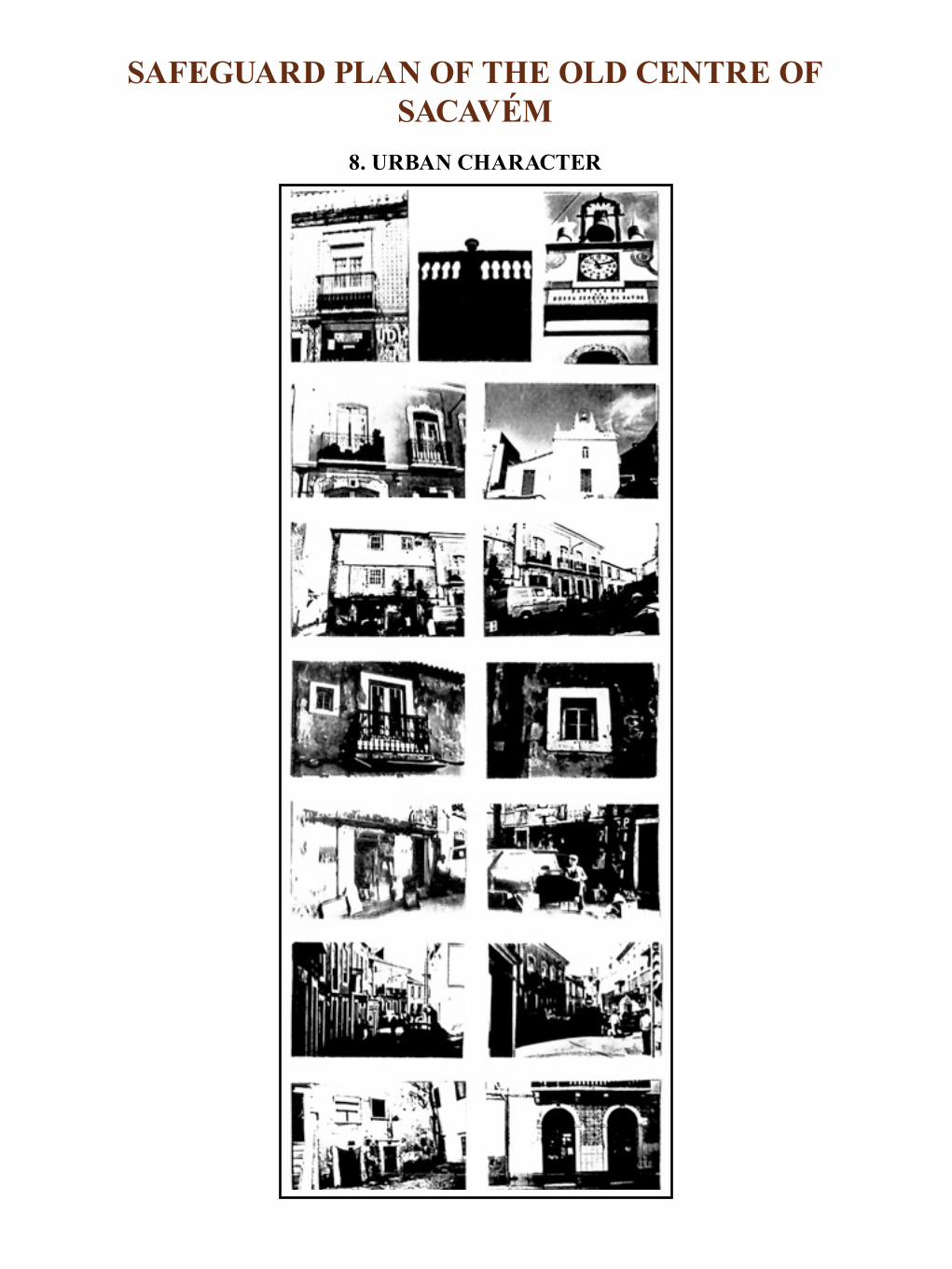
SAFEGUARD PLAN OF THE OLD CENTRE OF SACAVÉM
8. URBAN CHARACTER

ANALYSIS • The Area has a well-defined character that comes from its clear and organized urban
structure, accentuated by the fact of entering a territory that has opposite characteristics. • It is an Area where the human scale dominates, low volumetries, which from the formal
point of view, shows a dominance of flat façades with balcony doors on the 1st floor and doors and windows on the ground floor.
• It is also characterized by the diversity of colours and periods of construction of its buildings, which however, formally maintain a rural character, which means little typological diversity of façades and gives the Area an image of uniformity.
• From the point of view of activities and social aspects, there is also a matching diversity throughout the Area, giving it a homogeneous character.
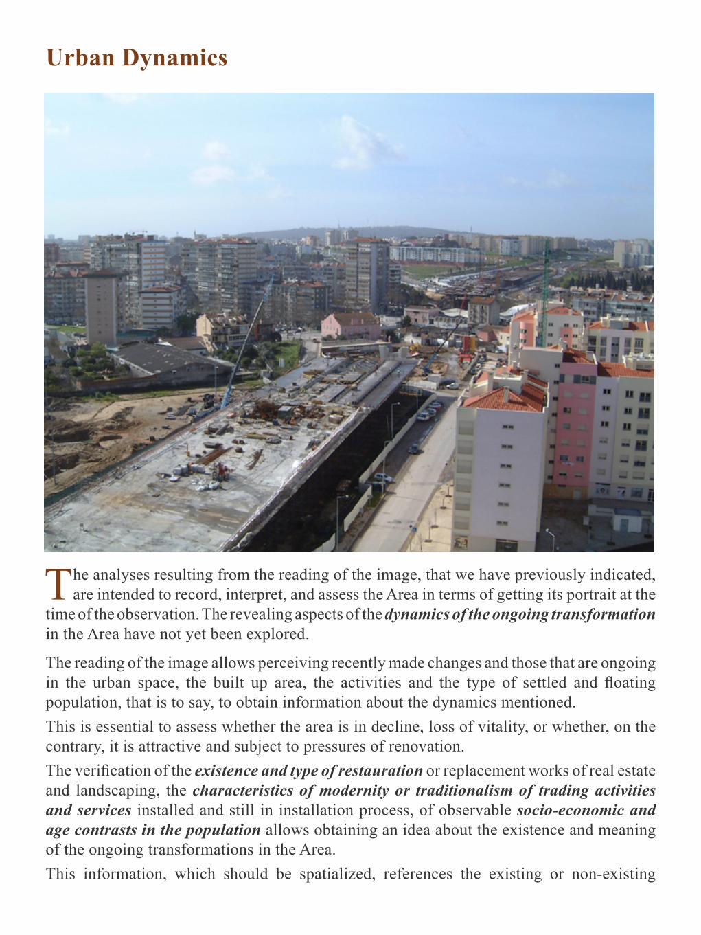
Urban Dynamics
The analyses resulting from the reading of the image, that we have previously indicated, are intended to record, interpret, and assess the Area in terms of getting its portrait at the
time of the observation. The revealing aspects of the dynamics of the ongoing transformation in the Area have not yet been explored.
The reading of the image allows perceiving recently made changes and those that are ongoing in the urban space, the built up area, the activities and the type of settled and floating population, that is to say, to obtain information about the dynamics mentioned.This is essential to assess whether the area is in decline, loss of vitality, or whether, on the contrary, it is attractive and subject to pressures of renovation.The verification of the existence and type of restauration or replacement works of real estate and landscaping, the characteristics of modernity or traditionalism of trading activities and services installed and still in installation process, of observable socio-economic and age contrasts in the population allows obtaining an idea about the existence and meaning of the ongoing transformations in the Area.This information, which should be spatialized, references the existing or non-existing

dynamic, regarding the whole Area or its parts.In this way eventual transformation trends are perceived, the development or decline of the Area is assessed, as well as the parts and axes of stagnation and development.It is essential to complement this information to the collection, with the municipal services, of existing applications for licensing of projects and works in progress, undertaken by private entities, with public responsibility and the movement regarding the installation of commercial activities, services and offices and the residents loss or increase. The information produced by the press through the advertisements regarding the purchase and sale of households and real estate (buildings), establishments trespassing, rental proposals and other information as those related to changes in employment, changes in the prices of land and other economic indicators, are an important contribution to know and assess the ongoing transformation trends . The mapping of the obtained information allows clarifying the geography of urban development trends of the Area, interpret and assess the advantages and disadvantages of such evolution and the interest of investors for the different parts of the fabric. The intervention hypothesis are thus defined in terms of the effort that will be needed to boost or hold social agents in action in the Area and to assess the medium-term impact, either of the ongoing process of change, or the rehabilitation measures to be taken in order to guide it.

SAFEGUARD PLAN OF THE OLD CENTRE OF SACAVÉM
URBAN DYNAMICS
CHARACTERIZATION • The general evolution tendency of the resident population, with regard to the dynamics
of transformation, is regression, which is explained by its aging and its non-replacement, due to poor living conditions and no transmission of leases, which implies the non-permanence of young people and eventually because they prefer searching for other places with better urban image.
• There are already faint signs of transformation and awakening of a dynamic, by the owners and investors towards rehabilitation of existing buildings:
– resident owners; – non-resident owners interested in renewal when they have sets of buildings; – investors who are buying, transforming and selling, and express interest in
continuing their activities; – investors for new buildings on the fringes of the Area (for example, Alexandre
Farm (Quinta do Alexandre) and Poças Farm (Quinta das Poças), with housing and trade and services and trade, respectively).
• The population looks for the technical support of the Planning Office to do work or to get information about future supports and about what will be the future of this area.
• In all qualification situations, we can see that:
FOLLOW UP IMPROVEMENT WORKS, ELABORATION OF PROJECTS DEALING WITH TENANTS’ COMPLAINTS, CONTACT WITH OWNERS.

– The buildings that have had improvements qualify housing conditions and public space;
– Economic activities that settle qualify its spaces, products and services, reflected in public space and inducing other activities.
• As to economic activities, and after a period of decline until 1990, this sector is the liveliest in the Area, with greater dynamic in the sense of transformation, growth and qualification.
• There are activities that have disappeared (the tailor, the old coffee) and are replaced by others, already linked to new needs and tastes (bread shop).
• There is qualification of spaces, maintaining the same type of activities. • There is the reopening of old spaces closed for long, for the setting up of new activities.
The “pressure” is very significant for the transformation of traditional uses into economic activities towards outsourcing. It is primarily, but not only, located in the principal axes of economic activity.
• This transformation dynamic to the level of the built up area will generate changes in terms of the resident and user population:
– The one that is already announced will be reflected, above all, in the user’s, since the projects are on the periphery of the Area;
– The Area is an important meeting point and a crossing zone, in particular by non-residents;
– There are some cases of residents who already manifest tendency to leave the Area if they are compensated by the owners;
• The Area is crossed by flows of Preparatory and Secondary Schools young people, by flows of collective transport users, whose stops are on National Road 10 and by the customers of economic activities installed here.
• There are also situations of residents who acquired the households where they live in;• From the analysis of the maps, we find that:
– There are areas of greater dynamism, for example, the central area formed by the axis of nonlinear public spaces and the of Direita and Maria Luisa Braamcamp Streets, and even the area around the intersection of Streets Trigueiros Martel, José Augusto Braamcamp and Prioras Side Street;
– This dynamism is linked to economic activities - improvement of spaces and trespasses, and to collectivities - maintenance and improvement works, and housing, predominantly for owners.
• The establishment of a municipal office generated expectations and dynamics in the resident population, expectations that have been fed through the provision of a public service of the urban management, monitoring of works and preparation of projects and, in collaboration with the Local Councils, organizing and following up requests for materials;

• It is necessary to take advantage and encourage this dynamic, raised through incentives to
– The rehabilitation of buildings; – The qualification of activities.

Results of the Image Reading
The knowledge and diagnostic of the Area, in terms of what exists and of the dynamics of its own transformation and the set of formulated intervention hypotheses allow preparing
a summary document that highlights alternative proposals for:
• Objectives, policies and general strategies of rehabilitation of the Area; • General hypothesis of intervention that serve them; • Rehabilitation operations that organize, in concrete actions, compliance with the
intervention hypothesis in what regards the short and medium term. It is essential to the operation of the work done, that the final product of the analysis is the definition of informed rehabilitation operations in order to:
• Enable the development of general cost estimates and implementation deadlines; • Get the bases that allow developing the programming of the respective implementation
projects; • Define financial and organizational means to make available and to capture in order to
perform them; • Identify the social agents who will be involved in operations;• Serve as a basis for public discussion.
It is still essential to make a proposal or alternative proposals for the organizational and technical structure, and of financing the support process of physical rehabilitation and dynamical development of the Area. The planning action cannot be reduced to the approval of a plan that is quickly outdated and to a current management that follows the old routines. We recall that the work of reading the image, despite leading to the definition of the rehabilitation operations, is far from completing the technical information for planning, as it corresponds to a first technical proposal that serves to cause and support the discussion between the different social agents, formal and informal, phases that are followed in the planning methodology draft and which aim at settling ideas and actions between them, as well as the establishment of consensus and commitment of fulfilment and verification of the interest, capacity and availability of accomplishment means.It is important to emphasize once again that the reading of the urban image, as we describe it, is a tool for technical preparation of the team to be able to support, from a methodological, technical and organizational point of view the planning/action process and not to replace it, offering the ultimate solution and for all problems, supposedly ready to be applied, despite the non-verification of its compliance with the wishes and possibilities of social agents or, what is more current, listing the recommendations without the worry of checking whether they are viable without presenting the solutions and operations that fulfil them.The planning would be then emptied, and would abdicate of the educational development that the continuing planning process, participated and solidified in time, implements.

The presentation of the study and the proposals should be made in non-academic manner and guided by the concern to make their content easy and quickly understandable to social agents.The lack of time that the referred agents normally have and its not necessary technical preparation require great clarity and simplicity of exposition, quick perception of what is specifically recommended, at what cost, when and through which human, technical and logistical means. The requirements for reporting and public discussion of the work done, reinforce the need for its clarity as well as the presentation of the concrete operating ways proposed and the indication of interventions that occurred may, in fact, be fulfilled in short term, because there is political will, the availability of funds was assessed and the technical and management capabilities for its realization exist.
Lisbon, March 1989

BIBLIOGRAPHY
ABRAMI, G. - Progettazione Ambientale, Roma, Dedalo, 1987. • ALEXANDER, C. - Uma Cidade não é uma Árvore, Lisboa,Arquitectura 95,1967
(22-29). • Notes on the Synthesis of Form, Cambridge, Mass. Harvard University Press, 1964. • A Pattern Language, Atenas, Ekistics 23 (139) June 1967 ; • The Environmental Pattern Language, Atenas, Ekistics 25 (150) May 1968.
ANTUNES, A: A; ROSA - Contribuição para a Definição. das Necessidades Sociais a Nivel do Quotidiano numa Área Urbana
• 1ª PARTE - Práticas Sociais Quotidianas e Apropriação Social do Espaço, Lisboa, LNEC, 1989
• 2ª PARTE - Utilização e Apropriação de Áreas Urbanas, Lisboa, LNEC, 1990 APPLEYARD, D. - The Environment as a Social Symbol: Wlthin a Theory of Environmental Action and Perception. Journal of the American Planning Association 45 (2), April, 1979.

• Towards an Urban Design Manifesto, Berkeley, Institut of Urban and Regional Development, University of Califórnia, 1981.
• Urban Design Guidelines for Management, Berkeley, Institut of Urban and Regional Development, University of California, Working Paper N° 385, April 1982.
BAILL Y, A.S. - La Perception del Espacio Urbano - conceptos, metodos de estudio y su utilization en la investigacion urbanística, Madrid, 1979. BARNET, J. - An Introdution to Urban Design, New York, Harper & Row, 1982. BERTRAND, M.J.; LlSTOWSKI,H. - Les Places dans la Ville , Paris, Dunod, 1984. BOGANOVIC, B. - Symbols in the City and the City as a Symbol, Atenas, Ekistics, 39 (232), 1975 (140-146). BROADBENT,G. - Emerging Concepts in Urban Space Design, Van Nostrand Reinh (International) Co, London, BROTCHIE, J. , NEWTON, P. , HALL, P. (editores) - The Future of Urban Form - the impact of new tecnhology, New York, Croom Helm, London & Sydney Nichols Publishing Company, 19CANIGGIA, G. , MAFFEI, G. L. - Composicione Architettonica e Tipologia Edilizia 1. Lettura deli’ Edllizia de Base, Padova, Marsilio,197 CASTEX, J., PANERAI. C. e PH. - Lecture d’une Ville: Versailles, Paris, Editions du Moniteur, 1980 CULLEN, G. -The Concise Townscape, London, Architectural Press, 1971. DUPLAY, C. e M. - Méthode lllustrée de Créatlon Architectural, Paris, Editions du Moniteur, 1982. FALCO, L. - I “Nuovi” Standard Urbanistici, Roma, Dedalo, 1987. FERREIRA, M. I. CAETANO - Contribuição da Análise Paisagística para o Planeamento da Reabilitação de Áreas Urbanas _ Estudo de Caso: Madragoa / Lapa e Benfica. Lisboa, LNEC, 1991
• 1ª PARTE - Contribuição da Análise Paisagística no Planeamento do Desenvolvimento Socio-Urbanístico de Áreas Urbanas, Lisboa,LNEC,1989
• 2ª PARTE - Índices de Qualidade Ambiental, Lisboa, LNEC, 1990 GAITI, A. - II Disegno della Cittá, Roma, Dedalo, 1987. GROTH,P. - Street Grids as Frameworks for Urban Variety, Cambridge, Harvard Architectural Review, 2, Spring 1981 ,MIT Press. JACOBS, A. , GOULD, L. - Observing and Interpreting the Urban Environment. Case Study: Naglee Park, San Jose, Berkeley, Institute of Urban and Regional Development, University of California, Working Paper N° 372, February, 1982.KRIER, R: - EI Espacio Urbano, Barcelona, Gustavo GiIi, 1981. LYNCH, K. - A Imagem da Cidade, Lisboa, Edições 70, 1982(1 ª edição Harvard, Mass. 1960).
• A Theory of Good City Form, MIT Press, 1981. • City Design and City Appearance, in Principies and Practice of Urban Planning, Goodman,

W. and Freund, E. (editores), Washington International City Manager’s Association, 1968.
• Site Planning, Cambridge, MA, MIT Press, 1980. • Managing the Sense of a Region, Cambridge MA, MIT Press, 1980. • City Design: what it is and how it might be tought, Urban Design International , VI, 2,
1980. PANERAI, P. et ai - Elementos de Analisis Urbano, Madrid, Instituto de Estudios de Administration Local, 1983. PITTALUGA, A. - Il Paesaggio nel Território, Roma, Dedalo, 1987. PITTAS, M. - Defining Urban Design, Urban Design International 1(2) 40 1980. RAPOPORT, A. ; KANTOR, R.E. - The Perception of Urban Complexity, AIP Journal, March,1970.
• Human Aspects of Urban Fm: towards a man-environment approach to urban form design, Oxford, Pergamon Press, 1977.
• The Meaning of the Bullt Environment: a no Verbal Communication Approach, Beverly Hills: Sage, 1982.
SAN FRANCISCO DEPARTMENT OF CITY PLANNING - The Urban Design Plan of San Francisco, California, 1971;
• Guiding Downtown Development, San Francisco, 1980. SANTOS, C.N.F., VOGEL, A. - Quando a Rua Vira Casa, Rio de Janeiro, Instituto Brasileiro de Administração Municipal, Centro de Pesquizas Urbanas, 1981. VALENTE PEREIRA, L. - Definição da Forma Urbana no Planeamento Físico, Lisboa, 1982 (Memória N°570).
• Urban Form Definition in Urban Planning - Sinopsis, Academia.edu, 2014• A Imagem da Cidade. O Conceito de Cidade. Leitura Análise e Diagnóstico da Imagem
Urbana. O Plano de Desenho Urbano de São Francisco, Califórnia, E.U.A., Lisboa, LNEC, 1984.
• Atelier Experimental, Internacional e Interdisciplinar para o Ordenamento duma Zona Contígua ao Centro Histórico de Évora, Lisboa, LNEC, 1986.
• Método de Apoio Técnico à Acção de Desenvolvimento Socio-Urbanístico de uma Área Urbana de Intervenção, Lisboa, LNEC, 1986.
• Reabilitar o Urbano ou como Restituir a Cidade à Estima Pública, Lisboa, LNEC, 1986. • Metodologia de Planeamento da Reabilitação de Áreas Urbanas, Lisboa, LNEC, 1991
(Memória N°769).
