fy04 program plan for the integrated ocean drilling ... · fy04 program plan for the integrated...
TRANSCRIPT

FY04 Program Plan for the IntegratedOcean Drilling Program (IODP)
November 21, 2003
Draft version to the Science Planning and Policy OversightCommittee (SPPOC)
Submitted by James A. Austin Jr., interim director, IODP

2
A. PREFACE..................................................................................................................................................3
Document Structure................................................................................................................................4
B. EXECUTIVE SUMMARY.......................................................................................................................5
1. IODP – ORGANIZATIONAL FRAMEWORK & PROGRAM PLAN..................................................................5Implementing Organizations ..................................................................................................................7IMI ..........................................................................................................................................................9Science Advisory Office........................................................................................................................10Science Advisory Structure (SAS) Office..............................................................................................11Project Management ............................................................................................................................11Project Scoping ....................................................................................................................................11Coordination of the IODP Program Plan ............................................................................................12SOCs and POCs ...................................................................................................................................12Scientific Highlights of the FY04-05 Science Program........................................................................13
2. IODP SCIENCE PLAN SUMMARY FOR FY04............................................................................................13Juan de Fuca Ridge Flank Hydrogeology (545-Full3) – Expedition 1/300.........................................13Central Arctic Paleoceanography (533-Full3) – Expedition MSP-1...................................................14N. Atlantic Neogene-Quaternary Climate (572-Full3) – Expedition 2/301 & 5/304a.........................15Atlantis Oceanic Core Complex (512-Full2) – Expedition 3/302 & 4/303..........................................15Norwegian Margin Bottom Water Expedition (543-Full2) – Expedition 5/304b.................................16
3. FY04 BUDGET OVERVIEW .....................................................................................................................19
C. FY04 IODP PROGRAM PLAN.............................................................................................................20
1. IODP ORGANIZATIONAL FRAMEWORK AND ENTITIES ..........................................................................20Organizational Framework ..................................................................................................................20Program Manager ................................................................................................................................22Science Advisory Structure...................................................................................................................23Implementing Organizations ................................................................................................................25Site Survey Data Bank ..........................................................................................................................26
2. FY04-05 OPERATIONAL PROGRAM DEVELOPMENT...............................................................................26Presentation and discussion of proposals ............................................................................................28Global ranking of proposals.................................................................................................................28Development of scheduling options......................................................................................................29Review of scheduling options and vote on final schedule ....................................................................30Highly ranked but unscheduled proposals ...........................................................................................31
3. FY04-05 EXPEDITION DESCRIPTIONS ....................................................................................................31Juan de Fuca Ridge Flank Hydrogeology............................................................................................33Central Arctic Paleoceanography........................................................................................................37North Atlantic Neogene-Quaternary Environments.............................................................................42Atlantis Oceanic Core Complex ...........................................................................................................44Norwegian Margin Bottom Water ........................................................................................................48Glossary of Expense Categories – Expeditions....................................................................................51
4. FY04 BUDGET OVERVIEW .....................................................................................................................53Budget Process .....................................................................................................................................53
D. JOI ALLIANCE PLAN, APPENDIX A............................................................................................TAB
E. ESO PLAN, APPENDIX B.................................................................................................................TAB
F. CDEX PLAN, APPENDIX C..............................................................................................................TAB

3
A. Preface
This document represents the Program Plan for the first operational year of the Integrated OceanDrilling Program (IODP). The Plan contains the scientific rationale for the first series of non-riser vessel (JOIDES Resolution) operations, spanning from June 2004 to May 2005, and for thefirst Mission-Specific Platform (MSP) program in August-September 2004, a multi-vesselexpedition to the Lomonosov Ridge in the central Arctic. The Plan also provides details of theongoing outfitting of the Japanese riser vessel Chikyu, and a description of the preparation (e.g.,engineering and hazards site surveys) for the inauguration of riser-based scientific operations inFY07.
The first year of IODP represents the culmination of more than 10 years of planning by theinternational science community as summarized in the IODP Initial Science Plan(www.iodp.org/isp.html), published in 2001. A formal memorandum to co-lead IODP wassigned in April 2003 by MEXT (Japan) and NSF (U.S.) (hereafter referred to as the “Agencies”).The European Consortium for Ocean Research Drilling (ECORD) intends to become aparticipating member of IODP in ~December 2003. ECORD plans to provide MSP capabilitiesto IODP on a long-term basis. Negotiations continue with other potential IODP partners,including China.
The science presented in this Program Plan is the combined product of two ranking exercises bythe IODP Science Advisory Structure (SAS). In August 2002, the five extant MSP programswere ranked by the interim Planning Committee of IODP at the request of the InternationalWorking Group (IWG). The top-ranked MSP program, the central Arctic, was then certified byIODP Management International, Inc. (IMI) as being in an “implementation” phase in September2003. A second (global) ranking of all programs by the Science Planning Committee (SPC)occurred later in September 2003. As described in more detail in the Executive Summary, allscience proposed by the international science community, reviewed and ultimately ranked by theSAS for IODP, is being considered in the context of both long-term “project management” and“project scoping.”
IMI will implement the tasks and assume the responsibilities of the Central ManagementOrganization (CMO) in IODP through a contractual agreement with the NSF. IMI, incorporatedin the U.S. early in 2003, and currently consisting of a membership that is half Japanese and halfUS, is now in contract negotiation with NSF. The resulting contract should be signed in early2004 and IMI will then be supported to manage IODP science operation costs on behalf of theinternational scientific community.
This Plan is the first multi-vessel, multi-operator program in over 35 years of scientific oceandrilling. As such, different modes of expression and levels of detail have inevitably been used bythe three Implementing Organizations (IOs, drilling operators) to describe their ScienceOperation Costs and Platform Operation Costs (SOCs and POCs). This Plan attempts to preserveand present that diversity of expression (see Appendices A-C). We also present a summarybudget (see Table ES-2) that shows the POCs and SOCs as described in the IODP principlesdeveloped and approved by the International Working Group (IWG), and since modified by the

4
IODP Agencies.
The FY03 Ocean Drilling Program Plan referred to IODP as the “next phase of discovery andexpansion of our understanding of Planet Earth.” That next phase is now upon us. Let thediscovery and expansion of our understanding begin.
Document Structure
The Executive Summary contains three sections: the first provides an overview of the IODP,explains its structure, entities and functions, and describes the method by which the Plan wasdeveloped. The second section provides a description of the scientific operations and associatedactivities for the FY04 field programs, along with activities in support of Chikyu operationscurrently scheduled for FY2007. The third section provides summary budget information.
The Program Plan contains four sections. The first outlines the organizational framework andentities of IODP, describes the management and operational structure of IODP, and explains howthe SAS provides advice and guidance to the program. The second section describes the planningprocess leading to the development of the FY04-05 operational schedule. The third section is adescription of the scientific, operational and fiscal aspects of FY04-05 expeditions. The fourthsection summarizes the overall budget for FY04. Detailed budgets from the IOs are presented inthe appendices.
Appendix A provides specific activities and detailed budgets for non-riser vessel operations,submitted by the JOI Alliance (JOI, Inc., TAMU, LDEO-Columbia).
Appendix B provides specific activities and detailed budgets for the central Arctic MSP programand advance planning for future MSP projects, submitted by the ECORD Science Operator (BGS,the European Petrophysics Consortium [Universities of Aachen, Leicester, GFZ/ICDP – Potsdam,Montpelier], University of Bremen).
Appendix C provides specific activities and budgets in support of continued outfitting ofthe riser vessel Chikyu and long-range planning in preparation for international scienceoperations by that vessel, submitted by the Center for Deep Earth Exploration (CDEX).

5
B. Executive Summary
1. IODP – Organizational Framework & Program Plan
The Integrated Ocean Drilling Program (IODP) is an international partnership of scientists andresearch institutions organized to explore Earth’s history and structure as recorded in the oceanbasins. IODP will provide sediment and rock samples (cores), shipboard (i.e., platform-based)and shore-based facilities to study these samples, downhole geophysical and geochemicalmeasurements (logging/petrophysics), and opportunities for special experiments (i.e., seafloorand sub-seafloor observatories) to determine in situ conditions beneath the seafloor. IODPstudies will lead to a better understanding of plate tectonic processes, Earth’s crustal structureand composition, environmental conditions and life in ancient oceans, and climate change.
IODP is sponsored by Japan’s Ministry of Education, Culture, Sports, Science and Technology(MEXT) and the U.S. National Science Foundation (NSF). The European Consortium for OceanResearch Drilling (ECORD) intends to join IODP in ~December 2003. The Agencies (NSF andMEXT) are currently in discussion with other potential IODP members, including China. TheIODP Council, representing all IODP members, provides a forum for consultation among theNSF, MEXT and other IODP member funding agencies.
Scientific advice for IODP is provided by the Science Advisory Structure (SAS), an internationalorganization of advisory committees and panels (see Figure ES-1). The scientific basis andjustification for IODP is documented in the Initial Science Plan (ISP) for 2003-2013, publishedin 2001 (www.iodp.org/isp.html). The ISP, commissioned by the IODP Planning Subcommittee(IPSC), represents the result of ~10 years of planning by the international scientific community.Three major community-planning exercises occurred en route to the ISP. The first, CONCORD(“Conference on Cooperative Ocean Riser Drilling”), took place in 1997 in Tokyo and developeda set of science priorities for riser-based drilling. The second, COMPLEX (“Conference onMultiple Platform Exploration”), took place in 1999 in Vancouver and developed scienceobjectives for non-riser drilling. In conjunction with this planning, the international communityrecognized that some ISP science could be addressed only by using specialized platforms (e.g.,ice-strengthened drillships, jack-ups) that could be acquired as needed. This initiative became the“mission-specific platform” (MSP) capability in IODP. The third workshop, APLACON(“Alternate Drilling Platforms: Europe as the Third Leg of IODP”) examined both the science tobe studied using MSPs and MSP capabilities. APLACON was held in 2001 in Brussels. Thedocuments derived from all of these planning efforts may be accessed at www.isas-office.jp.

6
SPPOCScience Planning and
Policy Oversight Comm .(IMI committee -
policy input and programplan approval)
SPCSci. Planning Comm .
(proposal ranking)
OPCOMOperations Comm.
(rules by consensusdevelops ops. planmonitors planningIOs are members)ESSEP
Environ. Sci. Steering &
Evaluation Panel(proposal evaluation
and nurturing)
ISSEPInterior Sci. Steering &
Evaluation Panel(proposal evaluation
and nurturing)
PPSPPollut. Prev. &
Safety Panel
SSPSite Survey
Panel
SCIMPSci. Measure.
Panel
TAPTech. Advice
Panel
ILPIndustry Liaison
Panel
SAOSci. Advisory OfficeSPC/SPPOC Chairs
SAS Office(receives proposalsprepares minutes
conducts external evals.)
Proposals from the international scientific community
“Science Advice” “Technical Advice”
Figure ES-1: IODP Science Advisory Structure (SAS). Technical and scientific advisory panelsliaise as necessary. Technical panels also liaise to OPCOM. Mandates for individual panels canbe found at http://www.ig.utexas.edu/imi/ (SPPOC) and www.isas-office.jp (all other panels).
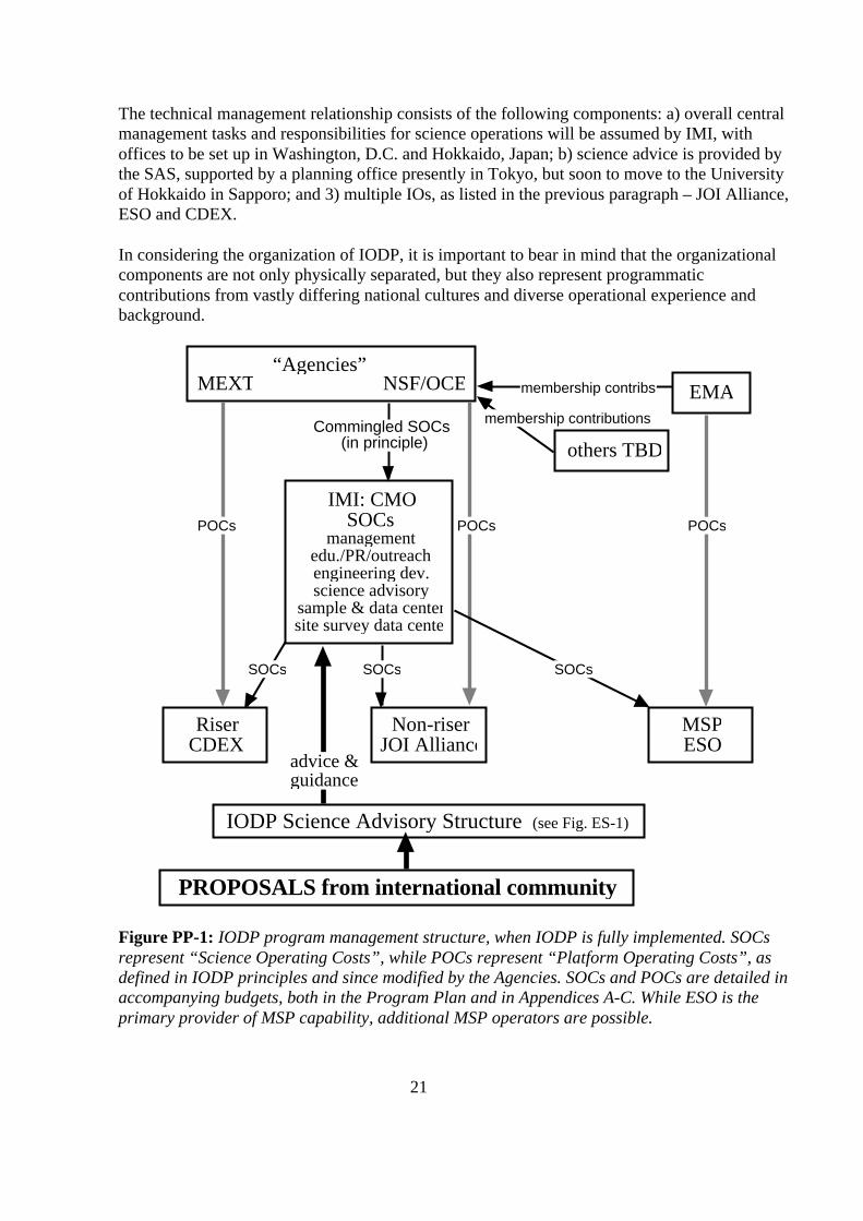
Overall management of science operations will be provided by IODP Management International,Inc. (IMI), which is currently negotiating a long-term contract with NSF to undertake the tasksand assume the responsibilities of the Central Management Organization (CMO, Figure ES-2).A provisional organizational chart for IMI is presented (Figure ES-3). IMI will be tasked withdelivering the science prioritized by SAS, in coordination with the Implementing Organizations(IOs).

7
Develop: Execute:• Annual Program Plan• Budget plan for Science Operation Cost of the
program• Budget plan for technical/engineering development• Downhole logging plan and budget• Annual publication and information service plan,
budget, and guidelines for the Program• Annual plan and budget for education, outreach,
and promotion
• Contracts with IOs or IODP subcontractorsfor Science Operation Activities
• Contracts with IOs or IODP subcontractorsfor technical/engineering development
• Contract (or other agreement) withNSF/MEXT for science operations andmanagement of IODP
• Other contracts/agreements which may berequired
Ensure the efficiency of: Secure or Maintain:• Detailed annual Science Operating Plan• Detailed annual Platform Operation Plan• Detailed Science Operation Cost• Detailed drilling plan prepared by IO and DPG• Platform Operation Cost of the Program• Detailed Pre-drilling site survey plan prepared by
IO
• Necessary funding for Science Operation ofeach platform
• Financial controls for the Science OperationCost of the Program
• Necessary funding for publication andinformation services
• Fiscal activities of CMO operations• Quality control for sample and data archives
Seek or Promote: Support or Assist:• International cooperation to provide timely and
useful site survey info for the proposed drill sites• Advice from the drilling industry on
operational/technical solutions• New members for IODP
• Appropriate pre-drilling site survey standardfor each platform to meet adequate HSErequirements
• IO to secure drilling permit from the countryof jurisdiction
• DPG and IO in creating detailed drillingplans
Conduct: Support SAS Activities & Ops:• Promotion of the Program • SAS Support and Logistics
• Proposal Administration• Publication and Outreach
Figure ES-2: CMO tasks and responsibilities, based on recommendations from SAS andImplementing Organizations, and approved by the IWG. These tasks and responsibilitieswill be the undertaken and assumed by IODP Management International, Inc. (IMI),under long-term contract to NSF.
Implementing Organizations
IODP is the first scientific ocean drilling program to have more than one IO (ImplementingOrganization, i.e., drilling operator). Non-riser drilling capability will be supplied by the JOIAlliance, a partnership of JOI, Inc. (overall management), Texas A&M University (operation ofthe non-riser drillship, the JOIDES Resolution in the first phase of IODP, and associatedactivities of expedition staffing, logistics, program-specific engineering development andoperations, shipboard laboratories, curation and distribution of core samples and data) and

8
Lamont-Doherty Earth Observatory of Columbia University (geophysical and geochemicallogging services, involving acquisition, processing and interpretation of logging measurements).The ECORD Science Operator (ESO) will supply mission-specific platform (MSP) drilling andlogging capabilities. The ESO is a consortium led by the British Geological Survey (MSPoperations and program-specific engineering development), the European PetrophysicsConsortium (logging services) and the University of Bremen (repository services). Riser drillingcapability using the vessel Chikyu will be supplied by the Center for Deep Earth Exploration(CDEX). These relationships are outlined (Figure ES-4).
PresidentManik Talwani
1 FTE
IMI BoG
Admin. Assist1 FTE
Ex. Prog. Assoc.1 FTE
VP IODPScience Ops.
1 FTE
VP IODPSci. Deliverables
1 FTE
SampleRepositories
($2M)
Ops. Coord.1 FTE
Engin. Dev.1 FTE
ContractsOfficer0.5 FTE
FinanceOfficer0.5 FTE
Office IT Supp.1 FTE
Edu/Outreach/Pubs. sc1 FTE
SAS Office Japan, etc.($0.54M)
Site SurveyDatabank($0.6M)
Data Manage.sc
1 FTE
Admin. Assist1 FTE
Admin. Assist1 FTE
Admin. Assist1 FTE
NB: ∑14 FTEgray box = functionality, no FTE @ IMIsc = subcontract. IMI FTE administers
Science Programs & Planning Administrative Services
Figure ES-3: Prospective organization of IODP Management International, Inc. (IMI). In thediagram, “sc” stands for a subcontract (i.e., IMI administration of a particular task, like datamanagement or publications, actually conducted external to the corporation). FTE means “full-time equivalent”. The number of FTEs to be employed by IMI is still under discussion. Amountsin some boxes refer to estimates of resources anticipated for those tasks. Please note that theSAS Office is part of IMI, although it is listed as a subcontract.
The JOI Alliance is under contract to NSF, ESO will operate under the auspices of the EuropeanManagement Agency (EMA) based in Paris, and CDEX is part of the Japan Marine Science andTechnology Center (JAMSTEC). The Site Survey Data Bank prepares safety packages for pre-expedition review of designated sites, and supplies each shipboard scientific party with thegeophysical data necessary to conduct scheduled drilling expeditions properly. The Data Bank

9
also assists scientists interested in developing IODP proposals by providing information withrespect to scientific problems of interest to the scientific ocean drilling community. In FY2004,resources to operate the Data Bank will be provided by NSF, through the ODP contract with JOI.
IMI
IODP Management International, Inc. (IMI) is a non-stock corporation incorporated in the U.S.IMI is presently negotiating a contract with NSF to provide the services of a CentralManagement Organization (CMO) for IODP (see Figure ES-2). IMI was incorporated in March2003, and shortly thereafter, an interim planning office was established at The University ofTexas at Austin, Institute for Geophysics (UTIG). Paul Stoffa, Director of UTIG, has beenserving as interim President of IMI, while James Austin has been serving as interim IODPdirector. The interim office has accomplished the following tasks: advertising for permanent IMIofficers (a President and one Vice President have been hired, see Figure ES-3), calling aninaugural meeting of IOs to discuss topics of mutual interest (e.g., databases, tool development,HSE), initiating an international effort to coordinate education and outreach, and liaising asnecessary to SAS committee and panel meetings in order to provide continuity between scienceadvice and guidance and program management. A permanent IMI office should be established by~1 April 2004.

10
NSF/OCEMEXT EMA
RiserCDEX
MSPESO
Non-riserJOI Alliance
IMI: CMOSOCs
managementedu./PR/outreachengineering dev.science advisory
sample & data centersite survey data center
POCs POCsPOCs
Commingled SOCs (in principle)
membership contribs
others TBD
SOCs SOCs SOCs
advice &guidance
IODP Science Advisory Structure (see Fig. ES-1)
PROPOSALS from international community
membership contributions
“Agencies”
Figure ES-4: IODP program management structure, when IODP is fully implemented. SOCsrepresent “Science Operating Costs”, while POCs represent “Platform Operating Costs”, asdefined in IODP principles and since modified by the Agencies. SOCs and POCs are detailed inaccompanying budgets, both in the Program Plan and in Appendices A-C. While ESO is theprimary provider of MSP capability, additional MSP operators are possible.
Science Advisory Office
Establishing an IODP Science Advisory Office (SAO) to support the activities of the designatedSPPOC and SPC chairs, not to be confused with the Science Advisory Structure (SAS) Office(see Figure ES-1), is mandated in the IODP memorandum between MEXT and NSF, which wassigned on 22 April, 2003. The SAO is being implemented gradually at the Ocean ResearchInstitute, University of Tokyo, beginning with the appointments of the SPPOC chair (KensakuTamaki) and SPC chair (Mike Coffin) in August and September 2003, respectively, and thehiring of a full-time administrative assistant (Yamaguchi) in November 2003. Fullimplementation of the SAO is anticipated during the second quarter of calendar 2004, when the

11
source of support for the SAO will shift from JAMSTEC and Joint Oceanographic Institutions,Inc. (JOI) to IMI.
Science Advisory Structure (SAS) Office
The SAS Office manages the IODP proposal process, coordinates and supports SAS activities,and facilitates communication among the SAS, IODP management entities and the internationalscientific drilling community (see Figure ES-1). The SAS Office also contributes content toprogram plans and assists and coordinates the activities of the Science Planning and PolicyOversight Committee (SPPOC), Operations Committee (OPCOM) and other detailed andprogram planning groups mandated by Science Planning Committee (SPC). The SAS office staff(science coordinators Nobu Eguchi and Jeff Schuffert, and administrative assistant Komamura)maintains close working relationships with the chairs of the SPPOC and the SPC (through theSAO), and the interim IMI office at UTIG (to be replaced by IMI ~1 April 2004). The AdvancedEarth Science and Technology Organization (AESTO) organizes and supports the SAS Office,and JAMSTEC currently provides office space, infrastructure and equipment. The source ofsupport for the SAS Office will shift from JOI to IMI in the second quarter of calendar year 2004,when the current office in Tokyo relocates to Hokkaido, Sapporo, and becomes the permanentSAS/IODP Office, part of IMI.
Project Management
A Project Management System (PMS) has been proposed for use in all IODP expeditions by theProject Management System Working Group (PMSWG) mandated by the SPC. The PMSrepresents a phased approach, with reviews at specified intervals during so-called scoping,implementation and evaluation phases, providing assurance that each IODP expedition makesprogress towards its goal(s). PMS makes maximum use of previous scientific ocean drillingpractices and allows for flexibility in application, depending on the platform(s) selected forspecific expeditions (riser, non-riser and/or MSP) and the complexity of the planned activities.The main objective of the PMS is to provide IODP management and its funding bodies withassurance that acceptable HSE and drilling standards are met at all stages of expedition planning,that value is achieved, and that all aspects related to envisioned operations are considered. PMSis based on standard industry project-management practices. The PMSWG has recommended atest to confirm the extent to which PMS can be implemented in practice in IODP. The PMSWGhas further recommended that after a relatively short implementation interval (e.g., 18 months),the performance of the PMS be evaluated and modified as appropriate.
Project Scoping
As part of the PMS, a Project Scoping Working Group (PSWG) has been established by SPC tobegin the scoping process for two proposed complex drilling projects (CDPs). To date, theSSEPs consider two Seismogenic Zone proposals, 603-NanTroSEIZE and 537-Costa Rica, to beCDPs. A CDP has one or more clearly articulated, overarching scientific goal(s); achieving thegoal(s) requires completing linked scientific and operational components, each of which can beaccomplished in a reasonably short time. However, the fundamental goal(s) of a CDP cannot beachieved through completion of a series of independent drilling expeditions, but must instead be

12
part of a planned and coordinated (and perhaps multi-year and multi-platform) activity. ThePSWG first met in August 2003. The scoping process includes expedition description, riskanalyses and long-term operational planning. Membership has included representatives fromproponent groups and IOs, an industry project management advisor, a risk identificationspecialist and a well engineer.
A project-scoping group under the PMS has also been established for 533-Central ArcticPaleoceanography. This Arctic Scoping Group (ASG) first met in October 2003. Establishmentof a project-scoping group for 595-Indus Fan (and Murray Ridge) was also endorsed by the SPCin September 2003; that group may be formed before the end of calendar year 2003.
Coordination of the IODP Program Plan
IODP scientific expeditions are based on proposals submitted by the international sciencecommunity to the SAS Office (see Figures ES-1 and ES-4). SAS advisory panels review theseproposals and then make recommendations to the SPC that ranks proposals, and decidesoperational matters with the advice and guidance of the OPCOM. After scheduling has beencompleted, SPC writes a science plan and submits it to IMI. In turn, IMI prepares the ProgramPlan from the science plan with budgetary input on operations from the IOs (JOI Alliance, ESOand CDEX, see appendices A-C) and from the Agencies. The draft Program Plan is thenreviewed by SPPOC, an IMI committee, and finally forwarded by IMI to NSF and MEXT forformal approval.
SOCs and POCs
The costs of IODP are divided into two categories, Platform Operation Costs (POCs) andScience Operation Costs (SOCs). These were originally discussed and agreed upon by the IODPInternational Working Group. Subsequently, they were codified in the IODP memorandumsigned by NSF and MEXT in April 2003, and are excerpted below. Modifications to thiscategorization may occur through consultation with and concurrence of the Agencies. At the timethat this Program Plan was written, IMI had received no further details concerning definitions ofPOCs and SOCs.
Platform Operations Costs are expected to support the basic operation of thevessel as a drillship, and include, for example: (1) costs of the drilling and ship’screw; (2) catering services; (3) fuel, vessel supplies and other relatedconsumables; (4) berthage and port call costs; (5) disposal of wastes; (6) crewtravel; (7) inspections and insurance; (8) drilling equipment, supplies, and relatedconsumables; (9) engineering or geophysical surveys, and data acquisition andlaboratory analyses required for the safety of platform and drilling operations; and,(10) administration and management costs of the platform operators.
Science Operation Costs are expected to provide for those activities onboardprogram platforms necessary to the proper conduct of the scientific researchprogram and those shore-based activities required to properly maintain anddistribute samples and data, support seagoing activities, and administer and

13
manage the program. These costs include, for example: (1) technical services; (2)computer capability; (3) data storage and distribution; (4) description, archiving,and distribution of data and samples; (5) deployment of a standard suite oflogging tools; (6) development of new drilling tools and techniques required byIODP research; (7) program publications; (8) costs of consumables (exclusive ofthose identified under platform operations costs); and, (9) costs required foradministration and management, including the Central Management Office.
Scientific Highlights of the FY04-05 Science Program
Specific details concerning science operations for FY04 are presented in the Program Plansection (Section C) of this document. Here, we provide a brief summary of these operations.
Planning Phase: At the August 2002 meeting of the interim Planning Committee, the centralArctic MSP program was ranked first of five MSP programs considered ready for ranking at thattime. In September 2003, at its first global ranking of available IODP drilling proposals, the SPCconducted a competitive evaluation of 16 externally reviewed proposals sent by the ScienceSteering and Evaluation Panels (SSEPs, see Figure ES-1), and reaffirmed the previousevaluation of the externally reviewed central Arctic proposal, resulting in the selection of fournon-riser expeditions and one Arctic MSP expedition that are described in this Program Plan.The scheduled programs (see Figure ES-5) all directly address principal themes of Earth,Oceans, and Life, the IODP Initial Science Plan (ISP).
• One expedition, Juan de Fuca Ridge Flank Hydrogeology (545-Full3), addresses thedeep biosphere and the subseafloor ocean.
• Three expeditions, Central Arctic Paleoceanography (533-Full3), North AtlanticNeogene-Quaternary Climate (572-Full3) and Norwegian Margin Bottom Water (543-Full2), address environmental change, processes and effects.
• One expedition, Atlantis Oceanic Core Complex (512-Full3), addresses solid earthcycles and geodynamics.
• In addition, the Central Arctic Paleoceanography (533-Full3) expedition will drill thecentral Arctic Ocean for the first time, and represents the first dedicated MSP activityperformed under the auspices of international scientific ocean drilling.
2. IODP science plan summary for FY04
Brief summaries of the scientific objectives of selected IODP FY04 (and provisional FY05)expeditions (see Table ES-1 and Figure ES-5a.) are as follows:
Juan de Fuca Ridge Flank Hydrogeology (545-Full3) – Expedition 1/300
This multidisciplinary research program will evaluate the formation-scale hydrogeologicproperties (transmission, storage) within oceanic crust; determine how fluid pathways aredistributed within an active hydrothermal system; establish links between fluid circulation,alteration, and geomicrobial processes; and determine relations between seismic and hydrologicanisotropy. To accomplish these goals, two existing sub-seafloor observatories penetrating the

14
upper crust will be replaced, and two new holes (600 m and 200 m into the crust) will be drilled,cored, sampled, instrumented and sealed. The first multi-dimensional, cross-hole experimentsever attempted in oceanic crust will be conducted, including hydrologic, microbiological, seismicand tracer components. Following drilling, multi-year tests using this network of sub-seafloorobservatories will allow examination of a much larger volume of the crustal aquifer system thanhas been tested previously. By monitoring, sampling, and testing within multiple depth intervals,the extent to which oceanic crust is connected vertically and horizontally, the influence of theseconnections on fluid, solute, heat and microbiological processes, and the importance of scalingon hydrologic properties, will all be evaluated. The study area is characterized by: a) thicksediment cover isolating permeable basement, allowing small pressure transients to travel longlateral distances, b) outstanding coverage of seismic, heat flow, coring, geochemical andobservatory data, allowing detailed hypotheses to be posed and tested, c) existing ODP drillholes and long-term observatories, providing critical monitoring points for pre- and post-drillingexperiments, d) a naturally over-pressured formation that will drive multi-year, cross-holeexperiments, and e) a planned, cabled seafloor observatory network that will facilitate long-termexperiments, data access and instrument control. This expedition and associated work willelucidate the nature of permeable pathways in the crust, the depth extent of circulation, theimportance of permeability anisotropy and the significance of hydrogeologic barriers in the crust.It will demonstrate where viable microbiological communities live and how these communitiescycle carbon, alter rocks and are influenced by flow paths. It will also quantify lateral scales overwhich solute transport occurs, the extent of flow channeling and mixing in the crust, and howthese processes relate to rock structure and fabric. Finally, it will determine how to relate seismicvelocities and velocity anisotropy to hydrogeologic properties.
Central Arctic Paleoceanography (533-Full3) – Expedition MSP-1
The Lomonosov Ridge in the central Arctic Ocean rifted and separated from the continental shelfof the Kara and Barents Sea during early Paleogene time, and has subsequently subsided to itspresent water depth. Sediments of biogenic, eolian and ice-rafted origins have accumulated onthe ridge crest. Five drill sites on the Lomonosov Ridge crest, all in international waters, aredistributed between 81°N and 88°N, in water depths ranging from 800 to 1415 m (see FigureES5 b. and c.). In the primary target area between 87°N and 88°N, the presumed pelagic cap offlat-lying sediment is ~450 m thick, indicating an average sedimentation rate of ~10 m/mythroughout Cenozoic time. Sampling of these sediments will provide an unprecedented andunique opportunity to acquire first-order knowledge about the paleoceanographic history of thecentral Arctic Ocean. Sampling of the underlying bedrock provides a similarly uniqueopportunity to decipher the tectonic history of the Lomonosov Ridge and the formation of theEurasian Basin. Scientific objectives are to investigate: a) the long-term (<50 Ma) climate historyof the central Arctic Ocean and its role in the transition from one global climate extreme(Paleogene greenhouse, lacking glaciation) to another (Neogene icehouse, exhibiting bipolarglaciation), b) the shorter-term (Neogene) climate history, and connecting that history in theArctic Ocean to that in the North Atlantic Ocean at sub-millennial scale resolution, c) thecomposition and origin of the pre-Cenozoic bedrock underlying the sediment drape, and d) therifting and subsidence history of the Lomonosov Ridge. The widely spaced latitude and partlyoverlapping goals of the five drill sites will make the overall expedition less vulnerable to localice conditions. These major goals can be achieved by completing one site (i.e., multiple

15
penetrations to assure recovery of a complete section) to 450 mbsf, the approximate base of thepelagic cap. If ice conditions prohibit success at the first site, a suite of sites from other areasalong the Lomonosov Ridge corridor will be drilled as ice conditions permit to achieve theproposed science (see Figure ES-5 b. and c.).
N. Atlantic Neogene-Quaternary Climate (572-Full3) – Expedition 2/301 & 5/304a
The objectives of these two expeditions are to inter-calibrate late Neogene-Quaternarygeomagnetic paleointensity records, isotope stratigraphies and regional environmentalstratigraphies, and thereby develop a millennial-scale stratigraphic template for the past fewmillion years. Such a template is required for understanding the relative phasing of atmospheric,cryospheric and oceanic changes that are central to our understanding of the mechanisms ofglobal climate change on orbital to millennial time scales. In addition, the high-resolutionrecords of directional, secular variation and geomagnetic paleointensity will greatly improve ourknowledge of the temporal and spatial behavior of the geomagnetic field, as well as providefundamental constraints for numerical models of the geodynamo. Previous drilling and pistoncoring results indicate that the proposed drill sites: a) contain distinct records of millennial-scaleenvironmental variability in terms of ice-sheet–ocean interactions, deep circulation changes andsea-surface conditions, b) provide the requirements for developing a millennial-scale stratigraphythrough geomagnetic paleointensity, oxygen isotopes and regional environmental patterns, and c)document the details of geomagnetic field behavior. The nine proposed drill sites are located inthe Labrador Sea, the Irminger Basin, on the Eirik Drift off Orphan Knoll, on the southern part ofthe Gardar Drift, and at DSDP Site 607/609. (Note: Only the Labrador Sea, Irminger Basin andEirik Drift sites will be addressed in FY04.) These sites preserve components of ice-sheet–oceaninteractions, with potential for chronological control through stable isotopes and geomagneticpaleointensity. Some are located within the North Atlantic belt of ice-rafted debris, betweenprevious drilling sites to the north (60- 77˚N; ODP Leg 162) and south (30-35˚N; ODP Leg 172).These sites also lie in an appropriate bathymetric depth range, 2750 to 3719 m, for detectingmillennial-scale changes in the formation of deep and intermediate water masses.
Atlantis Oceanic Core Complex (512-Full2) – Expedition 3/302 & 4/303
These two expeditions will investigate the conditions under which oceanic core complexesdevelop. Domal massifs capped by corrugated, striated detachment faults have been mapped atseveral locations on the seafloor. These large, shallow seafloor features apparently form as aresult of episodic plate rifting and accretion at slow spreading ridges. However, currentlyavailable data are insufficient to characterize the magmatic, tectonic and metamorphic historyand to understand the mechanisms of uplift and emplacement of oceanic core complexes. Theprimary goal is to drill through the basaltic hanging wall of Atlantis Massif, in order to samplerock from just above the detachment, the shallowest part of the unexposed fault, and through aportion of the fault zone. A second goal is to characterize the nature of the alteration front withinoceanic peridotite. Oceanic core complexes expose altered upper mantle peridotites and maficcrustal rocks. The alteration of these rocks and the process of serpentinization greatly affect thegeophysical properties of the lithosphere. Mantle seismic velocities have been measured atdepths as shallow as several hundred meters on the central dome of the massif; therefore, drillingat Atlantis Massif offers an unprecedented opportunity to determine the nature of the Moho, i.e.,

16
to test whether it represents a hydration front or the crust–mantle boundary. The potential forrecovering fresh peridotite at Atlantis Massif also presents excellent opportunities for advancesin understanding residual modes and microstructure within the oceanic mantle. Cores ofessentially fresh, in-situ peridotite will allow documentation of composition, microstructure,evidence for melt production and migration, and relationships among deformation, melt andsyntectonic alteration. Drilling a deep hole on the central dome of Atlantis Massif will also allowsampling of the detachment fault zone and the alteration front, and will penetrate and enablerecovery of unaltered mantle.
Norwegian Margin Bottom Water Expedition (543-Full2) – Expedition 5/304b
Knowledge of bottom-water temperature (BWT) variations is important for understanding thevigor and nature of ocean circulation, as well as the nature of climatic interactions between theocean and atmosphere. The biggest obstacles to understanding variability in bottom water are: a)the lack of an observational network and b) historical records that are too brief and too sparselyspaced. This expedition will investigate the feasibility of reconstructing BWT histories on adecadal to centennial time scale by making highly precise temperature measurements in ODPHole 642E on the Norwegian margin. Because marine sediment has a low thermal diffusivity,variations in BWT propagate slowly downward, perturbing the background thermal field. Thesetemperature anomalies are a direct thermo-physical consequence of a changing BWT conditionand will therefore be used to reconstruct BWT histories. To ensure a conductive thermalenvironment, a thermistor string will be isolated between a borehole seal, or CORK (“circulationobviation retrofit kit”), at the top of the borehole and a packer below the thermistor string. Hole642E is ideally located in the climatically sensitive Norwegian-Greenland Sea, with a 50-yeartime-series of BWT measurements taken and available nearby. A sensitivity analysis usingobserved variations in BWT at this location indicates the presence of a resolvable signal.Thermal transients will be measured as a function of time at this borehole observatory, in orderto isolate directly the transient component of BWT variations.
17
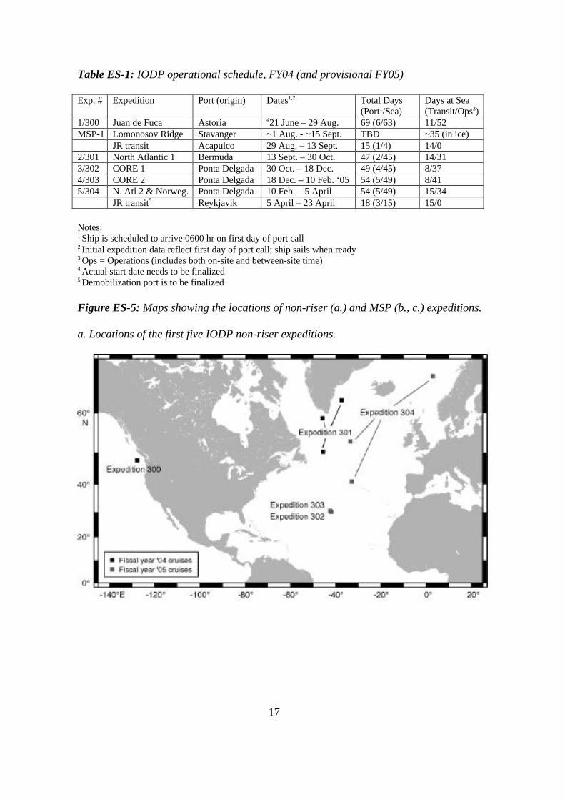
Table ES-1: IODP operational schedule, FY04 (and provisional FY05)
Exp. # Expedition Port (origin) Dates1,2 Total Days(Port1/Sea)
Days at Sea(Transit/Ops3)
1/300 Juan de Fuca Astoria 421 June – 29 Aug. 69 (6/63) 11/52MSP-1 Lomonosov Ridge Stavanger ~1 Aug. - ~15 Sept. TBD ~35 (in ice)
JR transit Acapulco 29 Aug. – 13 Sept. 15 (1/4) 14/02/301 North Atlantic 1 Bermuda 13 Sept. – 30 Oct. 47 (2/45) 14/313/302 CORE 1 Ponta Delgada 30 Oct. – 18 Dec. 49 (4/45) 8/374/303 CORE 2 Ponta Delgada 18 Dec. – 10 Feb. ‘05 54 (5/49) 8/415/304 N. Atl 2 & Norweg. Ponta Delgada 10 Feb. – 5 April 54 (5/49) 15/34
JR transit5 Reykjavik 5 April – 23 April 18 (3/15) 15/0
Notes:1 Ship is scheduled to arrive 0600 hr on first day of port call2 Initial expedition data reflect first day of port call; ship sails when ready3 Ops = Operations (includes both on-site and between-site time)4 Actual start date needs to be finalized5 Demobilization port is to be finalized
Figure ES-5: Maps showing the locations of non-riser (a.) and MSP (b., c.) expeditions.
a. Locations of the first five IODP non-riser expeditions.

18
b. Locations of the proposed MSP coring sites in the central Arctic, Expedition MSP-1.
c. Bathymetric relief map showing the proposed MSP drill sites on the central Arctic’sLomonosov Ridge, Expedition MSP-1.

19
3. FY04 Budget Overview
The FY04 budget reflects the Science Operation Costs and Platform Operation Costs (SOCs andPOCs) associated with non-riser and MSP expeditions, and with activities in support of riseroperations that are scheduled to begin in FY07. The budget total of $40,014 K meets the high-priority needs identified by the IODP SAS. The process by which the budget was developed isexplained below, in the Program Plan section. Detailed budget information from the IOs isavailable in the appendices. Table ES-2 summarizes the FY04 budget. The budgets of the IODPentities are divided into POCs and SOCs. In FY04, the SOCs total 38% of the budget, whereasPOCs make up the majority, at 62%.
Table ES-2: IODP summary budget for FY04 ($K).
Entity Specifics SOCs POCs Total ($K)IMI TOTAL * 2,000$ -$ 2,000$
JOI AllianceJOI 730$ 1,080$ 1,810$ TAMU 6,889$ 10,438$ 17,327$ LDEO 2,367$ 618$ 2,984$ TOTAL 9,986$ 12,136$ 22,121$
ESOPlanning & maintenance 694$ 25$ 719$ Arctic expedition 2,061$ 9,713$ 11,774$ TOTAL ** 2,755$ 9,738$ 12,493$
CDEX TOTAL 318$ 3,082$ 3,400$
Grand TOTAL 15,059$ 24,956$ 40,014$
* Excludes subcontracts for database, repositories, and engin. dev.SAS/SAO office costs are included, but amounts are not specified.NSF ODP funds, through JOI, will support the data bank in FY04. IMI will beresponsible for providing data bank services in FY05 and beyond.** Excludes the commingled SOCs contribution to the EMA office.

20
C. FY04 IODP Program Plan
1. IODP Organizational Framework and Entities
Organizational Framework
According to the principles upon which the Integrated Ocean Drilling Program (IODP) has beenfounded, the “Science Operating Costs” (SOCs) of the IODP will be supplied to the not-for-profit corporation IODP Management International, Inc. (IMI), which will provide the CentralManagement Organization (CMO) functionality for the Program (see Figure PP-1). In turn, IMIwill distribute SOCs to Implementing Organizations (IOs, drilling operators) and to othersubcontractors according to the budgets outlined in this and subsequent IODP annual ProgramPlans. SOC funds will be collected from IODP members, commingled by the U.S. NationalScience Foundation (NSF), and provided through contract to IMI (see Figure PP-1). Currently,the U.S. NSF and Japan, as represented by the Ministry of Education, Culture, Sports, Scienceand Technology (MEXT), are IODP members and referred to as “Agencies.”
A European consortium of at least 15 countries intends to join IODP in ~December 2003. Thisconsortium is named European Consortium for Ocean Research Drilling (ECORD), and aEuropean Management Agency (EMA) will represent the ECORD funding agencies. China isalso pursuing membership in IODP.
The Agencies will establish an IODP Council that: a) provides governmental oversight for allIODP activities, b) assures effective planning, management and operation of the IODP and c)encourages and promotes broad international participation in the IODP. The Council membersare to be representatives from each country or entity contributing support to the IODP. The Chairof the Council is to be from the Agencies and is to alternate between them on a yearly basis. TheCouncil is expected to meet at least once per year. The agenda and site for all meetings isexpected to be decided through mutual understanding. The responsibility for meetingarrangements is to reside with the Chair. The Chair is expected to be responsible for developingthe meeting agenda, in consultation with the other Agency. Meetings of the Council may be opento participation by others through mutual confirmation of the Agencies. The Council is expectedto serve as a consultative body reviewing financial, managerial and other matters involving theoverall support of the IODP. A formal agenda is to be prepared for each meeting and writtenrecords are to be kept. Liaison representatives from the CMO (IMI), IOs, and Science AdvisoryStructure (SAS) are expected to be available to the Council.
As detailed in Figure PP-1, “Platform Operating Costs” (POCs) are supplied directly fromindividual funding agencies of the countries or consortia operating IODP drilling assets: fromNSF to the JOI Alliance (JOI, Inc., Texas A&M University, Lamont-Doherty Earth Observatoryof Columbia University) for operation of the non-riser vessel (JOIDES Resolution in the firstphase of IODP), from MEXT to the Center for Deep Earth Exploration (CDEX) for continuedoutfitting of the riser ship Chikyu and all preparation activities in support of internationaloperations expected to start in FY2007, and from ECORD to the ECORD Science Operator(ESO) for Mission-Specific Platform (MSP) operations.
21
The technical management relationship consists of the following components: a) overall centralmanagement tasks and responsibilities for science operations will be assumed by IMI, withoffices to be set up in Washington, D.C. and Hokkaido, Japan; b) science advice is provided bythe SAS, supported by a planning office presently in Tokyo, but soon to move to the Universityof Hokkaido in Sapporo; and 3) multiple IOs, as listed in the previous paragraph – JOI Alliance,ESO and CDEX.
In considering the organization of IODP, it is important to bear in mind that the organizationalcomponents are not only physically separated, but they also represent programmaticcontributions from vastly differing national cultures and diverse operational experience andbackground.
NSF/OCEMEXT EMA
RiserCDEX
MSPESO
Non-riserJOI Alliance
IMI: CMOSOCs
managementedu./PR/outreachengineering dev.science advisory
sample & data centersite survey data center
POCs POCsPOCs
Commingled SOCs (in principle)
membership contribs
others TBD
SOCs SOCs SOCs
advice &guidance
IODP Science Advisory Structure (see Fig. ES-1)
PROPOSALS from international community
membership contributions
“Agencies”
Figure PP-1: IODP program management structure, when IODP is fully implemented. SOCsrepresent “Science Operating Costs”, while POCs represent “Platform Operating Costs”, asdefined in IODP principles and since modified by the Agencies. SOCs and POCs are detailed inaccompanying budgets, both in the Program Plan and in Appendices A-C. While ESO is theprimary provider of MSP capability, additional MSP operators are possible.

22
Program Manager
A Central Management Organization (CMO) will be established with the concurrence of MEXTand NSF to develop and manage science operations and implementation plans for the IODP. TheCMO will be provided by IMI, Inc. through a long-term contract with NSF. As of November2003, this contract is under negotiation. The CMO: a) receives advice and recommendations onscientific priorities and plans from the SAS, b) requests plans that are responsive to this advicefrom IOs, and c) negotiates with IOs and the SAS to produce an integrated annual IODPProgram Plan. The annual Plan is to be consistent with budget guidance provided to IMI by theAgencies. The annual Plan includes a presentation of total program costs, which include bothSOCs and POCs. IMI will manage SOCs funds provided under contract with the NSF. The NSFis expected to administer the contract with due consideration to the interests of MEXT. POCswill be provided directly to the IOs from the Agencies and ECORD through the EMA (FigurePP-1).
We present a provisional organizational wiring diagram of IMI (Figure PP-2). IMI providescontractual, management and fiscal links for science operations between NSF and the variousoperational and advisory components of IODP. IMI will have two offices, one in Washington,D.C., USA, and another at the University of Hokkaido, in Sapporo, Japan. Based on initialestimates, the Washington, D.C. office will have ~14 “full-time equivalent” (FTE) employees.
IMI will submit the annual IODP Program Plan to the Science Planning and Policy OversightCommittee (SPPOC), the executive authority of the SAS and an IMI committee, for review andapproval prior to consideration by the Agencies. The NSF has responsibility to approvecontractually the annual IODP Program Plan, in consultation with MEXT. After approval by theAgencies, significant changes in the annual IODP Program Plan are to be considered andapproved by IMI and the Agencies prior to implementation, in consultation with the SPPOC andthe IOs, as appropriate.

23
PresidentManik Talwani
1 FTE
IMI BoG
Admin. Assist1 FTE
Ex. Prog. Assoc.1 FTE
VP IODPScience Ops.
1 FTE
VP IODPSci. Deliverables
1 FTE
SampleRepositories
($2M)
Ops. Coord.1 FTE
Engin. Dev.1 FTE
ContractsOfficer0.5 FTE
FinanceOfficer0.5 FTE
Office IT Supp.1 FTE
Edu/Outreach/Pubs. sc1 FTE
SAS Office Japan, etc.($0.54M)
Site SurveyDatabank($0.6M)
Data Manage.sc
1 FTE
Admin. Assist1 FTE
Admin. Assist1 FTE
Admin. Assist1 FTE
NB: ∑14 FTEgray box = functionality, no FTE @ IMIsc = subcontract. IMI FTE administers
Science Programs & Planning Administrative Services
Figure PP-2: Prospective organization of IODP Management International, Inc. (IMI). In thediagram, “sc” stands for a subcontract (i.e., IMI administration of a particular task, like datamanagement or publications, actually conducted external to the corporation). FTE means “full-time equivalent”. The number of FTEs to be employed by IMI is still under discussion. Amountsin some boxes refer to estimates of resources anticipated for those tasks. Please note that theSAS Office is part of IMI, although it is listed as a subcontract.
Science Advisory Structure
The IODP Science Advisory Structure (SAS) is composed of scientists, engineers andtechnologists designated by IODP member organizations, such as national or consortiaorganizations. The SAS provides long-term guidance on the scientific planning of the IODP, andrecommends annual science and engineering plans based on proposals from the internationalscience community. The initial scientific objectives of IODP are listed in the IODP InitialScience Plan (ISP) (www.iodp.org/isp.html). Through SAS-sponsored activities, these objectivesare pursued, reaffirmed and modified as appropriate by the SAS, and by other internationalscientists, engineers and technologists engaged in ocean drilling. The SAS consists of severaladvisory committees, panels and groups (see Figure PP-3) containing hundreds of scientistsfrom the international geoscience community in IODP member countries and consortia. The SASprovides planning and program advice and guidance to IMI with regard to scientific goals andobjectives, facilities, scientific personnel and operating procedures. In turn, IMI provides supportfor SAS planning in the form of SOCs.

24
The Science Planning Committee (SPC) Chair, Vice Chair and the SAS planning officecoordinate the SAS. The SAS Office will be permanently based in Hokkaido, Japan, and willprovide support for all aspects of the SAS, including the SPC and the Science Planning andPolicy Oversight Committee (SPPOC). The Chairs of the SPC and the SPPOC will receivefinancial and administrative support through the Science Advisory Office (SAO). The SPC Chairrotates every two years. The current Chair is Mike Coffin of the Ocean Research Institute (ORI)of the University of Tokyo. The Vice-Chair-Elect is James Austin, of the University of Texas atAustin, Institute for Geophysics. The Chair of SPPOC is Kensaku Tamaki of ORI. SPC andSPPOC Chairs are expected to rotate, on a 2-year basis, initially between institutions in Japanand the USA.
The SPPOC, which heads the SAS, is considered the “Executive Authority” and is composed ofrepresentatives from scientific organizations in the IODP member countries that have a majorinterest in the study of the sea floor. However, SPPOC is a committee of IMI. The SPPOCformulates scientific and policy recommendations with respect to IODP planning and operations.
The SAS may establish panels and/or committees as needed to address its responsibilities,including panels on platforms and on science operations. The Agency countries are entitled toequal representation on the SAS and all of its panels and committees. In FY04, after ECORDjoins IODP, ECORD will be entitled to have three voting members and one non-voting observeron each SAS panel and committee. The USA and Japan will likely be represented by up to sevenrepresentatives each.

25
SPPOCScience Planning and
Policy Oversight Comm .(IMI committee -
policy input and programplan approval)
SPCSci. Planning Comm .
(proposal ranking)
OPCOMOperations Comm.
(rules by consensusdevelops ops. planmonitors planningIOs are members)ESSEP
Environ. Sci. Steering &
Evaluation Panel(proposal evaluation
and nurturing)
ISSEPInterior Sci. Steering &
Evaluation Panel(proposal evaluation
and nurturing)
PPSPPollut. Prev. &
Safety Panel
SSPSite Survey
Panel
SCIMPSci. Measure.
Panel
TAPTech. Advice
Panel
ILPIndustry Liaison
Panel
SAOSci. Advisory OfficeSPC/SPPOC Chairs
SAS Office(receives proposalsprepares minutes
conducts external evals.)
Proposals from the international scientific community
“Science Advice” “Technical Advice”
Figure PP-3: IODP Science Advisory Structure (SAS). Technical and scientific advisory panelsliaise as necessary. Technical panels also liaise to OPCOM. Mandates for individual panels canbe found at http://www.ig.utexas.edu/imi/ (SPPOC) and www.isas-office.jp (all other panels).
Implementing Organizations
IODP is the first international scientific ocean-drilling program to have more than oneImplementing Organization (IO, drilling operator). The IOs receive SOCs from NSF by way ofIMI, and POCs directly from their national or consortia funding agencies (see Figure PP-1).
Non-riser drilling capability will be supplied by the NSF through a contract to the JOI Alliance(see Appendix A), consisting of JOI, Inc. (prime contractor and overall management), TexasA&M University (subcontractor that operates a non-riser drillship, and provides associatedservices and functions such as expedition staffing, logistics, program-specific engineeringdevelopment and operations, shipboard laboratories, curation, and distribution of core samplesand data) and Lamont-Doherty Earth Observatory of Columbia University (geophysical andgeochemical logging services aboard the non-riser vessel, involving acquisition, processing andinterpretation of logging measurements). In phase one of the IODP (extending to at least May
26
2005), the Alliance will provide the JOIDES Resolution as the non-riser vessel. Five non-riserexpeditions are planned between June 2004 and April 2005. A vessel, still to be determined, willbe refitted and provided by the Alliance as the phase two non-riser platform.
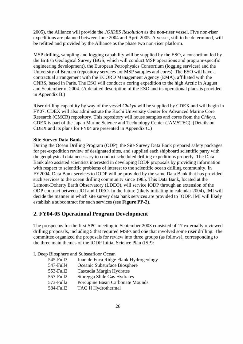
MSP drilling, sampling and logging capability will be supplied by the ESO, a consortium led bythe British Geological Survey (BGS; which will conduct MSP operations and program-specificengineering development), the European Petrophysics Consortium (logging services) and theUniversity of Bremen (repository services for MSP samples and cores). The ESO will have acontractual arrangement with the ECORD Management Agency (EMA), affiliated with theCNRS, based in Paris. The ESO will conduct a coring expedition to the high Arctic in Augustand September of 2004. (A detailed description of the ESO and its operational plans is providedin Appendix B.)
Riser drilling capability by way of the vessel Chikyu will be supplied by CDEX and will begin inFY07. CDEX will also administrate the Kochi University Center for Advanced Marine CoreResearch (CMCR) repository. This repository will house samples and cores from the Chikyu.CDEX is part of the Japan Marine Science and Technology Center (JAMSTEC). (Details onCDEX and its plans for FY04 are presented in Appendix C.)
Site Survey Data BankDuring the Ocean Drilling Program (ODP), the Site Survey Data Bank prepared safety packagesfor pre-expedition review of designated sites, and supplied each shipboard scientific party withthe geophysical data necessary to conduct scheduled drilling expeditions properly. The DataBank also assisted scientists interested in developing IODP proposals by providing informationwith respect to scientific problems of interest to the scientific ocean drilling community. InFY2004, Data Bank services to IODP will be provided by the same Data Bank that has providedsuch services to the ocean drilling community since 1985. This Data Bank, located at theLamont-Doherty Earth Observatory (LDEO), will service IODP through an extension of theODP contract between JOI and LDEO. In the future (likely initiating in calendar 2004), IMI willdecide the manner in which site survey data bank services are provided to IODP. IMI will likelyestablish a subcontract for such services (see Figure PP-2).
2. FY04-05 Operational Program Development
The prospectus for the first SPC meeting in September 2003 consisted of 17 externally revieweddrilling proposals, including 5 that required MSPs and one that involved some riser drilling. Thecommittee organized the proposals for review into three groups (as follows), corresponding tothe three main themes of the IODP Initial Science Plan (ISP):
I. Deep Biosphere and Subseafloor Ocean545-Full3 Juan de Fuca Ridge Flank Hydrogeology547-Full4 Oceanic Subsurface Biosphere553-Full2 Cascadia Margin Hydrates557-Full2 Storegga Slide Gas Hydrates573-Full2 Porcupine Basin Carbonate Mounds584-Full2 TAG II Hydrothermal

27
589-Full3 Gulf of Mexico Overpressures
II. Environmental Change, Processes and Effects482-Full3 Wilkes Land Margin519-Full2 South Pacific Sea Level MSP533-Full3 Central Arctic Paleoceanography MSP543-Full2 Norwegian Margin Bottom Water548-Full2 Chicxulub K-T Impact Crater MSP564-Full New Jersey Shallow Shelf MSP572-Full3 N. Atlantic Neogene–Quaternary Climate581-Full2 Late Pleistocene Coralgal Banks MSP595-Full3 Indus Fan and Murray Ridge Riser (partial)
III. Solid Earth Cycles and Geodynamics512-Full3 Atlantis Oceanic Core Complex
At the beginning of the meeting, the SPC endorsed a provisional conflict-of-interest (COI) policynearly identical to the one used previously in the Joint Oceanographic Institutions for Deep EarthSampling (JOIDES) Advisory Structure of the ODP. The COI policy stipulates that proponentsdepart from the proceedings during the discussion of their own proposal and that conflictedcommittee members exclude themselves from participating in any part of the ranking andscheduling process.
SPC Motion 03-09-3: The SPC endorses the conflict of interest policy proposed for provisionaluse at its first meeting.Katz moved, Miller seconded; 14 in favor.
Before outlining and discussing the procedure for reviewing and ranking proposals, the SPCdecided to forward Proposal 533-Full3 directly to the Operations Committee (OPCOM) withoutfurther review because of its history of favorable reviews, top ranking, advanced operationalplanning, and because IMI considered the program to be in the implementation phase.
SPC Motion 03-09-27: The SPC affirms the high scientific priority and potential of scientificdrilling in the central Arctic Ocean and recognizes that Proposal 533-Full3 Central ArcticPaleoceanography is currently in the implementation phase for operations anticipated for Augustand September 2004. The SPC therefore forwards this previously top-ranked proposal to theOPCOM without re-ranking for consideration for scheduling in FY2004.Prell moved, Miller seconded; 14 in favor.
Proposal review and ranking procedure
The SPC followed a review and ranking procedure that embodied the essential elements of theprocedure used previously by JOIDES Scientific Committee (SCICOM) during the ODP. Theparticipants declared at the outset any potential conflicts of interest regarding specific drillingproposals, and conflicted committee members were excluded from the discussion of their ownproposal as well as from the entire ranking and scheduling exercise. The SPC then evaluated

28
each proposal in terms of its relevance to the objectives and priorities of the IODP ISP. The leadwatchdogs presented the proposals, followed by comments and discussion among the committeemembers, panel chairs and other participants. After reviewing all of the proposals, the SPCdefined the pool of proposals for global ranking, conducted the ranking by signed paper ballots,and selected the group of ranked proposals to forward to OPCOM for possible scheduling.
Presentation and discussion of proposals
Upon completing the general presentation and discussion of the 16 proposals remaining in theprospectus, the SPC debated several specific options for how best to implement certain proposalsand whether or not they should consider those options in the ranking process. SPC eventuallyagreed not to consider operational judgments in the ranking and instead focused exclusively onthe scientific plans as presented in each proposal. The SPC also reached a consensus from ascientific perspective on the following points concerning Proposals 545-Full3 and 572-Full3.
SPC Consensus 03-09-28: The SPC regards the first part of Proposal 545-Full3 Juan de FucaRidge Flank Hydrogeology as worth scheduling on its own.
SPC Consensus 03-09-29: The SPC recommends requiring quadruple Advanced Piston Coring(APC) holes at each site of Proposal 572-Full3 North Atlantic Neogene–Quaternary Climate andpenetrating deeper than proposed at one site to obtain paleointensity records from beyond 3 Ma.
Global ranking of proposals
To preserve the maximum flexibility for developing a drilling schedule, the SPC agreed byconsensus to rank all 16 of the proposals reviewed at this meeting.
SPC Consensus 03-09-30: The SPC will rank all 16 of the proposals reviewed at this meeting.
The SPC conducted the ranking through a closed vote. Each member submitted a signed ballot,assigning the numerical rank of 1 through 16 to the full set of proposals. The iSAS Office staffcollected the ballots and tabulated the results, as shown below:
Rank Proposal # Short Title Mean St dev
1 519-Full2 South Pacific Sea Level 4.43 2.56
2 512-Full3 Atlantis Oceanic Core Complex 4.57 3.16
3 545-Full3 Juan de Fuca Ridge Flank Hydrogeology 4.64 3.88
4 564-Full New Jersey Shelf 5.21 3.81
5 589-Full3 Gulf of Mexico Overpressures 6.21 5.22
6 553-Full2 Cascadia Margin Hydrates 8.14 4.00
7 572-Full3 N. Atlantic Neogene–Quaternary Climate 8.64 3.67
8 482-Full3 Wilkes Land Margin 8.79 4.59
9 543-Full2 Norwegian Margin Bottom Water 9.14 3.96
10 547-Full4 Oceanic Subsurface Biosphere 9.50 3.25
29
11 595-Full3 Indus Fan and Murray Ridge 9.57 3.13
12 584-Full2 TAG II Hydrothermal 10.21 3.14
13(t) 557-Full2 Storegga Slide Gas Hydrates 11.14 3.48
13(t) 581-Full2 Late Pleistocene Coralgal Banks 11.14 3.98
15 548-Full2 Chicxulub K-T Impact Crater 11.57 5.7716 573-Full2 Porcupine Basin Carbonate Mounds 13.07 3.67
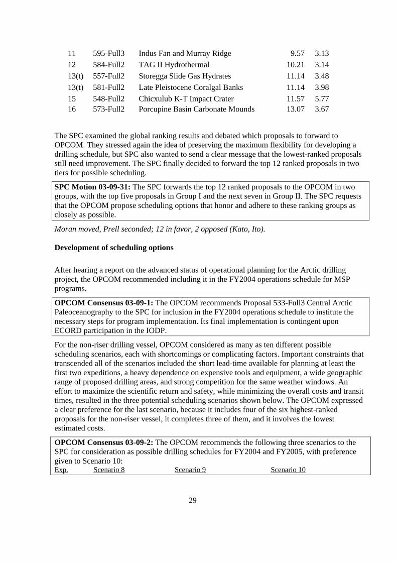
The SPC examined the global ranking results and debated which proposals to forward toOPCOM. They stressed again the idea of preserving the maximum flexibility for developing adrilling schedule, but SPC also wanted to send a clear message that the lowest-ranked proposalsstill need improvement. The SPC finally decided to forward the top 12 ranked proposals in twotiers for possible scheduling.
SPC Motion 03-09-31: The SPC forwards the top 12 ranked proposals to the OPCOM in twogroups, with the top five proposals in Group I and the next seven in Group II. The SPC requeststhat the OPCOM propose scheduling options that honor and adhere to these ranking groups asclosely as possible.
Moran moved, Prell seconded; 12 in favor, 2 opposed (Kato, Ito).
Development of scheduling options
After hearing a report on the advanced status of operational planning for the Arctic drillingproject, the OPCOM recommended including it in the FY2004 operations schedule for MSPprograms.
OPCOM Consensus 03-09-1: The OPCOM recommends Proposal 533-Full3 Central ArcticPaleoceanography to the SPC for inclusion in the FY2004 operations schedule to institute thenecessary steps for program implementation. Its final implementation is contingent uponECORD participation in the IODP.
For the non-riser drilling vessel, OPCOM considered as many as ten different possiblescheduling scenarios, each with shortcomings or complicating factors. Important constraints thattranscended all of the scenarios included the short lead-time available for planning at least thefirst two expeditions, a heavy dependence on expensive tools and equipment, a wide geographicrange of proposed drilling areas, and strong competition for the same weather windows. Aneffort to maximize the scientific return and safety, while minimizing the overall costs and transittimes, resulted in the three potential scheduling scenarios shown below. The OPCOM expresseda clear preference for the last scenario, because it includes four of the six highest-rankedproposals for the non-riser vessel, it completes three of them, and it involves the lowestestimated costs.
OPCOM Consensus 03-09-2: The OPCOM recommends the following three scenarios to theSPC for consideration as possible drilling schedules for FY2004 and FY2005, with preferencegiven to Scenario 10:Exp. Scenario 8 Scenario 9 Scenario 10

30
1 545-Full3 (Pt. 1) 545-Full3 545-Full3 (Pt. 1)2 572-Full3 (Pt. 1) 572-Full3 (Pt. 1) 572-Full3 (Pt. 1)3 584-Full2 584-Full2 512-Full3 (Pt. 1)4 512-Full3 (Pt. 1) 512-Full3 (Pt. 1) 512-Full3 (Pt. 2)5 512-Full3 (Pt. 2) 572-Full3 (Pt. 2) + 543-Full2 572-Full3 (Pt. 2) + 543-Full26 589-Full3 or 543-Full2 ----- -----Cost: $6.2-7.0M $5.6M $4.6MTransit: 42 days 52 days 52 days
Review of scheduling options and vote on final schedule
The SPC readily accepted the OPCOM recommendation on including Proposal 533-Full3 in theoperations schedule for FY2004, pending ECORD participation in IODP.
SPC Motion 03-09-32: The SPC recommends including Proposal 533-Full3 Central ArcticPaleoceanography in the MSP operations schedule for FY2004, pending ECORD participation inthe IODP.
Byrne moved, Kato seconded; 13 in favor, 1 absent (Moran).
In addition, the SPC created a project-scoping group (the Arctic Scoping Group, ASG) to satisfythe concerns of the ESO about conducting an independent technical review of the latestoperational plans for the Arctic drilling project.
SPC Consensus 03-09-33: The SPC establishes a project-scoping group to review theoperational plan for implementing Proposal 533-Full3, Central Arctic Paleoceanography. Thegroup will report to OPCOM and should include SPC member Keir Becker as the leader, SPCchair and OPCOM co-chair Mike Coffin, and several other appropriate members, such as anicebreaker captain. The group should conduct its review by late October 2003 to ensure enoughtime for including the Arctic drilling project in the annual program plan for FY2004.
The SPC then reviewed the three scheduling scenarios proposed by OPCOM for operating thenon-riser drilling vessel in FY2004 and provisionally in FY2005. SPC also preferred scenario 10for the same reasons as OPCOM, and the subsequent debate focused on developing acontingency plan in case of any difficulties in securing the use of the necessary third-party toolsfor 545-Full3, pt. 1 (now referred to as Expedition 1/300. After identifying the non-A-CORKcomponent of Proposal 553-Full2, Cascadia Margin Hydrates, as an acceptable alternate for 545-Full3, pt. 1, the SPC voted to approve the expedition schedule as follows.
SPC Motion 03-09-34: The SPC approves the following expedition schedule for the non-riservessel during June 2004 through May 2005:1. 545-Full3 Juan de Fuca Ridge Flank Hydrogeology (Part I)2. 572-Full3 N. Atlantic Neogene-Quaternary Climate (Part I)3. 512-Full3 Atlantis Oceanic Core Complex (Part I)4. 512-Full3 Atlantis Oceanic Core Complex (Part II)5a. 572-Full3 N. Atlantic Neogene-Quaternary Climate (Part II)
31
5b. 543-Full2 Norwegian Margin Bottom WaterThe SPC also identifies the non-A-CORK component of Proposal 553-Full2 Cascadia MarginHydrates as an alternate first expedition in case any significant delays arise in the logisticalplanning for Proposal 545-Full3.Prell moved, Moran seconded; 14 in favor.
Highly ranked but unscheduled proposals
Several of the other highly ranked but unscheduled proposals at the September 2003 SPCmeeting received various measures of commitment, as stated in the following motions andconsensus.
SPC Motion 03-09-36: The SPC recommends that the ECORD develop an operational plan assoon as feasible for Proposals 519-Full2, South Pacific Sea Level, and 564-Full, New JerseyShelf, in light of their respective global rankings of #1 and #4 at this meeting.Quinn moved, Moore seconded; 14 in favor.
SPC Motion 03-09-37: The SPC forwards Proposals 519-Full2, South Pacific Sea Level, 564-Full, New Jersey Shelf, and 589-Full3, Gulf of Mexico Overpressures, to the OPCOM forconsideration at the next OPCOM scheduling meeting without re-rankingKatz moved, Moore seconded; 14 in favor.
SPC Consensus 03-09-38: The SPC chair and the IMI interim program director will work withCDEX to establish an initial project-scoping group for the riser-drilling component of Proposal595 Indus Fan and Murray Ridge.
3. FY04-05 Expedition Descriptions
Based on the decisions of SPC and OPCOM, the operational schedule (Table PP-1) wasdeveloped. The field programs are shown (Figure PP-4). The schedule consists of fiveexpeditions (divided into six discrete field programs) in three oceans, the Atlantic, theArctic and the Pacific. These expeditions address all three major themes of the ISP: a) thedeep biosphere and the subseafloor ocean, b) environmental change, processes andeffects, and c) solid earth cycles and geodynamics. The Atlantic and Pacific expeditionswill use the non-riser drilling platform, whereas the Arctic expedition will involve anMSP (i.e., ice-strengthened drilling vessel) and two attending icebreakers. Detailedinformation on the five expeditions follows. (Expedition specific budgets for the non-riser expeditions are presented in Table PP-7. A glossary of expense categories followsthis table). Specific budget items for the Lomonosov Ridge expedition are presented inAppendix B.

32
Table PP-1: IODP Operational Schedule, FY04 (and provisional FY05). The convention forassigning numbers to IODP non-riser and MSP expeditions has not yet been agreed upon.
Exp. # Expedition Port (origin) Dates1,2 Total Days(Port1/Sea)
Days at Sea(Transit/Ops3)
1/300 Juan de Fuca Astoria 421 June – 29 Aug. 69 (6/63) 11/52MSP-1 Lomonosov Ridge Stavanger ~1 Aug. - ~15 Sept. TBD ~35 (in ice)
JR transit Acapulco 29 Aug. – 13 Sept. 15 (1/4) 14/02/301 North Atlantic 1 Bermuda 13 Sept. – 30 Oct. 47 (2/45) 14/313/302 CORE 1 Ponta Delgada 30 Oct. – 18 Dec. 49 (4/45) 8/374/303 CORE 2 Ponta Delgada 18 Dec. – 10 Feb. ‘05 54 (5/49) 8/415/304 N. Atl 2 & Norweg. Ponta Delgada 10 Feb. – 5 April 54 (5/49) 15/34
JR transit5 Reykjavik 5 April – 23 April 18 (3/15) 15/0
Notes:1 Ship is scheduled to arrive 0600 hr on first day of port call2 Initial expedition data reflect first day of port call; ship sails when ready3 Ops = Operations (includes both on-site and between-site time)4 Actual start date needs to be finalized5 Demobilization port is to be finalized
Figure PP-4: FY04 (and provisional FY05) expedition locations.
33
Expedition 1/300 Juan de Fuca Ridge Flank HydrogeologyProposal 545-Full3Title The hydrogeologic architecture of basaltic oceanic crust:
Compartmentalization, anisotropy, microbiology and crustal-scaleproperties on the eastern flank of Juan de Fuca Ridge
Proponents Andrew T. Fisher, Jeffrey C. Alt, Wolfgang Bach, John A. Baross, KeirBecker, Jim Cowen, Steven D’Hondt, Earl E. Davis, Michael Hutnak,David Kadko, Matthew D. McCarthy, James S. McClain, Michael J.Mottl, Martin Sinha, Glenn Spinelli, Volkhard Spiess, Damon A. H.Teagle, Heiner Villinger, C. Geoffrey Wheat, and Lars Zühlsdorff
Science DescriptionThis expedition comprises a multidisciplinary research program to evaluate the formation-scalehydrogeologic properties (transmission, storage) within oceanic crust; determine how fluidpathways are distributed within an active hydrothermal system; establish linkages among fluidcirculation, alteration and geomicrobial processes; and determine relations between seismic andhydrologic anisotropy. These goals will be accomplished through replacement of two existingsub-seafloor observatories penetrating the upper crust, and through drilling two new holes (600m and 200 m into the crust) that will be cored, sampled, instrumented and sealed. The first multi-dimensional, cross-hole experiments ever attempted in oceanic crust will be conducted, includinghydrologic, microbiological, seismic and tracer components. After completion of drill-shipoperations, multiyear tests using this network of sub-seafloor observatories will be initiated,allowing examination of a much larger volume of the crustal aquifer system than has been testedpreviously. By monitoring, sampling and testing within multiple depth intervals, scientists will:1) evaluate the extent to which oceanic crust is connected vertically and horizontally; 2) assessthe influence of these connections on fluid, solute, heat and microbiological processes; and 3)determine the importance of scaling on hydrologic properties. The study area is characterized by:a) thick sediment cover isolating permeable basement, allowing small pressure transients totravel long lateral distances, b) outstanding coverage of seismic, heat flow, coring, geochemicaland observatory data, allowing detailed hypotheses to be posed and tested, c) existing ODP drillholes and long-term observatories, providing critical monitoring points for pre- and post-drillingexperiments, d) a naturally over-pressured formation that will drive multi-year, cross-holeexperiments, and e) a planned, cabled seafloor observatory network facilitating long-termexperiments, data access and instrument control. Alternate sites are located within a shallowhydrothermal up-flow zone and in deeper basement areas where the crust is more mature. Thiswork will elucidate the nature of permeable pathways in the crust, the depth extent of circulation,the importance of permeability anisotropy, and the significance of hydrogeologic barriers in thecrust. It will demonstrate where viable microbiological communities live and how thesecommunities cycle carbon, alter rocks, and are influenced by flow paths. It will also quantifylateral scales over which solute transport occurs, the extent of flow channeling and mixing in thecrust, and how these processes relate to rock structure and fabric, and it will determine how torelate seismic velocities and velocity anisotropy to hydrogeologic properties.
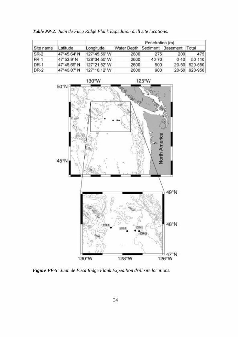
34
Table PP-2: Juan de Fuca Ridge Flank Expedition drill site locations.
Figure PP-5: Juan de Fuca Ridge Flank Expedition drill site locations.

35
Operational PlansThe highest priority objective is to complete Site SR-1 on Second Ridge in the Juan de Fucaregion (see Figure PP-5). Proposed Site SR-1 will be cored to 600 mbsf. Site SR-1 is located on3.5-Ma crust over a buried basement ridge. Experiments at this site are designed to resolve thedistribution and properties of distinct hydrothermal systems within the crust and reveal howhydrological compartmentalization relates to constructional, tectonic, alteration, microbial andseismic processes and properties.
Existing CORKs at previously instrumented ODP Sites 1026 and 1027 will be replaced. Inaddition, a new Site SR-1A will be located ~1000 m S-SW of Site 1026, where sedimentthickness is 260-275 m. A reentry cone will be installed, and continuous rotary core barrel(RCB) coring will commence. Temperature will be measured, and sediments will be sampled formicrobes and fluid chemistry, with the detailed sampling occurring near the sediment/basementinterface. RCB coring will continue 20-30 m into basement, and the hole will be reamed to allowthe installation of casing into the uppermost basement. RCB coring will continue to ~600 m intobasement. The nature and extent of alteration within the upper crust will be documented. Thehole will be logged using conventional tools (density, resistively, sonic, formation micro-scanner, borehole televiewer) to delineate fine-scale lithostratigraphy, alteration patterns andfracture distribution. Packer experiments will be run in straddle mode to evaluate near-holepermeability distribution within distinct crustal intervals, and a multi-level ACORK will beinstalled to isolate three to four crustal intervals housing independent sensors and fluid samplers.
Experiments1. Multidimensional Hydrological ExperimentsOn a yet-to-be scheduled expedition, after completing the coring programs (Sites SR-1[Expedition 1/300] and SR-2 [a future expedition]) and setting packers in basement, fluid will beinjected into a hole at Site SR-2. CORKs installed in holes at nearby Sites 1026B, 1027C andSR-1A will allow the first controlled, multidirectional, cross-hole hydrological test in oceaniccrust. Fluids will be spiked with inert tracers, allowing single-hole and cross-hole geochemicaltracer testing.2. Microbiological ExperimentsThe proposed drilling, experimental and post-drilling plan includes three stages of biological andbiogeochemical study: 1) biological sampling and analysis of the sediment column, 2) samplingand analysis of basement, and 3) time series analyses of biological communities and formationfluids. These experiments will require collection of co-located biological and pore fluid samples,and temperature measurements. Sample studies may include molecular analyses (nucleic acids,organic biomarkers), cultivation experiments and activity experiments (radiotracer, FISH).3. Borehole VSP ExperimentsThe conventional basement-logging program will be augmented with vertical and offset seismicprofile (VSP and OSP) experiments at Site SR-1. The VSP requires one or more geophonesclamped within an open or cased hole and a seismic source at the surface. These experimentswill require a three-component Array Seismic Imager and, for the vertical experiments, standardair gun or water gun sources run from the drilling ship. The offset experiments will requireseismic sources mounted on a second ship.
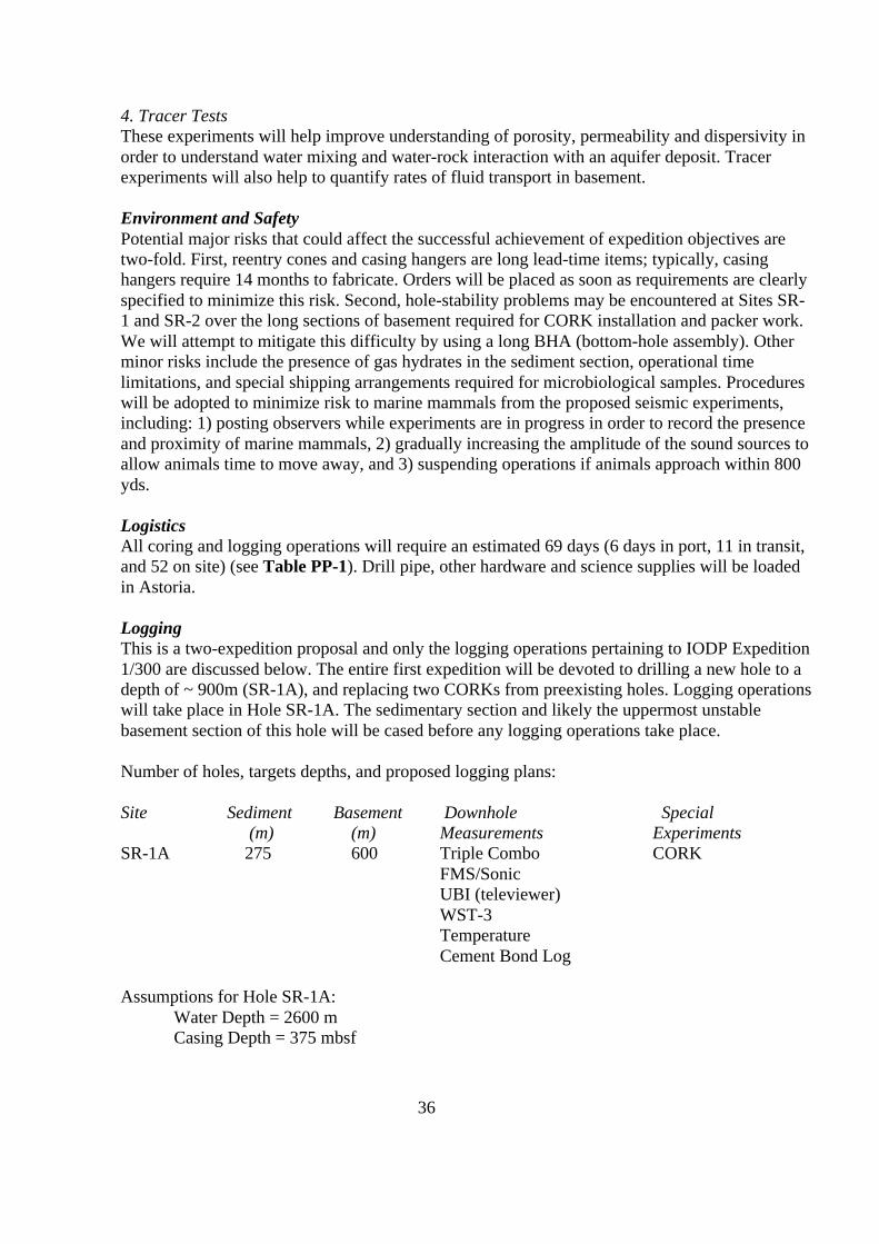
36
4. Tracer TestsThese experiments will help improve understanding of porosity, permeability and dispersivity inorder to understand water mixing and water-rock interaction with an aquifer deposit. Tracerexperiments will also help to quantify rates of fluid transport in basement.
Environment and SafetyPotential major risks that could affect the successful achievement of expedition objectives aretwo-fold. First, reentry cones and casing hangers are long lead-time items; typically, casinghangers require 14 months to fabricate. Orders will be placed as soon as requirements are clearlyspecified to minimize this risk. Second, hole-stability problems may be encountered at Sites SR-1 and SR-2 over the long sections of basement required for CORK installation and packer work.We will attempt to mitigate this difficulty by using a long BHA (bottom-hole assembly). Otherminor risks include the presence of gas hydrates in the sediment section, operational timelimitations, and special shipping arrangements required for microbiological samples. Procedureswill be adopted to minimize risk to marine mammals from the proposed seismic experiments,including: 1) posting observers while experiments are in progress in order to record the presenceand proximity of marine mammals, 2) gradually increasing the amplitude of the sound sources toallow animals time to move away, and 3) suspending operations if animals approach within 800yds.
LogisticsAll coring and logging operations will require an estimated 69 days (6 days in port, 11 in transit,and 52 on site) (see Table PP-1). Drill pipe, other hardware and science supplies will be loadedin Astoria.
LoggingThis is a two-expedition proposal and only the logging operations pertaining to IODP Expedition1/300 are discussed below. The entire first expedition will be devoted to drilling a new hole to adepth of ~ 900m (SR-1A), and replacing two CORKs from preexisting holes. Logging operationswill take place in Hole SR-1A. The sedimentary section and likely the uppermost unstablebasement section of this hole will be cased before any logging operations take place.
Number of holes, targets depths, and proposed logging plans:
Site Sediment Basement Downhole Special (m) (m) Measurements Experiments
SR-1A 275 600 Triple Combo CORKFMS/SonicUBI (televiewer)WST-3TemperatureCement Bond Log
Assumptions for Hole SR-1A:Water Depth = 2600 mCasing Depth = 375 mbsf

37
Hole Depth = 900 mbsfOpen Hole Interval Logged = 525 m
The wireline logging program will consist of four deployments (funding for the UBI deploymentis pending). A thermistor will be placed on the cable head to allow us to monitor and recordborehole temperatures in real time, similar to the procedure used during ODP Leg 193. This willgive advance warning if (high) temperatures become a problem for the wireline tools; thermistorreadings can also be used as a “rough” temperature log. The estimated total time required forlogging is ~37 hrs, with longer times needed for increased resolution of the televiewer data.
Expedition MSP-1 Central Arctic PaleoceanographyProposal 533-Full3Title Paleoceanographic and tectonic evolution of the central Arctic OceanProponents Jan Backman, Nikita Bogdanov, Bernard Coakley, Margo Edwards,
Rene Forsberg, Ruth Jackson, Martin Jakobsson, Wilfried Jokat,Yngve Kristoffersen, Larry Mayer, Kathryn Moran
Science DescriptionFive drill sites lie on the ridge crest of the Lomonosov Ridge in the central Arctic Ocean.They are distributed between 81°N and 88°N, in water depths ranging between 800 and1415 m. All are located in international waters. The Lomonosov Ridge was rifted from theshelf in the Kara and Barents Sea during early Paleogene time and subsequently subsided toits present water depth. Sediments of biogenic, eolian and ice-rafted origins have sinceaccumulated on the ridge crest. In the primary target area between 87°N and 88°N, this~flat-lying sediment cap is ~450 m thick, indicating an average sedimentation rate of ~10m/m.y. throughout the course of the Cenozoic. Sampling of this presumed pelagic sedimentcap will provide an unprecedented and unique opportunity to acquire first-order knowledgeabout the paleoceanographic history of the central Arctic Ocean. Sampling of the underlyingbedrock beneath a pronounced angular (seismic) unconformity provides a similarly uniqueopportunity to decipher the tectonic history of the Lomonosov Ridge and the formation ofthe Eurasian Basin. Scientific objectives are to investigate: a) the long-term (50 Ma) climatehistory of the central Arctic Ocean and its role in the transition from one global climateextreme (Paleogene greenhouse, lacking glaciation) to another (Neogene icehouse,exhibiting bipolar glaciation), b) the shorter-term (Neogene) climate history, connecting theNeogene history of the Arctic Ocean to that of the North Atlantic Ocean at sub-millennialscale resolution, c) the composition and origin of presumed pre-Cenozoic bedrockunderlying the sediment cap, and d) the rifting and subsidence history of the LomonosovRidge. The widely spaced latitude and partially overlapping goals of the five drill sites willmake the overall expedition less vulnerable to severe local ice conditions. The major goalsof this proposal can be achieved by completing one site (i.e., by means of multiplepenetrations, if necessary and as required) to ~450 mbsf, the base of the presumed pelagiccap. If ice conditions prohibit success at this site, a suite of sites from other areas along theLomonosov Ridge corridor will be drilled to achieve the proposed science.

38
Table PP-3: Central Arctic paleoceanography expedition drill site locations.
Figure PP-6: Central Arctic paleoceanography expedition drill site locations.
Operational Plans (for additional details, see Appendix B.)
FleetThe proposed fleet for the Lomonsov Ridge project comprises three vessels:
39
• The icebreaker/drillship Vidar Viking• Close-support icebreaker Oden• A large Russian icebreaker, probably the (non-nuclear) Krasin
(As of November 7, it must be stressed that, with the exception of Oden, these arepreferred vessels and that detailed contract negotiations, in particular for Vidar Vikingand Krasin, have yet to be completed.)
The large Russian icebreaker will be either the conventionally powered Krasin or anuclear powered vessel (NIB) based in Murmansk. ESO stresses that a nuclear poweredvessel is not essential to the expedition, and indeed it may be argued that the use of anuclear icebreaker would be damaging to the image of the expedition, and could befraught with contractual difficulties related to environmental protection and liability inthe case of any accident involving the nuclear icebreaker. To date, ESO has had littleinformation from the owners of the nuclear vessel, whereas a deputation is to visit theKrasin and its owners in Vladivostok during November 2003. It seems most likely thatthe Krasin will be contracted; the Krasin is the only Russian vessel for which ESO hasreceived a detailed quotation. All coring operations will be conducted from thedynamically positioned Vidar Viking with the Oden in close support. The Krasin/NIBwill operate some distance upsteam, breaking ice as it drifts towards the drilling location.The Oden will break the ice further and divert it as it approaches the drillship, allowingthe latter to maintain station in relatively clear water, or without significant ice pressureas the ice drifts past it. The Oden will act as the command and communication center andwill carry the Fleet Manager, the ice management team, most of the science team, andwill be the base for helicopter operations. The three vessels will either transit togetherthrough the pack ice to and from the working area, with Krasin/NIB and Oden escortingthe Vidar Viking, or the Krasin will sail directly from Vladivostok to the chosen drill site.The latter may be cost-effective in view of the substantial cost of the Krasin steamingfrom Vladivostok to Tromsø or the ‘Atlantic’ ice edge, whereas the route fromVladivostok direct to the drill sites is relatively small. This decision will be dependent onthe eventual contracted agreement and costs.
CoringCoring in the Arctic in water depths of ~1000 m requires the use of a robust and flexibledrill-string, coupled to a strong and compatible BHA able to withstand a limited amountof lateral movement in the water column and sudden lateral movements, which will occurdue to passing ice and thus affect both the drill-string and the drilling vessel. Thisrequires the use of an oilfield-type API drill-string (preferably 5” drill-pipe and 7” OD x4” ID drill collars, both with 5” FH connections), and an API-compatible core-barrelassembly. An element of protection to the drill-string in the area below the moonpool isalso required; observation of the ship-model test results indicates that this can beachieved with a 2 m extended skirt, which will be deployed through the moonpool priorto the start of drilling operations.
The science plan calls for extensive use of a piston corer similar to that currently used byODP (i.e., the Advanced Piston Corer or APC), in order to obtain as much high-quality

40
core recovery as possible in the presumed soft sediment environment of the pelagic cap.Such a facility also needs to be compatible with other coring methods, in order that anystratigraphic formations encountered can be cored as well as possible. Unfortunately, thewell-tried and proved ODP core barrel equipment cannot be used, as the derrick capacityavailable is not suitable for handling the tool lengths used in ODP. The Vidar Viking willhave the capacity to handle only single pipe lengths. Research has been carried out to findthe core barrel required to meet these requirements. Two systems have been considered indetail:
• The QD TECH/DOSECC system currently used for lake drilling in shallow water,which uses a mining drill-string.
• The BGS Marine Wireline Corebarrel system, which is based on API oilfieldtubulars.
Neither system is immediately suitable without modifications. We propose to use amodified version of the existing BGS Marine Wireline Corebarrel System, with theincorporation of a 4.5-m piston corer to be built according to the ODP APC design.Discussion has taken place with Stress Engineering Services, Inc. in Houston and ROKMAX UK, Ltd (who design and build the BGS equipment) regarding design issues andmodification implications. The modifications and their incorporation into a combined androbust set of coring tools are feasible and have begun. The system will be bench- andfield-tested prior to any actual operation (see the Arctic Scoping Group report, availablefrom the SAS Office); OPCOM will be kept informed as tool development proceeds.
Seacore, an over-water drilling contractor with extensive experience and high-calibrepersonnel, has been selected as the preferred drilling contractor. Seacore has installedmodular drilling rigs on a number of vessels for geotechnical coring work and hasoperated with BGS and their equipment for both scientific and commercial work,including the Ormen Lange Gas Field for Norsk Hydro/Statoil. The work at OrmenLange is believed to be very similar in water/hole depths and anticipated geologicalformation to that at Lomonosov Ridge. A modular drilling rig (C200 Model), with Wirthor similar top drive of sufficient lifting capacity, will be installed for coring operations.Drilling tubulars will be to API standard, with up-to-date thread and crack inspections;they will comprise 7” OD x 4” ID drill collars and 5” API Range 2 drill-pipe, both with5” FH connections. The drill-pipe tool joints also will have a minimum 4” ID. Sub-zeromodification is required for this project and will be implemented. The rig comescomplete with pipe rack, pipe handling, power packs, mud tanks and all accessories andspares. Bio-degradeable polymer mud of the cellulose variety will be used while drilling.
LogisticsThe estimate for total time for Expedition MSP-1 is yet to be determined, but the scienceobjectives require ~35 days in the ice. This expedition will take place in August-September 2004 (see Table PP-1).
LoggingThe Lomonosov Ridge Project, as will be the case for all MSP operations, presents somespecific challenges for downhole logging operations. The overarching approach beingapplied by the European Petrophysics Consortium towards downhole logging for this
41
expedition is flexibility. Under the most favorable conditions, it may be possible to stayon-site for the duration of all operations, which would facilitate data acquisition bywireline logging. However, we consider it more likely that ice conditions will requireperiodic hole abandonment, thus precluding wireline logging. Under these circumstances,in order to maximize the data collected in any single hole, a tool-string will be deployedthrough the BHA, logging formation properties in memory mode, as pipe is tripped toclear the seafloor. We anticipate that most, if not all, of the Lomonsov Ridge holes can belogged in this manner, providing a robust method of hole-to-hole correlation and atemplate for core-splicing and stratigraphic correlation. Using combined memory modeand wireline downhole logging, downhole logging and core data can then be integrated toprovide a means of continuous sampling of the cored stratigraphy at all sites.
The following is a generic list of minimum and additional tools based on formationproperties and not ‘operator’-based trademark names:
Minimum measurements1. Borehole diameter - for quality control and borehole corrections.2. Natural gamma (total counts and spectral) – for log-log and core-log correlation
(total counts), clay typing, mineralogy and ash-layer detection (spectral).3. Porosity (this may require a radioactive source) – for physical properties, core-log
correlation, quality control, lithology, etc.4. Electrical resistivity (shallow-deep measurement) – multiple usages, a robust
measurement even under poor borehole conditions.5. Density (this may require a radioactive source) – for physical properties, core-log
correlation, borehole-seismic integration, lithology/geochemistry, etc.6. Temperature – for heat flow and hydrogeology.7. Sonic measurements – for core-log correlation, borehole-seismic integration,
quality control etc.Additional measurements (should be viewed as preferred, along with 1-7 above)8. High-resolution borehole imaging (electrical, acoustic and/or optical) – for core-
log correlation, cyclostratigraphic analyses, oriented sedimentological andstructural information.
9. Check-shot – direct measurement of acoustic travel time for core/borehole-seismic integration.
We envisage that all the above (including the check-shot - conditions permitting) will beemployed on the Lomonosov Ridge.

42
Expeditions 2/301 + 5/304 North Atlantic Neogene-Quaternary EnvironmentsProposal 572-Full3Title Ice-sheet–ocean–atmosphere interactions on millennial time
scales during the late Neogene–Quaternary using apaleointensity-assisted chronology for the N. Atlantic
Proponents James E. T. Channell, Joseph S. Stoner, Gerard C. Bond,David A. Hodell and Ellen E. Martin
Science Description (Note: This science program will be undertaken in two parts, asexpeditions 2/301 and 5/304, see Figure ES-5a.; operations and logging for expedition 5/304will be discussed in more detail as part of the FY05 Program Plan.)This expedition involves drilling late Neogene to Quaternary age sediments at nine sites inthe North Atlantic Ocean. Previous drilling and piston coring results indicate that theproposed drill sites: a) contain distinct records of millennial-scale environmental variabilityin terms of ice-sheet–ocean interactions, deep circulation changes and sea-surface conditions,b) provide the requirements for developing a millennial-scale stratigraphy throughgeomagnetic paleointensity, oxygen isotopes and regional environmental patterns, and c)document the details of geomagnetic field behavior. The objectives are to intercalibrate thegeomagnetic paleointensity records, isotope stratigraphies and regional environmentalstratigraphies, and thereby develop a millennial-scale stratigraphic template for the past fewmillion years. Such a template is required for understanding the relative phasing ofatmospheric, cryospheric and oceanic changes that are central to our understanding of themechanisms of global climate change on orbital to millennial time scales. In addition, thehigh-resolution records of directional, secular variation and geomagnetic paleointensity willgreatly improve our knowledge of the temporal and spatial behavior of the geomagneticfield, as well as provide fundamental constraints for numerical models of the geodynamo.The drill sites are located in the Labrador Sea, the Irminger Basin, on the Eirik Drift offOrphan Knoll, on the southern part of the Gardar Drift and at DSDP Site 607/609. (Only theLabrador Sea, Irminger Sea and Eirik Drift sites will be addressed in FY04.) These sitespreserve components of ice-sheet–ocean interactions, with potential for chronologicalcontrol through stable isotopes and geomagnetic paleointensity. Some are located within theNorth Atlantic belt of ice-rafted debris, between previous drilling sites to the north (60 to77˚N; ODP Leg 162) and south (30 to 35˚N; ODP Leg 172). The proposed sites also lie inan appropriate bathymetric depth range (2750 to 3719 m) for detecting millennial-scalechanges in the formation of deep and intermediate water masses.
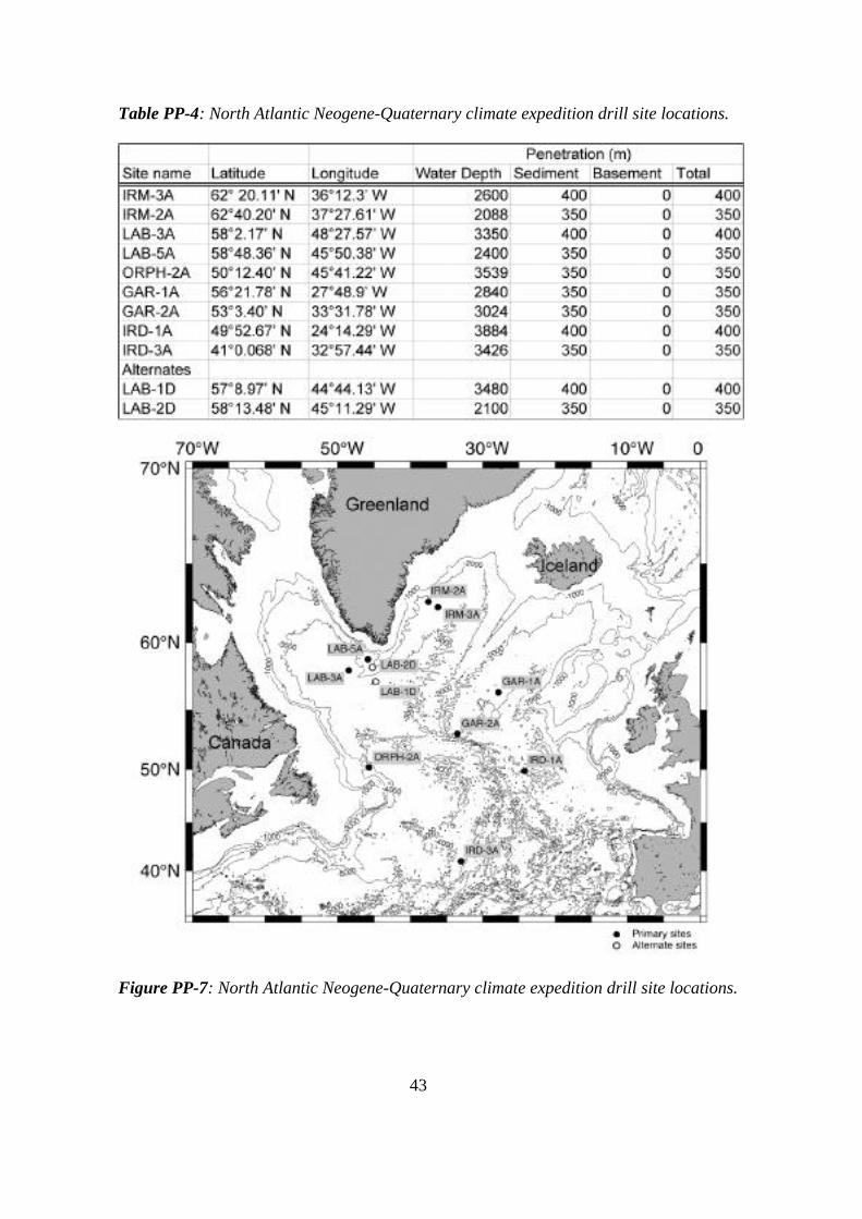
43
Table PP-4: North Atlantic Neogene-Quaternary climate expedition drill site locations.
Figure PP-7: North Atlantic Neogene-Quaternary climate expedition drill site locations.

44
Operational PlansBoth expeditions will involve routine sediment coring. Each site will be quadruple APC cored toassure recovery of the complete sediment section. APC coring will extend to ~150 m belowseafloor. One hole at each site will be deepened to 350–400 m for logging purposes.
Environment and SafetyThere is a high risk of losing operating time as a result of severe weather and ice conditions. Theoptimum weather window for drilling these sites is July through September. Given thescheduling constraints for FY04, scheduling this expedition in the September to October timeframe is unavoidable (see Table PP-1). This increases the risk of operational downtime as aresult of adverse weather to ~10%. To minimize safety risks to personnel and equipment, we willarrange for daily site-specific forecasts from a weather service experienced in North Atlanticconditions. Three additional operating days have been added to this program to accommodateoperating time lost because of weather. The risk of encountering poor hole conditions is low.
LogisticsOperations for Expedition 2/301 will require an estimated 47 days (2 days in port, 14 in transit,and 31 on site [2 days in port, 7 in transit, and 8 on site in FY04]).
LoggingDuring Expedition 2/301, two sites (see table below) will be logged both with the standardgeophysical tool string for density, porosity, resistivity and gamma ray information and theFMS/Sonic tool string for high resolution resistivity logs and images and sonic velocity data.Total logging time is ~38 hrs. Data generated will be critical for hole-to-hole correlation, core-log integration and hole-to-seismic correlation, and correlation of results from Expeditions 2/301and 5/304. Furthermore, given sufficient sedimentation rates, it should be possible to investigatecyclostratigraphy using the downhole geophysical data. Successful core-log integration will alsobe necessary to determine the completeness of the recovered section and thereby assess theaccuracy of the stratigraphic framework. (Note: Costs for Expedition 2/301 and 5/304 loggingoperations will be incurred in FY05, and therefore are not included in the FY04 Program Planbudget.)
Site Water depth (mbsl) Hole depth (mbsf) Logging operationsIRM3A 2600 400 Standard, FMS/sonicLAB3A 3350 400 Standard, FMS/sonic
Expeditions 3/302 + 4/303 Atlantis Oceanic Core ComplexProposal 512-Full3Title Oceanic core complex formation: Deformation, alteration,
and accessible mantle peridotiteProponents Donna Blackman, John Collins, Javier Escartin, G. Früh-
Green, Kevin Johnson, Chris MacLeod, Monique Seyler
Science DescriptionThe primary objective of Expeditions 3/302 and 4/303 is to document the conditions underwhich oceanic core complexes develop. Domal massifs capped by corrugated, striated
45
detachment faults have been mapped at several locations on the seafloor. These large,shallow seafloor features apparently form as a result of episodic plate rifting and accretion atslow spreading ridges. However, currently available data are insufficient to characterize themagmatic, tectonic and metamorphic history of oceanic core complexes, and understand themechanisms of their uplift and emplacement. The first goal is to drill one hole through thebasaltic hanging wall of Atlantis Massif, in order to sample rock just above the detachment,the shallowest part of the unexposed fault, and through a portion of the fault zone. A secondgoal is to characterize the nature of the alteration front within oceanic peridotite. Oceaniccore complexes expose altered upper mantle peridotites and mafic crustal rocks. Thealteration of these rocks and the process of serpentinization greatly affect the geophysicalproperties of the lithosphere. Mantle seismic velocities have been measured at depths asshallow as several hundred meters on the central dome of the massif; therefore, drilling atAtlantis Massif offers an unprecedented opportunity to determine the nature of the Moho. Isit a hydration front rather than the crust–mantle boundary? The potential for recovering freshperidotite at Atlantis Massif presents excellent opportunities for advances in understandingresidual modes and microstructure within the oceanic mantle. Cores of essentially fresh, in-situ peridotite will allow documentation of composition, microstructure, evidence for meltproduction and migration, and relationships among deformation, melt and syntectonicalteration. Drilling a second, deep hole on the central dome of Atlantis Massif will: 1) allowsampling of the detachment fault zone and the alteration front, and 2) penetrate and recoverunaltered mantle.

46
Table PP-5: Atlantis oceanic core complex expedition drill site locations.
Figure PP-8: Atlantis oceanic core complex expedition drill site locations.
Operational Plans and ExperimentsBoth sites will require casing into basement in order to maximize the chances ofachieving deep penetration. The first casing string will be set in basement, using the

47
HRRS Hammer Drill-in Casing system. Each site will then be RCB-cored to ~130 m,then opened using a bi-centered bit and underreamer, which will allow a second casingstring to be set. Next, each hole will be RCB- cored to maximum depth.This is a two-expedition program. (Note: The second expedition, 5/304 [see Table PP-1],will occur in FY05 and therefore will be discussed in more detail as part of the FY05Program Plan.) During Expedition 3/302, both sites will be drilled to casing depth andcasing will be set. The remaining time will be devoted to drilling and coring the (first)deep hole as deeply as possible. The second expedition will be devoted to deepening bothholes.
Environment and SafetyThe principal risks to this program are the difficulty of starting a hole on bare rock andthe possibility of encountering unstable hole conditions. The difficulty of starting a holeon bare rock will be mitigated via use of the HRRS Hammer Drill-in-Casing system.Experience has shown that in hard rock drilling, the upper part of the hole is most proneto instability; hence, the upper 120 m of each hole will be cased off. Below that sub-seafloor depth, we expect to encounter more competent rock that will provide stableconditions and thereby allow deep penetration. The shallower (hanging wall) site mayexhibit unstable hole conditions throughout. Sufficient supplies and hardware will becarried to allow a third hole to be started, in the event that one of the primary holes is lostthrough instability. Weather conditions should not be a limiting factor, even though thisexpedition is scheduled for late fall 2004 (see Table PP-1). Procedures will be adopted tominimize risk to marine mammals from the proposed seismic experiments, including 1)posting observers while experiments are in progress to record the presence and proximityof marine mammals, 2) gradually increasing the amplitude of the sound sources to allowanimals time to move away, and 3) suspending operations if animals approach within 800yds.
LogisticsOperations for Expedition 3/302 will require an estimated 49 days (4 days in port, 8 intransit, and 37 on site) (see Table PP-1).
LoggingThe tectonic and structural objectives will particularly benefit from logging data.Recording of in situ physical properties data is essential to core-log integration studiesand a continuous lithological and acoustic characterization of penetrated structures,allowing the linkage of seismic velocity, lithology and degree of alteration, as well as thedistribution of fractures at each site. High-resolution (cm-scale) image data will providean accurate description of tectonic and structural features. Standard geophysical logsshould be run for each hole, including a VSP, as well as the Formation MicroScanner(FMS) and the Ultrasonic Borehole Imager (UBI) (as outlined in the table below).Collecting standard logs and VSP information during Expedition 3/302 will provideaccurate calibration of the sites to available seismic surveys (limited amounts of legacydata are available at this location). Prior to completion of the drilling and loggingprogram, two-ship offset VSP experiments will be conducted during Expedition 4/303.All VSP experiments will occur pending environmental clearances. (Note: Costs for both
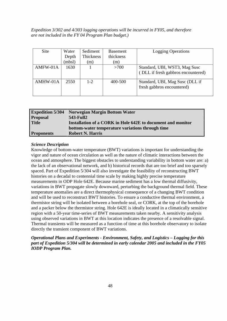
48
Expedition 3/302 and 4/303 logging operations will be incurred in FY05, and thereforeare not included in the FY 04 Program Plan budget.)
Site Water Depth(mbsl)
SedimentThickness (m)
Basement thickness (m)
Logging Operations
AMFW-01A 1630 1 >700 Standard, UBI, WST3, Mag Susc( DLL if fresh gabbros encountered)
AMHW-01A 2550 1-2 400-500 Standard, UBI, Mag Susc (DLL iffresh gabbros encountered)
Expedition 5/304 Norwegian Margin Bottom WaterProposal 543-Full2Title Installation of a CORK in Hole 642E to document and monitor
bottom-water temperature variations through timeProponents Robert N. Harris
Science DescriptionKnowledge of bottom-water temperature (BWT) variations is important for understanding thevigor and nature of ocean circulation as well as the nature of climatic interactions between theocean and atmosphere. The biggest obstacles to understanding variability in bottom water are: a)the lack of an observational network, and b) historical records that are too brief and too sparselyspaced. Part of Expedition 5/304 will also investigate the feasibility of reconstructing BWThistories on a decadal to centennial time scale by making highly precise temperaturemeasurements in ODP Hole 642E. Because marine sediment has a low thermal diffusivity,variations in BWT propagate slowly downward, perturbing the background thermal field. Thesetemperature anomalies are a direct thermophysical consequence of a changing BWT conditionand will be used to reconstruct BWT histories. To ensure a conductive thermal environment, athermistor string will be isolated between a borehole seal, or CORK, at the top of the boreholeand a packer below the thermistor string. Hole 642E is ideally located in a climatically sensitiveregion with a 50-year time-series of BWT measurements taken nearby. A sensitivity analysisusing observed variations in BWT at this location indicates the presence of a resolvable signal.Thermal transients will be measured as a function of time at this borehole observatory to isolatedirectly the transient component of BWT variations.
Operational Plans and Experiments - Environment, Safety, and Logistics – Logging for thispart of Expedition 5/304 will be determined in early calendar 2005 and included in the FY05IODP Program Plan.

49
Table PP-6: Norwegian Margin bottom water expedition drill site location.
Figure PP-9: Norwegian Margin bottom water expedition drill site location.
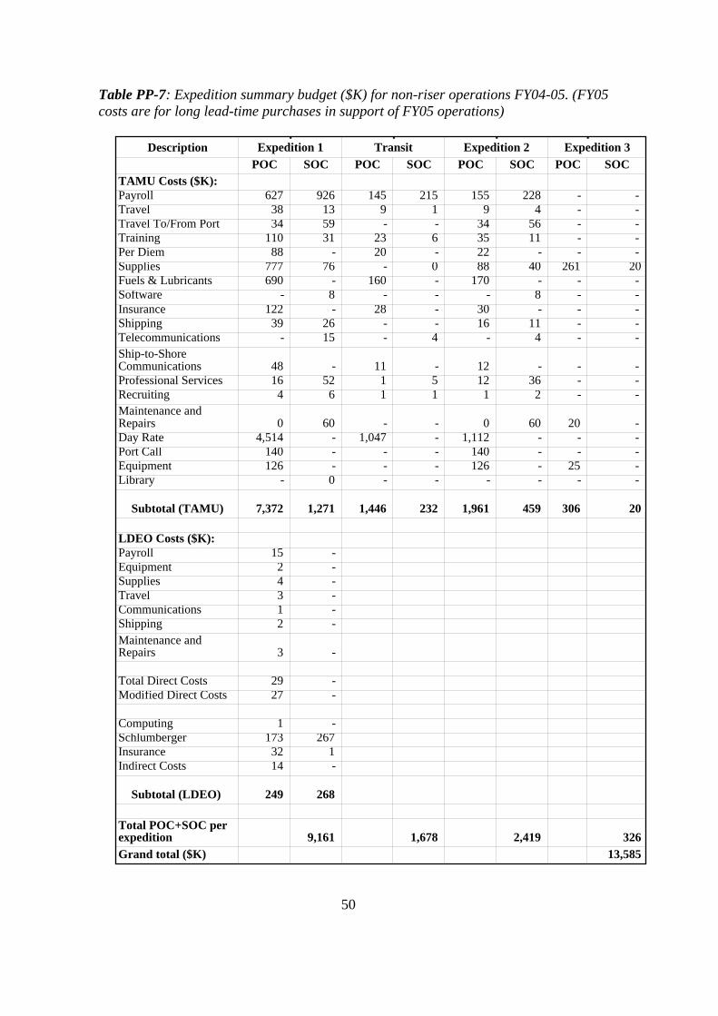
50
Table PP-7: Expedition summary budget ($K) for non-riser operations FY04-05. (FY05costs are for long lead-time purchases in support of FY05 operations)
DescriptionPOC SOC POC SOC POC SOC POC SOC
TAMU Costs ($K):Payroll 627 926 145 215 155 228 - - Travel 38 13 9 1 9 4 - - Travel To/From Port 34 59 - - 34 56 - - Training 110 31 23 6 35 11 - - Per Diem 88 - 20 - 22 - - - Supplies 777 76 - 0 88 40 261 20 Fuels & Lubricants 690 - 160 - 170 - - - Software - 8 - - - 8 - - Insurance 122 - 28 - 30 - - - Shipping 39 26 - - 16 11 - - Telecommunications - 15 - 4 - 4 - - Ship-to-Shore Communications 48 - 11 - 12 - - - Professional Services 16 52 1 5 12 36 - - Recruiting 4 6 1 1 1 2 - - Maintenance and Repairs 0 60 - - 0 60 20 - Day Rate 4,514 - 1,047 - 1,112 - - - Port Call 140 - - - 140 - - - Equipment 126 - - - 126 - 25 - Library - 0 - - - - - -
Subtotal (TAMU) 7,372 1,271 1,446 232 1,961 459 306 20
LDEO Costs ($K):Payroll 15 - Equipment 2 - Supplies 4 - Travel 3 - Communications 1 - Shipping 2 - Maintenance and Repairs 3 -
Total Direct Costs 29 - Modified Direct Costs 27 -
Computing 1 - Schlumberger 173 267 Insurance 32 1 Indirect Costs 14 -
Subtotal (LDEO) 249 268
Total POC+SOC per expedition 9,161 1,678 2,419 326 Grand total ($K) 13,585
Expedition 1 Transit Expedition 2 Expedition 3

51
Glossary of Expense Categories – Expeditions
TAMU Costs
Payroll—This category contains salary, fringe, and sea pay directly associated with specificexpeditions, along with pro rata amounts of the same items for employee efforts in support ofexpedition activities.Travel—Travel in support of expedition activities (e.g., post-expedition travel), exclusive of portcall travel, are contained in this expense category.Travel to/from Port—Funds in this category support travel to and from the ship at port calls forall seagoing personnel and other Program employees attending port call. All funds areexpedition-specific.Training—This category contains funds that support training of the shipboard staff and otherProgram employees who receive specific training (e.g., Labview, Novell, etc.) that supportsshipboard activities. The costs are both expedition-specific and pro rata.Per Diem—This category reflects catering charges for 45 personnel per month based on the mostrecent averages of shipboard participants. This category does not include ODL, SOS or Catermarpersonnel, as they are accounted for in the day rate.Supplies—In this category are expedition-specific supplies (e.g., drilling supplies, laboratorysupplies, core liners, etc.), safety equipment for the ship and personnel and departmental pro rataexpenses associated with the annual cost of supporting the science plan at sea.Fuel & Lubricants—Fuel and lubricants are budgeted for refuelings at an average cost permetric ton and associated costs.Software—Funds used to support upgrades to existing software.Insurance (Ship Ops-ODL/ODP)—Funds in these categories are to reimburse ODL for Hull &Machinery and Removal of Wreck coverage and the ODP/TAMRF Marine Package insurance(refer to Appendix III).Shipping—The majority of costs contained in this category are expedition-specific costs andinvolve shipment of equipment and supplies to and from the ship. There is a small amount offunds associated with shipment/mailing of items in support of expedition activities throughoutthe year.Telecommunications—This expense is associated with shore-based cost incurred in support ofexpedition activities. Some costs are expedition-specific, while others are incurred in support ofmultiple expeditions.Ship-to-Shore Communications—Satellite and regular communications charges between theJOIDES Resolution and shore-based personnel are included in this category.Professional Services—In this category are costs associated with temporary employees hiredthrough companies/corporations, drill pipe maintenance, wireline severing charges, shipboardmaintenance service calls, transfer fees, weather reports, and physical examinations for seagoingpersonnel.Recruiting—Funds for recruitment of seagoing personnel.Maintenance and Repairs—Funds contained in this category are for repairing drilling, coring,operations, and laboratory equipment for the ship.Day Rates—Covers the cost of staffing the ship to include the sailing crew, drilling personnel,and catering personnel. It does not cover the cost of TAMU’s crew or the scientists on board the

52
ship. The day rate varies according to the mode of the ship that is generally operating, standby,or cruising. While it is a fixed rate per day, the day rate is adjusted for changes in the ConsumerPrice Index-Urban (CPI-U) and Employment Cost Index (ECI). When the cumulative change inthe CPI-U and ECI (since the last increase) equals or exceeds 2%, the day rates will be adjustedby the percentage change. The adjustment takes effect at the beginning of the month followingthe increase and cannot occur more frequently than every six months.Port Calls—Locations have a definite effect on the cost of port calls that covers agents’ expensesand freight associated with resupplying the ship. During each port call, cores and equipment areoff-loaded from the previous expedition and supplies are loaded for the upcoming expedition.ODL is reimbursed for port agent charges and the shipment of food and related supplies.Shipment of cores, drilling equipment, and laboratory supplies is arranged and paid by TAMUand paid for by TAMRF. Similarly, TAMRF purchases all drilling equipment and laboratorysupplies necessary for meeting the objectives of the expedition. These costs are covered in otherareas, not Ship Operations.Equipment—Includes costs associated directly with equipment (computer, scientific, anddrilling) intended solely for use on the ship over a period of time greater than one expedition,equipment purchased for a specific expedition and pro-rata cost of shore-based equipment usedpartially to support expedition activities.Library—Funds for books, journals and other scientific resources.
LDEO Costs
Payroll—Expedition-based salaries include fringe and sea pay for logging scientists during theexpedition. Salaries for pre- and post-expedition work are not included. Salaries for shore-basedprocessing and other technical support are also not included.Equipment—Prorated costs of computer, scientific, and engineering equipment for use on theship over a period of time greater than one expedition.Supplies—The cost of replenishing supplies for the Downhole Measurements Lab and forupgrades/additions to the software for this lab.Travel—Travel of sea-going personnel to and from the drillship. It does not cover pre- and post-expedition travel associated with the expedition (e.g., pre-expedition meetings).Communications— The costs for phone and fax communication to the ship, as well as satellitetransmission of data.Shipping—The costs for routine shipments to and from the ship.Maintenance and Repairs— Upgrade, modifications, and repair of non-Schlumberger tools anddata acquisition systems.Computing—The LDEO Computer Group provides computer maintenance, system backup, andInternet access. Repair, upgrade, and backup of Sun Microsystems hardware and software will becovered under the LDEO network subscription. Calculations for this category are based on acharge of 3% of the Modified Direct Costs.Schlumberger—Covers the costs associated with the leasing of standard tools and the associatedengineering support services. POC costs are for equipment needed for back-off and severingservices, including the Schlumberger engineer day rate.Insurance—Insurance for standard and specialty logging tools during below-the-keeldeployments. POC costs are for equipment needed for back-off and severing services.

53
Indirect Costs— Indirect costs (53%) are assessed on all charges except permanent equipment,tuition remissions, LDEO computer services, and downhole tool insurance.
4. FY04 Budget Overview
This Program Plan budget identifies a total program cost of $40,014 K for FY04 (see Table PP-8), the inaugural year of the IODP, to meet the high-priority needs identified by the SAS. Of thiscost, 38% is considered to be Science Operation Costs (SOCs) and the remaining 62% isPlatform Operation Costs (POCs). These costs are distributed among the three IOs and IMI.
IMI’s budget is not yet available in details because it is currently subject to negotiation betweenNSF and IMI. An approximate figure of $2 M is provided, and this excludes the cost of severalactivities and services, such as databases, core repositories, engineering development and supportfor the SAS and SAO offices, as well as for a site survey data bank. Note that NSF, through JOI,is providing support for the data bank in FY04 via the ODP contract.
The JOI Alliance budget of $22,121 K for FY04 includes support for the final transit of theJOIDES Resolution, one full expedition (Juan de Fuca), partial support for the second expedition(North Atlantic 1) that bridges over into FY05, and approximately $326K for the third expedition(CORE 1) that will be conducted in FY2005. Of the Alliance’s total budget, 61% is directlyaffiliated with the final transit and operations (see Table PP-7).
Of the total ESO budget of $12,493 K, 78% ($9,738) is allocated to POCs, primarily in supportof the Arctic expedition. Other funds are in support of long-term planning, maintenance andonshore activities.
Of the total CDEX budget of $3,400 K, $318 K will go towards science services, and theremainder ($3,082 K) will be used for site survey needs.
Budget Process
After the IODP scientific needs for FY04 were identified, the budget process began bydetermining the expedition-based scientific and operational requirements, including the operatingcosts of vessels, drilling and down-hole operations, logging science, and laboratory needs,among others. Most funds within the science and logging operational budgets have beenallocated to, and apportioned within, leg-based budgets. Detailed budgets for the non-riserexpeditions in FY04 are presented in the previous section. Similar detail for the MSP expeditionis provided in Appendix B. Note that resources are requested in this Plan for items or servicesaffiliated with FY05 expeditions that require long lead-time purchases or commitments.
The second step in the budget process is assessing program needs that are not directly affiliatedwith FY04 expeditions, such as services in science, technical support, operations, publications,information, management, administration, logging, SAS/SAO advisory, site assessment, publicaffairs and technical development projects. Some of these funds will become part of the IMIbudget that is currently under negotiation. The remainder is incorporated into the IO budgetspresented in the appendices.

54
The third step in the process is determining whether an expense is a POC or a SOC. These costsare defined, at least at an overarching level, in the IODP memorandum between the US andJapan. Refinements of these definitions are ongoing, subject to approval by the Agencies.
Table PP-8: IODP summary budget for FY04 ($K).
Entity Specifics SOCs POCs Total ($K)IMI TOTAL * 2,000$ -$ 2,000$
JOI AllianceJOI 730$ 1,080$ 1,810$ TAMU 6,889$ 10,438$ 17,327$ LDEO 2,367$ 618$ 2,984$ TOTAL 9,986$ 12,136$ 22,121$
ESOPlanning & maintenance 694$ 25$ 719$ Arctic expedition 2,061$ 9,713$ 11,774$ TOTAL ** 2,755$ 9,738$ 12,493$
CDEX TOTAL 318$ 3,082$ 3,400$
Grand TOTAL 15,059$ 24,956$ 40,014$
* Excludes subcontracts for database, repositories, and engin. dev.SAS/SAO office costs are included, but amounts are not specified.NSF ODP funds, through JOI, will support the data bank in FY04. IMI will beresponsible for providing data bank services in FY05 and beyond.** Excludes the commingled SOCs contribution to the EMA office.