glacial map of ohio · pdf fileto as the pleistocene epoch or, ... the edge of the glacier,...
TRANSCRIPT
�
�
�� �� �� ������
�� �� �� �� ����������
���������������
����������������
�������
������������
����
������
�������������
���!���"������������
�������������
���!���"������������
#����!�$�������
�������������
%���&�����"������������
'�"��������
������������� ������� �����������
���������� � ����� � �����������
�������������������� �!�� � �������
%(��()*+ ,-�.�/ �-�)+
�..)%)
%�� #0/'1
0,()/�0
#)' (/
#)/����
)-��)(20
)��0/
�-./)*
*0'�0'
3)/�%0'.
�)-� (/�
#��*0+
0'(0+)/ -+�1
+0/0�)#-'�/
��')(/
*0 (/)
%)1/0)+#�)/ '(�#�)/ �')%,�'
*�''�%
%1)/ �.
*)'(�/�)''���
+.)'� ���-*4()/)
*)#�/(/�
.'-*4-��
��'.)�0
+-**(.
�0)-�)
)+#.)4-�)
�)�0
�-1)#��)
-/(�/
0�)%)'0
�/�5
��+#��.�/
.-+�)')%)+
#)''(+�/
60,,0'+�/
,)10..0
�(��)%)1
,')/��(/*) (+�/
��)'�
*�/.��*0'1�'04�0
�#)*�)(�/*()*(
���)/+#0�41
)'�0
4'�%/
#(�#�)/
�'00/0
��(/.�/%)''0/
��0'*�/.#)*(�.�/
4-.�0'
40�*�/.�-0'/+01
/�4�0
*�/'�0
*-+�(/�-*
*�'�)/
%)+#(/�.�/
�(��(/�
�0''1,)(',(0�
#���(/�
).#0/+
*0(�+
3(/.�/
6)��+�/
�)��()
�)%'0/�0
'�++
�(�0
) )*+
+�(�.�
����������������� ����� ������7�����"!��+����$8���� 8���!�������7����9����� ����������7�/������'�����!��8� ������7�����"!��+����$8���"�&�:������������;�8����<8��!����9�8���8���<
+.).0��,��#(� = 0�)'.*0/.��,�/).-')��'0+�-'�0+ = (3(+(�/��,��0����(�)��+-'301
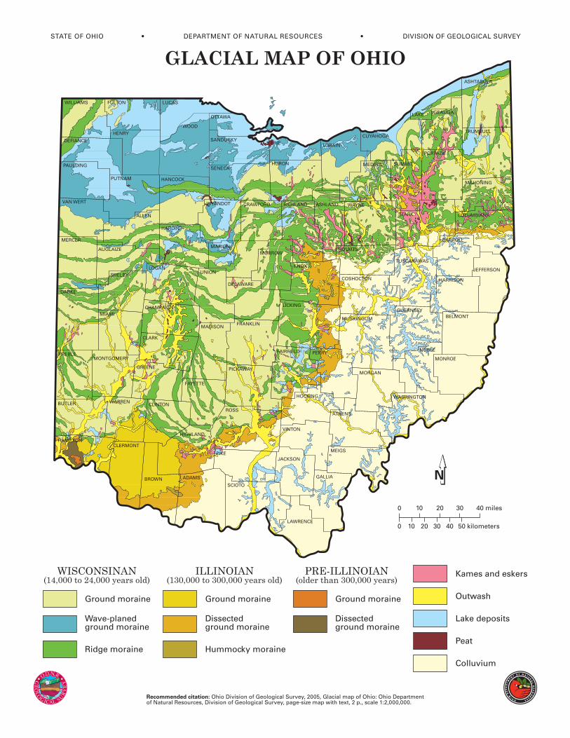
Although difficult to imagine, Ohio has at vari-
ous times in the recent geologic past (within the last
1.6 million years) had three-quarters of its surface
covered by vast sheets of ice perhaps as much as 1mile thick. This period of geologic history is referred
to as the Pleistocene Epoch or, more commonly, the
Ice Age, although there is abundant evidence that
Earth has experienced numerous other “ice ages”
throughout its 4.6 billion years of existence.
Ice Age glaciers invading Ohio formed in cen-tral Canada in response to climatic conditions that
allowed massive buildups of ice. Because of their
great thickness, these ice masses flowed under
their own weight and ultimately moved south as
far as northern Kentucky. Oxygen-isotope analysis
of deep-sea sediments indicates that more than adozen glaciations occurred during the Pleistocene.
Portions of Ohio were covered by the last two gla-
ciations, known as the Wisconsinan (the most re-
cent) and the Illinoian (older), and by an undeter-
mined number of pre-Illinoian glaciations.
Because each major advance covered depositsleft by the previous ice sheets, pre-Illinoian depos-
its are exposed only in extreme southwestern Ohio
in the vicinity of Cincinnati. Although the Illinoian
ice sheet covered the largest area of Ohio, its de-
posits are at the surface only in a narrow band
from Cincinnati northeast to the Ohio-Pennsylva-nia border. Most features shown on the map of gla-
cial deposits of Ohio are the result of the most re-
cent or Wisconsinan-age glaciers.
The material left by the ice sheets consists of
mixtures of clay, sand, gravel, and boulders in vari-
ous types of deposits of different modes of origin.Rock debris carried along by the glacier was de-
posited in two principal fashions, either directly
by the ice or by meltwater from the glacier. Some
material reaching the ice front was carried away
by streams of meltwater to form outwash depos-
its. Material deposited by water on and under thesurface of the glacier itself formed features called
kames and eskers, which are recognized by char-
acteristic shapes and composition. A distinctive
characteristic of glacial sediments that have been
deposited by water is that the material was sorted
by the water that carried it. Thus, outwash, kame,and esker deposits normally consist of sand and
gravel. The large boulder-size particles were left
behind and the smaller clay-size particles were
carried far away, leaving the intermediate gravel-
and sand-size material along the stream courses.
Material deposited directly from the ice wasnot sorted and ranges from clay to boulders. Some
of the debris was deposited as ridges parallel tothe edge of the glacier, forming terminal or end
moraines, which mark the position of the ice when
it paused for a period of time, possibly a few hun-
dred years. When the entire ice sheet receded be-
cause of melting, much of the ground-up rock mate-
rial still held in the ice was deposited on the surfaceas ground moraine. The oldest morainic deposits
in Ohio are of Illinoian and pre-Illinoian age. Ero-
sion has significantly reduced these deposits along
the glacial boundary, leaving only isolated rem-
nants that have been mapped as dissected ground
moraine and hummocky moraine.Many glacial lakes were formed in Ohio dur-
ing the Ice Age. Lake deposits are primarily
fine-grained clay- and silt-size sediments. The
most extensive area of lake deposits is in north-
ern Ohio bordering Lake Erie. These deposits, and
adjacent areas of wave-planed ground moraine,are the result of sedimentation and erosion by
large lakes that occupied the Erie basin as
Wisconsinan-age ice retreated into Canada. Other
lake deposits accumulated in stream valleys whose
outlets were temporarily dammed by ice or
outwash. Many outwash-dammed lake depositsare present in southeastern Ohio far beyond the
glacial boundary. Peat deposits are associated with
many lake deposits and formed through the accu-
mulation of partially decayed aquatic vegetation
in oxygen-depleted, stagnant water.The term glacial drift commonly is used to re-
fer to any material deposited directly (e.g., ground
moraine) or indirectly (e.g., outwash) by a glacier.
Because the ice that invaded Ohio came from
Canada, it carried in many rock types not found
in Ohio. Pebbles, cobbles, and boulders of theseforeign rock types are called erratics. Rock collect-
ing in areas of glacial drift may yield granite,
gneiss, trace quantities of gold, and very rarely,
diamonds. Most rocks found in glacial deposits,
however, are types native to Ohio.
Certain deposits left behind by the ice are ofeconomic importance, particularly sand and gravel,
clay, and peat. Sand and gravel that have been
sorted by meltwater generally occur as kames or
eskers or as outwash along major drainageways.
Sand and gravel are vital to Ohio’s construction
industry. Futhermore, outwash deposits are amongthe state’s most productive sources of ground water.
Glacial clay is used in cement and for common
clay products (particularly brick). The minor quan-
tities of peat produced in the state are used mainly
for mulch and soil conditioning.
GLACIAL DEPOSITS OF OHIO