richard mcintyre portfolio 2015
DESCRIPTION
ÂTRANSCRIPT
RICHARD MCINTYRE
PORTFOLIO 2015
Table of Contents

01 A Pathway Network for UCD BelfIeld 04 Histoirc, Location and Site Analysis 06 Analysis and Design Development 08 Masterplan 10 Detail Design and Boulevard Concept 12 Axonometric and Zooms 14 Visualisations 16
02 Forestry, not Forest 18 Analysis, Masterplan and Details 20 Consept Sections and Phasing 22 Visualisations 24
03 Fragment I 26
04 Fragment II 28
A Pathway Network for UCD BelfIeldAn Analysis of Perception to Evoke an Emotional Response
Institution: University College Dublin, IrelandType: Landscape Architecture, analysis, conceptual development design proposal, detailingLevel: Under-graduateDate: Summer 2014
An examination of the pathway network in Ire-lands largest university campus, University College Dublin. UCD is in a constant state of flux and thus one solution to the problems iden-tified cannot cover the overall issues through-out the campus. However the solution derived here can be applied to future development of the campus and the research carried out can inform future planning decisions to try and mit-igate the issues the campus is facing currently since its rapid expansion.
01
5
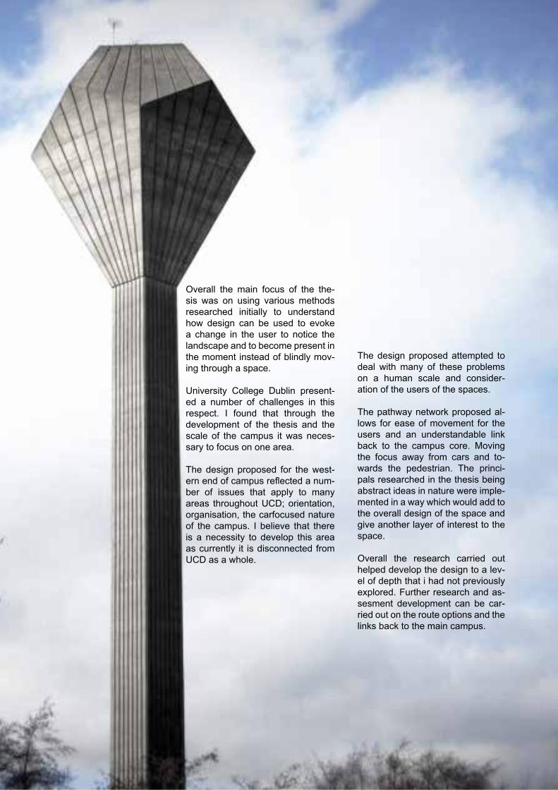
Overall the main focus of the the-sis was on using various methods researched initially to understand how design can be used to evoke a change in the user to notice the landscape and to become present in the moment instead of blindly mov-ing through a space.
University College Dublin present-ed a number of challenges in this respect. I found that through the development of the thesis and the scale of the campus it was neces-sary to focus on one area.
The design proposed for the west-ern end of campus reflected a num-ber of issues that apply to many areas throughout UCD; orientation, organisation, the carfocused nature of the campus. I believe that there is a necessity to develop this area as currently it is disconnected from UCD as a whole.
The design proposed attempted to deal with many of these problems on a human scale and consider-ation of the users of the spaces.
The pathway network proposed al-lows for ease of movement for the users and an understandable link back to the campus core. Moving the focus away from cars and to-wards the pedestrian. The princi-pals researched in the thesis being abstract ideas in nature were imple-mented in a way which would add to the overall design of the space and give another layer of interest to the space.
Overall the research carried out helped develop the design to a lev-el of depth that i had not previously explored. Further research and as-sesment development can be car-ried out on the route options and the links back to the main campus.

6
A Pathway Network for UCD BelfIeldAn Analysis of Perception to Evoke an Emotional Response
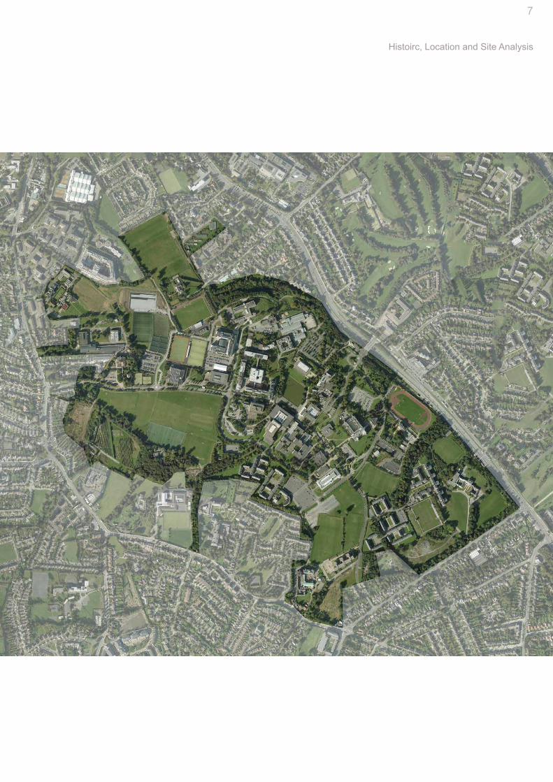
Belfield Campus has its origins in the 12th century. These lands have been passed down over the centuries, and how they have been distributed across a number of smaller estates, which now make up UCD’s modern campus.
The Belfield Campus is known for its parkland setting and mature land-scape, much of which was influenced by the 19th century estates. This is still evident through archaeological features, woodland boundaries, tree avenues and walled gardens. The uni-versity can trace its history to the in-stitution founded in 1854 and received its charter in 1908. The Irish govern-ment formally approved the transfer of UCD to Belfield on March 31st 1960.
The Science Building was developed immediately followed by an interna-tional competition for a campus mas-terplan. The winning entry, by archi-tect Andrej Wejchert has informed the evolution of the campus, as the student population figure envisaged in 1964 has grown in excess of 20,000.
Original Estate Boundries and Houses Historic Tree Lines 1829 to 1841
Historic Tree Lines 1897 to 1913 Current Tree Lines
7
Histoirc, Location and Site Analysis
8
A Pathway Network for UCD BelfIeldAn Analysis of Perception to Evoke an Emotional Response
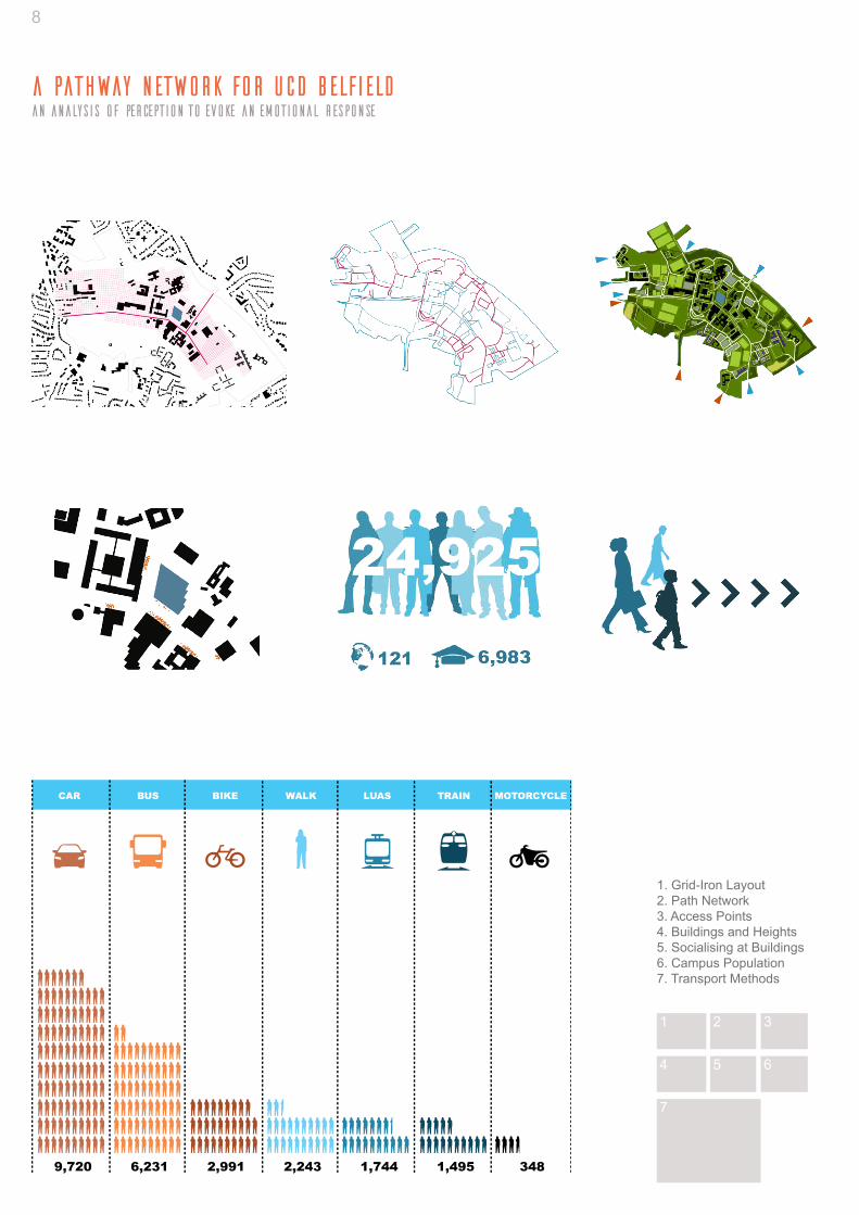
9,720 6,231 2,991 2,243 1,744 1,495 348
CAR BUS BIKE WALK LUAS TRAIN MOTORCYCLE
1 2 3
654
7
1. Grid-Iron Layout2. Path Network3. Access Points4. Buildings and Heights5. Socialising at Buildings6. Campus Population7. Transport Methods
9
Analysis and Design Development
Design Development
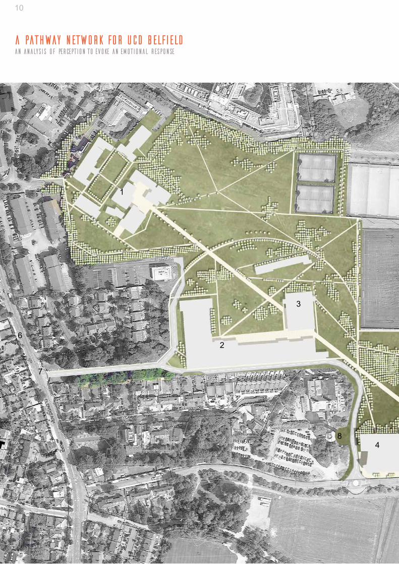
1. Entrance AreasInvestigate the entrance areas where the majority of students arrive at the campus. From the analysis it is clear that the car parks and the bus stop areas incur huge volumes of traffic each day. These areas however are underdeveloped and lack definition. Focus will be given to the entry points particularly the main gate, the Clonske-agh entrance and the larger car-parks located at the O’Reilly Hall, Richview and at the Quinn School. The main bus depot is where the majority of commuters enter the campus. This areas is of a high priority for intervention.
2. Social SpacesFrom the analysis carried out the majority of students tend to so-cialise just outside buildings. This is due to a lack of defined open space. It is proposed to create a cohesive system of links and spac-es through- out the campus. The assessment of routes pinpoints key intersections where people traffic accumulates. It is believed that theses areas would benefit directly from a more developed de-sign focusing on interac- tion rather than on quick movement be-tween buildings.
3. MovementMovement throughout the site is aimed primarily at getting from A to B in the quickest time possible. This is possibly due to the lack of seating or defined social/gathering spaces. The intention is to cre-ate defined spaces at intervals along routes which allow students to gather or relax within the campus core away from the buildings.
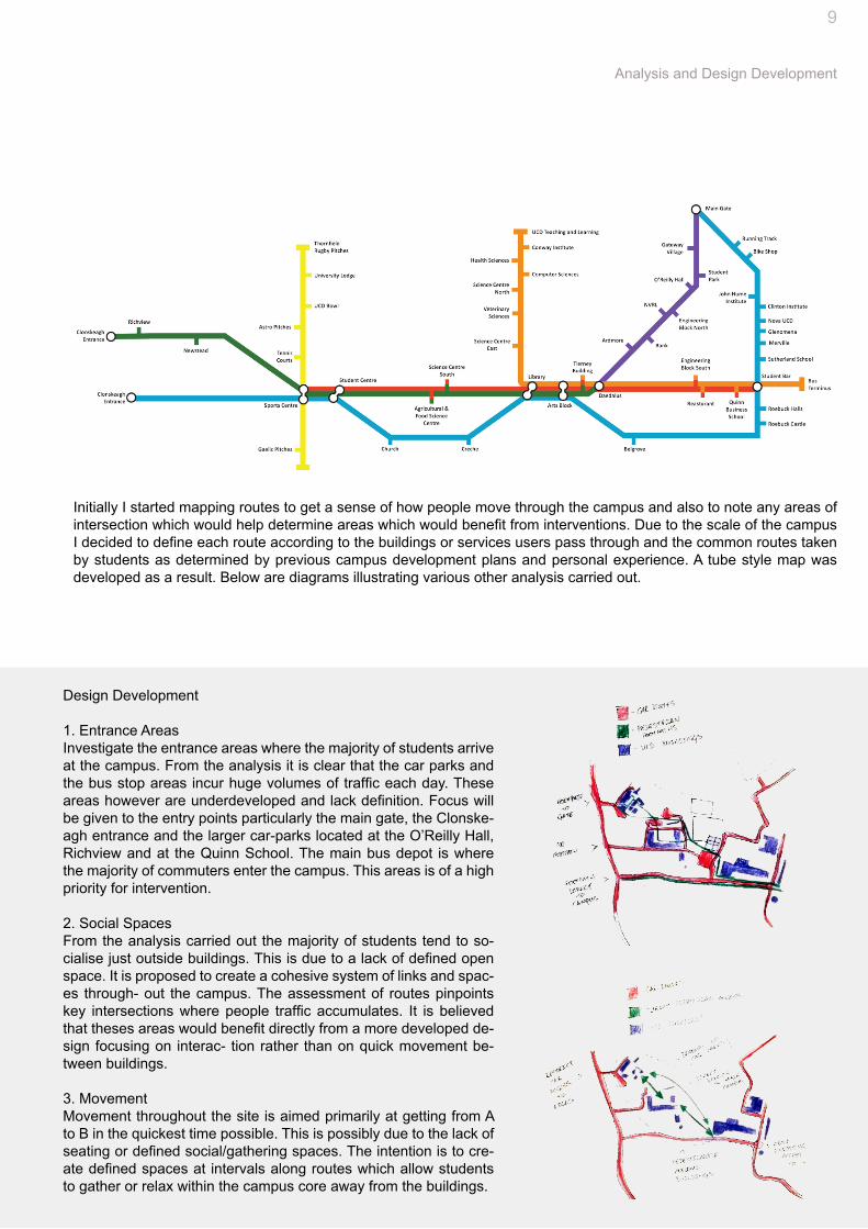
Initially I started mapping routes to get a sense of how people move through the campus and also to note any areas of intersection which would help determine areas which would benefit from interventions. Due to the scale of the campus I decided to define each route according to the buildings or services users pass through and the common routes taken by students as determined by previous campus development plans and personal experience. A tube style map was developed as a result. Below are diagrams illustrating various other analysis carried out.
10
A Pathway Network for UCD BelfIeldAn Analysis of Perception to Evoke an Emotional Response
1
6
7
2
3
48

11
Masterplan
Initially with the masterplan the cre-ation of direct routes based on desire lines was the main objective. From the development sketches it was obvious that the carparks were blocking po-tentially strong access routes. These carparks were removed in favour of al-lowing more direct routes. Access still remains to the Newstead building via its entrance at the Clonskeagh road and along the southern edge.
A propsed new road passing by the wa-ter tower to allow circulation between the southern edge now that the east carpark at the astro-pitches has been removed.
The new path network is based on de-sire lines between the buildings and the pitches mainly following as direct a route as is possible. A direct route from the Richview building to the sports centre was created. It passes through Newstead block C which is proposed to be removed as the building is poorly developed and underused. This direct route is proposed to 5 meters wide with the secondary routes being between 4 and 1 meters wide.
Planting is organised into linear rows along main routes using the principal of interval and screening. More organic planting is proposed in the larger open areas.
The pathways take the same form as the pathways on the main campus in their linear rigid form. The material used is that of a sand coloured as-phalt to mirror the walkway on the main campus. This is to link the area with the main campus mentally with the users.
5
1. Richview2. Newstead3. Newstead Block C 4. New Carpark5. Astro-Pitches6 Clonskeagh Road 7. Newstead Entrance8. Water Tower Aerial View

12
A Pathway Network for UCD BelfIeldAn Analysis of Perception to Evoke an Emotional Response
Boulevard Detail 1. Boulevard 2. Tree Line Planting
3. Covered Walkway 4. Open Spaces
1
13
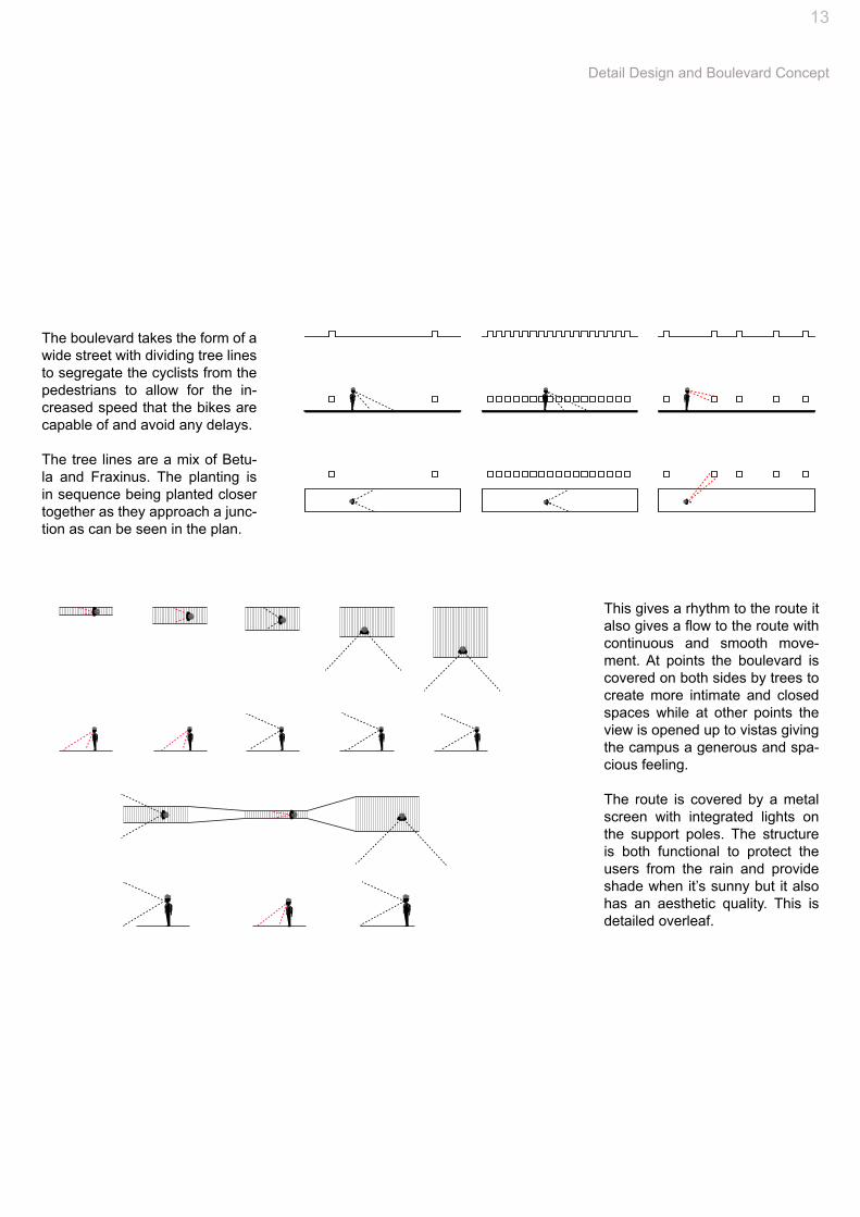
The boulevard takes the form of a wide street with dividing tree lines to segregate the cyclists from the pedestrians to allow for the in-creased speed that the bikes are capable of and avoid any delays.
The tree lines are a mix of Betu-la and Fraxinus. The planting is in sequence being planted closer together as they approach a junc-tion as can be seen in the plan.
Detail Design and Boulevard Concept
This gives a rhythm to the route it also gives a flow to the route with continuous and smooth move-ment. At points the boulevard is covered on both sides by trees to create more intimate and closed spaces while at other points the view is opened up to vistas giving the campus a generous and spa-cious feeling.
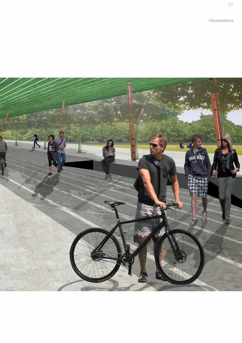
The route is covered by a metal screen with integrated lights on the support poles. The structure is both functional to protect the users from the rain and provide shade when it’s sunny but it also has an aesthetic quality. This is detailed overleaf.
14
A Pathway Network for UCD BelfIeldAn Analysis of Perception to Evoke an Emotional Response
15
Axonometric and Zooms
Section NTS

A Pathway Network for UCD BelfIeldAn Analysis of Perception to Evoke an Emotional Response
16
GREEN AREA
BOULEVA
RD
N11BUS STOP
MAIN GATE
CRID BUILDING
JOHN HUME INSTITUTE
NVRL
ARDMORE HOUSE
ENGINEERING BLOCK
TIERNEY BUILDING
DAEDALUS BUILDING
ARTS BLOCK
LIBRARY
LAKE
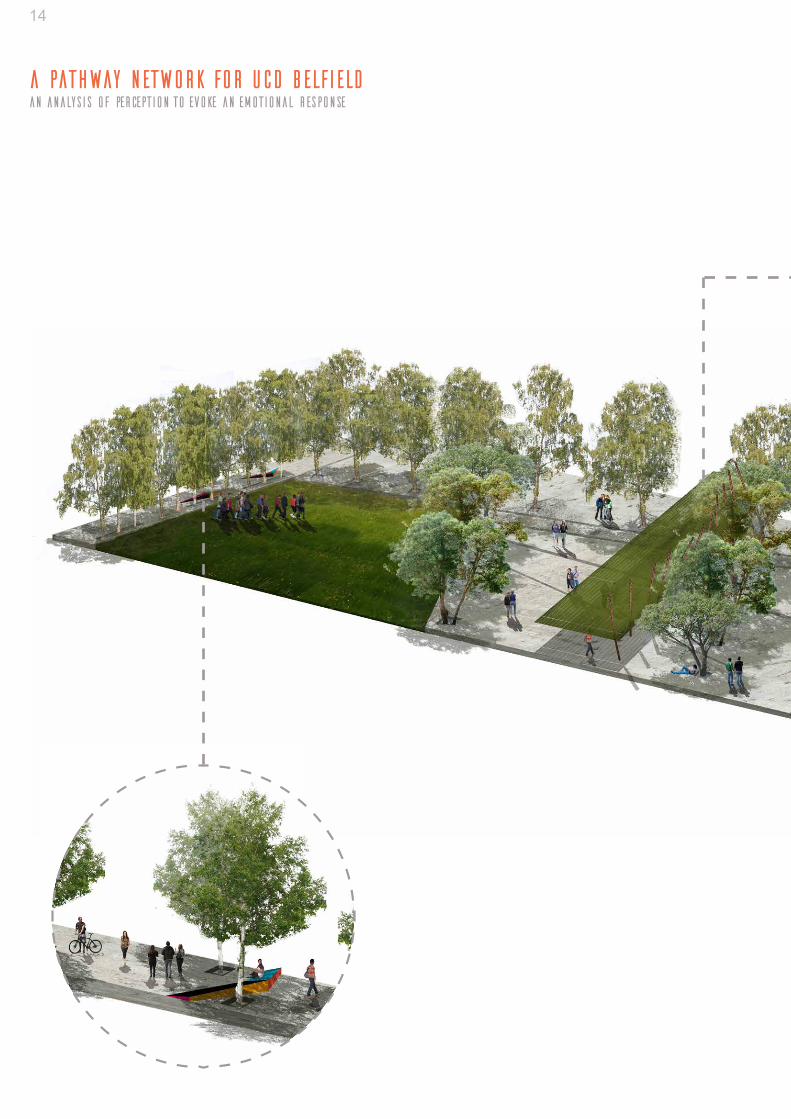
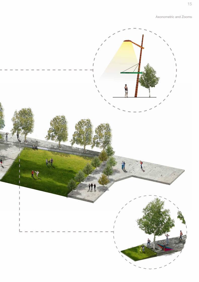
MOVEThe Boulevard:The boulevard runs from the main entrance of UCD south to join the central spine of the campus between the Tierney and Deadalus buildings. The pedes-trian boulevard will link the Gateway development and the surrounding city to the heart of the Campus both physically and visually. The central concept of designing movement is expressed in the design here in various ways. From previous research carried out it was found that the most effective way to engage people in the spaces that they move through, particularly in transitional spaces such as a long boulevard where the goal is to get from A to B, was to create a sequence of open spaces. Nodes of quiet contemplative spaces mixed with spaces of action and noise. A diversity of spaces, scales and functions. Initially the direct link between the main entrance at the N11 and the central campus spine was created. This route has been noted many times in the Campus Development Plans as high priority for development. This boule-vard would facilitate direct access to the campus core from the bus stop on the N11 for pedestrians and cyclists. A network of pedestrian routes off of this is proposed to ensure a high level of permeability on foot that would link to the central pedestrian street on campus and reinforce it. The roads here have been rerouted to give priority to the pedestrian and cycle users and curb the usage of cars to commute. This is illustrated overleaf. The boulevard takes the form of a wide street with dividing tree lines to segregate the cyclists from the pedestrians to allow for the increased speed that the bikes are capable of and avoid any delays. The tree lines are a mix of Betula and Fraxinus for their habit and form giving a narrow tall profile to offset the width of the boulevard. The planting is in sequence being planted closer together as they approach a junction as can be seen in the plan. This gives a rhythm to the route both through the way in which light passes through the gaps in the trees. It also gives a flow to the route with continuous and smooth movement. At points the boulevard is covered on both sides by trees to create more intimate and closed spaces while at other points the view is opened up to vistas giving the campus a generous and spacious feeling. The route is covered by a perforated metal screen with integrated lights on the support poles. The covering along the main spine of the campus is somewhat iconic of the UCD landscape and as such it seems appropriate to mirror this along the newly established pedestrian link. The structure is both func-tional to protect the users from the rain and provide shade when it’s sunny but it also has an aesthetic quality which the practically built original cover does not. This is detailed overleaf.
O P E N
L O U D
ACTIVE
EXCITING
Q U I E TCONTEM-P L A T I V E
R E L A X I N Gc h e e r f u l , r e s t f u l , h a p p y .
c a l m i n g , s o o t h i n g , comfo r t i ng, p e a c e f u l ,
1. Boulevard2. Tree Line Planting
Diagram of Sequence of Spaces
Location Diagram
Existing Conditions
Scetional Slice of Boulevard
3. Covered Walkway4. Open Spaces
Boulevard Detail Zoom and Section 1:200
1
1
2
2
3
3
44
4
17
Visualisations
GREEN AREA
BOULEVA
RD
N11BUS STOP
MAIN GATE
CRID BUILDING
JOHN HUME INSTITUTE
NVRL
ARDMORE HOUSE
ENGINEERING BLOCK
TIERNEY BUILDING
DAEDALUS BUILDING
ARTS BLOCK
LIBRARY
LAKE
MOVEThe Boulevard:The boulevard runs from the main entrance of UCD south to join the central spine of the campus between the Tierney and Deadalus buildings. The pedes-trian boulevard will link the Gateway development and the surrounding city to the heart of the Campus both physically and visually. The central concept of designing movement is expressed in the design here in various ways. From previous research carried out it was found that the most effective way to engage people in the spaces that they move through, particularly in transitional spaces such as a long boulevard where the goal is to get from A to B, was to create a sequence of open spaces. Nodes of quiet contemplative spaces mixed with spaces of action and noise. A diversity of spaces, scales and functions. Initially the direct link between the main entrance at the N11 and the central campus spine was created. This route has been noted many times in the Campus Development Plans as high priority for development. This boule-vard would facilitate direct access to the campus core from the bus stop on the N11 for pedestrians and cyclists. A network of pedestrian routes off of this is proposed to ensure a high level of permeability on foot that would link to the central pedestrian street on campus and reinforce it. The roads here have been rerouted to give priority to the pedestrian and cycle users and curb the usage of cars to commute. This is illustrated overleaf. The boulevard takes the form of a wide street with dividing tree lines to segregate the cyclists from the pedestrians to allow for the increased speed that the bikes are capable of and avoid any delays. The tree lines are a mix of Betula and Fraxinus for their habit and form giving a narrow tall profile to offset the width of the boulevard. The planting is in sequence being planted closer together as they approach a junction as can be seen in the plan. This gives a rhythm to the route both through the way in which light passes through the gaps in the trees. It also gives a flow to the route with continuous and smooth movement. At points the boulevard is covered on both sides by trees to create more intimate and closed spaces while at other points the view is opened up to vistas giving the campus a generous and spacious feeling. The route is covered by a perforated metal screen with integrated lights on the support poles. The covering along the main spine of the campus is somewhat iconic of the UCD landscape and as such it seems appropriate to mirror this along the newly established pedestrian link. The structure is both func-tional to protect the users from the rain and provide shade when it’s sunny but it also has an aesthetic quality which the practically built original cover does not. This is detailed overleaf.
O P E N
L O U D
ACTIVE
EXCITING
Q U I E TCONTEM-P L A T I V E
R E L A X I N Gc h e e r f u l , r e s t f u l , h a p p y .
c a l m i n g , s o o t h i n g , comfo r t i ng, p e a c e f u l ,
1. Boulevard2. Tree Line Planting
Diagram of Sequence of Spaces
Location Diagram
Existing Conditions
Scetional Slice of Boulevard
3. Covered Walkway4. Open Spaces
Boulevard Detail Zoom and Section 1:200
1
1
2
2
3
3
44
4
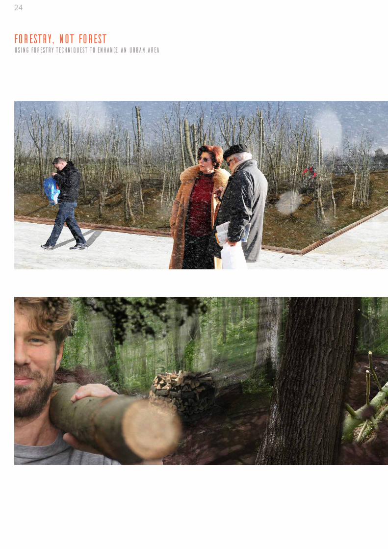
Forestry, not ForestUsing Forestry Techniquest to Enhance an Urban Area
Institution: University College Dublin, IrelandType: Landscape Architecture, analysis, conceptual development design proposal, detailingLevel: Under-graduateDate: Summer 2013
This project focused on designing a temporary intervention using forestry material and tech-niques and to illustrate how these techniques can beused to create unique spatial outcomes and experience for residents and visitors to Pelletstown, an urban area in west Dublin.
The time scale for this project was 21 years, after which the project will no longer exist, or will have been modified considerably to allow for building development.
02
19
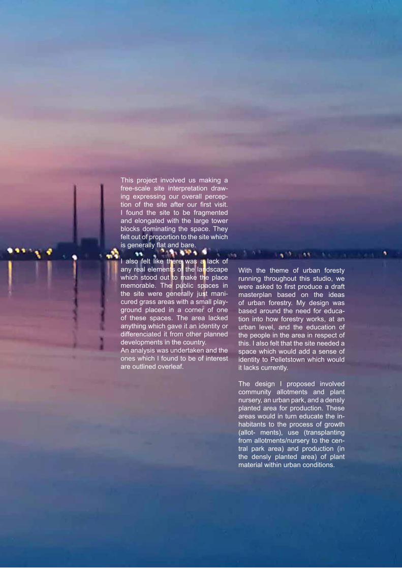
This project involved us making a free-scale site interpretation draw-ing expressing our overall percep-tion of the site after our first visit. I found the site to be fragmented and elongated with the large tower blocks dominating the space. They felt out of proportion to the site which is generally flat and bare.
I also felt like there was a lack of any real elements of the landscape which stood out to make the place memorable. The public spaces in the site were generally just mani-cured grass areas with a small play-ground placed in a corner of one of these spaces. The area lacked anything which gave it an identity or differenciated it from other planned developments in the country. An analysis was undertaken and the ones which I found to be of interest are outlined overleaf.
With the theme of urban foresty running throughout this studio, we were asked to first produce a draft masterplan based on the ideas of urban forestry. My design was based around the need for educa-tion into how forestry works, at an urban level, and the education of the people in the area in respect of this. I also felt that the site needed a space which would add a sense of identity to Pelletstown which would it lacks currently.
The design I proposed involved community allotments and plant nursery, an urban park, and a densly planted area for production. These areas would in turn educate the in-habitants to the process of growth (allot- ments), use (transplanting from allotments/nursery to the cen-tral park area) and production (in the densly planted area) of plant material within urban conditions.
20
Forestry, not ForestUsing Forestry Techniquest to Enhance an Urban Area
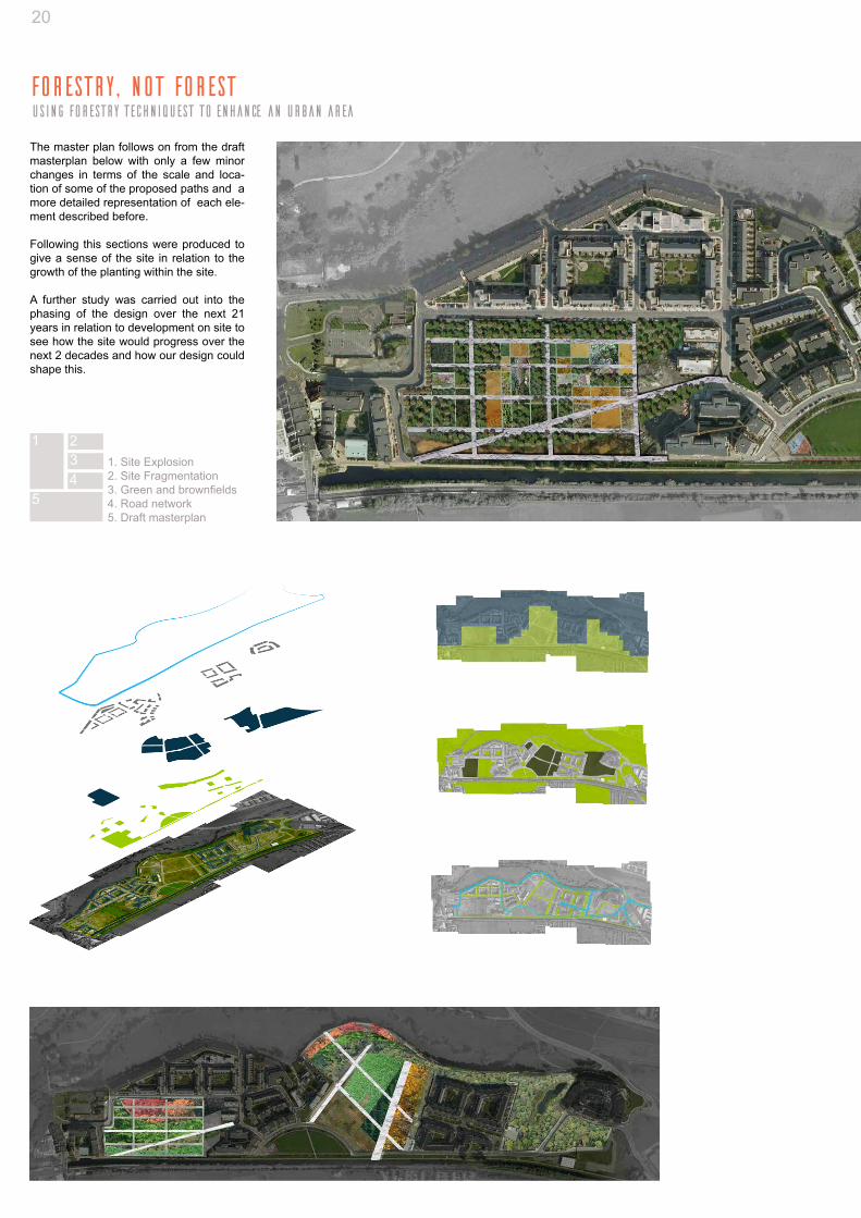
The master plan follows on from the draft masterplan below with only a few minor changes in terms of the scale and loca-tion of some of the proposed paths and a more detailed representation of each ele-ment described before.
Following this sections were produced to give a sense of the site in relation to the growth of the planting within the site.
A further study was carried out into the phasing of the design over the next 21 years in relation to development on site to see how the site would progress over the next 2 decades and how our design could shape this.
1 234
5
1. Site Explosion2. Site Fragmentation 3. Green and brownfields4. Road network5. Draft masterplan

21
Analysis, Masterplan and Details
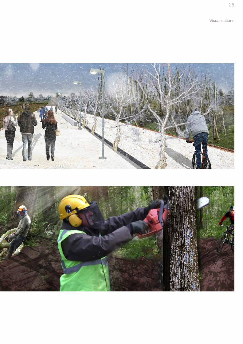
Young growth area consisting of a nursery and allotments. Here the residents can see how the trees are grown from youth. The allotments stem from the draft Local Area Plan for the area where a survey was carried out and al-lotments were requested. From analysis of the site this area appears to be the first place development will com-mence when it restarts so temporary and young plant-ing is suitable here. The planting takes the form of the future blocks and streets with trees placed along the fu-ture streets allowed to mature for permanant planting.
The Eastern end of the site is planted with a dense mix of trees for production purposes. Here the viability of certain species can be guaged to allow for a more informed planting plan in the future. Thinning and copicing will need to take place here to ensure the health of the trees along with regular transplan-tation to ensure that the trees can be replanted when they are removed in the future. The retention pool will be retained and aquatic planting can be experimented with here along with production of planting for SUDS for future developments.
The large central area is connected via intersecting path-ways to link the West and East of the site. This area takes the form of a large urban park. The northern part of this area is planted densly following the curve of the River Road. This planting continues along these lines to the nursery area in the South West. Dirt tracks are interspersed within the heavy planting to allow a more interesting route for us-ers opposed to the more angular avenues. Planting con-sist of diceduous, evergreen and mixed broadleaf. They are planted in a natural form to create a true forest effect.
Masterplan
Allotments
Urban Park
Production Area
22
Forestry, not ForestUsing Forestry Techniquest to Enhance an Urban Area

23
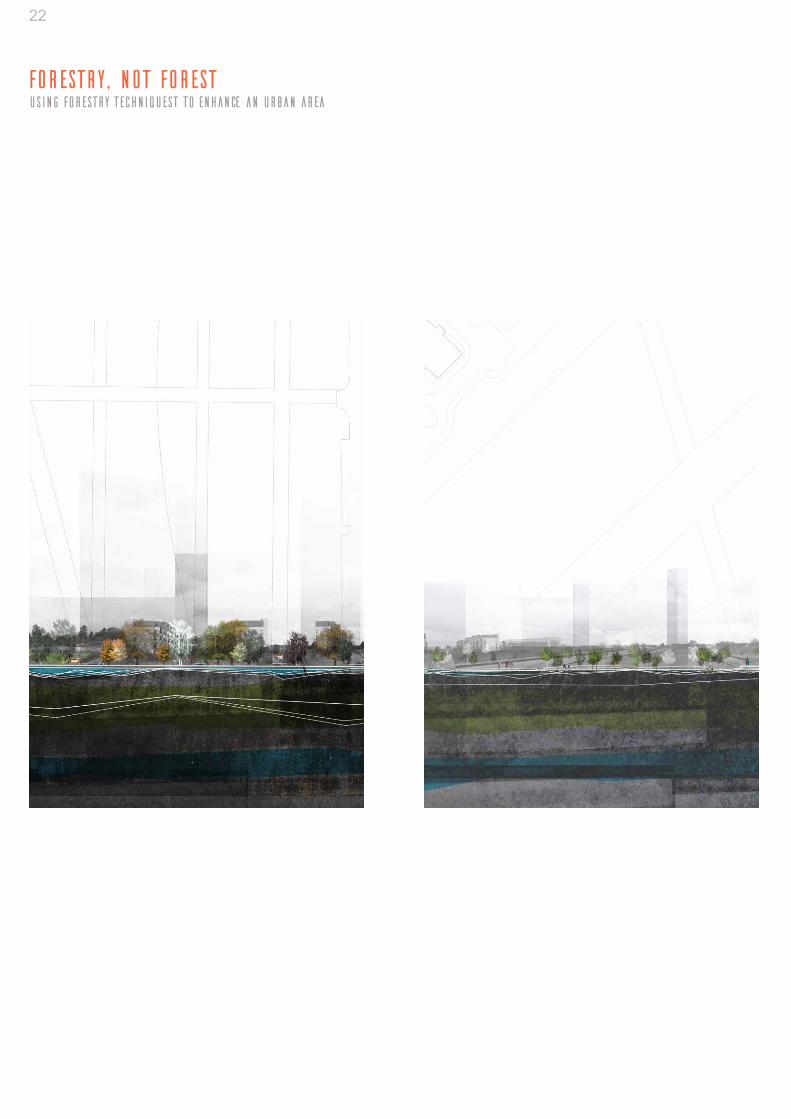
Road and Path Network Vegetation Areas Housing Development
The projected plan at 21 years shows the temporality of the design implemented for the Pelletstown site. The only remnants are the tree lines in the westurn area along the new roads. The planting to the north of the central site and throughout the middle which allows the new low density housing to be enclosed in a semi-forested area. The same applies to the easturn side. Overall the concept of Metamorphosis is achieved by the transformation from what appeared to be a flat expanse of space with large tower blocks to an integrated mix of high and low density housing with a strong “green” presence in the form of the urban forestry. It’s metamorphosis is complete
Consept Sections and Phasing
24
Forestry, not ForestUsing Forestry Techniquest to Enhance an Urban Area
25
Visualisations

Fragment IWhen is a Tree not a Tree?
Institution: University College Dublin, IrelandType: Conceptual development, 3D workLevel: Under-graduateDate: Winter 2013
For this project we were asked to create a three dimensional experimental and artistic ex-pression of the effects of human intervention on forest material and its resultant spatial char-acteristics.The final piece represents mans in-terference with the natural environment, spe-cifically the way in which human intervention can fragment and deteriorate the structure of a forest and its trees
Initially I started off by looking at the spatial and visual effect removing a tree from a for-est and the resulting void left behind. This then progressed on to the idea of perception and awareness of ones surroundings. This fo-cused me on the way that humans take over land and cut into the forests for both space and resources. This causes the forest to eventually become fragmented and can lead to isolation. I looked at the way that the natural line of the edge of a forest was degraded by human inter-vention and simplified this to basic squares. I then cut these strong shapes out of the wood and pushed them through to create tension and the feeling that a slight move further can cause the piece to collapse.
03

27
Institution: University College Dublin, IrelandType: Conceptual development, GraphicsLevel: Under-graduateDate: Winter 2013
Fragment IIMetamorphisis
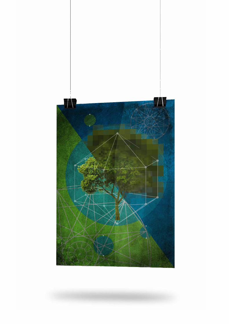
Using the ideas that have emerged from the 3D work of the sculpture and by teasing out my preconceptions of a selected site we were asked to construct an image which expresses information and ambience at the same time.
The poster I created was a represntation of the fragmented nature of some developments from the city in terms of its physical and mental de-tachment. This disconnection from the city led on to the idea of reconnection, which is repre-sented by the circles in the composition. The site is isolated in the geometric shape in the centre wanting to connect to the city it also rep-resents a cocoon and its transformitave prop-erties.
The motif of the compass represents further this idea of directionality and purpose in future development of the site area. The pixelated tree is used to describe the fragmented nature of the site and the change over time which can lead to it becoming complete on many levels.
04

Thank You