bugarski occupation
TRANSCRIPT
The Pontic-Danubian Realm
in the Period of the Great Migration

ARHEOLOŠKI INSTITUTBEOGRAD
POSEBNA IZDANJA, KNJIGA 51
COLLÈGE DE FRANCE – CNRS CENTRE DE RECHERCHE D’HISTOIRE
ET CIVILISATION DE BYZANCE
MONOGRAPHIES 36
The Pontic-Danubian Realm in the Period of the Great Migration
edited by
Vujadin Ivanišević & Michel Kazanski
Paris – Beograd 2012
Suivi de la publicationEmmanuelle Capet
Composition et infographieArtyom Ter-Markosyan-Vardanyan
© Association des amis du Centre d’histoire et civilisation de Byzance (ACHCByz) – 201052 rue du Cardinal-Lemoine – 75005 Paris
ISBN 978-2-916716-31-2 978-86-80093-78-9ISSN 0751-0594
ACHCByz Arheološki Institut Beograd
Published with a support of the
Ministry of Education and Science of Republic of Serbia
(Project n° 177021)
Вiдповiдальний редактор: Костянтин Цукерман
TABLE OF CONTENTS
Vujadin Ivanišević, Michel Kazanski. Préface .................................................... 7
I. The Balkans and the Middle Danube
Ivan Bugarski. Occupation of the south Pannonian soil during Antiquity and the Migration period: Šajkaška revisited ...................................... 11
Perica Špehar. The Danubian limes between Lederata and Aquae during the Migration period ................................................................................ 35
Vujadin Ivanišević. Barbarian settlements in the interior of Illyricum: The case of Caričin Grad .................................................................... 57
Tina Milavec. Late Antique settlements in Slovenia after the year 600 ........... 71
Federico Montinaro. Byzantium and the Slavs in the reign of Justinian: Comparing the two recensions of Procopius’s Buildings ...................... 89
Jaroslav Tejral. Cultural or ethnic changes? Continuity and discontinuity on the Middle Danube ca A.D. 500 ................................................... 115
Zuzana Loskotova. An early- 5th-century skeleton grave with gold neck-ring from Charváty (Moravia) ............................................ 189
Eszter Horvath. Cloisonné jewellery from the Langobardic Pannonia: Technological evidence of workshop practice ..................................... 207
Dieter Quast. Martial writers – Intellectual warriors: Remarks on a group of Late Antique male graves ............................................................... 243
II. The Occident
Joan Pinar Gil. Ponto-Danubian traditions of dress in early Visigothic Hispania: Chronology, dissemination, contexts and evolution . ........... 265
Eduard Droberjar. A propos des contacts entre l’empire d’Orient et les Germains de l’Elbe au vie siècle ................................................. 297
Dieter Quast. The Alamanni and Byzantium from the 5th to the 7th century ...... 317
III. The Northern Pontus
Aleksandr Ermolin. Džurga-Oba – a cemetery of the Great Migration period in the Cimmerian Bosporus ............................................................... 339
Damien Glad. The Empire’s influence on the barbarian elites from the Pontic region to the Rhine (5th-7th centuries): A case study of lamellar weapons and segmental helmet .......................................................... 349
Alekseï Fourassiev. Byzance et la Crimée du Sud-Ouest au vie siècle : relations culturelles et particularités du costume féminin .................... 363
Michel Kazanski. Radaigaise et la fin de la civilisation de Černjahov .............. 381
OCCUPATION OF THE SOUTH PANNONIAN SOIL DURING LATE ANTIQUITY AND THE MIGRATION PERIOD:
ŠAJKAŠKA REVISITED
Ivan Bugarski
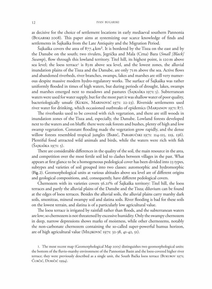
I. An introduction to the Šajkaška landscape and research history
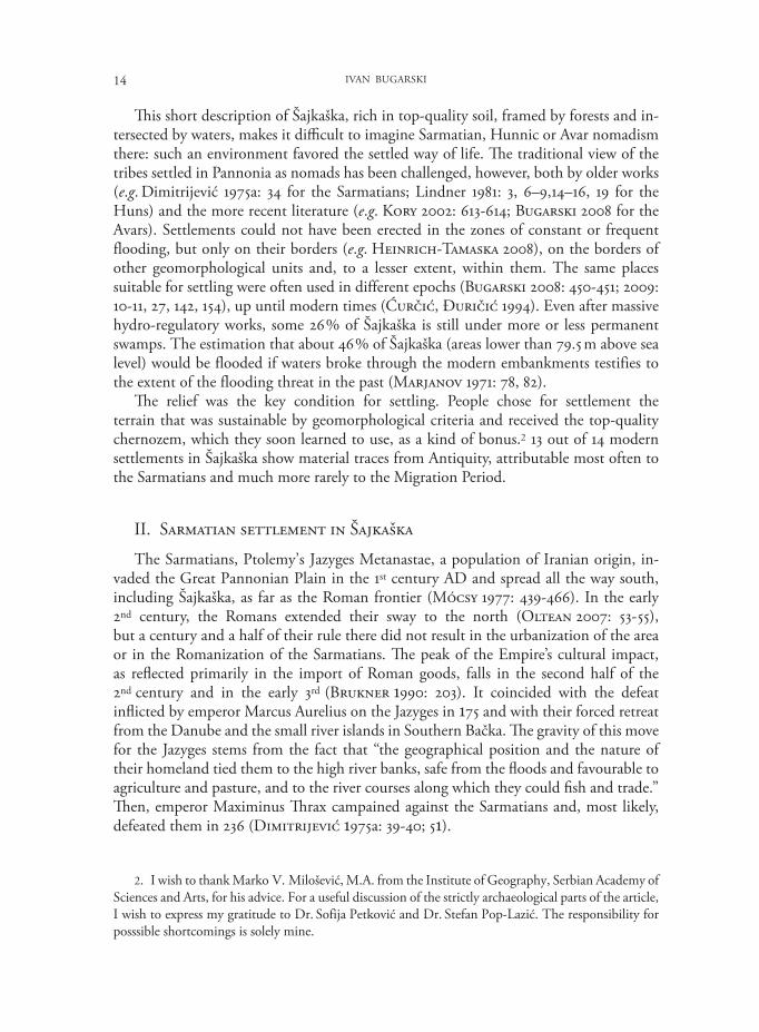
Šajkaška is the southeast corner of the Bačka region in the present-day northern Ser bi an province of Vojvodina (Fig. 1). Two collective volumes from the 1970’s were ded i cated to this area: the first depicted its natural setting (Šajkaška 1971) and the second con tained two important articles by D. Dimitrijević (1975a; 1975b) devoted to its archaeological and historical heritage. My contribution is based on these studies, on others that followed, and on the recently developed methodology which sets the geomorphological principle
Vujadin Ivanišević and Michel Kazanski eds, The Pontic-Danubian Realm in the Period of the Great Migration (Centre de recherche d’Histoire et Civilisation de Byzance, Monographies 36 / Arheološki institut, Posebna izdanja, Knjiga 51), Paris-Beograd 2012.
Fig. 1: Geomorphological Map of Šajkaška – in grey – (after Geomorphological Map 2005)
12 IVAN BUGARSKI
1. The most recent map (Geomorphological Map 2005) distinguishes two geomorphological units: the bottom of the fluvio-marshy environment of the Pannonian Basin and the loess-covered higher river terrace; they were previously described as a single unit, the South Bačka loess terrace (Bukurov 1971; Ćurčić, Đuričić 1994).
as decisive for the choice of settlement locations in early mediaeval southern Pannonia (Bugarski 2008). This paper aims at systemizing our scarce knowledge of finds and settlements in Šajkaška from the Late Antiquity and the Migration Period.
Šajkaška covers the area of 877.4 km². It is bordered by the Tisza on the east and by the Danube on the south; two rivulets, Jegrička and Mala (Crna) Bara (Small [Black] Swamp), flow through this lowland territory. Titel hill, its highest point, is 120 m above sea level; the loess terrace1 is 83 m above sea level, and the lowest zones, the alluvial inundation plains of the Tisza and the Danube, are only 71 m above the sea. Active flows and abandoned riverbeds, river branches, swamps, lakes and marshes are still very nu mer-ous despite massive modern hydro-regulatory works. The surface of Šajkaška was rather uniformly flooded in times of high waters, but during periods of drought, lakes, swamps and marshes emerged next to meadows and pastures (Šajkaška 1971: 5). Subterranean waters were used for water supply, but for the most part it was shallow water of poor quality, bacteriologically unsafe (Kukin, Marinović 1971: 22-23). Riverside settlements used river water for drinking, which occasioned outbreaks of epidemics (Marjanov 1971: 87).
The riverbanks used to be covered with rich vegetation, and there are still woods in inundation zones of the Tisza and, especially, the Danube. Lowland forests developed next to the waters and on bluffs: there were oak forests and bushes, plenty of high and low swamp vegetation. Constant flooding made the vegetation grow rapidly, and the dense willow forests resembled tropical jungles (Babić, Parabućski 1971: 114-115, 119, 136). Plentiful food attracted wild animals and birds, while the waters were rich with fish (Šajkaška 1971: 5).
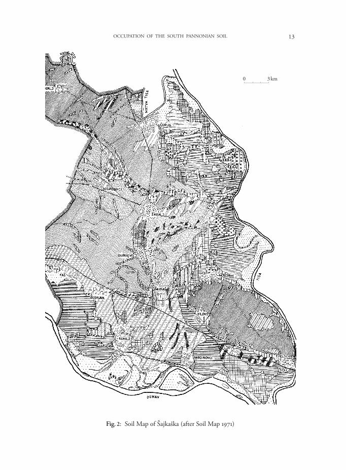
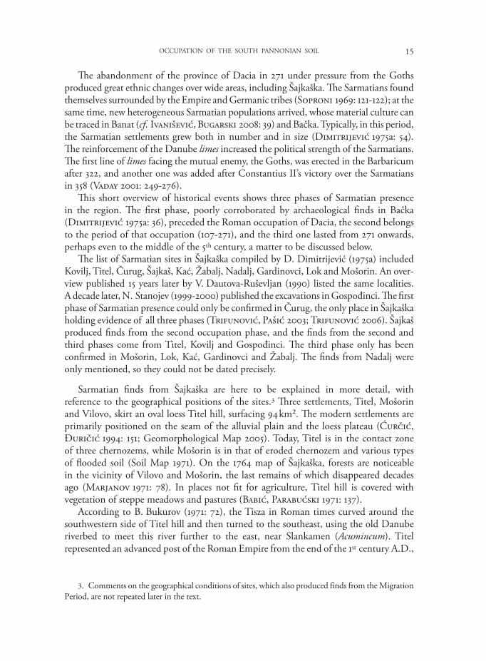
There are considerable differences in the quality of the soil, the main resource in the area, and competition over the most fertile soil led to clashes between villages in the past. What appears at first glance to be a homogeneous pedological cover has been divided into 23 types, subtypes and varieties of soil grouped into two classes: automorphic and hydromorphic (Fig. 2). Geomorphological units at various altitudes above sea level are of different origins and geological compositions, and, consequently, have different pedological covers.
Chernozem with its varieties covers 56.21% of Šajkaška territory: Titel hill, the loess terraces and partly the alluvial plains of the Danube and the Tisza; diluvium can be found at the edges of loess terraces. Besides the alluvial soils, the alluvial plains carry marshy dark soils, smonitzas, mineral swampy soil and slatina soils. River flooding is bad for these soils on the lowest terrain, and slatina is of a particularly low agricultural value.
The loess terrace is irrigated by rainfall rather than floods, and the subterranean waters are low; so chernozem is not threatened by excessive humidity. Only the swampy chernozem in deep, narrow depressions shows marks of moistness, while other chernozems, notably the non-carbonate chernozem containing the so-called super-powerful humus horizon, are of high agricultural value (Miljković 1971: 32-38, 41-42, 51).
13OCCUPATION OF THE SOUTH PANNONIAN SOIL
Fig. 2: Soil Map of Šajkaška (after Soil Map 1971)
0 3 km
14 IVAN BUGARSKI
2. I wish to thank Marko V. Milošević, M.A. from the Institute of Geography, Serbian Academy of Sciences and Arts, for his advice. For a useful discussion of the strictly archaeological parts of the article, I wish to express my gratitude to Dr. Sofija Petković and Dr. Stefan Pop-Lazić. The responsibility for posssible shortcomings is solely mine.
This short description of Šajkaška, rich in top-quality soil, framed by forests and in-ter sected by waters, makes it difficult to imagine Sarmatian, Hunnic or Avar nomadism there: such an environment favored the settled way of life. The traditional view of the tribes settled in Pannonia as nomads has been challenged, however, both by older works (e.g. Dimitrijević 1975a: 34 for the Sarmatians; Lindner 1981: 3, 6–9,14–16, 19 for the Huns) and the more recent literature (e.g. Kory 2002: 613-614; Bugarski 2008 for the Avars). Settlements could not have been erected in the zones of constant or frequent flooding, but only on their borders (e.g. Heinrich-Tamaska 2008), on the borders of other geomorphological units and, to a lesser extent, within them. The same places suitable for settling were often used in different epochs (Bugarski 2008: 450-451; 2009: 10-11, 27, 142, 154), up until modern times (Ćurčić, Đuričić 1994). Even after massive hydro-regulatory works, some 26 % of Šajkaška is still under more or less permanent swamps. The estimation that about 46 % of Šajkaška (areas lower than 79.5 m above sea level) would be flooded if waters broke through the modern embankments testifies to the extent of the flooding threat in the past (Marjanov 1971: 78, 82).
The relief was the key condition for settling. People chose for settlement the terrain that was sustainable by geomorphological criteria and received the top-quality chernozem, which they soon learned to use, as a kind of bonus.2 13 out of 14 modern settlements in Šajkaška show material traces from Antiquity, attributable most often to the Sarmatians and much more rarely to the Migration Period.
II. Sarmatian settlement in Šajkaška
The Sarmatians, Ptolemy’s Jazyges Metanastae, a population of Iranian origin, in-va ded the Great Pannonian Plain in the 1st century AD and spread all the way south, including Šajkaška, as far as the Roman frontier (Mócsy 1977: 439-466). In the early 2nd century, the Romans extended their sway to the north (Oltean 2007: 53- 55), but a century and a half of their rule there did not result in the urbanization of the area or in the Romanization of the Sarmatians. The peak of the Empire’s cultural impact, as reflected primarily in the import of Roman goods, falls in the second half of the 2nd century and in the early 3rd (Brukner 1990: 203). It coincided with the defeat inflicted by emperor Marcus Aurelius on the Jazyges in 175 and with their forced retreat from the Danube and the small river islands in Southern Bačka. The gravity of this move for the Jazyges stems from the fact that “the geographical position and the nature of their homeland tied them to the high river banks, safe from the floods and favourable to agriculture and pasture, and to the river courses along which they could fish and trade.” Then, emperor Maximinus Thrax campained against the Sarmatians and, most likely, defeated them in 236 (Dimitrijević 1975a: 39-40; 51).
15OCCUPATION OF THE SOUTH PANNONIAN SOIL
3. Comments on the geographical conditions of sites, which also produced finds from the Migration Period, are not repeated later in the text.
The abandonment of the province of Dacia in 271 under pressure from the Goths produced great ethnic changes over wide areas, including Šajkaška. The Sarmatians found themselves surrounded by the Empire and Germanic tribes (Soproni 1969: 121-122); at the same time, new heterogeneous Sarmatian populations arrived, whose material culture can be traced in Banat (cf. Ivanišević, Bugarski 2008: 39) and Bačka. Typically, in this period, the Sarmatian settlements grew both in number and in size (Dimitrijević 1975a: 54). The reinforcement of the Danube limes increased the political strength of the Sarmatians. The first line of limes facing the mutual enemy, the Goths, was erected in the Barbaricum after 322, and another one was added after Constantius II’s victory over the Sarmatians in 358 (Vaday 2001: 249-276).
This short overview of historical events shows three phases of Sarmatian presence in the region. The first phase, poorly corroborated by archaeological finds in Bačka (Dimitrijević 1975a: 36), preceded the Roman occupation of Dacia, the second belongs to the period of that occupation (107-271), and the third one lasted from 271 onwards, perhaps even to the middle of the 5th century, a matter to be discussed below.
The list of Sarmatian sites in Šajkaška compiled by D. Dimitrijević (1975a) included Kovilj, Titel, Čurug, Šajkaš, Kać, Žabalj, Nadalj, Gardinovci, Lok and Mošorin. An over-view published 15 years later by V. Dautova-Ruševljan (1990) listed the same localities. A decade later, N. Stanojev (1999-2000) published the excavations in Gospođinci. The first phase of Sarmatian presence could only be confirmed in Čurug, the only place in Šajkaška holding evidence of all three phases (Trifunović, Pašić 2003; Trifunović 2006). Šajkaš produced finds from the second occupation phase, and the finds from the second and third phases come from Titel, Kovilj and Gospođinci. The third phase only has been confirmed in Mošorin, Lok, Kać, Gardinovci and Žabalj. The finds from Nadalj were only mentioned, so they could not be dated precisely.
Sarmatian finds from Šajkaška are here to be explained in more detail, with reference to the geographical positions of the sites.3 Three settlements, Titel, Mošorin and Vilovo, skirt an oval loess Titel hill, surfacing 94 km². The modern settlements are primarily positioned on the seam of the alluvial plain and the loess plateau (Ćurčić, Đuričić 1994: 151; Geomorphological Map 2005). Today, Titel is in the contact zone of three chernozems, while Mošorin is in that of eroded chernozem and various types of flooded soil (Soil Map 1971). On the 1764 map of Šajkaška, forests are noticeable in the vicinity of Vilovo and Mošorin, the last remains of which disappeared decades ago (Marjanov 1971: 78). In places not fit for agriculture, Titel hill is cov ered with vegetation of steppe meadows and pastures (Babić, Parabućski 1971: 137).
According to B. Bukurov (1971: 72), the Tisza in Roman times curved around the south western side of Titel hill and then turned to the southeast, using the old Danube riverbed to meet this river further to the east, near Slankamen (Acumincum). Titel represented an advanced post of the Roman Empire from the end of the 1st century A.D.,
16 IVAN BUGARSKI
and while the archaeological proofs for an earthen (?) fortification are missing, there is some epigraphical evidence (Dimitrijević 1975a: 43-45; 1996: 25). Renewed after the Marcomannic wars, the fortification existed in the 3rd century as well, as indicated by three monuments dedicated to Roman emperors (Dušanić 1965: 92-94, n. 49; 1967: 202-205, n. 37; 1968: 95-96). The fortification, most likely the strategic point contra Acinco mentioned by Hydatius (Jovanović 2005: 85), was a part of the limes system and probably a harbour of the classis Flavia Pannonica, still active in the late 3rd century and into the first half of the 4th (Dimitrijević 1975a: 45-47, 58; 1996: 23-31). However, the only archaeological confirmation of the presence of the classis Flavia Pannonica in the area, dated to the 4th century, comes from Progar in Srem (Dautova-Ruševljan, Vujović 2006: 26).
The Sarmatians dwelled in the vicinity of the fort. A grave of a rather wealthy woman, probably from the first half of the 2nd century, was discovered in Titel. Finds of later Sarmatian pottery are dated widely, from 270 to 450. North of the town, on Titel hill, shreds of Sarmatian pottery and pieces of plaster indicate that a Sarmatian settlement existed near the fortification, extra muros (Dimitrijević 1975a: 42, n. 26; 46, 58).
At least four 4th-century Sarmatian settlements were found in Mošorin, where a ceme-tery of nine graves has been excavated as well (at the Kraljev surduk site). Some mis un-der standings arose from the initial ethnic interpretation of the Sarmatian settlement at the Bostanište site (Dimitrijević 1975a: 56-58; cf. Veselinović 1953; Takács 2000a: 409), where a 4th-century cemetery was also discovered (Đorđević 1990: 122; cf. Bugarski 2008: n. 22). So far, there are no settlement traces from Vilovo, at the foot of Titel hill; only a fragmented tombstone was found in this place (Đorđević 2007: 88).
Lok is positioned next to Titel hill, on the seam of the lower river terrace and alluvial plain (Geomorphological Map 2005), and on meadow chernozem in contact with flooded soil (Soil Map 1971). Of all villages in Šajkaška, Lok would be most threatened by high waters (Marjanov 1971: 78). Numerous surface finds of the late Sarmatian grey pottery at the Gradački surduk site indicate the existence of a settlement (Dimitrijević 1975a: 56).
The loess-covered higher terrace along the left bank of the Danube borders mostly on the alluvial plain. Kać, Budisava, Kovilj and Gardinovci are positioned on that seam. Erected on a higher geomorphological unit, Kovilj and Gardinovci deeply penetrate the lower terrain (Ćurčić, Đuričić 1994: 152; Geomorphological Map 2005). In the sand dunes that stretch between Kovilj and Gardinovci, the alluvial plain of the Danube meets the alluvial plain of the Tisza curving around Titel hill (Bukurov 1971: 71, 72). Forests grow opposite these villages (Babić, Parabućski 1971: 119-120). Kać, Kovilj and Gardinovci are positioned on chernozem on sand, bordering on other chernozems and soils of lesser quality (Soil Map 1971).
The Museum of Vojvodina has some Roman bronze coins from Kać (Dautova-Ruševljan 1974-1978: 63), which also produced Sarmatian finds mostly dated to the 4th century. Cemeteries and settlements have been detected in a few localities, including the Vinogradi and Čot II sites, along the Kać – Kovilj road (Dimitrijević 1975a: 54-55, n. 67). In Donji Kovilj, there is a 2nd-century cemetery (Dimitrijević 1975a: 41), and a 3rd- 4th centuries necropolis stretches along the Kovilj canal (Stanojev 1999-2000: 33, n. 19).
17OCCUPATION OF THE SOUTH PANNONIAN SOIL
Some 4th century Roman coins have been found (Dautova-Ruševljan 1974-1978) and Late Sarmatian settlements observed at three sites in Gardinovci. D. Dimitrijević (1975a: 55-56) noted that one of them was positioned at the old confluence of the Danube and the Tisza.
Nadalj is situated on a fertile chernozem (Soil Map 1971) between two loess valleys; it is bordered by the Jegrička and the Krivaja (Geomorphological Map 2005). Surface pottery finds indicate a Sarmatian settlement, with no further data (Dimitrijević 1975a: 55). There are no records of Sarmatian settlements from Budisava and Đurđevo, although these places are protected from high waters (Marjanov 1971: 78) and are in contact with chernozems (Soil Map 1971).
Čurug is positioned on the southern part of the Tisza river branch, formed in the north, near Bečej, and encircling a large holm (Trifunović 2006). It is situated on the border of the bottom of the fluvio-marshy environment in the Pannonian Basin and the Tisza alluvial plain, on the higher unit (Ćurčić, Đuričić 1994: 152; Geomorphological Map 2005), and also on the contact of typical chernozem, the non-carbonate chernozem and two types of alluvium (Soil Map 1971). On the other side, between Čurug and Nadalj there is a stretch of pasture called ’livade’ (meadows) (Vujević 1939: 9). Together with Nadalj, Gospođinci and Budisava, Čurug is one of the settlements that would be best protected in case the waters broke through the modern embankments (Marjanov 1971: 78). On the elevated terrain of the old Tisza riverbank, there are damaged Sarmatian cemeteries at Gornji boronj (Slavnić 1952; Manojlović 1969-1970: 301) and Ciglana (Brick factory) (Dimitrijević 1975a: 43) sites.
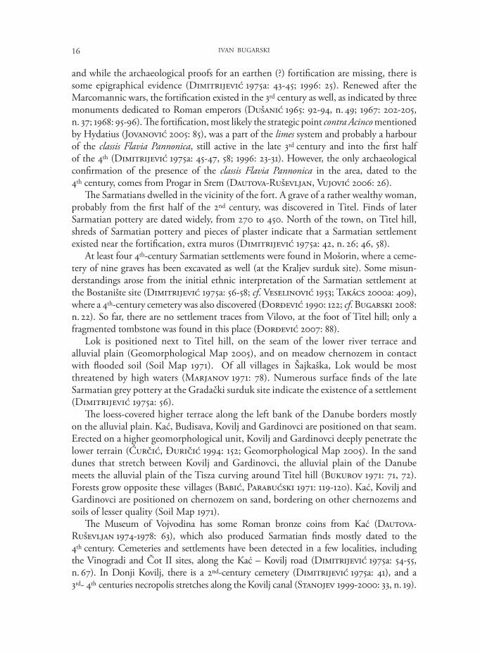
The site of Stari Vinogradi (Old vineyards), excavated by S. Trirfunović (2006), is the most important and best explored in Šajkaška. This multi-layered site of some 50 hectares is partly overbuilt by the modern village of Čurug (municipality of Žabalj). Before the hydro-regulatory works, there was a striking difference in elevation, perhaps the biggest in the area, between the settlement located on a high bank and a big fen below. The toponym Stari Vinogradi, denoting the best agricultural soil, identifies the site as very suitable for settling (Marjanov 1971: 92). It produced at least 530 archaeological entities, dated from the Bronze Age to the 17th century (Fig. 3).
Fig. 3: Čurug, the situation plan (after Trifunović 2006 )10 m
18 IVAN BUGARSKI
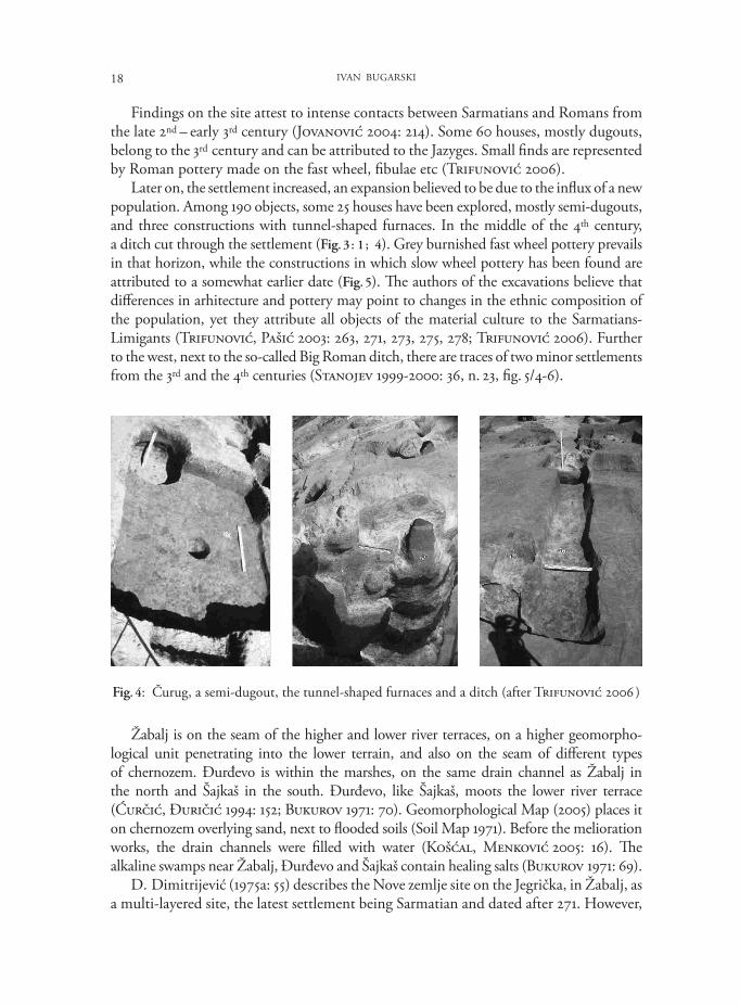
Findings on the site attest to intense contacts between Sarmatians and Romans from the late 2nd – early 3rd century (Jovanović 2004: 214). Some 60 houses, mostly dugouts, belong to the 3rd century and can be attributed to the Jazyges. Small finds are represented by Roman pottery made on the fast wheel, fibulae etc (Trifunović 2006).
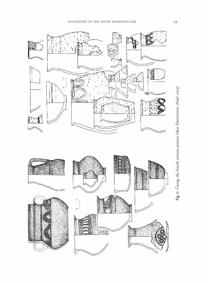
Later on, the settlement increased, an expansion believed to be due to the influx of a new population. Among 190 objects, some 25 houses have been explored, mostly semi-dugouts, and three constructions with tunnel-shaped furnaces. In the middle of the 4th century, a ditch cut through the settlement (Fig. 3 : 1 ; 4). Grey burnished fast wheel pottery prevails in that horizon, while the constructions in which slow wheel pottery has been found are attributed to a somewhat earlier date (Fig. 5). The authors of the excavations believe that differences in arhitecture and pottery may point to changes in the ethnic composition of the population, yet they attribute all objects of the material culture to the Sarmatians-Limigants (Trifunović, Pašić 2003: 263, 271, 273, 275, 278; Trifunović 2006). Further to the west, next to the so-called Big Roman ditch, there are traces of two minor settlements from the 3rd and the 4th centuries (Stanojev 1999-2000: 36, n. 23, fig. 5/4-6).
Fig. 4: Čurug, a semi-dugout, the tunnel-shaped furnaces and a ditch (after Trifunović 2006 )
Žabalj is on the seam of the higher and lower river terraces, on a higher geo mor pho-logical unit penetrating into the lower terrain, and also on the seam of different types of chernozem. Đurđevo is within the marshes, on the same drain channel as Žabalj in the north and Šajkaš in the south. Đurđevo, like Šajkaš, moots the lower river terrace (Ćurčić, Đuričić 1994: 152; Bukurov 1971: 70). Geomorphological Map (2005) places it on chernozem overlying sand, next to flooded soils (Soil Map 1971). Before the melioration works, the drain channels were filled with water (Košćal, Menković 2005: 16). The alkaline swamps near Žabalj, Đurđevo and Šajkaš contain healing salts (Bukurov 1971: 69).
D. Dimitrijević (1975a: 55) describes the Nove zemlje site on the Jegrička, in Žabalj, as a multi-layered site, the latest settlement being Sarmatian and dated after 271. However,
19OCCUPATION OF THE SOUTH PANNONIAN SOIL
Fig.
5:
Čur
ug, t
he fo
urth
cen
tury
pot
tery
(afte
r Tri
funo
vić,
Paš
ić 2
003)
05
05
20 IVAN BUGARSKI
the preliminary report on the excavations at Nove zemlje (Vilotijević 1965), incorrectly cited by D. Dimitrijević, contains no record of the Sarmatian occupation phase of the site. Other sites in the vicinity of the village, on protrusions that mostly follow the course of the Jegrička, show remains of Sarmatian settlements (Dimitrijević 1975a: 55).
Two damaged graves and shreds of Sarmatian pottery were found in Šajkaš, at the site of Jelin breg, while along the Mošorin - Šajkaš road, east of the village, some ruined skeleton graves and remains of another settlement have been noted, dated prior to the abandoning of Dacia in 271 (Dimitrijević 1975a: 42-43).
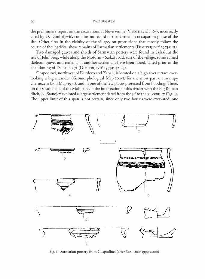
Gospođinci, northwest of Đurđevo and Žabalj, is located on a high river terrace over-looking a big meander (Geomorphological Map 2005), for the most part on swampy chernozem (Soil Map 1971), and in one of the few places protected from flooding. There, on the south bank of the Mala bara, at the intersection of this rivulet with the Big Roman ditch, N. Stanojev explored a large settlement dated from the 3rd to the 5th century (Fig. 6). The upper limit of this span is not certain, since only two houses were excavated: one
Fig. 6: Sarmatian pottery from Gospođinci (after Stanojev 1999-2000)
1
2
3
4
6
7
5
0 5
21OCCUPATION OF THE SOUTH PANNONIAN SOIL
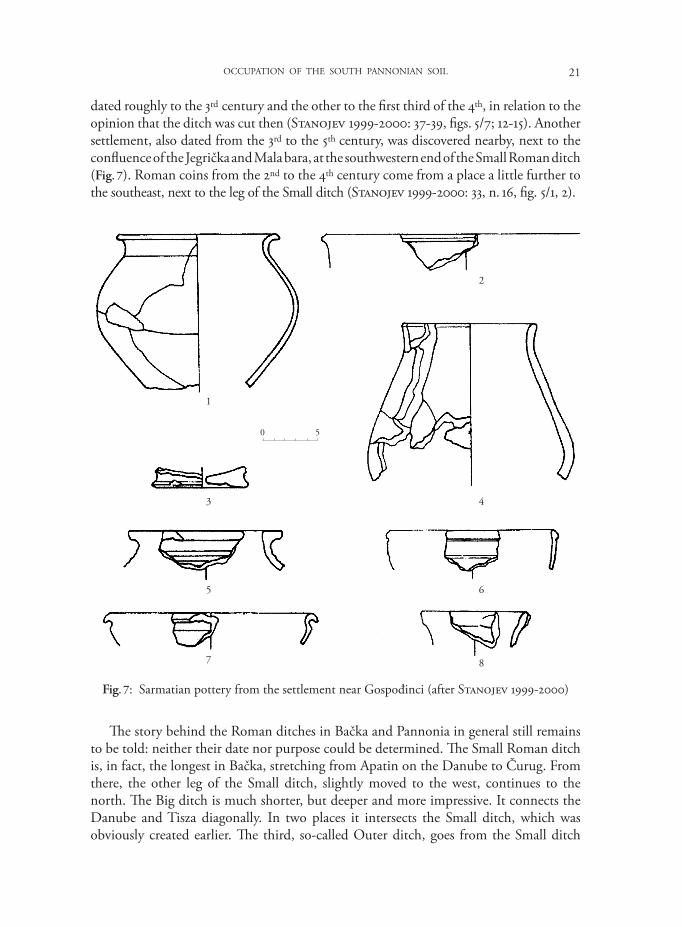
dated roughly to the 3rd century and the other to the first third of the 4th, in relation to the opinion that the ditch was cut then (Stanojev 1999-2000: 37-39, figs. 5/7; 12-15). Another settlement, also dated from the 3rd to the 5th century, was discovered nearby, next to the confluence of the Jegrička and Mala bara, at the southwestern end of the Small Roman ditch (Fig. 7). Roman coins from the 2nd to the 4th century come from a place a little further to the southeast, next to the leg of the Small ditch (Stanojev 1999- 2000: 33, n. 16, fig. 5/1, 2).
Fig. 7: Sarmatian pottery from the settlement near Gospođinci (after Stanojev 1999-2000)
1
3
5
7 8
6
4
2
0 5
The story behind the Roman ditches in Bačka and Pannonia in general still remains to be told: neither their date nor purpose could be determined. The Small Roman ditch is, in fact, the longest in Bačka, stretching from Apatin on the Danube to Čurug. From there, the other leg of the Small ditch, slightly moved to the west, continues to the north. The Big ditch is much shorter, but deeper and more impressive. It connects the Danube and Tisza diagonally. In two places it intersects the Small ditch, which was obviously created earlier. The third, so-called Outer ditch, goes from the Small ditch
22 IVAN BUGARSKI
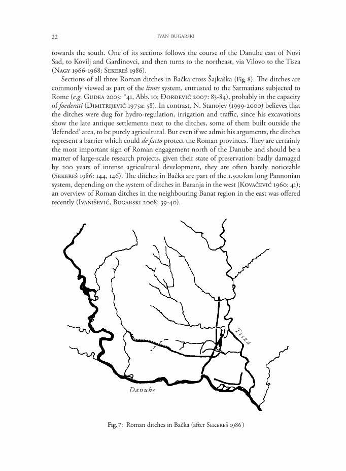
towards the south. One of its sections follows the course of the Danube east of Novi Sad, to Kovilj and Gardinovci, and then turns to the northeast, via Vilovo to the Tisza (Nagy 1966-1968; Sekereš 1986).
Sections of all three Roman ditches in Bačka cross Šajkaška (Fig. 8). The ditches are commonly viewed as part of the limes system, entrusted to the Sarmatians subjected to Rome (e.g. Gudea 2003: *41, Abb. 10; Đorđević 2007: 83-84), probably in the capacity of foederati (Dimitrijević 1975a: 58). In contrast, N. Stanojev (1999-2000) believes that the ditches were dug for hydro-regulation, irrigation and traffic, since his excavations show the late antique settlements next to the ditches, some of them built outside the ’defended’ area, to be purely agricultural. But even if we admit his arguments, the ditches represent a barrier which could de facto protect the Roman provinces. They are certainly the most important sign of Roman engagement north of the Danube and should be a matter of large-scale research projects, given their state of preservation: badly damaged by 200 years of intense agricultural development, they are often barely noticeable (Sekereš 1986: 144, 146). The ditches in Bačka are part of the 1.500 km long Pannonian system, depending on the system of ditches in Baranja in the west (Kovačević 1960: 41); an overview of Roman ditches in the neighbouring Banat region in the east was offered recently (Ivanišević, Bugarski 2008: 39-40).
Fig. 7: Roman ditches in Bačka (after Sekereš 1986 )
Danube
T i s z a
23OCCUPATION OF THE SOUTH PANNONIAN SOIL
III. Germanic settlement in Šajkaška
The ongoing wars with Rome and the appearance of other tribes, notably Germanic and Hunnic, destabilized centuries-long Sarmatian domination. The Sarmatians were defeated by Theodosius in 374 (Amm. Marc. XXIX.6), and as of 377, Huns, Goths and Alans penetrated the imperial provinces. The Goths and the Alans started to settle along the Danube limes (Dimitrijević 1975b: 69). However, the densely settled Sarmatians could not simply disappear from the region. D. Dimitrijević (1975b: 76-82) was most likely right to claim that the Sarmatians, despite their partial migration to the Empire, continued to be the majority in their area, while integrating the ethnic conglomerate led by the Huns. The author believed that the anonymous barbarians mentioned by Priscus in 448 (Prisci frg. 8) were Sarmatians (cf. Ivanišević, Bugarski 2008: 44). A different line of thinking, supported by historians (Barišić 1952) and archaeologists (Trifunović 1999-2000), identifies these barbarians as Slavs. The Slavs were not mentioned, however, among the participants in the battle of 454 on the Nedao rivulet, in which a coalition of tribes terminated the Hunnic state in Europe (Dimitrijević 1975b: 80, n. 34). They are first mentioned in the region in a much later historical source.
The Gepids, who led the coalition, expanded their territory to the Tisza river in the west. Srem and the area between the Drava and the Tisza were controlled by the Ostrogoths, who settled in Pannonia in 456 (Kiss 1996: 88-89, Abb. 1). It is not entirely clear who ruled the territory between the Danube and the Tisza, but the Middle Tisza region and Northern Bačka, or at least the 30 km wide stretch along the left bank of the Danube, from Csepel to Novi Sad (Kiss 2003: 185-186), seem to have been controlled by the Skirs from 454 to 470 (Dimitrijević 1975b: 81-82). Southern Bačka and Šajkaška could have remained under the Sarmatians, who seem only to have lost Singidunum to the Ostrogoths in 472, when their king was killed by Theodoric. The Sarmatians then joined the Gepids in the 488 battle against the Ostrogoths. In the course of time, they were gradually assimilated and disappeared from the written sources. Peace ended only with the arrival of the Lombards in 546, who clashed with the Gepids and defeated them definitively in 567 (Dimitrijević 1975b: 82-83).
Thus, there were two phases of Germanic presence in the region – first under Hunnic domination and then under the Gepids, with 454 as a turning point. Germanic findings are scarce in Šajkaška in both periods.
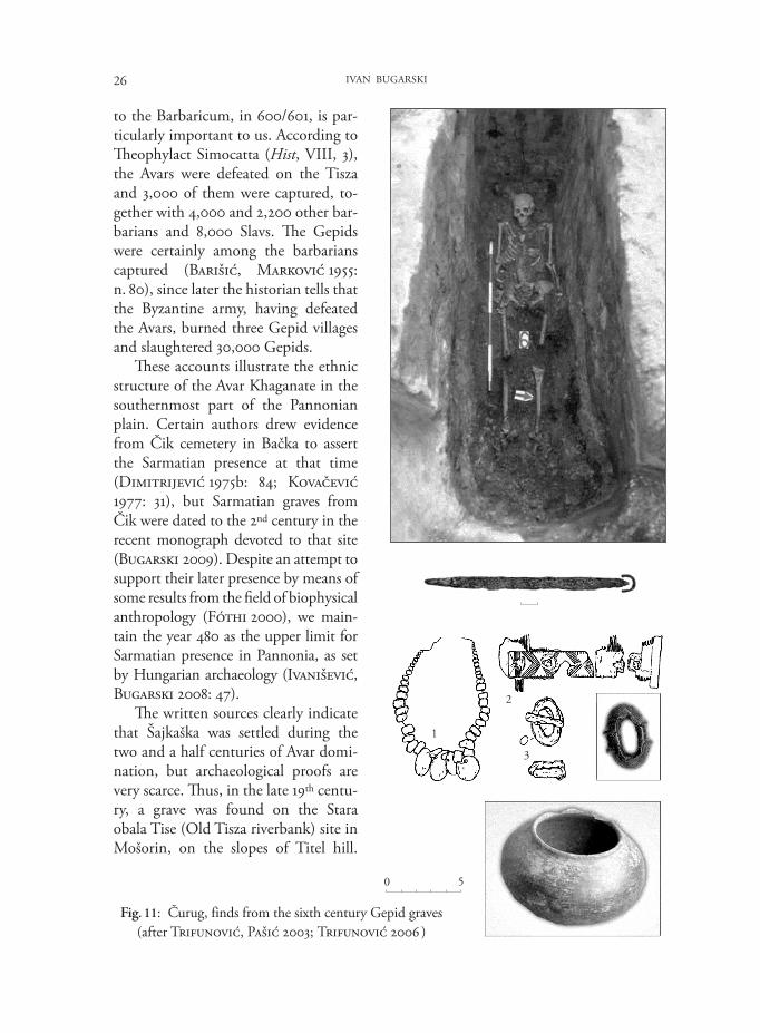
The survey of 1975 does not list a single find from the first period (Dimitrijević 1975b: 72). Only the recent excavations at the Stari Vinogradi site in Čurug revealed a few relevant graves, several others being ruined (Fig. 3 : 2). Three south-north oriented warriors’ graves were dated to the 4th, possibly, to the early 5th century (Trifunović, Pašić 2003: 278-279, fig. 13; Trifunović 2006). The upper limit was based on the dating of a fibula (Trifunović 2006: Photo 145), which finds the closest analogy in the late Sarmatian cemetery Subotica–Verušić, in a grave with a broken spear (Sekereš 1998: 112, 118-119, T. XX/2). The fibulae from Čurug and Subotica seem to represent a later, barbarized variant of the Roman armbrust fibulae from the second half of the 3rd and the 4th centuries (Peškař 1972: 125-126, Tf. 43). Fairly similar findings from the Hunnic domination period come from Levice cemetery in
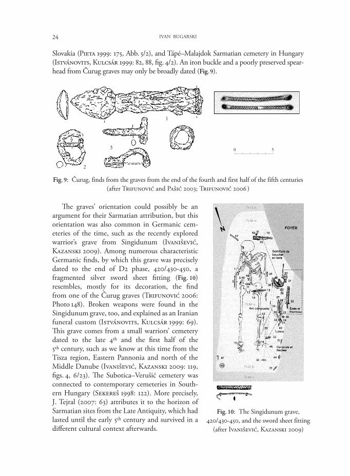
24 IVAN BUGARSKI
Slovakia (Pieta 1999: 175, Abb. 5/2), and Tápé–Malajdok Sarmatian cemetery in Hungary (Istvánovits, Kulcsár 1999: 82, 88, fig. 4/2). An iron buckle and a poorly preserved spear-head from Čurug graves may only be broadly dated (Fig. 9).
Fig. 9: Čurug, finds from the graves from the end of the fourth and first half of the fifth centuries (after Trifunović and Pašić 2003; Trifunović 2006 )
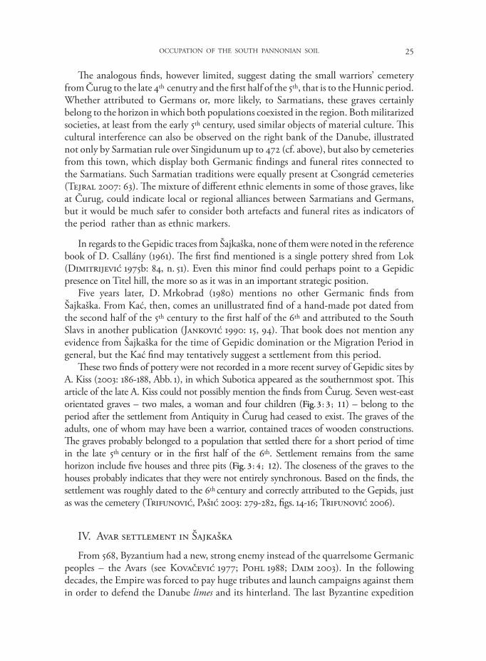
Fig. 10: The Singidunum grave, 420/430-450, and the sword sheet fitting
(after Ivanišević, Kazanski 2009)
0 5
2
3
1
The graves’ orientation could possibly be an argu ment for their Sarmatian attribution, but this orientation was also common in Germanic cem-e teries of the time, such as the recently explored warrior’s grave from Singidunum (Ivanišević, Kazan ski 2009). Among numerous characteristic Germanic finds, by which this grave was precisely dated to the end of D2 phase, 420/430-450, a frag mented silver sword sheet fitting (Fig. 10) resembles, mostly for its decoration, the find from one of the Čurug graves (Trifunović 2006: Photo 148). Broken weapons were found in the Singidunum grave, too, and explained as an Iranian funeral custom (Istvánovits, Kulcsár 1999: 69). This grave comes from a small warriors’ cemetery dated to the late 4th and the first half of the 5th century, such as we know at this time from the Tisza region, Eastern Pannonia and north of the Middle Danube (Ivanišević, Kazanski 2009: 119, figs. 4, 6/23). The Subotica–Verušić cemetery was connected to contemporary cemeteries in South-ern Hungary (Sekereš 1998: 122). More precisely, J. Tejral (2007: 63) attributes it to the horizon of Sarmatian sites from the Late Antiquity, which had lasted until the early 5th century and survived in a different cultural context afterwards.
25OCCUPATION OF THE SOUTH PANNONIAN SOIL
The analogous finds, however limited, suggest dating the small warriors’ cemetery from Čurug to the late 4th cenutry and the first half of the 5th, that is to the Hunnic period. Whether attributed to Germans or, more likely, to Sarmatians, these graves certainly belong to the horizon in which both populations coexisted in the region. Both militarized societies, at least from the early 5th century, used similar objects of material culture. This cultural interference can also be observed on the right bank of the Danube, illustrated not only by Sarmatian rule over Singidunum up to 472 (cf. above), but also by cemeteries from this town, which display both Germanic findings and funeral rites connected to the Sarmatians. Such Sarmatian traditions were equally present at Csongrád cemeteries (Tejral 2007: 63). The mixture of different ethnic elements in some of those graves, like at Čurug, could indicate local or regional alliances between Sarmatians and Germans, but it would be much safer to consider both artefacts and funeral rites as indicators of the period rather than as ethnic markers.
In regards to the Gepidic traces from Šajkaška, none of them were noted in the reference book of D. Csallány (1961). The first find mentioned is a single pottery shred from Lok (Dimitrijević 1975b: 84, n. 51). Even this minor find could perhaps point to a Gepidic presence on Titel hill, the more so as it was in an important strategic position.
Five years later, D. Mrkobrad (1980) mentions no other Germanic finds from Šajkaška. From Kać, then, comes an unillustrated find of a hand-made pot dated from the second half of the 5th century to the first half of the 6th and attributed to the South Slavs in another publication (Janković 1990: 15, 94). That book does not mention any evidence from Šajkaška for the time of Gepidic domination or the Migration Period in general, but the Kać find may tentatively suggest a settlement from this period.
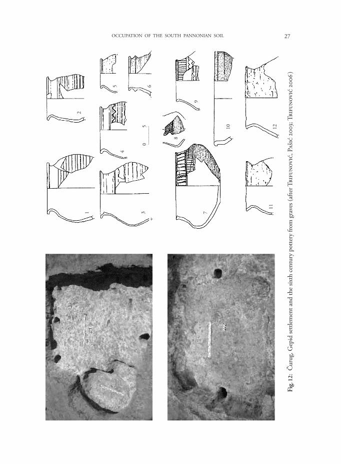
These two finds of pottery were not recorded in a more recent survey of Gepidic sites by A. Kiss (2003: 186-188, Abb. 1), in which Subotica appeared as the southernmost spot. This article of the late A. Kiss could not possibly mention the finds from Čurug. Seven west-east orientated graves – two males, a woman and four children (Fig. 3 : 3 ; 11) – belong to the period after the settlement from Antiquity in Čurug had ceased to exist. The graves of the adults, one of whom may have been a warrior, contained traces of wooden constructions. The graves probably belonged to a population that settled there for a short period of time in the late 5th century or in the first half of the 6th. Settlement remains from the same horizon include five houses and three pits (Fig. 3 : 4 ; 12). The closeness of the graves to the houses probably indicates that they were not entirely synchronous. Based on the finds, the settlement was roughly dated to the 6th century and correctly attributed to the Gepids, just as was the cemetery (Trifunović, Pašić 2003: 279-282, figs. 14-16; Trifunović 2006).
IV. Avar settlement in Šajkaška
From 568, Byzantium had a new, strong enemy instead of the quarrelsome Germanic peoples – the Avars (see Kovačević 1977; Pohl 1988; Daim 2003). In the following decades, the Empire was forced to pay huge tributes and launch campaigns against them in order to defend the Danube limes and its hinterland. The last Byzantine expedition
26 IVAN BUGARSKI
to the Barbaricum, in 600/601, is par-ticularly important to us. According to Theophylact Simocatta (Hist, VIII, 3), the Avars were defeated on the Tisza and 3,000 of them were captured, to-geth er with 4,000 and 2,200 other bar-barians and 8,000 Slavs. The Gepids were certainly among the barbarians captured (Barišić, Marković 1955: n. 80), since later the historian tells that the Byzantine army, having defeated the Avars, burned three Gepid villages and slaughtered 30,000 Gepids.
These accounts illustrate the ethnic structure of the Avar Khaganate in the southernmost part of the Pannonian plain. Certain authors drew evidence from Čik cemetery in Bačka to assert the Sarmatian presence at that time (Dimi trijević 1975b: 84; Kovačević 1977: 31), but Sarmatian graves from Čik were dated to the 2nd century in the recent monograph devoted to that site (Bugarski 2009). Despite an attempt to support their later presence by means of some results from the field of biophysical anthropology (Fóthi 2000), we main-tain the year 480 as the upper limit for Sarmatian presence in Pannonia, as set by Hungarian archaeology (Ivanišević, Bugarski 2008: 47).
The written sources clearly indicate that Šajkaška was settled during the two and a half centuries of Avar domi-nation, but archaeological proofs are very scarce. Thus, in the late 19th centu-ry, a grave was found on the Stara obala Tise (Old Tisza riverbank) site in Mošorin, on the slopes of Titel hill.
Fig. 11: Čurug, finds from the sixth century Gepid graves (after Trifunović, Pašić 2003; Trifunović 2006 )
1
2
3
0 5
27OCCUPATION OF THE SOUTH PANNONIAN SOIL
Fig.
12:
Čur
ug, G
epid
settl
emen
t and
the s
ixth
cent
ury
potte
ry fr
om g
rave
s (af
ter T
rifu
novi
ć, P
ašić
200
3; T
rifu
novi
ć 20
06 )
12
45 6
3
8
9
7
10 1211
05

28 IVAN BUGARSKI
While no inventory is available, a pair of gold earrings was mentioned, possibly from the 7th century, or of an even later date according to a recent comment (ADAM 2002: 247-248). It has been suggested that four other graves were found on the same occasion (Dimitrijević, Kovačević, Vinski 1962: 49; Dimitrijević 1975b: 87, n. 61).
From a male grave found in Titel before World War II (Dimitrijević, Kovačević, Vinski 1962: 62, figs. 1, 2, T. XXIV/3; Dimitrijević 1975b: 92), a cast bronze strap-end and a buckle with a fitting of bronze sheet have been preserved, together with a wheel made pot (Fig. 13). Following J. Zábojník (1991) and É. Garam (1995), the grave may be dated to 720-750. Another published strap-end from Titel, found together with some ’Avaroslavic’ objects (Manojlović 1969-1970: 305-306, fig. 22), is of the same date.
S. Nagy (1971: 190, n. 29) noted that in 1968 some Avar graves were discovered in Đurđevo, on Nikolić (Surkin) salaš site, but D. Dimitrijević (1975b) does not mention these graves, nor is there any other mention of them in the more recent literature.
A warrior’s grave from Kovilj contained parts of a horse harness (but no skeleton), as well as a sabre, perforated arrowheads, belt or harness mounts, snuffle-bits and stirrups. Only the weapons were illustrated by D. Dimitrijević (1975b: 92-93, n. 79), whose dating of the grave to the 8th century and its Avar attribution were accepted by many (Mrkobrad 1980: 98, n. 656; Takács 2000b: 469; Bugarski 2008: 447). Some reservations were voiced, however, in the reference catalogue of Avar sites (ADAM 2002: 210); it has also been noted that bent sabres may be found in early Hungarian graves (Dimitrijević 1975b: n. 79).
Finaly, I refrain from comment on two late Avar graves listed by D. Dimitrijević (1975b: 92- 93) in Čenej–Rivica, which is outside the Šajkaška region (cf. Dimitrijević, Kovačević, Vinski 1962: 53-54; Takács 2000b: 469; ADAM 2002: 265; Bugarski 2008: 446).
Fig. 13: Finds from the Titel grave, 720-750 (after Dimitrijević, Kovačević, Vinski 1962)
0 5
29OCCUPATION OF THE SOUTH PANNONIAN SOIL
V. Conclusion
The Sarmatians left considerably more traces in Šajkaška than the Germans and the Avars, no doubt due to the fact that they had more time and possibilities to create a denser network of settlements. The same was noticed for the Migration Period heritage of the neighbouring western Banat region, where settlements were also formed according to the geomorphological determinants (Ivanišević, Bugarski 2008: 56-59). The Sarmatian period was also a time of a rapid population growth. Another similar climax was reached in the Late Avar period (Sekereš 1986: 144), but there have been so far few proofs of it in Šajkaška.
No new systematic explorations in Šajkaška came to complete the survey of D. Dimi-trijević. N. Stanojev’s and S. Trifunović’s results should be pointed out, however, in particular on the site of Stari vinogradi in Čurug, which revealed what seems to be a Late Sarmatian and Gepidic settlement. Future excavations will probably produce evidence of Avar presence at the site, too, the more so since traces of more recent settlements have been recorded (Trifunović, Pašić 2003: 282-287, figs. 17-19) in this excellent geographical position, provided with the best chernozem. Near Čurug end the legs of both main ’Roman’ ditches in Bačka terminate, which also testifies its important position.
Titel hill is a particularly important geographical unit since there was a Roman stronghold there for a long period, guarding the provinces south of the Danube, as well as the northern province of Dacia during its existence (107-271).
The confluence of the Tisza and the Danube is commonly considered as the western border of the province of Dacia (cf. Gudea 2003: *41; Oltean 2007: fig. 1.1). The reference article on the province (Gudea 1998: *14) cautions, however, that the southwestern borderline was not sufficiently clear. M. Mirković (2002: 762) suggests that the ’swampy and not inhabited’ zone in the east, between the Tisza and the Lederata-Berzobis road, was outside the provincial and imperial frontier, ’but not necessarily beyond Roman control’. Yet, the area in question was not uninhabited. This is made clear by the recently published map of Sarmatian settlements and cemeteries in western Banat (Ivanišević, Bugarski 2008: fig. 1), or by the map published by S. Barački (1975) in his catalogue of the Sarmatian jewellery from the Banat region. Roman finds come from some 25 sites in southern Banat, dated to the period of the occupation of Dacia (Barački 1991: 28).
Further on, the above-mentioned monuments from Titel and Vilovo clearly point to Roman presence on the hill. Therefore, M. Mirković’s conclusion (1981: 89) that from the closing decades of the 2nd century the area between the Tisza and the Danube was used by Sarmatians and other populations as a corridor for incursions in lower Pannonia, northeastern Dalmatia and Upper Moesia, may be applied with certainty only to the rest of Bačka, including the western part of Šajkaška. Contra Acumincum, however, as well as Onagrinum in the west, present-day Begeč, did not represent a core out of which Roman towns developed (Brukner 1990: 203). The Titel fort could also have served for protection of the communication routes leading from Acumincum to
30 IVAN BUGARSKI
Dacia (Mirković 2002: 759, fig. 2), and it is likely that the authors who set the border of the province on the Tisza were right.
During the Migration Period, this area was certainly outside the formal reach of the Empire. A single Gepidic pottery shred and sporadic Avar finds known so far do not testify to any significant settling of Titel hill in that period, but one may expect new finds, since 10th-11th centuries cemeteries have been observed in Titel (Takács 2000b: 470) and Mošorin (Stanojev 1989: 6, 59-60; Takács 2000b: 470), as well as medieval settlements in Mošorin (Stanojev 1996: 101-107). Titel was the only known town in Šajkaška in the 14th century (Đere 1988: 110-111), which confirms the importance of its position.
The only place in Šajkaška with no findings from Antiquity and the Migration Period is Budisava, which is strange since this village is situated in one of the most flood-protected places in Šajkaška and on fertile chernozem. Such features must have been of decisive importance in choosing a settlement location, so one may expect with certainty that future excavations in Budisava will be fruitful. The same is true of Đurđevo.
To conclude, the proposed reconstruction of the Šajkaška landscape in Antiquity and the Migration Period argues against the idea of nomadism being the way of life in this region. It may be stated that the basis of the economy was primarily agriculture, hunting and fishing. Food surpluses were traded; we know of a concession of emperor Marcus Aurelius to the Jazyges, which let them visit Roman marketplaces (Dimitrijević 1975a: 40). At that time and in the Migration Period, the inhabitants of Šajkaška certainly earned their living by booty and also by tributes. Regardless of whether their victims were the other ’barbarians’ or the Empire, that kind of war economy is not exclusively nomadic either.
Bibliography
ADAM 2002 : J. Szentpéteri (Hrsg.), Archäologische Denkmäler der Awarenzeit in Mitteleuropa, Budapest 2002.
Ammianus Marcellinus : Ammiani Marcellini Rerum gestarum libri qui supersunt, ed. W. Seyfarth, Leipzig 1978.
Babić N., Parabućski S. 1971 : Prikaz vegetacije Šajkaške, in : Šajkaška 1971, 114-139.
Barački S. 1975 : Nakit Sarmata u Banatu, sa pregledom sarmatskih nalazišta (katalog uz izložbu), Vršac 1975.
Barački S. 1991 : Rimsko-provincijsko doba, seoba naroda i rani srednji vek, in : G. Miletić (ed.), Arheološki nalazi Jugoistočnog Banata, Vršac 1991, 28-32.
Barišić F. 1952 : Prisk kao izvor za najstariju istoriju južnih Slovena, in : G. Ostrogorsky (ed.), Zbornik radova XXI : Vizantološki institut Knj. 1, Beograd 1952, 52-63.
Barišić F., Marković M. 1955: Teofilakt Simokata, in : G. Ostrogorsky (ed.), Vizantiski izvori za istoriju naroda Jugoslavije I, Beograd 1955, 103-126.
31OCCUPATION OF THE SOUTH PANNONIAN SOIL
Brukner O. 1990 : Rimski nalazi u jugoslovenskom delu Barbarikuma – Bačka i Banat, Arheološki vestnik 41. Šašlov zbornik, 1990, 199-216.
Bugarski I. 2008 : The geomorphological matrix as a starting point for determining the position of Avar-time settlements in Pannonia: the example of the Bačka Region, Archäologisches Korrespondenzblatt 38/3, 2008, 437-455.
Bugarski I. 2009 : Nekropole iz doba antike i ranog srednjeg veka na lokalitetu Čik, Beograd 2009.
Bukurov B. 1971 : Geomorfologija Šajkaške, in : Šajkaška 1971, 53-76.Csallány D. 1961 : Archäologische Denkmäler der Gepiden im Mitteldonaubecken (454-
568 u. Z.), Budapest 1961. Ćurčić S., Đuričić J. 1994 : Reljef kao faktor položaja i formiranja morfoloških kara kte-
ristika vojvođanskih naselja, Zbornik Matice Srpske za Društvene Nauke 97, 1994, 147-178.Daim F. 2003 : Avars and Avar archaeology: an introduction, in : H.-W. Goetz,
J. Jarnut, W. Pohl (eds.), Regna and Gentes. The relationship between Late Antique and Early Medieval peoples and kingdoms in the transformation of the Roman world, Leiden – Boston 2003, 463-570.
Dautova-Ruševljan V. 1974-1978 : Rimski novac iz Gardinovaca, Rad vojvođanskih muzeja 23-24, 1974-1978, 63-66.
Dautova-Ruševljan V. 1990 : Dosadašnji rezultati istraživanja i problemi pri pro uča-vanju sarmatske kulture u Vojvodini, Rad vojvođanskih muzeja 32, 1990, 81-94.
Dautova-Ruševljan V., Vujović M. 2006 : Rimska vojska u Sremu, Novi Sad 2006.Đere K. 1988 : Neke odlike srednjovekovne urbane mreže Vojvodine, Zbornik radova
Prirodno-matematičkog fakulteta, Instituta za Geografiju u Novom Sadu 18, 1988, 103-124.Dimitrijević D. 1975a : Sarmati i Rimljani, in : S. Gavrilović (ed.), Šajkaška. Istorija. 1,
Novi Sad 1975, 34-67.Dimitrijević D. 1975b : Doba velikih migracija, in : S. Gavrilović (ed.), Šajkaška.
Istorija. 1, Novi Sad 1975, 68-96.Dimitrijević D. 1996 : Pristaništa Classis Flaviae Pannonicae na Basijanskom sektoru
Dunava, Zbornik Matice srpske za istoriju 54, 1996, 7-38.Dimitrijević D., Kovačević J., Vinski Z. 1962 : Seoba naroda: arheološki nalazi jugo-
slovenskog Podunavlja, Zemun 1962.Đorđević M. 1990 : Tri nova sarmatska naselja u severnoj Bačkoj, Glasnik Srpskog
arheološkog društva 6, 1990, 119-124.Đorđević M. 2007 : Arheološka nalazišta rimskog perioda u Vojvodini, Beograd 2007.Dušanić S. 1965 : Tri epigrafska priloga, Živa antika 15/1, 1965, 85-108.Dušanić S. 1967 : Novi i revidirani rimski natpisi iz istočnog Srema, Živa antika 17,
1967, 195-215.Dušanić S. 1968 : Rimska vojska u istočnom Sremu, Zbornik Filozofskog fakulteta 10/1.
Spomenica Vase Čubrilovića, 1968, 87-113.
32 IVAN BUGARSKI
Fóthi E. 2000 : Anthropological conclusions of the study of Roman and Migration periods, Acta Biologica Szegediensis 44, 2000, 87-94.
Garam É. 1995 : Das awarenzeitliche Gräberfeld von Tiszafüred, Budapest 1995.Geomorphological map 2005 : M. Košćal, Lj. Menković, M. Mijatović, M. Knežević
(eds.), Geomorfološka karta Autonomne Pokrajine Vojvodine = Geomorphological map of the Autonomous Region of Vojvodina, Beograd 2005.
Gudea N. 1998 : Der dakische Limes: Materialien zu seiner Geschichte, Jahrbuch des Römisch-Germanisches Zentralmusuem 44, 1998, 497-609.
Gudea N. 2003 : Die Nordgrenze der Provinz Moesia Superior. 86-275 n. Chr. Mate-rialien zu ihrer Geschichte, Jahrbuch des Römisch-Germanisches Zentralmusuem 48, 2003, 337-454.
Heinrich-Tamaska O. 2008 : Bemerkungen zur Landschafts- und Raumstruktur auf dem Gebiet der “Keszthely-Kultur”, in : J. Bemmann, M. Schmauder (Hrsg.), Kulturwandel in Mitteleuropa, Langobarden – Awaren – Slawen, Akten der Internationalen Tagung in Bonn vom 25. bis 28. Februar 2008, Bonn 2008, 431-447.
Istvánovits E., Kulcsár V. 1999 : Sarmatian and Germanic people at the Upper Tisza Region and South Alföld at the beginning of the Migration Period, in : J. Tejral, C. Pilet, M. Kazanski (éd.), L’Occident romain et l’Europe centrale au début de l’époque des Grandes Migrations (Spisy Arch. Ústavy AV ČR Brno 13), Brno 1999, 67-94.
Ivanišević V., Bugarski I. 2008 : Western Banat during the Great Migration Period, in : B. Niezabitowska-Wiśniewska, M. Juściński, P. Łuczkiewicz, S. Sadowski (eds.), The turbulent epoch. 2, New materials from the Late Roman period and the Migration Period (Monumenta Studia Gothica V), Lublin 2008, 39-61.
Ivanišević V., Kazanski M. 2009 : Nouvelle nécropole des Grandes migrations de Singidunum, Starinar 57, 2009, 115-137.
Janković M., Janković Đ. 1990 : Sloveni u jugoslovenskom Podunavlju, Beograd 1990.Jovanović A. 2004 : Rimska posuda sa medaljonima iz Čuruga, Glasnik Srpskog
arheološkog društva 20, 2004, 207-215.Jovanović A. 2005 : Archaeological notes of the fortifications from Pannonia Secunda,
in : M. Mirković (ed.), Römische Städte und Festungen an der Donau, Akten der Regionalen Konferenz, Beograd, 16-19 Oktober 2003, Beograd 2005, 83-87.
Kiss A. 1996 : Die Osthrogoten in Pannonien (456-473) aus archäologischer Sicht, Zalai Múzeum 6, Zalaegerszeg 1996, 87-90.
Kiss A. 2003 : Archäologische und numismatische Angaben zur Siedlungsgeschichte des Donau–Theiß–Zwischenstromlandes in der zweiten Hälfte des 5. und der ersten Hälfte des 6. Jahrhunderts, in : R. Bunardžić, Ž. Mikić (eds.), Spomenica Jovana Kovačevića, Beograd 2003, 185-193.
Kory R. W. 2002 : Avar settlements: a challenge to archaeological research, in : H. C. Gü-zel, C. C. Oğuz, O. Karatay (eds.), The Turks. 1, Early Ages, Ankara 2002, 607-616.
Košćal M., Menković Lj. 2005 : Tumač za geomorfološku kartu 1:200 000, Beograd 2005.
33OCCUPATION OF THE SOUTH PANNONIAN SOIL
Kovačević J. 1960 : Varvarska kolonizacija južnoslovenskih oblasti, Novi Sad 1960.Kovačević J. 1977 : Avarski kaganat, Beograd 1977.Kukin A., Marinović Đ. 1971 : Ekonomsko-geološke karakteristike Šajkaške, in : Šajkaška
1971, 22-31.Lindner R. P. 1981 : Nomadism, horses and Huns, Past and Present 92, 1981, 3-19.Manojlović M. 1969-1970 : Poklonjeni i otkupljeni fondovi u zbirci Arheološkog
odeljenja Vojvođanskog muzeja, Rad vojvođanskih muzeja 18-19, 1969-1970, 295-309.Marjanov M. 1971 : Vode Šajkaške, in : Šajkaška 1971, 77-94.Miljković N. 1971 : Zemljišta Šajkaške, in : Šajkaška 1971, 32-52.Mirković M. 1981 : Centralne balkanske oblasti u doba poznog carstva, in : S. Ćirković
(ed.), Istorija srpskog naroda 1, Beograd 1981, 89-105.Mirković M. 2002 : Deserted forts: the Moesian limes after the conquest of Dacia, in :
Ph. Freeman, J. Bennett, Z. T. Fiema, B. Hoffmann (eds.), Limes XVIII. Proceedings of the XVIIIth International Congress of Roman Frontier Studies held in Amman, Jordan (September 2000) (BAR International Series 1084, 2), Oxford 2002, 757-764.
Mócsy A. 1977 : Die Einwanderung der Jazygen, Acta antiqua Academiae Scientiarum Hungaricae 25, 1977, 439-466.
Mrkobrad D. 1980 : Arheološki nalazi seobe naroda u Jugoslaviji, Beograd 1980.Nagy S. 1966-1968 : Izveštaj o rezultatima istraživanja uzdužnih šančeva na području
Vojvodine, Rad vojvođanskih muzeja 15-17, 1966-1968, 103-108.Nagy S. 1971 : Nekropola iz ranog srednjeg veka u ciglani Polet u Vrbasu, Rad
vojvođanskih muzeja 20, 1971, 187-268.Oltean I. A. 2007 : Dacia: landscape, colonisation and Romanisation, London – New
York 2007.Peškař I. 1972 : Fibeln aus der römischen Kaiserzeit in Mähren, Praha 1972.Pieta K. 1999 : Anfänge der Völkerwanderungszeit in der Slowakei (Fragestellungen
der zeitgenössischen Forschung), in : J. Tejral, C. Pilet, M. Kazanski (éd.), L’Occident romain et l’Europe centrale au début de l’époque des Grandes Migrations (Spisy Arch. Ústavy AV ČR Brno 13), Brno 1999, 171-189.
Pohl W. 1988 : Die Awaren. Ein Steppenwolk in Mitteleuropa 567-822 n. Chr., München 1988.Priscus : Prisci Fragmenta (transl. F. Barišić), in : G. Ostrogorsky (ed.), Vizantiski
izvori za istoriju naroda Jugoslavije I, Beograd 1955, 7-16.Šajkaška 1971 : B. Bukurov (ed.), Šajkaška. Priroda kraja, Novi Sad 1971.Sekereš L. 1986 : Problem takozvanih Rimskih šančeva u Bačkoj, in : P. Medović (ed.),
Materijali XXII. Odbrambeni sistemi u praistoriji i antici na tlu Jugoslavije, Referati XII kongresa arheologa Jugoslavije – Novi Sad 1984, Novi Sad 1986, 144-152.
Sekereš A. 1998 : Sarmatska nekropola Subotica-Verušić, Rad muzeja Vojvodine 40, 1998, 107-147.
34 IVAN BUGARSKI
Slavnić M. 1952 : Nekropola u Čurugu, Muzeji 7, 1952, 46-54.Soil map 1971 : N. Miljković, M. Janković, Pedološka karta Šajkaške = Soil map of
Shaykashka, in : Šajkaška 1971.Soproni S. 1969 : Limes Sarmatiae, Móra Ferenc Múzeum Ėvkönyve 2, 1969, 117-135.Stanojev N. 1989 : Nekropole X-XV veka u Vojvodini, Novi Sad 1989.Stanojev N. 1996 : Srednjovekovna naselja u Vojvodini, Novi Sad 1996.Stanojev N. 1999-2000 : “Rimski šančevi”: vodoprivredni sistem Panonske nizije, Rad
muzeja Vojvodine 41-42, 1999-2000, 29-43.Takács M. 2000a : Népvándorláskor-kutatások Kis-Jugoszláviában, az 1990-es években,
Hadak Útján. A népvándorlás kor fiatal kutatóinak konferenciája, Szeged 2000, 393-414.Takács M. 2000b : Einige Aspekte der Siedlungsgeschichte des südlichen Drittels des
Donau-Theiß-Zwischenstromlandes von der awarischen Landnahme bis zum Ende des 11. Jahrhunderts, Acta archaeologica Academiae scientiarum Hungaricae 51, 2000, 457-472.
Tejral J. 2007 : Das Hunnenreich und die Identitätsfragen der barbarischen “gentes” im Mitteldonauraum aus der Sicht der Archäologie, in : J. Tejral (Hrsg.), Barbaren im Wandel: Beiträge zur Kultur- und Identitäts umbildung in der Völkerwanderungszeit (Spisy Arch. Ústavy AV ČR Brno 26), Brno 2007, 55-119.
Theophylact Simocatta : The History of Theophylact Simocatta, ed. M. & M. Whitby, Oxford 1986.
Trifunović S. 1999-2000 : Naselja Limiganata i Slovena u Banatu i Bačkoj, Glasnik Srpskog arheološkog društva 15-16, 1999-2000, 43-106.
Trifunović S. 2006 : Arheološko nalazište Stari vinogradi = Archaeological Site Čurug – Stari Vinogradi, Backa Region, Vojvodina Province, Serbia, Novi Sad – Beograd 2006 [CD-ROM].
Trifunović S., Pašić I. 2003 : “Stari vinogradi” u Čurugu – višeslojno arheološko nalazište, Glasnik Srpskog arheološkog društva 19, 2003, 263-290.
Vaday A. 2001 : Militia inermis, militia armata. Bemerkungen zur Frage des Limes Sarmatiae, Slovenská Archeológia 49, 2001, 249-276.
Veselinović R. L. 1953 : Starosrpsko naselje na Bosaništu kod Mošorina u Bačkoj (prilog istoriji materijalne kulture Južnih Slovena X-XII veka), Rad vojvođanskih muzeja 2, 1953, 5-58.
Vilotijević D. 1965 : Nove zemlje, Žabalj – višeslojno praistorijsko nalazište, Arheološki pregled 7, 1965, 31-32.
Vujević P. 1939 : Geopolitički i fizičko–geografski prikaz Vojvodine, in : D. J. Popović (ed.), Vojvodina. 1, Novi Sad 1939, 1-28.
Zábojník J. 1991 : Seriation von Gürtelbeschlaggarnituren aus dem Gebeit der Slowakei und Österreichs (Beitrag zur Chronologie der Zeit des Awarischen Kaganats), in : Z. Čilinská (ed.), K problematike osídlenia Stredodunajskej oblasti vo včasnom stredoveku, Nitra 1991, 219-323.