mitigation strategy report - · pdf filemitigation strategy report ... decrease in the area of...
TRANSCRIPT

Mitigation Strategy Report
FOR THE PROPOSED FAIRVIEW TERMINAL PHASE II EXPANSION PROJECT IN PRINCE RUPERT, BC
August 22, 2011
Submitted To: Canadian Environmental Assessment Agency 805 – 1550 Alberni Street Vancouver, BC V6G 1A5 Submitted By: Prince Rupert Port Authority 200 – 215 Cow Bay Road Prince Rupert, BC V8J 1A2 and Canadian National Railway Company 13477 – 116th Avenue Surrey, BC V3R 6W4
MITIGATION STRATEGY REPORT FOR THE PROPOSED FAIRVIEW TERMINAL PHASE II EXPANSION PROJECT IN PRINCE RUPERT, BC
i
Executive Summary
Introduction
The Prince Rupert Port Authority (PRPA) and the Canadian National Railway Company (CN) are proposing to
expand Fairview Terminal at Prince Rupert, BC. The proposed Project consists of the construction and
operation of a wharf expansion and expanded container and intermodal facilities at the existing Fairview
Terminal, on Kaien Island in Prince Rupert, BC. As part of the Project, CN plans to construct two rail sidings
and a maintenance road adjacent to the existing mainline between Fairview Terminal and Zanardi Rapids,
and a wye near the existing CN bunkhouse. PRPA is also proposing to construct a Port-dedicated access
road between the terminal and northern Ridley Island, to alleviate the need for trucks to travel through the
downtown core of Prince Rupert to reach the terminal or to access Ridley Island.
On November 27, 2009, PRPA and CN submitted an Environmental Impact Statement (EIS) entitled
Environmental Impact Statement Fairview Terminal Phase II Expansion Project including Kaien Siding to the
Canadian Environmental Assessment Agency (the CEA Agency). The EIS was developed by the proponents
to support preparation of a Comprehensive Study Report (CSR) as required for the Project under the
Canadian Environmental Assessment Act (CEAA). The Responsible Authorities (RAs) for the Project under
the CEAA process are Fisheries and Oceans Canada (DFO), Environment Canada (EC) and the Canadian
Transportation Agency (CTA). The PRPA, as a Canada Port Authority is also responsible for conducting an
environmental assessment under the Canada Port Authorities Environmental Assessment Regulations.
Review of the EIS by Government, First Nations and the proponents resulted in Project re-design that has
incorporated some important additional environmental mitigation elements. The key aspects of this re-design
and the environmental implications are presented in this Mitigation Strategy Report (the Report).
Key concerns raised with respect to the original Project design and the 2009 EIS submission included:
disposal of waste sediment and terrestrial overburden at Brown Passage
loss of freshwater and intertidal habitat in and around Casey Creek
loss of wetland habitat in and around a tidal lagoon marsh
loss of a seepage swamp
The intent of this the Report is to present the CEA Agency, RAs and First Nations with an overview of the
revised Project design and environmental implications including predicted residual environmental effects.
This report is intended to be a bridging document between the EIS and the CSR, which is to be submitted
subsequently.

MITIGATION STRATEGY REPORT FOR THE PROPOSED FAIRVIEW TERMINAL PHASE II EXPANSION PROJECT IN PRINCE RUPERT, BC
ii
2011 Mitigative Redesign
Changes to the Project plan intended to mitigate the key concerns include:
reducing the terrestrial portion of the terminal from 33 ha to 15.7 ha
reducing the overall amount of material requiring disposal at sea from 1,300,000 m3 to
180,000 m3
reducing the extent of disturbance in and around Casey Creek
eliminating the impact to 3,374 m2 of tidal marsh lagoon at the location of the wye
re-directing truck traffic away from the downtown core of Prince Rupert
The Fairview Terminal Phase II Expansion Project will be constructed in two stages: a Northern Expansion
(―Stage 1‖) and a Southern Expansion (―Stage 2‖). The Northern Expansion was not included in the 2009 EIS
submission, but is addressed within this Report. It is anticipated that the road between the terminal and Ridley
Island, will be constructed during Stage 1 (with the northern terminal expansion). The CN sidings and wye will
be constructed as part as Stage 1, or when deemed necessary. All disposal at sea activities are associated
with Stage 2 and will not be undertaken until after 2015. The staged approach allows for consideration of
economies and traffic volumes prior to construction of full build-out, and minimizes the level of disturbance to
the environment (e.g., construction effects on air quality and noise) at any given time. Construction of Stage 1
is expected to commence in spring/summer of 2012, following completion of the environmental assessment
(EA) and permitting processes. The EA process and this Report address potential environmental effects
associated with both Stage 1 and Stage 2 (full build out).
Anticipated efficiencies related to terminal operations mean that a greater number of vessels are expected to
call on the terminal under full build out as compared to the 2009 EIS submission. It is expected that under full
build out (completion of Stages 1 and 2) between 10 and 14 vessels will call on the terminal per week. Under
full build out it is anticipated that there will be 10 train movements per day (five in and five out), compared to
eight train movements per day as presented in the 2009 EIS.
Effect of Changes Environmental Components
The Report provides a discussion of the mitigative redesign and the anticipated effect of the changes on the
following components: Air Quality; Noise and Vibration; Vegetation; Wildlife and Wildlife Habitat; Avifauna;
Freshwater Environment; Marine Environment (including disposal at sea); Socio-economic Conditions;
Country Foods; Archaeological and Heritage Resources; First Nations Current Traditional Use; Accidents and
Malfunctions; and Effects of the Environment on the Project. A summary of the anticipated effect of the
mitigative redesign on each of these is provided below. There is no anticipated change to Light and Human
Health and Safety. A full description and assessment of these components has been provided in the EIS.
Air Quality
Many Project-related effects on Air Quality are expected to improve compared to the 2009 EIS predictions.
Emissions of all CACs, HAPs, and GHGs associated with Project construction are predicted to decrease
compared to the results presented in the 2009 EIS submission, due to the reduction in scale of some Project
components. Therefore, the residual effects associated with Project construction are improved over the
original Project design.

MITIGATION STRATEGY REPORT FOR THE PROPOSED FAIRVIEW TERMINAL PHASE II EXPANSION PROJECT IN PRINCE RUPERT, BC
iii
Emissions during the operations phase will be affected by new standards. Based on more stringent sulphur
requirements for marine vessels, a decrease in SO2, PM10, and PM2.5 emissions associated with the Project
re-design is predicted. Although emissions of NOX, CO and VOCs are predicted to increase during Project
operation compared to the results presented in the 2009 EIS, it is not expected that these increases will result
in any additional exceedances of the AAQO. GHG emissions are predicted to increase compared to the 2009
EIS during Project operation but remain very small when compared to National and Provincial totals.
Based on the revised emissions calculations during Project construction and operation , the residual effects
prediction as presented in the 2009 EIS submission for Air Quality remain unchanged (i.e., is not likely to be
significant).
Noise and Vibration
Overall, the residual effects associated with Noise and Vibration as presented in the 2009 EIS are not
anticipated to change as a result of the mitigative measures incorporated into the Project re-design. The
residual effects are predicted to remain low to moderate in magnitude with respect to rail noise and vibration.
The re-routing of trucks to the proposed Kaien – Ridley Island Road is an improvement with respect to noise,
as it alleviates noise effects within the City centre.
Vegetation Resources
The Project re-design reduces the loss of Vegetation Resources. The loss of ecological communities of
conservation concern is reduced by 34.6% compared to the 2009 EIS prediction and only one ecological
community of conservation concern is affected rather than two. The avoidance of Casey Creek avoids the
previously predicted loss of the blue-listed Western Redcedar–Sitka Spruce–Devil‘s Club ecosystem unit. The
decrease in the area of upland clearing, grubbing and stripping associated with the reduced terminal footprint
reduces the loss of seepage swamp by 50%, from 0.6 ha to 0.3 ha. The relocation of the wye from adjacent to
the tidal marsh lagoon north of Porpoise Harbour (i.e., Pond 6), to near the CN bunkhouse, prevents any loss
of the estuarine habitat associated with that lagoon. The Project re-design results in a small (8%) increase in
the loss of old forest, from 1.2 ha to 1.3 ha due to the relocation of the wye.
It is anticipated that the predicted residual effects on vegetation as a result of the mitigative redesign will
remain not significant. The changes to the residual effects are primarily positive for vegetation. In particular,
the reduction in loss of seepage swamp and the avoidance of the estuarine habitat adjacent to the lagoon are
substantive positive outcomes of the Project re-design.
Wildlife and Wildlife Habitat
The Project re-design will result in an overall decrease in the residual effects on Wildlife and Wildlife Habitat
and remain not significant. The size of the terrestrial portion of the terminal has been reduced by 52% (33 ha
to 15.7 ha) compared to the 2009 EIS prediction, resulting in less habitat loss for wildlife. The CN wye has
been relocated to avoid loss and alteration of wetland habitat at the tidal marsh lagoon and to avoid potential
effects on habitat function for wetland and riparian species. There may be a slight increase in the potential

MITIGATION STRATEGY REPORT FOR THE PROPOSED FAIRVIEW TERMINAL PHASE II EXPANSION PROJECT IN PRINCE RUPERT, BC
iv
effects of sensory disturbance or of risk of mortality to wildlife from collisions with vehicles or rail traffic
associated with increased train and truck traffic associated with the Project re-design.
Avifauna
The Project re-design will result in an overall decrease in the residual effects on Avifauna compared to the
2009 EIS prediction, particularly with respect to landbirds. The size of the terrestrial portion of the terminal
has been reduced, resulting in less habitat loss for landbirds, and the CN wye has been relocated to avoid
loss and alteration of wetland habitat and to avoid potential effects on habitat function for wetland and riparian
bird species. There may be a slight increase in the level of sensory disturbance experienced by marine birds
foraging at the shoreline, as a result of truck traffic along the proposed Kaien-Ridley Island Road. Overall, the
effects on Avifauna are predicted to remain not significant.
Freshwater Environment
The Project re-design will result in an overall decrease in potential effects on the Freshwater Environment
compared to the 2009 EIS. The total destruction of freshwater habitat estimated in the 2009 EIS included
approximately 0.72 ha (7,209 m2) of fish-bearing aquatic habitat and 4.46 ha (44,630 m
2) of riparian habitat.
The Project re-design will result in a total destruction of 0.23 ha (2,306 m2) of fish-bearing aquatic habitat and
1.55 ha (15,527 m2) of riparian habitat – a 68.0 % and 65.2 % reduction, respectively.
While the re-design results in a substantial reduction in the number of impacted fish-bearing watercourses, it
also reduces the magnitude of any potential impacts at the remaining affected fish-bearing watercourses.
Habitat compensation for loss of freshwater habitat will continue to be required; however, the total area
requiring compensation is reduced by nearly 66% from the 2009 EIS submission. Overall, the effects on
Freshwater Environment are predicted to remain not significant.
Marine Environment
The re-design of the marine terminal (i.e., expansion to the north as well as south) and the proposed road
between the terminal and Ridley Island will result in a net increase in effects to the Marine Environment
compared to that predicted in the 2009 EIS. A total of 32.6 ha of marine habitat will be lost, altered or
disturbed compared to the 18.46 ha that was previously expected to be lost. The expected loss of eelgrass,
however, remains unchanged (approximately 0.12 ha). Subtidal and intertidal marine habitats make up the
largest portion of marine habitat loss in the Project footprint. This will result in higher mortality of benthic
species and will require revision of the habitat compensation plan to reflect the revised Project footprint. The
increased marine footprint will not, however, have substantial implications for other key marine components.
The benthic communities affected by the Project are not unique in the region and regional benthic populations
will not be significantly affected by the re-designed Project
All Project design changes and associated quantification of marine habitat will be incorporated into the habitat
compensation plan to mitigate for the loss and/or disturbance of fish habitat in the Project footprint with the
objective of achieving no net loss of the productive capacity of fish habitat. Overall, the residual effects to the
Marine Environment are predicted to remain not significant.

MITIGATION STRATEGY REPORT FOR THE PROPOSED FAIRVIEW TERMINAL PHASE II EXPANSION PROJECT IN PRINCE RUPERT, BC
v
Disposal at Sea
The volume of material anticipated to be disposed of at sea from the re-designed Project has been
substantially reduced to 180,000 m3 from 1,300,000 m
3 predicted in the 2009 EIS. The material for disposal
will be comprised entirely of dredged marine sediment (no terrestrial overburden). Effects on sediment and
quality, water quality, biota and human use will be reduced as a result of the Project re-design related to
reduced requirements for ocean disposal. Any effects are anticipated to be low in magnitude, and will be
primarily concentrated within the bounds of the disposal site at Brown Passage. Effects resulting from tug and
barge movement between the dredge area and the disposal site will be substantially reduced. Total disposal
volume will be reduced by 87%. The number of days of potential effects from tug and barge movement will be
reduced by 80%.
Socio-economic Conditions
The Project re-design is expected to result in a small positive change to the residual effects for socio-
economic conditions, with less of an effect on informal recreational use in the Project area as well as less
truck traffic through the City centre.
Archaeological and Heritage Resources
Under the original Project design, sites GbTo-13, GbTo-107 and GbTo-100 would have been completely
removed with site GbTn-67 possibly impacted. The re-design will likely save all four sites, although there is
potential for some disturbance to GbTo-13 from construction of the proposed road and sidings between the
terminal and Ridley Island. Although PRPA is proposing to construct a road between the terminal and Ridley
Island, this road will not affect any archaeological or heritage sites that were not already assessed as being
affected in the 2009 EIS.
First Nations Current Traditional Use
The potential effects of the Project re-design on First Nations Current Traditional Use will be informed by input
from local First Nations. However changes from Project re-design on vegetation resources, freshwater
resources, and marine environment are generally reduced. In particular potential effects associated with
ocean disposal at Brown Passage have been substantially reduced.
Country Foods
The potential effects of the Project on Country Foods are aligned with Project re-design changes to effects on
vegetation resources, freshwater resources, and marine environment, as described above. The effects will
remain low to moderate in magnitude and local in geographic extent. The re-design has substantially reduced
effects to terrestrial and freshwater habitats as well as those associated with ocean disposal at Brown Bank.
The predicted effects on Country Foods remain as not significant.
Assessment of Accidental Events
Three key potential accident and malfunction scenarios were described and assessed in the 2009 EIS:
hazardous materials spill; spill of containerized material; and train derailment and spill into the Skeena River.
The residual effects presented in the 2009 EIS are not anticipated to change as a result of the Project re-
design. While the number of trains traveling adjacent to the Skeena River may be higher in the Project
redesign (i.e., to a maximum of 10 train movements (five in and five out) per day under full build out, up from

MITIGATION STRATEGY REPORT FOR THE PROPOSED FAIRVIEW TERMINAL PHASE II EXPANSION PROJECT IN PRINCE RUPERT, BC
vi
the 2009 EIS submission of eight movements per day) the risk of a serious train accident with environmental
consequences remains very low. The accident of greatest concern (accidental contaminant spill into the
Skeena River) is remains highly unlikely. Emergency response and contingency planning described in the
2009 EIS remains applicable for the re-design.
Effects of the Environment on the Project
The mitigative design changes to the Project do not change the environmental factors that could potentially
affect the Project. The same criteria considered with respect to safety and protection of the Project from the
environment in the EIS will be applied to the revised design, and Effects of the Environment on the Project are
predicted to remain not significant.
Conclusion
The mitigative re-design is anticipated to reduce the overall environmental effects of the Project on the
environment. Environmental components that will likely be subject to reduced environmental effects are:
Vegetation Resources, Wildlife and Wildlife Habitat, Avifauna (primarily landbirds), Freshwater Environment,
Socio-economic Conditions, and Archaeological and Heritage Resources. Components that may be subject to
a low to moderate increase in the level of environmental effect include Air Quality, Noise and Vibration, and
Marine Environment. Although there will be an increase overall loss of marine habitat with the Project re-
design, the potential effects resulting from disposal at sea activities will be reduced substantially. For those
components where the effects are expected to increase from those presented in the 2009 EIS submission,
none are expected to result in significant adverse residual effects. Key reductions in environmental effects
include:
a 52% reduction in the area of terrestrial habitat being cleared for the terminal
a 42% reduction in the area of terrestrial wildlife habitat being lost (for all Project components)
an 87% reduction in the volume of material being disposed of at sea
a 66% reduction in the total freshwater area requiring compensation
the avoidance of 3,374 m2 (0.3374 ha) of habitat loss at the tidal marsh lagoon (relocation of the
wye
The mitigation and monitoring presented in the 2009 EIS submission is expected to remain applicable to the
Project redesign. A complete list of commitments (i.e., mitigation, follow up and monitoring) will be provided in
the CSR.

MITIGATION STRATEGY REPORT FOR THE PROPOSED FAIRVIEW TERMINAL PHASE II EXPANSION PROJECT IN PRINCE RUPERT, BC
vii
Table of Contents
1 INTRODUCTION ......................................................................................................... 1
1.1 Purpose of the Report ................................................................................. 1
1.2 Relevance to Other Reports ........................................................................ 2
2 DESCRIPTION OF CHANGES TO TERMINAL DESIGN .......................................... 3
2.1 General Description of Mitigative Design Changes ................................. 3
2.2 Summary of Project Components .............................................................. 8
2.3 Schedule ..................................................................................................... 10
2.4 Summary of Design Changes ................................................................... 10
2.5 Valued Environmental Components Affected ......................................... 15
3 DISCUSSION OF DESIGN MITIGATION ................................................................. 16
3.1 Air Quality ................................................................................................... 16
3.2 Noise and Vibration ................................................................................... 23
3.3 Vegetation ................................................................................................... 25
3.4 Wildlife and Wildlife Habitat ...................................................................... 27
3.5 Avifauna ...................................................................................................... 28
3.6 Freshwater Environment ........................................................................... 30
3.7 Marine Environment................................................................................... 34
3.8 Disposal at Sea ........................................................................................... 37
3.9 Socio-Economic Conditions ..................................................................... 40
3.10 Archaeology and Heritage Resources ..................................................... 41
3.11 First Nations Current Traditional Use ...................................................... 42
3.12 Country Foods ............................................................................................ 42
3.13 Effects of the Environment on the Project .............................................. 42
3.14 Accidents and Malfunctions ..................................................................... 43
4 REFERENCES .......................................................................................................... 44

MITIGATION STRATEGY REPORT FOR THE PROPOSED FAIRVIEW TERMINAL PHASE II EXPANSION PROJECT IN PRINCE RUPERT, BC
viii
List of Tables
Table 2-1 Summary of Key Project Changes—Mitigation Strategy ........................................................ 11 Table 2-2 Valued Components Affected by the 2011 Mitigative Redesign ............................................. 15 Table 3-1 Table of Concordance ............................................................................................................. 16 Table 3-2 Summary of Equipment Numbers during Operation ............................................................... 17 Table 3-3 Marine Vessel Emissions ........................................................................................................ 19 Table 3-4 Rail Emissions ......................................................................................................................... 20 Table 3-5 Land-based Equipment Emissions ......................................................................................... 21 Table 3-6 Transload and CBSA Truck Emissions Assumptions ............................................................. 21 Table 3-7 Change in Loss of Ecological Communities of Conservation Concern with 2011 Redesign .. 25 Table 3-8 Change in Loss of Seepage Swamp with 2011 Redesign ...................................................... 26 Table 3-9 Change in Loss of Old Forest with 2011 Redesign ................................................................ 26 Table 3-10 Difference in Terrestrial Habitat Loss between the 2009 EIS Submission and the 2011
Mitigative Redesign for each Project Component ................................................................... 27 Table 3-11 Freshwater Fish-bearing HADD .............................................................................................. 31
List of Figures
Figure 2-1 Fairview Terminal Phase II Expansion Project—General Arrangement (CGR Fig. MHT-001-025) ..........................................................................................................4
Figure 2-2 2011 Project Footprint and Wye Junction .................................................................................5 Figure 2-3 Proposed Stages of Construction ..............................................................................................6 Figure 3-1 Freshwater Impacts................................................................................................................. 33 Figure 3-2 Marine Habitat ......................................................................................................................... 36 Figure 3-3 Proposed Dredge Areas (CGR Fig. MHT-001-SK005) ........................................................... 39

MITIGATION STRATEGY REPORT FOR THE PROPOSED FAIRVIEW TERMINAL PHASE II EXPANSION PROJECT IN PRINCE RUPERT, BC
ix
Abbreviations and Acronyms
AAQO ........................................................................... Ambient Air Quality Objectives
BCEAA ............................................ British Columbia Environmental Assessment Act
BMP.................................................................................... best management practice
CAC .......................................................................................... criteria air contaminant
CBSA........................................................................ Canada Border Services Agency
CEAA.......................................................... Canadian Environmental Assessment Act
CEA Agency ........................................Canadian Environmental Assessment Agency
CSR ............................................................................... Comprehensive Study Report
CWS ..................................................................................... Canadian Wildlife Service
CN ..................................................................... Canadian National Railway Company
CTA .......................................................................... Canadian Transportation Agency
DFO .............................................................................. Fisheries and Oceans Canada
EA ...................................................................................... Environmental Assessment
EIS ............................................................................ Environmental Impact Statement
EC ............................................................................................... Environment Canada
ECA ......................................................................................... Emission Control Areas
GHG .................................................................................................. Greenhouse Gas
ha .................................................................................................................... hectares
HADD ....................................................... harmful alteration, disruption or destruction
HAP .........................................................................................hazardous air pollutants
IMO ........................................................................ International Maritime Organization
IR .................................................................................................... information request
KI ............................................................................................................... key indicator
MEPC ........................................................ Marine Environment Protection Committee
NOx ....................................................................................................... nitrogen oxides
PM ..................................................................................................... particulate matter
PRPA................................................................................ Prince Rupert Port Authority
RA .............................................................................................. Responsible Authority
RISC ...........................................................Resource Inventory Standards Committee
SO2 ........................................................................................................ sulphur dioxide
SOx .......................................................................................................... sulphur oxide
t/y .......................................................................................................... tonnes per year
ULCS ..................................................................................... ultra large container ship
US EPA ............................................. United States Environmental Protection Agency
VC ................................................................................................... valued component
VOC..................................................................................... volatile organic compound

MITIGATION STRATEGY REPORT FOR THE PROPOSED FAIRVIEW TERMINAL PHASE II EXPANSION PROJECT IN PRINCE RUPERT, BC
1
1 INTRODUCTION
The Prince Rupert Port Authority (PRPA) and the Canadian National Railway Company (CN) are proposing to
expand Fairview Terminal at Prince Rupert, British Columbia. The proposed Project consists of the
construction and operation of a wharf expansion and expanded container and intermodal facilities at the
existing Fairview Terminal, on Kaien Island in Prince Rupert, BC. As part of the Project, CN plans to construct
two rail sidings and maintenance road adjacent to the existing mainline between Fairview Terminal and
Zanardi Rapids, and a wye near the existing CN bunkhouse. PRPA is also proposing to construct an access
road between the terminal and northern Ridley Island, to alleviate the need for trucks to travel through the
downtown core of Prince Rupert en route to Ridley Island.
On November 27, 2009, PRPA and CN submitted an Environmental Impact Statement (EIS) entitled
Environmental Impact Statement Fairview Terminal Phase II Expansion Project including Kaien Siding to the
Canadian Environmental Assessment Agency (the CEA Agency). The EIS was developed by the proponents
to support preparation of a Comprehensive Study Report (CSR) as required for the Project under the
Canadian Environmental Assessment Act (CEAA).
The Responsible Authorities (RAs) for the Project under the CEAA process are Fisheries and Oceans
Canada (DFO), Environment Canada (EC) and the Canadian Transportation Agency (CTA). The PRPA, as a
Canada Port Authority is also responsible for conducting an environmental assessment under the Canada
Port Authorities Environmental Assessment Regulations. The CEA Agency is the Federal Environmental
Assessment Coordinator for the Project. The Project is subject to the British Columbia Environmental
Assessment Act (BCEAA); however, a Memorandum of Agreement was signed by federal agencies and the
British Columbia Environmental Assessment Office establishing that the federal EA process for the Project
will be equivalent to the provincial process under Section 27 of BCEAA.
The RAs and the CEA Agency completed their review of the EIS and identified issues and concerns with the
Project as designed through an information request (IR) process. In addition to the CEA Agency, a Technical
Working Group comprised of the PRPA, CN, Stantec Consulting Ltd., Transport Canada, DFO, EC, Canadian
Wildlife Service, CTA, Health Canada, the Kitsumkalum First Nation, the Kitselas First Nation, the Gitxaala
First Nation, the Metlakatla First Nation, and Indian and Northern Affairs Canada have been involved in the
review process.
Through the environmental assessment (EA) process, some major mitigative elements have been
incorporated into a revised Project design. In response to the government and First Nation review, PRPA and
CN, together with Maher Terminals (the terminal operator) have re-designed portions of the proposed Project.
This Mitigation Strategy Report (the Report) presents the key mitigative changes to the Project.
This Report has been prepared by Stantec Consulting Ltd. (Stantec) on behalf of the PRPA and CN, with
guidance from the CEA Agency.
1.1 Purpose of the Report
During the EA review process, the Technical Working Group brought forward key concerns with respect to development of the Project as initially designed and presented in the 2009 EIS submission. The primary concerns included:
Disposal of waste sediment and terrestrial overburden at Brown Passage
Loss of freshwater and intertidal habitat in and around Casey Creek

MITIGATION STRATEGY REPORT FOR THE PROPOSED FAIRVIEW TERMINAL PHASE II EXPANSION PROJECT IN PRINCE RUPERT, BC
2
Loss of wetland habitat in and around a tidal lagoon marsh
Loss of a seepage swamp
Although not raised by the Technical Working Group, a concern was raised recently by members of the
community and by the City of Prince Rupert with respect to the volume of trucks traveling through the City
centre of Prince Rupert.
The intent of this Report is to present the CEA Agency, RAs and First Nations with the revised design for the
Project. This Report describes the mitigative response to the key issues raised during the EA process, and
implications for the residual environmental effects assessment presented in the 2009 EIS. This Report
includes a Table of Concordance (Section 3) cross-referencing the information in this report to the
corresponding information in the 2009 EIS submission.
This Report is intended to serve as a bridging document between the EIS and the Comprehensive Study
Report (CSR) that will be prepared subsequently; it refers to the Project as described in the 2009 EIS
submission, and describes the direction in which the Project is heading, with respect to design-level
mitigation. Further information on the EIS and the CSR is provided below.
1.2 Relevance to Other Reports
1.2.1 EIS
The EIS was submitted to the CEA Agency on November 27, 2009. During the subsequent review, two
rounds of IRs were initiated. Responses to these IRs were provided in communications between the
Proponents and the CEA Agency. Many of the IRs were resolved in 2010, while others were still being
discussed at the end of 2010 when PRPA, Maher Terminals and CN made the decision to pursue changes to
the terminal design. Further correspondence between PRPA, CN and the CEA Agency on the outstanding IRs
was postponed as the design changes are meant to address some of the key areas of concern.
Key IR response documents that were submitted previously to the CEA Agency included:
Excel spreadsheet ―Fairview-Kaien Siding_IR Responses_FINAL_March 21_2010.xls
Response to Marine Environmental Information Requests on the Environmental Impact
Statement for Fairview Terminal Phase II Expansion Project (including Kaien Siding)—dated
March 25, 2010
Response to Air Quality Information Requests on the Environmental Impact Statement for the
Fairview Terminal Phase II Expansion Project (including Kaien Siding)—dated March 25, 2010
Fairview Terminal Phase II Expansion Project (including Kaien Siding) Wetland Functional
Assessment—dated August 20, 2010
Fairview Terminal Phase II Expansion Project (including Kaien Siding)—Avifauna Data
Addendum—dated August 18, 2010
1.2.2 CSR
The Mitigation Strategy Report is meant to be a document bridging the EIS and the CSR, given the design
changes. The CSR will include a summary description of the Project as currently proposed, including potential
Project-related environmental effects and cumulative environmental effects. The CSR will be prepared in

MITIGATION STRATEGY REPORT FOR THE PROPOSED FAIRVIEW TERMINAL PHASE II EXPANSION PROJECT IN PRINCE RUPERT, BC
3
accordance with Section 16 of CEAA and specific terms of reference contained in the Comprehensive Study
Scope of Assessment for the Project (EC, DFO, CTA 2009).
A summary of all mitigation measures and proposed monitoring and follow-up will be presented in the CSR,
including applicable mitigation from the 2009 EIS submission, mitigation and commitments from the IR
process, and any additional mitigation presented herein.
The CSR will become the document of record, as intended, with respect to conclusions on significance of
environmental effects, as well as a list of the Proponents‘ commitments.
2 DESCRIPTION OF CHANGES TO TERMINAL DESIGN
2.1 General Description of Mitigative Design Changes
As described in the EIS, Project facilities will consist of a wharf for container vessels, a storage yard, intermodal yard, and rail sidings and wye (rail turnaround), all designed for ship-to-rail transfer of containerized material. The general arrangement of the Fairview Terminal, including the on-site rail work, is presented in Figure 2-1. The terminal will be designed to operate continuously and will be operated in accordance with all applicable regulations and standards.
While the general facilities proposed for the terminal expansion have not changed from that described in the
EIS, in order to mitigate for the environmental effects of primary concern, some Project components have
been relocated or shifted, some have been eliminated, and others added. These mitigative changes are
described below. An overview of the entire Project footprint, in comparison to the footprint as presented in
2009 is shown in Figure 2-2. The terminal footprint shown for 2009 shows the top of terminal, and does not
include areas such as toe of berm, batter slopes, revetment slopes. The 2011 terminal footprint includes all of
the above, as well as the dredging footprint, and shows the entire area used to calculate loss, disturbance
and alteration.
Staged Construction Process
The Fairview Terminal Phase II Expansion Project will be constructed in two stages: a Northern Expansion
(Stage 1) and a Southern Expansion (Stage 2). The Northern Expansion was not included in the 2009 EIS
submission.
In order to eliminate upland disturbance in and around Casey Creek, while maintaining yard space required
for efficient operation, and to lengthen the wharf, additional marine infill is proposed for that area immediately
north of the existing terminal. This area is referred to as Stage 1 (see Figure 2-3). Stage 1 will be constructed
immediately following completion of the EA and subsequent permitting process (EA process estimated to be
complete mid-2012). The proposed road (described below) between the terminal and northern Ridley Island
will also be constructed as part of Stage 1.
Stage 2 is development of the area south and east of the existing terminal (see Figure 2-3). The target date
for operation of Stage 1 is 2015. PRPA and Maher will assess market demand and terminal volumes once
Stage 1 is operational and if required will proceed with construction of Stage 2.


DATE16/08/2011
DRAWN BY
FIGURE NO. 2-2
JUNE 2011 PROJECT FOOTPRINTAND WYE JUNCTION NAD 83
411000.000000
411000.000000
411500.000000
411500.000000
412000.000000
412000.000000
412500.000000
412500.000000
6014
500.00
0000
6014
500.00
0000
6015
000.00
0000
6015
000.00
0000
6015
500.00
0000
6015
500.00
0000
6016
000.00
0000
6016
000.00
0000
6016
500.00
0000
6016
500.00
0000
6017
000.00
0000
6017
000.00
0000
PROJECTION
DATUM
UTM - Zone 9 R Stohmann
CHECKED BY
±
V:\A
ctive
\1231
1000
3\gis\
figur
es\F
airvie
w_Fig
_00_
Fairv
iew_2
011_
Footp
rintU
pdate
s.mxd
Project Footprint (2011)Project Footprint (2009)
CN Siding ComponentUnchanged
412000.000000
412000.000000
412500.000000
412500.000000
413000.000000
413000.000000
413500.000000
413500.000000
414000.000000
414000.000000
414500.000000
414500.000000
6010
500.00
0000
6010
500.00
0000
6011
000.00
0000
6011
000.00
0000
6011
500.00
0000
6011
500.00
0000Wye Junction
Terminal
±
!(
KEY PLAN1:200,000
EXISTING FAIRVIEW TERMINALDIGBY
ISLAND
PORTEDWARDRIDLEY
ISLAND
KAIENISLAND
TSIMPSEAN PENINSULA
±PRINCERUPERT
0 100 200 300 400 500Metres
1:12,000
BARRETTROCK
K Hewgill

DATE16/08/2011
DRAWN BY
FIGURE NO. 2-3
PROPOSED STAGESOF CONSTRUCTION NAD 83
Stage 1Northern Terminal Expansion
Stage 2Southern Terminal Expansion
Stage 1Kaien-Ridley Island Road
411000.000000
411000.000000
411500.000000
411500.000000
412000.000000
412000.000000
412500.000000
412500.000000
6014
500.00
0000
6014
500.00
0000
6015
000.00
0000
6015
000.00
0000
6015
500.00
0000
6015
500.00
0000
6016
000.00
0000
6016
000.00
0000
6016
500.00
0000
6016
500.00
0000
6017
000.00
0000
6017
000.00
0000
PR OJEC TION
DATUM
UTM - Zone 9 R Stohmann
CHECKED BY
±
V:\Ac
tive\1
2311
0003
\gis\f
igures
\Fair
view_
Fig_0
0_Fa
irview
_201
1_Fo
otprin
t_Stag
es.m
xd
Project Footprint (2011)Terminal Expansion - Stage 1Terminal Expansion - Stage 2
Stage 1CN Siding Component
Stage 1CN Wye
412000.000000
412000.000000
412500.000000
412500.000000
413000.000000
413000.000000
413500.000000
413500.000000
414000.000000
414000.000000
414500.000000
414500.000000
6010
500.00
0000
6010
500.00
0000
6011
000.00
0000
6011
000.00
0000
6011
500.00
0000
6011
500.00
0000Wye Junction
Terminal
±
!(
KEY PLAN1:200,000
EXISTING FAIRVIEW TERMINALDIGBY
ISLAND
PORTEDWARDRIDLEY
ISLAND
KAIENISLAND
TSIMPSEAN PENINSULA
±PRINCERUPERT
0 100 200 300 400 500Metres
1:12,000
BARRETTROCK
K Hewgill

MITIGATION STRATEGY REPORT FOR THE PROPOSED FAIRVIEW TERMINAL PHASE II EXPANSION PROJECT IN PRINCE RUPERT, BC
7
The CN sidings, maintenance road, and wye will be constructed beginning winter 2012/2013 or when there is
a need for the additional capacity; the timing for this is undetermined.
The staged approach allows for consideration of economies and traffic volumes prior to construction of full
build-out, and minimizes the level of disturbance to the environment (i.e., construction effects on air quality
and noise) at any given time. While the timeline for the construction of Stage 2 is unknown at this time, the
EIS, this Report, and the subsequent CSR are intended to cover the Project at full build out (completion of
Stages 1 and 2 regardless of construction timeline and sequencing).
Upland Clearing
To mitigate for some of the vegetation and freshwater losses, as well as to reduce the volume of material
being disposed of at sea (see Disposal at Sea, below), the Project footprint has been altered to reduce the
terrestrial footprint from 33 hectares (ha) to 15.7 ha. Effects on Vegetation are presented in Section 3.3.
Wetland Disturbance
The Project as presented in the 2009 EIS submission included construction of a rail wye at Mile 88, resulting
in the infill of a 1 ha of tidal marsh lagoon. Originally proposed construction at this location would also result in
the installation of culverts at freshwater crossings, the installation of culverts within the lagoon, and the re-
routing of a watercourse around the terminus of the wye. Given the concerns raised by Environment Canada
and the Canadian Wildlife Service regarding adverse effects to this wetland area, CN currently proposes to
re-locate the wye to Mile 88.84. The new area proposed for the wye has disturbed habitat, and a patch of old
forest ecosystem.
A discussion of the effect of the Project changes on wetlands is presented in Section 3.3.
There is no disposal at sea associated with construction of Stage 1 (i.e., no permit required under the
Canadian Environmental Protection Act). Disposal at sea is proposed for Stage 2; however, this permit will
not be required until at least 2018.
Freshwater Resources
Concerns were raised with respect to the loss of Casey Creek to accommodate the intermodal yard. Losses
at Casey Creek under the original Project proposal (2009 EIS submission) included both freshwater losses
and marine habitat losses (shellfish collection areas). The revised Project footprint has a southern extent that
is just north of Casey Creek. Casey Creek above the existing CN mainline will remain undisturbed in the
revised Project proposal; however, road and CN siding crossings will be required. Design considerations will
include a box culvert, to minimize habitat disturbance and/or loss. The overall reduction in habitat loss at
Casey Creek is discussed in Section 3.6.
Disposal at Sea
One of the main concerns raised by First Nations during review of the 2009 EIS and the assessment of
disposal at sea activities (―Assessment of Disposal at Sea Activities for the Fairview Terminal Phase II
Expansion, Prince Rupert, BC‖, Stantec, April 2010) was the potential for adverse effects on marine
resources in the vicinity of Brown Passage. In the 2009 EIS submission, it was proposed that over
1,300,000 m3 of material (terrestrial overburden rock and dredged marine sediment) would be disposed of at
Brown Passage. By reducing the overall terrestrial footprint, and by using excavated material on site (infill) the
volume of material now proposed for disposal at sea is 180,000 m3, comprised entirely of dredged marine

MITIGATION STRATEGY REPORT FOR THE PROPOSED FAIRVIEW TERMINAL PHASE II EXPANSION PROJECT IN PRINCE RUPERT, BC
8
sediment (an 87% reduction from the original Project). There will be no disposal at sea (at Brown Passage) of
terrestrial overburden material. A discussion of the Project changes on the effects of disposal at sea is
presented in Section 3.8.
Air Quality and Noise
A representative of the City of Prince Rupert and members of the public raised a concern with respect to the
volume of truck traffic expected to be travelling through the downtown core of Prince Rupert on public roads.
Linked to this concern are air quality and noise associated with the movement of transport containers (on
trucks) into and out of the terminal.
Under existing terminal operations, trucks transport containers along the Yellowhead Highway (Highway 16)
towards the northeast end of the City, continue south on Highway 16 until the turn off to the southern end of
Kaien Island / north end of Ridley Island. To alleviate traffic movement through the downtown core, PRPA is
proposing to construct a 5 km road along the coastline, directly linking Kaien Island with the northern end of
Ridley Island. Under operation of Stage 1, it is expected that 1,570 trucks will transit between the terminal and
Ridley Island per week, with up to 2,500 per week anticipated under full build out of Stage 2. These trucks are
comprised of the following:
Trucks destined for the Canada Border Services Agency (CBSA) facility on Ridley Island (10% of
the total truck volume)
Trucks coming into the terminal carrying export materials bound for Asia. Empty containers
(unloaded) will be used to export items such as pulp, paper, wood, cotton, cardboard, ingots, and
specialty crops.
Trucks moving materials to distribution centres and trans-load centres.
Construction of the Kaien-Ridley Island Road under the revised Project proposal is expected to reduce air
emissions and noise disturbance within Prince Rupert compared with trucks travelling the 20+ km route
through Prince Rupert. A discussion on air quality is provided in Section 3.1.
2.2 Summary of Project Components
The main components of the Project infrastructure under the revised design are listed below:
Construction design and engineering (Stage 1 and 2)
Clearing, grubbing and stripping (15.7 ha) which includes clearing of the upland environment,
clearing between rail and existing cutting, and clearing along the existing shoreline at the north
and south extents of the Project (some during Stage 1, majority during Stage 2)
Site grading, including grubbing, stripping, and cut and fill (Stage 1 and 2)
Large volume rock cuts in the existing viewing platform area (approximately 245,000 m3 rock
excavation). This material will be re-used in the northern reclamation (infill) area (Stage 1)
Large volume rock cuts in the southern mountain area (Stage 2):
Approximately 256,000 m3 overburden, of which 57,000 m
3 is organic (to be disposed of
on land) and 198,750 m3 is non-organic (up to 50% will be re-used on site, the remaining
will be disposed of on land)

MITIGATION STRATEGY REPORT FOR THE PROPOSED FAIRVIEW TERMINAL PHASE II EXPANSION PROJECT IN PRINCE RUPERT, BC
9
Approximately 390,000 m3 rock excavation, of which all is proposed to be re-used within the
southern reclamation (infill) area
Total quay length of 1,200 m incorporating the extension of the existing Phase I wharf apron
structure, the southern wharf expansion and the northern wharf expansion
On-site construction of eight concrete caissons (47.4 m long x 21.5 m wide x 21.5 m high) and
one transition caisson for the southern wharf expansion (Stage 2)
On-site construction of a reinforced concrete wharf structure supported by steel piles with a bored
reinforced concrete socket into bed rock for the northern wharf expansion (Stage 1):
Based on a 6 x 6 m grid and the quay length, it is expected that 50 no. 1219 mm OD
steel piles will be positioned underneath the waterside and landside crane beams
Based on a 6 x 6 m grid and the quay length, it is expected that 100 no. 1016 mm OD
steel piles will be positioned underneath the quay wharf structure between the waterside
and landside crane beams
Construction of a pile and deck wharf apron extension of the existing wharf at the north and south
ends of the existing wharf caissons (Stage 1 and 2):
Based on seven caissons at the north and one caisson at the south with 4 m pile spacing,
it is expected that 63 no. 914 mm OD steel piles will be used for the northern apron wharf
expansion, and 9 no. 914 mm OD steel piles will be used for the southern apron wharf
expansion
Dredging in front of the northern expansion to provide adequate depth for the berth pocket
(6,500 m3) during Stage 1 of the Project; this material will be disposed of on land or re-used as fill
(Stage 1)
Dredging for the foundation of the proposed concrete caissons (180,000 m3) as part of Stage 2 of
the Project, and disposal at sea (Brown Passage) of this dredged material (Stage 2)
Densification of the existing sea-bed overburden material for the extent of the proposed
containment berm for the southern expansion (20,000 m2) (Stage 2)
Construction of rock berm and mattress for the southern expansion caisson wharf structure
(Stage 2)
In-filling (7.8 ha, 78,000 m2) behind the containment berm for the new terminal area for the
southern expansion (Stage 2)
In-filling (3.3 ha, 33,000 m2) behind the containment berm for the new terminal area for the
northern expansion (Stage 1)
Installation of caissons and construction of the wharf topside (Stage 2)
Provision of wharf furniture including fenders, bollards and bull rails (Stage 1 and 2)
Eastern re-alignment of the existing CN mainline across the proposed terminal (Stage to be
determined)
Container and intermodal yard facilities construction (Stage 1 and 2)

MITIGATION STRATEGY REPORT FOR THE PROPOSED FAIRVIEW TERMINAL PHASE II EXPANSION PROJECT IN PRINCE RUPERT, BC
10
Construction of stormwater management and site drainage features (i.e., interception ditch)
(Stage 1 and 2)
Construction of two CN sidings, CN maintenance road and the Kaien-Ridley Island Road between
the terminal and the southern end of Kaien Island (1 ha [10,000 m2] infilling below HWM; 2.2 ha
[22,000 m2] infilling above the HWM for the sidings; 14.14 ha infilling for the northern expansion
and road) (Stage to be determined)
Construction of the locomotive wye (Stage to be determined)
2.3 Schedule
Terminal construction for Stage 1 (northern expansion) is scheduled to begin in the summer/fall of 2012 and
is expected to take between 18 and 24 months, with commissioning in spring 2014. The target date for
operation of Stage 1 is 2015. PRPA and Maher will assess market demand and terminal volumes once Stage
1 is operational and if required will proceed with construction of Stage 2. CN will commence construction on
the siding expansion, CN maintenance road and wye in winter 2012/2013 or when deemed necessary based
on traffic volumes and capacity. The Project life is anticipated to be approximately 50 years but can last
indefinitely with proper maintenance and repair.
2.4 Summary of Design Changes
Table 2-1 summarizes the key design changes by phase (construction / operation) and stage (Stage 1 North; Stage 2 South).

MITIGATION STRATEGY REPORT FOR THE PROPOSED FAIRVIEW TERMINAL PHASE II EXPANSION PROJECT IN PRINCE RUPERT, BC
11
Table 2-1 Summary of Key Project Changes—Mitigation Strategy
Project Element / Component
Original Project Design Revised Project Design Estimated Difference
Construction Phase
Stage 1
Project development plan
One development stage Two project development stages: Stage 1
(north)—to be constructed immediately
following approvals process
Implications to EA process (e.g., deferred
habitat alteration including disposal at sea)
Rail Wye Located in and adjacent to
tidal lagoon marsh
Re-located to CN bunkhouse area (Mile
88.84 southern Kaien Island) away from
water inputs
Eliminates losses of freshwater, wetland,
and tidal lagoon marsh habitat
May not be constructed until Stage 2
Overburden Excavation (including viewing platform)
1,040,000 m3 (planned
disposal at sea)
Overburden: 155,750 m3 (57,000 m
3
organic/land disposal; 198,750 m3 non-
organic soils/used on site or disposed on
land)
Platform: 245,000 m3 (used on site)
539,250 m3 less
None of the overburden material will be
disposed of at sea
Dredging N/A (north) 6,500 m3 for berth pocket. Re-use or
dispose of on land
No impact on disposal at sea
Reinforced concrete wharf structure supported by steel piles
N/A (north) 50 no. 1219 mm OD steel piles
100 no. 1016 mm OD steel piles
63 no. 914 mm OD steel piles
9 no. 914 mm OD steel piles
New disturbance area at northern end of
existing Terminal
Habitat assessment undertaken June 2011
Demolition N/A (north) Removal of existing barge ramp, and timber dolphin structures at north of the terminal
Additional in-water work, but no habitat loss associated
Fairview to Ridley Island Road
N/A 5 km road connecting Fairview Terminal
directly to Ridley Island. Road would be a
dedicated road, not a public road
Greatly reduces air quality and noise effects
and concerns with effects on transportation
infrastructure and public safety associated
with Project truck traffic on public roads
through Prince Rupert

MITIGATION STRATEGY REPORT FOR THE PROPOSED FAIRVIEW TERMINAL PHASE II EXPANSION PROJECT IN PRINCE RUPERT, BC
12
Project Element / Component
Original Project Design Revised Project Design Estimated Difference
Additional marine infill
Marine Activities 18.46 ha habitat loss Discuss under Stage 2, below Additional habitat loss
Construction Phase
Stage 2
Project development plan
One development stage Stage 2 (south)— PRPA and Maher will
assess market demand and terminal
volumes once Stage 1 is operational and if
required will proceed with construction of
Stage 2
Implications to EA process and permitting
(e.g., less disposal at sea and occurs later in
the Project schedule)
Implications to Project development
schedule (longer time frame)
Watercourse disturbance
Loss of Casey Creek (and
associated marine) and
adjacent watercourses
Greatly reduced effects on freshwater
habitat (e.g., avoids loss of Casey Creek)
Reduction in disturbance/destruction of
freshwater resources
Terrestrial Footprint (upland clearing, grubbing, stripping)
33 ha 15.7 ha Reduction in disturbance/destruction of
terrestrial resources (17.3 ha less)
Marine Activities (infill, berm construction, slopes, dredging)
18.46 ha 32.60 ha (this includes 3.3 ha of infill for Stage 1 Northern expansion and 7.8 ha of infill for Stage 2, as well as additional associated impacts, slopes, berms and dredging)
This includes all of the marine works associated with construction of Stage 1 and Stage 2
Additional loss, disturbance and alteration of 14.14 ha of marine habitat compared to the 2009 EIS.
Dredging and Disposal at Sea
1,335,000 m3 (includes
dredged sediment and
terrestrial overburden
material)
180,000 m3 dredged sediment for caisson
foundation (disposal at sea)
Reduction in ocean disposal of material
(1,155,000 m3 less) and associated
reduction in disturbance of marine
environment at disposal site
Reduction in equipment and vessel
emissions associated with less dredging and
haulage to disposal site
Rock Excavation 1,240,000 m3 (planned infill) 389,400 m
3 (used on site—infill) Reduction in rock excavation/onshore infill
MITIGATION STRATEGY REPORT FOR THE PROPOSED FAIRVIEW TERMINAL PHASE II EXPANSION PROJECT IN PRINCE RUPERT, BC
13
Project Element / Component
Original Project Design Revised Project Design Estimated Difference
(850,600 m3
less) and associated reduction
in equipment emissions
Densification (southern containment berm)
115,000 m2 20,000 m
2 Reduction in densification activity (95,000 m
3
less) and associated reduction in equipment
emissions
Marine Infilling 16 ha 7.8 ha Reduction in marine infilling (8.2 ha less) and
associated reduction in equipment emissions
Total infill at full build out is 11.1 ha
At full build out, there is a reduction in infill of
4.9 ha
Caissons Nine caissons Eight caissons Reduction in number of caissons (one less)
Operations Phase
Stage 1
Rail Traffic Total of eight train
movements per day (four
inbound/ four outbound).
This takes into account
current train movements.
Stage 1 (north): Total of six train
movements per day (three inbound / three
outbound). This takes into account current
train movements (one inbound / one
outbound).
Reduction from original Project plan with
Stage 1
Vessel Traffic 8 vessels per week 10 vessels per week at completion of Stage
1
Increase in vessel numbers (up to 2
additional vessels per week from original
Project plan)
Trucks 700 trucks per week 1,570 truck movements per week Implications for air quality
Stage 2
Rail Traffic Total of eight train
movements per day (four
inbound/ four outbound).
This takes into account
current train movements.
Stage 2 (south): Total of 10 train
movements per day (five inbound / five
outbound). This takes into account current
train movements (one inbound / one
outbound).
Four additional train movements per day at
completion of Stage 2
Vessel Traffic 8 vessels per week Assume total of 14 vessels per week with Increase in vessel numbers (up to six

MITIGATION STRATEGY REPORT FOR THE PROPOSED FAIRVIEW TERMINAL PHASE II EXPANSION PROJECT IN PRINCE RUPERT, BC
14
Project Element / Component
Original Project Design Revised Project Design Estimated Difference
completion of Stage 2 additional vessels per week from original
Project plan)
Trucks 700 trucks per week leaving
the Terminal for customs
inspection near Port
Edward
2,500 truck movements per week Increase in trucking during Stage 2 (1,800
greater) with implications for air quality
Dedicated private road away from Prince
Rupert will mitigate several effects
associated with increased truck traffic

MITIGATION STRATEGY REPORT FOR THE PROPOSED FAIRVIEW TERMINAL PHASE II EXPANSION PROJECT IN PRINCE RUPERT, BC
15
2.5 Valued Environmental Components Affected
Table 2-2 provides a summary of the components evaluated in the 2009 EIS and potential changes in
environmental effects associated with the Project re-design. Discussion is provided in subsequent sections for
those components where a change is anticipated.
Table 2-2 Valued Components Affected by the 2011 Mitigative Redesign
VC Affected by Project Changes (Y/N)
Justification
Air Quality Y Kaien-Ridley Island Road reduces emissions from truck traffic; changes to train and vessel numbers; regulations regarding allowable sulphur content in fuel
Noise and Vibration Y Additional trains, vessels and trucks. Trucks re-directed away from the City; relocation of the wye moves any vibration effects farther away from potential sensitive receptors
Light N Mitigative changes to the Project footprint do not alter the effects associated with lighting
Vegetation Resources Y Changes to the terrestrial footprint reduce the effects on vegetation; changes to the wye location reduce the effects on wetlands; the potential effects on rare ecosystems, riparian and old forest systems change
Wildlife and Wildlife Habitat Y Changes to the terrestrial footprint reduce the effects on wildlife and wildlife habitat (less disturbance / loss of habitat)
Avifauna Y Changes to the terrestrial footprint reduce the effects on avifauna (less disturbance / loss of habitat)
Freshwater Environment Y Changes to the terrestrial footprint reduce the disturbance and loss of freshwater habitat
Marine Environment Y Reduction of the volume of material for disposal at sea reduces the effects in and around the disposal site; new areas of infill (northern expansion and road to Ridley Island)
Socio-Economic Conditions Y Mitigative changes to the Project footprint result in a reduced effect on informal recreational use and trucks re-directed away from the City
Human Health and Safety N There will be no additional effects on human health and safety as a result of the design-level changes proposed
Archaeology and Heritage Resources
Y Reduction in the number or archaeological sites affected by the Project
First Nations Current Traditional Use
Y Changes to First Nations Current Traditional Use are linked to changes in resource habitats as well as archaeology and heritage resources
Country Foods Y Mitigative changes to the Project footprint result in a reduced effect on country foods
Capacity of Renewable Resources
Y Mitigative changes to the Project footprint result in a reduced effect on the capacity of renewable resources
Effects of the Environment on the Project
Y Less impact at upper reaches of Casey Creek—less risk of landslide impacts
Accidents and Malfunctions Y An increase in train, vessel and truck traffic proportionally increases the likelihood of an accident. Design change does not change the accident and malfunction scenarios

MITIGATION STRATEGY REPORT FOR THE PROPOSED FAIRVIEW TERMINAL PHASE II EXPANSION PROJECT IN PRINCE RUPERT, BC
16
3 DISCUSSION OF DESIGN MITIGATION
The following sections provide a discussion of the mitigative redesign and the anticipated effect of the
changes on each of the components as described above. A Table of Concordance (Table 3-1) provides a link
between the sections presented below and the corresponding section(s) as presented in the 2009 EIS
submission.
Table 3-1 Table of Concordance
2011 Mitigation Strategy Report 2009 EIS Submission 2011 Mitigation Strategy Report
Introduction Section 1 Section 1
Description of Project Components Project Description – Section 2.0 Section 2
Air Quality Section 6 Section 3.1
Noise and Vibration Section 7 Section 3.2
Vegetation Section 9 Section 3.3
Wildlife and Wildlife Habitat Section 10 Section 3.4
Avifauna Section 11 Section 3.5
Freshwater Resources Section 12 Section 3.6
Marine Resources Section 13 Section 3.7
Disposal at Sea Report: Assessment of Disposal at Sea Activities for the Fairview Terminal Phase II Expansion, Prince Rupert
Section 3.8
Socio Economic Conditions Section 14 Section 3.9
Archaeological and Heritage Resources
Section 16 Section 3.10
First Nations Current Traditional Use Section 17 Section 3.11
Country Foods Section 18 Section 3.12
Accidents and Malfunctions Section 21 Section 3.14
Effects of the Environment on the Project
Section 20 Section 3.13
3.1 Air Quality
3.1.1 Introduction
The revised Project design can affect Air Quality by causing an increase or decrease in emissions of criteria
air contaminants (CAC), hazardous air pollutants (HAP), or greenhouse gases (GHG) associated with Project
construction and operations. The main changes than can affect Air Quality, and the implications of each of
these changes on the original EIS conclusions, are discussed in the following sections.
The Project re-design involves reducing the scale of several Project components (including disposal at sea,
dredging, excavation and material handling and placement/disposal) compared to the Project as originally
designed and presented in the 2009 EIS submission. A decreased footprint reduces the clearing, grubbing,
excavation, dredging, and disposal activities associated with Project construction. This is the key Project
change affecting construction emissions.
MITIGATION STRATEGY REPORT FOR THE PROPOSED FAIRVIEW TERMINAL PHASE II EXPANSION PROJECT IN PRINCE RUPERT, BC
17
During operations there are two main changes that can affect Air Quality. The first change is increased
numbers of marine, rail, and land-based equipment associated with the Project re-design. The number of
vessels and trains is anticipated to be higher than what was submitted in the 2009 EIS as the berth has been
lengthened and the type of equipment that will be used will result in greater terminal efficiencies. These
efficiencies mean that vessels can be loaded and unloaded in less time, allowing for the acceptance of
additional vessels. The additional vessels mean that there will be more products to move, and therefore
additional trains are required. The second change is the new marine vessel emissions standards that have
been introduced since the 2009 EIS submission. Each of these changes is discussed in the following
sections.
3.1.2 Change in Equipment Numbers and Emission Standards
Change in equipment numbers associated with the re-design will have an effect on Air Quality during
operations. An updated equipment list is provided in Table 3-2. The equipment list that was used for the 2009
EIS submission is included for comparison. As shown in Table 3-2, there is an increase in most equipment
numbers which, barring any other changes will cause an increase in air emissions. This table lists the
equipment anticipated to be used under full build out (completion of Stage 2). The types and numbers of
equipment may change upon final design and through the procurement process. While minor changes may
occur, they are not likely to alter the conclusions of the EIS (not significant effects).
Table 3-2 Summary of Equipment Numbers during Operation
Number of Units
Equipment (Operation) 2009 EIS 2011 Redesign a
Marine
Ultra-Large Container Ship (ULCS) 6 per week 14 per week
Tugboats 12 per week 28 per week
Rail
Trains 9 per day (based on annual train count)
10 per day
Land-based Equipment b
Reach Stackers 6 c 18
c
Bomb Cart Trucks 60 c 0
Top Lifts 4 c 0
Yard Hustler 0 44 c
Empty Handler 0 6 c
Lift Trucks 0 4 c
Pick-up Trucks 0 33 c
Trucks (Transload and CBSA Trips) 0 2,500 per week
NOTES: a
Includes Stage 1 and Stage 2 combined. b Electric land-based equipment was not considered since they have no emissions.
c Assumed to operate 16 hours per day.
The largest change with respect to land-based equipment is the inclusion of 2,500 truck movements per week
in the calculations for air emissions. Project trucking was not considered part of the scope of the Project when

MITIGATION STRATEGY REPORT FOR THE PROPOSED FAIRVIEW TERMINAL PHASE II EXPANSION PROJECT IN PRINCE RUPERT, BC
18
the original emissions calculations were made. To be more conservative and inclusive, they have now been
included in the most recent calculations.
Since the 2009 EIS submission, there have been changes announced related to marine vessel emission
standards that will result in emission decreases. In 2008, the Marine Environment Protection Committee
(MEPC) of the International Maritime Organization (IMO) approved amendments to the MARPOL Annex VI
regulations to reduce harmful emissions from ships. At the 57th session of the MEPC (March 31 to April 4,
2008) the following was disclosed (IMO 2008, Internet site):
The main changes would see a progressive reduction in sulphur oxide (SOX) emissions from
ships, with the global sulphur cap reduced initially to 3.50% (from the current 4.50%, effective
from 1 January 2012; then progressively to 0.50%, effective from 1 January 2020, subject to
a feasibility review to be completed no later than 2018.
The limits applicable in Emission Control Areas (ECAs) would be reduced to 1.00%,
beginning on 1 March 2010 (from the current 1.50%); being further reduced to 0.10%,
effective from 1 January 2015.
The United States Environmental Protection Agency (US EPA 2009) announced a joint proposal with Canada
to establish an ECA for both nations‘ coastlines. On March 30, 2009, the US EPA (2009) announced:
One component of EPA‘s coordinated strategy for addressing emissions from oceangoing
vessels is the designation of an ECA. The United States submitted a joint proposal with
Canada to the IMO on March 27, 2009, to designate specific areas of our coastal waters as
an ECA.
Given the MARPOL Annex VI amendment and ongoing actions respecting the North American ECA, it is
expected that by 2015, sulphur in fuel will be 0.1%, which is a reduction of 96% (1/27th) from the 2.7% fuel
sulphur content assumed for the 2009 EIS submission. This reduction will drastically reduce sulphur dioxide
(SO2) and particulate matter (PM) emissions associated with the ULSCs.
3.1.3 Mitigative Redesign—Description of Changes to Effects on Air Quality
Based on the key Project design changes highlighted in Table 2-1, emissions associated with Project
construction will decrease in comparison to the information presented in the 2009 EIS submission, as the
reduced footprint results in reduced emissions from construction activities (i.e., clearing, grubbing, excavation,
dredging, and disposal). Therefore, emissions of all CACs, HAPs, and GHGs associated with Project
construction will decrease compared to the 2009 EIS.
Emissions associated with Project operations have been re-calculated based on the revised equipment list
provided in Table 3-2 and the reduced fuel sulphur standard discussed in Section 3.1.2. These emissions are
presented and discussed, by equipment type, in the following sections.
3.1.3.1 Marine Vessels
The revised marine vessel emission estimates are provided in Table 3-3. Maximum and average emissions of
CACs and HAPs are presented. GHG emissions, based on average operating conditions, are also provided.
The 2009 EIS emissions are included for comparison purposes. As discussed in Section 3.1.2, new fuel
sulphur standards have been introduced, and these standards have been applied to the calculations for Table
3-3.

MITIGATION STRATEGY REPORT FOR THE PROPOSED FAIRVIEW TERMINAL PHASE II EXPANSION PROJECT IN PRINCE RUPERT, BC
19
The U.S. EPA is in the process of finalizing new NOX Tier II and Tier III marine vessel engine emission
standards which will represent a 20 and 80% reduction below the current Tier I standards, respectively (US
EPA 2010). However, because these emission factors are not final and have not been released, they were
not applied in the revised emissions estimates. Although the nitrogen oxide (NOX) emission factors have not
been adjusted, it is expected that actual NOX emissions associated with the ULCSs during Project operations
will be much less than the emissions shown in Table 3-3.
Table 3-3 Marine Vessel Emissions
Emissions Species 2009 EIS 2011 Redesign
ULCS Tugboats ULCS Tugboats
Maximum CAC/HAP Emissions (g/s)
a
SO2 19.6 c - 0.727
d -
NOX 23.0 - 23.0 -
CO 1.75 - 1.75 -
PM10 0.478 c - 0.018
d -
PM2.5 0.382 c - 0.014
d -
VOC 0.628 - 0.628 -
Average CAC/HAP Emissions (g/s)
b
SO2 17.1 c 0.020 1.47
d 0.044
NOX 21.4 0.392 50.0 0.915
CO 1.82 0.032 4.24 0.076
PM10 0.690 c 0.020 0.060
d 0.050
PM2.5 0.552 c 0.016 0.048
d 0.040
VOC 0.854 0.016 1.99 0.035
GHG Emissions (t/y) e
CO2 41,651 97,186
CH4 1.67 3.89
N2O 0.183 0.428
CO2e 41,743 97,400
NOTES: a Maximum emission rates are used for short-term (one-hour, 8-hour, and 24-hour) dispersion modelling. Assumes that
two ULSCs are at the berths continuously. b Average emissions rates are used for long-term (annual average) dispersion modelling. Original EIS values based on
6 vessels per week. Revised values based on 14 vessels per week (for Stage 1 and Stage 2 combined).
c Based on a fuel sulphur content of 2.7% (U.S. EPA 2005).
d Based on a fuel sulphur content of 0.1% (U.S. EPA 2010).
e Values are for ULCSs and tugboats combined.
3.1.3.2 Rail
The emissions presented in the 2009 EIS, and revised emissions associated with rail traffic within the Project
fence line are summarized in Table 3-4. The revised emissions are higher than the emissions presented in
the 2009 EIS submission since there will be 10 train movements per day (five inbound and five outbound) as
opposed to the nine assumed for the 2009 EIS calculations.
MITIGATION STRATEGY REPORT FOR THE PROPOSED FAIRVIEW TERMINAL PHASE II EXPANSION PROJECT IN PRINCE RUPERT, BC
20
Table 3-4 Rail Emissions
Emissions Species 2009 EIS a 2011 Redesign
b
CAC/HAP Emissions (g/s)
SO2 0.138 0.153
NOX 7.45 8.28
CO 2.20 2.44
PM10 0.224 0.249
PM2.5 0.224 0.249
VOC 0.545 0.606
GHG Emissions (t/y)
CO2 14,848 16,501
CH4 0.816 0.907
N2O 5.98 6.65
CO2e 16,719 18,582
NOTES: a Based on 9 trains per day
b Based on 10 trains per day (Stage 1 and Stage 2 combined / full build out).
3.1.3.3 Land-based Equipment
The land-based equipment emissions are summarized in Table 3-5. The total land-based equipment
emissions have increased slightly compared to the emissions as presented in the 2009 EIS submission. The
assumptions related to land-based equipment (i.e., equipment types and numbers) have changed compared
to the 2009 EIS, as mentioned in Section 3.1.2 (Table 3-2).
There will be 2,500 truck movements per week required for export purposes, transload and CBSA trips. All of
these truck movements are anticipated to utilize the proposed Kaien-Ridley Island Road. These activities
were not considered part of the scope of the assessment when the original air emission calculations were
made in 2009. The assumptions that were made regarding truck operations are summarized in Table 3-6.

MITIGATION STRATEGY REPORT FOR THE PROPOSED FAIRVIEW TERMINAL PHASE II EXPANSION PROJECT IN PRINCE RUPERT, BC
21
Table 3-5 Land-based Equipment Emissions
Emissions Species 2009 EIS 2011 Redesign a
Bomb Cart Trucks
Reach Stackers
Top Lifts
Total Reach
Stackers
RTG Units
Yard Hustler
Empty Handler
Lift Trucks
Pick-up Trucks
Trucks (Kaien-Ridley)
Total
CAC/HAP Emissions (g/s)
SO2 0.471 0.050 0.040 0.561 0.151 0.084 0.370 0.050 0.025 0.001 0.0002 0.6812
NOX 4.19 0.597 0.480 5.27 1.79 1.02 3.75 0.511 0.024 0.278 0.008 7.381
CO 4.19 0.597 0.300 5.09 1.79 1.02 3.75 0.511 0.205 5.23 0.588 13.094
PM10 0.242 0.034 0.028 0.304 0.103 0.059 0.216 0.030 0.012 0.002 0.0001 0.4221
PM2.5 0.242 0.034 0.028 0.304 0.103 0.059 0.216 0.030 0.012 0.002 0.0001 0.4221
VOC 0.645 0.092 0.074 0.811 0.275 0.157 0.577 0.079 0.011 0.358 0.005 1.462
GHG Emissions (t/y)
CO2 29,907 3,204 2,563 35,675 9,613 5341 23,498 3,204 1,567 2,743 697 46,663
CH4 1.42 0.164 0.131 1.72 0.493 0.274 1.21 0.164 0.075 - 0.033 2.249
N2O 0.876 1.29 1.03 3.20 3.87 2.15 9.47 1.29 0.046 - 0.020 16.846
CO2e 30,209 3,608 2,886 36,703 10,824 6013 26,459 3,608 1,582 2,743 704 51,933
NOTE:
a Includes equipment for northern and southern portions.
Table 3-6 Transload and CBSA Truck Emissions Assumptions
Kaien-Ridley Island Trips
Average 1-way distance of 5 km a
Total of 2,500 truck movements per week
Operating 7 days per week, 365 days per year
Truck engine size of 400 HP

MITIGATION STRATEGY REPORT FOR THE PROPOSED FAIRVIEW TERMINAL PHASE II EXPANSION PROJECT IN PRINCE RUPERT, BC
22
3.1.3.4 Operations Emissions Summary
The following summarizes the changes to air quality as a result of the Project redesign and changes to
regulatory standards.
SO2, PM10, and PM2.5
With the new marine vessel emissions standards, the SO2, PM10, and PM2.5 emissions (both maximum and
average) decrease considerably compared to the emissions presented in the 2009 EIS submission. Ground-
level concentrations of SO2, PM10, and PM2.5 are also expected to decrease. Therefore, the re-design in
combination with the changes to regulatory standards will result in an improvement to ambient air quality
predictions compared with the 2009 EIS for SO2, PM10, and PM2.5.
NOX, CO, and VOCs
Maximum and annual average emissions of NOX, CO, and VOCs associated with the redesign increase
compared to emissions presented in the 2009 EIS. This will result in an increase to the predicted ground-level
concentrations of NO2, CO, and VOCs associated with dispersion modelling. The largest increase will be for
annual average emission rates modelled. Due to the increase in annual average emissions, there will be an
increase in the predicted annual average ground-level concentrations of NO2, CO and VOCs compared to the
2009 EIS. As there was an exceedance of the annual NO2 objective in the 2009 EIS, there will continue to be
an exceedance. There is no annual average AAQO for CO for total VOCs.
The increase in rail and land-based equipment and additional ULSCs will increase short term emissions of
NOX, CO and VOC. Because the 1-hour and 24-hour predicted concentrations of NO2 and the 1-hour and 8-
hour predicted concentrations of CO were well below the ambient air quality objectives (AAQO) in the 2009
EIS submission, a slight increase will not likely result in an exceedance of the AAQO..
CO2e
Although the total CO2e emissions associated with Project operations has increased compared to the
emissions as presented in the 2009 EIS, this value is still only a fraction of the Canadian and Provincial (i.e.,
British Columbia + Territories) GHG emissions projections for 2015. Therefore, the increase does not change
the original EIS conclusions with respect to GHG emissions.
Based on the foregoing discussion, the residual effects associated with Project operations will remain low to
moderate in magnitude, local in extent, will occur on a regular basis, and are reversible. Based on the revised
emissions estimates, the residual project effects remain predicted as not significant.
3.1.4 Additional Mitigation Requirements
The mitigative changes to the Project design and the subsequent changes to Air Quality do not result in any
changes to the mitigation and/or monitoring as proposed in the original EIS.
3.1.5 Changes to Overall Outcome
Emissions of all CACs, HAPs, and GHGs associated with Project construction are predicted to decrease
compared to the results presented in the 2009 EIS submission, due to the reduction in scale of several
Project components. Therefore, the residual effects associated with Project construction are improved over
the original Project design.

MITIGATION STRATEGY REPORT FOR THE PROPOSED FAIRVIEW TERMINAL PHASE II EXPANSION PROJECT IN PRINCE RUPERT, BC
23
Based on more stringent sulphur requirements for marine vessels, a decrease in SO2, PM10, and PM2.5
emissions associated with the Project re-design is predicted. Although emissions of NOX, CO and VOCs are
predicted to increase compared to the results presented in the 2009 EIS, it is not expected that these
increases will result in any additional exceedances of the AAQO. GHG emissions are predicted to increase
compared to the 2009 EIS but remain very small when compared to National and Provincial totals. Therefore,
based on the revised emissions calculations, the residual effects ratings as presented in the 2009 EIS
submission remain unchanged (i.e., are not likely to be significant).
Small changes in equipment parameters (i.e., types, number, operating times) could occur during the final
design phase and through the procurement process. However, minor changes will not alter the conclusions of
the air quality assessment. ULCSs account for the majority of Project operational emissions. Therefore, a
change in the ULCS operating details would have the most influence on the air quality assessment
conclusions. Other land-based equipment, tugs, and rail have a lesser effect on the overall emissions and
conclusions. Large changes (e.g., doubling or tripling of equipment numbers) could alter the conclusions of
the assessment; however, such changes are not expected.
3.2 Noise and Vibration
3.2.1 Introduction
The Project re-design will affect Noise and Vibration as it relates to both rail and truck noise. The staged
approach to construction will result in either no change to the estimated volume of train traffic under
completion of Stage 1, or a slight increase in the number of trains entering and leaving Fairview Terminal
under completion of Stage 2 (full build out). The change in Project design will affect Noise and Vibration in
that the anticipated volume of truck traffic transiting between Fairview Terminal and Ridley Island will be re-
routed via the proposed 5 km road between the terminal and the north end of Ridley Island, reducing the
effects of noise on residents and businesses within Prince Rupert.
3.2.2 Mitigative Redesign—Description of Changes to Effects on Noise and Vibration
The changes to the Project design have the potential to alter the effects associated with noise. Specific
changes that may occur are related to the staged construction approach, train traffic, and the proposed road
between the terminal and Ridley Island. Each of these is discussed below. Section 7.5 of the EIS provided an
assessment of noise and vibration.
Staged Construction Approach
During construction, there is less potential for annoyance due to noise and vibration as a result of the staged
approach to construction. Rather than a three year construction period, as originally described, construction of
Stage 1 is likely to be complete within 18 to 24 months. Construction timing for Stage 2 is undetermined at
this time. PRPA and Maher will assess market demand and terminal volumes once Stage 1 is operational
and, if required, will proceed with construction of Stage 2.
Train Traffic
With completion of Stage 1, train volume is expected to remain unchanged from what was presented under
the original Project plan: six additional trains daily (three inbound / three outbound), for a total of eight train
movements per day (there are currently two train movements per day). Stage 2, to be constructed at a later
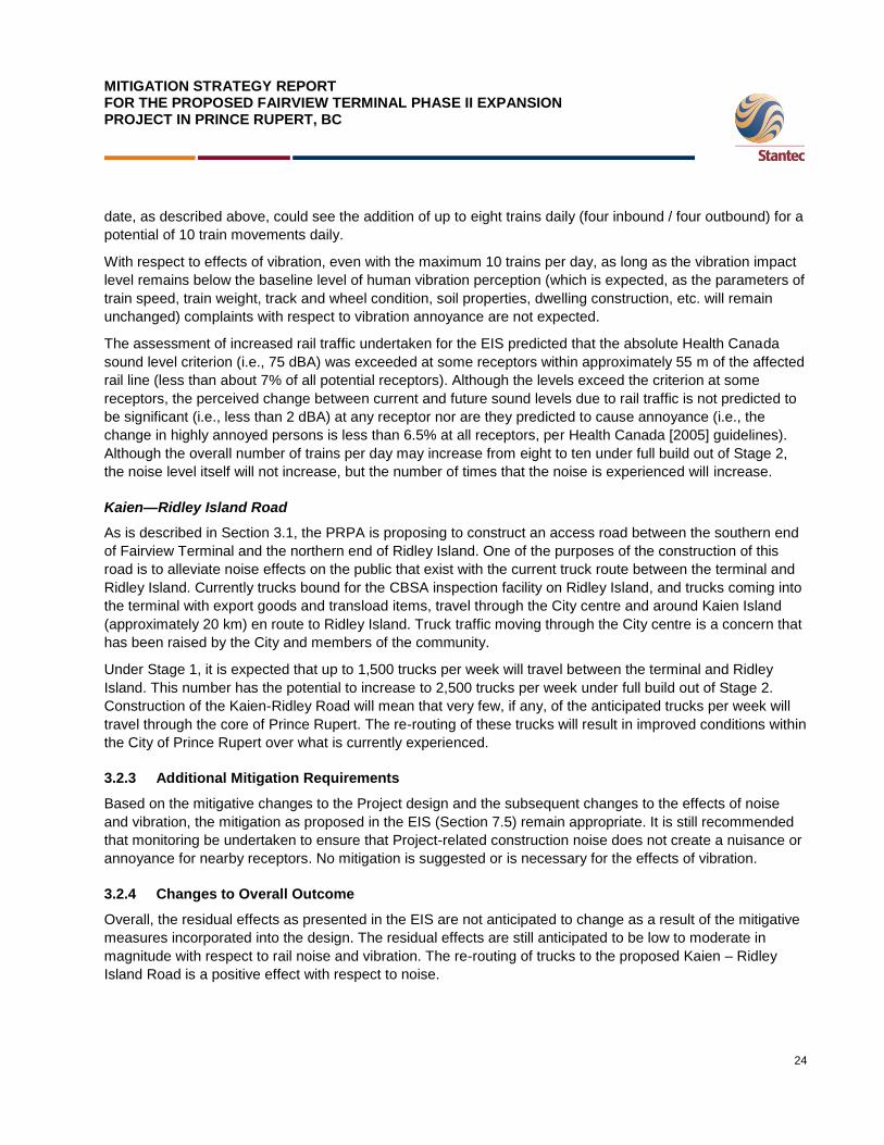
MITIGATION STRATEGY REPORT FOR THE PROPOSED FAIRVIEW TERMINAL PHASE II EXPANSION PROJECT IN PRINCE RUPERT, BC
24
date, as described above, could see the addition of up to eight trains daily (four inbound / four outbound) for a
potential of 10 train movements daily.
With respect to effects of vibration, even with the maximum 10 trains per day, as long as the vibration impact
level remains below the baseline level of human vibration perception (which is expected, as the parameters of
train speed, train weight, track and wheel condition, soil properties, dwelling construction, etc. will remain
unchanged) complaints with respect to vibration annoyance are not expected.
The assessment of increased rail traffic undertaken for the EIS predicted that the absolute Health Canada
sound level criterion (i.e., 75 dBA) was exceeded at some receptors within approximately 55 m of the affected
rail line (less than about 7% of all potential receptors). Although the levels exceed the criterion at some
receptors, the perceived change between current and future sound levels due to rail traffic is not predicted to
be significant (i.e., less than 2 dBA) at any receptor nor are they predicted to cause annoyance (i.e., the
change in highly annoyed persons is less than 6.5% at all receptors, per Health Canada [2005] guidelines).
Although the overall number of trains per day may increase from eight to ten under full build out of Stage 2,
the noise level itself will not increase, but the number of times that the noise is experienced will increase.
Kaien—Ridley Island Road
As is described in Section 3.1, the PRPA is proposing to construct an access road between the southern end
of Fairview Terminal and the northern end of Ridley Island. One of the purposes of the construction of this
road is to alleviate noise effects on the public that exist with the current truck route between the terminal and
Ridley Island. Currently trucks bound for the CBSA inspection facility on Ridley Island, and trucks coming into
the terminal with export goods and transload items, travel through the City centre and around Kaien Island
(approximately 20 km) en route to Ridley Island. Truck traffic moving through the City centre is a concern that
has been raised by the City and members of the community.
Under Stage 1, it is expected that up to 1,500 trucks per week will travel between the terminal and Ridley
Island. This number has the potential to increase to 2,500 trucks per week under full build out of Stage 2.
Construction of the Kaien-Ridley Road will mean that very few, if any, of the anticipated trucks per week will
travel through the core of Prince Rupert. The re-routing of these trucks will result in improved conditions within
the City of Prince Rupert over what is currently experienced.
3.2.3 Additional Mitigation Requirements
Based on the mitigative changes to the Project design and the subsequent changes to the effects of noise
and vibration, the mitigation as proposed in the EIS (Section 7.5) remain appropriate. It is still recommended
that monitoring be undertaken to ensure that Project-related construction noise does not create a nuisance or
annoyance for nearby receptors. No mitigation is suggested or is necessary for the effects of vibration.
3.2.4 Changes to Overall Outcome
Overall, the residual effects as presented in the EIS are not anticipated to change as a result of the mitigative
measures incorporated into the design. The residual effects are still anticipated to be low to moderate in
magnitude with respect to rail noise and vibration. The re-routing of trucks to the proposed Kaien – Ridley
Island Road is a positive effect with respect to noise.

MITIGATION STRATEGY REPORT FOR THE PROPOSED FAIRVIEW TERMINAL PHASE II EXPANSION PROJECT IN PRINCE RUPERT, BC
25
3.3 Vegetation
3.3.1 Introduction
The mitigative redesign reduces the overall effect of the Project on vegetation. The losses of ecological
communities of conservation concern and seepage swamp are reduced because the terminal footprint re-
design results in less upland clearing and the avoidance of Casey Creek. The loss of estuarine habitat
associated with the lagoon north of Porpoise Harbour is avoided with the relocation of the wye. However, the
relocation of the wye does result in a small increase in the loss of old forest.
3.3.2 Mitigative Redesign—Description of Changes to Effects on Vegetation
The Project re-design reduces the loss of ecological communities of conservation concern by 34.6%, from
2.6 ha to 1.7 ha, and only one ecological community of conservation concern is affected (Table 3-7) rather
than two affected by the 2009 Project design. The relocation of the wye increases the loss of the blue-listed
Western Hemlock– Sitka Spruce–Lanky Moss ecosystem unit, from 0.5 ha to 1.7 ha (Table 3-7). However,
the avoidance of Casey Creek means there is no longer any loss of the blue-listed Western Redcedar–Sitka
Spruce–Devil‘s Club ecosystem unit.
Table 3-7 Change in Loss of Ecological Communities of Conservation Concern with 2011 Redesign
Ecological Community of Conservation Concern Structural Stage 2009 EIS Area Lost (ha)
2011 Redesign Area Lost (ha)
Western Hemlock–Sitka Spruce–Lanky Moss
5 0.0 -0.5
6 0.0 0.0
7 -0.5 -1.2
Western Redcedar–Sitka Spruce–Skunk Cabbage 7 0.0 0.0
Western Redcedar–Sitka Spruce–Sword Fern 5 0.0 0.0
6 0.0 0.0
Western Redcedar–Sitka Spruce–Devil's Club
4 -1.2 0.0
5 -0.8 0.0
6 -0.1 0.0
7 0.0 0.0
Total -2.6 -1.7
The Project re-design reduces the loss of seepage swamp and estuarine habitat. The decrease in the area of
upland clearing, grubbing and stripping associated with the terminal reduces the loss of seepage swamp by
50%, from 0.6 to 0.3 ha (Table 3-8). The relocation of the wye from adjacent to the tidal marsh lagoon north of
Porpoise Harbour (i.e., Pond 6, Section 3.6) to near the CN bunkhouse, prevents any loss of the estuarine
habitat associated with that lagoon.
MITIGATION STRATEGY REPORT FOR THE PROPOSED FAIRVIEW TERMINAL PHASE II EXPANSION PROJECT IN PRINCE RUPERT, BC
26
Table 3-8 Change in Loss of Seepage Swamp with 2011 Redesign
Wetland Ecosystem Unit Canadian Wetland Classification System Category
2009 EIS Area Lost (ha)
2011 Redesign Area Lost (ha)
Shore Pine–Yellow Cedar–Sphagnum Seepage swamp 0.0 0.0
Western Redcedar–Sitka Spruce–Skunk Cabbage
Seepage swamp 0.0 0.0
Western Redcedar–Yellow Cedar–Goldthread
Seepage swamp -0.6 -0.3
Total -0.6 -0.3
Two shoreline vegetation communities (beach and Lyngby‘s Sedge–Seaside Plantain ecosystem unit) were
mapped and addressed as part of the terrestrial vegetation assessment in the 2009 EIS. However, following
IRs, these communities are now designated as ―marine habitat‖. Changes to marine habitat resulting from the
Project redesign are discussed under Marine Environment (Section 3.7).
The discussion of the changes to freshwater aquatic and riparian habitat resulting from the Project re-design
is presented in detail under Freshwater Environment (Section 3.6).
The Project re-design results in a small (8%) increase in the loss of old forest, from 1.2 to 1.3 ha (Table 3-9).
This is due to the relocation of the wye. The majority of the old forest loss is associated with an ecological
community of conservation concern (Western Hemlock–Sitka Spruce–Lanky Moss ecosystem unit) as
discussed above.
Table 3-9 Change in Loss of Old Forest with 2011 Redesign
Old Forest Ecosystem Unit 2009 EIS Area Lost (ha) 2011 Redesign Area Lost (ha)
Western Redcedar–Western Hemlock–Salal -0.7 -0.1
Western Redcedar–Sitka Spruce–Skunk Cabbage 0.0 0.0
Western Redcedar–Yellow Cedar–Goldthread 0.0 0.0
Western Redcedar–Yellow Cedar–Salal 0.0 0.0
Western hemlock–Sitka Spruce–Lanky Moss -0.5 -1.2
Western Redcedar–Sitka Spruce–Devil's Club 0.0 0.0
Total -1.2 -1.3
3.3.3 Additional Mitigation Requirements
The mitigation measures proposed in the EIS (Section 9) (and subsequent IRs) remain valid and adequate.
This includes conducting a pre-development assessment of the wye location, as was proposed for the original
wye location in the EIS. Given the new location of the wye, this pre-development assessment will now be
focused on minimizing clearing of forest in this area in order to reduce the loss of old forest and an ecological
community of conservation concern (Western Hemlock–Sitka Spruce–Lanky Moss ecosystem unit). The pre-
development assessment of this area will also include a rare plant survey.

MITIGATION STRATEGY REPORT FOR THE PROPOSED FAIRVIEW TERMINAL PHASE II EXPANSION PROJECT IN PRINCE RUPERT, BC
27
3.3.4 Changes to Overall Outcome
No change in the characterization of the residual effects on vegetation presented in the 2009 EIS is
anticipated as a result of the mitigative redesign. The changes to the residual effects are small and primarily
positive for vegetation. In particular, the reduction in loss of seepage swamp and the avoidance of the
estuarine habitat adjacent to the lagoon are substantive positive outcomes of the Project re-design.
3.4 Wildlife and Wildlife Habitat
3.4.1 Introduction
The changes to the Project design will result in an overall decrease in potential effects on Wildlife and Wildlife
Habitat. Avifauna is considered separately in Section 3.5. The footprint of the terrestrial portion of the Project
(all components) has been reduced by 42%, resulting in less habitat loss for terrestrial mammals and
herptiles. The 2009 EIS (Section 10) considered the potential effects of habitat loss or alteration, sensory
disturbance, and risk of mortality on wildlife. The magnitude of the effect of habitat loss or alteration will
decrease as a result of the mitigative re-design; however there may be a slight increase in the potential
effects of sensory disturbance or of risk of mortality to wildlife from collisions with vehicles or rail traffic
associated with the updated traffic volumes.
3.4.2 Mitigative Redesign—Description of Changes to Effects on Wildlife
3.4.2.1 Habitat Loss and Alteration
For wildlife the mitigative re-design results in an overall decrease in the magnitude of habitat loss and
alteration compared to the 2009 EIS submission. The terrestrial footprint of the terminal portion of the Project
was 33 ha in the 2009 EIS. With the 2011 re-design, the terrestrial footprint has been reduced to 15.7 ha,
leaving 17.3 ha of forested land untouched. There is no change to habitat loss from the CN sidings
component; there will continue to be a loss of approximately 12.85 ha, as presented in the 2009 EIS
submission. The proposed road alignment between the terminal and Ridley Island will result in additional loss
of 1.5 ha of terrestrial habitat compared to the 2009 EIS. In addition to the overall reduction in loss of habitat,
the wye footprint of the CN rail line has been reduced in size and relocated east of its original location (Figure
2-2). As a result of the mitigative re-design the area affected by the wye will be reduced in size by 2.11 ha,
from 3.36 ha (in the 2009 EIS) to 1.2 ha.
The mitigative re-design will result in 17.3 ha decrease in terrestrial habitat loss for wildlife compared to the
2009 EIS submission (Table 3-10).
Table 3-10 Difference in Terrestrial Habitat Loss between the 2009 EIS Submission and the 2011 Mitigative Redesign for each Project Component
Project Component 2009 EIS Submission
Footprint Size (ha)
2011 Mitigative Redesign
Footprint Size (ha)
Change in Footprint size (ha; 2009 - 2011)
Terrestrial Terminal Footprint 33 15.7 -17.3
CN Siding 12.85 12.85 0
Kaien—Ridley Island Road Alignment
n/a 1.5 1.5
CN Wye 3.36 1.25 2.11
Total 49.21 31.3 17.91

MITIGATION STRATEGY REPORT FOR THE PROPOSED FAIRVIEW TERMINAL PHASE II EXPANSION PROJECT IN PRINCE RUPERT, BC
28
3.4.2.2 Direct Mortality
Increased rail traffic on the CN Skeena subdivision could result in increased moose mortality. Rail traffic along the subdivision is expected to increase from 9.3 (baseline, including existing trains in and out of Fairview) to 17.3 trains per day. The 2009 EIS presented a maximum of 15.3 trains per day. With the projected increase in rail traffic, there may be an increase in the frequency of moose collisions to 0.056 collisions/km/year, increasing mortality from 6.75 (existing) to 12.6 moose per year. The current rate of collisions is 0.03 collisions/km/year. The Project effects from mortality are predicted to remain not significant.
3.4.3 Additional Mitigation Requirements
Based on the mitigative re-design, and the subsequent changes to wildlife habitat effects and potential
changes with respect to moose mortality (as described in Section 3.4.2.), the mitigation and/or monitoring as
proposed in the 2009 EIS (Section 10.6 and 10.8, and subsequent IRs) remain valid and adequate.
3.4.4 Changes to Overall Outcome
The changes to the Project design will result in an overall decrease in the residual effects on wildlife and
wildlife habitat. The size of the terrestrial portion of the terminal has been reduced by 52% (33 to 15.7 ha),
resulting in less habitat loss for wildlife. Additionally, the CN wye has been relocated to avoid loss and
alteration of wetland habitat at the tidal marsh lagoon and to avoid potential effects on habitat function for
wetland and riparian species (as discussed in Sections 3.5 and 3.3). The addition of the road between the
terminal and Ridley Island slightly increases the level of sensory disturbance experienced by wildlife in
adjacent habitats. The additional rail traffic will result in an increase in the frequency moose collisions.
3.5 Avifauna
3.5.1 Introduction
The changes to the Project design will result in an overall decrease in potential effects on Avifauna. The size
of the terrestrial portion of the Project (all components) has been reduced by 42%, resulting in less habitat
loss for land birds. The CN wye has been relocated from the tidal marsh lagoon to avoid loss and alteration of
wetland habitat and to avoid potential effects on habitat function for wetland and riparian bird species.
The 2009 EIS submission (Section 11) considered the potential effects of habitat loss or alteration, sensory
disturbance, and risk of mortality on avifauna. Since the Project effects on avifauna differed for marine and
terrestrial components, effects were considered for two key indicators (KIs): i) marine birds; and ii) land birds.
The effect of habitat loss or alteration for both marine birds and land birds will change as a result of the
mitigative redesign; there will be an increase in sensory disturbance for marine birds; and the risk of mortality
for land birds will decrease.
3.5.2 Mitigative Redesign—Description of Changes to Effects on Avifauna
3.5.2.1 Habitat Loss and Alteration
Land birds
For land birds the mitigative re-design results in an overall decrease of habitat loss and alteration compared
to the 2009 EIS submission. The terrestrial footprint of the terminal was 33 ha in the 2009 EIS submission.
With the re-design, the terrestrial footprint has been reduced to 15.7 ha, leaving 17.3 ha of forested land
untouched. There is no change to habitat loss from the CN sidings portion; there will still be a loss of

MITIGATION STRATEGY REPORT FOR THE PROPOSED FAIRVIEW TERMINAL PHASE II EXPANSION PROJECT IN PRINCE RUPERT, BC
29
approximately 12.85 ha, as presented in the 2009 EIS submission. The Kaien-Ridley Island Road alignment
will result in additional loss of 1.5 ha of terrestrial habitat compared to the 2009 EIS.
In addition to the overall reduction in loss of habitat, the wye portion of the CN rail line has been reduced in
size and relocated east of its original location (Figure 2-2) to avoid potential impacts on wetlands and wetland
function for bird species. As a result of the mitigative re-design, the wye turnaround will result in a loss of
forested habitat instead of wetland and riparian habitat (refer to Section 3.3 above). Wetlands provide
breeding and feeding habitat function for marsh birds, waterfowl, shorebirds, and songbirds. The relocation of
the wye will avoid the loss of 3,374 m2 (0.3374 ha) area of a tidal marsh lagoon and will reduce potential
effects on birds using the wetland habitat. As a result of the mitigative re-design the wye will be reduced in
size by 2.11 ha from 3.36 ha (in the 2009 EIS) to 1.2 ha.
The 2011 mitigative re-design will result in 11.61 ha decrease in terrestrial habitat loss for land birds
compared to the 2009 EIS submission (see Table 3-4 in Section 3.4.2).
Marine Birds
For marine birds, habitat loss will increase slightly given the increased area of the marine terminal at full build
out. The total loss or alteration of marine bird habitat considered in the 2009 EIS was approximately 7.45 ha.
With the Project re-design there will be a total loss of 11.1 ha of marine bird habitat due to infilling (3.3 ha for
the northern expansion; 7.8 ha for the southern expansion). The CN sidings and the road between the
terminal and Ridley Island will result in additional loss of 7.7 ha of potential marine bird habitat along the
shoreline compared to what was presented in the 2009 EIS submission (Figure 2-2).
Sensory Disturbance
The Project redesign will shift anticipated truck traffic from moving through the City centre to moving adjacent
to the shoreline. This re-direction of truck traffic will increase sensory disturbance to marine birds foraging
there. However, this shoreline is currently subject to rail and vessel traffic and birds are likely to habituate to
the increased disturbance caused by the increase in road and rail traffic.
Direct Mortality
The mitigative redesign will not result in any changes to the risk of mortality for marine birds and will reduce
the risk of mortality for land birds. There is potential risk of mortality to individual birds, their nests, eggs, or
young if vegetation clearing activities occur during the bird nesting season (May 1 to July 31). The 52%
reduction in the size of the terrestrial portion of the terminal footprint reduces this risk of mortality.
3.5.3 Additional Mitigation Requirements
Based on the mitigative changes to the Project design and the subsequent changes to the effects on
avifauna, the mitigation as proposed in the EIS (and subsequent IRs) are adequate.
At a technical meeting held on May 25, 2010 the Canadian Wildlife Service (CWS) requested additional bird
survey data to provide a higher level of certainty on bird use of the Project area to determine bird species and
abundance potentially affected by expansion of the terminal and rail infrastructure. Specifically, CWS
requested:
1. Monthly marine-bird surveys over a 12 month period including: (a) surveys from vessels starting at
the Fairview Terminal, and extending around Ridley Island and into Porpoise Harbour near Zanardi
Rapids; and (b) surveys from shore at 500 to 700 m intervals following the rail line between Fairview

MITIGATION STRATEGY REPORT FOR THE PROPOSED FAIRVIEW TERMINAL PHASE II EXPANSION PROJECT IN PRINCE RUPERT, BC
30
Terminal and Zanardi Rapids (following Resource Inventory Standards Committee [RISC] methods
for seabirds, 1997).
2. Two spring surveys to determine marsh habitat use by birds in June 2010 in the three marshes at the
south end of the two sidings (following RISC inventory methods for marsh birds: bitterns and rails,
1998).
3. Two breeding-bird surveys, in early and late June, for land birds along the proposed CN rail line
expansion (following RISC inventory methods for forest and grassland songbirds, 1999).
4. Three raptor surveys (following RISC inventory methods for raptors, 2001).
Marine bird surveys around the terminal and along the CN rail line to date include vessel surveys and
stationary shore count surveys on:
Fall 2006 (September 29 to October 1)
Spring 2007 (April 30 to May 2)
June 2010 (June 11 to 14 and June 22 to 24)
June 2011
July 2011
August 2011
The survey results are consistent with the regional data collected from a variety of sources (summarized in a
letter submitted to Environment Canada on June 18, 2010). Overall 71 marine bird species (including water
birds, seabirds, and shorebirds) have been recorded among these regional and local data sets. Of those two
species (marbled murrelet [threatened], and ancient murrelet [endangered]) are listed under the Species at
Risk Act. Sixteen marbled murrelet have been recorded on Project surveys to date; 11 in spring 2007 and 5 in
June 2010. No ancient murrelets have been recorded. Marine bird species use the waters around the Project
area for feeding. The small increase in loss of shoreline and marine habitat, as described above, will result in
a small reduction of availability of prey species for marine birds. However, relative to the overall availability of
these habitats within the RSA this is not likely to affect populations of marine birds.
The marsh bird surveys, breeding bird surveys, and raptor surveys are complete. The results of these surveys
will be submitted under separate cover.
3.5.4 Changes to Overall Outcome
The changes to the Project design will result in an overall decrease in the residual effects on Avifauna. The
size of the terrestrial portion of the terminal has been reduced, resulting in less habitat loss for land birds, and
the CN wye has been relocated to avoid loss and alteration of wetland habitat and to avoid potential effects
on habitat function for wetland and riparian bird species. There will be a slight increase in habitat loss for
marine birds and a slight increase in the level of sensory disturbance experienced by marine birds foraging at
the shoreline, as a result of truck traffic along the proposed Kaien-Ridley Island Road.
3.6 Freshwater Environment
The mitigative re-design will result in an overall decrease in potential effects on the Freshwater Environment,
compared to the 2009 EIS submission. The revised terminal layout will avoid the destruction of Casey Creek
and its supporting tributaries, and reduce the magnitude of impacts on another fish-bearing watercourse

MITIGATION STRATEGY REPORT FOR THE PROPOSED FAIRVIEW TERMINAL PHASE II EXPANSION PROJECT IN PRINCE RUPERT, BC
31
adjacent to the terminal site. The relocation of the railroad wye from a tidal marsh lagoon to a primarily dry
site will also eliminate additional losses of freshwater habitat. The EIS (2009; Section 12.2.1) considered
three major potential effects on freshwater fish and fish habitat as a result of the Project including: the
introduction of deleterious substances to the freshwater environment; changes in freshwater habitat quantity
and quality; and changes in fish mortality. The magnitude of all three of these potential effects will be
decreased as a result of the mitigative redesign.
3.6.1 Mitigative Redesign—Description of Changes to Effects on Freshwater
The mitigative re-design of the Project will result in an overall decrease in potential effects on Freshwater
Environment, compared to the 2009 EIS submission. The total destruction of freshwater habitat estimated in
the 2009 EIS included approximately 0.72 ha (7,209 m2) of fish-bearing freshwater aquatic habitat and 4.46
ha (44,630 m2) of riparian habitat. The Project re-design will result in a total destruction of 0.23 ha (2,306 m
2)
of fish-bearing aquatic habitat and 1.55 ha (15,527 m2) of riparian habitat—a 68 and 65.2% reduction,
respectively (see Table 3.11).
According to the 2009 EIS submission, the proposed terminal expansion would have destroyed downstream
portions of two fish-bearing watercourses, referred to as Watercourse 2 (W2) and Casey Creek (W4, 5).
Fisheries surveys conducted demonstrated that watercourse W2 contains only Sculpin (general), whereas
Casey Creek contains Sculpin species as well as Dolly Varden, a species of conservation concern in British
Columbia.
The revised terminal for the Project re-design greatly reduces the amount of harmful alteration, disruption or
destruction (HADD) required along W2 and Casey Creek. As with the original Project plan, water from the
upper reaches of W2 will be conveyed around the terminal via a series of existing and expanded drainage
structures. Although the revised terminal footprint no longer overlaps Casey Creek, the CN rail line must
connect with the terminal site, as will the proposed road between the terminal and Ridley Island; thus the
impacts are not completely eliminated, but are dramatically reduced (see Table 3-11; Figure 3-1).
Table 3-11 Freshwater Fish-bearing HADD
Area Watercourse/Waterbody Aquatic Habitat Destruction Riparian Habitat Destruction
2009 EIS 2011 Redesign 2009 EIS 2011 Redesign
Terminal
Watercourse 2 539 m2 649 m
2 23,460 m
2 13,253 m
2
Watercourse 4, 5 (Casey Creek)
1,984 m2 0 m
2 18,070 m
2 721 m
2
CN Sidings and Wye
Watercourse 22 54 m2 254 m
2 – 1,553 m
2
Watercourse 25 35 m2 0 m
2 – –
Watercourse 26 42 m2 0 m
2 – –
CV 30, 31 54 m2 0 m
2 – –
Pond 4 1,127 m2 1,403 m
2 – –
Pond 6 3,374 m2 0 m
2 3,100 m
2 0 m
2
Total 7,209 m2 2,306 m
2 (-68%) 44,630 m
2 15,527 m
2 (-65.2%)
In addition to those watercourses affected by the terminal footprint, the 2009 EIS described effects at three
other fish-bearing watercourses (W22, W25, and W26), two fish-bearing ponds (Ponds 4 and 6), and a culvert
location east of Pond 6 (CV 30 and 31). Fisheries surveys demonstrated that watercourse W22 contains

MITIGATION STRATEGY REPORT FOR THE PROPOSED FAIRVIEW TERMINAL PHASE II EXPANSION PROJECT IN PRINCE RUPERT, BC
32
Coho salmon; Pond 4, defined as a tidal basin marsh contains Sculpin and Threespine stickleback; W25
contains Sculpin and Coastal cutthroat trout, a species of conservation concern in British Columbia; and both
W26 and Pond 6 (a tidal marsh lagoon) contain Sculpin.
The relocation of the wye in the Project redesign will eliminate any potential impacts at W25, W26, CV 30 and
31, and Pond 6; however, some potential impacts are still expected at W22 and Pond 4. Some additional
impact areas have also been identified at W22, near its confluence with Pond 4, due to impingement by a
small portion of the new Wye footprint (see Table 3-11; Figure 3-1).

DATE11/08/2011
DRAWN BY
FIGURE NO. 3-1
FRESHWATER IMPACTS NAD 83
W2Aquatic HADD = 0.0649haRiparian HADD = 1.3253ha
Casey Creek (W4,5)Aquatic HADD = 0haRiparian HADD = 0.072056ha
411000.000000
411000.000000
411500.000000
411500.000000
412000.000000
412000.000000
412500.000000
412500.000000
6014
500.00
0000
6014
500.00
0000
6015
000.00
0000
6015
000.00
0000
6015
500.00
0000
6015
500.00
0000
6016
000.00
0000
6016
000.00
0000
6016
500.00
0000
6016
500.00
0000
6017
000.00
0000
6017
000.00
0000
PROJECTION
DATUM
UTM - Zone 9 R Stohmann
CHECKED BY
±
V:\A
ctive
\1231
1000
3\gis\
figur
es\F
airvie
w_Fig
_00_
Fairv
iew_2
011_
HADD
.mxd
Watercourse - FishbearingProject Footprint (2011)Project Footprint (2009)Aquatic ImpactRiparian Impact
W22Aquatic HADD = 0.0254haRiparian HADD = 0.1553ha
Pond 4 NorthAquatic HADD = 0.14031ha
413500.000000
413500.000000
414000.000000
414000.000000
6011
000.00
0000
6011
000.00
0000
Wye Junction
Terminal
±
!(
KEY PLAN1:200,000
EXISTING FAIRVIEW TERMINALDIGBY
ISLAND
PORTEDWARDRIDLEY
ISLAND
KAIENISLAND
TSIMPSEAN PENINSULA
±PRINCERUPERT
0 100 200 300 400 500Metres
1:12,000
BARRETTROCK
G Velema

MITIGATION STRATEGY REPORT FOR THE PROPOSED FAIRVIEW TERMINAL PHASE II EXPANSION PROJECT IN PRINCE RUPERT, BC
34
3.6.2 Additional Mitigation Requirements
Based on the mitigative changes to the Project design and the subsequent changes to the freshwater
environment, the mitigation and/or monitoring as proposed in the 2009 EIS (Section 12.5.1.2 and subsequent
IRs) are adequate. With respect to the introduction of deleterious substances, the EIS presented a series of
best management practices (BMPs) as mitigation; these remain adequate and appropriate. With respect to
habitat quality and quantity, revised habitat compensation options will be discussed with DFO, to reflect the
reduced areas of loss and/or alteration. The overall goal of achieving a ‗net gain‘ of the productive capacity of
fish habitats will be met through habitat compensation. With respect to fish mortality, the EIS presented BMPs
aimed at reducing or eliminating effects of the Project on fish mortality risk. These mitigation measures remain
adequate.
3.6.3 Changes to Overall Outcome
The mitigative re-design will result in an overall decrease in the residual effect on the freshwater environment.
The terrestrial footprint of the proposed terminal expansion has been reduced, and the CN wye has been
relocated, resulting in a marked reduction in not only the number of impacted fish-bearing watercourses, but
also the magnitude of any potential impacts at the remaining affected fish-bearing watercourses. Habitat
compensation for loss of freshwater habitat will be required; however, the total area requiring compensation is
reduced by nearly 66% from the 2009 EIS submission.
3.7 Marine Environment
3.7.1 Introduction
The Project re-design results in an overall increase in the geographical extent of marine habitat affected by
the Project. Increased vessel traffic (ULCSs during operation) is anticipated. The reduced volume of material
being disposed of at sea will reduce the duration and magnitude of potential effects on marine animals and
results in more flexibility to work within standard DFO work windows to reduce potential effects on migrating
juvenile salmon and other marine species.
3.7.2 Mitigative Redesign—Description of Changes to Effects on the Marine Environment
The addition of the northern expansion area and the road between the terminal and Ridley Island in the
Project .re-design will result in a net increase in marine habitat loss, disturbance and alteration compared with
that proposed in the 2009 EIS submission. A field survey of the northern expansion area was undertaken in
June 2011. Results of this survey will be submitted under separate cover.
A total of 32.6 ha of marine habitat will be lost, disturbed or altered, as opposed to the 18.46 ha of loss that
was previously expected. The expected loss of eelgrass remains unchanged (approximately 0.12 ha) (Figure
3-2). There could be a slight increase in the loss of other habitat forming marine vegetation (e.g., bull kelp)
and very minimal increase in the loss of marine riparian vegetation on the shoreward side of the CN rail line at
the southern end of Kaien Island. Subtidal and intertidal marine habitats make up the largest portion of marine
habitat loss in the Project footprint. This will result in higher mortality of benthic species and will require
revision of the habitat compensation plan to reflect the revised Project footprint (see Section 3.7.2). The
increased marine footprint will not have substantial implications for other key marine components. As
discussed in the 2009 EIS submission (Section 13), benthic habitat similar to that which is expected to be lost
due to the Project is abundant in the region and limited mortality of benthic species in the Project footprint is
not expected to have significant residual or cumulative effects on benthic species or benthic habitat in the
region. Although the geographic extent of marine habitat loss is expected to be higher with the Project

MITIGATION STRATEGY REPORT FOR THE PROPOSED FAIRVIEW TERMINAL PHASE II EXPANSION PROJECT IN PRINCE RUPERT, BC
35
redesign the overall residual effect for the Marine Environment is expected to remain not significant,
particularly in consideration of habitat compensation measures to be undertaken to comply with the objective
of no net loss of fish habitat.

DATE11/08/2011
DRAWN BY
FIGURE NO. 3-2
MARINE HABITATNAD 83
411000.000000
411000.000000
411500.000000
411500.000000
412000.000000
412000.000000
412500.000000
412500.000000
6014
500.00
0000
6014
500.00
0000
6015
000.00
0000
6015
000.00
0000
6015
500.00
0000
6015
500.00
0000
6016
000.00
0000
6016
000.00
0000
6016
500.00
0000
6016
500.00
0000
6017
000.00
0000
6017
000.00
0000
PROJECTION
DATUM
UTM - Zone 9 R Stohmann
CHECKED BY
±
V:\A
ctive
\1231
1000
3\gis\
figur
es\F
airvie
w_Fig
_03_
02_F
airvie
w_20
11_F
ootpr
int_M
arine
.mxd
Project Footprint (2011)Marine Habitat within the Project FootprintEelgrass
CN Siding ComponentUnchanged
412000.000000
412000.000000
412500.000000
412500.000000
413000.000000
413000.000000
413500.000000
413500.000000
414000.000000
414000.000000
414500.000000
414500.000000
6010
500.00
0000
6010
500.00
0000
6011
000.00
0000
6011
000.00
0000
6011
500.00
0000
6011
500.00
0000Wye Junction
Terminal
±
!(
KEY PLAN1:200,000
EXISTING FAIRVIEW TERMINALDIGBY
ISLAND
PORTEDWARDRIDLEY
ISLAND
KAIENISLAND
TSIMPSEAN PENINSULA
±PRINCERUPERT
0 100 200 300 400 500Metres
1:12,000
BARRETTROCK
K Hewgill

MITIGATION STRATEGY REPORT FOR THE PROPOSED FAIRVIEW TERMINAL PHASE II EXPANSION PROJECT IN PRINCE RUPERT, BC
37
A slightly reduced area of marine dredging and a greatly reduced volume of material requiring disposal at sea
(see Section 3.8 below) with the mitigative re-design will result in a substantial overall decrease of effects
related to sedimentation and marine noise on marine organisms. This change results in an overall decrease in
expected residual and cumulative effects on all components of the marine environment compared with the
2009 EIS with respect to dredging and ocean disposal.
Vessel traffic is predicted to be higher than previously anticipated in the 2009 EIS; the original estimate of
eight vessels per week has been revised, due to greater terminal efficiencies, to include an expected 10–14
vessels per week during full build out. This will result in increased frequency of the effect of underwater noise
on marine animals; but effects are predicted to remain not significant for all marine species where underwater
sensory disturbance may apply (Pacific salmon, humpback whale, and harbour porpoise).
3.7.3 Additional Mitigation Requirements
The increased loss of marine benthic habitat will require a revision to the draft habitat compensation plan.
Prior to implementation of the habitat compensation plan, habitat forming marine vegetation (e.g., eelgrass
and kelp) will be surveyed and quantified to reflect more accurate estimates of fish habitat loss.
3.7.4 Changes to Overall Outcome
The re-design of the proposal marine terminal and road corridor are anticipated to have a minimal overall
change on the residual effects to the Marine Environment. The greatest increase in loss will be to benthic
habitat within the marine footprint. This habitat is not unique in the region and regional benthic populations will
not be significantly affected by the re-designed Project. All Project design changes and associated
quantification of marine habitat will be incorporated into the habitat compensation plan to mitigate for the loss
and/or disturbance of fish habitat in the Project footprint.
3.8 Disposal at Sea
3.8.1 Introduction
The Project re-design results in an 87% reduction in the volume of material proposed for disposal at sea.
There will be no disposal at sea associated with construction of Stage 1 of the Project. A disposal at sea
permit is expected to be required for Stage 2 of the Project, closer to 2018.
With respect to the disposal of material at sea for the purpose of constructing Stage 2, the PRPA is proposing
to use Brown Passage for the disposal of 180,000 m3 of dredged marine sediments. Brown Passage is
approximately 30 km west of Prince Rupert, in Chatham Sound. The site is one nautical mile in diameter,
approximately 200 m deep, and has been used on seven occasions since 1972, most recently in 2006/2007
during construction of Fairview Terminal Phase I.
3.8.2 Mitigative Redesign—Description of Changes to Effects on the Marine Environment
During the IR process, the disposal at sea of 1,335,000 m3 of material, consisting of 180,000 m
3 of subtidal
marine sediments and 1,155,000 m3 of terrestrial overburden was assessed (Stantec 2010). One of the
primary focuses of the Project re-design has been to reduce the potential effects associated with disposal at
sea. With the re-designed terminal layout, there is an 87% reduction in the volume of material proposed for
disposal at sea. Much of the terrestrial overburden material will not be excavated due the reduced terrestrial
footprint (Section 3.3); any excavated terrestrial overburden will be re-used on site. The only material that will

MITIGATION STRATEGY REPORT FOR THE PROPOSED FAIRVIEW TERMINAL PHASE II EXPANSION PROJECT IN PRINCE RUPERT, BC
38
be disposed of at sea is the 180,000 m3 of dredged subtidal marine sediment from south of the existing
terminal during construction of Stage 2 (Figure 3-3).
The reduction in the volume of material being disposed of at sea (during Stage 2) will result in substantially
fewer vessel trips between the dredge site and the disposal site, over a much shorter period of time. Under
the 2009 Project plan, dredging and disposal of material at sea was expected to take 128 days. With the
Project re-design, the number of days anticipated to complete the disposal is approximately 25. This is an
80% reduction in the number of days where vessels have the potential to affect or interact with marine
resources. The reduced number of days required to complete the disposal also results in much greater
flexibility for the contractors to work within the DFO work windows.
Following the 2009 EIS submission, during the IR process, modeling of the fate of the disposed material was
undertaken (ASL 2010). This modeling was used to support the assessment of potential effects of the
disposal on: sediment, water quality, marine biota and human uses (First Nations, commercial and
recreational fishing). The sediment fate modeling is currently being updated based on lower disposal volumes
and some changes to modeling assumptions to account for changes in disposal material (i.e., no terrestrial
overburden) and discussions with Environment Canada. Initial results indicate that there will be a 73%
reduction in the maximum deposition depth (from 173mm originally anticipated to 106 mm now anticipated) 21
days after completion of disposal. Full results of the modeling will be available in late August / early
September 2011, and will be provided at that time. The update addresses Environment Canada concerns that
the initial model approach might underestimate adverse effects and provides a sensitivity analysis of the
influence of finer material on TSS levels during disposal.


MITIGATION STRATEGY REPORT FOR THE PROPOSED FAIRVIEW TERMINAL PHASE II EXPANSION PROJECT IN PRINCE RUPERT, BC
40
3.8.3 Additional Mitigation Requirements
The Project re-design greatly reduces the amount of ocean disposal requirements for the Project and no
additional mitigation is recommended. A detailed sediment sampling program in support of a disposal at sea
permit will be undertaken when terminal capacity and volumes indicate that construction of Stage 2 is
warranted. Mitigation measures relating to disposal at sea will be discussed and developed in consultation
with Environment Canada‘s Environmental Assessment and Marine Programs group during the permitting
process.
3.8.4 Changes to Overall Outcome
Effects on sediment and quality, water quality, biota and human use will be reduced as a result of the Project
re-design and revised requirements for ocean disposal of material. Any effects are anticipated to be low in
magnitude, and will be primarily concentrated within the bounds of the disposal site. Measureable effects are
not expected for areas outside of the site boundaries. Effects resulting from tug and barge movement
between the dredge area and the disposal site will be substantially reduced. Total disposal volume will be
reduced by 87%. The number of days of potential effects from tug and barge movement will be reduced by
80%.
Additional information will be provided upon completion of the fate of sediment modeling in late August or
early September 2011.
The dredging and disposal at sea of dredged subtidal material is expected to be undertaken as part of the
Stage 2 work. It is unlikely that this work will take place prior to 2018 at the earliest. A detailed sediment
sampling program in support of a disposal at sea permit will be undertaken when it is clear that Stage 2 will
proceed. In accordance with Environment Canada policy, sampling data becomes invalid after four years;
therefore sediment sampling must be deferred until it is closer in time to any confirmed requirements for
ocean disposal.
Although modeling is not yet complete, based on the substantial reduction in the volume of material being
disposed, it is expected that the magnitude and geographic extent of the effects of disposal at sea on marine
resources will be lowered substantially. Disposal-related changes are expected to be not significant, will occur
largely within the area designated for disposal at sea, and are not predicted to result in increased contaminant
levels, or interfere with fish habitat (other than short term burial of benthic invertebrates) or fisheries.
3.9 Socio-Economic Conditions
The socio-economic assessment in the 2009 EIS submission focused on the predicted change in land use
related changes to socio-economic conditions. The Project as originally described, will result in a change in
existing and future land uses. The change included loss of access for informal recreational use and
development of lands for intended purposes under existing land use planning documents (Section 14.2.1 of
the EIS). Project re-design is not expected to result in a change to the residual effects for socio-economic
conditions as presented in Section 14.7 of the EIS (i.e., not significant). There will be a reduced effect on
informal recreational use, given the reduced activity in and around Fort Casey. The development of lands for
their intended use is still expected to result in an important positive effect that will be realized beyond the City
of Prince Rupert and the Skeena-Queen Charlotte Regional District. The mitigation proposed in the 2009 EIS
submission remains valid and applicable.
Effects on traditional land use by First Nations are addressed in Section 3.12.

MITIGATION STRATEGY REPORT FOR THE PROPOSED FAIRVIEW TERMINAL PHASE II EXPANSION PROJECT IN PRINCE RUPERT, BC
41
3.10 Archaeology and Heritage Resources
3.10.1 Introduction
The Project site, as described in Section 16 of the 2009 EIS submission, lies within the claimed traditional
territories of several First Nations, and is associated with the northern sub-area of the North West Coast
culture, characterized by archaeological shell middens, burial sites, culturally modified trees, and seasonal
village sites. The EIS included assessment of both archaeological and heritage resources.
The revised Project footprint will result in fewer archaeological and heritage sites being affected.
3.10.2 Mitigative Redesign—Description of Changes to Effects on Archaeology and Heritage Resources
Four sites in particular will be fully or partially avoided under the mitigative re-design. These sites are as
follows:
GbTo-13 is found south of the Casey Creek drainage culverts. The inland side has about 60 m3
of intact midden and the shoreline side may have a little over 200 m3. There is a total of about
50 m3 of disturbed midden at the site. Intertidal lithics and canoe runs are considered 100%
intact. There is the potential for human burials to be found at this site.
GbTo-107 is in the bank of Casey Creek and consists totally of re-deposited shell midden, which
was largely removed during the Archaeological Impact Assessment testing.
GbTo-100 is located approximately 200 m south of Casey Creek. This site contains the remains
of Fort Casey, which consisted of a battery mounting, a number of naval port defence guns, and
an observation tower for fire control and operation of a submarine net.
GbTn-67 is a site near Mile 88 (location of original wye), consisting of five culturally modified
trees; one chipped and chiselled tree with three recorded features, one chiselled with two
recorded features, one taper bark-stripped tree, and two rectangular bark-stripped trees. Some of
the features are stone tool marks, which suggest an age predating AD1846.
It is expected that with the mitigative re-design, between seven and 12 archaeological and heritage resources
will be lost as a result of the Project, rather than a maximum of 16, as presented in the 2009 EIS submission.
3.10.3 Additional Mitigation Requirements
As described in the EIS (Section 16.5.2), mitigation measures with respect to archaeological and heritage
resources will be determined through an Archaeological Side Table. The EIS provides a list of proposed,
preliminary mitigation measures; these mitigation measures are still applicable.
3.10.4 Changes to Overall Outcome
Under the original Project design, sites GbTo-13, GbTo-107 and GbTo-100 would have been completely
removed. Site GbTn-67 was going to be potentially impacted. The mitigative design changes will likely save
all four sites, although there is the potential for some disturbance to GbTo-13 from construction of the
proposed road and sidings between the terminal and Ridley Island. Although PRPA is proposing to construct
a road between the terminal and Ridley Island, this road will not affect any archaeological or heritage sites
that were not already assessed as being affected in the EIS.
The residual effect on archaeological and heritage resources remains predicted to be not significant..

MITIGATION STRATEGY REPORT FOR THE PROPOSED FAIRVIEW TERMINAL PHASE II EXPANSION PROJECT IN PRINCE RUPERT, BC
42
3.11 First Nations Current Traditional Use
The potential effects of the Project re-design on First Nations Current Traditional Use will be informed by input
from local First Nations. However changes from Project re-design on vegetation resources, freshwater
resources, and marine environment are generally reduced. In particular potential effects associated with
ocean disposal at Brown Passage have been substantially reduced. Please also refer to Section 3.10
Archaeology and Heritage Resources and Section 3.12 Country Foods.
3.12 Country Foods
3.12.1 Introduction
Country Food resources include vegetation, wildlife, freshwater and marine species. Changes to the Project
design will affect Country Foods in the same way as the Project changes affect the biophysical components
discussed above. The 2009 EIS (Section 18) looked at the change in availability/accessibility of Country
Foods. Changes in the Project design will result in an overall decrease in potential effects on vegetation,
wildlife, freshwater and marine resources, and therefore on potential effects to Country Foods. The exception
is with marine resources, where there is a reduction in effects in some areas, but there is a potential increase
in effects in other areas.
3.12.2 Mitigative Redesign—Description of Changes to Effects on First Nations Current Traditional Use
Total losses of habitat (terrestrial and freshwater) will be reduced substantially as a result of the Project
redesign. More than 18 ha of upland terrestrial habitat (vegetation and wildlife resources) will be preserved
compared to the original Project design. With respect to freshwater, there will be a reduction of 66% in terms
of the total area of aquatic and riparian habitat lost.
With respect to marine resources, the 87% reduction in the total volume of material proposed for disposal at
sea will result in a reduced impact on marine country food resources (i.e., commercial country foods
harvesting). At the same time, there will be an additional loss of 14.14 ha of marine habitat (primarily subtidal
and intertidal habitat) to accommodate the northern terminal expansion and the proposed road between the
terminal and Ridley Island.
3.12.3 Additional Mitigation Requirements
The mitigation measures as presented in the EIS (Section 18.5.1.1) remain appropriate. Additional mitigation
measures presented in Sections 3.3 – 3.8 of this report are also relevant to Country Foods.
3.12.4 Changes to Overall Outcome
The direct effects of the Project on Country Foods will remain low to moderate in magnitude and local in
geographic extent.. The predicted effects on Country Foods remain as not significant.
3.13 Effects of the Environment on the Project
The EIS (Section 20) considered the following environmental factors that could potentially affect the Project:
Slope instability
Extreme weather

MITIGATION STRATEGY REPORT FOR THE PROPOSED FAIRVIEW TERMINAL PHASE II EXPANSION PROJECT IN PRINCE RUPERT, BC
43
Seismic activity and tsunamis
Climate change and sea level rise
The mitigative design changes to the Project do not change the environmental factors that could potentially
affect the Project. The same criteria considered with respect to safety and protection of the Project from the
environment in the EIS will be applied to the revised design, and effects of the environment on the Project
remain not significant.
3.14 Accidents and Malfunctions
In the EIS (2009, Section 21), three potential accident and malfunction scenarios were described and
assessed: hazardous materials spill; spill of containerized material; and train derailment and spill into the
Skeena River. The residual effects presented in the EIS are not anticipated to change as a result of the
Project redesign. The mitigation measures presented in Section 21 of the EIS remain valid and appropriate.
While the number of trains traveling adjacent to the Skeena River may have increased slightly due to the
higher terminal productivity considered in the Project redesign (i.e., to a potential of 10 train movements per
day under full build out, up from the 2009 EIS submission of eight movements per day) the risk of a serious
train accident with environmental consequences remains low.

MITIGATION STRATEGY REPORT FOR THE PROPOSED FAIRVIEW TERMINAL PHASE II EXPANSION PROJECT IN PRINCE RUPERT, BC
44
4 REFERENCES
ASL Environmental Sciences Inc. 2010. 3D Numerical Modeling Study of Transport and Fate of the
Sediments Released during and after Disposal Operations at Brown Passage.
Environment Canada, Fisheries and Oceans Canada, Canadian Transportation Agency. 2009.
Comprehensive Study Scope of Assessment for the Proposed Fairview Terminal Phase II Expansion
Project (including Kaien Siding) in Prince Rupert, British Columbia. August 18, 2009.
Canadian Environmental Protection Act (CEPA). 2002. On-Road Vehicle and Engine Emission Regulations.
Available at: http://canadagazette.gc.ca/archives/p2/2003/2003-01-01/html/sor-dors2-eng.html
Environment Canada, Fisheries and Oceans Canada, Canadian Transportation Agency. 2009.
Comprehensive Study Scope of Assessment for the Proposed Fairview Terminal Phase II Expansion
Project (including Kaien Siding) in Prince Rupert, British Columbia. August 18, 2009.
Environment Canada. 2006. National Inventory Report, Annex 13: Emission Factors. 482pp. Available at:
http://www.ec.gc.ca/Publications/EF6E84CA-5C7D-473B-AF0D-
7C8FF1B405F3%5CNationalInventoryReport19902004GreenhouseGasSourcesAndSinksInCanada.p
df
Government of Canada. 2005. Registration SOR/2005-305. Regulations Amending the Sulphur in Diesel Fuel
Regulations. October 4, 2005 Available at: http://canadagazette.gc.ca/archives/p2/2005/2005-10-
19/html/sor-dors305-eng.html
International Maritime Organization (IMO). 2008. IMO environment meeting approves revised regulations on
ship emissions. Marine Environment Protection Committee (MEPC) - 57th session: March 31 – April
4, 2008. Available at: http://www.imo.org/Newsroom/mainframe.asp?topic_id=1709&doc_id=9123.
Stantec Consulting Ltd. 2010. Assessment of Disposal at Sea Activities for the Fairview Terminal Phase II Expansion, Prince Rupert, BC
US Environmental Protection Agency (EPA). 2005. Best Practices in Preparing Port Emission Inventories.
Draft for Review. Prepared for the U.S. EPA by ICF Consulting. June 23, 2005.
US Environmental Protection Agency (EPA). 2009. Proposal of Emissions Control Area Designation for
Geographic Control of Emissions From Ships. Office of Transportation and Air Quality (EPA-420-F-
09-015). April 2009.
US Environmental Protection Agency (EPA). 2010. Designation of North American Emission Control Area to
Reduce Emissions from Ships. Office of Transportation and Air Quality. EPA-420-F-10-015. March
2010.